https://doi.org/10.22214/ijraset.2023.49509

ISSN: 2321-9653; IC Value: 45.98; SJ Impact Factor: 7.538

Volume 11 Issue III Mar 2023- Available at www.ijraset.com

https://doi.org/10.22214/ijraset.2023.49509

ISSN: 2321-9653; IC Value: 45.98; SJ Impact Factor: 7.538

Volume 11 Issue III Mar 2023- Available at www.ijraset.com
Somnath Sarkar1 , Professor (Dr.) Vibhash Chandra Jha2 1, 2Department of
Geography, VISVA-BHARATIAbstract: Exploration of ground water potential zones is very much essential in a country like India because it is ground water that satisfies the need of drinking water in most of the rural areas of the country. Ground water is also used for different other domestic, agriculture as well as industrial purposes. In present days, Remote Sensing and GIS techniques are successfully being used to delineate ground water potential zones of an area by geographers and planners which gives more or less absolutely correct results and it is also very much cost and time effective. The present study attempts to delineate various groundwater potential zones of Dubrajpur Block of Birbhum District, West Bengal, India. In the present work, groundwater potential zonation mapping has been carried out by overlaying nine thematic layers such as geology, rainfall, drainage density, pond frequency, slope, lineament density, soil texture, geomorphology and landuse/landcover and by giving appropriate weightages to each significant parameter with respect to its influence on groundwater. On the basis of the analytical hierarchy process (AHP) model and GIS technology, five groundwater potential zones have been extracted in the study area comprising very good, good, moderate, poor and very poor groundwater potential zones.
Keywords: Groundwater, Delineation, Remote Sensing, GIS, Thematic, AHP.
Crisis of ground water is one of the most burning issues in present scenario of sustainable development of natural resources. Continuous extraction of ground water due to ever increasing demands of water for domestic, irrigation as well as industrial sectors have created water crisis worldwide. “Increasing demands for fresh water in different sectors especially for drinking and agriculture purpose warrant identification of the groundwater potential zones” (Hoffmann, 2006; Bhattacharya, 2010; Patel and Desai, 2010). Scientific studies and quantitative assessments can play an important role to find out the availability of ground water resource and its sustainable use in a particular area. “Assessment of potential groundwater zone could help in appropriate development and utilization of groundwater and surface water resources for eliminating water scarcity” (Rao, 2006). In a country like India, high population pressure leads to extreme use of ground water to meet the demand of water in domestic, agricultural and industrial sectors. “Development of water resources represents a challenge for planners and decision-makers in countries with high population growth and water scarcity” (Jawad et al. 2013). In the present study, groundwater potential zones have been delineated using remote sensing, Geographical Information System (GIS) and Multi-Criteria Decision Analysis (MCDA) techniques. Remote sensing provides multi-spectral, multi-temporal and multi-sensor data of the earth’s surface. As groundwater is a dynamic and interdisciplinary in nature, an integrated approach of remote sensing (RS) and GIS techniques is a very useful in groundwater development and management studies. “Remote sensing can provide diverse dataset over a large inaccessible area that can be efficiently handled and analyzed on a GIS frame work” (Jha et al. 2007; Chowdhury et al. 2010; Jenifa et al. 2010; Sharma and Kujur, 2012; Dhakate et al. 2012). “Remote sensing and GIS has been widely used for the preparation of different types of thematic layers and integrating them for the different purposes” (Eastman, 1996; Taheri and Zare, 2011). “Integration of these two techniques has proved to be an efficient tool in groundwater potential zonation and several studies have been conducted in various parts of the world” (Chowdhury et al. 2010; Meshram et al. 2010). Multi-Criteria Decision Analysis (MCDA) techniquesis one of the upcoming technique and the most important methods of MCDA is Analytic Hierarchy Approach (AHP). AHP is proposed by Saaty (1980) as a method of solving socio-economic decision making problems has been used to solve a wide range of problems. AHP is utilized when dimensions are independent.
Saaty, (1996) provides a method for input judgment and measurement to derive ratio scale priorities for the distribution of influence between the different thematic layers.” Saaty (1996) suggested the use of AHP to solve the problem of independence on alternatives or criteria” (Dagdeviren and Ihsan 2007; Suryawanshi, 2011; Agarwal et al. 2013).


ISSN: 2321-9653; IC Value: 45.98; SJ Impact Factor: 7.538

Volume 11 Issue III Mar 2023- Available at www.ijraset.com
“TheAHP prioritizes not just elements but also groups or clusters of elements as is often necessary” (Saaty, 1999). “AHP provides a context-specific multi-criteria evaluation method that allows for the measurement of one unique alternative in the face of general criteria”(Hamilton, 2009; Ghayoumian et al. 2007). The aim of this study is to contribute towards systematic groundwater potential studies of Dubrajpur Block of Wst Bengal utilizing remote sensing, field studies, Geographic Information Systems (GIS) and MultiCriteria Decision Analysis (MCDA) in the assessment of groundwater potential zone. This quantitative method to assess groundwater potential zones using remote sensing and GIS technique would be very helpful for planners or the decision makers to identify the suitable location for borehole drilling and sustainable groundwater management.
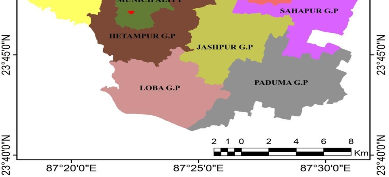
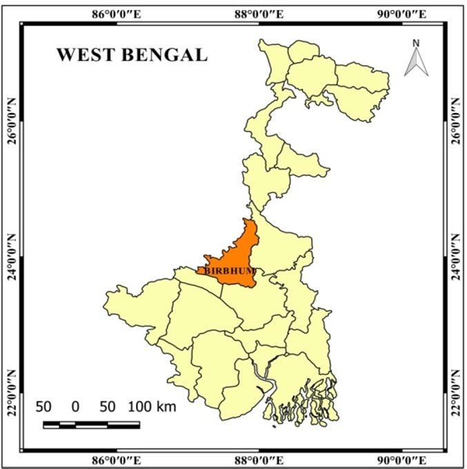
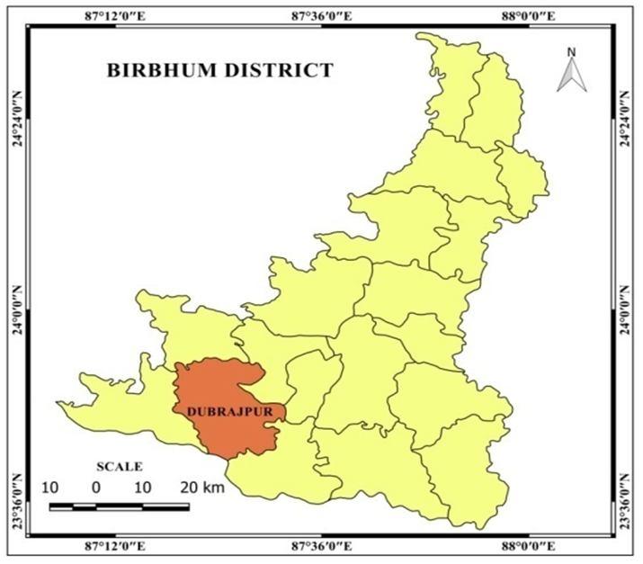
Dubrajpur block (Fig. 1) is an administrative division in Suri Sadar subdivision of Birbhum district (Fig. 1) in the Indian state of West Bengal (Fig. 1), India. The block has an area of 342.71 km². The study area is a part of lateritic Rarh plain region enclosed between 23°41′3.37″N. to 23°54′14.27″N. latitudes and 87°18′27.14" E. to 87°31′13.22″ E. longitudes covering an area of 342.71 sq. km. “The region constitutes the transitional zone between two mega physiographic provinces of the Chottanagpur plateau fringe and the Bengal basin” (Bhattacharya, 2013; Saha, 2011; Roy, 1985). The study area lies in between the river Mayurakshi in North and Ajay in the South. Administratively, the Dubrajpur block (Population 181412 as per 2011 Census) is bounded by Rajnagar block in the North, Khoyrasole block in the West and Suri-I and II block in the East while the district boundary of Burdwan forms the sourthern limit. It is served by 3 police stations namely Dubrajpur, Ilambazar and Sadaipur and constitutes 10 gram panchyats. Geologically the region is having Dharwanian sedimentary deposition followed by Hercinian orogeny with lateritic soil and hard clays deposition (GSI 1985). The relief of the catchment ranges between 50 m. to 150 m. Rolling uplands and lateritic badlands in the upper part followed by wide undulating plain surface characterize the morphological features. Monsoon climatic rhythm is prevailing in the basin with high seasonal concentration of rainfall. Monsoon season (June-September) carries about 80% of total annual rainfall. The area covered mostly with the laterite, loamy (Red and Plateau Stulfs), clayey (Ustochrents and Huplustulfs) soil (NATMO 2001). A part of the region is claded with sparse sal forest and highly prone to agricultural invasion and high rate of soil erosion susceptibility.


ISSN: 2321-9653; IC Value: 45.98; SJ Impact Factor: 7.538
Volume 11 Issue III Mar 2023- Available at www.ijraset.com
A. Development of Thematic Layers

To perform AHP method, different thematic layers have been developed by processing of digital images, digitizing existing maps and so on. To identify the groundwater potential zone in the study area, thematic layers of geology, geomorphology, slope, rainfall, landuse, soil, lineament, drainage frequency and drainage density were generated using topographic maps, thematic maps, field data and satellite image in GIS environment. The required data and maps have been collected through various sources. All the collected maps and data have been registered into Universal Transverse Mercator Projection northern zone 45 datum WGS1984. The drainage map and contour map has been prepared from from the Survey of India (SOI) topographical map (sheet no. 73M/5, 73M/6, 73M/9 and 73M/10) on 1:50,000 scale. Grid index feature in ArcGIS software has been implied to prepare drainage density and drainage frequency map. Slope map has been prepared from the contour map using Wentworth’s method. Rainfall distribution map has been prepared from District planning map, NATMO on 1:1,000,000 scale. The soil texture map has been collected from Birbhum distric portal (htpp://www.birbhum.nic.in). The land use and land cover (LULC) map was prepared from LANDSAT-8 image (Path/Row:139/044) collected from USGS Geo-portal (https://earthexplorer.usgs.gov/). Then supervised classification was done by using maximum livelihood classification algorithm in ArcGIS environment. Geological map has been collected from District resource Map Series, Birbhum District, GSI on 1:250000 scale. Geomorphological map has been prepared from LANDSAT-8 image (Path/Row:139/044).The complete work flow of methodology is given in figure 2.
Re-classification
Application of AHP to assign weight in theme and ranking method to assign weight in feature classes
Weighted overley analysis in
Accuracy assessment of the Groundwater potential zones
for preparing thematic maps

ISSN: 2321-9653; IC Value: 45.98; SJ Impact Factor: 7.538
Volume 11 Issue III Mar 2023- Available at www.ijraset.com
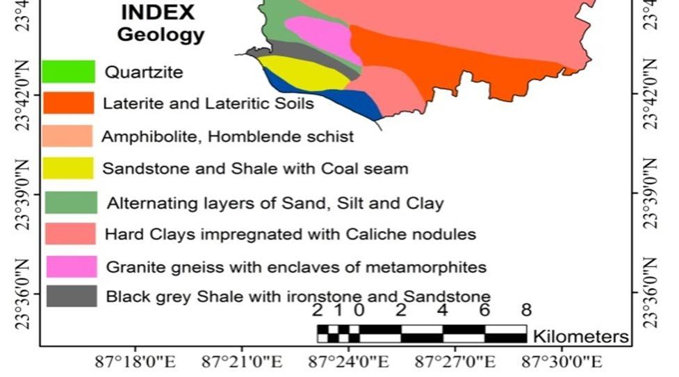
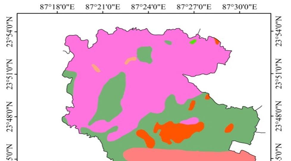
“Occurrence of groundwater primarily depends on the geological formation”(Hachem et al. 2015). There are six (Fig.3) major lithological units in the stuy area viz. Granite gneiss with enclaves of metamorphosis, Alternative layers of sand silt and clay, Hard clays impregnated with Caliche nodules , Laterite and lateritic soils, Sandstone and Shale with Coal seam, Black grey Shale with ironstone and Sandstone. The underground rock structure of an area directly influences the rate of percolation and subsurface flow of water. On the basis of the nature of the porosity and permeability of different lithological units of the study area, Laterite and lateritic formation has been given maximum weightage. Alternating layers of Sand, Silt and Clay, Hard Clays impregnated with Caliche nodules and Black grey Shale with Ironstone and Sandstone have moderate influence, Sandstone and Shale with Coal seam has poor influence and Granite gneiss with enclaves of metamorphites has been identified with very poor influence for their nature of very little primary porosity and permeability.
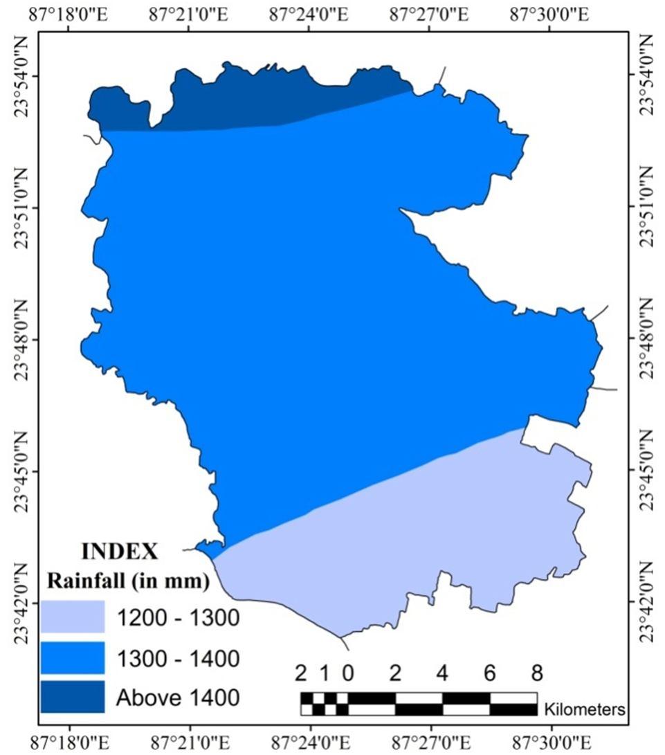
“Rainfallisthemajorhydrologicalsourceofgroundwater storageand also determines its fluctuation”(Agarwal et al. 2013; Magesh et al. 2012). As the study area falls under subtropical monsoon climatic zone, the maximum occurrence of rainfall (80%) is experienced during the month of June to September from southwest monsoon wind. There are three rainfall zones have been found in the study area. The north and northwestern part of the study area are characterized by high rainfall (>1400mm), the entire eastern, western and middle part is characterized by moderate rainfall (1300-1400 mm), south and south western part of the study area is characterized by low rainfall intensity (Fig. 4). “The rate of groundwater recharge depends on the rate of the addition of water to the hydrological system” (Thomas et al. 2016). It is very clear to understand that greater rainfall intensity means better ground water recharge. So, to high rainfall zone has been given maximum weightage and vice versa to determine ground water potential zones of the region.
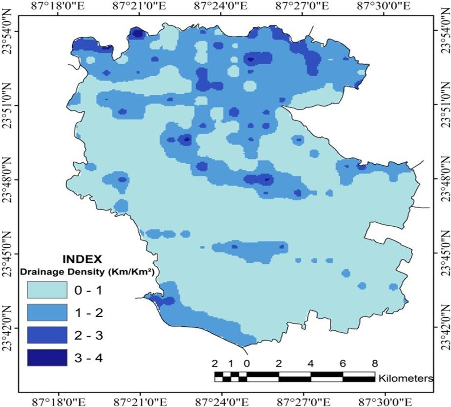
“Drainage densityrefers to the stream length per unit area in the region of the watershed”(Horton, 1932; Strahler, 1952). “Drainage density is controlled by the nature and structure of rocks, soil properties and slope gradient, etc.” (Manap et al. 2013). “Drainage density is an inverse function of permeability” (Chowdhury et al. 2009; Magesh et al. 2012; Agarwal et al. 2013). So, it is one of the most important factors to delineate groundwater potential zone. High drainage density indicates high surface runoff and low percolation of surface water which result in less ground water recharge. Therefore, higher ranks have been assigned to the areas with low drainage density and vice versa. In the study area, low drainage density has been found in undulating upper alluvial plain region in the western and south eastern part of the study area whereas high drainage density have been found in the plateau fringes and pediments in the northern and north eastern part of the study area (Fig. 5)
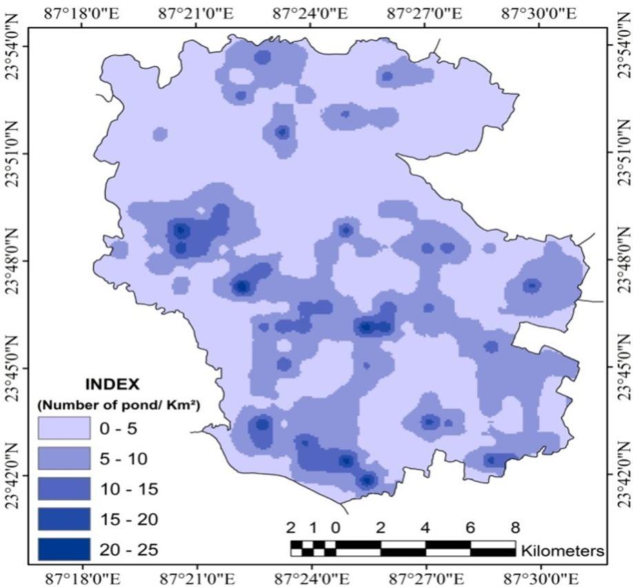
“Pond is another important parameter for recharging groundwater and ponds are often been used for artificial groundwater recharge” (Hofkes and Visscher, 1986; Kumar et al. 2011; Mukherjee, 2016). The number of pond or water bodies of an area positively influences the infiltration rate of water as they can hold large volume of water. So, more pond frequency indicates more ground water potentiality and vice versa. Therefore, high priorityhas been assigned to the high to veryhigh (15-25/Km2) pond frequent zones whereas low priority has been assigned tothe zones having pond frequencyrangingfrom 0 -10/ Km2 (Fig.6)
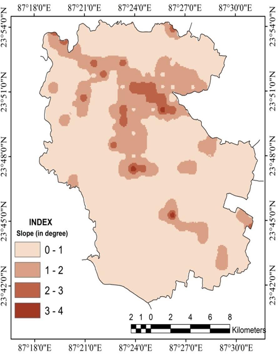
“Slope is considered as one of the most important topographic factors and surface indicators to assess groundwater potential” (Ettazarini, 2007; Al’Saud, 2010). “Slope determines surface runoff and vertical percolation of water; hence it affects groundwater recharge processes” (Adiat et al. 2012; Bhunia et al. 2012; Kumar et al. 2014). “Infiltration is inversely related to the slope” (Rahmati et al. 2015). Lower the inclination of ground provide more time to infiltration of water, hence increase the rate of ground water recharge and vice versa. So, lower degree of slope has given higher importance to ground water potentiality The averageslope map of the areahasbeen prepared from SOI topographical maps using Wentworth method (Fig. 7).
“Lineaments are surface manifestations of structurally controlled features, such as joints, straight course of streams and vegetation alignment” (Abdullahi et al. 2013).


ISSN: 2321-9653; IC Value: 45.98; SJ Impact Factor: 7.538
Volume 11 Issue III Mar 2023- Available at www.ijraset.com
“Lineaments are the structurally controlled linear, recti- linear, curvilinear features of tectonic origin, which can be easily identified from satellite imagery”(Pradhan et al. 2006; Magesh et al. 2012; Jhariya et al. 2016). “Lineaments influence the rate of infiltration and help to recharge groundwater” (Rao et al. 2001). “An area with higher lineament density is favorable for the groundwater potential”(Haridas et al. 1998). In the present study, lineament density map (Fig.8) has been prepared from ISRO’s Geo-portal Bhuvan. Higher importance has been given to the areas with higher lineament density and vice versa. Maximum portion of the study area has been recorded with very low lineament density.
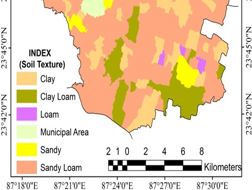
Soil texture refers to the proportion of sand, silt and clay sized particles that make up the mineral fraction of the soil. Textural classes of a soil strongly control the amount of water the soil can hold and the rate of water movement through the soil. Soil texture is an important parameter for the identification of groundwater potential zone “Soil texture determines the percolation rate and recharge of groundwater” (Nolan et al. 2003; Bardy, 1984; Sahai, 1990; Biswas and Mukherjee, 1994). “Finer the soil texture, lower will be the infiltration capacity and resultant poor groundwater recharge” (Doll and Fiedler, 2008). In the present study, maximum weightage has been assigned to the sandy texture for its high infiltration rate and minimum weightage has been assigned to the clay structure for very low infiltration rate. The soil texture map of the study area has been collected from Birbhum District Portal andas perthemap,themajorsoiltexturalclassesofthestudyareaaresandy, clay loam, sandy loam, clay and loam (Fig.9).
8)
“Geomorphological units, physical features of the earth’s surface and the near-surface underground, represent significant aspects in hydrogeological investigations, evaluation of topography, and delineation of groundwater resources” (Krishnamurthy et al. 1995). “Geomorphology represents the landform and topography of an area, and is one of the main factors used widely for the delineation of groundwater potential zones” (Arulbalaji et. al. 2019). Therefore geomorphological map of the study area has been prepared from Landsat-8 satellite image and eight major geomorphic units have been observed in the study area (Fig.10). Among the geomorphic units, point bar and channel bar has been given maximum weightage followed by older alluvial plain for their good infiltration capacity. Lateritic upland and lateritic plain have been identified with poor ground water potential influencing factors whereas pediplain and valley fill has given minimum weightage.
9) Land use and land cover
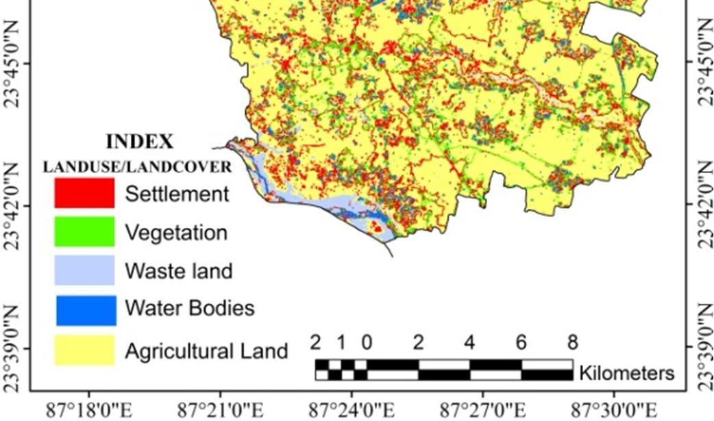
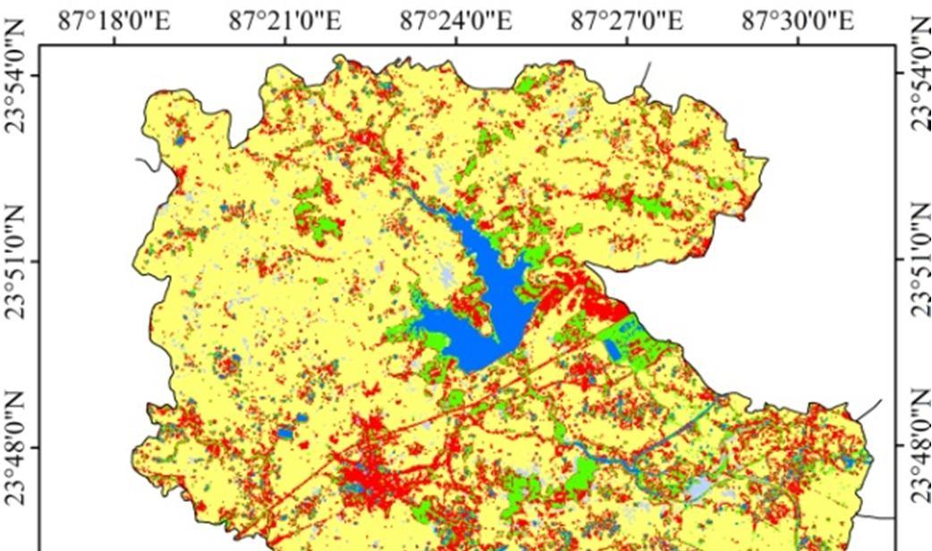
“Landuse/landcover isan importantindicator of the extent of groundwater requirement and utilization” (Jhariya et al. 2016). “It also provides knowledge about the recharge of groundwater” (Singh et al. 2011). The land use/land cover map (Fig.11) of the study area has been prepared from Landsat-8 image by supervised classification in Arc GIS 10.5 software. Five major LULC categories have been identified in the map viz. water bodies, vegetation cover, agricultural land, settlement, and waste land. Among the LULC categories, the largest influence has been given to water bodies as stagnant water is an important source of ground water. Vegetation cover and agricultural land also play a vital role in ground water recharging hence have been identified with good influencing factors. LULC categories like waste land and settlements accelerate the rate of surface flow and responsible for low infiltration rate. So, these two categories are given minimum weightage.
B. Deriving the weights using AHP
“Analytic Hierarchy Process (AHP) used for decision making in which a problem is divided into various parameters, arranging them in a hierarchical structure making judgments on the relative importance of pairs of elements and synthesizing the results” (Saaty, 1999; Agarwal et al. 2013). The relationship between the nine thematic layers has been derived using Analytic Hierarchy Process (AHP). “The methodology for deriving the weights to the thematic layers and their corresponding classes using AHP involves following steps” (Saaty, 1999; 2004; Agarwal et al. 2013; Kumar et al. 2014; Kumar and Jhariya, 2015).

1) Step 1: Construction of model
At first, well defined elements or parameters (thematic layers) are essentially required to construct AHP model. We need to have a clear conception about ground water availability controlling factors to construct the model.
2) Step 2: Generation of pairwise comparison matrices:
The relative importance values are determined with Saaty’s 1–9 scale (table 1), where “a score of 1 represents equal importance between the two themes, and a score of 9 indicates the extreme importance of one theme compared to the other one” (Saaty, 1980).
ISSN: 2321-9653; IC Value: 45.98; SJ Impact Factor: 7.538

Volume 11 Issue III Mar 2023- Available at www.ijraset.com
“The final weight of the thematic layers has been obtained from the normalized value of the eigenvalue or the priority vectors which are associated with maxi- mum eigenvalue of the ratio matrix” (Jha et al. 2010; Adiat et al. 2012).
To calculate consistency ratio (CR), the following formula has been used
CR =
Where RI indicates random consistency index whose value depends on the order of the matrix (Table 2) and CI indicates Consistency index, which can be obtained from the fol- lowing formula
CI =

Where λmax is the largest eigen value of the pair wise comparison matrix and n is the number of classes.

ISSN: 2321-9653; IC Value: 45.98; SJ Impact Factor: 7.538



Volume 11 Issue III Mar 2023- Available at www.ijraset.com

ISSN: 2321-9653; IC Value: 45.98; SJ Impact Factor: 7.538

Volume 11 Issue III Mar 2023- Available at www.ijraset.com
Each thematic layer has been classified into different groups according to their range value. To assign normalized weight for each feature of a thematic layer, ranking method has been followed. “In this method every criterion which is under consideration is ranked on the basis of the determination of groundwater potential” (Chowdhury et al. 2013). “Two methods are generally used to rank features, straight ranking (most important = 1; second important = 2 and so on) or inverse ranking (least important = 1; next least important = 2 and so on)” (Yahaya et al. 2010). “In the present study, inverse ranking has been used. In this rating method rating 1 to 5 has been adopted where 1, 2, 3, 4 and 5 represent very low, low, medium, high and very high groundwater storage potential” (Kumar etal. 2014;Jhariya et al. 2016).


ISSN: 2321-9653; IC Value: 45.98; SJ Impact Factor: 7.538
Volume 11 Issue III Mar 2023- Available at www.ijraset.com
“GWPI is a dimensionless quantitative method that helps to delineate groundwater potential zone in the study area” (Rahmati et al. 2015; Razandi et al. 2015).“To get groundwater potential zones, weighted linear combination (WLC) technique is employed to demarcate groundwater potential zones. The following formula is used to do this” (Jha et al. 2010; Agar- wal et al. 2013; Kumar et al. 2014; Shekhar and Pandey2014; Rahmati et al. 2015;Razandi et al.2015).
GWPI = GlWGlWi + RfWRfWi + DdWDdWi + PdWPdWi + SlWSlWi + LdWLdWi + StWStWi + GmWGmWi+ LULCWLULCWi
where W = normalized weight of each thematic layer; Wi = normalized weight of the features; Gl = Geology; Rf= Rainfall; Dd= Drainage density; Pd = Pond drequency; S = Slope; Ld = Lineament Density; St = Soil texture; Gm = Geomorphology; LULC = Landuse/Landcover. GWPI grouped into five classes having very low, low, moderate, high and very high groundwater potential zones.
E. Deriving weight of Theme by AHP Model

The pair wise comparison matrix of groundwater prospecting thematic layers has been computed on the basis of AHP model. The normalized weight for each thematic layer has been determined by calculating eigenvector or priority vector (Table 4). As per the table, Geology is the most important parameter of ground water storage which occupies 28% of weightage followed by Rainfall(18%), Drainage Density(16%), Pond Density(10%,) Slope(8%), Lineament Density(7%), Soil Texture(6%), Landuse/Landcover(4%), Geomorphology(3%). Using the following formula,the consistency of the decision regarding grund water prospecting factors or the selected thematic layers has been checked.
CI = = 0.046418
CR = = 0.0320
For n = 9, CR is 0.0320, which is < 0.10. It implies that there is a reasonable level of consistency in the pairwise comparison matrix.
All feature classes of each parameter has been assigned with weight in five point scale. In the scale 5 rank signifies very good ground water prospect, 4 is for good, 3 for moderate, 2 for poor and 1 for very poor ground water prospect. The normalization of feature weights of each thematic layer has been shown in table 5

ISSN: 2321-9653; IC Value: 45.98; SJ Impact Factor: 7.538
Volume 11 Issue III Mar 2023- Available at www.ijraset.com
A. Classification of groundwater potential zone


As per AHP model the final output map (Fig. 12) of Ground Water Potential zone has been obtained which is categorized into five classes, viz. very high, high, moderate, poor and very poor potential zones as per the natural break of obtained highest and lowest value using Arc GIS 10.5 software. Among the zones, very high potential category occupies 1.61%, high potential category occupies 26.60%, moderate occupies 6.70%, poor category occupies 28.84% and very poor category records for 36.25% of the total geographical area of Dubrajpur block. So, it is very clear to understand that, maximum part (65.09%) of the study area is characterized by poor to very poor category.
The output model of groundwater potential zone signifies that the zonal categories largely influenced by physical parameters like geology, rainfall, drainage density and so on. Parts of some villages viz. Kamalpur, Sahapur, Ghoratori, Shibrautara, Kendula, Hetampur, Chandrapur, Ashatganja, Krishnanagar, Jashpur, Kantari, Pachiara, Bazarpur, Lahagram in the central part of the study area have been identified as very high groundwater potential which are characterized by Laterite and Lateritic geological pattern, occurrence of high rainfall, low drainage density, high pond density, lesser degree of slope, high lineament density, sandy loam texture of soil. All of the factors observed as the very much influential for availability of ground water in these zones. On the other hand, areas characterized by less porous granite and gneiss, high drainage density, pond and lineament density have been identified as very low groundwater potential zone. A large part of Dubrajpur municipal area, parts of villages like Bhonra, Radhamadhabpur, Gopalnagar, Rampur, Jatra, Dhagram, Asanshuli have been identified as low to very low ground water potential zone. In present context identification of groundwater potential zone is very important because it help researchers and planners for better understanding of the availability of water resource of an area. On the basis of the availability of ground water, crop selection, settlement development, plantation can be initiated in the proper way. As the ground water potential zoning map has been done only on the basis of physical parameters and socio-economic parameters like expenditure of ground water for domestic and irrigation has been completely excluded, the map contains some errors. There are some areas in the map identified as very high potential zones in the ground water draft is low according to the report of CGWB and vice versa. Therefore, we need to include ground water recharge-draft information in our future work for an errorless result.


ISSN: 2321-9653; IC Value: 45.98; SJ Impact Factor: 7.538
Volume 11 Issue III Mar 2023- Available at www.ijraset.com


ISSN: 2321-9653; IC Value: 45.98; SJ Impact Factor: 7.538
Volume 11 Issue III Mar 2023- Available at www.ijraset.com


ISSN: 2321-9653; IC Value: 45.98; SJ Impact Factor: 7.538
Volume 11 Issue III Mar 2023- Available at www.ijraset.com

ISSN: 2321-9653; IC Value: 45.98; SJ Impact Factor: 7.538

Volume 11 Issue III Mar 2023- Available at www.ijraset.com
1) To validate the present study, borehole-yield data have been taken into consideration. Forty borehole locations and yield data are shown in Fig. 4 and Table 6 as per field observation and previous investigations by WBPHED. The yield data have been classified into four categories viz. <50 LPM (very low yield), 50 – 100 LPM (low yield), 100 – 200 LPM (Moderate yield), 200
400 LPM (High yield). Table 6 is showing a comparison between the actual yield data collected from the field observation and expected yield range obtained from the potential map. A remark of agreement and disagreement has been also incorporated in the table.
2) The accuracy level of the prepared ground water potential map has been measured by performing the following steps,
a) Total number of drilled bore hole=40
b) Number of boreholes under agreement of coherence between actual and predicted yield range=32
c) Number ofboreholesunderdisagreementofcoherencebetweenactualandpredicted yield range=8
Accuracyprediction= × 100
= × 100 = 80 %

The AHP model based on GIS techniques that has been used in the present study reveals that, there is 80% accurate prediction value. So there should not be any doubt about the reliability and relevance of the present work.
The present study is a successful outcome of application of geospatial techniques along with AHP method to find out the groundwater potential zones of Dubrajpur block, Birbhum district. The study reveals that maximum part of the Dubrajpur block is characterized by poor to very poor groundwater potentiality. On the other hand, 28.21% of the total geographical area of the study area is characterized by high to very high ground water potentiality which can be very much helpful for sustainable groundwater management in the area. In present situation, wastage and unauthorized use of water causing water depletion, ground water crisis is a common problem everywhere. The present work would be very much important for the planners and common people to chalk out exact effective drilling site to extract maximum ground water resource. Authorities engaged with ground water exploration may confidently rely on the final output map to drill boreholes or to digging wells in any location of the block.
[1] Adiat, K. A. N., Nawawi, M. N. M. & Abdullah, K. Assessing the accuracy of GIS-based elementary multi criteria decision analysis as a spatial prediction tool–a case of predicting potential zones of sustainable groundwater resources. J. Hydrol. 440, 75–89 (2012).
[2] Agarwal, E., Agarwal, R., Garg, R. D., & Garg, P. K. (2013). Delineation of groundwater potential zone: An AHP/ANP approach. Journal of Earth System Science, 122(3), 887–898.
[3] CGWB. (2014). Groundwater Year Book of West Bengal and Andaman and Nicobar Island 2014-15. Ministry of Water Resources, Government of India. http://www.cgwb.gov.in. Accessed January 20, 2017.
[4] Das,N. & Mukhopadhyay,S.(2018). Application of multi-criteria decision making technique for the assessment of groundwater potential zones:astudyonBirbhumdistrict,WestBengal,India. Article in Environment Development and Sustainability · July 2018. https://doi.org/10.1007/s10668018-0227-7
[5] Horton, R. E. (1932). Drainage basin characteristics. Transactions of the American Geophysical Union, 14, 350–361.
[6] Jaiswal, R. K., Mukherjee, S., Krishnamurthy, J. & Saxena, R. Role of remote sensing and GIS techniques for generation of groundwater prospect zones towards rural development–an approach. Int. J. Remote Sens. 24, 993–1008 (2003).
[7] Jhariya, D. C., Kumar, T., Gobinath, M., Diwan, P., & Kishore, N. (2016). Assessment of groundwater potential zone using remote sensing, GIS and multicriteria decision analysis techniques. Journal of the Geological Society of India, 88, 481–492.
[8] Kumar, T., & Jhariya, D. C. (2015). Land quality index assessment for agricultural purpose using multi-criteria decision analysis (MCDA). Geocarto International, 30(7), 822–841. https://doi. org/10.1080/10106049.2014.997304
[9] Madrucci, V., Taioli, F. & de Araújo, C. C. Groundwater favorability map using GIS multicriteria data analysis on crystalline terrain, Sao Paulo State, Brazil. J. Hydrol. 357, 153–173 (2008).
[10] Majumdar, D. (1975). West Bengal District Gazetteer, Birbhum. State editor, Government of West Bengal, Kolkata (pp. 1–79).
[11] Razandi, Y., Pourghasemi, H. R., Neisani, N. S. & Rahmati, O. Application of analytical hierarchy process, frequency ratio, and certainty factor models for groundwater potential mapping using GIS. Earth Sci Informatics 8, 867–883 (2015).
[12] Saaty, T. L. (1980). The analytic hierarchy process: Planning, priority setting, resource allocation. New York: McGraw Hill.
[13] Saaty, T. L. (1999). Fundamental of analytic network process. In International Symposium of the Analytic Hierarchy Process (ISAHP), Kobe, Japan.
[14] Saaty, T. L. (2004). Fundamental of analytic network process-multiple network with benefits, costs, oppor- tunities and risks. Journal of Systems Science and Systems Engineering, 13(3), 348–379. https://doi. org/10.1007/s11518-006-0171-1
[15] Sander, P., Chesley, M. M. & Minor, T. B. Groundwater assessment using remote sensing and GIS in a rural groundwater project in Ghana: lessons learned. Hydrogeol. J. 4, 40–49 (1996).
