
V.32 JANUARY 2023 VOLUME THIRTY-TWO 2023 Winter Issue H ydro V isions o fficial P ublication of t H e G roundwater r esources a ssociation

HYDROVISIONS is the official publication of the Groundwater Resources Association of California (GRA).
GRA’s mailing address is 808 R Street. Suite 209, Sacramento, CA 95811. Any questions or comments concerning this publication should be directed to the newsletter editor at hydrovisions@grac.org
The Groundwater Resources Association of California is dedicated to resource management that protects and improves groundwater supply and quality through education and technical leadership.
EDITOR
Rodney Fricke hydrovisions@grac.org
EDITORIAL LAYOUT
Smith Moore & Associates
EXECUTIVE OFFICERS
PRESIDENT
R.T. Van Valer
Roscoe Moss Company
Tel: 323-263-4111
VICE PRESIDENT
Christy Kennedy
Woodard & Curran
Tel: 925-627-4122
SECRETARY
Erik Cadaret
West Yost
Tel: 530-756-5905
TREASURER
Rodney Fricke
GEI Consultants
Tel: 916-631-4500
DIVERSITY, EQUITY AND INCLUSION OFFICER
Marina Deligiannis
Lake County Water Resources
Tel: 707-263-2213
HIMMEDIATE PAST PRESIDENT
Abigail Madrone
West Yost Associates
Tel: 530-756-5905
ADMINISTRATIVE DIRECTOR
David Garrison
Groundwater Resources Association of California
dgarrison@grac.org
Jena Acos
Brownstein Hyatt Farber Schrek
Tel: 805-882-1427
Murray Einarson
Haley & Aldritch, Inc.
Tel: 530-752-1130
Yue Rong
Los Angeles Regional Water Quality Control
Tel: 213-576-6710
Abhishek Singh
INTERA
Tel: 217-721-0301
Clayton Sorensen
Balance Hydrologics, Inc.
Tel: 510-704-1000 x206
John Xiong
Haley & Aldritch, Inc.
Tel: 530-752-1130
Roohi Toosi
APEX Environmental & Water Resources
Tel: 949-491-3049
Moises Santillan Water Replenishment District 562-275-4279
To contact any GRA Officer or Director by email, go to www.grac.org/board-of-directors
The statements and opinions expressed in GRA’s HydroVisions and other publications are those of the authors and/or contributors, and are not necessarily those of the GRA, its Board of Directors, or its members. Further, GRA makes no claims, promises, or guarantees about the absolute accuracy, completeness, or adequacy of the contents of this publication and expressly disclaims liability for errors and omissions in the contents. No warranty of any kind, implied or expressed, or statutory, is given with respect to the contents of this publication or its references to other resources. Reference in this publication to any specific commercial products, processes, or services, or the use of any trade, firm, or corporation name is for the information and convenience of the public, and does not constitute endorsement, recommendation, or favoring by the GRA, its Board of Directors, or its members.
President’s Message
Page 4
Women Advancing Women

Page 6
ESG | Climate Resilient & Sustainable Remediation
Page 8
Wells and Words
Page 10
GeoH2OMysteryPix
Page 14
When the Wells Run Dry
Page 16
Overview of DWR’s Statewide AEM Surveys
Project
Page 22
Polyfluoroalkyl Substances (PFAS)

Page 28
SGMA Implementation
Summit
Page 32
Toxic Terra
Page 34
Parting Shot
Page 38
Thank You To Our Contributors
Page 40
6 Women Advancing Women
28 Polyfluoroalkyl Substances (PFAS)
Happy New Year!

I can’t believe it is already January 2023, another great year of important groundwater management activities.

What a year we have had in GRAs 30th Anniversary! The 2022 year started off strong as we hosted GRA’s largest event in our 30-year history, ISMAR11. Attendees joined us from all over the world both in person and virtually for the weeklong event including presentations, workshops, field trips, and lots of time for socializing and networking at our outstanding receptions. We followed up this event in June with two of our signature events, combined, to make one exceptional event. The Law and Legislation Forum was one of the best I have attended in my 11 years with GRA and boasted some top notch speakers. Our GSA Summit, on the second day, sparked some great discussion in a very intimate setting, highlighted by our closing panel Coffee with DWR and the State Board. It was truly intriguing to be able to have the close connections with Paul Gosselin and Anthony Wohletz to conclude the event. Our last event of the year, The Western Groundwater Congress was truly an amazing and inspirational event. I was so proud of all who invested their time and energy into our grand signature event, and made it one of the best GRA events of all time.
I am truly so thankful for all of our amazing volunteers! Our exceptional Board members have made this job of President so enjoyable thanks to all of their hard work, passion, and dedication to this organization and our mission. Our branch leadership continues to impress me with all of their creativity and their desire to develop fun and educational ways to get their branches together both virtually and in person. A huge shout-out goes to all of those volunteers who continue to step up and help create outstanding content, run committees, and to those who constantly sponsor this wonderful organization with their time, money, and energy. GRA could not be the incredible organization it is today without all of you, and for that you have my utmost respect.
As we finish up the this holiday season, my hopes are that your workloads have slowed down, so you can enjoy time with your families and loved ones and have opportunities to create memories that will last you a lifetime. Trusting you all had a safe, happy, and fun holiday season, and I can’t wait to see you all in the New Year! As we kick off 2023, here are some new year’s resolutions related to GRA for you:
• Join one of our 7 regional branches
• Attend one of our 4 conferences/in person events
• Tune in for GRA-Casts and branch meetings
This year is another pivotal time for SGMA implementation with expected GSP reviews and more guidance and information from DWR. Remember that GRA strives to provide you with the most up-to-date information on all things SGMA and we have 3 events to help you navigate this complex state-wide CA groundwater management effort.
Happy New Year,

On September 20th, a group of approximately 40 women and 7 men gathered for a workshop focused on Women Advancing Women for the Good of Water at the Western Groundwater Congress in Sacramento, CA. The workshop was sponsored by Balance Hydrologics, Dudek, Provost & Pritchard, and West Yost. This meeting was a first for GRA and a step in GRA’s journey to explore and incorporate more purposeful discussions, content, and events in support of building a more diverse, equitable and inclusion organization. The workshop was developed by GRA’s DEI Committee and facilitated by committee member and GRA’s Immediate Past President, Abigail Madrone.
The stellar panel of incredibly smart, talented, and driven women represented the public and private sectors of water and groundwater resources as well as education. Panelists shared poignant stories about mentors or champions in their careers that helped open a door, provided guidance at critical intersection, or simply asked the right question at the right time. Panelist acknowledged the role of both women and men in supporting their respective career development and accomplishments.
• Marina Deligiannis, Deputy Director Water Resources Department, Lake County
• Dr. Rosemary Knight, Professor, Stanford University
• Jessica Law, Executive Director, Water Forum
• Kamie Loeser, Water and Resource Conservation Director, Butte County
• Lisa Turturro, Chief Client Officer, Haley & Aldrich
Both panelists and participants gained deeper insights into the challenges and opportunities for women in water from different career perspectives. In general, women excel in creating collaborative work environments and in opening communication pathways, and yet all women lead, communicate and problem solve differently.

There was consensus amongst the panelists that there is a greater need for empathy, self-awareness, and kindness in professional and personal interactions. The Golden Rule, treating others how you want to be treated, is only a step in a positive direction. To engage with empathy and awareness more fully, people need to consider the Platinum Rule, which means you are actively seeking to understand how the people around you want to be treated.

All participants also made a group commitment to never ask a colleague when or if they plan or want to get married, regardless of gender identity, and never ask if someone is pregnant or wants to have children. These questions come across as being gender specific and are deeply private.
The panelists offered words of wisdom in their anecdotes and the audience question and answer session. Women were encouraged to speak up, and let your voice be heard. Panelists reminded participants to be wary of imposter syndrome, the persistent inability to believe that one’s success is deserved or has been legitimately achieved because of one’s own efforts or skills, and know that your opinions, questions, and ideas bring significant value.
The panel wrapped up on a high note and a share commitment to collectively support the career development and opportunities for women to advance in the water industry through an expanded network, new connection to water leaders and a more enlightened GRA.


“THE FIGHT AGAINST CLIMATE CHANGE IS GOING TO CHANGE MORE IN THE NEXT FOUR YEARS THAN IT HAS IN THE PAST 40. THE GREAT STORY OF OUR LIVES IS JUST BEGINNING. WELCOME ABOARD.”
-THE ATLANTIC OCTOBER 5, 2022
Welcome aboard indeed – welcome aboard a paddle board as you learn with the GRA community at the beach in San Diego on February 6-7th, 2023. We will be hosting GRA’s first ever climate and sustainable remediation event – amplifying your learning and vocabulary on all things E- Environment, S – Social, and G-Governance. At GRA – we embrace being a different kind of professional organization. What this means for this event is that we are bringing in the innovators and movers on the regulatory side of climate change topics and creating not just listening space, but networking and discussion space for all attendees grappling with new terminology and an unclear path in daily implementation around these accelerating external drivers. We have invited key speakers in this space from states that are far ahead due to climate vulnerabilities, and educational partners like the Sustainable Remediation Forum to coach you on tools and approaches for incorporating sustainability and resiliency into remediation projects.
This conference will focus in the following areas:
• Environment, Social, Governance (ESG) – What is it, and where does groundwater intersect
• Sustainable Resilient Remediation – Leveraging groundwater site cleanup to incorporate ESG and climate adaptation
• Climate Change Impacts in the Industry – Bracing for changing groundwater levels and new regulations
We are inviting some of the top industry professionals from regulatory agencies, private companies, and the biggest thinkers in the West to share lessons learned, best practices and emerging ideas on the evolving climate regulations.
The Impact of Sea-Level Rise on Remediation of Near-Shore Properties: New Challenges for an Uncertain Future at the ESG Climate Resilient & Sustainable Remediation Symposium to discuss how sea level rise-induced groundwater rise presents challenges for existing and future remedies at nearshore properties. Dr. Benjamin Hagedorn will present an investigation on the effects of SLR on groundwater quality. Dr. Raghavendra Suribhatla will discuss the range of conceptual models used for near-shore hydraulic effects in the intertidal zone and coastal aquifers. Lucas Goldstein, PE, PG, will describe approaches to conducting soil, soil-vapor, and groundwater remedy vulnerability assessments. Peter Zawislanski, PG, CHg will address SLR-related challenges in remedial planning, SLR-resilient remedial technologies, and managing long-term environmental risks.
• We are thrilled to welcome the principal author of Washington state’s climate resiliency guidance for contaminated sites, Chance Asher from the Toxics Cleanup Program in the Department of Ecology as our keynote speaker!
• On day one of the conference, Michael Montgomery from EPA Region 9 in San Francisco will share what climate change means for Superfund sites, how each stage of cleanup will be impacted, and when to consider changing remedies that are already in place. Cheryl Prowell from the State Water Resources Control Board (State Board) in Sacramento and Lisa Horowitz McCann from the San Francisco Bay Regional Water Quality Control Board will distill down what the Regional Boards are doing and how each program, from site cleanup to wastewater management, will need to consider climate change and all associated impacts into the future. Nelline Kowbel and Dominique Forrester from the Department of Toxic Substances Control (DTSC) Berkeley and Sacramento offices will bring another State perspective on how they are working with their sister agency on collaborative oversight of contaminated sites, and share some considerations on when a vulnerability assessment will be required at certain sites. The roundtable discussion will include the local San Diego Regional Board’s Sean McClain, who will focus on specific programmatic requirements around sea level and groundwater rise at cleanup sites.
• Day two of the conference will feature Annalisa Kihara of the State Board and Todd Sax of DTSC to discuss environmental, social governance, and direct conversation around equity in regulatory decisionmaking. The conference will be wrapped up by Chris Hyun of the State Board who will summarize actions the State is taking around climate change impacts to all site types, and summarize the goal of improving social equity, diversion and inclusion.
Thank You to Our Cooperating Partners at the Sustainable Remediation Forum and the Chinese-American Engineers and Scientists Association of Southern California.
And a Special Thanks to Our Sponsors!
Woodard & Curran
West Yost Associates
Water Replenishment District
INTERA Incorporated
Roscoe Moss Company
Montgomery & Associates
Terraphase Engineering Inc.
GEI Consultants, Inc.
Haley & Aldrich
S.S. Papadopulos & Associates, Inc.
Rincon Consultants, Inc.
Blaine Tech Services
Confluence Environmental, Inc.
This conference will take place on the beach at the Kona Kai Resort in San Diego over a day and half. The venue is so epic, we’ve purposely put the conference on a Monday, so you can bring the family for the weekend and enjoy the location.
Register Today! Closes January 25, 2023. Onsite registration will be available!


coMbininG GeoPHysical loGs and sequence stratiGraPHy and aPPlyinG to site cHaracterization
by David W. Abbott, P.G., C.Hg., Consulting GeologistIn mid-December 1986, I had the opportunity to conduct a wide-ranging groundwater contamination review and study (Phase 1) for a chemical recycling facility in San Jose, CA (discussed briefly in a previous Wells and Words [Fall 2021] article and merits further discussion here). This facility was established in 1973 to reclaim, recycle, and dispose of industrial solvents used in Silicon Valley. Since 1983, the facility was under regulatory review by the CA Regional Water Quality Control Board and the CA Department of Health Services. Later, the property would be placed temporarily on the Federal Superfund Site List (low priority) by the US Environmental Protection Agency.
The 3.2-acre property (ground surface elevation ≈70 feet [ft] above mean sea level) is located ≈7 miles south of San Francisco Bay and along the central axis of the Santa Clara Valley. The shape of the property is a quadrilateral with roughly equal side lengths (≈365 ft). Between 1983 through 1986, two consulting firms installed 85 borings which included 67 monitoring wells that were distributed between five “aquifers” in order to characterize the subsurface geology, hydrogeology, and environmental contaminants (at least 28 chemicals of concern were identified). In addition, 2 extraction trenches to ≈15 ft were installed to contain and retrieve the groundwater contamination in the shallow aquifer; later a third (onsite) and fourth (offsite) trench were installed to complete the containment system and 43 additional monitoring wells were installed to fill in data gaps, to replace “dry” monitoring wells, and to define offsite migration of contaminants. Significant amounts of historical data (soil and groundwater) and numerous reports were reviewed for completion of the Phase 1 report which had a short time-line (3.5 months).
Late in this initial investigation, I discovered data from 8 mud-rotary borings that were drilled in each corner of the site (identified by the E-W-S-N labels) at the top of Figure 1 and midway between the corners along each side of the property. The data from these borings were “buried” in an obscure Appendix and were not fully utilized by previous consultants. All of the borings were drilled to a depth of 150 ft and were logged with 3 down-hole geophysical tools (Spontaneous Potential, Short-and Long-Normal Resistivity, and Natural Gamma Radiation). These geophysical logs provided a coherent picture of the subsurface stratigraphy displayed in Figure 1. Note that the geologic descriptions provided by the field geologist are less objective than the geophysical logs. This modified fence diagram (around the perimeter of the property) is consistent with the expected depositional environments of the stratigraphy beneath the property. A representative geophysical log is shown in Figure 2. Combining the geophysical logs with Sequence Stratigraphy helped to re-define and simplify the stratigraphic units beneath the property and to place them in a hydrogeologic framework. Sequence Stratigraphy is the study of rock relationships within a chrono-stratigraphic framework of repetitive genetically related strata bounded by surfaces of erosion or non-deposition, or their correlative conformities1 A less cumbersome definition of Sequence Stratigraphy is “the study of sedimentary deposits in the context of their depositional environments and changes in relative sea-level, sediment supply, and available sediment storage areas”2.
You will find all article figures and endnotes at the end of the article.

Previous consultants had divided the subsurface geology into five hydrogeologic units (A through E) that were separated by clays. Aquifer A (water table) was the shallow system (depths of ≈20 ft) where most of the industrial solvents reside. Units B and C were discontinuous lenses (it had always puzzled me that if one coarse-grained unit was identified in a boring as shown on Figure 1: What label should be assigned to it – B or C?) Aquifers D and E were clearly continuous beneath the property. The geophysical logs, facies models3,4, and Sequence Stratigraphy resolved this conceptual subsurface architecture which resulted in modifications to the groundwater and soil investigations and remediation plans.
The eight geophysical logs (see Figure 2) were consistent across the property and indicated a repetitive upwardfining sequence of sands that ended in a clay layer with the exception of Units B and C. The geographic location of the property suggested a low-lying fluvial depositional (and periodic saltwater coastal environments from changes in sea level representing Aquifers D and E) environments such as would be expected along the lower elevations along the axis of the Santa Clara Valley where meandering streams could rework the sediments and deposit them in apparent isolated lens of sand, especially for Units B and C. These sediments were derived from the upland areas of the Santa Clara Valley and deposited by coalescing alluvial fans. The sandy lenses of Units B and C were identified on some (not all) of the geophysical logs and had lower resistivities (25%) compared to Aquifers D and E, which had nearly identical resistivity peaks (Figure 2). Aquifers D and E are continuous beneath the property at an elevation below the current sea level and were probably deposited in a saltwater coastal environment when sea level was at a lower elevation.
The subsurface units were re-defined as Aquifer A (Transmissivity [T] ≈200 gpd/ft), combined Unit B/C (T ≈90 gpd/ft), and Aquifers D and E (T >200 gpd/ft). Aquifer A is a distinct, thin (2 to 5 ft thick), shallow, low permeable, unconfined aquifer that occurs from a depth of 20 to 25 ft below ground surface and consists of silt and sand of re-worked fluvial sediments. Unit B/C is a relatively thick sequence of silts and clays (≈50 ft thick) with discontinuous lenses of sandier sediments deposited by meandering streams. Aquifers D and E are a thick sequence (≈70 ft thick) of interbedded and layered sands, silts, and clays probably deposited along an ancient coastal shoreline.
Previous consultants recognized (with the installation of the first two trenches) that most of the contamination was in Aquifer A but continued to install monitoring wells in Unit B/C. Sampling of these Unit B/C monitoring wells indicated that the presence of contaminants was sporadic suggesting that borehole leakage occurred between Aquifer A and Unit B/C and was responsible for this deeper unintended contamination. Aquifers D/E showed no signs of contamination.
This project investigation continued for another 14 years with the installation of several Aquifer A monitoring wells to fill data gaps, more detailed evaluation of existing soil data, and review of quarterly monitoring reports. Among the firsts for me with this project was the application of Sequence Stratigraphy to environmental contamination, hydrogeology, and the evaluation of a mixture of organic chemicals which included Ketones (mainly acetone), Benzenes (mainly Xylene), -ethenes (mainly Tricloroethene [TCE]), -ethanes (mainly 1,1,1-Trichloroethane [1,1,1,-TCA]), and -methanes (dichloromethane). The Chemical Rubber Company (CRC) handbook5 was the main reference for the chemical properties of each contaminant, including: formula, molecular weight, boiling point, melting point, density, and the relative solubility of the chemicals to water, alcohol, ether, acetone, and benzene. These physical properties were used to establish that acetone was the solvent that promoted movement of the other organic chemicals. I was academically trained in Geology (mostly inorganic chemistry) and had never worked with organic chemistry: let alone, I had not taken an organic chemistry class!
This particular facility had several groundwater industry firsts, including: (1) a contour map of 1,4-Dioxane6 that was generated from Tentatively Identified Compounds (TIC’s) provided by the analytical laboratory; and (2) a pilot steam injection and vapor extraction (SIVE) program that was supervised by Nicholas Sitar, Ph.D., Kent S. Udell, Ph.D. (now at University of Utah), and their graduate students from UC Berkeley. The pilot steam injection program was successful and eventually went full-scale to promote and accelerate removal of contamination beneath the property, especially from fine-grained sediments (i.e., silts).
1 Neuendorf, Klaus, K.E., James P. Mehl, Jr., and Julia A. Jackson, 2005, Glossary of Geology (5thEdition) published by the American Geological Institute, Alexandria, VA, 779 p.
2 Shultz, Michael R., Richard S. Cramer, Colin Prank, Herb Levine, and Kenneth D. Ehman, September 2017, Best Practices for Environmental Site Management: A Practical Guide for Applying Environmental Sequence Stratigraphy to Improve Conceptual Site Models, published by the USEPA, Groundwater Issue EPA/600/R-17/293.
EPA/600/R-17/293, 62 p.

3 Walker, Roger G. (editor), 1981, Facies Models (4thPrinting), published by Geological Association of Canada – Geoscience Canada 1976-1979, Toronto, Ontario, Canada, 211 p.
4 Reading, H.G. (editor), 1978, Sedimentary Environments and Facies, Elsevier, NY, 569 p.
5 Weast Robert C. (Editor), 1970, Handbook of Chemistry and Physics (51st Edition), published by the Chemical Rubber Co., Cleveland, OH, about 2,042 p.
6 Mohr, Thomas K.G., 2010, Environmental Investigation and Remediation: 1,4-Dioxane and other Solvent Stabilizers, published by CRC Press, Taylor and Frances Group, Boca Raton, Florida, 520 p. (see pages 373-378)


GeoH2oMysteryPix is a fun, new addition to HydroVisions
 by Chris Bonds, Sacramento Branch Member at Large
The idea is simple; I share a question or two, some cool supporting geology and/or water resources photo(s) along with a hint, and readers email their guesses to me.

In a future issue of HydroVisions, I will share the answer(s) along with some background/historical information about the photos and acknowledge the first person(s) to email me the correct answer(s).
GRA looks forward to your participation with this new, interactive section called GeoH2OMysteryPix.
Fall 2022 Answers: What is This? Where is it Located?

Although surrounded by seawater, the Point Reyes Lighthouse never had adequate wells or springs to supply fresh water. The light-keepers were forced to devise this elaborate system for catching and storing rainwater. They piped the cistern water to the residences and down to the fog signal for making steam. The dome in front of you covers the cylindrical 52,000-gallon concrete cistern. The 20,000 ft2 concrete catchment area around the cistern extends far up the hillside and captures runoff from the natural rock formations. The next time you visit Point Reyes, the lighthouse and its rainwater harvesting system and explanatory signage are definitely worthy of your time and attention.

Hint: It is not a Cold War military facility.
A Big Congratulations to GRA member Robert Schultz from Geo Blue Consulting Inc. for being the first to correctly answer the Fall 2022 GeoH2OMysteryPix questions.
Winter 2023 Questions: What are these Patterns? Where are they Located?
Hint: These are not geoglyphs.


Think you know what these Patterns are and Where they are
Email your guesses to Chris Bonds at goldbondwater@gmail.com

 by Pete Dennehy, Abhishek Singh, and Azita Asadi
When it comes to drought conditions, 2022 was the year of records in California. The 3-year period from water year 2020 through water year 2022 (which ended September 30th) is the driest 3-year period on record, breaking the recent record set by the previous drought from 2013 to 2015. The period from 2001 to 2022, is the driest 22-year period on record in at least 1,200 years, surpassing the severity of the megadrought in the late 1500s1. Over this 22-year period, the state has been in drought nearly half of the past two decades. At the time of writing this article in late 2022, more than 90% of the state was experiencing a severe drought, more than 40% was in the midst of extreme drought, and about 17% was facing exceptional drought conditions (Figure 1). A “triple dip” La Niña, originally expected to last through 2022 and early 2023, portends a drier than average winter for much of the southwest. As a result, communities, environment, and agricultural sectors are facing exceptional challenges from depleted reservoir storage, greater reliance on groundwater pumping, and reduced groundwater recharge.
Note: After preparing this article, several atmospheric rivers brought heavy precipitation to much of the state during late December 2022 and early January 2023. With precipitation in the Central Valley totaling greater than 200% of normal2, drought outlook has dramatically improved. However, 22 years of largely drought conditions have left a serious water deficit that a single wet year cannot likely reverse.
While much of the state has begun to implement Groundwater Sustainability Plans (GSPs) after years of plan preparation, the plans are being tested in the immediate face of this historic drought and the associated difficult groundwater management decisions that must be made to balance supply shortages and the achievement of sustainability.
In the past year, DWR has released numerous tools and reports, more than ever before, that make data more transparent and available in real time and are being used to quantify the impacts of drought. These tools include California Groundwater Live, the Dry Well Reporting System, California Data Exchange Center for surface water conditions, and quarterly InSAR subsidence surveys.
Dry Wells. DWR’s California Groundwater Live provides real time analysis of groundwater conditions. In October 2022, 64% of monitoring wells in the state had below normal water levels and about 21% of wells were at an all-time low (Figure 2).
Declining groundwater levels have caused many wells to go dry, particularly shallow domestic wells. In the last year, about 1,700 dry wells have been reported throughout the state, which is more than any year since the reporting system was launched in 2013 (Figures 3 &4). Because domestic wells are typically shallow, residents in disadvantaged communities with shallow domestic wells as their primary source of water supply, are disproportionately impacted.
You will find all article figures and endnotes at the end of the article.
Land Subsidence. As shallower wells run dry, pumping is shifting to deeper aquifers. In the Central Valley, where overdraft has led to up to 30 feet of subsidence3 in some locations since the 1950s, pumping from deeper levels is known to cause greater compaction of clays that cause subsidence. Despite the passage of SGMA in 2015 and beginning of GSP implementation for Critically Overdrafted Basins in 2020, subsidence has continued in much of the Central Valley, threatening infrastructure like the Delta Mendota Canal and the Friant Kern Canal. These structures are critical for conveying surface water throughout the Central Valley (Figure 5). Subsidence impacts from pumping during the current drought are likely to continue even when the drought ends due to delayed compaction of clay interbeds, which may last several years to decades.4
Interconnected Surface Waters. Groundwater level declines also deplete interconnected surface water, leading to less water in streams for irrigation, community supplies, and habitat. Lowering groundwater levels below the groundwater dependent ecosystems (GDEs) root zone can result in habitat loss. Depletion of interconnected surface water and the effects on GDEs has been identified in GSPs as a data gap in much of the state. Also, stream depletion from groundwater level declines can have a lag and not be realized for years after set in motion.
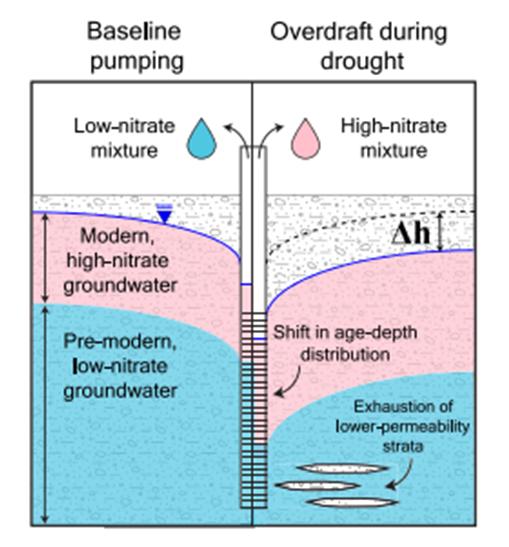
Water Quality Degradation. Recent research has found that lowering groundwater levels may also be related to regional water quality degradation. The United States Geological Survey Water Science Center indicates that lowering groundwater levels accelerate nitrate contamination of supply wells in the Central Valley5 by drawing down the water table closer to supply well screens, as shown in Figure 6. Drought conditions and declining groundwater levels can also deteriorate groundwater quality by concentrating contaminants or inducing deeper (or coastal) brackish groundwater to move into the productive zones in aquifers. Shift from Surface Water Supply to Groundwater. Growers and irrigation water districts are currently faced with unprecedented water supply challenges. Surface water supplies that rely on Central Valley Project, State Water Project, and Colorado River deliveries are seeing supplies dwindle. This year, the Bureau of Reclamation announced a 0% allocation for the Central Valley Project for irrigation districts and 25% for cities. Similarly, State Water Project allocations were slashed from 15% at the start of the year to 5% in spring. Due to its senior water rights on the Colorado River, the state has not seen curtailments on Colorado River deliveries; however, with Lake Mead at critical water levels, continued declines may trigger cutbacks on California deliveries, impacting municipal and agricultural users across Southern California.
With uncertainty surrounding surface water supply, many growers have been forced to turn exclusively to groundwater to meet their crop demands, or alternatively fallow their fields. According to the U.S. Department of Agriculture, an estimated 531,00 farmland acres went unplanted this year due to lack of water.6

State Actions to Manage Drought Conditions. The bright side of historic drought for groundwater managers, is that drought related issues have the full attention of DWR and the governor’s office. The following summarize key measures taken to manage the drought, mitigate its impacts, and provide relief across the state:

• Over the last three years, state leaders have earmarked $8 billion to modernize water infrastructure and management, which enabled emergency drought response as well as projects by local and state agencies to address current and future droughts impacts and to become more resilient. As of October 3, 2022, DWR has provided over $480 million in grant funding through its Small Community and Urban and Multi-benefit Drought Relief programs. This summer, the Legislature approved hundreds of millions in additional funding and programs to support water stressed communities.7
• During the current drought, Governor Newsom has issued several drought emergency proclamations that direct DWR and other agencies to actively respond to the current conditions. Drought proclamations have called agencies to implement actions to provide drinking water assistance, local well permitting coordination, and regulatory relief of groundwater recharge projects under specified circumstances to mitigate drought impacts. Governor Newsom has asked all Californians to reduce water usage at home by 15%.
• The governor issued Executive Order N-7-22, which requires that new well permits to consider sustainable groundwater conditions in the basin, and ensure that new wells do not decrease the likelihood of achieving groundwater sustainability goals, interfere with production of existing wells, or cause additional subsidence.
• Residents with dry wells can get help from a state program that provides bottled water as well as storage tanks regularly filled by water delivery trucks. The state also provides money to replace dry wells, but there’s a long wait to get a new one.
The benefits of SGMA and the associated GSPs are being put to the test as projects and management actions are being funded and implemented. Filling data gaps and improved monitoring will help to quantify the groundwater impacts of drought. Hopefully, the financial investments and lessons learned from this exceptional drought will make groundwater basins more resilient to the extended and pervasive drought conditions that appear to be the new normal.


https://tableau.cnra.ca.gov/t/DWR_SGM/views/
Endnotes:
1 https://data.cnra.ca.gov/dataset/californias-groundwater-semi-annual-conditionsupdates/resource/7e57614f-9868-4d2e-bbb80621be558b9c


2 https://water.ca.gov/Current-Conditions
3 https://agupubs.onlinelibrary.wiley.com/doi/ full/10.1029/2021WR031390
4 https://agupubs.onlinelibrary.wiley.com/doi/ full/10.1029/2021WR031390
5 https://cawaterlibrary.net/wp-content/ uploads/2021/09/Levy-et-al.pdf
6 https://apnews.com/article/californiadroughts-climate-and-environmente49c8c5c34ead7ef7f83b770082f20bc
7 https://water.ca.gov/News/NewsReleases/2022/Oct-22/New-Water-Year-BeginsAmid-Preparations-for-Continued-Drought
The California State Water Resources Control Board (Water Boards) is soliciting Statement of Qualifications (SOQ) from firms that are able to provide groundwater basin studies in support of state intervention pursuant to the Sustainable Groundwater Management Act (SGMA). The Request for Qualifications (RFQ) is open to all eligible firms and/or individuals that meet the minimum qualification requirements. The Water Boards intends to make a single contract award. The Contractor will be selected based on written responses to RFQ No. 22-002-240, plus an oral interview. The RFQ No. 22-002-240 will be advertised by the end of January 2023. Once the RFQ is posted and available, to view the time schedule, proposal requirements, and minimum qualification requirements for this solicitation, please visit http://www.caleprocure.ca.gov. For questions, comments, and inquiries regarding this solicitation, please review the RFQ No. 22-002-240 for the instructions and submission deadlines.
The Water Boards would like to thank you in advance for your interest in our service needs. The bidding process is the mainstay of our competitive system, and your participation is both appreciated and valued.
Overview of DWR’s Statewide AEM Surveys Project
This article is the first in a series of four HydroVisions articles that provides basic information, answers general questions, and connects the reader to more detailed information online about the California Department of Water Resources’ (DWR’s) Airborne Electromagnetic Surveys (AEM Project) This work was initiated in 2021 and will be completed in 2024 and is being funded through Proposition 68 Funding. Visit the AEM Project webpage for more information: https://water.ca.gov/ Programs/SGMA/AEM.

This first article provides a high-level overview of the AEM Project and subsequent articles include:
• Spring 2023: How Does AEM Work and What are the Applications? Getting into the weeds on the technical details
• Summer 2023: How Does AEM Improve Management of Groundwater? Case Studies from Denmark and other States in the US.
• Fall 2023: How can AEM Improve Management of Groundwater in California and the US? A Case Study in California
So with that, let’s dive in!
AEM is a geophysical method that measures the electrical resistivity of subsurface materials from either airplane or helicopter-mounted equipment. In this article, AEM refers to a helicopter-mounted system named SkyTEM, which has been used in the statewide project. The AEM sensor is housed in a large frame that is hung beneath the helicopter (Figure 1). A strong electric current, generated in the transmitter loop, is abruptly turned off to induce an eddy current in the ground, which generates a secondary electromagnetic field. The earth response is measured in a receiver coil mounted on the frame. The measured response is related to the electrical resistivity of the subsurface materials. Typically, materials that are electrically conductive are interpreted as fine-grained materials, like silts and clays, or can be interpreted as water with high salinity. Materials that are electrically resistive are interpreted as coarse-grained materials, like sands and gravels, and rocks as shown in Figures 2, 3, and 4. The helicopter flies at a groundspeed of 80-100 kilometers per hour (50-60 mph) carrying the equipment approximately 30 meters (100 feet) above the ground surface and collects data along a pre-defined flight path. Flight paths are developed in coordination with local Groundwater Sustainability Agencies (GSAs) and are designed to collect data over open spaces in a coarsely-spaced grid, with a line spacing of approximately 3 by 13 kilometers (2 by 8 miles). The AEM data are interpreted to show the distribution of coarse-grained and fine-grained materials in the subsurface, which improves the understanding of aquifer structures.
You will find all article figures and endnotes at the end of the article.
DWR is required by the California Water Code to investigate the groundwater basins in the State and has a long history of basin characterization and reporting this information through California’s Groundwater Bulletin 118. This project builds on that tradition by utilizing new and innovative technology that is providing state and federal agencies, GSAs, interested entities, and the public with basin-specific and cross-basin geophysical data, tools, and analysis aligned to the technical requirements of SGMA and regulations for groundwater sustainability plans (GSPs). The resulting information will provide a standardized, statewide dataset that will improve the understanding of large-scale aquifer structures, which aids in the development or refinement of a hydrogeologic conceptual model and identification of possible recharge areas. AEM data will support the development and refinement of groundwater models, improve the potential for the successful implementation of GSPs, and reduce uncertainty in identifying locations of structural features such as the Corcoran Clay or areas of high salinity. The coarse-grid AEM data also serve as the basis for the collection of fine-grid AEM data by local, state, and federal agencies in the future.

DWR is collecting AEM data in all of California’s high- and medium-priority groundwater basins, where data collection is feasible. AEM data collection started in 2021 and will continue through 2023. Table 1 provides the AEM Survey Schedule and Figure 5 is a Survey Location Map. Figure 6 shows the survey lines of AEM data collected to-date.
How is the data and information being made available to the public?
DWR publishes all project related data reports and datasets on the California Natural Resources Agency Open Data Portal (https://data.cnra.ca.gov/dataset/aem). Data reports describe how AEM data were collected, processed, and inverted and provide an interpretation of each lithology. Datasets include AEM data at each stage of the process (raw, processed, inverted, and interpreted) and supporting data (newly digitized lithology and geophysical logs). Reports and datasets are published on a rolling-basis for each Survey Area as tasks are completed by the contracting team.
In addition, DWR develops tools and maps to help the general public view the data. DWR’s most recent data visualization tool is the AEM Data Viewer. This online, GIS-based tool displays AEM data in a three-dimensional space and allows the user to view the data from various angles and to zoom in/ out. The tool can be accessed on a computer or mobile phone and does not require data to be downloaded or the use of specialized software. The AEM Data Viewer can be accessed here: https://data.cnra.ca.gov/dataset/aem/resource/29c4478dfc34-44ab-a373-7d484afa38e8.
The next article, coming in Spring 2023, will provide details on the AEM method and will answer the following questions: how are data collected? How are data processed? Once processed, what is involved in correlating the AEM models to a large number of lithologic and geophysical logs? What is the uncertainty of the interpretation of subsurface conditions from AEM data and how is uncertainty determined? What actions can local or regional agencies take to utilize AEM data to improve basin understanding?
Endnotes:
1 California professional geologist (PG) and certified hydrogeologist (CHg) with GEI Consultants and task order manager for AEM Project
2 PG with GEI Consultants and technical lead on compiling supporting data for AEM Project
3 PG and CHg with Ramboll and lead reviewer for AEM Project
4 Geophysicist with Ramboll, Lead Geophysicist and Project Director for AEM Project
5 PhD and Senior Geophysicist with Ramboll

6 PhD, PG and Statewide AEM Survey Project Manager, DWR Sustainable Groundwater Management Act (SGMA) Office
7 PG and Technical Assistance Section Manager, DWR SGMA Office
8 PE and Data Support Section Manager, DWR SGMA Office
9 PG, CHg, and Policy and Technical Advisor to the Deputy Director, DWR SGMA Office
Salinas Valley, Cuyama Valley
August 2021
Lassen and Modoc Counties
Southern San Joaquin Valley
November 2021
November 2021 #3 Napa and Sonoma Counties
March 2022
Middle San Joaquin Valley
Northern Sacramento Valley, Redding Area, Eel River
Gilroy, Santa Cruz, and Salinas Areas

April 2022
April 2022 #6 Northern San Joaquin Valley and Southern Sacramento Valley
May 2022
November 2022

Figure 3 – An example of AEM resistivity cross section from the Cuyama Valley. The location map of the section within the survey area is provided in the top panel and the resistivity profile along the section line is the bottom panel. Well lithologic logs near the section are projected on the section. The warm and cool colors show high and low resistivity values, respectively. All AEM data collected within the Cuyama Valley can be viewed on the online AEM Data Viewer.

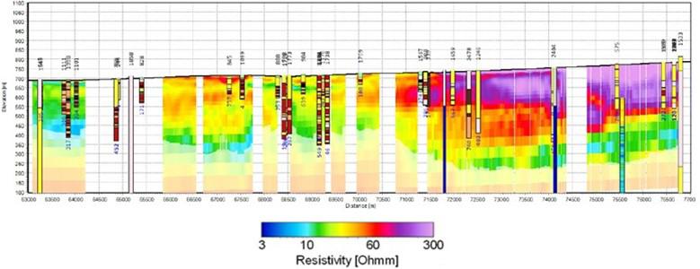
Texture Model Fence Diagram The AEM resistivity models are compared with lithologic descriptions from wells to determine the coarse materials (sand and gravel) where water is stored and can easily flow, and fine materials (silt and clay) that inhibit groundwater flow.


 by Dan Bryant, Rob Wilhelm, Roohi Toosi, and Jim Strandberg
In previous HydroVisions, GRA’s voluntary technical experts noted the continuing state and federal efforts to regulate Perand Polyfluoroalkyl Substances (PFAS). This article discusses a recent proposed ruling by the United States Environmental Protection Agency (USEPA) and its potential implications.
On August 26, 2022, the USEPA proposed to designate two of the most studied PFAS compounds, perfluorooctanoic acid (PFOA) and perfluorooctane sulfonic acid (PFOS), as hazardous substances under the Comprehensive Environmental Response, Compensation, and Liability Act (CERCLA). This is the first time that USEPA utilized its authority under CERCLA to add compounds to the current list of about 800 hazardous substances under 40 Code of Federal Regulation (CFR) Section 302.4. The public comment period ended on November 7, 2022, and USEPA is anticipating adoption by August 2023. This designation provides a mechanism for USEPA to mandate action, including assessment and remediation, at sites potentially impacted by PFAS.
Listing a compound as a hazardous substance under CERCLA has very different implications than the previous listing of a compound as a Hazardous Waste under the Resource Conservation and Recovery Act (RCRA), a Pollutant under the Clean Water Act (CWA), or a Contaminant under the Safe Drinking Water Act (SDWA). Listing as a CERCLA hazardous substance has both direct and indirect effects. The direct effects are limited: (i) if one pound or more of PFOA or PFOS is discharged in a 24-hour period, then reporting to USEPA and other agencies is required and (ii) transportation of PFOA and PFOS will need to meet specific US Department of Transportation requirements. These direct effects are limited because PFOA and PFOS are no longer manufactured nor widely found in commerce today in the United States.
The most significant implications of the hazardous substance listing are indirect, and are derived from the Response Authorities identified in the CERCLA regulation:
42 U.S. Code § 9604(a)(1) “Whenever…any hazardous substance is released or there is a substantial threat of such a release…the President is authorized…to remove or arrange for the removal of…such hazardous substance…at any time… or take any other response measure…”
Thus, unlike listings under RCRA, SDWA, or CWA, there are no numeric criteria (such as a concentration, mass discharged, etc.) that define when USEPA can or cannot mandate investigation or remediation. The USEPA simply needs to know or suspect there may have been a release or believes there is a threat of a release, to require assessment and other responses. Thus, once a substance is classified as a hazardous substance under CERCLA, USEPA will have broad latitude to mandate responses at a wide variety of sites, including industrial and commercial facilities as well as wastewater treatment plants and other municipal facilities. Sites that are or were previously designated as Superfund sites can also be subject to additional review for PFOA and PFOS contamination. If PFAS is found, these sites can be re-opened for investigation, existing remedies may require modification, and remediation cost attribution may be renegotiated between parties that the USEPA determines are responsible for the contamination. Responsible parties can be forced to reimburse the USEPA if the agency undertakes the remediation under the CERCLA designation.

The USEPA has indicated that it will likely prioritize large industrial facilities and sites where Aqueous Film Forming Foam (AFFF) fire suppressants were released. During a webinar on October 25, 2022 (available at https://youtu. be/4S1wxAP4nZI?t=3055), USEPA Region 2 Deputy Administrator Walter Mugdan said, “There is no exemption in the law that would protect let’s say a wastewater treatment plant that has received PFAS in the sewage that gets...into surface water somewhere.” But he added that USEPA will likely focus on major PFAS releases when evaluating sites for placement on the Superfund National Priorities List (NPL), making the prospects for water treatment facilities being identified as responsible parties for cleanups as highly unlikely. However, Mugdan added, “But there’s no legal ‘get out of jail free’ card here.”
The PFAS CERCLA designation is anticipated to have significant financial impacts on companies with legacy PFOA and PFOS contamination issues. Some of these industries, including water utilities and waste management companies, are already pursuing PFAS CERCLA exemptions from USEPA and it is expected that many legal challenges will be filed against the USEPA designation. Whether through direct enforcement action, re-opener remediation actions, or lawsuits for contribution, the costs for site cleanup are projected to be up to a billion dollars per year for existing non-Federal Superfund sites and for “new” sites plus reopened sites.
In November 2021, ASTM International (ASTM) updated its standard ASTM 1527-13 for Phase I Environmental Site Assessment (ESA), which among other things, included an assessment for emerging contaminants and particularly PFAS. On March 14, 2022, USEPA published a Direct Final Rule that confirmed the new ASTM E1527-21 could be used to satisfy USEPA’s All Appropriate Inquiry (AAI), as defined in 40 CFR 312. However, not long after, on May 2, 2022, USEPA withdraw the Final Rule to address the negative comments received on this rulemaking, including the United States Chamber of Commerce objection to the inclusion of PFAS in ASTM E1527 Standard Practice. The proposed USEPA CERCLA PFAS hazardous substance designation would require that Phase I ESAs, conducted pursuant to the ASTM E1527 Standard Practice and USEPA’s AAI Rule, include an assessment of whether PFAS compounds have ever been stored, used, or manufactured at a property, and, whether they may have potentially impacted the property. Presently, since PFAS compounds have not been designated as CERCLAlisted hazardous substances, the ASTM E1527 Standard Practice and the AAI Rule do not require an assessment of PFAS in the scope of a Phase I ESA. If and when the USEPA’s proposed CERCLA PFAS hazardous substance designation is adopted, questions remain as to how this designation will affect real estate transactions currently using the ASTM152713 Standard Practice and AAI Rule for qualification as Bona Fide Prospective Purchasers after this designation. Caveat emptor…let the buyer beware, appears particularly relevant in this situation when evaluating whether a property is a source of or affected by releases of PFAS to the environment and the potential for CERCLA liability. The challenges associated with assessing PFAS in property transactions further highlights some of the implications of this proposed rulemaking.


Regulators interviewed for this article said it is too early to assess the implications of USEPA’s proposed designation of PFOA or PFOS as CERCLA hazardous substances. There will be uncertainties until the rule is final. There is no focus currently to drive the investigation and remediation of PFAS sites. It was noted that an analytical test method for analysis of non-potable water has yet to be approved, although USEPA Draft Method 1633 is published and pending review and approval. Rather, the more immediate issue is the anticipated release of draft Maximum Contaminant Level (MCL) Goals for PFOA and PFOS, originally scheduled by December 31, 2022. It is unclear if USEPA will release MCLs by December 31, 2023, as planned.
On November 10, 2022, California’s Attorney General filed a lawsuit against more than a dozen companies seeking damages for PFAS contamination throughout the state. The lawsuit targets PFAS manufacturers, PFAS distributors, and AFFF manufacturers and suppliers and alleges that they “created and/or contributed to a public nuisance, harmed and destroyed natural resources, marketed defective products, failed to provide adequate warnings concerning the use of their products, and engaged in unlawful business practices.” The complaint seeks damages for contamination associated with seven of the thousands of PFAS compounds, including PFOA and PFOS. Damages sought by California include past, present, and future costs to investigative and remediate PFAS contamination, including the proper disposal of PFAS wastes. The proposed USEPA PFAS CERCLA hazardous substance designation will likely bolster California’s lawsuit and propel similar actions by other states and entities seeking damages for PFAS contamination.
Gra and acwa* are Proud to Present a new and iMProVed sGMa iMPleMentation suMMit!
*presented by the ACWA Groundwater Committee and the GRA SGMA Implementation Subcommittee
This is a once-a-year GSA and stakeholder get-together to foster progress on SGMA implementation, collaborating with ACWA members and implementers and GRA technical experts.
Format:
• One full day of interactive panels
• Reverse panel with DWR/SWRCB leaders
• Guided lunch discussions
• Evening social with tables representing different areas in the state to network and discuss location-specific challenges
Additional: Optional ½ day workshop on conflict resolution training and approaches
Key Topics:
• GSP 5-Year Updates – requirements and expectations, including need for revised climate change analysis
• Demand management as a complementary tool to supply augmentation – creative approaches
• Inter-connected surface water and depletions, upcoming requirements and state framing (GSP compliance and tools) ------And more!

This is YOUR Summit – come prepared to get the most out of it!
On June 7th & 8th 2023, don’t miss this opportunity to share and mingle with other SGMA practitioners!
For more information or if interested in participating/ providing input/leading a conversation, reach out to: Lisa Porta (lporta@elmontgomery.com), Adam Hutchinson (ahutchinson@ocwd.com)

In Part 8 (Fall 2022 HydroVisions) of this series, I described fluoride minerals and mineral solubility in some worldwide occurrences, particularly in granitic terranes. However, fluoride also occurs in surface water and groundwater in areas having past and current volcanic activity because fluoride is generally enriched in volcanic gases and geothermal fluids. The most common gases associated with active volcanoes (in general decreasing abundance) are water vapor or steam (H2O) – constituting approximately 50% to 90% of all eruption gases, carbon dioxide (CO2; 1-40%), sulfur dioxide (SO2; 1-25%), hydrogen sulfide (H2S; 1-10%), hydrogen (H2), helium (He), carbon monoxide (CO), and hydrochloric (HCl) and nitric (HNO3) acid (Brunning, 2018). Lesser amounts of other gases may also be emitted, including argon (Ar), fluorine (F), hydrofluoric acid (HF), nitrogen (N), carbonyl sulfide (COS), carbon disulfide (CS2), hydrogen bromide (HBr), ammonia (NH3) and native elements [e.g., sulfur (S), boron (B), and gold (Au) and volatile metals: mercury (Hg) and selenium (Se)]. Generally, H and CO rapidly oxidize to H2O and CO2, respectively, and H2S oxidizes to sulfurous (H2SO3) and/or sulfuric (H2SO4) acids, but volatile sulfur may also result in direct condensates, sublimates, or encrustations as native sulfur deposits. Chlorine monoxide (ClO) may also form when HCl is oxidized and HF can condense in rain or on ash particles (McGee and Gerlach, 1995 and McGee, et al., 1996).
Generally, most volcanic gases rarely reach or impact populated areas in lethal concentrations because of rapid atmospheric oxidation and solubilization in water vapor. One study showed that lethal effects are quite low ~10 km downwind from a volcano. Usually, such hazards are restricted to surrounding volcanic vents and fumaroles and to low spots on the volcanoes’ flanks. In such areas, volcanic gases (e.g., CO2, HF, and SO2) may be harmful to humans, animals, plants and crops, and property (e.g., utility lines, farm equipment, vehicles, and metal objects, which corrode when exposed to gases or acid rain). Exposure to acid gases (e.g., H2SO4, HCl, and HF) can damage eyes, mucous membranes, respiratory systems, and, under extreme conditions, can lead to death. The different volcanic gases affect the earth, people and animals in different ways and health hazards can range from minor to life-threatening, particularly for people with chronic respiratory and/or heart disease. Fluorine gas and HF can condense in rain or on ash particles coating grass, polluting streams and lakes with excess fluorine, eventually impacting groundwater. Animals eating fluorine-tainted, ash-coated grass may be poisoned. Although small amounts of fluorine can be beneficial, excess fluorine causes fluorosis by destroying teeth and bones, including humans when fluorine is leached into domestic water supplies (Hansell, et al. 2006; Motzer, 2014).

You will find all article figures and endnotes at the end of the article.
One such area is the alkaline volcanic province of the East African Rift Zone (EARZ) or valley, encompassing and extending through Eritrea, Djibouti, Ethiopia, Kenya, Tanzania, Uganda, Rwanda, Burundi and Malawi (Figure 1). The EARZ contains some of the highest recorded world-wide fluoride concentrations in surface water and in groundwater with fluoride exceeding the World Health Organization’s (WHO) drinking water permissible level of 1.5 mg/L. Because fluoride occurs in hot springs, alkaline lakes, some river systems, and groundwater, it’s routinely consumed by the populous, resulting in severe dental and skeletal fluorosis (Malago, et al., 2017; Motzer, 2017).
The source for most of this anomalous fluoride is attributed to the EARZ hyper-alkaline volcanic rocks, including sodium and calcium rich magmas and intrusions such as nepheline syenites and carbonatite magmas and their associated volcanic ash deposits. Large fluoride concentrations [e.g., in the minerals villiaumite (NaF) and fluorite (CaF2)] are often contained in these melts and their associated volatile fractions with water bodies subsequently accumulating fluoride from rock weathering, leaching of fine-grained and friable volcanic ashes, and from high fluoride in geothermal waters. The weathering of fluoride-containing minerals and other silicates in the lavas and ashes by silicate-hydrolysis reactions commonly results in a sodium-bicarbonate-rich groundwater depleted in calcium and magnesium. Therefore, fluoride can occur in high concentrations because fluorite solubility is not a limiting factor (Brindha and Elango, 2011; Motzer, 2017).
One of the most extensive surveys of EARZ water sources was done in Ethiopia, which has an estimated population (as of December 2022) of ~121.9 million people. From analyses of 1,438 samples of surface water and groundwater, this study found that 24% of all water sources exceeded the WHO permissible level with 50% of deep wells and 90% of hot spring samples exceeding the WHO permissible level. Areas along the Awash River were the most affected where sugar plantations had attracted large settlements. The long-term use of deep groundwater from wells has resulted in high rates of both dental and skeletal fluorosis (Motzer, 2017).

References
Brinha, K and Elango, L., 2011, Fluoride in Groundwater: Causes, Implications and Mitigation Measures, in, S.D. Monroy (editor), Fluoride Properties, Applications and Environmental Management: Nova Publishers, Hauppauge, NY, pp. 111-136.
Brunning, A. 2018, Lava and Volcanic Gases: Periodic Graphics: Chemical & Engineering News: www.cenm.ag/periodicgraphics
Hansell, A.L., Horwell, C.J., and Oppenheimer, C., 2006, The Health Hazards of Volcanoes and Geothermal Areas: Occupational & Environmental Medicine, v. 63, n. 2, pp. 149-156, https://www.ncbi. nlm.nih.gov/pmc/articles/PMC2078062/.

Malago, J., Makoba, E., and Muzuka, A.N.N., 2017, Fluoride Levels in Surface and Groundwater in Africa: A Review: American Journal of Water Science and Engineering, v. 3, n. 1, pp.1-17.
McGee, K.A and Gerlach, T.M., 1995, Volcanic Gas in Volcanic Hazards Fact Sheet: U.S. Geological Survey.
McGee, K.A., Doukas, M.P., Kessler, R., and Gerlach, T.M., 1997, Impacts of Volcanic Gases on Climate, the Environment, and People: U.S. Geological Survey Open-File Report 97-262,
Motzer, W.E., 2014, Volcanic Violence – Part 2 (Volcanic Gases): The Vortex, v. LXXV, n. 5, pp.5-6 www.calacs.org
Motzer, W.E., 2017, Toxic Terra – Part 8 (Fluoride): The Vortex, v. LXXIX, n. 1, pp.6-7 www.calacs.org
U.S. Geological Survey, 1999, East Africa Rift Zone map: https:// pubs.usgs.gov/gip/dynamic/East_Africa.html
Figure 1: Schematic showing large, explosive volcanic eruptions that inject water vapor (H2O), CO2, SO2, HCl, HF, and ash (pulverized rock and pumice) to stratospheric heights of 1020 miles (16-32 km) above the Earth’s surface. Most HCl and HF are dissolved in water droplets in the eruption cloud, quickly falling to the surface as acid rain. Source: McGee and Gerlach (1995).

Figure 2: Map of the East Africa Rift showing some historically active volcanoes (red triangles) and the Afar Triangle (shaded at the center). Source: U.S. Geological Survey (1999)
https://pubs.usgs.gov/gip/ dynamic/East_Africa.html.

The Morro Bay estuary is a 2,300-acre semi-enclosed body of water. The estuary encompasses the lower reaches of Chorro and Los Osos creeks, a wide range of wetlands, salt and freshwater marshes, intertidal mud flats, eelgrass beds, and other subtidal habitats. Morro Bay hosts one of the most significant and least disturbed wetland systems along the central California coast about halfway between San Francisco and Los Angeles. The bay is also an important stop on the Pacific Flyway, providing seasonal feeding grounds for more than a hundred species of migratory birds.
Morro Rock at the entrance to Morro Bay is a State Historic Landmark. For over 400 years, Morro Rock has been an important navigational aid for mariners because it’s a prominent coastal landmark at 576 feet tall.
Morro Rock is a 24-million-year-old rhyolitic volcanic plug and is located at the western end of a chain of fourteen aligned volcanic plugs that extend southeast from Morro Bay through the city of San Luis Obispo (16 miles). The volcanic plugs were probably intruded along a complex fault system in the region, which provided a preferential pathway for the rising magma.
The Morro Bay National Estuary Program works to protect and restore the Morro Bay estuary for people and wildlife. The Estuary Program is a collaborative, non-regulatory, nonprofit organization that brings citizens, local governments, nonprofit organizations, state and federal agencies, and landowners together to support a healthy environment and vibrant local communities. Their Comprehensive Conservation and Management Plan (CCMP) defines the priority issues for the Morro Bay estuary and watershed and includes action plans to effectively address those issues. The 2022 CCMP priority issues include: accelerated sedimentation, bacterial contamination, elevated nutrient levels, toxic pollutants, scarce freshwater resources, preserving biodiversity, and environmentally balanced uses.
Photographed by John Karachewski, PhD, on February 5, 2022. Photograph taken at the El Moro Elfin Forest in Los Osos at 35.332626° and -120.830200°. The Elfin Forest includes a 0.8-mile boardwalk loop that provides wheelchair access and protects the Forest’s sensitive habitat. Other recreational activities in the greater Morro Bay region include biking, bird watching, boating, camping, fishing, hiking, kayaking, and water sports.


Abigail Madrone
Abigail Madrone is the Business Development Director at West Yost Associates, a consulting engineering firm that specializes in water, groundwater, wastewater, and stormwater planning, design, and construction management projects. Abigail has over 15 years of professional experience in client services, marketing, business development and project management. Ms. Madrone received a Bachelor of Science degree in Managerial Economics with an emphasis in Agricultural and Resource Economics from the University of California, Davis. Abigail is the San Francisco Bay Area Branch Scholarship Chair and serves on various committees. Ms. Madrone is also the Immediate Past President of Northern California Professional Environmental Marketing Association.
David W. Abbott, P.G., C.Hg., Consulting Geologist
David W. Abbott, P.G., C.Hg., Consulting Geologist, is a Geologist with 45+ years of applied experience in the exploration and development of groundwater supplies; well location services; installation and design of water supply wells; watershed studies; contamination investigations; geotechnical and groundwater problem solving; and protection of groundwater resources.
Chris Bonds, Sacramento Branch Member at Large
Pete Dennehy
Pete Dennehy, PG, CHg, is a hydrogeologist at Montgomery and Associates in Sacramento. He specializes in hydrogeologic investigations for sustainable groundwater resources management and water supply.
Abhishek Singh
Dr. Abhishek Singh is a Principal Engineer with more than 20 years of experience and is President of INTERA’s Water Resources & Supply Line of Business (LoB), where he leads and manages operations, business development, strategic planning for the lob across the United States. He has authored several technical publications and journal articles on groundwater modeling and calibration, stochastic optimization techniques, uncertainty and risk analysis, climate change, and emerging contaminants. Dr. Singh is also the chair of the GRA technical committee and serves on the GRA board of directors.
Azita Asadi
Azita Assadi, P. Geo. (Canada) is a technical committee member at the GRAC. She is a Hydrogeologist with over 20 years of consulting experience in water resources and soil/groundwater management in the US, Canada, and internationally. She is currently working as a Geologist at A-Tech Consulting Inc. in the field of subsurface investigation and water resources management.
Chris Petersen
California professional geologist (PG) and certified hydrogeologist (CHg) with GEI Consultants and task order manager for AEM Project
Julián Consoli
PG with GEI Consultants and technical lead on compiling supporting data for AEM Project
Timothy Parker
PG and CHg with Ramboll and lead reviewer for AEM Project
Max Halkjaer
Geophysicist with Ramboll, Lead Geophysicist and Project Director for AEM Project
Ahmad Behroozmand
PhD and Senior Geophysicist with Ramboll
Katherine Dlubac
PhD, PG and Statewide AEM Survey Project Manager, DWR Sustainable Groundwater Management Act (SGMA) Office
Steven Springhorn
PG and Technical Assistance Section Manager, DWR SGMA Office
Benjamin Brezing
PE and Data Support Section Manager, DWR SGMA Office
Timothy Godwin
PG, CHg, and Policy and Technical Advisor to the Deputy Director, DWR SGMA Office
Dan Bryant
Woodard & Curran
Rob Wilhelm TetraTech
Roohi Toosi, Apex Environmental and Water Resources
Jim Strandberg
Jim Strandberg is a Senior Hydrogeologist/Project Manager at Woodard & Curran in Walnut Creek, CA. Jim is a member of the firm’s national emerging contaminants team and leads PFAS projects across the state.
William E. (Bill) Motzer
William E. (Bill) Motzer, PHD, PG, CHG, is a somewhat retired Forensic Geochemist
John Karachewski, PhD
John Karachewski is a geologist for the California EPA (DTSC) in Berkeley. He is an avid photographer and often teaches geology as an instructor and field trip leader.


