A RESOURCE FOR MUNICIPALITIES, LANDOWNERS, ORGANIZATIONS AND INDIVIDUALS
SEPTEMBER 2013
PREPARED BY PREPARED FOR
ACKNOWLEDGEMENTS
Rensselaer Plateau Alliance Board of Directors
Rachel Riemann Akera
Jim Bonesteel
Fred DeMay
Jim de Waal Malefyt
Francille Egbert
Contributors
Richard Gibbs
Shari Gibbs
Alice Howard
Lawrence Howard
Lisa Hoyt
Michael Welti, AICP – Behan Planning and Design
John Behan, AICP – Behan Planning and Design
Rick Lederer-Barnes – Behan Planning and Design
Brian Zweig, MBA – Business Opportunities Management Consulting
Sarah Parks, Ph. D. – Amala Consulting
Dr. David Hunt – Ecological Intuition & Medicine
Rachel Riemann Akera
David Hunt
Walter Kersch
Yvonne Keefe
Stephen Pentak
Robert Stegemann
Karen Strong – Hudson River Estuary Biodiversity Program Coordinator, NYS Department of Environmental Conservation in partnership with Cornell University
Francille Egbert
Additional Thanks to:
Dale Blanchet
Warren Broderick
Nick Conrad
Ellen Crane
Tim Holt
Tim Howard
Tom Phillips
Dan Yacobellis
Steve Young
Marybeth Pettit
Nate Simms (for many of the photos)
And thank you to all of the local officials and residents who participated in the public outreach process
This Project has been funded in part by a grant from the New York State Environmental Protection Fund through the Hudson River Estuary Program of the New York State Department of Environmental Conservation.
Additional funding provided by the Hudson River Valley Greenway and by the Open Space Institute.
Friends of Dyken Pond served as a fiscal sponsor for this project
Appendix
Appendix
Appendix
Appendix
LIST OF MAPS, CHARTS, AND TABLES
Maps
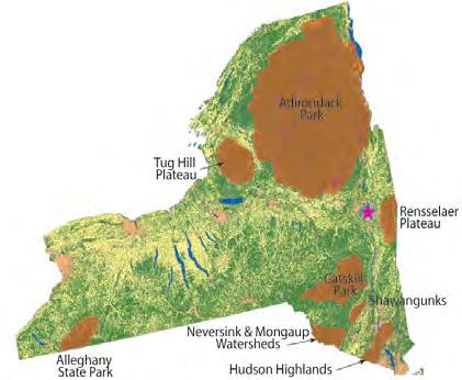
Large Forested Areas in New York State Page 4
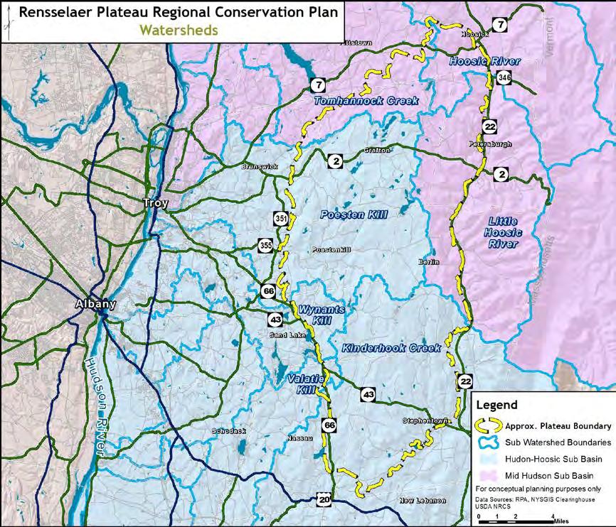
Watersheds Page 4
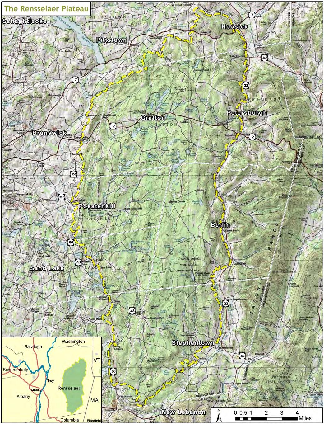
The Rensselaer Plateau (Topographic overview) Page 6
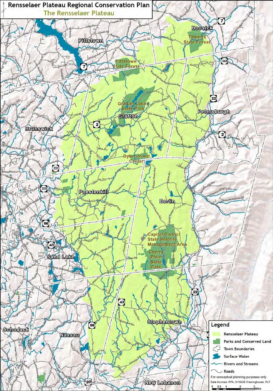
The Rensselaer Plateau (general overview) Page 7
Population Change 2000 to 2010 Page 18
Housing Unit Change 2000 to 2010 Page 19
Land Cover Classifications Page 21
Protected and Regulated Lands Page 22
Significant Natural Areas of the Rensselaer Plateau After Page 24
Community Values Summary Page 35
Figure 1 – Large Forest Blocks Appendix A
Figure 2 - Forest-Interior Habitat Appendix A
Figure 3 – Important Aquatic Networks Appendix A
Figure 4 – Important Ecosystem Complexes Appendix A
Figure 5 – Rare Plants of the Rensselaer Plateau Appendix A Charts
Land use percentages on the Rensselaer Plateau Page 17
National Land Cover Database land cover percentages on the Rensselaer Plateau Page 20
Annual Value by Land Cover Type and Ecosystem Service Type Page 33 Tables
Table 1. Recognition of the ecological significance of the Rensselaer Plateau Page 23
Table 3. Community Values of the Rensselaer Plateau Page 36
Table A1. Ecological Communities/Natural Communities of the Rensselaer Plateau Appendix A
Table A2. County, State, and Globally Rare Plants of the Rensselaer Plateau Appendix A
Table A3. Preliminary List of Rare Animal Species on the Rensselaer Plateau Appendix A
I. INTRODUCTION
What is the Rensselaer Plateau?
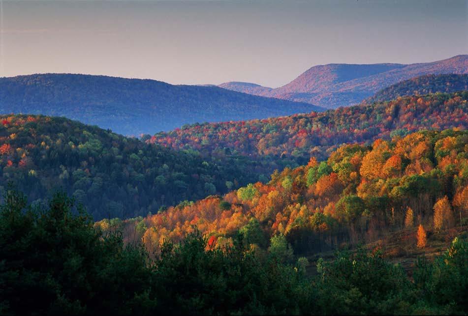
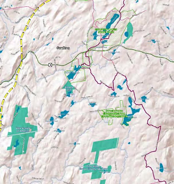
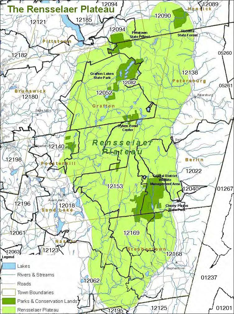
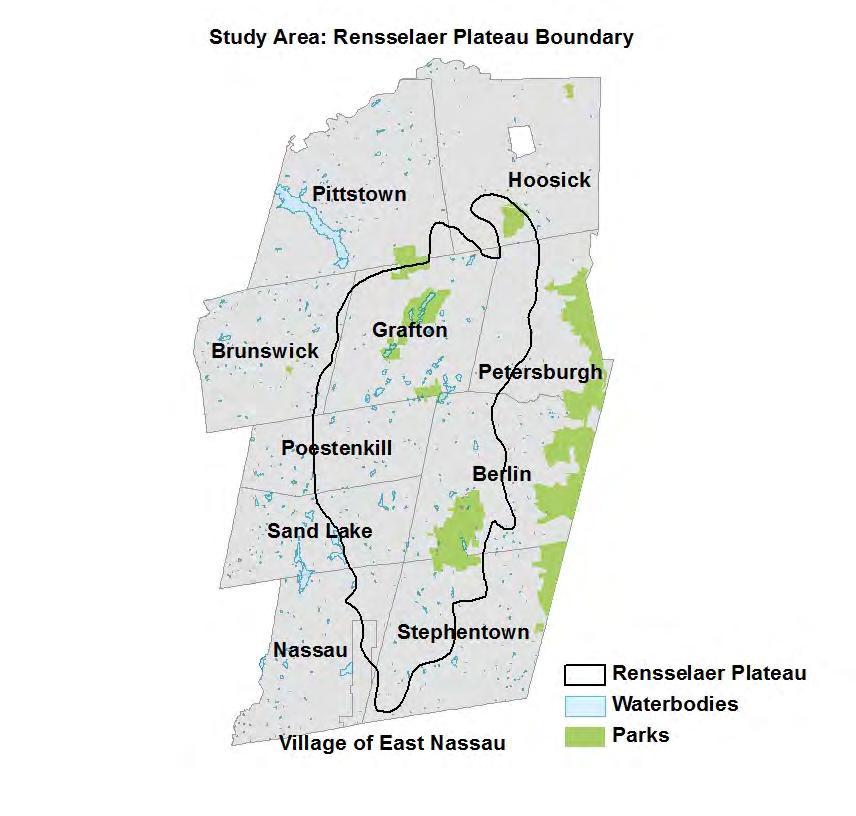
The Rensselaer Plateau is located in the eastern portion of Rensselaer County in New York State, less than 30 minutes from downtown Albany. The Plateau extends across portions of the Towns of Berlin, Brunswick, Grafton, Hoosick, Nassau, Petersburgh, Pittstown, Poestenkill, Sand Lake, Stephentown and the Village of East Nassau [See map on following page].
The Rensselaer Plateau is a geologically distinct upland region –a true plateau. An escarpment steeply rising from the surrounding lower elevations marks its boundary. The Plateau’s relatively high elevations (1,000 –1,800 feet) and cool climate, acidic soils, and its poor drainage contribute to plants, forests, and wetlands more similar to New York’s Northern Forest than to the surrounding local area.
At approximately 118,000 acres the Rensselaer Plateau is the 5th largest forested region in the state. Its forests still exist in relatively large continuous blocks with few dividing roads. The natural resources of the Plateau are valuable for providing clean air, clean water, stormwater handling, and healthy habitat for many native plants and wildlife. Its forests contain the headwaters of seven watersheds, all which ultimately end up in the Hudson River. Four drain into the Hudson River Estuary below the Troy Dam. Three of the northeast sections drain into the Hoosick River then into the Hudson River in Stillwater. Other waters feed the Tomhannock Reservoir (the public water supply for the City of Troy and much of Rensselaer County).
The 2009 NYS Open Space Conservation Plan includes the Rensselaer Plateau as a Regional Priority Conservation Project and states:
This area of Rensselaer County includes the fifth largest unfragmented forest in New York State and a portion of the Tomhannock Reservoir Watershed, which provides water to over 100,000 County residents. In addition to the expansive forest, the Plateau supports several unique wetland communities (including sedge meadow, dwarf shrub bog, spruce-fir swamp, and kettle hole bog), an impressive mammal diversity not typical of the greater Capital District (including black bear, fisher, otter, bobcat, and moose), and is included on National Audubon Society's list of Important Bird Areas in New York, which specifically mentions a high diversity and abundance of forest breeders, including many state-listed species. Protection activities in this area would not only serve to secure these significant features, but would also contribute to a longterm vision shared by a number of organizations to establish an open space corridor and trail system across the Plateau; connecting Dyken Pond Center to Grafton Lakes State Park, Pittstown State Forest, Capital District Wildlife Management Area, Dickinson Hill Fire Tower, and other recreation and environmental education facilities. [page 88]
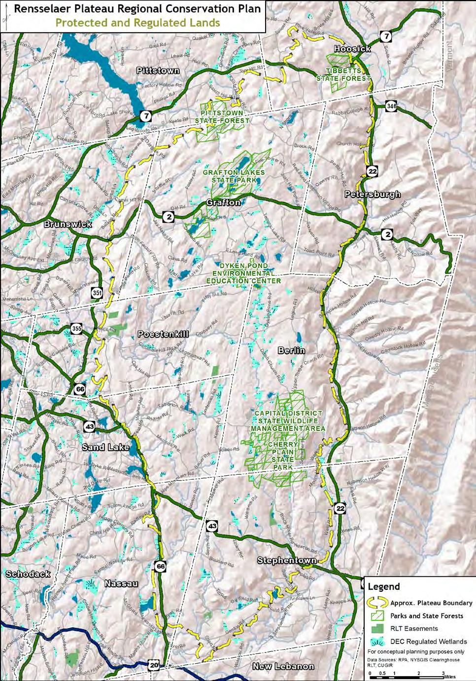
In December 2010, the Rensselaer Plateau was designated a Forest Legacy Area by the US Forest Service after being included in a new Assessment of Need by the NYS Department of Environmental Conservation (NYSDEC). The Rensselaer Plateau is also recognized as an significant biodiversity area in the Wildlife and Habitat Conservation Framework by NYSDEC’s Hudson River Estuary Program, and it is the focus of conservation efforts by the Rensselaer Land Trust, the Agricultural Stewardship Association, and other organizations.
The environmental resources on the Plateau were catalogued in an extensive ecological assessment developed as part of this plan. Ecological features across the Plateau - such as large forest blocks, important ecological systems, stream networks, natural communities, rare plants, forest interiors, and connecting corridors – have been systematically identified and mapped using Geographic Information System (GIS). More information about the ecological assessment is provided in Section II under the subsection entitled “The Plateau Today.”
In addition to its environmental value, the Rensselaer Plateau provides significant economic value to communities both on and off the Plateau. A 2012 economic study prepared for the Rensselaer Plateau Alliance as part of the development of the Regional Conservation Plan, demonstrates the economic impact of several industries on the Plateau, including: forest products (over $9 million annually and approximately 100 jobs), food services and drinking places (almost $4 million annually and approximately 110 jobs), and tourism and recreation (about $3 million annually and over 80 jobs). In addition, an analysis of the economic value of ecosystem services - such as clean water, pollination, disturbance prevention, etc. - on the Rensselaer Plateau estimates the total value of ecosystem services at approximately $300 million per year. More information about the economic study is provided in Section II under the subsection entitled “The Plateau Today.”
Who is the Rensselaer Plateau Alliance?
The Rensselaer Plateau Alliance (RPA) is a diverse group of organizations and people who live on or near the Plateau with interests to conserve the qualities and character of this region and the benefits it provides. The RPA seeks to work cooperatively with municipalities, groups, and residents to help educate and promote actions that protect the environmental and economic values provided by the Plateau for the long term.
The RPA has been meeting since May 2006. Started as a group of interested people representing landowners, local organizations, and recreational users, the RPA was incorporated as a New York State not-for-profit corporation in October 2008 and received 501(c)(3) tax exempt determination in November 2009. Normal business meetings are and have always been open to the public. Meeting times, dates, and locations can be found on the RPA’s website: www.rensselaerplateau.org.
As of this writing (March 2013), the RPA has 29 alliance member organizations including the very large and very small and ranging from recreational groups such as horseback riding, cycling and snowmobile clubs to sportsman clubs, lake associations, forest owner association and environmental organizations.
The RPA’s mission is to:
Promote and facilitate the protection of the Rensselaer Plateau’s undeveloped and unfragmented forests. These possess many significant natural features and provide natural habitats for plants and animals, forest products, recreation and most important, water and air quality.
To that end, the RPA focuses on building broad support and consensus over a wide geographic area. Having been asked numerous times over the years to speak out against specific projects on the Plateau (a wind project here, a development there), the RPA has always respectfully declined. Instead, the volunteer members of the RPA strive to bring the various stakeholders on the Plateau together and to provide information about the Plateau’s multiple values and the ways that these values can be conserved for future generations. The organization has been successful in adding new members and, with very little overhead, utilizing member contributions toward the accomplishment of its mission. It has also been able to secure grant
INTRODUCTION
funding from public agencies and private foundations in support of its work. This has allowed the RPA to tackle larger projects such as this Regional Conservation Plan, the Working Forest Initiative, and the area’s first Forest Legacy grant application on behalf of interested landowners on the Plateau.
What is the purpose of this Regional Conservation Plan?
The purpose of the Rensselaer Plateau Regional Conservation Plan is to:
• Elevate the broad public understanding of the Plateau as a unique and culturally valuable county, state and regional resource
• Identify the most significant ecological, economic, and community values
• Identify conservation and stewardship needs for those areas
• Create a toolbox the stakeholders of the Rensselaer Plateau region can use to ensure the long term viability of most significant ecological, economic, and community values
It is intended that the Regional Conservation Plan will provide information that can be used to guide decision-making by landowners, municipalities, and organizations or agencies that have an interest in the Rensselaer Plateau.
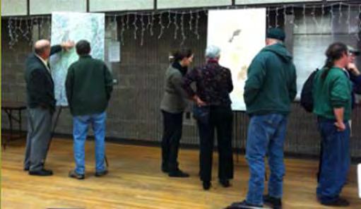
How was the community involved in the development of this plan?
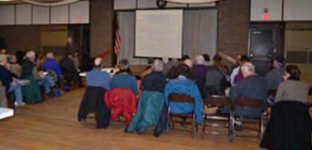
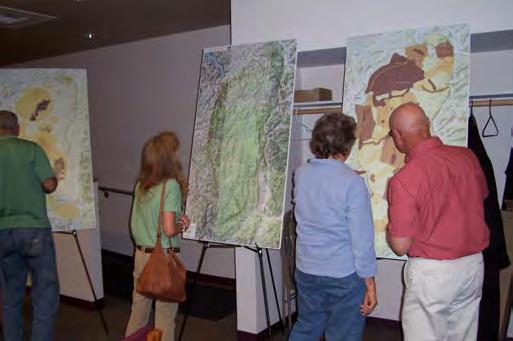
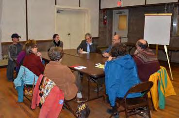
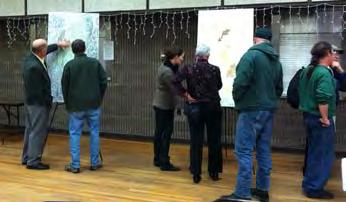
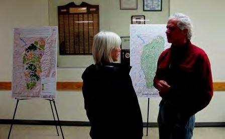
Development of the Regional Conservation Plan included several opportunities for community involvement, including three public workshops conducted over several months. The purposes of these workshops were as follows:
Public Workshop #1 – December 6, 2011 in Poestenkill
• Introduce the project to the community
• Review outcomes of previous public meetings and community values forums
• Review progress on the inventory and analysis
• Engage participants in discussion about expectations for and concerns about the idea of a “regional conservation plan” for the Plateau
Public Workshop #2 – April 30, 2012 in Averill Park
• Update - What have we learned about the Plateau’s natural areas and economic importance?
• Present some initial ideas for the Regional Conservation Plan
• Engage participants in a discussion about the initial ideas that are under consideration
Public Workshop #3 – March 21, 2013 in Grafton
• Review the Draft Regional Conservation Plan
• Engage participants in a discussion about the draft plan – receive comments and suggestions for consideration as we prepare a final version of the Regional Conservation Plan
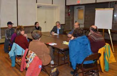
In addition to the public workshops, several smaller stakeholder meetings were held to discuss particular aspects of the plan. Stakeholder groups are listed below.
Stakeholder Meetings - May and June 2012
• Large landowners
• Local officials
• Forestry / forest products industry
• Alliance member organizations
Meeting notes from all of the public workshops and stakeholder meetings are included in Appendix C.
II. THE RENSSELAER PLATEAU – PAST AND PRESENT
A Brief History of the Plateau
Prepared
by: Francille Egbert
What makes the Rensselaer Plateau unique, what reminds you of the Northern Forest, what makes it feel wild, what makes it feel old and well lived in? The answers to these questions bring us a richer understanding of the landscape we hike, ride through, swim in or live on.
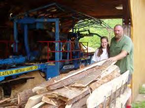
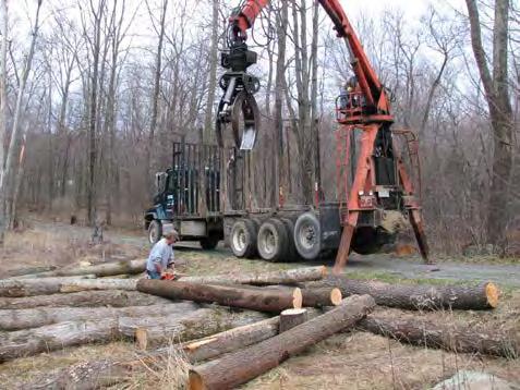
The rocks that form the Rensselaer Plateau originated about 505 million years ago, long before humans, or any land animals, inhabited the earth. Greywacke, a poorly sorted but weatheringresistant type of sandstone comprises much of the bedrock of the 118,000 acres of the forested plateau. It is the resistance of the Rensselaer Formation, as the greywacke is locally known, to weathering that accounts for the high elevation of the plateau relative to the Hudson Valley region to the west. The greywacke originally was deposited in a deep ocean trench that was sandwiched between the land mass of proto-North America and an arc of volcanic islands located offshore. During the assembly of the last supercontinent, Pangaea, the ocean between proto-North America and the island arc closed, causing the rocks once in the ocean trench to be broken into a series of roughly horizontal slices and stacked on top of each other at the edge of the North American coastline. The collision resulted in the creation of the Taconic Mountains, about 440 million years ago. Although the Rensselaer Formation is part of the oldest of the slices of rocks in the Taconic s, the older and deeper greywacke layer was shuffled to be above younger layers in the area we now know as the Rensselaer Plateau. Over millions of years, rain, wind, and ice eroded the Taconic Mountains into what we know today as the Taconic Ridge and the Rensselaer Plateau. The greywacke that underlies the plateau is an important economic resource in eastern New York. Crushed, it makes high quality, abrasion resistant construction aggregate widely used in high-speed road surfaces.
Vast sheets of ice inundated nearly all of New York several times in the last 2 million years, reshaping the landscape to some extent. Most of the natural lakes and ponds on the Plateau formed 14,000 to 12,000 years ago as the last ice sheet retreated, where the ice had scoured out basins in the bedrock or had deposited sediment that partially blocked pre-glacial valleys. In a very few places, streams of meltwater from the melting ice deposited small terraces of sand and gravel. In some small headwater valleys, visitors often hear water gurgling even though no stream is visible; close examination reveals that water is flowing just below land surface along the valley axis, amid a band of cobbles that may have been a product of temporary meltwater across saddles and along small valleys during deglaciation. The Plateau landscape supported predominantly low vegetation for a while after the ice retreated, but spruce, popular and balsam fir trees soon migrated into the region, followed by eastern hemlock, white pine and later deciduous trees such as maple, beech, birch and oak.
The Mohican was the Native American tribe occupying the Rensselaer Plateau when European immigrants first arrived. The Mohicans lived most of the year along the Hudson River with its rich sources of food. But Mohican territory extended from Dutchess County to Lake Champlain and from the Housatonic River to present Schenectady. Stone cairns, platforms and enclosures found on the Plateau are thought by some authorities to have been built by Mohicans. They used this large territory for
hunting, moving northeast toward Vermont to hunt moose in the winter. “Owning” would be the wrong word to describe their relationship to the Plateau: “a Mohican speaker expressed the common native feeling about land when he explained that the Indians regarded land as a gift from the Great Spirit to their ancestors.” [1]
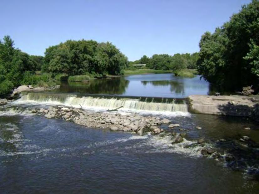
Mohicans hunted a land where the headwaters of seven different creeks create deep ravines and gorges such as the gorge along Plank Road. Here the Poesten Kill drops 92 feet forming the Barberville Falls, one of the unique treasures of the Plateau that can still be seen from the Nature Conservancy Preserve. These rocky ravines in deep shade are still home to many species of mosses, liverworts and lichens. Most of the soil on the Plateau is poor derived from the weathering of glacial till consisting of shale, sandstone and slate. However, small areas on the Plateau having limestone or dolomite develop a rich soil resulting in rare wildflowers such as the blue cohosh. Kettle holes and tannic ponds, the result of glacial melting, developed spongy peat along their shorelines, the results of thousands of years of plant growth and decay. Now they provide a unique habitat for unusual plants such as cranberries, pitcher plants and sundews. Many of these woods in which the Indians hunted centuries ago contain the same forest types today. The Mohicans faced continued competition with other native nations and their land was increasingly taken for homesteads by the Dutch and English. After the Revolution the Mohicans left this area for western New York and then Wisconsin.
In 1609 Henry Hudson sailed up the Hudson River to Troy. Going ashore he described the land along the Hudson River as “the finest for cultivation that I ever in my life set foot upon.” Not so the Plateau, however; settling on the Plateau was no easy feat! An 1890 Berlin resident speaking of his grandfather’s family experience recalled, “This howling wilderness was a poor market to look for stores for subsistence. Bears and deer and other game roamed in the forest. The brooks were alive with trout, but no time to take them.” [2] Early immigrants of the 1700’s many of them Dutch, German and New England Yankees were subject to the Dutch “patroon” system wherein they were leased land parcels and owed yearly rent to the Dutch patroon, Kiliaen Van Rensselaer. Not until 1839 did farmers making only a subsistence living conspire to bring an end to the feudal system of annual rents. Dr. Boughton, a resident of Alps on the southwestern edge of the Plateau, helped lead this “rent war” movement, which ended the patroon system. Farmers were finally able to own the land they may have worked for a century.
Logging (from Grafton Historical Society)
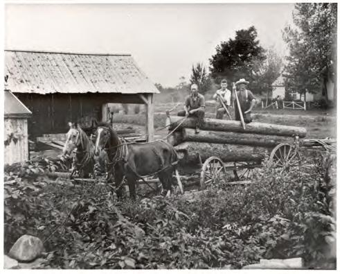
The first road on the Plateau, the Albany Road of 1753, crossed from Deerfield, MA to Greenbush, NY. But it wasn’t until peace returned after the Revolutionary War ended that the towns of the Plateau were established, between 1791 and 1812. Some of the oldest homes on the Plate au, built in 1780’s by settlers from New England, can still be seen on the Owen Road in Grafton. Despite poor soil, small family farms persisted, providing farm products for cheese factories, tanneries, and breweries. The forest provided lumber for mills.
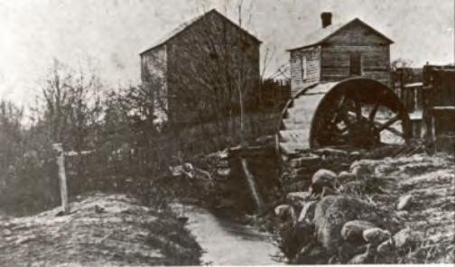
The farmers collected ferns and club mosses, gathered bark from cherry trees for medicinal use and from hemlock for tanning. The Plateau had many fast flowing streams and on almost every stream a mill was using water power in this fast growing area. Many of the lakes and ponds of the Plateau were changed dramatically by dams built at the turn of the century to provide reliable flowing water to the mills and industries of Troy. You can almost hear the rumble of bygone wagons at the mill site at the end of Mi ll Pond Trail in the Capital District Wildlife Management Area (CDWMA).
The dam that formed the millpond remains; an old cellar hole and wolf tree mark the clearing where roads converged on the mill. Small factories appeared in every town on the Plateau. Grafton had a shirt factory, folding chair factory, and a Prussian blue dye factory located on Blue Factory Hill Road, all in the 1800’s.Settlers found little prime farmland on the Plateau and a growing season shorter by 20 days than at lower elevations, but the shallow glacial till soil did support forest and that became an economic boon to the subsistence farmer. In the mid 1800’s immigrant Germans were recruited by the Glass Factory of Sand Lake to produce charcoal for the furnaces. Two families started the settlement in West Berlin in the 1830’s. Leaving their home in Bavaria, selling their possessions, land and home; they sought freedom to practice their religion and peace. They bought land on the Plateau for low cost woodlots to make charcoal and developed a close knit community to preserve their culture, religion and language. This community prospered for 70 years with school and churches maintaining these German traditions. Only when the charcoal business declined and young members of the community had to seek work in the lower village of Berlin did the isolated culture change with the last Annual “Deutsch Picnic” held in 1945.
Mill (from Stephentown Historical Society)
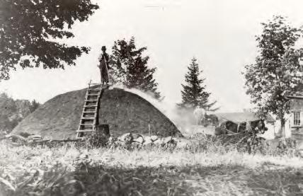
In the woods throughout the Plateau you can still discern the remains of charcoal pits, large fairly open circles 20-30’ in diameter with raised edges where charcoal can still be found within inches of the surface. Several nice examples can be found in the CDWMA near Cherry Plain State Park. This industry was primarily responsible for the removal of at least 70% of the trees on the Plateau by the 1890’s.
Troy was one of the industrial capitals of the world in the 1800’s and charcoal from the Plateau fueled its iron foundries. Thirty cords of wood were needed for a charcoal burn. Wood was cut and stacked in a circle to form a kiln which was covered with dirt, limiting air so the wood would burn slowly. The burn was tended day and night for days until the charcoal was formed. It was then sent by wagon to Sand Lake and into Troy.
Tibbitts State Forest holds the remnants of another historic industry, lime making. Limestone quarried on the Plateau near Babcock Lake Road in Grafton was burned in a kiln to form lime for use in agriculture and tanning. Remains of an old kiln can still be seen in the State Forest. Ice cutting of local ponds also supplemented a farmer’s income until refrigerators eliminated this as a source of income. With the building of the Erie Canal and the opening of the west, and with the deforestation of the Plateau, many folks left for more fertile western soils or employment in town. The Crash of 1929 and the Great Depression brought further change to the Plateau towns; businesses closed. In the 1930’s, coal replaced charcoal and subsistence farming alone could no longer feed families. With roads impassable in the snows of winter and the mud of spring, agriculture declined as workers sought higher paying jobs in Troy and Albany. Now a growing middle class in the county had money to support recreational pursuits.
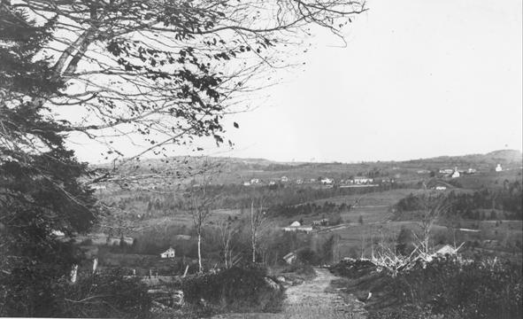
Deforested landscape looking toward Grafton, taken by James E. West
With many lakes and much open space, the Plateau now had cabins and hotels for tourism. Visitors spent time in hotels and camping, bathing and fishing in the fresh air and scenic environment. The Troy Record even sponsored a Fresh Air Camp for urban children in Grafton. Many lakeside communities were developed at this time with seasonal cottages for the wealthy to recreate in a cooler, greener place in the summer.
The working forest, environmentally and economically, made a significant recovery during the 20th century under the stewardship of Cowee and other lumber companies, and with little residential or road development on the Plateau. Forest fires were a concern during the early 1900’s, prompting the building of the Dickinson Hill fire tower in Grafton and the Seventh Hill fire tower in Stephentown. The Dickinson Hill fire tower was erected in 1924 and later manned by the first woman observer, Helen Ellett. The tower has been refurbished by the Friends of Grafton Lakes State Park and provides hikers with a spectacular 360-degree view including Mt. Marcy and the High Peaks, the Green Mountains of Vermont, the Berkshires and Taconics of Massachusetts, the Catskills in southern New York and the Helderberg Escarpment near Albany.
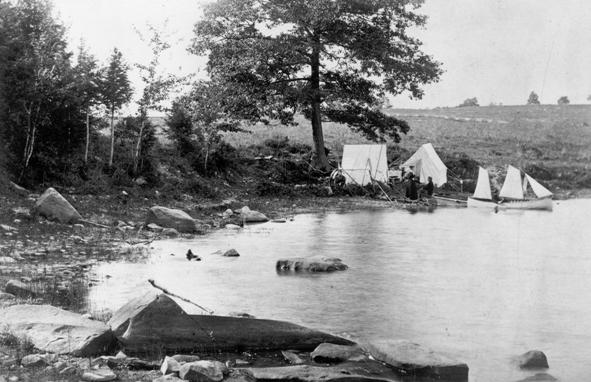
Camping on Shaver Pond, taken by James E. West
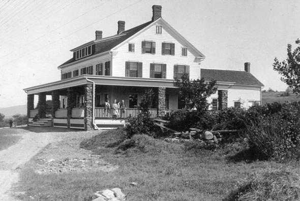
Fresh Air Home in Grafton, taken by James E. West
The Plateau landscape now holds this history of farms and mills in the many stone walls which once separated fields, cellar holes, dug wells, old lilac trees and sluice ways and mill ponds. Granville Hicks, political progressive from Grafton, celebrated the small plateau community in his book Small Town. After World War II, farms on the Plateau were abandoned when young men sought more money and shorter working days in industries along the Hudson River. Abandoned fields now returned to forests; only a few fields of high bush blueberries, previously an important cash crop, sti ll remained on the plateau. One can be seen at Grafton Lakes State Park.
Changing needs after World War II continued to bring change to the forests of the Plateau. Upgraded roads and interstate highways made the dream of a suburban home a reality for many families. Workers in Albany and Troy now make the daily commute to some communities on the Plateau. Despite these changes most of the forests are unbroken by roads and homes, providing the fifth largest forested area in NYS. Most of these large forested tracts remain in private ownership. In 2008 Cowee Forest Products, one of the largest landowners on the Plateau for a century, sold its land to the Forest Land Group, which maintains the conservation of this land through lumber production. Grafton Lakes and Cherry Plain State Parks, the Dyken Pond Environmental Education Center and state forests bring the public to the Plateau for hiking, swimming, biking and boating. However, these activities have not yet brought back jobs which were lost when small industries left. Small plateau communities are limited in employment, services and tax revenue.
As we look toward the future, will decisions of land use be able to maintain the special environmental features that make the Plateau unique while maintaining viable communities that have been home to many for generations?
Bibliography:
[1] Dunn, Shirley The Mohicans and Their Land 1609-1730, Purple Mountain Press, Fleischmanns, NY, 1994.
[2] Weise, AJ History of the Seventeen Towns of Rensselaer County JM Francis and Tucker, Troy, NY, 1880.
Bilven, Rachel and others, A Resourceful People: A Pictorial History of Rensselaer County, New York, The Donning Company, Norfolk Virginia 1987.
Broderick, Warren Images of America Grafton, Berlin, and Petersburgh, Arcadia Publishing, Charleston, SC, 2006
Poestenkill Historical Society, The Dutch Settlement Church, Poestenkill, New York, 1981.
Pictures by James E. West from the collection at the New York State Library Archives.
The Plateau Today
Understanding the Plateau’s past, and the changing ways that this landscape has been used over the years, is important for thinking about the future of this resource. For example, the fact that the forest was mostly gone 100 years ago is hard to imagine given the vastness of the forest today. And the historic uses of the Plateau demonstrate that it is not, and never has been, an isolated upland island. Its fate is tied to the region’s fate. Before we contemplate the future, it is also important to understand some things about the current state of the Rensselaer Plateau. This section of the plan provides some basic information about the Plateau today. In addition, summaries of the Ecological Report and the economic study conducted as part of this planning effort are provided below.
Population and land use of the Rensselaer Plateau
The population Rensselaer Plateau is growing faster than the rest of the county. In 2010, there were approximately 8,250 people living on the Rensselaer Plateau (US Census 2010). Which is about 7% more than in the 2000 census (refer to map -population change 2000-2010) and higher than the county’s growth rate of 4.5% over the same time period. Although growing more quickly than the county as a whole, the population is still low. The 8,250 people that live on the plateau are only 16% of the 51,474 people that live in Rensselaer Plateau towns.*
According to the census data there are approximately 4,070 housing units on the Plateau, roughly one housing unit per 25 acres. The maps on the following pages show the Year 2000-2010 change in population and the Year 2000-2010 change in housing units according to the census.
Based on 2009 parcel data, it is estimated that there are approximately 5,200 property owners on Plateau holding approximately 5,900 parcels of land. Of these owners, 150 of them own approximately one-half of the land on the Plateau. Fifteen owners account for a quarter of all the land ownership, and four owners control 20% of the total land area on the Plateau. The top four land owners, based on the parcel data, are:
• WJ Cowee, Inc (~9,800 ac.),
• State of New York (~8,500 ac.),
• Gundrum Lumber (~1,860 ac.), and
• Boy Scouts of America (~1,280 ac.).
WJ Cowee was purchased by the Garcia Group, Inc. of Atlanta, Georgia in late 2011. This property is now managed for lumber production by the Forest Land Group.
*The analyses presented on this, and the next few pages regarding population, land use and land cover and other demographic data are based on a 2006 Plateau boundary. In the process of completing this plan, an updated boundary was defined as depicted on the maps in the report. The updated boundary covers approximately 13,000 more acres than the 2006 boundary.
Note: As can be seen, the census blocks do not follow the 2006 boundary of the Plateau precisely, however blocks that extend off the Plateau tend to not have a high population, and those that extended beyond the boundary and appeared to have no homes within the Plateau were not included in the analysis. The census blocks cover an area approximately 7% larger than the 105,000 acre Plateau boundary.
Note the colored areas on the map denote census block boundaries, not official town planning boundaries. Also, the changes indicated by the legend colors are total numbers of residents and housing units, respectively, just within that particular census block. Some census blocks have negative growth for this 10-year comparison.
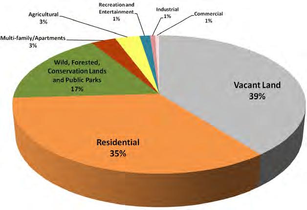
According to 2009 Real Property information approximately 39% of the parcel land area on the Plateau is classified as vacant land. The next largest category is residential, with 35% of the parcel area, followed by wild, forested, conservation lands and public parks with 17% of the parcel area. Multifamily and apartments and agriculture each account for 3%, with recreation and entertainment, industrial, and commercial with 1% each.
Looking at the more detailed land use categories, of which there are 57 on the Plateau greater than 10 acres, the top ten categories, by parcel land area, are rural residential (26,983 acres), vacant rural (24,773 acres), private forest (10,788 acres), rural vacant > 10 acres (10,320 acres), single-family residential (7,288 acres), S532B forest land (4,093 acres), rural vacant < 10 acres (3,397 acres), multiple residences (3,034 acres), state park (2,586 acres), and vacant with improvements (2,166 acres). Seasonal residences come in 12th with 1,779 acres, and dairy farms are 14th with 1,609 acres. It is important to remember that these are parcel acreages, and not the acreage of actual land use. For example a rural residential lot could be over 100 acres, however the improvements on the lot account for an acre or less of land disturbance with the remainder comprised of wild forest.
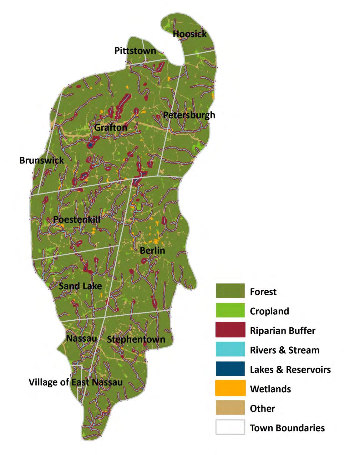
As indicated above, relying on real property data to get a picture of how the Plateau is being utilized is very difficult. Another method of looking at land use on the Plateau is the National Land Cover Database (NLCD). The NLCD is based on multi-spectral satellite data which has been classified based on standard land classifications. The most recent available data is from 2006, and indicates that approximately 90% of the Plateau is forested, and only approximately 3% is developed. The map on the following page shows land cover as determined by the NLCD. (The NLCD maps can be accessed on the RPA website in greater detail than in this report.)
More than 90% of the land on the Rensselaer Plateau is privately owned and about 10% is permanently protected from development. The State of New York is the second largest landowner on the P lateau (approx. 8,500 acres). For conservation purposes, this state land should be considered permanently protected. In addition, more than half of the Dyken Pond Environmental Education Center’s nearly 600 acres is owned by Rensselaer County, and an additional 486 acres on the Plateau have been protected by the Rensselaer Land Trust and other non- profit organizations. Some of the land is protected in fee, which means that the land is owned and managed by the state , county, or by a conservation organization. Other lands are protected by a conservation easement, which means the land is owned and managed by private landowners who have agreed to sell or donate the development rights to their land. A map of these “protected lands” follows the land cover map.
RENSSELAER PLATEAU – PAST AND PRESENT
Ecological Assessment
Prepared by: Dr. David Hunt with GIS assistance by Rachel Riemann and Sarah Parks
Summarized by: Karen Strong
The ecological significance of the Rensselaer Plateau is based on its large, connected forest. Large, forested areas like the Plateau once blanketed the Eastern United States, but after hundreds of years of clearing for agriculture and industry, these places are far less common. One of the reasons that the Plateau’s forests are so ecologically significant is that the landscape works for people and nature; many landowners have worked the land for generations and there continues to be very high quality ecological resources on the plateau. The forest’s ecological quality is threatened by conversion to nonforest uses and fragmentation of the forest into smaller pieces that are lower quality wildlife habitat and more difficult to manage from a sustainable forestry perspective.
The Plateau’s natural areas are considered ecologically significant because they have a high diversity of native plants and animals including wide ranging mammals and forest birds, relatively few invasive plants and animals, and they are large enough to be resilient to disturbance (Table 1). The Rensselaer Plateau is unique in the region because it is more similar to the Northern Forest (of Northern New York to Maine and into Canada), than it is to forests in the rest of the Hudson Valley.
Table 1. Recognition of the ecological significance of the Rensselaer Plateau Who What Why Reference
Audubon NY Important Bird Area –(Rensselaer Forest Tract); priority forest in Eastern Forest Project
NYSDEC Hudson River Estuary Program Significant Biodiversity Area (Rensselaer Plateau)
The Nature Conservancy
Ecoregional Priority sites: Central Rensselaer Plateau (Tier 1); Northern and Southern Plateau (Tier 2)
High diversity and abundance of forest birds of regional conservation concern (significant statewide and in Atlantic Flyway)
Large, unfragmented forest, unique wetland communities, mammal, and bird diversity, recreation and trails
Large, contiguous forest and wetland habitats and diverse plants, communities, and animals unique to this region
High quality and health of its large forest ecosystems
Important Bird Areas of New York (1997, 2004)
NYS Open Space Conservation Plan (2009)
Wildlife and Habitat Conservation Framework (2006)
Lower New England/Piedmont Ecoregional Plan: First iteration, edited (2003)
Although its overall ecological significance is well-known, there has never been a comprehensive accounting of the Rensselaer Plateau’s ecological resources. Characterizing and prioritizing the Plateau’s forests, wetlands, streams, and rare species can inform the region’s land use and land management decisions to help ensure the Plateau continues to be a functioning balance of nature and
people. Therefore, a detailed ecological assessment to map and characterize the most significant resources was completed as part of the Rensselaer Plateau Regional Conservation Plan. This ecological assessment will be useful well beyond prioritizing areas in this plan. The data used in the assessment are in a Geographic Information System (GIS), which is part of the toolbox that municipalities, landowners, others can use to inform decisions about land use or land management as well as guide future research on the Plateau. The GIS will be updated as more data is collected about the Plateau’s ecology.
Dr. David Hunt was commissioned to develop the ecological assessment of the Rensselaer Plateau. Dr. Hunt is an ecologist who has studied the Plateau’s natural areas for more than 20 years. He combined intensive field work, detailed air photo delineation, compilation of existing information, and consultation with experts to identify the most important natural areas on the Plateau. The ecological values described here can be combined with economic and social values for specific places on the Plateau, which can then inform land use planning and management decisions by municipalities, landowners, conservation organizations, and other plan users.
A summary of Dr. Hunt’s findings is provided below. Additional documentation from this study can be found in the maps and table of Appendix A as well as the full Ecological Report on the RPA website: www.rensselaerplateau.org.
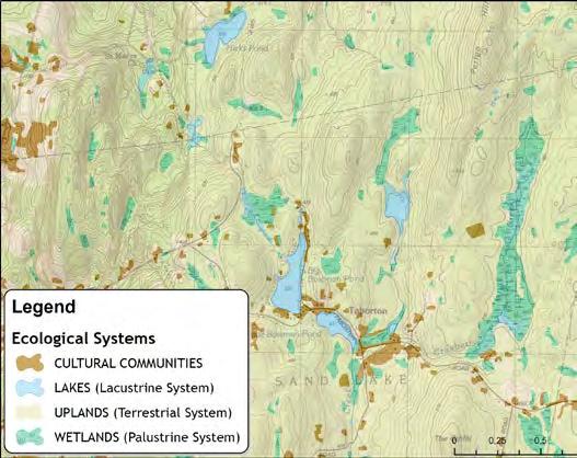
Significant Natural Areas of the
Rensselaer Plateau –
The ecological assessment of the Rensselaer Plateau revealed that most of its natural areas have high ecological value. The Significant Natural Areas of the Rensselaer Plateau map on the following page delineates natural areas based on the ecological resources of the plateau. The map also shows which of the areas have the highest ecological value based on an analysis of six ecological features: large forests and forest-interior habitat, significant natural communities, important ecosystem complexes, important aquatic networks, and rare plant habitat. Dr. Hunt weighed 17 factors to measure each site’s ecological value, including the rarity, size, condition/quality, and distribution of the six ecological features. Dr. Hunt has compiled descriptions of the most significant natural areas with description of the resources and management guidance that is included in the Ecological Report for the Conservation Plan.
The goal of identifying and prioritizing the significant natural areas is to inform conservation, stewardship, and management on the significant natural areas on the Rensselaer Plateau. The highest priority areas provide the best opportunity to protect the ecological resources of the Plateau given limited resources. The prioritization of significant natural areas can also help plan users manage lands to maintain ecological integrity.
The Wildlands and Woodlands Vision (http://www.wildlandsandwoodlands.org/vision/vision-newengland) is a useful framework to understand how the prioritization of significant natural areas can be used to guide management on the Plateau (see Table 2). It is a vision for maintaining a forested landscape where 90% of forests are “Woodlands,” conserved by willing landowners and sustainably managed for multiple uses, from recreation to wood products. In this vision only 10% of forests are
The entire Rensselaer Plateau is ecologically significant. This map shows which areas are most significant based on an analysis of six ecological features: large forests, forest-interior habitat, significant natural communities, important ecosystem complexes, important aquatic networks, and rare plant habitat. Dr. Hunt weighed 17 factors to measure each site's ecological priority, including the rarity, size, quality, and distribution of the six ecological features, and connections to other forested areas. From this, areas were further prioritized by selecting those areas that included the most important sites for each feature in the least amount of area. Natural areas with the highest resulting ecological priority on the Plateau are shown in orange. Water bodies that have a priority level different from their surroundings are shown with an outline in their priority color. A list of these highest ecological priority areas, and a description of each is included in the full Ecological Report. Areas that rank lowest on the Plateau are still important ecologically, but they do not have as many important features as other areas.
PAGE INTENTIONALLY LEFT BLANK
“Wildland” reserves, identified by local communities and shaped only by the natural environment. Table 2 applies this framework to the Significant Natural Areas map.
Table 2 Ecological Management recommendations for prioritized significant natural areas
Ecological Priority Value Description
7-8
5-6
2-4
Lowest priority natural areas; primarily buffer to higher priority resources
Moderate value natural areas; important connections to areas off the plateau and forest linkage to smaller scale features.
Moderately high to high value priority natural areas; includes key large forest blocks and natural communities, and important internal forest connections
Most compatible with Suggestions
Development, multiple use areas
Try to maintain forest cover, low-impact development approaches are ideal, but not critical.
Woodlands
1
Highest priority natural areas, include many overlapping high quality and uncommon ecological resources, irreplaceable
Woodlands
Manage as woodland with sustainable harvests; ecological resources can sustain clear cut areas, of several acres; suitable for low density residential development.
Wildlands
Manage as working forests with sustainable harvest methods that leave smaller gaps in the canopy and low road density. Disturbances should be located away from the most sensitive features.
Ideally no new development and roads and forest allowed to return to oldgrowth state. Sustain the forest and movement of water on the landscape (little to no wetland and stream alteration)
Building Blocks of the Ecological Assessment –
Dr. Hunt mapped and analyzed large forest blocks and forest-interior habitat, natural ecological communities, important aquatic networks, important ecosystem complexes, and rare plants and animals to identify the Significant Natural Areas of the Rensselaer Plateau. A brief description of these features, and a summary of how the information was collected, mapped and analyzed for the ecological assessment, is provided below. More detail and maps of these features are available in Appendix A and other supporting documents. Each of these resources will be helpful to guide conservation and management of ecological resources of the Plateau.
Large Forest Blocks and Forest-interior habitat:
The most significant forests of the Plateau can be described in two ways: large forest blocks bounded by roads and within those, areas of “forest interior,” or forested areas of high ecological integrity that are least influenced by roads and development. “Important” large forest blocks are larger than 1000 acres and have high quality natural vegetation and a low density of roads (see Appendix A or the Ecological Report for more detail on what forests were ranked “important”). “Important” forest interior areas included in the assessment are those that meet minimum standards for size and represent areas deemed most important for the animals and plants of a forested landscape including breeding forest-interior birds and large mammals. Combined, large forest blocks are the core of a forested region that supports landscape-level processes, (e.g., resilience to large-scale ecological disturbances like invasive species and climate change). Maps of these two ecological features ranked by size and condition can be found in Appendix A as Figure 1 and 2.
Natural Ecological Communities:
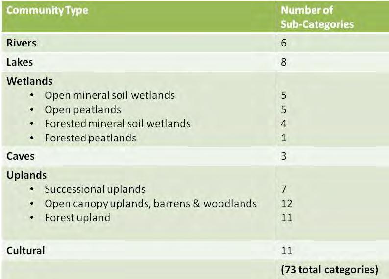
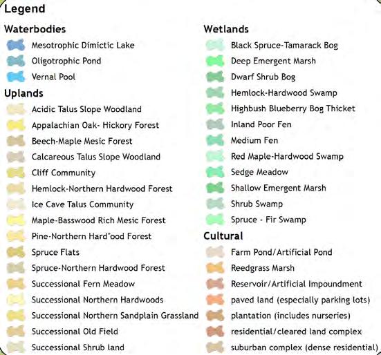
A natural ecological community is a group of plants and animals that share a common environment. Dr. Hunt mapped the natural communities on all 118,000 acres of the Rensselaer Plateau and found 73 of New York’s 174 community types described by NYSDEC (Table A1, Appendix A). The ecological communities fall into seven general types: upland forests, open uplands & barrens, wetlands, rivers, lakes, caves, and human-influenced. The most abundant upland forest types are hemlock-northern hardwood forest and beech-maple mesic forest. The edges of the Plateau (also called the escarpment) are
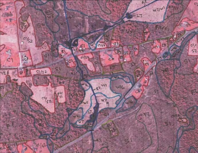
Dr. Hunt used intensive field study and air photo interpretation to create hand-drawn maps of the Plateau’s 73 ecological communities. These maps were then digitized so they could be used in the conservation plan and its toolbox.
steep and rocky, dominated by more Central Appalachian forest types with many rocky summits and talus slopes. Though the forest dominates the plateau, there are many smaller natural communities like red maple-hardwood swamp, dwarf shrub bog, and marsh headwater stream. The detailed natural community data will be useful resource for land stewardship, land management, and land- use planning and decision-making. A description, photo and management guidance for each community type can be found at www.guides.nynhp.org.
Because of the intact landscape and a unique mix of ecological communities on the Rensselaer Plateau, Dr. Hunt found many state significant community types, including those that are uncommon statewide or common communities that are high quality when compared to other examples in the county, state, and region. A globally rare community found was a sinkhole wetland found at Bentley’s Cave Preserve in Berlin. Rare ecological communities were generally found on the higher elevations of the central Plateau. Several community locations may be among the highest quality examples in the
Community type (above) and community type sub-catagories (below) for the same area of the plateau after data has been entered into the GIS.
eight-state Lower New England/Piedmont Ecoregion, and 37 of them are of the County’s highest quality examples in Rensselaer County.
Important Aquatic Networks:
Aquatic networks are continuous surface water systems linking stream, lakes, and wetlands with ecologically important adjacent areas like floodplains and stream corridors. The aquatic networks included in the assessment meet minimum standards for size and condition, and represent areas deemed most important for aquatic animals and plants. They are distributed across the five major watersheds and/or the central Plateau and escarpment (physiographic subdivisions - Figure 3).
Important Ecosystem Complexes:
Natural communities occurring together in the landscape can be aggregated into ecosystem complexes. Important ecosystem complexes are a concentration of important natural communities or likely to be important at the state- or regional level and are not well embedded in the largest forests Plateau, and thus were considered separately in the ecological assessment. The assessment identified 15 sites; primarily acidic wetland or peatland complexes on the central Plateau and rocky slope/summit complexes on the escarpment (Figure 4).
Rare Plants and Animals:
Rare plants and animals are included separately in the ecological analysis because they may not be covered by the larger ecological features. The rare plant mapping is complete. A known globally-rare vascular plant known from the Rensselaer Plateau is American Ginseng, a highly prized medicinal plant that has been reported from several sites. There are six state-rare plants that have been reported from the Rensselaer Plateau, four of which may no longer be found here. There are 116 County-rare vascular plant populations known from the Rensselaer Plateau as of January 2012. A complete rare species list (Table A2) and map (Figure 5) can be found in Appendix A.
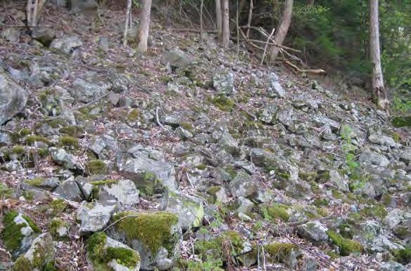
A talus slope woodland on Bear’s Head. These areas contain concentrations of denning areas for bobcat or porcupine
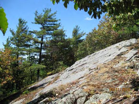
This rocky slope/summit complex on Bunker Hill is one of very few large areas on the Plateau containing exposed bedrock and open tree canopy.
Rare animal mapping is ongoing. Dr. Hunt has compiled a preliminary list of state and regionally rare animals that are known or suspected to live on the Plateau and found 19 state-rare animals that have current populations species of high conservation value, and several more that are known from historic records or unconfirmed reports (Table A3).
Conservation Status & Threats -
About 10% of the Rensselaer Plateau and its most significant natural areas are permanently protected from development; however, common forests of the central plateau are better protected than other ecological resources, like plateau escarpments and stream networks. But even the protected forested area is not enough to maintain the large areas of forest needed by the Plateau’s wildlife.
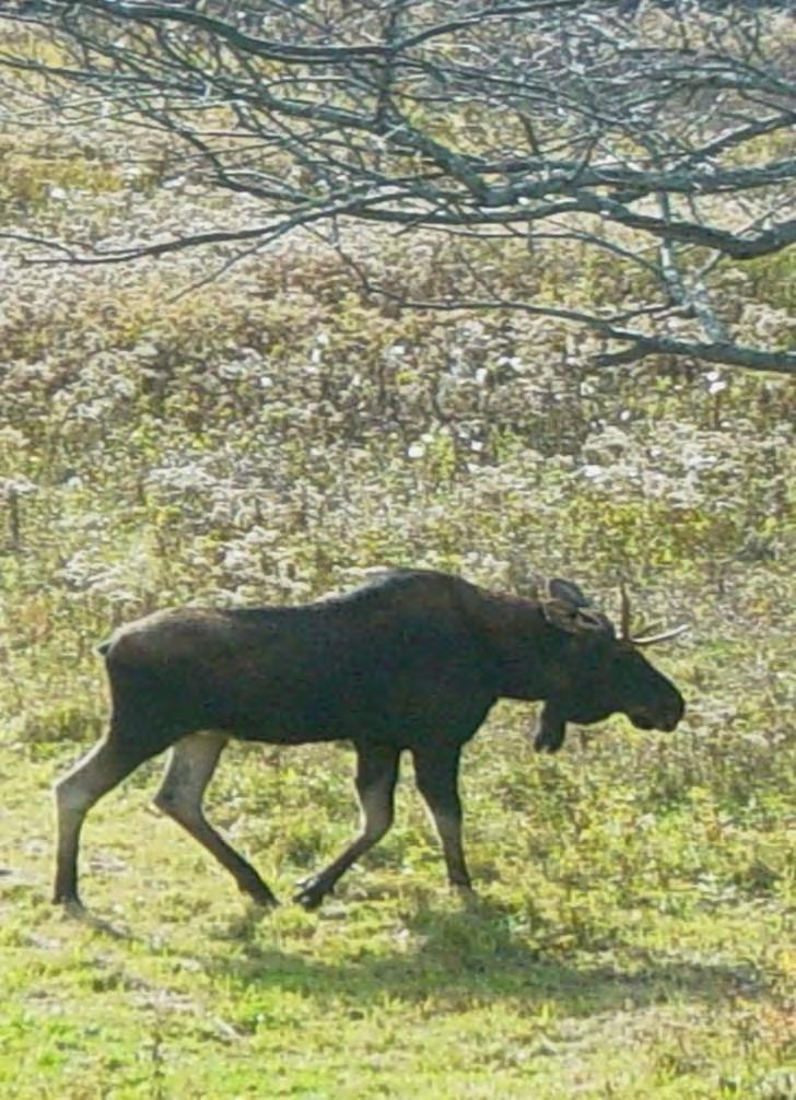
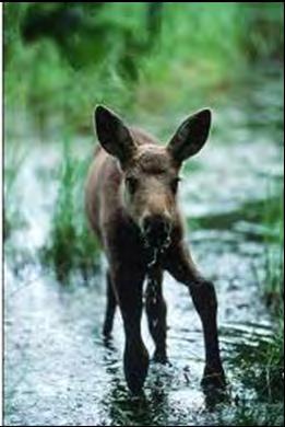
Contiguous forest is needed to sustain animals that require large acres of habitat with minimal human disturbance. For example, pairs of Northern Goshawks require extensive mature forests of 5,000 acres and nest more than 1,000 feet from human habitations and paved roads. Similarly, forest interior songbirds prefer contiguous forest habitat over 3,000 acres in size. A moose needs extensive forest habitat to find 40 to 60 pounds of browse daily and can range over one to 25 square miles of mixed forest and wetland habitat, depending on the season.
Natural areas and wildlife now depend on the stewardship of private landowners, and the continued quality of the Plateau will depend on how land is used and managed in the future. The current mix of land use and ownership has resulted in a sustainable landscape that works for people and wildlife,
Moose were nearly extirpated from New York State, but their population has grown in recent years. There is important year-round habitat for moose on the Rensselaer Plateau, which require large areas of forest.
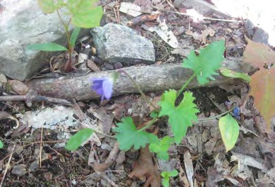
The Early Blue violet, a county-rare species, has been found on Snake Hill. This species falls into the rarest county-rare category in which only 1-5 sites are known in the county, and two of which are on Snake Hill. [note: this photo is from elsewhere in the county]
but loss and fragmentation of the forest may upset the balance.
From 1990 – 2010 the population increased 11.5% in Plateau towns as compared to only 2% in the whole county (US Census); and this trend is likely to continue as increased development is observed to occur at higher rates in amenity-rich areas such as the Rensselaer Plateau. Development increases stress on natural areas and systems. This pressure is increasing, especially near lakes and roads, due to the Plateau’s proximity to Albany, Schenectady, and Troy. For example, 46 new building lots on and near the shores of Dyken Pond in the last decade have substantially fragmented the second largest forest block on the Plateau.
Although habitat loss and fragmentation put the greatest pressure on the Plateau’s forests, they also face challenges from invasive plants and insects, higher temperatures and precipitation changes due to climate change.
People and nature have lived in relative balance on the Rensselaer Plateau for hundreds of years and the fundamental goal of the conservation plan is to make sure that continues to happen. The plan provides tools and strategies to help landowners, municipalities and others make decisions that will maintain that balance for future generations. With the information in th e Ecological Report and data , municipalities will have the information they need to reduce pressure on natural areas and wildlife and landowners will have information they can use to inform stewardship of their land.
Economic Study
In addition to learning more about the ecologic value of the Plateau, the Rensselaer Plateau Alliance wanted to know more about the economic value of the Plateau to our region. The RPA commissioned a separate Economic Study to complement and inform work on the Regional Conservation Plan. The Economic Study consisted of the following two component research studies:
• Impacts of Economic Activities – This includes estimating the direct and indirect economic contributions (income, employment) to the region resulting from various industries on the Plateau.
• Ecosystem Services / Non-Market (un-priced) Benefits – This includes estimating the value of benefits derived from ecosystem service such as clean water for drinking, storm water handling, clean air, etc.
These studies were designed to provide critical information about the contributions of the area’s natural resources to industry, tourism and recreation, as well as for less tangible values that these natural resources provide to residents of the Plateau and surrounding areas.
The executive summaries of both of these research studies are reproduced below. The full text of the Economic Study is attached to this report as Appendix B.
Economic Impact Study of Business Activities of the Rensselaer Plateau (May 2012)
Prepared by: Brian Zweig, MBA – Business Opportunities Management Consulting
[…]This economic study was conducted to help guide the Rensselaer Plateau Conservation Plan that is being developed by the Rensselaer Plateau Alliance, a group dedicated to the conservation of the Plateau for future generations. The study estimated and evaluated the economic contributions of specified industry sectors on the Rensselaer Plateau on the local economy of Rensselaer County.
Economic impact analyses were conducted using IMPLAN and the Money Generation models (MGM). IMPLAN is a software package and database for estimating local economic impacts, and is one of the most widely used and accepted methodologies available. The MGM models rely on the IMPLAN economic models and are used by the National Park Service to estimate the economic impact of tourism spending and park operations on local economies.
The economic impacts that were estimated included the number of jobs supported and the value added to the local economy as a result of the economic activity generated by each industry. The estimate of value added represents the sum total of increased value to goods and services that is generated by the local activities being evaluated and is the most commonly used measure of the impact of an industry to a region. Impacts include direct effects that accrue primarily to the industry itself, indirect effects that accrue to the suppliers of these businesses, and induced effects that result from household income produced by employees hired because of these businesses. The study estimated the following impacts for the selected industry sectors:
The results of the study show the forest products industry as having the largest dollar impact and also supporting a significant number of jobs. To the extent that forests can be re-grown, this is also a sustainable industry. The challenge of sustainable management is to harvest timber in ways that ensure that forests remain healthy, biologically diverse and productive for the future. Industry depends on the quality and productivity of commercial timberland. Selective cutting without a silvicultural basis often degrades future timber value thereby undermining the viability of both working forests and the timber industry. 1
The mining industry also has a significant dollar impact, but supports relatively few jobs. While the resources exist to expand mining on the Plateau, these resources are exhaustible and hence the mining industry is not sustainable long-term.
Agriculture is a sustainable industry, but soil and drainage conditions limit the potential for this industry on the Plateau.
Tourism and recreation has a significant impact on the Plateau, both in terms of dollars and jobs supported, due in large part to visitors of Grafton Lakes State Park. The lack of amenities for Plateau visitors, lodging establishments in particular, may be limiting the economic impact tourism and recreation on the local area. Potential opportunities for increasing the impact of tourism and recreation include improving available accommodations for visitors, increasing promotion of the Rensselaer Plateau as a tourist destination, creating a visitor information center and consideration of a NYS Scenic Byway Designation for the Route 2 and/or Route 22 Corridors.
The Economic Value of Ecosystem Services on the Rensselaer Plateau (May 2012)
Prepared by: Sarah Parks
Ecosystem services are the benefits people obtain either directly or indirectly from ecosystems. These services are essential to human well-being, as they provide a multitude of benefits such as clean
1 New York State Forest Resource Assessment page 153 available on line: http://www.dec.ny.gov/docs/lands_forests_pdf/fras070110.pdf
water, medicine, recreation, crop pollination and protection from natural hazards. Although these services are highly valuable, they often go unaccounted for in development or management decisions largely because they exist outside most current markets. Placing economic values on these non-marketed ecosystem services can help provide an understanding of the true value provided by natural resources for they really do save people from having to spend additional dollars for treating water, pollinating crops, and recovering from natural disasters, to name a few. The Rensselaer Plateau offers a multitude of ecosystem services, which significantly contribute to the human welfare of Rensselaer Plateau residents, Rensselaer County citizens, and others.
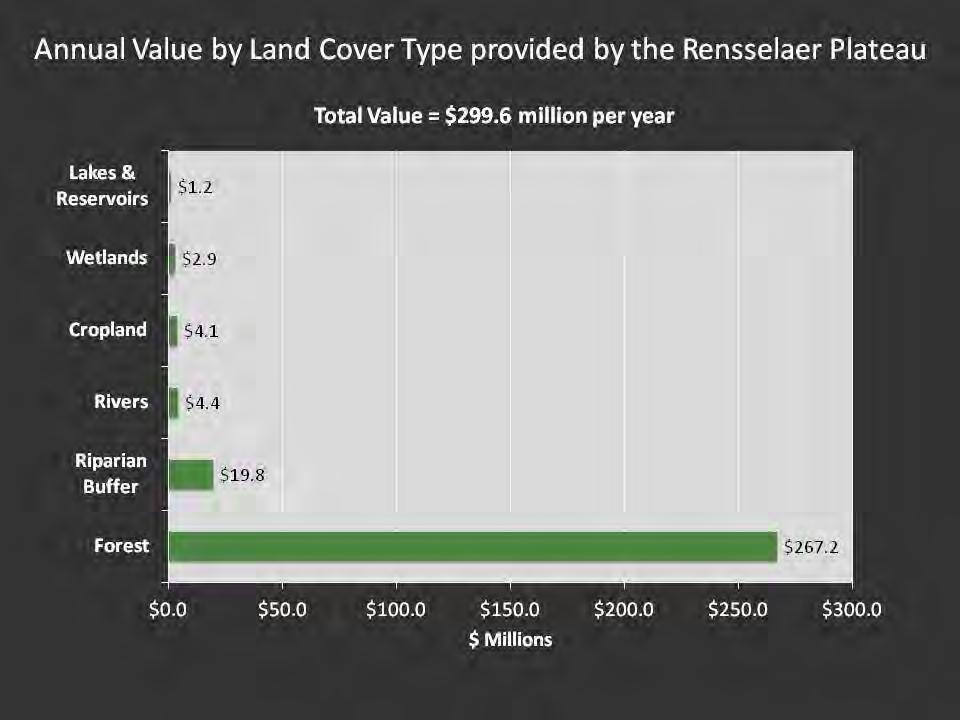
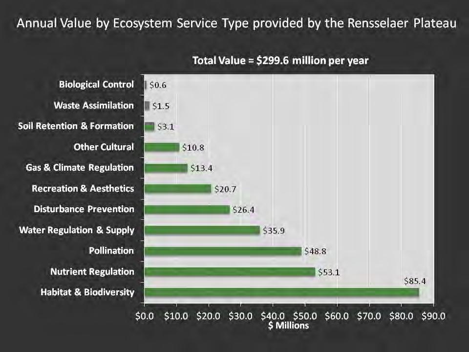
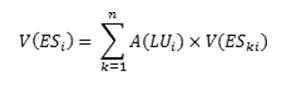
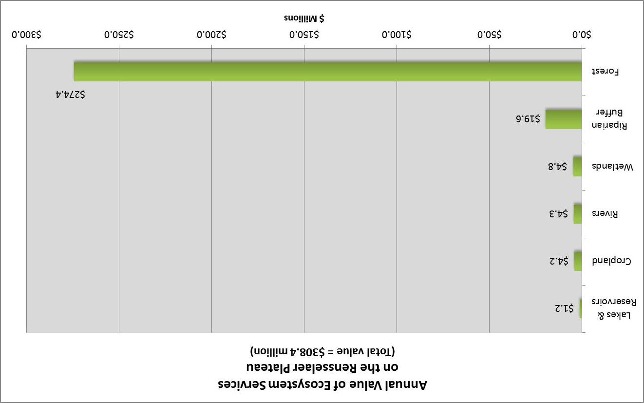
The purpose of this report is to estimate the economic values of non-market ecosystem services provided by the Rensselaer Plateau. For this study, the Rensselaer Plateau was divided into six land cover types: cropland, forest, lakes and reservoirs, riparian buffer, rivers and streams, and wetlands. Each land cover type provides a unique set of ecosystem services. The ecosystem services valued include: biological control, disturbance prevention, gas and climate regulation, habitat refugium and biodiversity, nutrient regulation, cultural, pollination, recreation and aesthetics, soil retention and formation, waste assimilation, and water regulation and supply. Spatial value transfer methodology was used to estimate the economic values of these ecosystem services on the Rensselaer Plateau. This method estimates these values by transferring available information from other studies already completed in similar climatic areas.
The values estimated in this report are intended to provide an idea of
the general magnitude of the economic value of the ecosystem services on the Plateau, and do not represent precise estimates. The numbers are generated using standard economic techniques, and are directly in line with other studies conducted in similar areas. The results indicated that by regulating and supplying water, by reducing the severity of disturbances, such as floods, and by providing pollination and waste treatment services, as well as other benefits, the ecosystems on the Rensselaer Plateau provide over $300 million in benefits each year. Of all the land cover types, the forest provides the majority of this value at around $274 million, as the forest covers a large proportion of the area of the Plateau. However, the per acre value is highest for wetlands, as this land cover type provides us with disturbance prevention services valued at around $3,600 per acre, as well as nutrient regulation services valued at around $2,000 per acre, and water regulation and supply services valued at around $1,100 per acre. Of all the ecosystem services, habitat refugium and biodiversity services offer the highest total value at around $78 million per year, followed by nutrient regulation at around $53 million per year, and pollination at around $49 million per year.
Because these are non-market benefits, the benefits are primarily calculated in terms of what it would cost the community for those services if those ecosystems didn’t exist or their healthy function which provided those services was severely depleted. For example, when flood protection provided by ecosystems is lost, this service must be replaced by levees and damaged houses restored after flood events. When local climate, pollination and drinking water benefits are lost, the economy suffers directly as well as indirectly through increased taxes and construction costs to replace the services originally provided by those ecosystems with water treatment plants, alternative recreation facilities, or private husbandry of pollinating insects. The economic values of ecosystem services estimated in this report can help to increase awareness of the value of some of the ecosystem services on the Rensselaer Plateau that we don’t often think about. This valuation is an initial step in the process of developing policies, plans and indicators which will guide future development choices.
Community Values
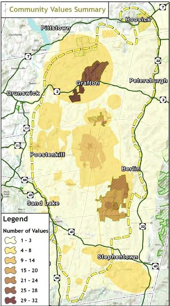
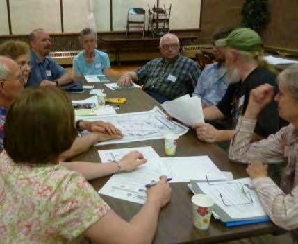
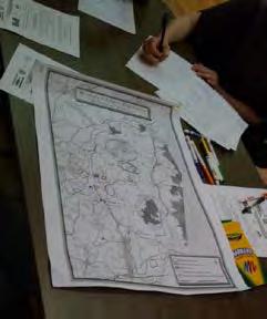
A final piece of data for the Regional Conservation Plan was derived from two Community Values Workshops that were held in May 2011 at the start of this planning process. The purpose of these public meetings – identical meetings held in Petersburgh and Poestenkill - was to gather input from the community about what they love about the Plateau.
Led by Karen Strong of Cornell University and the NYS Department of Environmental Conservation’s Hudson River Estuary Program, participants answered the questions, "What do you love about the Rensselaer Plateau?” and “Which places are important to you?" by identifying places on maps and having small-group conversations about natural resource-related activities and values. This data is, by its nature, much more spatially coarse than the ecological data as values can have a relatively general association with a particular area, and some were associated with the Plateau as a whole.
The 60 workshop participants shared with us 200 things they loved the plateau, which were classified into 11 types of values for analysis.
The values mentioned most often were recreation, biological diversity, and aesthetic values. Participants drew their most loved places on maps, and by mapping the values on a computer (in a GIS), we found that people tend to value most the areas that they know and can acce ss. Existing public lands such as Grafton Lakes State Park, Dyken Pond Environmental Education Center, Cherry Plains State Park and the Capital District Wildlife Management Area - showed up very clearly as highly valued areas. The mapped community values can be used for many purposes; for example, highlighting areas in local or regional plans or prioritizing areas for conservation action.
The values important to people identified at these workshops are supported by results from earlier community meetings in 2010, where 135 people talked about their love and vision for the Rensselaer Plateau. In that session, more than 300 values were shared with the Rensselaer Plateau Alliance. The top three types of values were nearly identical: Recreation (29%), Biological Diversity (18%),and Aesthetic (17%). These results were not mapped. The full list of piorities identified is included in the table below.
Table 3. Community Values of the Rensselaer Plateau
Values mentioned by participants
Hunting, fishing, snowshoeing, boating, hiking, hunting, skiing, State Parks,
Saw mills, maple syrup, mining, potential wind- and hydro- power, tourism,
Bear corridor, moose, fisher, wood turtle, wetlands, connectivity for wildlife,
Scenic views, natural beauty, village “feel”, dark skies
Landowner rights, freedom from restriction, gathering berries, plants, old skill sets
structures, stone walls,
landscape, love for the outdoors
kids to nature, Dyken Pond Center
Clean well water, bogs – carbon sinks,
Knotweed, pollution
Preserving natural resource values for future; legacy to next generation
Peace Pagoda
III. THE FUTURE OF THE PLATEAU
Understanding the past and present conditions of the Rensselaer Plateau allows us to think clearly about the Plateau’s future. The Plateau has changed considerably over the past two hundred years –from its mostly pristine state as Mohican hunting grounds, to a landscape that was dramatically altered to support a growing nation and fuel the industrial revolution, to its current reforested condition. The resiliency of the Plateau is inspiring. Today, the Rensselaer Plateau is home to about 8,000 people. Its forests and riparian corridors support a great variety of plant and animal life. The abundant ecological resources of the Plateau generally thrive and coexist with our human endeavors.
We have learned that the economic benefits of ecosystem services provided by the Rensselaer Plateau provide tremendous value - almost $300 million per year – to our region. At the same time, industries such as forest products, food services and drinking establishments, and tourism and recreation generate millions of dollars in local economic impact and provide jobs for area residents. These industries can generally work in harmony and with help maintain the ecological diversity of the Plateau.
Population growth, and the new homes and infrastructure (roads, etc.) that come with it, have certainly impacted the Plateau; but overall this growth has been slow relative to the greater region. The Capital Region of New York has not witnessed the kind of boom and bust cycles of development that many other parts of the country have faced. Still, even relatively slow residential growth can alter the landscape in unintended ways. Poorly executed development, especially in proximity to sensitive resources, can do much damage. Increasingly fragmented landscapes place stress on ecosystems, inhibiting their healthy function, and make traditional industries such as forestry more difficult to sustain. Ensuring that the delicate balance that currently exists on the Plateau is maintained in the future is the essential challenge that we face.
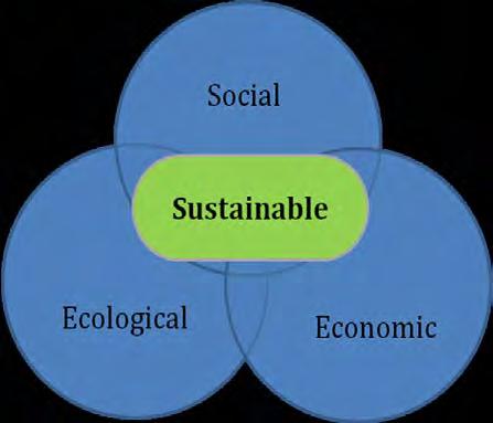
This Regional Conservation Plan recognizes that “conservation” must include efforts to protect important resources and the unique landscape of the Plateau as well as the way of life – economic activities, stewardship of private land, respect for property rights, and enthusiasm for the outdoorsthat residents of the Plateau have enjoyed for generations. To create a sustainable future for the Rensselaer Plateau, one that meets the needs of the present without compromising the ability of future generations to meet their own needs, the plan seeks to balance three interrelated components – ecological, economic and social.
In terms of the ecology of the Plateau, the plan identifies high value areas for conservation and recommends a variety of tools and techniques for conserving land on the Plateau over time. Data from the ecological assessment can be used to prioritize locations on the Plateau for conservation.
The plan also recognizes the importance of the local economy of the Plateau. It focuses on strengthening resource-based industries, in particular those that are managed in harmony with the environment, as well as the potential for expanded tourism and recreation related activities and services. Small business development, which can have a lighter ecological footprint than heavier industries, is at the core of these efforts.
The social component of the plan is concerned with raising awareness and identification with the Rensselaer Plateau. This applies to those who live and/or work on the Plateau (self-identification) as well as to those from the region or beyond who may choose to visit. Recognizing the Plateau as a unique and special place can benefit community character and quality of life while enhancing both the ecological and economic values that we seek to maintain.
As the image at right illustrates, the places where these three components overlap are where sustainable solutions for the future of the Rensselaer Plateau can be found. Initiatives that achieve balance between these three components are the most likely to succeed in the longterm; creating value for current and future generations. Actions that are directed exclusively toward one or another of these components might succeed in the short-term; but are less likely to be sustainable in the long-term. In pursuing all of the various recommendations described in this plan, it will be important to strike the proper balance between ecological, economic, and social objectives.
Conservation Plan Goals
To achieve this balance, the Conservation Plan establishes the following goals:
• Conserve the Rensselaer Plateau’s important ecological resources - In keeping with the core mission of the Rensselaer Plateau Alliance, conservation of the Plateau’s important ecological resources – generally contained within its undeveloped and un- fragmented forests and riparian areas - is one of the primary goals of the plan.
Through the research conducted as part of this effort, there now exists a much a better understanding of exactly where these resources are located. In addition, the highest value (or priority) ecological areas for conservation have been identified. The Significant Natural Areas of the Rensselaer Plateau map illustrates these ecological priorities. In some cases, lands identified as being of highest biodiversity value on the map are already protected; however in most cases they are not. Identification on this map does not restrict in anyway the use of land that is privately owned. It is hoped, instead, that awareness about the existence of these high value ecological resources will inform landowner decisions about their property and that it will be considered by municipal review boards when reviewing proposed projects under
their jurisdiction. The Rensselaer Plateau Alliance and other land conservation organizations and agencies in the region will also use this information to guide their work and to secure additional funding where possible; engaging with willing landowners to conserve these high biodiversity value lands.
Un-fragmented forests represent the best opportunity to protect plant and wildlife habitats, water and drinking water resources in the Rensselaer Plateau region. Large, un- fragmented forest blocks are critical to the existence of wide-ranging and forest interior species and they contain a diversity of habitats that are of great value to wildlife because they provide a wide variety of conditions for the greatest number of species. Wetland and forest functions increase when connected; providing important resources for forest-dependent species as well as supporting a host of wetlands-dependent species. Although it may be easier to protect a single point of significance associated with a particular species under threat, it may be more important and efficient to focus on land conservation efforts at a broader scale on the Rensselaer Plateau. Un-fragmented forest ecosystems that include undisturbed matrix forests and a diversity of different habitats within close proximity to one another are critical to regional efforts to protect the Plateau’s more uncommon species and to keep common species common.
It is probably not possible to protect all areas of the Plateau that are worthy of conservation; however, conserving as much of it as possible and ensuring that the remainder is used or managed in an environmentally responsible manner is an overarching goal of this plan. The Significant Natural Areas of the Rensselaer Plateau Map shows us the most important environmental resources on the Plateau and serves as a useful guide for prioritizing areas to conserve. Instead of attempting to identify specific parcels to conserve at this time, the vastness of the Plateau and the relatively undisturbed nature of much of this landscape calls for a flexible approach based on information and opportunity. But at the regional scale, conservation efforts must be a balancing act among many factors; including the quality and scarcity of habitats, ease of protection, the presence of other protected lands, immediate threats and other human factors as well. Sometimes opportunity – in the form of interested landowners or available sources of conservation funds – can influence priorities. With the information about the Plateau’s resources that is now available and the variety of conservation tools and techniques at our disposal (described in the following section), the user of the plan and other partners around the region will work with local landowners, municipalities, and businesses to conserve significant portions of this landscape in the coming years.
• Support the expansion of local economic activity that is compatible with the environmental health of the Rensselaer Plateau - As discussed earlier, there are several key industries on the Plateau that contribute to the regional economy, provide local jobs, and increase the vitality of communities on and near the Plateau. Forestry, tourism, recreation, and eating and
drinking establishments are all important, with forestry having the greatest economic impact and food services and drinking places providing the most jobs on an annual basis. The economic analysis also suggests that there may be opportunities to expand the impact of tourism and recreation because there are few existing amenities that support tourism and recreation on or near the Plateau. All of these economic activities, when well managed or operated, are generally compatible with the conservation goals supported in this plan. In fact, to the degree that these activities are done responsibly and provide income and economic security to local residents, they in turn help nurture conservation of the Plateau’s resources. Economic stress or scarcity makes conservation and stewardship efforts - by individual landowners, by municipalities and other government agencies, and by organizations – much more difficult to sustain.
The forest products industry has a long history on the Rensselaer Plateau. Though large portions of it were clear-cut over a century ago, the forest has grown back and now covers about 90% of the Plateau. While today’s best practices in forest management help to sustain the forest as both a natural and an economic resource, often woodlots are not managed using these guidelines. Large companies manage significant tracts of land on the Plateau and smaller, local operations work with landowners to harvest timber on individual parcels. The health of the forest is enhanced and the local economy is strengthened by this industry. For the most part, these businesses view themselves as stewards of the land and are interested in understanding how to minimize their impacts on sensitive ecological resources. Sustainability is defined as maintaining productive capacity of the resource. Silviculture research shows that the productive capacity of Plateau forests to grow valuable high quality hardwood timber can be achieved using best practices forest management plans. Private landowners are encouraged to use consulting foresters and develop long -term management plans that help them meet the standards of the Forest Stewardship Council ( FSC), Sustainable Forestry Initiative (SFI), or Tree Farm certification.
Ecological information developed as part of this plan will be shared with the local forest products industry, and continued efforts to strengthen partnerships with the forest products industry should benefit both the conservation and economic goals of this plan.
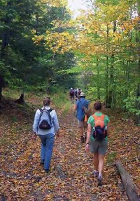
Visitors to the Rensselaer Plateau are another potential source of increased economic activity. Currently they tend to take advantage of recreational opportunities that exist on public lands such as Grafton Lakes State Park. Creating more
opportunities for enjoyment of the outdoors and encouraging the growth of local businesses that cater to these visitors would create jobs and have a positive economic impact on the communities of the Rensselaer Plateau. Increased recreational use of the Plateau might also create a stronger constituency for conservation as more people in the region become aware of the myriad resources found across this landscape. However, more visitors to the Plateau would also have the potential to negatively impact these resources or to alter the quality of life found here. Though we are far from that potential concern now, we should be mindful to maintain a careful balance in the future.
• Raise awareness about the Rensselaer Plateau throughout the region – An important goal of this plan is to encourage people who live on or near the Plateau, elsewhere in the Capital Region, and beyond to recognize the Rensselaer Plateau as a distinct and special place. Identification with the Plateau – or self-identification in the case of people who live here – can increase the sense of pride and responsibility for stewardship of the resources that are found here. Because the Plateau extends across portions of ten towns and one village, it is especially challenging for this geographic feature to standout in our imaginations as a separate and unique place. However, great strides have already been made in this regard in recent years.
To expand recognition of the Rensselaer Plateau, several things could be done:
o Creation of a Rensselaer Plateau logo that could be used to unify various activities and marketing efforts, including the ones described below.
o Placement of “Welcome to the Rensselaer Plateau” signs –with the logo - at all major roadway entrances to the Plateau.
o Establishment of a “buy local” program for wood products and other items made or harvested on the Rensselaer Plateau.
o Designation of a Rensselaer Plateau Scenic Byway (a touring route for drivers) on or around the Plateau.
The logo for the Hudson River Estuary uses an image of an Atlantic Sturgeon – these signs are placed along major roadways wherever they cross tributaries of the estuary.
o Development of a network of hiking, bicycle touring, mountain biking, equestrian, and snowmobile trails across the Plateau.
Expanding the opportunities for outdoor recreation, making more people aware of these opportunities, and creating a unifying “brand” that ties these opportunities together in a way that raises awareness about the Rensselaer Plateau will strengthen the local economy and enhance conservation efforts.
The Shawangunk Mountains Scenic Byway - http://mtnscenicbyway.org – ties together the communities in this portion of the Hudson Valley. It serves to raise awareness about the resources found in the region and to generate economic activity in the form of increased tourism. This could serve as a model for the Rensselaer Plateau.
IV. A GUIDE FOR DECISION-MAKING
This Rensselaer Plateau Regional Conservation Plan should be viewed as a guide for decision- making. It is intended that different “users” of the plan – landowners, municipalities, and interested organizations or agencies (local/regional/statewide) – will utilize information in this plan to inform their decisions. It is important to note that the plan does not compel any of these users to take specific actions. The Rensselaer Plateau Alliance is not interested in using this plan to tell towns or landowners what to do, or assuming any authority that it does not have. Instead it sees engaged towns and informed landowners as key to conserving the resources of the Rensselaer Plateau.
Recommendations for achieving a sustainable future for the Rensselaer Plateau are introduced below in the form of tools and techniques to be considered by the different users of the Regional Conservation Plan. This approach acknowledges that decisions effecting the future of the Plateau will be made individually or collectively by many independent land stewards over time. Providing information and encouraging consideration of these tools and techniques by a diverse audience is consistent with the mission of the Rensselaer Plateau Alliance and should ensure widespread participation in the implementation of the plan over the coming years.
Tools and Techniques for Landowners
Private landowners are the primary stewards of the land on the Rensselaer Plateau; and overwhelmingly these individual landowners do a great job taking care of the Plateau’s abundant natural resources. Private landowners will continue to have a critical role to play in shaping the future of the Rensselaer Plateau. Fortunately there are a wide range of tools and techniques available to assist individual landowners in achieving the specific goals that they have for their land in a manner that is consistent with the long-term health of the Plateau. Many of these are described below.
• Information for Continued Stewardship – For most private landowners, the simple goal is to be good stewards of the land that they love. Stewardship requires information. To be good stewards of their land, landowners can always benefit from more information about the resources that are found there and best practices for managing these resources. The Ecological Report prepared as part of the development of this plan provides detailed information about the flora and fauna found across the Plateau. This information will be made available to anyone who is interested in learning more about the ecological resources found on their land. Management guidance for each ecological community type can be found at www.guides.nynhp.org. In addition, the RPA recommends landowners use consulting ecologists and foresters to help manage their properties. Depending on available funding, RPA will seek to bring some of these services to landowners as part of implementing the Plan’s objectives.
• Succession Planning – What happens to one’s property after death is a critically important yet often overlooked question. Landowners can ensure that their property is passed along to their heirs (with a minimum of estate taxes) and managed in accordance with their values by engaging in succession planning in advance of old age or illness. There are numerous resources available that provide information about this important topic. Links to several estate planning guides are provided on the RPA’s website, and there are many professionals in the region who can assist individual landowner’s with their succession planning needs. The Rensselaer Plateau Alliance will continue to make information available via its website and through community meetings focused on this subject.
• Conservation Easements – Some landowners are interested in formally setting aside all or part of their property for conservation purposes. The most commonly used and effective tool for doing so is the conservation easement. A conservation easement allows the landowner to continue owning and using their property (for specified conservation purposes), while restricting the future development of the property. Such easements can be effective for a set period of time (a term easement) or, more commonly, are effective in perpetuity (permanent). The easement is prepared as a legal document (like a deed) and filed at the County Clerk’s Office.
Conservation easement: A conservation easement, or grant of development rights, is a legal agreement on a parcel of land that governs what can occur on the land in the future. A conservation easement can be tailored to the specific needs of a parcel. Typically a conservation easement will protect working lands for forestry and/or agriculture, and can either prohibit or limit future development, and can guarantee future public recreational access. It is granted by the landowner to a "holder" which is usually a land trust or public agency. The landowner remains owner of the property and continues to use it and pay taxes, while the holder is responsible for ensuring that the terms of the conservation easement are followed by monitoring it on a regular basis.
There are many reasons why a landowner might choose to place their land under a conservation easement. A simple desire to see the land remain undeveloped for future generations is one; but there are often financial considerations that contribute to the decision. For property tax purposes, land under easement c ould be assessed at its conservation value because it has no development potential. If the landowner donates the easement to a land trust - such as the Rensselaer Land Trust or the Agricultural Stewardship Association - the value of this donation could be deducted as a charitable contribution for income tax purposes. In some cases, there may be money available from an organization or government agency to pay the landowner for all or part of the value of the conservation easement. In such cases, the purchase of the conservation easement is known as a Purchase of Development Rights (PDR). (Note: all of these financial considerations should be reviewed with an attorney or other qualified tax
professional prior to making any decision about whether or not to donate, lease, or sell a conservation easement).
When you, as a landowner, sell development rights as part of a PDR program, you are paid a negotiated price for the development value of the land. All other rights remain with the landowner, including the underlying fee title to the land. The value of the development rights is the portion of the total land value attributed to its development value. An appraisal is required to determine and apportion the value of development and other rights (e.g. recreation, timber, etc). Each easement is unique and terms are negotiated. In general, development rights are sold by the landowner who remains the fee owner of the land. One of the attractions of a conservation easement is that you continue to own the right to enjoy your land and its open space uses such as recreation, wildlife management, forestry and related economic activities.
Whatever their reasons, it is important to recognize that conservation easements are voluntary and must come from willing landowners. They may not be the right tool for everyone, and a landowner should never be made to feel compelled to offer one.
The Rensselaer Plateau Alliance understands that its role is to make information about conservation easements available to landowners and to encourage and facilitate the process of executing them when there is landowner interest. For example, the US Forest Service’s designation of the Rensselaer Plateau as a Forest Legacy Area in December 2010 has made available a new source of funding for landowners who are interested in selling development rights on their property. The Rensselaer Plateau Alliance, along with its conservation partners in the region, is participating in this program by reaching out to landowners on the Plateau to provide information about this opportunity. It is also working directly with interested landowners, the Agricultural Stewardship Association, the Rensselaer Land Trust, and the NYSDEC to package potential PDR projects into a grant application to the US Forest Service. The first grant application for the Rensselaer Plateau Forest Legacy Area was submitted in the Fall of 2012. Approximately 2,500 acres of land, owned by 14 different landowners on the Plateau, were included in this first grant application.
• Sustainable Forest Management Practices –
Many landowners on the Rensselaer Plateau are interested in managing their forestland for timber. Through the education component of its Working Forests Initiative, the Rensselaer Plateau Alliance encourages and supports sustainable forest management practices by providing information to interested landowners. The RPA website includes links to numerous resources available to assist forest owners. The RPA, together with partners such as the New York Forest Owners Association (NYFOA), the Hudson River Estuary Program,
Cornell University, Cooperative Extension, and others, also hosts informational workshops and woods walks throughout the year that are intended to educate woodlot owners about such practices. Other programs, such as the NY Master Forest Owner Program, make available trained experts who can be invited to walk a landowner’s property for consultation about forest management practices and other topics of interest to forest owners (such as the NYS 480-a Forest Tax Law Program, etc.). The Sustainable Forestry Initiative (SFI) and the American Tree Farm System are examples of national level programs available to landowner s that provide information and certification programs for sustainable forest management. Often lanowners have the misconception that selective cutting is sustainable forest management, unfortunately it usually isn’t. For more information on best forest practices, consult the Forest Stewardship Guide at http://pubs.cas.psu.edu/FreePubs/pdfs/uh082.pdf
• Low-Impact Development – Some landowners on the Plateau may desire to develop some portion of their land for residential or other purposes. Depending on their individual circumstances, the development envisioned might be small (an additional house lot for a family member) or somewhat larger (a residential subdivision with lots for sale). A general lack of roads and infrastructure, as well as its challenging topography and poor drainage do limit development pressure on the Plateau. Zoning laws and/or other local land use regulations also place some additional limitations on the type and intensity of development in most of the Plateau’s municipalities. However, these regulations tend to be very broad in nature. They do not provide guidance about how development can be accomplished in harmony with the specific parcel of land to be developed.
Low-impact development (LID) is a term that describes a simple process that can be used to guide the design of a proposed development in a manner that is more sensitive to the environment and the unique characteristics of the site. According to the State of Massachusetts Smart Growth / Smart Energy Toolkit, “LID begins with effective site planning which focuses on mapping of environmental resources to be conserved; identification of building areas which best accommodate development economically and ecologically; and the use of design techniques to reduce impervious covering and the impacts to water quantity and quality, such as clustering, permeable surfaces, reduced roadway pavement widths, and the preservation of natural drainage pathways.” Though much of the focus of LID design techniques described in the literature are related to stormwater management, the principle of assessing the resources present on a site and using this assessment to guide site design is fundamental to all good design practice. This approach should be used by anyone who wishes to develop their land in a sustainable way, and it can be applied to development of any size.
The Rensselaer Plateau, with its abundance of natural resources, is an ideal location for encouraging the use of low-impact development techniques. The Ecological Report that has been prepared as part of the development of this plan could serve as an important source of information at the earliest stages of the design process.
• Public Access for Trails and Other Recreational Purposes – Some landowners on the Plateau are willing to consider allowing members of the public to have access to their land for hiking, mountain biking, cross-country skiing, snowshoeing, or other recreational purposes. In fact,
many landowners do make private arrangements with particular individuals to hunt on their land. However, concerns about liability or inappropriate behavior by some users can dampen a property owners enthusiasm for allowing the kind of general public use that a trail system would require.
One notable exception is for snowmobiling. Thanks to a state program administered by the NYS Office of Parks, Recreation, and Historic Preservation (OPRHP), snowmobile clubs around Upstate New York receive annual funding set aside from snowmobile registrations. This funding allows the clubs to work with private landowners to address their concerns about liability and other issues, to negotiate easements and create local networks of snowmobile trails, and to sign and maintain these trails each winter. As a result of this state program, a main corridor trail runs north to south along the Rennselaer Plateau and several secondary trails link this corridor trail to destinations such as Grafton Lakes State Park. This highly successful state program benefits winter tourism throughout the state and could be a great model for other types of trail systems.
Landowner concerns about allowing public access to their property for recreational purposes are important; but in almost all cases the issues raised are solvable. For example, one of the most common landowner concerns is the risk of liability. Under NYS General Obligations Law landowners and trail operators are generally relieved of liability when allowing public use of their land for recreational activities such as hiking or bicycle riding. Still, the prospect of legal action and the potential cost and hassle associated with defending oneself against such claims (even if they are unlikely to succeed) can be a deterent to landowner willingness to participate in efforts to establish trails on their property. There are, however, insurance programs (through muncipalities or umbrella policies held by organizations that sponsor such trails) that can substantially limit these risks.
Fortunately there are some good resources available in our region to help address this, and other related landowner concerns about trails. Two existing publications prepared jointly by the Hudson River Valley Greenway and Parks and Trails New York provide a good base of information from which to start. The first is called Getting Started: A Guide to Planning Trails in New York State. The second, geared toward landowners, is called Getting Involved: A Community Trail Handbook for Landowners.
The Rensselaer Plateau Alliance - along with partners such as the Hudson River Valley Greenway and member organizations such as the Mohawk-Hudson Cycling Club, the Black River Raider Snowmobile Club, the Grafton Trail Riders, the Taconic Hiking Club, the Capital Region Nordic Alliance, and the Saratoga Mountain Bike Association – will continue to work with landowners on the Plateau to advance trail systems and other recreational opportunities for all seasons.
Tools and Techniques for Municipalities
Local governments on the Rensselaer Plateau can do much to encourage, and in appropriate circumstances require, that the Plateau’s ecological resources are protected. The ten towns and one village can also do more to promote sustainable economic growth and to raise awareness and identification of the Rensselaer Plateau at the local and regional level. Some of the tools and techniques available to municipalities are described below.
• Cooperation with neighboring communities – Recognizing that resources like streams and wildlife do not follow municipal boundaries, it can be helpful for towns to expand their working relationships with each other. For example, in the Shawangunk Mountain area near New Paltz, 11 towns and 2 villages have signed an intermunicipal agreement to work together to help promote and preserve the quality of the region. The communities have organized around the mountains and, interestingly, along the scenic highway routes by forming a state and federallyrecognized “scenic byway”.
Up here on the Rensselaer Plateau, some of the opportunities for expanded intermunicipal and other partnerships include:
o Create a set of shared land use and sustainable development management tools such as rural conservation development design guidelines -building upon the natural resources mapping/ecological assessment and other information assets developed in this plan.
o Undertake cooperative planning and economic development projects with neighboring communities - for example, creating a tourism development strategy that enhances the connections between the tourism-related businesses and the natural and recreational landscape in more than one community.
o Expand cooperative arrangements with the RPA and its partners - in particular the land trusts in the region to help them help land owners protect the land for future generations.
o Help identify and advocate at the state and federal level for programs and needed legislation that will help us to conserve and promote our area’s resources - through the NYS Open Space Plan, the NYS Statewide Comprehensive Outdoor Recreation Plan (SCORP), the NYSDEC Hudson River Estuary Program, the Hudson River Valley Greenway, federal farm and forest land conservation programs, and other kindred programs. This is a special region, with resources on a scale that is beyond the present funding capacity of our local governments and land trusts to adequately preserve.
This planning effort has already set the stage for greater cooperation between the muncipalities of the Rensselaer Plateau. For example, the Superv isors from each community (and the one mayor) were invited to participate together in a casual dinner and conversation about the Plateau as part of the stakeholder outreach process that led to this plan. Though not all of the Plateau communities were represented, most were. It was the first time that these
elected officials have had the opportunity to get together to share ideas and talk specifically about the Plateau. Recognizing that such dialogue is the foundation for stronger working relationships in the future, the Rensselaer Plateau Alliance intends to convene such meetings on a periodic basis.
• Distinguish the Rensselaer Plateau in local plans – Each municipality now has available to it detailed information from the Ecological Report prepared for this regional conservation plan. This information enhances local identity and provides perspective about some of the unique aspects of the local ecology. As each community reviews and updates its own comprehensive plan in the future, the Rensselaer Plateau can be readily recognized and considered as an important part of the community’s natural and cultural resource base.
Further, as a community considers preparation of a special plan - such as an open space or recreation plan, economic development strategy, etc. - the ideas, opportunities and resources identified in this regional conservation plan can be a helpful foundation for that more locallyspecific planning activity.
• Local Land Use Tools – Addressing the Problem of Fragmentation – Fragmentation is the process by which a large area of habitat, such as a forest, wetland or meadow, is broken up into smaller pieces. Modern settlement patterns are the largest contributor s to habitat fragmentation in our country today roads, utility corridors, single-family homes that collectively are spread out across the landscape fragment habitats with their building footprints, lawns, roads and driveways.
Habitat fragmentation on the Plateau can create dramatic effects on wildlife for several reasons. The process of habitat fragmentation inherently results in loss of habitat as land is cleared for roads, homes and other development. This loss of habitat is coupled with the breaking up of one large habitat “patch” into two or more separate pieces. The isolation of one habitat patch from another creates barriers for dispersal of seed or for wildlife travel.
Fragmentation does not just affect wildlife. Many working forests and farms require large patches of harvestable land, often with good soils for plant growth to remain viable. However, some of the most accessible forest and farm lands
An example of fragmentation, where a large area of intact forested wetland habitat is divided by roads, homes and other types of development.
are often just as suitable for growing houses as they are for growing trees and crops. Thus, in many cases, the choice comes down to economics: will the land return more value if it developed for homes or if it is used for forestry? In most cases, such as on the Rensselae r Plateau, the economics of development even if only into large acreage homesites will far outcompete the fiscal return of a large woodland holding.
One of the major goals of any successful conservation program is to drastically reduce the rate of fragmentation of both wildlife habitat and timberland. One important way to reduce fragmentation is to ensure that local land use tools do not promote settlement patterns that lead to excessive fragmentation. Updating land use tools is no easy task. Most local land use and zoning regulations favor the types of development patterns that contribute to fragmentation. This plan is focused on expanding partnerships and providing tools to conserve green infrastructure. These tools are primarily programmatic (such as identifying grant programs for conservation and GIS mapping assistance), information-based (such as the ecological communities datasets), and policy-based. Yet, it recognizes that without making changes to local land use tools, the vision of a maintaining an intact system of “green infrastructure” resources will, in the long run, prove difficult to obtain.
Community plans and zoning laws can be tremendously important tools for conserving and appropriately guiding how the resources on the Plateau are developed. Zoning codes, unfortunately, are often drafted with inadequate consideration of the long-term or largeproject implications.
Down in the lower Hudson Valley, for example, a large resort-type development on several thousand acres which could have been an economic boon to the area, was poorly guided by the local plan and zoning which had not appropriately anticipated that kind of project. And so, instead of guiding what would work and what would be acceptable to the community, the town plans and zoning and subdivision laws fell far short. The local regulations provided for a level of development that was far too great and the regulations failed to provide any guidance about how to appropriately develop in a sensitive, mountainous landscape. Hence, development plans were prepared that met, in fact, exceeded the letter of the law, but essentially were dead on arrival in terms of meeting a reasonable respect for the lay of the land. Instead of appropriately guiding what could have been a wonderful project, the lack of good plans and regulations led ultimately to frustration and litigation. From a community perspective, the investment in better planning and zoning would have been far less expensive than the costs of legal defense; and the community would have had significant economic and fiscal benefits for decades new jobs, larger tax base. Instead, no jobs and stagnant tax base. In this case, penny not spent is a dollar not earned.
Some of the innovative zoning tools and techniques that local communities should consider utilizing to better guide development on the Rensselaer Plateau are described below. Not all of these approaches will be appropriate for every community. Instead, local leaders should select those that make the most sense for their community based on the goals and recommendations identified in their comprehensive plans.
Encourage Conservation
Subdivision Design – Like lowimpact development (discussed under landowner tools above), conservation subdivision design is a concept that simply makes sensedesign with nature. Local towns can create and adopt subdivision regulations and design guidelines to help shape growth and change with the Plateau in mind. The series of images at right come from a set of conservation subdivision guidelines adopted by a town in New York State.
The foundation of conservation design is that it begins with a detailed analysis of the site to be developed and it uses this analysis as the basis for design. On the Plateau, planning boards and conservation advisory councils can use science based data (like the ecological communities data developed in this plan) to define the conservation areas and configure them to connect habitat across property boundaries.
In conservation subdivisions, creativity and flexibility replace rigid lot size and other dimensional requirements (without altering the overall density). The development approach illustrated in these images reduces the cost of infrastructure (such as roads to service the new subdivision), and the net property value of the project is greater than that of a conventional project as each owner’s property is enhanced by the setting of the protected
Conservation subdivisions are a “no cost” solution for the town to maintain some green infrastructure resources. In this example the resources on the property are shown in the top image, followed by a “conventional” development plan. The bottom image shows a conservation based design that maintains the overall project density while preserving agricultural land, hedgerows, wetlands and treelines. The conservation design also provides new trails that could be for the local residents or the greater community.
farm landscape along the road - a farm that would have been chopped up under typical development.
Allow a wide-range of traditional rural activities (land uses) in zoning – Encouraging a variety of conservation-friendly land uses in zoning and in economic development plans is a perfect strategy for the Plateau. Traditional enterprises related to agriculture and forestry can be great neighbors. For example, an analysis of the Skaneateles Lake Watershed (the water supply for Syracuse) showed that water quality of feeder streams to the lake were of excellent water quality and that the nutrient management and sound stormwater management practices being used by farmers in the watershed offered proof that these uses were perfectly compatible with the drinking water supply functions of the lake. There are many economic activities that can create wealth and support employment that are highly compatible with the environmental health and quaility of life of the Rensselaer Plateau. Unfortunately, many local zoning laws limit the land use options available to landowners. Single use districts (such as typical residential zoning districts) can make traditional uses of the land difficult to accomplish. This can hamper small scale economic activity that would otherwise benefit landowners and the local economy while reducing development pressure. Local zoning rules should be carefully reviewed to ensure that a wide range of rural uses are in fact permitted.
Forest Zoning – Forest Zoning is another zoning approach that towns could consider, particularly for large tracts of working forest on the Plateau. Establishment of a Forest Zone for such areas would help ensure that forest land is managed for forest uses such as timber harvesting while discouraging uses such as residential subdivisions that could conflict with forest uses. This type of zoning with appropriate assessment re-evaluation of land as only for forest would also help limit fragmentation of the forest and conversion of forestland to developed uses. In a Forest Zone, an average density standard of one dwelling unit per 10 or 20 acres helps to maintain a healthy base of forestland in the community. Other uses that complement and support the forestry industry, such as sawmills, should also be permitted in these zones.
Overlay zoning – Overlay zoning is another zoning technique that a municipality on the Rensselaer Plateau could employ to protect specific types of resources consistent with the goals laid out in its comprehensive plan. Because natural or cultural resources do not necessarily follow zoning boundaries derived for other reasons, and because these resources often cross such boundaries and overlap more than one zoning district, the concept of an overlay zone can be very useful. Information about the Plateau’s ecological resources created as part of this Regional Conservation Plan and made available to all of the municipalities on the Plateau could be used to guide the establishment of such zoning by the local Town (or Village) Board.
For example, stream corridors typically traverse a community, flowing through a variety of areas and often more than one zoning district (a residential district, a commercial district, etc.). From an environmental standpoint, however, there may be some basic development requirements that a municipality might wish to employ to protect water quality in some or all of its streams. Limiting disturbances and the clearing of natural vegetation within a specified
distance from the stream to prevent erosion and sedimentation is a fairly common approach. In such cases, an overlay zone could be established in the local zoning law; the zone boundaries would follow the stream corridors in the municipality. Within the overlay zone, special requirements designed to protect the stream corridor would be provided. These requirements would apply to any proposed project within the overlay zone in addition to, or sometimes in place of, requirements that exist in the underlying zoning district.
Incentive Zoning – Incentive zoning is another zoning technique that could be utilized by local municipalities to encourage the creation of community benefits or amenities as part of new development. Under an incentive zoning law, a municipality offers specific incentives to developers, such as increased density or expedited project review in return for specified community benefits such as open space conservation elsewhere, the provision of public trails or other recreation facilities, or other amenities desired by the community. Local municipalities on the Rensselaer Plateau could use incentive zoning in any number of creative ways. For example, it would be possible to allow increased development density in parts of a Town that are well suited for development (perhaps off the Plateau where infrastructure exists) in exchange for a contribution toward the municipality’s open space fund (perhaps used to conserve environmentally sensitive, scenic, or potential recreational land on the P lateau).
• Develop local conservation programs – It is hoped that this Regional Conservation Plan will create a solid foundation upon which to build a network of support at the local level for helping interested landowners keep their land in a “solid state of conservation.” This is not a passive activity, rather it is an investment in finding financially viable ways to bring long-term stewardship of land to property owners with the help of the entire community. There are many ways to accomplish this goal and there is no better partner in conservation for a landowner than their own town and townspeople.
A number of communities in New York State have developed local programs to finance, in whole or in part (as a match to other sources of state, federal, or private grant funding) , land conservation efforts. Typically, these programs are funded through annual budget appropriations or through borrowing (bonding), and in many cases voters in the community have had the opportunity to vote on whether to approve such use of funds. In some communities, a small percentage of the real estate transfer tax is set aside for such purposes (with the approval of the state legislature). Though this type of program might be diffic ult for the small municipalities of the Rensselaer Plateau to undertake in the current economic and fiscal climate, it should not be ruled out as a possibility in the future.
• Environmental Review (New York State Environmental Quality Review - SEQR) – The effort to put together this Regional Conservation Plan has helped to foster greater understanding of the underlying ecological resource base found on the Rensselaer Plateau. Under the New York State Environmental Quality Review Act (SEQR), this information can now be used by each local decision-making body (town board, planning board, zoning board of appeals, etc.) as it takes the required “hard look” at potential adverse environmental impacts that could be associated with “actions” under its jurisdiction. In other words, under SEQR every municipal decision (to spend money, approve projects, etc.) is already required to take potential environmental
impacts into consideration. The information developed for this Regional Conservation Plan –the ecological assessment, the economic studies – can all be used by local boards to help make this process easier and guide their decision-making.
In addition, the provisions of SEQR could be used by local municipalities in a proactive way to help achieve their environmental conservation goals. For example, communities could work to designate Critical Environmental Areas (CEA’s) using the ecological data collected for this plan as a starting point. Designation as a CEA gives an area an added level of importance for environmental review purposes under SEQR.
Muncipalities should also consider smart use of the planning aspects of the environmental review process-for example, the use of Generic Environmental Impact Statements (GEIS). Far too often, incremental changes are ignored as part of environmental review, yet over time, these incremental changes can have a significant adverse impact that goes unchecked until it is too late. Road frontage development for example can create a pattern of excessive residential strip development in what once was a rural area that “overnight” transitioned to a suburban place by simply the development of roadside house lots. By looking ahead “generically” at environmental issues, one can better address responses to change in a more organized and equitable way. The SEQR process can be used proactively to help plan and mitigate impacts creatively-it should not be used only as a last-ditch effort to stop a project.
Tools and Techniques for Organizations / Agencies
The Rensselaer Plateau Alliance, its alliance partners, and other organizations and government agencies (regional, state, and federal) that have an interest in the future of the Rensselaer Plateau all have an important role to play in advancing the Regional Conservation Plan. In fulfilling their roles, these organizations must continue to respect the property rights of private landowners and acknowledge the “home rule” principle that underlies local government in New York State. Working alongside landowners and local municipalities, the possible roles of these organizations and agencies are described below.
• Provide Information and Educational Resources - Perhaps the most important role for the Rensselaer Plateau Alliance, and the other organizations and agencies working in the region, is to continue to provide information and educational resources and opportunities. This role is core to the RPA’s mission and it is one that the organization has already embraced. The RPA website (www.rensselaerplateau.org) is a good resource for anyone interested in learning more about the Rensselaer Plateau and it provides links to more specific resources that might benefit landowners, municipalities, and others. Informational meetings, woods walks, lectures, and other events are held throughout the year and have been viewed favorably by those who have participated. The RPA has also started to work with local schools to develop programs that utilize the natural resources in their Plateau backyard and teach students about the value of the Plateau, and it intends to expand such efforts in the coming years.
• Provide Technical and Financial Assistance – Development of this Regional Conservation Plan would not have been possible without the financial contribution and technical assistance provided by the NYS Department of Environmental Conservation (DEC) Hudson River Estuary Program. Additional financial resources were provided by the Hudson River Valley Greenway and by the Open Space Institute. Small, cash-strapped local governments in the hilltowns of the Rensselaer Plateau are not in a position to fund this work in a significant way. Continued technical and financial support from these and other organizations and agencies will be critical to the success of ongoing efforts.
• Convene and Facilitate – Another important role that the Rensselaer Plateau Alliance has started to serve is that of regional convener and facilitator. During the development of this plan, the RPA suceeded in bringing together the Supervisors from a majority of the Plateau’s muncipalities for two informal dinner meetings. These were the first times that the elected leaders from these communities got together specifically to discuss the Rensselaer Plateau. Meetings with stakeholders such as local planning, zoning, and environmental officials, representatives from the forest products industry, and large landowners were also groundbreaking in this regard. The RPA intends to continue serving as a conduit for regional cooperation across the Plateau by convening and facilitating such dialogue on an ongoing basis. As it did with the recently submitted Forest Legacy grant application, the RPA will also continue to facilitate dialogue between interested landowners and the land trusts or state/federal funding programs that best fit and can help these landowners achieve their conservation goals.
• Advocate – In certain circumstances, the Rensselaer Plateau Alliance, and other organizations and agencies working on the Plateau, should advocate for legislation, funding, or other items that would help landowners or local governments achieve goals that are compatible with this Regional Conservation Plan. This may be as simple as providing a letter of support for a grant application; or it might involve something more complex. For example, during the course of developing this plan it was noted that the NYS 480-a Forest Tax Law Program is not very popular with landowners. As a result, few landowners on the Plateau participate in this program. However, it is said that neighboring states such as Vermont have similar programs that are heavily utilized by landowners in those states. If this is true, organizations such as the Rensselaer Plateau Alliance, the New York Forest Owners Association, the Empire State Forest Products Association and other organizations could advocate for change at the state level.
V. IMPLEMENTATION
This Regional Conservation Plan recognizes that decisions affecting the future of the Plateau will be made individually or collectively by many independent actors over time. An overarching authority responsible for the Rensselaer Plateau does not exist and is not desired here. Instead, implementation of the Regional Conservation Plan will be the shared responsibility of landowners, local governments, not-for-profit organizations, and government agencies that are interested in the future of this vast landscape. We will need to work together to accomplish our mutual goals.
Obviously, individual landowners are, and will continue to be the most important contributors. For generations they have been the primary stewards of this landscape, maintaining the working forests and taking good care of their land. This plan does not compel landowners to do anything, nor does it change in any way their rights and responsibilities as landowners. It is hoped that data about the Plateau’s ecological resources that has been developed as part of this plan, and the ongoing and potential new programs that are described in this document, will help landowners in their critically important stewardship role. Most of the ideas and recommendations contained in this plan are really about making information available and expanding the options that landowners have for their land.
Local municipalities must also play a key role. Though permanent land protection is an important focus, there will probably never be enough resources available to conserve all of the unprotected conservation areas identified in the plan. Thoughtful planning regarding the location, density and design of development – so that it minimizes harmful impacts while allowing for a reasonable and beneficial level of economic return - can complement regional land protection efforts. In New York State this is solely the function of local government, and it is one of the most important responsibilities that muncipalities have.
To implement this Regional Conservation Plan, local governments should:
• Review their Comprehensive Plan to see that it is up-to-date and, to the degree that their community values the resources of the Rensselaer Plateau, that it recognizes the Plateau in its analysis of exisiting conditions, its vision and goals for the future, and in its recommendations and implementation strategies.
• Ensure that their land use regulations are consistent with their Comprehensive Plan and that these regulations actually facilitate the development and conservation goals outlined in their plan. Too often, poorly conceived or outdated regulations force development outcomes that are contrary to the desires of the community as expressed in their plan. The local land use tools described in Section IV (under Tools and Techniques for Muncipalities) are examples of some of the more innovative approaches that are being used by communities in New York State to balance their development and conservation goals.
• Consider undertaking more specific area or topical planning; such as a local Open Space Plan that would examine the community’s resources and explore alternatives for their portion of the Rensselaer Plateau and other parts of the community in more detail.
• Invest in land conservation activities as appropriate, and/or seek out technical assistance and funding from organizations and agencies to help provide landowners with options for their land.
The Rensselaer Plateau Alliance, and other organizations and agencies that are interested in the future of this region, will also continue to partner with landowners, municipalities, and one another to implement this plan. As noted in Section IV, these entities serve an important role by informing and educating, providing technical and financial assistance, convening and facilitating, and advocating.
Acceptance of the Plan
A first step toward implementation of this plan will be to raise awareness about the plan (its exisitence, its completion) across the Plateau. Throughout the process of developing this plan, the Rensselaer Plateau Alliance has generated interest from municipal and county officials, landowners, business owners, and the general public. Circling back to all of these constituencies in the months ahead will help ensure that the Rensselaer Plateau Regional Conservation Plan will be recognized as a useful resource and source of information for a variety of users. Copies of the plan will be made available in public places such as town halls, libraries, and schools. The plan will also be available on the Rensselaer Plateau Alliance’s website. Volunteers from the Rensselaer Plateau Alliance will make themselves available to attend Town Board or other municipal board meetings (Planning Boards, Environmental Management Councils, etc.), and regular meetings of other organizations on the Plateau to introduce the plan and to answer questions.
The Rensselaer Plateau Alliance has also secured a second small grant from the NYSDEC’s Hudson River Estuary Program to create “User Guides” (in the form of brochures) for each of the three primary user groups - landowners, municipalities, and organizations or agencies - so that targeted information can be presented in a concise and highly-readable format to each. The compact nature of these User Guides will make it possible for the Rensselaer Plateau Alliance to cost-effectively distribute them to all interested parties. This approach will enable the Rensselaer Plateau Alliance and its partners to reach a broader audience of stakeholders; providing them with information about the Plateau and the recommendations in the plan to guide their individual and collective decision- making. It is hoped that this will leverage increased understanding and stewardship of the Rensselaer Plateau.
Though formal approval of the plan by others is not necessary, ideally most or all of the Plateau’s municipalities will endorse the plan in some fashion and utilize it as a policy guide. Such signs of support will make the document more influential and a potentially more powerful tool when applying for grants or other sources of technical and financial assistance to implement projects.
The Rensselaer Plateau Alliance will continue to work with its partners – individual landowners, municipalities, and other organizations / agencies – to advance this plan in the months and years to come. As a group of dedicated volunteers, the RPA will gladly share this effort with other organizations and with municipalities who wish to assume a greater role. As the saying goes, “many hands make light work” – and there is plenty of work to be done.
Going Forward – The Rensselaer Plateau Alliance
As part of this implementation section of the plan, it is helpful to acknowledge the many initiatives that are already underway. In the few years since our inception, the Rensselaer Plateau Alliance has been very busy, and thanks to the generous contributions of time and resources from people all across the Plateau and the surrounding region, we have been able to accomplish many positive things. In addition to raising awareness about the plan itself, the Rensselaer Plateau Alliance will continue working on several existing programs and projects that help to implement the plan and which are already underway, including:
Working Forest Initiative (WFI) -
The Working Forest Initiative (WFI) is a partnership between the Agricultural Stewardship Association, the New York Forest Owners Association (Capital District Chapter), the Rensselaer Land Trust and the Rensselaer Plateau Alliance. These organizations believe that individual landowners are key to the long-term persistence of healthy forests on the Plateau. Many have worked the land or practiced sustainable forestry practices for generations, and are the reason we all benefit from the forest today. The WFI was started to provide support to landowners who want to manage or conserve their forests and woodlands. The goal is to increase access to technical and financial assistance that supports landowners and their property rights.
Landowners have different goals and needs when it comes to managing their land. Conservation easements are an option for some. Some might benefit from the additional income that forest management can provide. Still others may just want some information without any formal commitments. With that in mind, the project has two components: land conservation and landowner education.
The land conservation component supports landowners that want to protect their woodlands from future development through voluntary conservation agreements. People who are interested in donating or selling the development rights on their land can contact the RPA or one of the other partners.
The educational component helps landowners better understand their forests and their options for stewardship. The WFI focuses on educating landowners via (1) woods forums, facilitated workshops in which landowners learn from one another with the guidance of experts, (2) workshops that focus on land stewardship and succession planning, and (3) factsheets, handbooks, and online resources for landowners.
Forest Legacy Program –
In December 2010 the US Forest Service approved the designation of the Rensselaer Plateau Forest Legacy Area. The USDA’s Forest Legacy Program (FLP) is a federal grant program designed to protect forest lands from conversion to non-forest uses and is administered by DEC in New York State. The Forest Legacy Area designation makes the Plateau region eligible for federal funding to purchase conservation easements from willing sellers to protect the resources valued by local residents. It gives
landowners the flexibility to continue traditional uses, such as timber production, outdoor recreation, habitat protection, and watershed protection.
The Forest Legacy Program:
• Is 100% voluntary. Only landowners that choose to participate will participate;
• Places no restrictions on non-participants or towns;
• Encourages participating landowners to retain ownership of their land unless they choose to sell outright;
• Supports a local forest economy that is sustainable into the future;
• Protects important forests and resources from conversion to non-forest uses; and
• Encourages traditional forest uses, including timber harvest and public access for hiking, hunting, snowmobiling.
The Rensselaer Plateau Alliance strongly supports this program and has taken an active role in making information about the program available to landowners in the Plateau. It has also worked with interested landowners and the NYSDEC to package potential PDR projects into a grant application to the US Forest Service. The first grant application for the Rensselaer Plateau Forest Legacy Area was submitted in the Fall of 2012. Approximately 2,500 acres of land, owned by 14 different landowners on the Plateau, were included in this first grant application. The RPA intends to continue working as a facilitator for this program and is already engaged in discussions with interested landowners concerning future grant applications.
It should also be noted that Forest Legacy is only one funding source for open space conservation. There are other sources of funding for open space conservation, including New York State’s Environmental Protection Fund (EPF).
Community Forest Program –
According to the Community Forest Collaborative (a partnership of the the Trust for Public Land, the Northern Forest Center, Sustainable Forest Futures, and the Quebec Labrador Foundation that promotes the development of community forests in Maine, New Hampshire, and Vermont), the Community Forest Model is one that communities can use as a strategy to promote economic development, community development, and working forestland conservation. The Community Forest Model consists of the following components:
• Community Forests are owned and managed by a municipal entity or by a community based non-profit on behalf of a community.
• The acquisition process and management structure ensures community participation in and responsibility for management decisions.
• The community has secure access to the value and benefits of the forest, both monetary and non-monetary, that can support and reinforce community priorities and economic development objectives.
• The conservation values of the forestland are permanently protected through a conservation easement and sustainable forest management practices.
The Rensselaer Plateau Alliance has initiated a Community Forest Program for the Rensselaer Plateau. Though still in the earliest stages of planning, the RPA Community Forest Program focuses on lands that would, most likey, be owned by RPA and managed as a working, sustainable demonstration forest. It would also provide lands open to the public for recreation. The RPA convened a regional conference on the subject of community forests in November 2012 to share information and build interest about this project.
The USDA Forest Service has a Community Forest Program that provides grant funding to advance community forest projects. This program distributed $3.5 million in the 2012 fiscal year to local government, non-profit, and tribal government entities that are spearheading ten such projects around the country. This and other sources of public and private funding will be considered as the RPA Community Forest Program advances in the months and years ahead.
Educational Projects -
The Rensselaer Plateau Alliance has engaged with local schools and with organizations such as Rensselaer County’s Dyken Pond Environmental Education Center, Grafton Lakes State Park and Cherry Plains State Park, to advance learning opportunities related to the Rensseler Plateau. In 2011, the RPA partnered with the Averill Park School District, (Miller Hill School) and the Robert C Parke r School on a Service Learning Character Education project. Students in 4th and 5th grade constructed bird houses for bluebirds and wood ducks which were donated to RPA. The RPA then publicized this and gave the bird boxes to landowners that had the appropriate habitat.
In the years ahead, the Rensselaer Plateau Alliance intends to expand these efforts. In partnership with educators, the RPA would like to develop lessons about the environmental resources on the Plateau and the numerous benefits that these resources provide, and about sustainable forest management so that students can learn about the important role of the forest products industry in maintaining a sustainable future for the Plateau. These lessons could be incorporated into the science and local history curricula at several grade levels, allowing students to learn about and experience these topics in their own backyard.
RPA Library –
The RPA Library is a project begun in 2012 that seeks to support one of the organization’s primary roles – to provide information and to educate. Though the RPA’s website provides a great deal of information and links to many resources for landowners, towns, and others; the RPA wanted to make these and other materials physically available. The library is housed on the Rensselaer Plateau as a Special Collection of the Sand Lake Town Library (SLTL). The collection, now numbering about 100 items, is roughly divided among three main topic areas: conservation, the natural history of the Plateau, and the social history of this region. Book donations and cash contributions have been the primary source of these materials, and the RPA has started to seek grant funding to expand the collection. The contents of the collection can be accessed through the Upper Hudson Library System, and the RPA will also maintain a database of the collection (currently under construction) which will be available on its website.
In addition to these existing initiatives, the RPA intends to undertake at least two others in the near future. They are:
Organizational Development -
The Rensselaer Plateau Alliance has operated as a lean, all-volunteer organization since its inception in 2006. During this time, the Board has been very successful in building relationships with local leaders, landowners, businesses, and like-minded organizations in the region, and with securing grant funding from public and private sources to advance its work. Despite a desire to remain an efficient, low-profile working organization, the RPA Board has recognized that the programs and projects that it has helped to create across the Plateau could benefit from more attention than even their most dedicated volunteers can provide. The addition of new programs and projects will only compound this challenge.
In consideration of the future, the Board has started to think about its organizational needs. Though the outcome of these discussions is unknown, the Board could eventually decide to add a paid staff person (or persons) to conduct the day to day affairs of the organization or some other appropriate step. Organizational development is an important issue for groups such as the Rensselaer Plateau Alliance and the transition to a more formal and self-sustaining operation can be difficult. The Board should continue to take advantage of resources and technical assistance that may be available to help facilitate this transition.
Regional Dialogue -
Through the process of developing this plan, the Rensselaer Plateau Alliance has established itself as a convener of regional dialogue. Because the Rensselear Plateau includes ten towns and one village in Rensselaer County, coordinated thinking and action across this large area can be difficult to organize. Only one of these municipalities is located almost wholly on the Plateau, so for most towns the Rensselaer Plateau is just one, sparsely populated area of their community.
On two occasions since the start of this Regional Conservation Plan process, the Town Supervisors and the one Village Mayor were invited to participate in an informal dialogue about the future of the Rensselaer Plateau. Held over dinner, the meetings provided an unprecedented opportunity for these elected officials to discuss common issues and to share ideas. The success of these meetings has inspired the RPA to continue in its role as a convener of regional dialogue on the Rensselaer Plateau. The RPA will convene this type of meeting of elected municipal leaders at regular intervals (perhaps once or twice per year) to help it monitor progress on implementation of the Regional Conservation Plan and to spur cooperation between the municipalities on issues of mutual concern.
The Rensselaer Plateau Alliance also brought together Planning Board, Zoning Board, and Environmental Council members from communities across the Plateau as part of this project. Members of RPA’s Board have also attended meetings of these boards and committees when requested to provide information about the Regional Conservation Plan and other initiatives. This type of outreach will continue to be an important part of the RPA’s efforts as it moves to implement both existing and new programs and projects in the years ahead.
Going Forward – New Programs & Projects
Over the course of developing this plan, several new initiatives were identified as possibilities for the future. The Rensselaer Plateau Alliance or any of our partners in the region could take the lead in advancing these new initiatives, remaining responsive to funding opportunities and the availablity of technical assistance or other resources to determine priorities.
Trails Vision Plan
One exciting project idea to emerge from the meetings leading to the Regional Conservation Plan was the notion of developing a network of walking (and perhaps biking, cross-country skiing, equestrian, or snowmobiling as appropriate) trails across the Plateau, linking state and county parks and other public and private recreational assets to one another and to the villages and hamlets on and around the Plateau. Additionally, the trail system would connect the Rensselaer Plateau to other major trails in the region such as the Taconic Crest Trail to the east and the Hudson River Valley Greenway Trail System to the west.
Though a variety of trails exist in different areas of the Plateau, especially in the state and county-owned parks, linkages between these areas do not exist today except for snowmobiling in the winter months. As noted earlier and shown in the map at right, the snowmobile clubs have utilized a longstanding state program to develop a trail system that traverses the Plateau. As a demonstration project of sorts, the Rensselaer Plateau Alliance has also organized a hiking trek across the Plateau each Fall since 2010. The Plateau Traverse covers 33 miles - from the northern escarpment of the Plateau to the southern escarpment - over a two day period. Since there is no established trail system across the pleateau, the RPA maps a path and obtains permission from the private landowners whose land they will need to cross in advance of this event. The Plateau Traverse has drawn attention to the potential of this idea, knitting together many of the interesting places to go on the Plateau and helping people to see the region as a whole.
Development of a Regional Trail System on the Plateau is part of the larger strategy of enhancing awareness, enjoyment, and ultimately stewardship of the Plateau’s unique resources. Furthermore,
recreational enjoyment of the Plateau will help nurture local businesses, contributing to a sustainable economic future for the Plateau’s communities.
In order to advance the idea of a year round trail network on and across the Plateau, a Regional Trails Plan should be created. The Regional Trails Plan would bring together all of the municipalities on the Plateau, landowners, recreation organizations, and the public to:
• Envision a future network of trails,
• Address important questions and concerns (landowner rights, liability, trail management and maintenance, etc.) that are often raised, and
• Identify and prioritize opportunities for short-term and longer-term projects that will lead to the realization of the regional trails vision.
As a first step, the RPA has secured a small planning grant from the Greenway Conservancy for the Hudson River Valley to prepare a Regional Trails Vision. The Regional Trails Vision will imagine and illustrate a concept for this future network of trails. It will be intended to inspire future action toward the establishment of the trails system over many years. This effort will be coordinated with other trails initiatives in the county and the region, bringing a Plateau- centric focus to planning initiatives that are already in progress.
Buy Local Forest Products Initiative
The forests of the Rensselaer Plateau support a local forest economy which produces forest products such as hard and soft wood lumber, firewood and maple syrup. The forest products industry adds more than 9 million dollars to the local economy each year and creates nearly 100 jobs.
Working forests help keep the land in forest by providing income to landowners which helps reduce the economic pressure to sell their land for development. This means the forests will continue to provide other benefits such as clean water, habitat for wildlife, recreational opportunities, scenic beauty and hunting and fishing. People can support the benefits that forests provide and the local economy by buying local forest products.
Establishment of a “Buy Local Forest Products” Initiative would raise awareness about the availability of local forest products and help put customers in contact with local producers. As a first step, local producers of forest products can now list their businesses on the Rensselaer Plateau Alliance website.
In the future, the RPA would like to work with others to greatly expand this program. For example, a brand identity and easily recognizable logo for Rensselaer Plateau produced products could be developed to help customers identify these products in participating stores around the Cap ital Region. The brand identity would emphasize the importance of purchasing such products to the local economy and to a sustainable Rensselaer Plateau. A marketing campaign could be organized in support of the brand, raising awareness about the products and about the Plateau in general.
The RPA has applied for funding to advance this initiative through the Capital Region Economic Development Council and the Consolidated Funding Application (CFA) process. Additional sources of funding and technical assistance will be sought in the months ahead.
Rensselaer Plateau Tourism Development Strategy
The Economic Impact Study prepared as part of the development of this plan identified the tourism and recreation industry as an important contributor to the local economy; and it suggested that this industry had the potential for growth. Though there are some concerns about bringing too many visitors to the Rensselaer Plateau, there is general agreement that recreation based tourism could provide an opportunity for sustainable economic growth in the communities of the Plateau. With its proximity to the urbanized areas of the Capital Region, the Rensselaer Plateau could attract a variety of outdoor enthusiasts who might spend their money in local businesses. However, the Economic Impact Study notes that “the lack of amenities for Plateau visitors, lodging establishments in particular, may be limiting the economic impact of Tourism and Recreation on the local area.” The study suggests that “potential opportunities for increasing the impact of Tourism and Recreation include improving available accommodations for visitors, increasing promotion of the Rensselaer Plateau as a tourist destination, creating a visitor information center and consideration of a NYS Scenic Byway Designation for the Route 2 and/or Route 22 Corridors.”
A Tourism Development Strategy for the Rensselaer Plateau would provide a comprehensive assessment of the Plateau’s tourism and recreation assets and the opportunities for enhanced recreation based tourism. The strategy might include a branding element that emphasizes outdoor recreation and the natural environment of the Plateau. For example, the communities of northeastern Vermont have been identified as the Kingdom Trails for their mountain biking opportunities. Similarly, the Rensselaer Plateau Tourism Development Strategy could create an identity for the Plateau. A promotional campaign, perhaps in partnership with New York State’s “I Love New York” program, could raise awareness about the tourism and recreational assets of the Plateau for people in the region and beyond.
The RPA has applied for funding to advance this initiative through the Capital Region Economic Development Council and the Consolidated Funding Application (CFA) process. Initial funding could be used to develop a Visitor’s Guide and/or to develop “Welcome to the Rensselaer Plateau” signage at key gateways to the Plateau.
Hudson Headwaters: Enhanced Watershed Management on the Rensselaer Plateau
Recent research has shown the profound influence that headwater areas have on shaping downstream water quantity and water quality. The Plateau is headwaters to several important streams, all of which ultimately feed into the Hudson River.
The Hudson Headwaters Enhanced Watershed Management Project would work in collabration with interested landowners to investigate the feasibility of key watershed-scale demonstration projects on the Plateau to show how effective these conservation measures can be in mitigating flood hazards, protecting water quality, and creating economic advantages for landowners and the region. For example, more action-oriented watershed management plans can be created that help landowners maintain and enhance the natural characteristics of the land that keep the water clean and reduce flood damage.
To start, one or two sites – such as the Tomhannock Reservoir for its water supply importance and/or the Poestenkill watershed due to recent flood events - could be the focus of this initiative. The effort could later be expanded to include other watersheds as desired and appropriate.
The kinds of projects to be explored could include conservation of existing large floodplain-wetland complexes, coordination with forest land conservation projects, and investigation into naturalized water retention facilities like the check dam in the adjacent image (Iowa Department of Natural Resources).
By working in collaboration with property owners to enhance the natural stormwater management processes, the benefits to them and the region will be significant.
Conclusion
This Regional Conservation Plan is not intended to be a static document but rather a continuously evolving and growing living document. The Rensselaer Plateau Alliance will continue to make newly obtained information available on its website (www.rensselaerplateau.org) and will work with stakeholders to keep this document current and to facilitate the implementation of its recommendations and tools. This first edition Rensselaer Plateau Regional Conservation Plan is just the starting point.
PAGE INTENTIONALLY LEFT BLANK
Appendix A Ecological Assessment Tables
and Maps
PAGE INTENTIONALLY LEFT BLANK
Important forest blocks are characterized by relatively road-less areas larger than ~1000 acres that contain native vegetation typical of the landscape throughout a high percentage of the block. The blocks are important landscape conservation features because they support intact ecological communities and processes. On the Plateau, these blocks have been prioritized for conservation based on their size, condition, and the density and nature of the roads surrounding and within them (paved, dirt, town, county...). Many of the high priority blocks on the Plateau are considered to be large examples within the Eastern New York bioregion and even within the larger 7-state Lower New England Ecoregion. Collectively the forest blocks form a core that can support viable populations of disturbancesensitive animals and those that require large territories.
Hoosick Hoosick Pittstown
Legend
Town Boundaries
Rensselaer Plateau Boundary Importance Level
Fragmented Forest Areas Interior
PAGE INTENTIONALLY LEFT BLANK
w i th i n th i s re gi on In s om e cas es , s uc h as t h e D y ke n Pon d for es t bl ock , road s h ave n ow di v id ed t he f ores t i nt er io r in t o s ev eral s ep arat e in te ri or p ie ces t h at ar e m u ch s m al le r th an t h e l ar ge r for es t bl ock Tog et he r th es e for es t in te ri or a rea s for m th e ess en ce of o ur r eg ion al l y- im p ort an t for es t lan d sc ape . We h ave al s o i de nt i fi ed f ores t ed cor r id or s th at con n ec t fore st i n ter i or ar eas a cros s r oads For es ted c orr i dor s are cr i ti cal to en abl i n g ani m al m ove men t b etw een t h es e i n te ri or ar eas a nd d ram ati ca ll y in cr eas e th e val ue of in te ri or a reas for s u st ai nab l e b re edi n g an im al p opu l at ion s Ad di t ion al i n for m ati on an d a ma p of i nt er i or are as and a ss oci at ed cor r id or s is in cl u ded i n t h e f ul l E c olog ic al Rep ort
PAGE INTENTIONALLY LEFT BLANK
Hoosick Hoosick
Grafton Grafton
Nassau Nassau
Stephentown Stephentown Brunswick Brunswick
Sand Lake Sand Lake Petersburgh Petersburgh
Poestenkill Poestenkill
Lower Hoosic River
Middle Hoosic River
Kinderhook Creek
Poesten Kill
Wyants Kill-Hudson River
PAGE INTENTIONALLY LEFT BLANK
Pittstown Pittstown
Hoosick Hoosick
Town Boundaries
Rensselaer Plateau Boundary Ecosystem Complexes
Lake Complex
Peatland Complex
Riparian Complex
Rocky Slope/Summit Complex
Grafton Grafton
Nassau Nassau
Stephentown Stephentown Brunswick Brunswick
Sand Lake Sand Lake
Petersburgh Petersburgh
Poestenkill Poestenkill
Village of Village of East Nassau East Nassau
PAGE INTENTIONALLY LEFT BLANK
The Plateau is home to numerous plants that are rare to the region, and some that are rare at the global scale. Known rare plants include allegheny vine, found only on the northern escarpment of the Plateau; Farwell's milfoil, found in lakes in the Central Plateau, and purple bladderwort, found in a bog lake in the Central Plateau. On the map, the sites of rare plants are coded by their degree of rarity at the county, state, and global levels. Rare plants are associated most with unique ecosystem types in limited & vulnerable habitats of the Plateau.
PAGE INTENTIONALLY LEFT BLANK
Table A2. Rare Plants of the Rensselaer Plateau. A brief description of how these were identified
Common Name
Algae-Like Pondweed Potamogeton confervoides
American Bittersweet Celastrus scandens
American Waterwort Elatine americana
Ampulla Dung Moss Splachnum ampullaceum
Anderson's Peat Moss Sphagnum andersonianum
Angerman's Peat Moss Sphagnum angermanicum
Balsam Poplar Populus balsamifera
Barren Strawberry Waldsteinia fragarioides
Bearded Shorthusk Brachyeletrum erectum
Bent Sedge Carex styloflexa
Big-Leaved Orchid Platanthera obtusata
Black Gum Nyssa sylvatica
Bog Aster Oclemena nemoralis
Bog Buckbean Menyanthes trifoliata var. minor
Bog Rush Cladium mariscoides
Branching Bur-Reed Sparganium androcladum
Bright Green Spikerush Eleocharis flavescens
brook moss Hygrohypnum molle
broom moss Dicranum bonjeanii
broom moss Dicranum spurium
Butterfly Weed Asclepias tuberosa var. interior
Butternut Juglans cinerea
Climbing Fumatory Adlumia fungosa
Closed Blue Gentain Gentiana andrewsii
Clubrush Scirpus subterminalis
Common Down Liverwort Trichocolea tomentella
Common Wood-Coat Moss Drummondia prorepens
Cone-Spur Bladderwort Utricularia gibba
Cornel-Leaved Aster Aster puniceus var. firmus
cushion moss Leucobryum albidum
Cyperus-Like Sedge Carex pseudo-cyperus
Daisy-Leaf Grape-Fern Botrychium matricariifolium
Dragonsmouth Orchid Arethusa bulbosa
Drooping Wood Sedge Carex arctata
Dwarf Mistletoe Arceuthobium pusillum
Dwarf Rattlesnake-Plantain Goodyera repens
Early Blue Violet Viola palmata
Engelmann's Quillwort Isoetes engelmannii
Rare
Rare
Rare
Rare
Rare
Rare
Rare
Rare
Rare
Rare
Rare
Rare
Rare
Rare
Rare
Rare
Rare
Rare
Rare Historic
Rare Historic
Rare
Rare
Rare
Rare
Rare
Rare
Rare
Rare
Rare
Rare
Rare
Rare
Rare
Rare
Rare
Rare
Rare
Rare
Table A2. Rare Plants of the Rensselaer Plateau. A brief description of how these were identified
Common Name Scientific Name
extinguisher moss Encalypta ciliata County Rare
Farwell's Milfoil Myriophyllum farwellii
Few-Flowered Sedge Carex pauciflora
Few-Haired Moss Homalotheciella subcapillata
Fireweed Epilobium angustifolium
Floating-Heart Nymphoides cordata
Forked Chickweed Paronychia sp.
Four-Leaf Milkweed Asclepias quadrifolia
Georgia Bulrush Scirpus georgianus
Ginseng Panax quinquefolium
Glade Fern Diplazium pycnocarpon
Grass Moss Brachythecium digastrum
Grass Pink Calopogon tuberosus
Grass-Leaf Arrowhead Sagittaria graminea
Great Spurred Violet Viola selkirkii
Green Adder's-Mouth Malaxis unifolia
Green Dragon Arisaema dracontium
Hairy Bush Clover Lespedeza hirta
Hare's-Tail Eriophorum vaginatum var. spissum
Hatpins Eriocaulon aquaticum
Hay Sedge Carex argyrantha
Hiddenfruit Bladderwort Utricularia geminiscapa
Illinois Pondweed Potamogeton illinoensis
Kidney-Leaved Violet Viola renifolia
Lance-Leaf Grape-Fern Botrychium lanceolatum var. angustisegmentum
Large Purple Fringed Orchid Platanthera grandiflora
Large Round-Leaf Orchid Platanthera macrophylla
Large-Leaf Aster Aster schreberi
Leafy Pondweed Potamogeton foliosus
Leatherwood Dirca palustris
liverwort Asterella tenella
liverwort Cephaloziella rubella
liverwort Lejeunea lamacerina
liverwort Leucolejeunea clypeata
Long-Stalked Sedge Carex pedunculata
Mermaid-Weed Proserpinaca palustris
Michaux's Blue-Eyed Grass Sisyrinchium mucronatum
Milfoil Bladderwort Utricularia intermedia
Rare
Rare
Rare
Rare
Rare
Rare
Rare
Rare
Rare
Rare
Rare
Rare
Rare
Rare
Rare
Rare
Rare
Rare
Rare
Rare
Rare
Rare
Rare
Rare
Rare
Rare
Rare
Rare
Rare
Rare
Rare
Rare
Rare
Rare
Rare
Rare Historic
Rare
Conservation Guide Available from guides.nynhp.org
Table A2. Rare Plants of the Rensselaer Plateau. A brief description of how these were identified
Common Name
Mockernut Hickory Carya tomentosa County Rare
Montane Blue-Eyed Grass Sisyrinchium montanum var. crebrum
Rare
moss Ctenidium molluscum County Rare
moss Dichodontium pellucidum
moss Isopterygiopsis muelleriana
moss Leptodictyum humile
moss Polytrichastrum alpinum
moss Pseudotaxiphyllum elegans
moss Pylaisiadelpha tenuirostris
Rare
Rare
Rare
Rare
Rare
Rare
moss Thamnobryum alleghaniense County Rare
moss Ctenidium malacodes County Rare
moss Schistostega pennata County Rare Historic
Mountain Juneberry Amelanchier bartramiana
Mountain Ricegrass Oryzopsis racemosa
Narrow-Leaf Spring-Beauty Claytonia virginica
Narrow-Leafed Bur-Reed Sparganium angustifolium
Narrow-Leaved Closed Gentian Gentiana linearis
Nodding Trillium Trillium cernuum
Northern Bog Violet Viola nephrophylla
Northern Green Orchid Platanthera hyperborea
Northern Panic Grass Dichanthelium boreale
Northern Poison Oak Toxicodendron rydbergii
Northern White Cedar Thuja occidentalis
Northern Yellow-Eyed Grass Xyris montana
Obedient Plant Physostegia virginiana
One-Sided Wintergreen Orthilia secunda
Pale Coral-Root Corallorhiza trifida
Pale Peat Moss Sphagnum subfulvum
peat moss Sphagnum bartlettianum
peat moss Sphagnum compactum
peat moss Sphagnum flavicomans
peat moss Sphagnum riparium
Rare
Rare
Rare
Rare
Rare
Rare
Rare Historic
Rare
Rare
Rare
Rare
Rare
Rare
Rare
Rare
Rare
Rare
Rare
Rare
Rare
peat moss Sphagnum warnstorfii County Rare
Pinkster Flower Rhododendron periclymenoides
Rare
Pod-Grass Scheuchzaria palustris State Rare Historic
Poke Milkweed Asclepias exaltata County Rare
Prickly Ash Zanthoxylum americanum County Rare
Purple Bladderwort Utricularia purpurea County Rare
Guide Available from guides.nynhp.org
RME? N
R-
R?
R-
R-
RCD
RAD
RCE
Table A2. Rare Plants of the Rensselaer Plateau. A brief description of how these were identified
Common Name
Purple Virgin's Bower Clematis occidentalis
Ragged Fringed Orchid Platanthera lacera
Reclined Bladderwort Utricularia resupinata
Red Pine Pinus resinosa
Rhodora Rhododendron canadense
Robbin's Pondweed Potamogeton robbinsii
Rock Spikemoss Selaginella rupestris
Round-Leaved Orchid Platanthera orbiculata
Round-Spiked Brownish Sedge Carex brunnescens var. sphaerostachya
Table A2. Rare Plants of the Rensselaer Plateau. A brief description of how these were identified
Common Name
Name
Twinflower Linnaea borealis ssp. longiflora
Two-Cupped Pondweed Potamogeton bicupulatus
Two-Ranked Moss Pseudotaxiphyllum distichaceum
Umbel-Like Sedge Carex umbellata
Variable Panic Grass Panicum commutatum
Venus' Looking Glass Triodanis perfoliata var. perfoliata
Walking Fern Asplenium rhizophyllum
Water Lobelia Lobelia dortmanna
Water Marigold Bidens beckii
Water Pocket Moss Fissidens fontanus
Water-Thread Pondweed Potamogeton diversifolius
Wavy-Leaf Aster Aster undulatus
Waxy Meadow-Rue Thalictrum revolutum
White Bear Sedge Carex albursina
White Bog-Orchid Platanthera dilitata
White Fringed Orchid Platanthera blephariglottis
White Mandarin Streptopus amplexicaulis
White Water Crowfoot Ranunculus trichophyllus
Wild Indigo Baptisia tinctoria
Wood Betony Pedicularis canadensis
Wood Clubrush Scirpus verecundus
Wood Lily Lilium philadelphicum
Woodland Rush Juncus subcaudatus
Rare
Rare
Rare
Rare
Rare
Rare
Rare
Rare
Rare
Rare
Rare
Rare
Rare
Rare
Rare
Rare
Rare
Rare
Rare
Rare
Rare
Rare
Rare
Table A3. Preliminary List of Rare Animal Species known from the Rensselaer Plateau. compiled from known sources, Rare animal mapping is ongoing
Olive-Sided Flycatcher Contopus cooperi
Raven Corvus corax
Cerulean Warbler Dendroica cerulea
Osprey Pandion haliaetus
NYS Species of Greatest Conservation
Scarlet Tanager Piranga olivacea
Pied-Billed Grebe Podliymbus podiceps State Rare NYS Threatened Species Confirmed
Ruby-Crowned Kinglet Regulus calendula State Rare? Unlisted Confirmed
NYS Species of Greatest Conservation
Louisiana Waterthrush Seiurus motacilla
NYS Species of Greatest Conservation
Forcipate Emerald Somatochlora forcipata State Rare
New England Cottontail Sylvilagus transitionalis Globally Rare
Eastern Box Turtle Terrapene carolina State Rare
Brown Thrasher Toxostoma rufum State Rare
Federal Endangered Species Act; NYS Species of Special Concern
Confirmed
Species of Special Concern Confirmed
NYS Species of Greatest Conservation Need Confirmed
NYS Species of Greatest Conservation
Canada Warbler Wilsonia canadensis
Appendix B Economic Study
PAGE INTENTIONALLY LEFT BLANK
ECONOMIC IMPACT STUDY OF BUSINESS ACTIVITIES AND
ECONOMIC VALUE OF ECOSYSTEM SERVICES
ON THE RENSSELAER PLATEAU
RENSSELAER PLATEAU ALLIANCE, INC.
May 2012
Funding
This Eco River Va sponsor Barnabu volunte In honor has esta in the Hu promising environm
g Provided onomic Stu alley Green rship of the us McHenr eer board o of Barney M blished and udson River g young lead mental protec
by: udy was co nway Gree e Towns of ry Award a of the Rens McHenry's co administers Valley. The ders and exe ction, historic onducted w enway Com f Nassau a and many h sselaer Pla ontributions an award to annual awa emplary proj c preservatio with the ge mmunities G nd Sand La hours of vo teau Allian and accomp o celebrate h rd will be us jects that ma on and the a enerous su Grants Pro ake, the O olunteer ti nce. plishments, t his leadersh sed to provid ake significa arts in the Hu pport of th ogram with pen Space me by the the Open Sp ip and foste de financial s ant contribut udson River he Hudson h the Institute dedicated pace Institute r future lead support to tions to r Valley.
n d all e ders
INTRODUCTION
The Rensselaer Plateau is estimated to be the fifth largest forested region in New York State, covering about 105,000 acres in the towns of Berlin, Brunswick, Grafton, Hoosick, Nassau, Petersburg, Pittstown, Poestenkill, Sand Lake and Stephentown, as well as the Village of East Nassau. The natural resources of the Plateau support the forest products industry and other businesses in the area. In addition, the Plateau is valuable for providing clean air, clean water and storm water handling. This includes providing the headwaters for seven watersheds and the public water supply for much of Rensselaer County. The Rensselaer Plateau also provides a habitat for many native plants and wildlife.
The Rensselaer Plateau Alliance (RPA) is a diverse group of organizations and people dedicated to the protection of the many economic and environmental benefits provided by the Rensselaer Plateau. A grassroots organization, the RPA is comprised of people living in the area who share a common interest in ensuring that future generations will experience and value the many benefits of the Plateau. In support of this mission, the RPA is coordinating the development of a regional conservation plan for the Rensselaer Plateau. A companion component to the Rensselaer Plateau Conservation Plan is an economic study tha t consists of following two research studies:
Impacts of Economic Activities: This includes estimating the direct and indirect economic contributions (income, employment) to the region resulting from various industries on the Plateau.
Ecosystem Services/Non‐Market (un‐priced) Benefits: This includes estimating the value of benefits derived from ecosystem services such as clean water for drinking, storm water handling, clean air, etc.
These studies are designed to provide critical information about the contributions of the area’s natural resources to industry, tourism and recreation, as well as for less tangible values that these natural resources provide to residents of the Plateau and surrounding areas. This information will help inform a well‐rounded conservation planning effort that is being done by the RPA in cooperation with the municipalities of the Rensselaer Plateau area.
Evaluating the benefits of open space is especially important for communities in these fiscally challenging times. The Office of the New York State Comptroller issued a report titled “Economic Benefits of Open Space Preservation” in March of 2010 that emphasized the importance of considering fully the impact that open space can have on the financial health of a community, the local economy and the quality of life for residents. As stated in this report: “There is a tendency to view open space as economically unproductive, contributing minimally to local economies and tax revenues, or even as fiscally damaging to municipal governments. This view fails to consider the many positive economic effects documented from open space. While conflicts may occur between open space preservation and other municipal goals, local decision‐making that explicitly examines economic, environmental and quality‐of‐life considerations will best serve a community’s long‐term interests.” It is in recognition of this conclusion that the RPA has sponsored the research studies that follow.
Executive Summary
The Rensselaer Plateau is one of the largest and most ecologically intact native habitats in New York State. This economic study was conducted to help guide the Rensselaer Plateau Conservation Plan that is being developed by the Rensselaer Plateau Alliance, a group dedicated to the preservation of the Plateau for future generations. The study estimated and evaluated the economic contributions of specified industry sectors on the Rensselaer Plateau on the local economy of Rensselaer County.
Economic impact analyses were conducted using IMPLAN and the Money Generation models (MGM). IMPLAN is a software package and database for estimating local economic impacts, which is one of the most widely used and accepted methodologies available. The MGM models rely on the IMPLAN economic models and are used by the National Park Service to estimate the economic impact of tourism spending and park operations on local economies.
The economic impacts that were estimated included the number of jobs supported and the value added to the local economy as a result of the economic activity generated by each industry. The estimate of value added represents the sum total of increased value to goods and services that is generated by th e local activities being evaluated and is the most commonly used measure of the impact of an industry to a region. Impacts include the direct effects that accrue primarily to the industry, the indirect effects that accrue to the suppliers of these businesses, and the induced effects that result from household income produced by employees hired because of these businesses. The study estimated the following impacts for the selected industry sectors:
The results of the study show the forest products industry as having the largest dollar impact and also supporting a significant number of jobs. To the extent that forests can be re‐grown, this is also a sustainable industry. The mining industry also has a significant dollar impact, but supports relatively few jobs. While the resources exist to expand mini ng on the Plateau, these resources are exhaustible and hence the mining industry is not sustainable long‐term. Agriculture is a sustainable industry, but soil and drainage conditions limit the potential for this industry on the Plateau. Tourism and Recreation has a significant impact on the Plateau, both in terms of dollars and jobs supported, due in large part to visitors of Grafton Lakes State Park.
The lack of amenities for Plateau visitors, lodging establishments in particular, may be limiting the economic impact Tourism and Recreation on the local area. Potential opportunities for increasing the impact of Tourism and Recreation include improving available accommodations for visitors, increasing promotion of the Rensselaer Plateau as a tourist destination, creating a visitor information center and consideration of a NYS Scenic Byway Designation for the Route 2 and/or Route 22 Corridors.
Background
The Rensselaer Plateau is one of the largest and most ecologically intact native habitats in New York State. The preservation of this landscape for future generations is the vision of the Rensselaer Plateau Alliance (RPA). This economic impact study is a companion component to a Rensselaer Plateau Conservation Plan that is currently under development by the Rensselaer Plateau Alliance.
Objectives
This study was conducted to identify and evaluate the economic contributions (income and employment) of activities on the Rensselaer Plateau that include the following industry sectors:
forest products
mining and quarrying stone
agriculture
food services and drinking places
lodging establishments
commercial hunting and trapping
recreation and tourism (public and private lands)
Evaluations of these activities include items such as the type of businesses in each category, number of people employed, a list of businesses/entities in each category, and estimated economic impacts on the region. An analysis of the sustainable benefits or negative impacts and the potential for future business in each category is also included as part of the results.
Methodology
Economic impact analyses were conducted using IMPLAN, a software package and database for estimating local economic impacts, which is one of the most widely used and accepted methodologies available. The IMPLAN database comes from data collected by the US Department of Commerce, the US Bureau of Labor Statistics and other federal and state government agencies. Data is also collected for various industrial sectors and is available for each county in the United States. Relying on information from public sources provides for use of credible information and avoids the cost of conducting primary research to collect information.
IMPLAN data for Rensselaer County was purchased for use for this project. The IMPLAN software package allows for the estimation of the impacts of economic activity generated by a particular industry within the specified county. These economic impacts include the number of jobs supported and the value added to the local economy as a result of the economic activity generated by the industry. Value added is the most commonly used measure of the contribution of an industry to a region and represents the sum total of increased value to goods and services that is generated by the local activities being evaluated.
The IMPLAN models are also designed to take into account the multiplier effects of economic activity when calculating the value added income and employment impact of industries on the region. These multipliers take into account the following effects of economic activity:
Direct Effects: These reflect the initial impacts of local spending by the industry in question. This economic activity is calculated to only include impacts on the local economy. As such, the impact of spending on an item purchased includes only the portion of the amount paid that went to local businesses. It does not include the portion of the selling price that went to vendors located outside of the region. As such, for the purchase of a gallon of gasoline, the direct effect includes the amount paid per gallon of gas, less the amount that the gas station pays its supplier for that gallon of gasoline.
Secondary or “Multiplier” Effects: Secondary effects represent the local economic activity that results from the re‐circulation of money spent as a result of the industry in question. This includes the indirect effects of spending which goes to local entities that supply the local industry. It also includes the induced effect of spending by employees that are paid to provide services to the industry in question.
The total effects pertaining to the industry, therefore, include the direct effects that accrue primarily to the industry, the indirect effects that accrue to the suppliers of these businesses, and the induced effects that result from household income produced by employees hired because of these businesses. Total effects also include the jobs supported by the industry, including jobs supported by both direct and secondary effects.
The IMPLAN database includes information specific to the forest products industry, mining and quarrying stone, agriculture, food service and drinking places, hotels and motels/other accommodations, and commercial hunting and trapping in Rensselaer County. The information can also be segregated by zip code areas to help isolate activities to the Rensselaer Plateau. Data from 2010, the most recent year available, was used for the analyses that were conducted.
The IMPLAN database does not include information that allows for the economic impact of recreational and tourism activities to be estimated separately. To estimate the economic impact of recreation and tourism activities on the Rensselaer Plateau, the Money Generation Models (MGM) were selected. These models rely on the IMPLAN multipliers and were developed for the National Park Service by a team from Michigan State University to estimate the economic impact of tourism spending. The MGM models allowed for collection and analysis of data to generate estimates of impacts specific to the Plateau.
The MGM2 model is used to calculate the impact of spending by visitors to the Plateau on the local economy. To do this, the total local spending by visitors is first calculated, based on the number of visitors and average spending per visitor. Average visitor spending figures are provided by the model, with visitor spending profiles that depend on the characteristics of the
area where the park is located (urban, rural, etc.) and the lodging requirements of visitors (live locally, camping, staying at hotel, etc.). Economic multipliers are then applied to the local visitor spending total to compute the various impacts that this spending has on the local economy. The MGM2 model uses the IMPAN multipliers and incorporates sophisticated economic analyses that are based on the study of visitor spending at parks nationwide. Use of the MGM2 model required data to be collected from parks and recreational sites on the Rensselaer Plateau to determine the number of visitors that come to each location on an annual basis and the lodging requirements of visitors (live locally, camping, staying at hotel, etc.).
For sites that had significant staff and operational spending, the MGM2 Operate model was used to estimate the economic impact of these activities on the local economy. As with the MGM2 model, the MGM2 Operate model uses multipliers developed from research of economic activity at national parks and historic sites around the country to calculate direct and secondary impacts. The specific set of multipliers used depends on the characteristics of the area (urban, rural, etc). The following information was collected from sites with significant operational spending on the Plateau to calculate the economic impact of these activities on the local economy:
number of employees, including year‐round (part time and full time) and seasonal employees (expressed in terms of full‐time equivalents)
annual labor costs (total amount and amount spent locally)
annual operating expenses (total amount and amount spent locally)
annual capital spending (total amount and amount spent locally)
Like the IMPLAN model, the MGM2 model quantifies the total effects of visitor spending and operational activities on the local economy. The total effects of visitor spending include the direct effects that accrue primarily to recreational and tourism‐related businesses in the area, the indirect effects that accrue to the suppliers of these businesses, and the induced effects that result from household income produced by employees hired because of visitor spending. Total effects also include the jobs supported by visitor spending, including jobs supported by both direct and secondary effects.
For site operational activities, this includes the direct effects associated with payments to employees and vendors that work at recreational sites. It also takes into account the secondary effects resulting from recirculation of money spent at the site and by employees. Total effects in dollars are represented as the value added to the local economy as a result of site operations. Total effects also include the jobs supported by these operations, including employees, as well as the jobs supported by both direct and secondary effects of spending on operations.
Information Collection and Calculations
The IMPLAN database for Rensselaer County that was used for this project includes information specific to the industries to be studied, with the exception of the recreation and tourism industry. The information can also be segregated by zip code areas to help isolate activities to the Rensselaer Plateau. Unfortunately, as shown in the map below, zip code boundaries do not exactly conform to the boundaries of the Plateau.
Some zip codes lie entirely within the boundaries of the plateau, but a number include some area that is on the Plateau and some area that is not. There are also some industries that may be located very near the plateau that rely on the resources of the Plateau. As such, a review of the locations of economic activity for each industry is required to determine the zip code areas that should be included to best represent the economic activities that originate from the Rensselaer Plateau. The specific methodologies used in developing impact estimates for each of the specified industries are as follows:
Forest Products: The IMPLAN database includes a number of industry categories relating to forest products, including: Forestry, Forest Products and Timber Tract Production; Commercial Logging; Sawmills and Wood Preservation; All Other Miscellaneous Wood Product Manufacturing; Pulp Mills; and Paper Mills. From discussions with the Empire State Forest Products Association and New York State Department of Environmental Conservation, it was determined that there were a number of businesses located very near to the Rensselaer Plateau that relied on the forest products of the Plateau as the source of their raw materials. For example, Green Renewable, Inc. (formerly W.J. Cowee) is located in the 12022 zip code. Based on this, information from zip codes that were located entirely on the Plateau, as well as zip codes that only partially included the Rensselaer Plateau, were used to estimate the economic impact of the various forest products industries. This was done to be sure to capture as many of the forest product businesses as possible, recognizing that, even businesses that technically were not located on the Plateau likely were generating economic impact because of the forest resources of the Plateau. The zip codes included in the analysis were: 12082, 12052, 12153, 12169, 12018, 12140, 12062, 12168, 12040, 12022, and 12138.
Mining and Quarrying Stone: Various mining related industry classifications are included in the IMPLAN database, however, the only category that occurs on the Rensselaer Plateau is identified as Mining and Quarrying Stone. This activity is located only within the 12052 zip code. There are activities identified as Mining and Quarrying Sand, Gravel, Clay, and Ceramic and Refractory Minerals which are located in the 12140 zip code, but these mining activities were determined not to be located on the Rensselaer Plateau. The IMPLAN database and software package was used to estimate the economic impact of mining based on the information pertaining to Mining and Quarrying Stone in the 12052 zip code.
Agriculture: As with forest products, the IMPLAN database includes a number of industry categories pertaining to agriculture. These include: Oilseed Farming; Grain Farming; Vegetable and Melon Farming; Fruit Farming; Tree Nut Farming; Greenhouse, Nursery and Floriculture Production; Tobacco Farming; Cotton Farming; Sugarcane and Sugar Beet Farming; All Other Crop Farming; Cattle Ranching and Farming; Dairy Cattle and Milk Production; Poultry and Egg Production; Animal Production, Except Cattle and Poultry and Eggs. The Rensselaer County Soil and Water Conservation District and the USDA Natural Resources Conservation Service were contacted to understand where agricultural activities were located relative to the Rensselaer Plateau.
From this review, it was determined that for zip code areas that included both land on the Plateau and in the Hoosick Valley, the preponderance of agricultural activity was located on the land that was not on the Plateau. As such, zip code areas were selected to limit the inclusion of farms from the Hoosick Valley in the analysis so as to provide a more accurate estimation of the economic impact of agriculture originating on the Rensselaer Plateau. The zip codes used in this analysis included: 12082, 12052, 12153, 12169 and 12062.
Food Services and Drinking Places: To estimate the economic impact of Food Services and Drinking Places, the analysis included zip codes that were primarily located on the Plateau, as well as selected zip codes areas that were located near the recreational assets of the Plateau. For example, the Berlin zip code area of 12022 was included in the analysis because it is located next to the Cherry Plain State Park and Capital District Wildlife Management Area. By including the Berlin zip code area, the economic impact of food services businesses that serve visitors to these recreational attractions is included in the analysis. The zip codes used in this analysis included: 12052, 12082, 12153, 12169, 12138, 12062, 12022, 12040, 12168 and 12140.
Lodging Establishments: The IMPLAN database includes two categories that pertain to lodging: Hotels and Motels (including Casino Hotels), and Other Accommodations. As with Food Services and Drinking Places, the analysis included zip codes primarily located on the Plateau and the selected zip codes areas that were located near the recreational assets of the Plateau. The same zip codes were also selected, which included: 12052, 12082, 12153, 12169, 12138, 12062, 12022, 12040, 12168 and 12140.
Commercial Hunting and Trapping: As the Rensselaer Plateau is one the largest and most ecologically intact native habitats in New York State, it provides significant benefit to wildlife that may be found on the Plateau or nearby lands. As such, zip codes that included land on the Plateau and rural land near the Plateau were selected for estimating the economic impact of commercial hunting and trapping. These zip codes included: 12052, 12082, 12153, 12169, 12138, 12062, and 12018.
Recreation and Tourism (Impact of Visitors): Research was conducted to identify recreational and tourist locations on the Rensselaer Plateau, as well as recreational activities that take place on the Plateau. To determine the annual number of visitors to the Plateau, attempts were made to contact the recreational and tourist locations, and also organizations that sponsored recreational activities on the Plateau. Each contact was asked to provide the number of visitors coming to the Plateau for their site or activity during calendar 2010. As the research was conducted in early 2012, information for calendar year 2010 was requested to avoid situations where visitor information for 2011 was not yet available. In addition to the number of visitors, respondents were asked to estimate the lodging that visitors required (live locally, camping, staying at hotel, etc.), if possible. Where there was no knowledge of the lodging used by visitors, it was conservatively assumed that visitors did not require paid accommodations.
The MGM2 model uses visits expressed on a party night basis, with party nights defined as one party spending one day at the recreational location. The party will generally be all the people
traveling together or staying in a single room or campsite for a given night. The MGM2 model was used to convert the total number of visitors to the Plateau to the total number of party nights spent by visitors in the area. The number of party nights can then be used to estimate visitor spending based on the estimated percentage of visitors that require different lodging alternatives (live locally, camping, staying at hotel, etc.).
Since there is no visitor survey information detailing spending by visitors to the Rensselaer Plateau, total visitor spending was calculated based on generic visitor spending profiles developed by the MGM2 model. These profiles were developed using information from visitor surveys conducted at national parks. The MGM2 model provides for three sets of generic spending profiles for park visitors; low, medium and high. The low spending levels are 30% below medium levels and high spending levels are 30% above medium. The low spending profiles were selected for this analysis. Visitors to national parks tend to spend more than visitors to state parks and protected areas, so the use of the most conservative spending profiles was selected to best represent the spending patterns of visitors to the Plateau. Total visitor spending is then calculated by multiplying the number of party nights by the visitor spending profiles that have been specified in the model.
Multipliers are applied to the total visitor spending to generate the economic impact of this spending on the local area. The MGM2 model allows for multipliers to be selected based on the area being studied (rural, small metro, large metro and state). For this analysis, the multipliers for a rural area were selected. By applying these multipliers, economic impact numbers are generated, including direct effects and secondary effects expressed as value added dollars and the number of jobs supported.
Visitor information was obtained pertaining to the following locations and recreational activities:
State Parks: NYS DEC provided visitor information for Grafton Lakes State Park, and visitor and camping information for Cherry Plain State Park. All non‐camping visitors were assumed to be local, based on visitor sign‐in information.
Dyken Pond Environmental Center: The Center estimated total annual visitors and 99% were estimated to be local, with the remaining 1% staying at area hotels.
Barberville Falls: The Nature Conservancy (owner) provided an estimate of annual visitors, with all assumed to be local.
Camp Rotary: Based on a review of summer programs and winter camping activities, the camp provided an estimate of annual visitors, with all visitors assumed to be local.
Pineridge Cross‐County Ski Area: The owner provided an estimate of annual visitors and the percentage of visitors that use hotel accommodations.
Equestrian: The Grafton Trail Riders hold various events and outings on the Plateau and the organization provided an estimate of the number of visitors that attend these events. About one‐third of visitors camp out when attending events.
Snowmobiling: Various local snowmobiling clubs were contacted, as was the NYS Snowmobile Association. The NYS Snowmobile Association estimated that the 1863 registered snowmobile owners in Rensselaer County made an average of 10 visits to the Plateau for snowmobiling activities. All of these represent local visitors not requiring overnight accommodations. These estimates seemed consistent with feedback from the snowmobile clubs.
Hiking: The Rensselaer Land Trust and Taconic Hiking Club sponsor hikes on the Plateau and they provided estimates of the number of visitors that participate in these hikes. All visitors were assumed to be local.
Hunting & Trapping: NYS DEC tracks the number of deer, bears and turkey taken by hunters each year. Using the number of animals taken in the towns on the Plateau and assuming a 15% success rate that has been used by NYS DEC, the number of hunters visiting the Rensselaer Plateau can be estimated. Deer and bear numbers are tracked by town. Turkey numbers are tracked by county, so it was assumed that 50% of the turkeys taken in Rensselaer County were from the Rensselaer Plateau area.
Kayaking and Canoeing: Graftondack Kayak & Canoe provides rental equipment for these activities. The owner estimated total annual visitors based on historical rental information. All visitors were assumed to be local.
Road Biking: The Mohawk‐Hudson Cycling Club conducts rides on the Rensselaer Plateau and estimated the number of participants, with all assumed to be local.
Mountain Biking: The Saratoga Mountain Bike Association has events and hosts activities at Pittstown State Forest. They estimated annual attendance, with all of these visitors assumed to be from the local area.
Birding: The Hudson‐Mohawk Bird Club sponsors several events on the Plateau and provided an estimate of annual attendance, with all visitors assumed to be local.
Nordic Sports: Rensselaer Plateau Nordic holds recreational ski schools at Pineridge Cross‐Country Ski Area and they provided an estimate of the number of participants in these activities. All visitors were assumed to be local. The Capital Region Nordic Alliance is planning activities on the Rensselaer Plateau in the future.
Running: The Albany Running Exchange holds events at Grafton Lakes State Park and Pineridge. They provided participant estimates, with all assumed to be local.
Triathlons: Multi‐Sport Triathlon Club/SKYHIGH Adventures hosts events on the Plateau, including their annual TriFest Weekend event that draws participants from around the northeast. They estimated the number of visitors that come to the Plateau for these events, as well as the lodging accommodations used by visitors.
Spelunking: The Northeast Cave Conservancy sponsors activities at Bentley Cave. They estimated the number of visitors that participate in these activities and the number of visitors requiring hotel accommodations.
Berkshire Bird Paradise: The owner provided an estimate of the number of visitors to this attraction and all visitors were assumed to be local.
Botanists: David Hunt leads the Capital Region Friday Field Group and related events on the Plateau. He provided an estimate of annual attendance, with all visitors assumed to be local.
Orienteering: The Empire Orienteering Club holds events at Grafton Lakes State Park and Pineridge Ski Area. They provided an estimate of the number of participants at these events, with all visitors assumed to be from the local area.
Attempts were also made to gather visitor information pertaining to the following:
Pittstown State Forest and Tibbetts State Forest: Visitor information is not collected for these locations.
Capital District Wildlife Management Area: Visitor information is not collected for this location.
Fishing: The Home‐Waters chapter of Trout Unlimited in Cropseyville, along with other parties interested in fishing, were contacted to determine the number of fisherman that come to the Plateau each year. Unfortunately, there have not been creel surveys done in recent years to estimate these numbers and no other estimates exist. Creel surveys are planned in the near future which should provide information about the number of people that come to the Plateau to fish.
Peace Pagoda: This attraction declined to provide visitor information.
Capital District Triathlon Club: No response to requests for information.
Motorcycling: Requests for information directed to local motorcycling clubs were not returned.
RENSSELAER PLATEAU: RECREATIONAL AND TOURISM VISITORS
Grafton Lakes State Park210,611210,611
Pineridge Cross‐ Country Ski Area4,4001,1005,500
Equine: Grafton Trail Riders13367200
Hiking: Rensselaer Land Trust/Taconic Hiking Club150150
Hunting & Trapping: Deer2,6202,620
Hunting & Trapping: Bears00
Hunting & Trapping: Turkeys1,8701,870
and Conoeing: Graftondack
The above information shows that there are a wide variety of locations, activities and organizations that attract visitors to the Rensselaer Plateau, with by far the most significant being Grafton Lakes State Park. The information included was restricted to visitor numbers that could reliably be estimated or documented. As such, these figures represent conservative estimates with respect to the total number of visitors and lodging accommodations.
Recreation and Tourism (Impact of Operational Spending by Facilities): In addition to the economic impact that visitors have, the spending by recreational facilities on operations and employees of these facilities also have an economic impact. To calculate this impact, information was gathered from the following recreational facilities that are located on the Rensselaer Plateau:
Grafton Lakes State Park
Cherry Plain State Park
Dyken Pond Environmental Education Center
Pineridge Cross‐Country Ski Area
For each of these facilities, the following information was gathered, along with estimates of the percentage of the spending that was in the local area:
Number of Employees (full‐time and part‐time, seasonal full‐time equivalents)
Operating Expenses, including wages, salaries, benefits, utilities, services, supplies (total for the year and amount spent locally)
Capital Expenses, including roads & utilities, buildings, repairs (total for the year and amount spent locally)
The above information was combined for the purpose of determining the economic impact of the four entities on the local economy using the MGM2 Operate model. As with the MGM2 model, generic multipliers developed based on studies of national park operations are used to calculate economic impacts and jobs supported as a result of park/facility operations. Like the multipliers applied to visitor information, the MGM2 Operate model allows for multipliers to be selected based on the area where parks are located (rural, small metro, large metro and state). The multipliers applicable to a rural area were again selected. With these inputs specified, the MGM2 Operate model produced estimates of the economic impact of facility operations, including direct and secondary effects, expressed as value added dollars. The model also calculates the number of jobs supported, including those supported by the direct effects of facility operations and the secondary effects of these operations. Job figures include the people currently employed by the four facilities.
Results
Using the information gathered, the IMPLAN software package and database, and MGM2 models, the following results were generated to estimate the economic impact of the specified industry sectors:
INDUSTRY SECTOR: FOREST PRODUCTS
INDUSTRY SECTOR: MINING AND QUARRYING STONE
Local sales taxes generated: $12,854.
INDUSTRY SECTOR: AGRICULTURE
INDUSTRY SECTOR: FOOD SERVICES AND DRINKING PLACES
INDUSTRY SECTOR: LODGING ESTABLISHMENTS
INDUSTRY SECTOR: COMMERCIAL HUNTING AND TRAPPING
Local sales taxes generated: $398.
INDUSTRY SECTOR: RECREATION AND TOURISM
Forest Products: As the fifth largest forested region in New York State, it’s not surprising that the forest products industry has a significant impact on the Rensselaer Plateau. Forest products support a number of industry sectors, including sawmills, the paper industry and miscellaneous wood product manufacturing. Forest products businesses generated an economic impact of over $9 million, the largest dollar impact of those examined. The industry also supports nearly 100 jobs in the area. This impact includes businesses that are near the Plateau, such as sawmills, and get their raw materials from timber grown on the Plateau. Potentially adding to the above results are local sales of firewood that may not be well captured in government data.
To the extent that forests are re‐grown so that they can be harvested in the future, the industry is also sustainable. In addition, the forest products industry can prosper in harmony with other activities that rely on these natural resources. All of these factors serve to highlight the importance of protecting and managing well this important resource of the Plateau. Mining and Quarrying Stone: This is a significant industry for the Rensselaer Plateau as indicated by the value added economic impact of over $2 million. The employment impact of the industry is relatively modest, however, at less than 12 jobs supported. Greywacke, a mineral resource that is well suited to road and construction applications, is found in abundance on the Plateau. As such, there is potential for significant growth in this industry. Mining, by its nature, is not a sustainable industry and also has negative impacts on road infrastructure and raises quality of life issues for neighbors. In considering these negative impacts, it should be noted that local sales taxes generated by this industry from activities on the Plateau are also relatively modest, at about $13,000.
Agriculture: Because of its poor soils and poor drainage conditions, the Rensselaer Plateau is not well suited to many agricultural enterprises. This is reflected in the relatively modest impacts indicated for agribusinesses on the Plateau, which were estimated at about $800,000 and 26 jobs supported. Some of the farms included in this estimate are likely at the edge of the Plateau or even off the Plateau but within the zip codes that were included in the analysis. Sustainable agricultural businesses that can be viable on the Plateau are likely to be those that do not require good soil conditions and might include growing berries, ornamentals or greenhouse operations.
Food Services and Drinking Places: This industry had a significant economic impact, estimated at over $3.8 million, and also supported 110 jobs, the largest number of all industries examined. It should be noted that these estimates include restaurants that are not located on the Plateau, but were included because they may benefit from the visitors that are attracted to nearby sites that are on the Plateau. Also of note, is that while there are a number of restaurants included in this area, the variety of restaurants on and near the Plateau is limited. Of the nine restaurants identified, three are pizza shops and three are fast food or limited selection establishments.
Lodging Establishments: Interestingly, this industry generated no economic impact on the Plateau. There is known to be one bed & breakfast on the Rensselaer Plateau and there are several private campgrounds near the Plateau, but the available data did not reflect any impacts from these businesses. It is reasonable to conclude that there are limited lodging alternatives on the Plateau and, as a result, the economic impacts generated by the lodging industry are negligible.
Commercial Hunting and Trapping: Although the Rensselaer Plateau is one the largest and most ecologically intact native habitats in the state, the economic impact of hunting and trapping for commercial purposes is very limited. Although some impact was measured in different areas of the Plateau, the impact was small and fragmented.
Recreation and Tourism: The information gathered in this study shows that there are a large number and wide variety of recreational activities and locations that attract visitors to the Rensselaer Plateau. By far the most significant is the Grafton Lakes State Park, which attracts over 70% of the nearly 300,000 visitors that come to the Plateau. In total, these visitors and the cost of operating the facilities that they visit generate nearly $2.9 million in economic impact and support over 80 jobs. Visitor spending also produces $144,000 in local sales taxes.
Growing recreation and tourism industries represents an attractive opportunity for the Rensselaer Plateau, as such industries are sustainable and can be developed in harmony with the distinctive natural environment of the area. There also appears to be significant opportunities for increasing the economic impact and number of jobs supported by recreation and tourism industries. Opportunities for consideration include the following:
Improve Accommodations for Visitors: Of the nearly 300,000 visitors that were estimated to have visited the Plateau, 99% were believed to be day visitors. Significantly more economic impact can be generated by visitors that stay overnight in the area, but lodging options available for these visitors are very limited. Similarly, dining options are also relatively limited. These limitations were mentioned by a number of individuals contacted during the collection of data for this study. There was a consensus that if there were improved accommodations on the Plateau, visitor numbers and spending would increase. Improving this situation would benefit event sponsors that are trying to host participants and guests, and would also encourage longer visits to the Plateau for activities such as fishing and cross‐country skiing. Consideration should be given to working with Rensselaer County Economic Development, the Rensselaer County Regional Chamber of Commerce and other economic development organizations to encourage new hospitality businesses to locate on the Plateau. In the short term, there also may be opportunities for developing cooperative relationships with lodging and dining establishments in Troy that could partner with or sponsor events on the Plateau.
Promote the Rensselaer Plateau as a Tourism Destination: There is currently no significant promotion of the Rensselaer Plateau as a destination for recreational activities and little advertising that mentions Plateau attractions, other than Grafton Lakes State Park. Due to its close proximity to Albany, Saratoga and the Berkshires, there would seem to be an opportunity to attract visitors that are interested in outdoor recreation that is much closer than the Adirondacks or the Catskills. Promotional opportunities should be explored with Rensselaer County Tourism, the Rensselaer County Regional Chamber of Commerce and the I Love NY program. Development of a website dedicated to recreation on the Plateau should also be considered as a cost‐effective way to promote tourist activities.
Create a Rensselaer Plateau Information Center: Such a location could be developed in conjunction with an existing retail business, library or similar venue to provide visitors with a central location to get information to make their visit to the Plateau easier. Not
only would this be a way for visitors to get information to answer their travel questions, but it would also be an opportunity for recreational venues, restaurants and other businesses to promote their offerings.
Consider a NYS Scenic Byway Designation for the Route 2 and/or Route 22 Corridors: Such a designation could allow for planning and infrastructure funding to enhance these corridors. This designation could also serve to promote the Rensselaer Plateau as a tourist destination.
Listing of Businesses in Specified Industry Sectors
Mining and Quarrying Stone:
RJ Valente Gravel, Cropseyville
Forest Products:
Berlin Lumber, Berlin
Fiske Lumber, Stephentown
Hankle Lumber, E. Nassau
L.J. Valente, Averill Park
Paulson Wood Products, Petersburg
Rynard G. Gundrum Lumber, Grafton
Green Renewable, Berlin
Agriculture:
Homestead Farms, Cropseyville
WooBerry Farm, Grafton
Soul Fire Farm, Petersburg
Tassawassa Ridge Farm, East Nassau
Momrow Farm, Sand Lake
Food Services and Drinking Places:
Subway, Cropseyville
The Sedgwick Inn, Berlin
Papa’s Pizzeria, Petersburg
Bubie’s Pizza & Deli, Poestenkill
Pizza Plus, Stephentown
Gardners’ Ice Cream & Coffee, Stephentown
Stephentown Donuts, Stephentown
Bridgeway Pub, Cherry Plain
J&J Café, Cropseyville
Lodging Establishments:
Grafton Inn, Grafton
Listing of Sources
“Estimating National Park Visitor Spending and Economic Impacts; The MGM2 Model” Stynes, Propst, Chang and Sun, May 2000
MGM2Operate: User Manual and MGM2 website (web4.msue.msu.edu/mgm2/)
IMPLAN.com website
New York State Office of Parks, Recreation and Historic Preservation; Alane Ball Chinian, Bob Kuhn
Grafton Lakes State Park; Melissa Miller
New York State DEC Forester Michael Mulligan
Dyken Pond Environmental Education Center; Lisa Hoyt
New York State Department of Environmental Conservation; Nancy Heaslip
The Nature Conservancy; Matt Levy
Rotary Scout Reservation; Joel Uline
Pineridge Cross‐Country Ski Area; Walter Kirsch
New York State Snowmobile Association; Dominic Jacangelo
Stephentown Trail Riders; John Linton
Black River Raiders; Mark Bonesteel
Grafton Trail Blazers; David Kiely
Grafton Trail Riders; Mark Wehnau
Rensselaer Land Trust; Christine Young, Nick Conrad
Taconic Hiking Club; Sharon Bonk
New York State Department of Environmental Conservation; 2010 New York State Deer Take by Town and County, 2010 New York State Bear Take by Town and County, 2010 Estimated Spring Turkey Harvest, 2010 Estimated Fall Turkey Harvest
Catskill Forest Preserve Public Access Plan; New York State Department of Environmental Conservation, August 1999
Trout Unlimited, Home‐Waters Chapter; Frank Cuttone
Fisherman; Steve Pentak and Ken James
Graftondack Kayak & Canoe Rentals; David Buckley
Adirondack Paddle ‘n Pole; Rick Macha
Mohawk‐Hudson Cycling Club; John Petiet, Dick Gibbs
Saratoga Mountain Bike Association; Chris Cavanaugh
Hudson‐Mohawk Bird Club; Jim de Waal Malefyt
Rensselaer Plateau Nordic; Dawn Bishop
Capital Region Nordic Alliance; Russ Myer
Albany Running Exchange; John Kinnicutt
Multi‐Sport Triathlon Club/SKYHIGH Adventures; John Slyer
Northeastern Cave Conservancy; Bob Addis
Berkshire Bird Paradise; Peter Dubacher
Capital Region Friday Field Group; David Hunt
Empire Orienteering Club; Susan Hawkes‐Teeter
Empire State Forest Products Association; Eric Carlson
New York State DEC Forest Utilization Program; Sloane Crawford
Directory of Primary Wood‐Using Industry In New York State; New York State DEC, March, 2009
Rensselaer County Soil and Water Conservation District; Eric Swanson
USDA Natural Resources Conservation Service; Tom Sanford
The Forestland Group/Cowee Forest (managed by LandVest); forest manager Matt Sampson
Residential Fuelwood Consumption in New York State 1994‐1995; Hugh O. Canham, SUNY ESF and Tom Martin, NYS DEC, 1996
THE ECONOMIC VALUE OF ECOSYSTEM SERVICES ON THE RENSSELAER PLATEAU
Prepared by Sarah Parks
Prepared for the Rensselaer Plateau Alliance
May 2012
Acknowledgements
This study was conducted with the generous support of the Open Space Institute through the 2012 Barnabas McHenry Hudson River Valley Awards. In honor of Barney McHenry’s contributions and accomplishments, the Open Space Institute has established and administers an award to celebrate his leadership and foster future leaders in the Hudson River Valley. The annual award will be used to provide financial support to promising young leaders and exemplary projects that make significant contributions to environmental protection, historic preservation and the arts in the Hudson River Valley.
Thank you also to the Rensselaer Plateau Alliance for providing the additional resources required to carry out the study. Thank you to Rachel Riemann, John Gowdy, Dan Shawhan, Faye Duchin and the Ecological Economics graduate students at Rensselaer Polytechnic Institute for their valuable input and comments.
Author Information: Sarah Parks
sarahtparks@gmail.com
Executive Summary
Ecosystem services are the benefits people obtain either directly or indirectly from ecosystems. These services are essential to human well‐being, as they provide a multitude of benefits such as clean water, medicine, recreation, crop pollination and protection from natural hazards. Although these services are highly valuable, they often go unaccounted for in development or management decisions. Placing economic values on these non‐marketed ecosystem services can help provide an understanding of the true value provided by natural resources. The Rensselaer Plateau offers a multitude of ecosystem services, which significantly contribute to the human welfare of Rensselaer Plateau residents, Rensselaer County citizens, and others.
The purpose of this report is to estimate the economic values of non‐market ecosystem services provided by the Rensselaer Plateau. For this study, the Rensselaer Plateau was divided into six land cover types: cropland, forest, lakes and reservoirs, riparian buffer, rivers and streams, and wetlands. Each land cover type provides a unique set of ecosystem services. The ecosystem services valued include: biological control, disturbance prevention, gas and climate regulation, habitat refugium and biodiversity, nutrient regulation, cultural, pollination, recreation and aesthetics, soil retention and formation, waste assimilation, and water regulation and supply. Spatial value transfer methodology was used to estimate the economic values of these ecosystem services on the Rensselaer Plateau.
The values estimated in this report intend to provide an idea of the general magnitude of the economic value of the ecosystem services on the Plateau, and do not represent precise estimates. The numbers are generated using standard economic techniques, and are in line with other studies conducted in similar areas. By regulating and supplying water, reducing severity of disturbances, such as floods, and providing pollination and waste treatment services, as well as other benefits, the ecosystems on the Rensselaer Plateau provide over $300 million in benefits each year. In terms of land cover type, the forest provides the majority of this value at around $274 million, as the forest covers a large proportion of the area of the plateau. In terms of ecosystem services, habitat refugium and biodiversity services offer the highest total value at around $78 million per year, followed by nutrient regulation at around $53 million per year, and pollination at around $49 million per year. However, the per acre value is highest for wetlands, as this land cover type provides us with disturbance prevention services valued at around $3,600 per acre, as well as nutrient regulation services valued at around $2,000 per acre, and water regulation and supply services valued at around $1,100 per acre.
When flood protection provided by ecosystems is lost, this service must be replaced by levees and flooded houses restored. When local climate, pollination and drinking water benefits are lost, the economy suffers directly, as well as indirectly through increased taxes and construction costs to replace the services originally provided by those ecosystems. The economic values of ecosystem services estimated in this report can help to increase awareness of the value of ecosystem services on the Rensselaer Plateau. This valuation is an initial step in the process of developing policies, plans and indicators which will guide future development choices.
Background
Introduction
Ecosystem services are the benefits people obtain, either directly or indirectly, from ecosystems.1 These services are essential to human well‐being, as they provide a multitude of benefits such as food, fibers, clean water, medicine, recreation, nutrient cycling, crop pollination and protection from natural hazards.2 Many of these ecosystem services are not traded on the market (e.g. they are non‐market goods and services), therefore their values are not captured in conventional accounts; hence, their values are not taken into account during the decision making process.3,4 Concern of the depletion and degradation of the world’s natural resources has influenced economists and policymakers to consider the value of ecosystem services in management decisions.2,5 The process of identifying and quantifying ecosystem services is increasingly recognized as a valuable tool for decision making regarding environmental resources. By estimating economic values of ecosystem goods and services, and acknowledging the full value of an ecosystem, the true social costs and benefits of these services can be measured, and therefore more balanced decision‐making can occur.3,4 While we may not ever know the economic value with full accuracy, an attempt to partially value can better reflect the otherwise hidden costs, and is better than the status quo of assigning a zero value to ecosystem services.6,7
The Rensselaer Plateau offers numerous natural resources which are beneficial to the local, regional and even global populations. Its extensive boreal forest with abundant Eastern White Pine, Eastern Hemlock, Red Spruce and Balsam Fir contains the headwaters of seven watersheds.8 The area is additionally spotted with numerous wetlands, ponds and streams. These ecosystems provide numerous goods and services from opportunities for recreation to fresh water supply to the reduction of flood intensity to wildlife habitat. While there are numerous ways to value ecosystems, such as ecological or community values, this report provides estimations of the economic values of a variety of non‐market ecosystem goods and services offered by the Rensselaer Plateau.
Ecosystem Services and Valuation
Ecosystems services are frequently categorized into various classes. Table 1 displays a typology of ecosystem services, put forth by The Economics of Ecosystems and Biodiversity (TEEB).9 The classes include provisioning, regulating, habitat, and cultural and amenity services. These services work at various spatial scales, from climate regulation at a global scale to flood protection and waste treatment at local and regional scales.10
Table 1. Typology of Ecosystem Services
Provisioning Services
Food
Water
Raw Materials
Genetic Resources
Medicinal Resources
Ornamental Resources
Regulating Services
Air quality regulation
Climate regulation
Moderation of extreme events
Regulation of water flows
Waste treatment
Erosion prevention
Maintenance of soil fertility (incl. soil formation) and nutrient cycling
Pollination
Biological control
Habitat Services Cultural and Amenity Services
Maintenance of life cycles of migratory species
Maintenance of genetic diversity
Based on the typology of TEEB (2010)9
Aesthetic information
Opportunities for recreation and tourism
Inspiration for culture, art and design
Spiritual experience
Information for cognitive development
The Rensselaer Plateau produces many of these goods and services. Detailed description of the ecosystem services used in this particular study can be found in Table 3, but a few Plateau‐specific examples are discussed here:
Water Regulation & Supply: The boreal forest on the Rensselaer Plateau contains the Tomhannock Reservoir watershed, which is a public water supply for more than 100,000 people.11
Flood Protection: The extensive forests, wetland and riparian areas on the Plateau provide valuable flood protection services. Without these ecosystems, oftentimes other infrastructure, such as levees, must be constructed to provide the same protection.
Habitat: The Rensselaer Plateau is one of the largest forested regions in New York State, containing relatively large continuous blocks with few dividing roads. This unbroken forest provides a healthy habitat for numerous native plants and wildlife, including fisher, bobcat, bear, moose, porcupine, hermit thrush and black‐throated blue warbler. Many plants found on the Plateau do not exist anywhere else in Rensselaer County. The area is also included on the National Audubon Society’s list of important Bird Areas in New York.8, 11
These types of ecosystem goods and services are highly valuable to society, and estimating their economic values can help in decision‐making regarding trade‐offs between conservation and development options. Numerous methodologies are used to estimate the economic value of non‐marketed ecosystem goods and services. These methodologies, along with brief examples, are described in Table 2.
Table 2. Ecosystem Valuation Methodologies
Avoided Cost (AC): Ecosystem services allow society to avoid costs that would have been incurred in the absence of those services. For example, flood control provided by wetlands avoids property damages.
Replacement Cost (RC): Ecosystem services could be replaced with man‐made systems. For example, waste treatment provided by wetlands can be replaced with costly treatment systems.
Factor Income (FI): Ecosystem services provide for the enhancement of income. For example, water quality improvement increase commercial fisheries catch and therefore fishing incomes.
Travel Cost (TC): Ecosystem service demand may require travel, which have costs that can reflect the implied value of the service. For example, recreation areas attract distant visitors whose value placed on that area must be at least what they were willing to pay to travel to it.
Hedonic Pricing (HP): Ecosystem service demand may be reflected in the prices people will pay for associated goods. For example, housing prices along a coastline tend to exceed the prices of inland homes.
Marginal Product Estimation (MP): Ecosystem services demand is generated in a dynamic modeling environment using a production function (Cobb‐Douglas) to estimate the change in the value of outputs in response to a change in material inputs.
Contingent Valuation (CV): Ecosystem service demand may be elicited by posing hypothetical scenarios that involve some valuation of alternatives. This method is often used for less tangible services like wildlife habitat or biodiversity. For example, people would be willing to pay for increased preservation of forested areas.
Group Valuation (GV): Approach is based on principle of deliberative democracy and the assumption that public decision‐making should result, not from the aggregation of separately measured individual preferences, but from open public debate.
Adapted from Breunig (2003)12 and Schmidt, Batker, & Harrison‐Cox (2011)13
Spatial Value Transfer Methodology
Although there has been an adequate amount of research globally on the economic value of ecosystem services1, there is relatively little research that has specifically valued ecosystem services in the Northeastern United States.12 Ideally, to estimate the economic value of ecosystem goods or services for a specific area, detailed ecological and economic studies that use the methods described above would be commissioned. However, these types of studies are expensive and time‐consuming.14,15 Hence, this requires that economic values be “transferred” from outside of the study area to land cover within the Rensselaer Plateau. Value transferi is an accepted economic methodology that yields an estimate of the economic value of non‐market goods or services through the transfer of previously calculated economic values from an original study site to the policy site. The methodology has been widely applied from global studies to local studies (see, for example Costanza et al (1997)1; Herrera Environmental Consultants, Northern Economics, Inc., Spatial Informatics LLC (2004)15; Wilson and Troy (2003)16 ). A recent trend of this method of valuing ecosystem services is to combine it with Geographic Information System (GIS) methods. This allows for a spatially disaggregated valuation by specific land cover types and ecosystem services.
Project Methods
Value transfer was coupled with Geographic Information Systems (GIS) methodologies to create maps and geographic summaries and to calculate total economic values. The steps used in this study are based on the decision support framework developed by Troy and Wilson (2006),7 and include the following: (1) Study Area Definition, (2) Land Cover Typology Development, (3) Literature Search and Analysis, (4) Mapping, (5) Total Value Calculation, and (6) Geographic Summary. Steps 2 and 3 are combined below due to the iterative nature of the process.
Step 1: Study Area Definition
The study area is the Rensselaer Plateau, which covers about 105,000 acres over ten towns and one village, and is displayed in Figure 1.
i Also referred to as benefit transfer, environmental benefits transfer, environmental value transfer, or economic value transfer
Steps 2‐3: Land Cover Typology Development and Literature Search
The National Land Cover Database 2006 (NLCD2006)17 was used as a base to determine land cover types. Through a literature search, this typology was altered to better fit the classes found in primary valuation studies. Empirical studies were identified mainly through review of benefit transfer studies6, 13, 15, 18 – 22 , as well as searches of the Environmental Valuation Reference Inventory (EVRI)23, EnValue24, GecoServ25, and journal databases. Selected valuation studies include peer reviewed and published in recognized journals, and “gray literature” studies. The studies were focused on temperate regions in either North America or Europe, and focused primarily on non‐consumptive use. Some studies were excluded due to incompatibility of the study area, such as studies focused on urban or coastal areas. Other primary studies were also not included, as they did not provide enough information, such as land area or user population, to allow for the conversion to geographically‐based estimates ($/acre‐yr). Through this search a customized categorization of ecosystem services was developed. The typology is based on that of the TEEB9, but with some modifications to better fit the categories found in the literature. Due to lack of ecosystem valuation studies in the literature, some ecosystem service categories were combined. Table 3 provides a list and description of the ecosystem services used in this analysis.
Figure 1. Study Area: Rensselaer Plateau Boundary
Table 3. Description of Ecosystem Services Used in this Study
Good/Service
Biological Control
Description
Natural control of diseases and pest species
Disturbance Prevention Protection from storms and floods (e.g. by wetlands and forests)
Gas and Climate Regulation
Habitat Refugium & Biodiversity
Nutrient Regulation
Generation of atmospheric oxygen, regulation of sulfur dioxide and other gaseous atmospheric components; Regulation of global and local temperature, climate and weather including evapotranspiration, cloud formation and rainfall
Providing suitable habitat for wild plants and animals; Maintaining biological and genetic diversity
Storage and recycling of nutrients (e.g. transferring nutrients from one location to another, transformation of critical nutrients from one form to another
Other Cultural Variety in natural features to provide cultural, artistic, spiritual, historical, scientific or educational value (e.g. use of nature as motive in books or painting; use of natural systems for school excursions or research)
Pollination
Recreation and Aesthetics
Soil Retention and Formation
Waste Assimilation
Pollination of wild plant species and crops
Variety in landscape with (potential) recreational uses; Attractive landscape features for enjoyment of scenery
Prevention of damage from erosion and maintenance of arable land; Formation of sand and soil through weathering of rock and accumulation of organic material
Removal of nutrients and compounds (e.g. pollution control/detoxification, filtering of dust particles, abatement of noise pollution)
Water Regulation and Supply
Regulating runoff and river discharge; Filtering, retention and storage of fresh water for consumptive use (e.g. drinking, irrigation and industrial use)
Descriptions adapted from de Groot et al (2002)5 and Schmidt et al (2011)13
Through this iterative process, the land cover typology was revised to fit the literature. Land cover types were aggregated in an effort to match land types found in valuation studies. For example, various forests types found in the NLCD data were lumped under one category, “forest.” In cases where there were no existing valuation studies, land cover types were assigned to the “other” category. The land
cover types included in this analysis are: Forest, Rivers and Streams, Lakes and Reservoirs, Riparian Buffer, Wetlands, and Cropland. Further description can be found in Table 4 and Appendix 1 (including NLCD categories and methodologies).
Table 4. Land Cover Typology
Land Cover Class Acres Description
Forest 89,619
Cropland
Riparian Buffer
Lakes and Reservoirs
Rivers and Streams
Wetlands
3,015
5,956
Areas characterized by tree cover (natural or semi‐natural woody vegetation, generally greater than 6 meters tall); tree canopy accounts for 25% to 100% of the cover
Areas characterized by herbaceous vegetation that has been planted or is intensively managed for the production of food, feed, or fiber; or is maintained in developed settings for specific purposes. Herbaceous vegetation accounts for 75% to 100% of the cover
Areas that are adjacent to lakes, reservoirs, rivers and streams; (100 foot buffer)
838 Areas of open water or permanent ice/snow cover
536
504
Other (Check map to see if includes all these) 5,064
Description from NLCD (2006)17
Areas which includes streams/rivers, connectors, canals/ditches and artificial paths
Areas where the soil or substrate is periodically saturated with or covered with water as defined by Cowardin et al (1979)
Includes barren land, developed (high, medium and low intensity, and open space), herbaceous and shrub/scrub
The search yielded 90 viable studies which provided 208 valuation data points. (A bibliography of the studies used can be found in Appendix 2 and the specific value transfer estimates by land cover type can be found in Appendix 3). The values were standardized to 2012 US dollar equivalents. Due to the fact that research on the value of ecosystem services is non‐exhaustive, some ecosystem services were not able to be assigned an economic value. Table 5 displays the coverage of value estimates for the Rensselaer Plateau, and while many ecosystem service values have been estimated for various land cover classes, there is a lack of data to complete the table. The closed circles represent the ecosystem services that have been measured empirically and that are used in this report. Open cells represent conditions where an economic estimate could not be found under the search conditions. Gray cells represent conditions where we would not expect to a given land cover type to provide that particular ecosystem service. A detailed breakdown of the number of studies and value estimates for each land cover type and ecosystem service is provided in Appendix 4. A cross tabulation of per acre ecosystem
service value estimates by land cover type and ecosystem service is displayed in Table 6. The values are the mean per acre per year flow values in 2012 US dollars. (Where only one study existed, only that value is provided). The final column provides the total estimated value of all ecosystem services by land cover type.
Table 5. Coverage of Value Estimates
Total $ estimates: 208; Total studies: 90
(See Appendix 4 for detailed breakdown of number of studies & valuation points for each land cover type & ecosystem service)
• Economic estimates used in this study
Ecosystem service is not associated with the particular land cover type
Ecosystem service is associated with the particular land cover type, but economic estimate could not be found under the search conditions
Table 6. Per Acre Ecosystem Service Value Estimates Cross Tabulated by Ecosystem Service and Land Cover Type
Values are in 2012 US dollars per acre per year
Step 4: Mapping
Once the typology was finalized, a map was created based on this typology, as displayed in Figure 2. The map was based on the National Land Cover Database 2006 (NLCD2006)17, but was combined with the USGS National Hydrography Dataset (NHD)26 in order to include rivers and streams and to create riparian buffers. The acreage of each land cover type can be found in Table 4 above. A detailed description of the steps taken to create the classes is located in Appendix 1.
Figure 2. Land Cover on the Rensselaer Plateau
Step 5: Total Value Calculation
The annual value of ecosystem services provided by the Rensselaer Plateau totaled to $308.4 million. This was calculated by summing the products of the acreage by the per acre value for each land cover type, as follows:
Where = area of land use and = per acre annual value of ecosystem services for each land use .
This total value is broken down in two ways, by land cover type and by ecosystem service, as displayed in Figures 3 and 4, respectively. The forested land cover provides by far the most value at $274.4 million, mainly due to the fact that the forest covers a major proportion of the Plateau. This means that each year the forest provides us with $274.4 million worth of ecosystem services. Likewise, riparian buffers provide us with $19.6 million, wetlands with $4.8 million, rivers and streams with $4.3 million, cropland with $4.2 million, and lakes and reservoirs with $1.2 million worth of services
Analyzed in different way, we can see the value provided by each ecosystem service, as displayed in Figure 4. These range from $0.3 million for biological control to $78.1 million for habitat and biodiversity. This means that each year, we are provided with, for example, $0.3 million worth of biological control services, or with $21.1 million worth of recreation services, or with $39.2 million worth of disturbance prevention services.
A Simple Example of Trade‐offs
Each year, our wetlands and forests provided us with $39.2 million disturbance prevention services. Disturbance prevention services provide us protection from storms and flooding. If, for example, the forest and wetlands were developed, while we would gain benefits from the development, we would lose the services provided by the ecosystems and may instead need to pay for other man‐made protections or for damages caused by the storms or flooding.
3. Total Annual Value of Ecosystem Services by Land Cover Typeii on the Rensselaer Plateau
ii Land Cover Type based on 2006 NLCD data, with modifications to include (1)NHD flowline data and (2) author‐calculated riparian buffers on rivers and lakes
Figure
Figure 4. Total Annual Value by Ecosystem Service Type on the Rensselaer Plateau
Step 6: Geographic Summary
First, a 50‐acre grid of the study area was created in ArcGIS. The dollar per acre values were then summarized by this 50‐acre grid, as displayed in Figure 5, which shows the estimated total ecosystem service value flow by 50 acre grids. The lightest green grids represent an area in which the ecosystems provide less than $100,000 worth of services each year. Many of the lighter green grids correspond to areas in which there are roads. The darkest green grids represent an area in which the ecosystems provide greater than $175,000 worth of services each year.
Figure 5. Yearly Ecosystem Service Value Flow by 50 Acre Grid (2012 US$ per year)
Study Limitations
The economic values provided by this report represent estimations of the values of ecosystem services on the Rensselaer Plateau. Like all economic analyses, value transfer has its strengths and weaknesses. While current valuation transfer methodologies have limitations that must be recognized, this should not diminish the fact that ecosystems provide considerable economic value to society. Given the list of limitations below, it is likely that the value of ecosystem services is actually underestimated.
Limitations of the value transfer methodology: 13
As every ecosystem is unique, per‐acre values derived from another location may be inappropriate for the ecosystems being studies.
For a single ecosystem, the per‐acre value depends on the size of the ecosystem. In most instances, as the ecosystem size decreases, the value per acre is likely to increase and vice versa.
As gathering all of the data needed to estimate the specific value for each ecosystem within the study area is not viable, the true value of all wetlands, forests, etc. cannot be determined.
Valuing all, or a sizeable share, of the ecosystems in a large geographic area is questionable in terms of the standard economic definition of an exchange value. A transaction in which all or most of a large area’s ecosystems would be bought and sold is highly unlikely. The value estimates for large areas (as opposed to per‐acre values) are more analogous to national income account aggregates, rather than exchange values.
Limitations of Benefit Transfer/Database: 13
Because there is incomplete coverage of ecosystems that have been valued or studied, it is likely that the value of ecosystem services is significantly underestimated. More complete coverage would increase the values estimated in this report.
Like any appraisal methodology, bias can occur in selecting the valuation studies.
General limitations:12,13
The analysis is static, as it ignores interdependencies and dynamics.
The study does not consider the minimum scale in order for a given ecosystem to function properly, or the impact of land use degradation or fragmentation on ecosystem service provision.
As the sources of ecosystem services become more limited or scarce, the value of ecosystem services increases. If the ecosystem services are scarcer on the Rensselaer Plateau than assumed in this study, the value of the services has been underestimated.
People value ecosystems purely for their existence (existence value), even if they never benefit from them in any direct way; however, dollar estimates of existence values are rare. If these values were included in this study, the total values would increase.
GIS limitations: 13
The GIS layers may contain inaccuracies due to land cover changes after the data was made available, inaccurate satellite readings or other issues.
As the NLCD2006 dataset did not contain all of the required land cover categories, steps were taken to include these land cover types. This process may produce some inaccuracies in the final acreage and thus affect the final valuation.
This methodology assumes spatial homogeneity of services, i.e. every acre of a wetland produces the same ecosystem services, which is obviously not the case. It is unclear how this would affect the values.
Primary Study Limitations: 13
Many ecosystem services value estimates are based on willingness‐to‐pay values. These types of values are limited by people’s perceptions and knowledge.
Valuations do not consider thresholds or non‐linear effects. Presence of these would likely produce higher values in this study.
Value estimates are not generally based on sustainable use levels. Supply would be reduced if limited to sustainable use levels, resulting in higher values for ecosystem services.
Conclusion
The Rensselaer Plateau offers a multitude of ecosystem services, which significantly contribute to the well‐being of Rensselaer Plateau residents, Rensselaer County citizens, and others. Using spatial value transfer methodology, this study estimated the economic value of the annual services provided by ecosystems on the Rensselaer Plateau. The values estimated in this report intend to provide an idea of the general magnitude of the economic value of the ecosystem services on the Plateau, and do not represent precise estimates. The numbers are generated using standard economic techniques, and are in line with other studies conducted in similar areas. By regulating and supplying water, reducing severity of disturbances, such as floods, regulating nutrients, and providing pollination services and waste treatment, as well as other benefits, the ecosystems on the Rensselaer Plateau provide over $300 million in benefits each year. In terms of land cover type, the forest provides the majority of this value at around $274 million, as the forest covers a large proportion of the area of the plateau. In terms of ecosystem services, habitat and biodiversity services offer the highest total value at around $78 million per year, followed by nutrient regulation at around $53 million per year, and pollination at around $49 million per year. However, the per acre value is highest for wetlands, as this land cover provides us with disturbance prevention services valued around $3,600 per acre, as well as nutrient regulation services valued around $2,000 per acre, and water regulation and supply services valued around $1,100 per acre.
When resources allow, primary valuation research is the preferred strategy. However, it is unlikely that economic values could be estimated for all land cover types and all ecosystem services. In this case, spatial value transfer methodology is viewed as a meaningful, second‐best strategy. While this methodology does have its limitations, as addressed in the previous section, the estimates are much more accurate than assuming that ecosystem services have a value of zero. Given the limitations, it is likely that the values provided in this study are underestimated.
In general, ecosystem services are often unaccounted for in decisions regarding development and planning choices. When flood protection provided by ecosystems is lost, this service must be replaced by levees and flooded houses restored. When local climate, pollination and drinking water benefits are lost, the economy suffers directly, as well as indirectly through increased taxes and construction costs to replace the services that were originally provided by those ecosystems. The economic values of ecosystem services estimated in this report can help to increase awareness of the value of ecosystem services provided by the Rensselaer Plateau. This valuation of ecosystem service is an initial step in the process of developing policies, plans and indicators which will guide future development choices.
References within Report
1. Costanza, R., d’Arge, R., de Groot, R., Farber, S., Grasso, M., Hannon, B., &… M. van den Belt. (1997). The value of the world’s ecosystem services and natural capital. Nature, 38, 253 – 260.
2. Millennium Ecosystem Assessment. (2003). Ecosystems and Human Well‐Being: A Framework for Assessment. Washington DC., Island Press. Retrieved from http://www.millenniumassessment.org/en/Framework.aspx.
3. de Groot, R., Stuip, M., Finlayson, M., & Davidson, N. (2006). Valuing Wetlands: Guidance for valuing the benefits derived from wetland ecosystem services. Ramsar Technical Report No. 3, CBD Technical Series No. 27.
4. Sukhdev, P. (2009). Costing the Earth. Nature, 462, 277.
5. de Groot, R. S., Wilson, M.A., & Boumans, R. M. J. (2002). A typology for the classification, description and valuation of ecosystem functions, goods and services. Ecological Economics, 41(3), 393 – 408
6. Troy, A., & Bagstad, K. (2009). Estimating ecosystem services in Southern Ontario. Ontario Ministry of Natural Resources. Report for the Ontario Ministry of Natural Resources. Retrieved from http://www.ontla.on.ca/library/repository/mon/23011/296833.pdf.
7. Troy, A. & Wilson, M.A. (2006). Mapping ecosystem services: Practical challenges and opportunities in linking GIS and value transfer. Ecological Economics, 60, 435 – 449.
8. Rensselaer Plateau Alliance. (2012). About the Rensselaer Plateau. Retrieved from http://www.rensselaerplateau.org.
9. The Economics of Ecosystems and Biodiversity (TEEB). (2010). The Economics of Ecosystems and Biodiversity: Ecological and Economic Foundations P. Kumar (Ed.). London: Earthscan.
10. Farber, S., Costanza, R., Childers, D. L., Erickson, J., Gross, K., Grove, M., …Wilson, M. (2006). Linking ecology and economics for ecosystem management. Bioscience, 56(2), 121 – 133.
11. The Department of Conservation (DEC), & The Office of Parks, Recreation and Historic Preservation. (2009). 2009 NYS Open Space Conservation Plan. Retrieved from http://www.dec.ny.gov/docs/lands_forests_pdf/osp09chapter5.pdf.
12. Breunig, K. (2003, November). Losing ground: At what cost? – Technical notes. Mass Audubon.
13. Schmidt, R., Batker, D., & Harrison‐Cox, J. (2011, December). Nature’s value in the Skykomish Watershed: A rapid ecosystem service valuation Tacoma, WA: Earth Economics. Retrieved from http://eartheconomics.org/Page12.aspx.
14. Pascual, U & Muradian, R. (2010). The economics of valuing ecosystem services and biodiversity. In The Economics of Ecosystems and Biodiversity: Ecological and Economic Foundations. P. Kumar. (Ed.). Earthscan: Washington, DC.
15. Herrera Environmental Consultants, Inc., Northern Economics, Inc., Spatial Informatics Group, LLC. (2004, June). Ecological economic evaluation: Maury Island, King County, Washington. Report for
King County, Department of Natural Resources and Parks, Water and Land Resources Division. Retrieved from http://your.kingcounty.gov/dnrp/library/2004/kcr982/MauryEcoReport.PDF
16. Wilson, M.A., & Troy, A. (2003). Accounting for the economic value of ecosystem services in Massachusetts In Breunig, K. (Ed.). Losing ground: At what cost (19 – 22). Boston: Massachusetts Audubon Society.
17. National Land Cover Database (NLCD). (2006). National Land Cover Database 2006 (NLCD2006). Retrieved from http://www.mrlc.gov/nlcd2006.php
18. Liu, S., Costanza, R., Troy, A., D’Aagostino, J., & Mates, W. (2010). Valuing New Jersey’s Ecosystem Services and Natural Capital: A Spatially Explicit Benefit Transfer Approach. Environmental Management, 45, 1271 – 1285.
19. Wilson, S. J. (2008, September). Ontario’s wealth, Canada’s future: Appreciating the value of the Greenbelt’s eco‐services. Report for The David Suzuki Foundation. Retrieved from http://www.davidsuzuki.org/publications/downloads/2008/DSF‐Greenbelt‐web.pdf.
20. Wilson, S. J. & David Suzuki Foundation. (2010, November). Natural capital in BC’s lower mainland: Valuing the benefits from nature. Report for The Pacific Parklands Foundation. Retrieved from http://www.davidsuzuki.org/publications/downloads/2010/DSF_lower_mainland_natural_capital.p df.
21. Earth Economics. (2012, February). Rapid assessment of the economic value of Wisconsin’s wetlands. Report for the Wisconsin Wetlands Association. Retrieved from http://www.wisconsinwetlands.org/WIWetlandsRapidAssessment.pdf.
22. Kazmierczak, R. F. (2001). Economic Linkages between coastal wetlands and habitat/species protection: A review of value estimates reported in the published literature. Staff Paper 2001‐04. Retrieved from http://purl/umn.edu/31689.
23. Environmental Valuation Reference Inventory. (n.d.). Retrieved from https://www.evri.ca/Global/HomeAnonymous.aspx.
24. EnValue. (n.d.). Retrieved from http://www.environment.nsw.gov.au/envalueapp/.
25. GecoServ (n.d.). Retrieved from http://www.gecoserv.org/valuationdb.jsp.
26. United States Geological Survey (USGS). (n.d.). National Hydrography Dataset. Retrieved from http://nhd.usgs.gov/.
1. As the NHD “Flowline” dataset is a line shapefile, the “buffer” tool was used to create 10 foot buffer around NHD Flowline.
Riparian Buffer (around rivers, streams, lakes and reservoirs):
1. Rivers and Streams Buffer: Used “buffer” tool to create 100 foot buffer around NHD Flowline. Used “union” tool to union newly‐created river layer and riparian buffer layer. Selected only buffer area and exported as a new dataset.
2. Lakes and Reservoirs Buffer: From NLCD dataset, selected FTYPE 11 and 12 (i.e. Water) and exported as new dataset. Used “buffer” tool to create 100 foot buffer around this newly‐created dataset. Used “union” tool to union lakes and reservoirs layer and riparian buffer layer. Selected only buffered area and exported as a new dataset.
3. Union (new) River layer, (new) Riparian buffer layers, to create a single riparian buffer layer. Add field to input correct attributes: “River/Stream” or “Riparian Buffer.”
Forest, Freshwater Wetland, Cropland, Lakes and Reservoirs, Rivers and Streams, Other:
1. Union newly‐created layer with river and riparian buffer data with NLCD dataset. Added fields and reattributed to create a final land cover typology.
Appendix 2: Bibliography of Valuation Studies Used
Ahn, S., De Steiguer, J. E., Palmquist, R. B., & Holmes, T. P. (2000). Economic analysis of the potential impact of climate change on recreational trout fishing in the Southern Appalachian Mountains: an application of a nested multinomial logit model. Climatic Change, 45(3), 493 – 509.
Alvarez‐Farizo, B., Hanley, N., Wright, R. E., & Macmillan, D. (1999). Estimating the benefits of agri‐environmental policy: Econometric issues in open‐ended contingent valuation studies. Journal of Environmental Planning and Management, 42(1), 23 – 43.
Amigues, J. P., Desaigues, B., Gauthier, C., Keith, J. E., & others. (2002). The benefits and costs of riparian analysis habitat preservation: a willingness to accept/willingness to pay contingent valuation approach. Ecological Economics, 43(1), 17 – 31.
Azar, C., & Sterner, T. (1996). Discounting and distributional considerations in the context of global warming. Ecological Economics, 19(2), 169 – 184.
Azevedo , C., Herries, J., & Kling, C. (2000, October). Ask a Hypothetical Question, Get a Valuable Answer? In Proceedings of the workshop sponsored by the US Environmental Protection Agency’s National Center for Environmental Economics and National Center for Environmental Research: Stated preference: What do we know? Where do we go? Sylvan Environmental Consultants for the Environmental Law Institute. (Ed.). Washington, D.C.: US Environmental Protection Agency’s National Center for Environmental Economics and National Center for Environmental Research.
Berrens, R. P., Ganderton, P., & Silva, C. L. (1996). Valuing the protection of minimum instream flows in New Mexico. Journal of Agricultural and Resource Economics, 21(2), 294 – 308.
Birdsey, R. A. 1996. Regional Estimates of Timber Volume and Forest Carbon for Fully Stocked Timberland, Average Management After Final Clearcut Harvest. In R.N. Sampson, & D. Hair (Eds.), Forests and Global Change: Volume 2, Forest Management Opportunities for Mitigating Carbon Emissions. Washington, DC: American Forest.s
Bouwes, N. W. & Scheider, R. (1979). Procedures in estimating benefits of water quality change. American Journal of Agricultural Economics, 61, 535 – 539.
Bowker, J. M., D. English, & Donovan, J. (1996). Toward a value for guided rafting on southern rivers. Journal of Agricultural and Resource Economics, 28(2): 423 – 432.
Bräuer, I. (2005). Valuation of ecosystem services provided by biodiversity conversation: An integrated hydrological and economic model to value the enhanced nitrogen retention in renaturated streams. In M. Markussen, R. Buse, H. Garrelts, M. A. Máñez Costa, S. Menzel, & R. Marggraf (Eds.), Valuation and conservation of biodiversity (193 – 204). Germany: Springer Berlin Heidelberg.
Brox, J. A., Kumar, R. C., & Stollery, K. R. (2003). Estimating willingness to pay for improved water quality in the presence of item nonresponse bias. American journal of agricultural economics, 85(2), 414 – 428.
Burt, O. R., & Brewer, D. (1971). Estimation of net social benefits from outdoor recreation. Econometrica: Journal of the Econometric Society, 813 – 827.
Bystrom, O. (2000). The replacement value of wetlands in Sweden. Environmental and Resource Economics, 16(4), 347 – 362.
Christie, M., Warren, J. Hanley, N. Murphy, K., Wright, R., Hyde, T., & Lyons, N. (2004, January). Developing measures for valuing changes in biodiversity: Final report. Report to DEFRA London.
Cordell , H. K. & Bergstrom, J. C. (1993). Comparison of recreation use values among alternative reservoir water level management scenarios. Water Resources Research, 29, 247 – 258.
Costanza, R., Wilson, M., Troy, A., Voinov, A., Liu, S. & D’Agostino, J. (2006, July). The Value of New Jersey’s Ecosystem Services and Natural Capital. Gund Institute for Ecological Economics, Rubenstein School of Environment and Natural Resources, University of Vermont. Supported by New Jersey Department of Environmental Protection, Contract # SR04‐075. Retrieved from http://www.state.nj.us/dep/dsr/naturalcap/nat‐cap‐2.pdf.
Costanza, R., d'Arge, R., de Groot, R. S., Farber, S., Grasso, M., Hannon, B., van den Belt, M. (1997). The value of the world's ecosystem services and natural capital. Nature, 387, 253‐260.
d’Arge, R. & Shogren, J. F. (1989). Okoboji experiment: Comparing non‐market valuation techniques in an unusually well‐defined market for water quality. Ecological Economics, 1, 251 – 259.
Danielson, L., Hoban, T. J., Vanhoutven, G., & Whitehead, J. C. (1995). Measuring the benefits of local public goods: Environmental quality in Gaston County, North‐Carolina. Applied Economics, 27, 1253 –1260.
Desvousages, W. H., Smith, V. K., & Fisher, A. (1987). Option price estimates for water quality Improvements: A contingent valuation study for the Monongahele River.” Journal of Environmental Economics and Management, 14, 248 – 267.
Dodds, W. K., Wilson, K. C., Rehmeier, R. L., Knight, G. L., Wiggam, S., Falke, J. A.,…Bertrand, K. N. (2008). Comparing ecosystem goods and services provided by restored and native lands. BioScience, 58(9), 837 – 845.
Duffield, J. W., C. J. Neher, & Brown, T. C. (1992). Recreation benefits of instream glow: Application to Montana’s Big Hole and Bitterroot Rivers. Water Resources Research, 28, 2169 – 2181.
Fankhauser, S. (1994). The social costs of greenhouse gas emissions: An expected value approach. The Energy Journal, 15, 157 – 184.
Forsyth, M. (2000). On estimating the option value of preserving a wilderness area. Canadian Journal of Economics/Revue Canadienne d’économique, 33(2), 413 – 434.
Garrod, G. D., & Willis, K. (1997). The non‐use benefits of enhancing forest biodiversity: a contingent ranking study. Ecological Economics, 21(1), 45 – 61.
Gren, I.M. (1993). Alternative nitrogen reduction policies in the Malar Region, Sweden. Ecological Economics, 7, 159 – 172.
Gren, I.M. (1995). The value of investing in wetlands of nitrogen abatement. European Review of Agricultural Economics, 22(2), 157 – 172.
Gupta, T. R., & Foster, J. H. (1975). Economic criteria for freshwater wetland policy in Massachusetts. American Journal of Agricultural Economics, 57(1), 40 – 45.
Haener, M. K., & Adamowicz, W. L. (1998). Analysis of “don’t know” responses to referendum contingent valuation questions. Agricultural and Resource Economics Review, 27, 218 – 230.
Haener, M. K. & Adamowicz, W. L. (2000). Regional forest resource accounting: A Northern Alberta case study.” Canadian Journal of Forest Research, 30, 264 – 273.
Halstead, J. M., Lindsay, B. E., & Brown, C. M. (1991). Use of the Tobit model in contingent valuation: Experimental evidence from the Pemigewasset Wilderness Area.” Journal of Environmental Management, 33, 79 – 89.
Henry, R., R. Ley, & Welle, P. (1988). The economic value of water resources: the Lake Bemidji survey. Journal of the Minnesota Academy of Science, 53, 37 – 44.
Hope, C., & Maul, P. (1996). Valuing the impact of CO2 emissions. Energy Policy, 24(3), 211 – 219.
Hovde, B., & Leitch, J. (1994, June). Valuing prairie potholes: Five case studies Agricultural Economics Report No. 319, Department of Agricultural Economics, Agricultural Experiment Station, North Dakota State University.
Hunt, L. M., Boxall, P., Englin, J., & Haider, W. (2005). Remote tourism and forest management: A spatial hedonic analysis. Ecological Economics, 53(1), 101 – 113.
Johnston, R. J., Grigalunas, T. A., Opaluch, J. J., Mazzotta, M., & Diamantedes, J. (2002). Valuing estuarine resource services using economic and ecological models: The Peconic Estuary System study. Coastal Management, 30(1), 47 – 65.
Kahn, J. R. & Buerger, R. B. (1994). Valuation and the consequences of multiple sources of environmental deterioration: The case of the New York striped bass fishery. Journal of Environmental Management, 40, 257 – 273.
Kealy, M. J. & Bishop, R. C. (1986). Theoretical and empirical specifications issues in travel cost demand studies. American Journal of Agricultural Economics, 68, 660 – 667.
Kenyon, W., & Nevin, C. (2001). The use of economic and participatory approaches to assess forest development: a case study in the Ettrick Valley. Forest Policy and Economics, 3(1‐2), 69 – 80.
Knoche, S., & Lupi, F. (2007). Valuing deer hunting ecosystem services from farm landscapes. Ecological Economics, 64(2), 313 – 320.
Knowler, D. J., MacGregor, B. W., Bradford, M. J., & Peterman, R. M. (2003). Valuing freshwater salmon habitat on the west coast of Canada. Journal of Environmental Management, 69(3), 261 – 273.
Kreutzwiser, R. (1981). The economic significance of the Long Point Marsh, Lake Erie, as a recreational resource. Journal of Great Lakes Resources, 7, 105 – 110.
Kulshreshtha, S. N. & Gillies, J. A. (1993). Economic evaluation of aesthetic amenities: A case study of river view." Water Resources Bulletin, 29, 257 – 266.
Lant, C. L. & Roberts, R. S. (1990). Greenbelts in the Cornbelt : Riparian wetlands, intrinsic values, and market failure. Environment and Planning A, 22, 1375 – 1388.
Lant, C. L. & Tobin, G. (1989). The economic value of riparian corridors in cornbelt floodplains: A research framework." Professional Geographer, 41, 337 – 349.
Loomis, J. B. (2002). Quantifying recreation use values from removing dams and restoring free‐flowing rivers: A contingent behavior travel cost demand model for the Lower Snake River. Water Resources Research, 38, 1066 – 1073.
Maddison, D. (1995). A cost‐benefit analysis of slowing climate change. Energy Policy, 23(4), 337 – 346.
Mates, W., & Reyes, J. (2004, June). The economic value of New Jersey State Parks and Forests. New Jersey Department of Environmental Protection, Division of Science, Research & Technology. Retrieved from http://www.nj.gov/dep/dsr/economics/parks‐report.pdf.
Maxwell, S. (1994). Valuation of rural environmental improvements using contingent valuation methodology: A case study of the Martson Vale community forest project." Journal of Environmental Management, 41, 385 – 399.
Mullen, J. K., & Menz, F. C. (1985). The effect of acidification damages on the economic value of the Adirondack fishery to New York anglers. American Journal of Agricultural Economics, 67, 112 – 119.
Newell, R. G., & Pizer, W. A. (2003). Discounting the distant future: How much do uncertain rates increase valuations? Journal of Environmental Economics and Management, 46(1), 52 – 71.
Nordhaus, W. D. (1991). To slow or not to slow: The economics of the greenhouse effect. The Economic Journal, 101(407), 920 – 937.
Nordhaus, W. D. (1993). Rolling The dice: An optimal transition path for controlling greenhouse gases. Resource and Energy Economics, 15, 27 – 50.
Nordhaus, W. D. & Popp, D. (1997). What is the value of scientific knowledge? An application to global warming using the PRICE model. Energy Journal, 18, 1 – 45.
Nordhaus, W. D. & Yang, Z. L. (1996). A regional dynamic general‐equilibrium model of alternative climate‐change strategies. American Economic Review, 86, 741 – 765.
Oster, S. (1977). Survey results on the benefits of water pollution abatement in the Merrimack River Basin. Water Resources Research, 13, 882 – 884.
Patrick, R., Fletcher, J., Lovejoy, S., Vanbeek, W., Holloway, G., & Binkley, J. (1991). Estimating regional benefits of reducing targeted pollutants: An application to agricultural effects on water‐quality and the value of recreational fishing. Journal of Environmental Management, 33, 301 – 310.
Pimentel, D., Wilson, C., McCullum, C., Huang, R., Dwen, P., Flack, J.,…Cliff, B. (1997). Economic and environmental benefits of biodiversity. BioScience, 47(11), 747 – 757.
Piper, S. (1997). Regional impacts and benefits of water‐based activities: An application in the Black Hills region of South Dakota and Wyoming. Impact Assessment, 15, 335 – 359.
Plambeck, E. L. & Hope, C. (1996). An updated valuation of the impacts of global warming. Energy Policy, 24, 783 – 793
Poor, P. J. (1999). The value of additional central flyway wetlands: The case of Nebraska’s Rainwater Basin wetlands. Journal of Agricultural and Resource Economics, 24(1), 253 – 265.
Prince, R. & Ahmed, E. (1989). Estimating individual recreation benefits under congestion and uncertainty. Journal of Leisure Research, 21, 61 – 76.
Reilly, J. M., & Richards, K. R. (1993). Climate change damage and the trace gas index issue. Environmental and Resource Economics, 3(1), 41 – 61.
Ribaudo, M. O., & Epp, D. J. (1984). The importance of sample discrimination in using the travel cost method to estimate the benefits of improved water quality. Land Economics, 60(4), 397 – 403.
Rich, P. R. & Moffitt, L. J. (1982). Benefits of pollution‐control on Massachusetts Housatonic River: A hedonic pricing approach. Water Resources Bulletin, 18, 1033 – 1037.
Roberts, L., & Leitch, J. (1997). Economic valuation of some wetland outputs of Mud Lake, Minnesota‐South Dakota. Agricultural Economics Report, 381, 1 – 24.
Robinson, W. S, Nowogrodzki, R. & Morse, R. A. (1989). The value of honey bees as pollinators of US crops. American Bee Journal, 129, 411 – 486.
Rollins, K. (1997). Wilderness canoeing in Ontario: using cumulative results to update dichotomous choice contingent valuation offer amounts. Canadian Journal of Agricultural Economics/Revue canadienne d’agroeconomie, 45(1), 1–16.
Roughgarden, T., & Schneider, S. H. (1999). Climate change policy: quantifying uncertainties for damages and optimal carbon taxes. Energy Policy, 27(7), 415–429.
Sanders, L. D., R. G. Walsh, & Loomis, J. B. (1990). Toward empirical estimation of the total value of protecting rivers. Water Resources Research, 26, 1345 – 1357.
Scarpa, R., Chilton, S. M., Hutchinson, W. G., & Buongiorno, J. (2000). Valuing the recreational benefits from the creation of nature reserves in Irish forests. Ecological Economics, 33, 237 – 250.
Schauer, M. J. (1995). Estimation of the greenhouse gas externality with uncertainty. Environmental and Resource Economics, 5, 71 – 82.
Shafer, E. L., R. Carline, R. W. Guldin, & Cordell, H. K. (1993). Economic amenity values of wildlife: Six case studies in Pennsylvania. Environmental Management, 17, 669 – 682.
Southwick, E. E. & Southwick, L. (1992). Estimating the economic value of honey‐bees (Hymenoptera: Apidae) as agricultural pollinators in the United States. Journal of Economic Entomology, 85, 621 – 633.
Stevens, T. H., Benin, S., & Larson, J. S. (1995). Public attitudes and economic values for wetland preservation in New England. Wetlands, 15(3), 226 – 231.
Sutherland, R. J., & Walsh, R. G. (1985). Effect of Distance on the Preservation Value of Water Quality. Land Economics, 61(3), 281 – 291.
Sverrisson, D., Boxall, P., & Adamowicz, V. (2008). Estimation of the passive use value associated with future expansion of provincial parks and protected areas in Southern Ontario Final Report to Ontario Ministry of Natural Resources, Peterborough, Ontario.
Tol, R. S. J. (1999). The marginal costs of greenhouse gas emissions. Energy Journal, 20, 61 – 81.
Turner, M. G., Odum, E. P., Costanza, R., & Springer, T. M. (1988). Market and Nonmarket Values of the Georgia Landscape. Environmental Management, 12(2), 209 – 217.
van Kooten, G. C. & Schmitz, A. (1992). Preserving waterfowl habitat on the Canadian prairies : Economic incentives versus moral suasion. American Journal of Agricultural Economics, 74, 79 – 89.
van Vuuren, W., & Roy, P. (1993). Private and social returns from wetland preservation versus those from wetland conversion to agriculture. Ecological Economics, 8(3), 289 – 305.
Walsh, R. G., Bjonback, R. D., Aiken, R.A., & Rosenthal, D.H. (1990). Estimating the public benefits of protecting forest quality. Journal of Environmental Management, 30(2), 175 – 189.
Whitehead, J.C. (1990). Measuring willingness‐to‐pay for wetlands preservation with the contingent valuation method. Wetlands, 10, 187 – 201.
Whitehead, J. C., & Blomquist, G. C. (1991). Measuring contingent values for wetlands: effects of information about related environmental goods. Water Resources Research, 27, 2523 – 2531.
Willis, K. G. (1991. "The recreational value of the Forestry Commission Estate in Great Britain: A Clawson‐Knetsch travel cost‐analysis. Scottish Journal of Political Economy, 38, 58 – 75.
Willis, K.G., & Benson, J. F. (1989). A comparison of user benefits and costs of nature conservation at Three Nature Reserves. Regional Studies, 22, 417 – 428.
Willis, K.G. & Garrod, G. D. 1991. An individual travel‐cost method of evaluating forest recreation. Journal of Agricultural Economics, 42, 33 – 42.
Wilson, S. J. (2008, September). Ontario’s wealth, Canada’s future: Appreciating the value of the Greenbelt’s eco‐services Report for The David Suzuki Foundation. Retrieved from http://www.davidsuzuki.org/publications/downloads/2008/DSF‐Greenbelt‐web.pdf.
Wilson, S. J. & David Suzuki Foundation. (2010, November). Natural capital in BC’s lower mainland: Valuing the benefits from nature. Report for The Pacific Parklands Foundation. Retrieved from http://www.davidsuzuki.org/publications/downloads/2010/DSF_lower_mainland_natural_capital.pdf
Young, C.E. & Shortle, J. S. (1989). Benefits and costs of agricultural nonpoint‐source pollution controls: The case of St. Albans Bay. Journal of Soil and Water Conservation, 44(1), 64 – 67.
Appendix 3: Value Transfer Estimates by Land Cover Type
The first number indicates the total number of studies; the second number (in parentheses) indicates the number of valuation point estimates for each ecosystem service and cover type.
Appendix 5: Geographic Summary Methods
1. A 50‐acre grid of the study area was created using the ArcGIS “Create Normal Raster” tool. This grid was clipped by the Rensselaer Plateau boundary. The acreage for each grid was then calculated using Calculate Geometry (as there were some edges that were not 50 acres).
2. Per‐acre values for each land cover type were added as an attribute to the land cover dataset.
3. The zero dollar per‐acre value of the “other” land cover type was reclassed as “no data.”
4. Using the “Zonal Statistics as Table” tool, the dollar per acre values were then summarized (mean) by the 50 acre grid and this table was then joined to the 50 acre grid dataset. This was then exported as a new dataset, which contained the ecosystem service values per 50‐acre grid. Finally, the mean value was multiplied by the acreage of the grids. This final value was used to create the map
CONCLUSION
The results generated by these two studies commissioned by the Rensselaer Plateau Alliance offer information that quantifies the economic impact of industries on the Plateau and also the benefits of ecosystem services provided by the natural resources of the Plateau. In particular, these studies substantiate the value of the forested land that occupies much of the open space of the Rensselaer Plateau. These forests support the forest products industry, which generated the largest dollar impact of the industries studied, and they also support ecosystem services that were shown to have significant value to area residents. The impacts of other industries and ecosystem services that were estimated also provide information that can be used to value the open space resources of the Rensselaer Plateau.
By quantifying these impacts, decision makers are better able to compare various alternatives that may be considered when planning for the future. As noted in the report from the New York State Comptroller (“Economic Benefits of Open Space Preservation,” March 2010), “Decision‐making that explicitly considers and values the positive economic effects of open space, as well as environmental and quality‐of‐life implications, will best serve a community’s long term interests.” The Comptroller’s report also found that:
Open space supports industries that generate significant economic activity
Open space protection can be financially beneficial to local governments by reducing costs for public infrastructure and programs, lessening the need for property tax increases
Open space protection can support regional economic growth
Well‐planned open space protection measures need not conflict with meeting other vital needs, such as economic development and municipal fiscal health.
Consistent with these findings, the information generated by the two studies will help municipalities make decisions that maximize the economic and quality of life benefits that are generated by the natural resources of the Rensselaer Plateau. This information is also an important component to the Rensselaer Plateau Conservation Plan and its goal of conserving and sustaining the natural and community values of the Rensselaer Plateau.
PAGE INTENTIONALLY LEFT BLANK
Appendix C Ecological Report
At the time of printing, a full Ecological Study Report was currently in draft form and was not available for print/posting with this document. Please check the project website at http://rensselaerplateau.org/RensselaerPlateau/ConservationPl an.aspx for the latest information.)
Appendix D Public Meeting Notes
PAGE INTENTIONALLY LEFT BLANK
Rensselaer Plateau Alliance
Rensselaer Plateau Regional Conservation Plan
Public Workshop #1
December 6, 2011
Poestenkill Fire Department – 7:00 PM
Meeting Summary
I. Public Presentation
This was the first public workshop for the Rensselaer Plateau Regional Conservation Plan project. Approximately 45 people attended the meeting which was facilitated by Behan Planning and Design. Jim Bonesteel, President of the Rensselaer Plateau Alliance (RPA) started the meeting by introducing the members of the RPA present at the meeting. Following introductions, Mike Welti from Behan Planning and Design gave a PowerPoint Presentation that introduced the project, gave an overview of the Plateau and the RPA, and explained what makes up a conservation plan and how the plan will be developed.
II. Small Group Discussions
Following the presentation the audience divided into four facilitated discussion groups. The groups were led by Mike Welti, John Behan, and Rick Lederer-Barnes from Behan Planning and Design, and RPA member Lawrence Howard. The focus of the groups was to answer two questions – 1.What beneficial outcomes do you expect from a Regional Conservation Plan for the Rensselaer Plateau? & 2.What concerns do you have about the idea of a Regional Conservation Plan for the Rensselaer Plateau? A listing of the ideas from each group is attached, with the big ideas discussed below.
III. Report Back – Key Ideas
Following the group discussions, each group was asked to report back to the whole audience the key ideas their group came up with. Some of the key ideas were as follows:
Education seems to be a big issue – both making sure people understand what the role of the conservation plan and the RPA is and understanding what resources are available to learn more about conservation, history, best practices, etc. Equally important perhaps is making sure people are aware of what the plan is not – not a regulatory document, won’t be telling people what they can and cannot do with their land, etc.
Interest in ways people can move around Plateau such as bikes, hiking, cross-country skiing, horseback or motorized vehicles like ATVs and snowmobiles. Can the plan lead to a formalized trail network and address landowner concerns about public access.
There is a lot of interest in the history of the Plateau – charcoal pits, old foundations and stone walls, water wheels, etc. Plan could lead to more awareness and understanding of these features, could also be a tourism draw.
Recognition that the Plateau has regional significance for both ecology and recreation, should make sure that is clear in the plan and ways to “market” the uniqueness.
Want to see a strong focus on the economics of the Plateau –both existing conditions and how changes could have fiscal impacts, whether positive or negative.
A concern is that the marketing/tourism has a negative side in that if too many people visit/move to the Plateau it could have a detrimental impact to the ecology and the residents. Need to make sure that potential impacts are planned for and mitigated or avoided.
Property rights will always be a big concern and cause skepticism about the plan and the RPA. RPA will have to overcome that throughout the process and educate the public that they truly respect private property rights and do not want anything that infringes upon them.
The end result needs to be a plan that is embraced by the majority (ideally all) of the towns on the Plateau and won’t just sit on a shelf.
IV. Open House
Following the reports from the group the meeting transitioned to an informal discussion where participants could view posters prepared for the meeting, interact with members of the RPA, ask questions and provide additional suggestions for the conservation plan.
V. Adjournment
Group Notes
Group #1
Beneficial Outcomes
• Town of Nassau Natural Resource Committee
• Would like to know more about what else is going on in other towns
• Some consistency across municipal boundaries
• The resource cuts across those boundaries
• Have seen change in landscape on way to work in Troy -whole lot of change on Weatherwax Rd. Would like not to be sad in 10-20 yrs.
• It is a region –there are different elected officials
• Regional vision
• A lot of talk about economic development. Look at what we have –build from this unique resource, need to look at the whole.
• If the whole region is working toward this can make most of what we have.
• People travel a long way to go to the Adirondacks –can do that here.
• Low impact/economic plan
• Context that growth can happen in
• Doesn’t conflict with industries like forestry – that industry has role (when done properly)
• RPA has role to play in education – importance of good forest management, good stewardship. Town of Nassau could use this type of assistance
• Process may be a place to bring different ideas together – create a unifying vision, a place for conversation. There are conflicts/differences of opinion now
• Plan could generate ideas for how landowners can conserve their land
• Communities work together – more possibility for grants, consistent policies
• Concern about increasing fragmentation –plan can offer ideas for how to slow down that process
• Plateau impacts a much greater area –plan should recognize this
• Having a plan may give us some status/credibility, opportunities to engage with other initiatives, grants
Concerns
• There is a concern about government telling people what they can and can’t do
• There tend to be two camps of opinion to balance
• Some people might see this as threatening. Need to be aware of this
• Don’t want to polarize people –they might already be polarized without knowing this process
• Understands why RPA wants to be neutral (not alienate) but sometimes there are things that go on that are outside of their goals
• Be clear to the towns about RPA’s objectives and goals
• Education is a constant process
• Where should the RPA focus its energy?
• Support things that are going on that are positive, not highlight negatives
• What would the RPA say about something like wind farms? What do individual communities do regarding this or another issue?
• Start with the young people – information in the schools
• Partnership opportunities with the CACs in individual communities
• Town of Nassau CAC would certainly like to be involved
Group #2
• Concern that regulations like that of the Adirondack Park Agency are not imposed on the Plateau.
• Want to be clear what the towns’ role is in the final plan
• Success of the plan will be measured by landowners’ willingness to voluntarily protect land – opposite approach from the Adirondacks
• Want to be clear that the plan will have no regulatory structure
• Towns “selfishly” want to see land stay private and not become parkland so that it stays on the tax roles
• Example of land use regulations – Poestenkill zoning has decreasing allowed density as you move west to east (toward the Plateau) – most of the Plateau is 2-acre zoning
• Looking ahead – as towns update their comprehensive plans and land use regulations they can see how they can integrate with the regional plan (or not if they don’t want to).
• General sentiment in the region is “we like it rural”
• Want to see the plan have the broadest range of tools possible that give both landowners and municipal officials a clear picture of available options and an understanding of the land
• Concern over fire danger – as people move to the Plateau risk of fire (and the damage that could result) increases – will the plan address ways to contain fires, such as a network of fire roads?
• There are problems with people abusing the land, which leads to an unwillingness by landowners to allow access to the public – need to educate people about respecting the land and resources so they don’t ruin it for future access availability.
• Concerns about landowners’ liability if they allow people on the land. Contrary to popular opinion there is reportedly case law to suggest that short of allowing swimming, landowners cannot be prosecuted for injuries sustained by people that have been allowed on the land. An example was given of a gravel pit operator that allowed ATV use in the pit and due to moving of one of the gravel piles a rider was injured in a crash. The rider filed a lawsuit, but it was thrown out.
• Believe there will be a benefit of one document that covers the whole plateau so that towns can see that their neighbors have similar strategies and struggles.
• Hope that the economic analysis will be educational and useful – would like if it showed the cost-benefit of water protection versus having to treat the water due to poor land management.
• Having a better understanding of background conditions of existing resources will allow for better educated decisions on the impacts of future land changes - e.g. where’s the best place for development, where are aquifers most sensitive to contamination, etc.
• Would like if the plan had a list of who to talk to get questions answered on things like logging regulations, wetlands, historic resources, etc. It’s difficult to sometimes find the right person when you have a question.
o In addition perhaps a group of local ‘experts’ could be formed with hours established that people can call when they have questions.
• Would like to see recreational resources institutionalized; creation of a formal multiuse all season trail syste m through voluntary land access agreements; would be good
if horse trails were included. Trails could connect communities, which would be a local resource, but could also be a tourism hook for hiking from one community to the next and/or have large loop trails. Will take a lot of effort and cooperation and will need to build confidence with landowners.
• Some of the preserved lands, like Dyken Pond do not allow motorized vehicles, that could inhibit regional trail linkages for snowmobiles and ATVs
o There’s an example in Maine of a group of ATV riders that got together and were able to negotiate access to a portion of the Appalachian Trail.
• When you fly into Albany at night, the Plateau is the only dark spot on the landscape. Would like to maintain that, keep the “dark skies” – want to be able to still look up and see the Milky Way in 50 years.
• Could possibly create a landowners association to help advance the plan – landowners may be more trusting of other landowners.
• Question on historic preservation, will the plan address that? For example many historic charcoal pits on property, not sure the best way to preserve them.
• Numerous “cellar holes” and historic forest roads spread across the plateau. Plan could identify historic resources and include ways to protect them – however this could lead to tourism and damage.
• There are numerous springs and underground streams – again some education would be helpful.
• Noted that the Poestenkill drains ~32,000 acres – would like to see watershed/subwatershed mapping so people can see and understand where they are in the larger picture.
• Flood mapping could be useful
• Numerous water wheels, most no longer in use
• Might be interesting to see how water courses have changed over time
• What impact will climate change have on the plateau?
• Should have a long-range plan for flooding
• Aquifers vary widely across the plateau – relatively shallow aquifer in Poestenkill, some areas on the plateau have wells 900+ feet deep.
• Want to make sure the plan doesn’t tell people what they have to do with their land
• Don’t want the plan to sit on shelf after it is done.
Group #3
Benefits
• The plan can be a
o Point of reference
o Common vision
o Resource for finding places to
Ski
Hike
Hunt, Etc.
• The plan can help provide
o Clean Water
o Clean Air
o Unfragmented Forest
• The plan can help provide
o Trail safety
o And Protect Trail quality (Erosion)
o Concerns about sharing trails and ATVs
o Trail network
• The Plan can Identify different kinds of Threats
o Environmental
o Ecological
o Anthropomorphic
Concerns
• RPA is too business friendly, anti-conservation
• RPA won’t be able to get buy in from such diverse groups
• Concern that RPA will become regulatory
o And the inverse that the RPA plans will have no teeth, how can they be effective
• Lack of education about what RPA is doing
• Will RPA be able to implement
• Idea about having a designated board member from each town
• Plan should be a living document concern that it won’t be
• Concern that the isn’t enough involvement in RPA stuff
• Lack of government buy-in.
Group #4
Benefits
• There is a lot of interest
• Towns talking with each other
• Very interested
• Non-controversial umbrella
• Places of Historical Interest
• Native American archaeology (Don Rittner)
• Could it promote tourism?
• @30 mile hike – part on Post Rd.
• “This was the road” – Author Granville Hicks…
• No one knows about old foundations
• “This was old farmland”
• Stone walls in forest
• Extent fire tower in Grafton –working on it right now
• Unpublished – “road less traveled”
• Pull together
• having a regional identity is important –economic impact
• Alliance offers access to other organizations
o from member organizations
o extract from them the product from all of these organizations
o E.G. with Audubon NY there are some birdwalks on the plateau (link back to Audubon & vice versa) and reports back –e.g. findings
o Feed Audubon names of people interested in (would be a lot of work)
• Audubon is interested in preserving habitat – education, conservation & advocacy
• Protecting the RIDGELINES…any town manage to have RIDGE TOP ZONING
o Houses on top of ridgeline
o Cooperation of towns to have some kind of protections
o If it comes at a broader context
Other issues:
• hard rock mining in Nassau
• best use of plateau (is that the best use?)
• very difficult as a town
• greywacke is big issue
• provide some guidelines or assistance
• from a regional perspective
• I hope one of the benefits –bring higher awareness of the natural resource values (not become apathetic & lose what we value through benign neglect – we won’t neglect what we value)
• Riding bikes on trails – 3 years of trial & error to find trail between X & Y
• We could have an unbelievable historic recreation experience
• Trails are extensive but unrecorded
o Example: Oblong Trail 100 miles in Pawling, NY –a huge undertaking
o Brings a great number of people together at very little cost
o Amazing deer trails
• Values sometimes become segregated –there are a number of values:
o economic
o cut-throat
o aesthetic (e.g. birding generates economics –travel, hotels, restaurants)
o E.g. Grafton Lakes State Parks –here’s the trailhead, here’s the parks
• Intrigue of the trails – history – the plateau was not settled first – plateau was old history, landscape too
• Landscape does not lend itself to tract housing
• You love those people –they are not difficult –they know how to do your own stuff
Concerns:
• As plateau gets more and more loved, appreciated, used, more will want to be here, move here – lots of new houses… that is the flip side of the story
• Saying what you want, like & value
• One speaker (before) did not want anyone taking away their property rights – e.g. not allow X
PAGE INTENTIONALLY LEFT BLANK
Rensselaer Plateau Alliance
Rensselaer Plateau Regional Conservation Plan
Public Workshop #2
April 30, 2012
Averill Park Fire Hall – 7:00 PM
Meeting Summary
I. Public Presentation
This was the second public workshop for the Rensselaer Plateau Regional Conservation Plan project. Approximately 40 people attended the meeting which was facilitated by Behan Planning and Design. Michael Welti from Behan Planning and Design gave a PowerPoint Presentation that started with an introduction to the Plateau, the RPA, and the purpose and process for preparing the Regional Conservation Plan.
Following this introductory discussion, the focus of the presentation turned to specific areas of research for the plan – study of the Plateau’s natural areas and an analysis of the economic importance of the Plateau. The natural area’s discussion focused on the extensive inventory work being done on the Plateau’s flora and fauna and how that work will be presented in the plan. The economic discussion highlighted the preliminary results of two studies that are being prepared as part of this project – the economic impacts for select industries operating on or near the Plateau, and the economic value of ecosystem services on the Plateau. The first study looked at the number of jobs and the fiscal impacts of several industries such as food services, forestry and tourism. The second study estimated the economic value of natural systems on the Plateau by analyzing how they offset the need for engineered solutions to environmental issues –for example how much would a water treatment system cost to treat X gallons of water in lieu of the natural water treatment provided by Y acres of wetlands on the Plateau.
The remainder of the presentation focused on the elements that will make up the conservation plan document. In addition to the background and the natural and economic information, the plan will have a section about the history of the plateau, a section describing the future of the plateau in the context of sustainability, and a section that will serve as a “Guide for Decision Makers”. This section will provide a “toolbox” for landowners, municipalities and other organization and agencies to use to advance the goals of the plan. Finally the plan will contain an implementation or “next steps” section highlighting what the RPA and other involved groups can do to help move the goals of plan forward.
II. Open Discussion
Following the presentation the audience was asked to provide feedback and questions on the plan. The following is a summary of the questions and responses from the meeting, as well as suggestions and other comments that were made.
• Comment/Suggestion: Like the idea of including a history section in the report. Might want to include a section that looks at what the future could hold in terms of climate change and how some of the changes predicted in NYSERDA’s state-wide report (http://www.nyserda.ny.gov/en/Publications/Research-andDevelopment/Environmental/EMEP-Publications/Response-to-Climate-Change-in-NewYork.aspx) could potentially impact the resources of the Plateau.
• Question: How successful have you been in working with state agencies such as DEC and Parks? For example there are plans in the works for Cherry Plain State Park, and how do those plans fit with the conservation plan? Believe the master plan for the park is in progress.
Answer: There have not been specific conversations with Parks or DEC at this time. There have been some big picture discussions with DEC about the project, but nothing specific.
Comments: There is a “Friends of Grafton Lake State Park” that is authorized to create and maintain trails, but it is a small group with limited resources. Saratoga Mountain Bike Association maintains trails in Pittstown State Forest for biking and equestrian use – have had a positive experience working with DEC. Parks and DEC did provide information to assist with the economic study for this project. Some concern that not all divisions of Parks and DEC coordinate with one another, so if you talk to one division, another may not be involved at all.
• Comment: the 480-a program is for active forestry – allows for 80% tax reduction on land, not improvements. Large commitment, if you withdraw from the program early (less than 9 years) there are large tax penalties.
• Question: Is the idea to use the priority areas to create connections between state lands for recreation?
Answer: There is certainly an opportunity to look at ways to create those connections, as shown by RPA’s annual hike that traverses the Plateau utilizing permission to cross many private land holdings in addition to the large areas of parkland.
• Question: Would it be possible to install a dam on private property, for example on the Poestenkill, to create a “micro-hydro” plant?
Answer: Many permits would likely be required, but it may be possible, consultation with DEC would be a good first place to start.
Follow-up Comment: Would like to see a discussion of potential future issues for the Plateau – example wind power and micro-hydro. Perhaps a position paper could be developed on these topics?
Comment: May be good to look at what the towns on the Plateau are doing in terms of these topics. RPA likely would not want to have a position paper that takes one side or the other, but perhaps a fact sheet on these technologies could be developed that does not come across as pro or con, but just provides information for municipalities and landowners to learn more.
• Comment: Could see the RPA serve as a brokerage of information for municipalities and organizations to look to for various topics concerning the Plateau.
• Comment: Like that there is a focus on tools since a lot of plans don’t provide info on how to advance the goals and recommendations of a report.
• Question: Why are landowners wiling to allow snowmobilers access but not necessarily access during the other three seasons? It seems like snowmobiles would have a greater impact.
Answer: The snowmobile clubs are well organized and have a formal set-up with the state that covers issues such as insurance and trail maintenance.
Comment: In the toolbox can we explore resources and strategies that might facilitate a similar model for hiking and biking?
Comment: Possible that landowners aren’t as concerned about snowmobilers as they aren’t necessarily using their land otherwise in the winter, but they may not want the public on their land during warmer weather when they would be making use of their property.
Comment: The Taconic Crest Trail (http://www.renstrust.org/affiliatedprojects/taconic-crest-project) could be a model for a successful public-private trail system.
Comment: Northern Vermont has a nordic ski and mountain bike and hike trail system that is ~80% on private land – Kingdom Trails Association (http://www.kingdomtrails.com) – which could be another model to look into.
Comment: For the Plateau traverse hike, which covers approximately 33 miles from north to south, the RPA received permission from 21 landowners to allow access – so there are relationships being built.
Comment: Important to make sure that results of allowing access are always positive and trust building.
Comment: This plan can be a vehicle to begin the trail implementation – access, signage, etc.
• Question: Any consideration of historic resources or cultural heritage as part of the plan?
Answer: To a small extent it is being incorporated, but it may become a larger piece as there does seem to be opportunities. Cultural tourism, for example, is a growing area and could be important for the Plateau.
Comment: Need accommodations for tourists if you’re going to promote tourism, and currently there are not a lot of options available.
• Suggestion: Creation of watershed associations for each of the streams on the Plateau, similar to the Hoosic River Watershed Association in MA.
Comment: The Kinderhook does have a watershed association.
• Question: Has there been outreach to the local historians? Answer: Yes, and the summary that has been written up so far has been sent to them for review.
• Question: Route 22 has the potential for a scenic byway and there is a historic rail line that could be a rail trail, both of which could highlight the cultural resources of the Plateau as well as provide access points to the Plateau – has this been considered in the plan?
• Answer: It is being considered, and certainly could be part of the report.
• Concern: There’s been a lot of discussion of tourism and bringing people to the Plateau, but is there a concern about damaging rare and endangered habitat – there needs to be a balance.
Response: While that is certainly a concern, we’re far away from that being a problem given the current and expected number of users on the Plateau. Also we’re not going to
be pointing out where rare and endangered species are specifically – for example the species map on the RPA website does not show information beyond a certain zoom level so as to not allow people to pinpoint precise locations.
• Comment: Would like to see species data built upon to look at the different sensitivities to various activities, so we’re not just looking at where things are, but how sensitive are they to things such as trampling or flooding.
• Comment: Would like to see a focus in the local schools to provide education on the forest industry, how forestland is managed, etc. This could be led by representatives from the industry.
Comment: There has been some outreach to the schools in the past, but nothing industry led.
Comment: Merck Forest in Vermont (http://www.merckforest.org) is a good example of a forestry education program.
• Comment: Promoting sustainable development is very important – glad to see it’s part of the plan.
In addition to the verbal comments provided during the discussion period, attendees had the opportunity to submit written comments on index cards that were provided. These were collected at the end of the workshop. Comments that were submitted included the following:
• I would like to emphasize the importance of working with large landowners/ municipalities/developers to inform them of alternatives to “big box” developments. Sustainability is key. Development is inevitable, but there are ways to minimize negative impacts on flora and fauna, and also preserving rural character and culture.
• Concise and eloquent presentation! No questions at this time.
• FYI – new (?) research from the Cary Institute (Dutchess County) indicates that reduced biodiversity increases the potential for increased infection from emerging infectious diseases (simplification). For example lyme disease – increased infection with decreased biodiversity. Another reason to support the Rensselaer Plateau.
• NYS Natural Heritage Program’s Conservation Guides - http://www.acris.nynhp.org/ - are an excellent resource. Should link this to the natural resources inventory work that is part of this plan.
III. Adjournment
Rensselaer Plateau Alliance
Rensselaer Plateau Regional Conservation Plan
Public Workshop #3
March 21, 2013
Carner-Etman-Smith VFW Post in Grafton, NY
Meeting Summary
This was the third public workshop for the Rensselaer Plateau Regional Conservation Plan project. Approximately 35 people attended the meeting which was facilitated by Behan Planning and Design. Michael Welti from Behan Planning and Design gave a PowerPoint Presentation that started with a brief introduction to the plateau and the Rensselaer Plateau Alliance (RPA). The bulk of the presentation focused on providing a summary of the Draft Regional Conservation Plan. The Draft Plan document was completed earlier in March and it was made available for public review on the RPA’s website several days prior to the workshop. Mr. Welti explained that comments and suggestions about the draft plan would be collected at this meeting and would continue to be collected by the RPA via mail or email through May 1 st.
Following the presentation, the audience was asked to provide initial feedback about the draft plan. The following is a summary of the suggestions and other comments that were made.
Vernal pools, reptiles etc. – were these included in the ecological assessment? vernal pools yes; rare species in development
Is there a comprehensive list of animals available? focus is on rare species
Have municipalities indicated that they will make changes to their plans or land use regulations in response to this plan? Not yet
o This might be a great topic for a continuing education course; workshops about planning and development approaches for local boards
Connection of the Plateau to the rest of the region?
o How can that be fostered?
o i.e. what streams connect to larger rivers in area?
Can we consider extending the study area eastward? Connecting more to off-plateau
Changing certain local requirements - i.e. street standards – would help with more creative (low impact) development
There is a lack of knowledge about what’s here; i.e. water resourc es
o Need to highlight what the plateau has to offer – the plan is a good start
o His business (canoe/kayak) has served as resource for this kind of information
o Commends the RPA for not “telling people what to do, but offering ideas; that will be critical for acceptance of the Plan
There is tremendous value in stronger regional identification
o Good news for towns from an economic/cultural standpoint and for towns looking for grants
Great opportunities for fishing – make this more apparent to people on and off the plateau
Taconic Lake group – how do you become a member of RPA?
Encouragement of cluster homes – this idea needs more education/awareness – work with local boards to explain how this works
Thanks to the RPA for this volunteer effort
Aging community – need more younger people involved in this type of conservation work
Branding of the plateau is a great idea.
Are there plans for educational programs for younger people?
o Yes, integrating information about the history and ecology of the plateau into school curricula is a goal; taking better advantage of local resources such as Dyken and Grafton (field trips)
o Service learning project – help with funding.
Has there been any notification to schools about the plan being available for review?
o Should be sent directly to the science teachers
May 1st is short time period for collecting feedback – it takes time to get the word out to people and it misses the chance to get input from summer residents
Concern about bringing too many people to the plateau – emphasis in the plan about increasing tourism, etc. At some point we could damage the resources we are trying to protect.
Once everyone had an opportunity to provide their thoughts and suggestions, the formal part of the evening’s meeting was adjourned. Informal discussion among participants and with members of the board of the RPA continued over food and beverages.
Rensselaer Plateau Alliance
Rensselaer Plateau Regional Conservation Plan
Landowner Meeting
May 16, 2012
Old Daley Inn on Crooked Lake – 7:00 PM
Meeting Summary
I. Public Presentation
This was the first in a series of stakeholder meetings to be conducted in May and June as part of the development of the Regional Conservation Plan. Approximately 150 of the plateau’s largest landowners received postcard invitations to this Landowner Meeting. About 35-40 people attended the meeting which was facilitated by Behan Planning and Design. Michael Welti from Behan Planning and Design gave a PowerPoint Presentation that started with an introduction to the Plateau, the RPA, and the purpose and process for preparing the Regional Conservation Plan.
Following this introductory discussion, the focus of the presentation turned to specific areas of research for the plan – study of the Plateau’s natural areas and an analysis of the economic importance of the Plateau. The natural area’s discussion focused on the extensive inventory work being done on the Plateau’s flora and fauna and how that work will be presented in the plan. The economic discussion highlighted the preliminary results of two studies that are being prepared as part of this project – the economic impacts for select industries operating on or near the Plateau, and the economic value of ecosyste m services on the Plateau. The first study looked at the number of jobs and the fiscal impacts of several industries such as food services, forestry and tourism. The second study estimate d the economic value of natural systems on the Plateau by analyzing how they offset the need for engineered solutions to environmental issues –for example how much would a water treatment system cost to treat X gallons of water in lieu of the natural water treatment provided by Y acres of wetlands on the Plateau.
The remainder of the presentation focused on some of the preliminary ideas that are being considered for inclusion in the conservation plan document. In addition to the background and the natural and economic information, the plan will have a section about the history of the plateau, a section describing the future of the plateau in the context of sustainability, and a section that will serve as a “Guide for Decision Makers”. This section will provide a “toolbox” for landowners, municipalities and other organization and agencies to use to advance the goals of the plan. Finally the plan will contain an imple mentation or “next steps” section highlighting what the RPA and other involved groups can do to help move the goals of the plan forward.
II. Open Discussion
Following the presentation the audience was in vited to provide feedback and ask questions about the preliminary ideas for the plan. To organize the discussion, Mr. Welti offered two questions:
• In terms of the ideas presented this evening – what questions, concerns, suggestions do you have?
• As a landowner, how can the RPA and this plan be helpful to you?
The following is a summary of the questions/comments that were offered from those who attended the meeting; and the responses that were provided.
• Question/Comment: Noted that the Plateau outline extended only to the edge of Crooked Lake and Glass Lake. Shouldn’t these be included because they are unique ecosystems?
Response: ecologically the lower elevation lakes are different from the plateau upland. These ecosystems are intertwined with the Plateau, but represent different systems.
• Question/Comment: Question about the 480-A program – you mentioned concerns about the program, what were they?
Response: It is felt by some that it is cumbersome to work with; that it is not an easy process or user-friendly; and that very few people seem to be taking advantage of it.
Follow-up Comments:
o (From Dick Gibbs, New York Forest Owners Association (NYFOA)) – people in NYFOA are landowners and foresters and advocates for foresters. These folks know a lot about the 480-A program and would be more than happy to talk to you about it.
o There are too many regulations. It’s insane.
• Question/Comment: What is the 480-A program?
Response: It’s a tax incentive program. To qualify you need 50+ acres, need a forest management plan, need to harvest at some point, and need to stay in it for 10 years. If you enroll and meet these obligations, you receive substantial tax savings.
Response: There may be folks working in ways to make it more functional. For example, Vermont has a similar program and it seems to be much more popular and more effective. One thing that could be done is steps taken to help work towards making this program more functional. This could be a legislative initiative that comes out of the Regional Conservation Plan. [There might be a committee (of NYFOA?) that has been working for a while to try to do this. They’ve had little success so far getting any official changes made, but have put together an alternative design based on the Vermont program…]
• Question/Comment: What makes the Plateau unique?
Response: It’s the 5th largest forested area. It’s unique ecologically for the local area. It’s not a place that people necessarily currently recognize.
Response: Its unique geology, poor soils and elevation mean that it has ecosystems that are more like the Adirondacks than the area immediately surrounding it. And it is only 20 minutes from downtown Albany.
• Question/Comment: Does the Plateau protect any water sources for any towns?
Response: The Tomhannock reservoir, which serves Troy and several other municipalities. And it’s the recharge for the aquifers for residential wells in the area.
• Question/Comment: When you showed the forest map, it included the Taconics, but stopped at the NY state border. Are there any ideas of extending it, e.g. to other states? That’s where the large animals come from as they need large areas to roam…
Response: that is a very good idea that we should take note of
Response: David Hunt has also noted this, and is consciously identifying areas that are important both for interior connectivity among relatively intact forested areas on the Plateau, and those that are important for conne ctivity to forested areas off the Plateau. One such important corridor is in the northeast, connecting toward VT, and I believe he’s identified another one connecting to the sout h and perhaps one to the west as well. [This information will be available in the final report and on the web site].
• Question/Comment: I’m part of a not-for-profit that owns property on the Plateau. So far we’ve just let it be, but we’d love to find a way to have the land assist the not-forprofit in paying for itself. Doing something that makes a little money but also fits in ecologically with the system. E.g. growing blueberries. Who could give us some advice on this?
Response: That is an excellent suggestion for the plan
Response: One idea we’ve had is that we’d like to, after the plan and David’s biodiversity work is completed, is to find a way to fund and make David available to landowners to come and talk to you about what’s on your land, what’s important, where are the best places to do this or that, etc.
Response: master forest owners can also be available to come on your land and provide advice as well…
• Question/Comment: Does the historical part of the plan include the history of the native American cultures that preceded us? I have heard that it was used as a gathering place for them and that there may still be signs of this up on the Plateau. Though I’m not sure that this is true, this kind of thing would be interesting to know about the history of the Plateau…
Response: It will; but the historical piece that is included will be just an overview. Not encyclopedic, but instead provide enough flavor to spark some interest in the history of the Plateau. References (for further study) will be provided too.
Response: One idea that has come up is to create a library of historical resources about the Plateau, which might make it easier to folks to find such information… [One additional comment provided later – during the post-meeting discussion - was that nice large hard copies of the maps should be available in the library as well.]
• Question/Comment: Marcia Hopple –We have put a conservation easement on our land. The property is a nice spot on the western face of the Plateau and thus it protects an
area that many folks can see as they approa ch the Plateau from the west. It’s just 150 acres, but it’s at least something, and maybe it ’ll start a trend. I would be willing to talk to anyone about our experience with conservations easements. We have given up our development rights. It was a donation, and is entrusted to the Rensselaer Land Trust. It’s a way that we can keep the land and still own it. We still pay taxes. There are some tax benefits from donating the easement. On e thing to note is that an easement adds value to all the adjacent properties. Thus, when they had the appraisal of the property done to determine the value of the donation, the appraiser actually had to appraise the value of the adjacent properties as well to identify the full value of the donation.
Response: Thank you for sharing your experience. RPA is currently working toward applying for funding to help folks get easements on their property if they wish. See Jim Bonesteel if you are interested.
III. Adjournment
Rensselaer Plateau Alliance
Rensselaer Plateau Regional Conservation Plan
Municipal Officials Meeting
May 31, 2012
Sand Lake Town Hall – 6:30 PM
Meeting Summary
I. Public Presentation
This was the second in a series of stakeholder meetings to be conducted in May and June as part of the development of the Regional Conservation Plan. Municipal officials – Town Board, Planning Board, ZBA, and Environmental Comm ission members – from all of the plateau communities were invited by letter to attend this stakeholder meeting. About 20 people attended the meeting which was facilitated by Behan Planning and Design. Michael Welti from Behan Planning and Design gave a PowerPoint Presentation that started with an introduction to the Plateau, the RPA, and the purpose and process for preparing the Regional Conservation Plan.
Following this introductory discussion, the focus of the presentation turned to specific areas of research for the plan – study of the Plateau’s natural areas and an analysis of the economic importance of the Plateau. The natural area’s discussion focused on the extensive inventory work being done on the Plateau’s flora and fauna and how that work will be presented in the plan. The economic discussion highlighted the preliminary results of two studies that are being prepared as part of this project – the economic impacts for select industries operating on or near the Plateau, and the economic value of ecosystem services on the Plateau. The first study looked at the number of jobs and the fiscal impacts of several industries such as food services, forestry and tourism. The second study estimated the economic value of natural systems on the Plateau by analyzing how they offset the need for engineered solutions to environmental issues –for example how much would a water treatment system cost to treat X gallons of water in lieu of the natural water treatment provided by Y acres of wetlands on the Plateau.
The remainder of the presentation focused on some of the preliminary ideas that are being considered for inclusion in the conservation plan document. In addition to the background and the natural and economic information, the plan will have a section about the history of the plateau, a section describing the future of the plateau in the context of sustainability, and a section that will serve as a “Guide for Decision Makers”. This section will provide a “toolbox” for landowners, municipalities and other organization and agencies to use to advance the goals of the plan. Finally the plan will contain an imple mentation or “next steps” section highlighting what the RPA and other involved groups can do to help move the goals of the plan forward.
II. Open Discussion
Following the presentation the audience was invited to provide feedback and ask questions about the preliminary ideas for the plan. To organize the discussion, Mr. Welti offered two questions:
• In terms of the ideas presented this evening – what questions, concerns, suggestions do you have?
• As a municipal official, how can the RPA and this plan be helpful to you?
The following is a summary of the questions/comments that were offered from those who attended the meeting; and the responses that were provided.
• Question/Comment: In terms of the economic impacts of selected industries, are there other regions we have numbers for that we can compare this to? E.g. Is that an appropriate make-up of business types (and municipal income distribution) as compared to other successful plans, and successful regions/communities. Benchmarking to other similar regions.
Response: We’ll ask Brian Zweig about that. It’s an interesting idea.
• Question/Comment: Mining provides a resource we all use. It’s necessary for our roads, foundations, etc.
• Question/Comment: The sales tax numbers for mining were probably skewed because a large percentage of their sales go to municipalities (for roads) which are exempt from sales taxes. Having this resource locally is also a valuable benefit because transportation of this material is the largest part of its cost, so municipalities are saving quite a bit by having it produced locally.
• Question/Comment: Inter-municipal agreements can be a useful way to share the cost of something each town can’t afford to do on its own. E.g. having someone provide information to famers and landowners.
Response: The towns around Canandaigua Lake did this for watershed management and it has been a successful approach/tool for communities around that lake.
• Question/Comment: Does DEC have to approve this plan?
Response: No. There is no requirement for the DEC to approve this type of plan.
Response: The Conservation Plan is meant to be strategic. It is meant for a municipality to pick up and use as appropriate.
• Question/Comment: It’s basically a strategic planning exercise. As such, though, it’s missing two things:
1) Detail about benchmarking with other similar areas in New York State and beyond. Who’s the competition? And for comparison - how does the Plateau compare to other places that have done it as well?
2) Need a good discussion of opportunities and threats. List the biggest opportunities. And what are the major threats. This helps in your analysis.
Response: Some of these things we have intentionally not done yet because we wanted to see what would come out of the public/stakeholder engagement first.
Follow-up comment: The strategic document itself needs to have this. It needs a little more guidance from some good strategic planners.
Response: Good suggestion.
• Question/Comment: We noticed that 99.9% of the Town of Grafton is located on the Plateau. What are the impacts on municipalities for emergency services? E.g. Grafton Lakes State Park puts a big burden on the town in terms of emergency services.
Response: Yes, that’s come up before because we’re talking about possible additional recreational opportunities.
Follow-up comment: Grafton Lakes State Park is planning more campsites, which is going to impact our small emergency squads.
Follow-up comment: For Grafton, SEQR could help address the problem.
Response: We can follow up with NYS OPRHP about these questions too.
• Question/Comment: With respect to ecological services/cost avoidance – it is difficult wrapping the mind around this. It seems like it is stretching things a bit. Reality is that no matter what the future scenario is, thes e impacts are unlikely to be seen. When ecological services are quantified like this it appears that someone is really reaching for straws. Most people on or near the plateau get their drinking water locally – from wells.
Follow-up Question/Comment: Don’t understand at all how it was calculated - getting numbers from elsewhere? How are these numbers derived?
Follow-up Comment: Agree that is may be a stretch in some cases. But when you look at the #’s that come from places like NYC where they had rock solid numbers about how much it would cost to build and manage a water treatment plan vs. the cost of purchasing the forested land around the reservoirs serving the city – these are more real.
Response: What was presented was just a really general overview and summary of the results. The full report, with all the details, is available on the RPA website. However, the comments do point out that we might want to be careful about overselling the ecosystem service numbers.
Follow-up Response: Another point that this makes is that other places outside the Plateau are benefitting from the forests on the Plateau. E.g. Troy is benefitting from the clean water in the Tomhannock reservoir, which is supplied (in part?) from the Plateau. Maybe in the future there will be a mechanism for Troy to recognize this and be interested in supporting this.
• Question/Comment: The previous comment about “Threats” - one person’s threat is another person’s opportunity. We want to avoid this becoming a “no” document. It should describe instead the things we can do, ra ther than be a list of things we can’t or shouldn’t do.
• Question/Comment: Why is it great that the Rensselaer Plateau is still a relatively contiguous piece of forest? Explaining that a little more in the plan is necessary.
Response: Good thought.
• Question/Comment: Need to find that happy medium between landowners and public access. As a kid we used to get 2 cars a day down Dyken Pond Road. Today it’s 6-10 cars a day. And now with Dyken Pond open again for the season, it’s been 2000 cars past the house in the past 15 days. (E.g. during summer camp, that’s 20 kids * 4 car trips to drop them off in the morning and pick them up in the afternoon.) You’d be amazed at how many people stop and want to hike down into areas that are not public lands. And I’m torn, because you want them to see and appreciate the forest and land, but then it gets to be too many people. And sometimes they don’t always respect the fact that they are on private land at that point. Basically, greater public access can be a problem when people are not respecting the private property along the way.
Response: Yes, we want to be careful that as we try to bring more access for recreation to the plateau, that people don’t love it to death. Visitors need to know or be educated about the resources, private property rights, etc.
• Question/Comment: The toolbox? Would RPA serve as a resource for municipalities? (E.g. to do some planning?)
Response: We want the plan to introduce some of these tools. RPA does want to be a resource for people. (E.g. – perhaps make Dr. David Hunt available to landowners who want to learn more about ecological resources on their land, and help look for grants to fund that kind of assistance.) RPA can help you find information, provide links…Also, identify technical and financial resources for such things.
Follow-up Response: The Estuary Program is happy to help with planning efforts. There are also tons of free resources for landowners, and RPA can help point folks to these and help figure out which is most appropriate.
Follow-up Response: This meeting is a forum for you to say what you would like from RPA and from the plan. (E.g. This meeting is a place where you can suggest things like: “We would like the RPA to find resources to help us do more local planning.”)
• Question/Comment: Okay - We’re going to need help upgrading our land use regulations and zoning regulations. The more you can help communities go through that process, (e.g., so that we can allow both economic development and conservation). We’re currently stuck in our old ways of doing things.
Response: Learning from each other’s experiences is great too. For example, at the landowner’s workshop Marcia Hopple offered her experience in putting a conservation easement on her land, and offered to talk to anyone else who was interested in or thinking about putting an easement on their land.
• Question/Comment: That raises another question– How do the Plateau landowners feel about this Plan?
Response: About 40 landowners came to the stakeholders meeting for landowners, and they were in general quite supportive.
Follow-up Comment: That’s very good news. Municipalities cannot really do anything if the landowners aren’t supportive and interested.
• Question/Comment: We have to be careful about retiring development rights…concern about losing the tax base. As towns/villages, how can we maintain our services with shrinking municipal funds?
Follow-up Question/Comment: Every municipality is struggling with a declining tax base, so any help with how to make the tax base grow will be very welcome.
Response: Properties with easements still pay taxes; but it may be reduced valuation. Some town assessors don’t reduce assessed value at all. Conservation easements don’t automatically translate into reduced local taxes. That decision is entirely up to the town assessor. [Brief discussion followed about the need to educate assessors about easements and property assessment].
• Question/Comment: What about inter-municipal agreements and compacts? Are you thinking about this? All these municipalities are in the Hudson River Valley Greenway program area.
Follow-up Question/Comment: What is a compact?
Response (from original commenter): A compact is something that the signing municipalities would agree to do (e.g. a land use regulation or guideline that all towns would adopt by local law). This could be an example of a tool available to municipalities. At one point there were state dollars to develop inter-municipal agreements. Every municipality in Rensselaer County is eligible.
Response: It might not be the right time to jump into something this formal. Start with small steps - start thinking that this is an area/resource that we share. Meetings such as these are a start.
• Question/Comment: Grafton is a town that has 4-5 small businesses, 2 quarries, and 1 eatery.
Mr. Welti asked the audience whether they saw this plan as valuable.
Response: The tool box alone will be very useful.
Response: The Plan provokes ideas – thinking about the plateau.
• Question/Comment: You cannot go through this whole process without identifying some failures. (E.g. Barberville Falls, and how The Nature Conservancy failed to manage it well. Management by ignoring the neighbors does not work.) If RPA can develop some tools for managing the public spaces we do have in the town. And managing people. It was a great plan for the property, but it didn’t quite work…
• Question/Comment: The majority of people who go to Grafton Lakes State Park drive in and drive out [and don’t use local businesses].
Follow-up Comment: Except for those of us who drive in and snowmobile out… And stop at the town store for fuel…
• Question/Comment: I think that what you’re doing here is great. It’s factual information that is going to be a resource for everyone to use without taking a political or environmental agenda alone.
• Question/Comment: How specific or personal is the information – e.g. identifying specific areas?
Response: The database will be down to small polygons on the land; so one should be able to overlay that information with other data. But we may not want to have it overlaid with individual parcels on the web. For example the rare plants information already posted on the web site disappears after you zoom in to a certain scale.
• Question/Comment: By identifying areas specifically, it will make it more personal for folks and easier to understand.
Response: Available information will include trails, public lands, ecological information, community values information, and with that you can overlay it and do additional analysis well beyond this plan.
• Question/Comment: It’s a huge tool. Stephentown would never be able to have this GIS software in the municipality. So if you [RPA] have access to that expertise and data, we’ll be calling you regularly. E.g. where are the aquifers, where is the best farmland, etc…
• Question/Comment: One thing that has been important for Sand Lake is to have a professional planner to address some of our concerns. If we could share someone like that in our region, that could be a huge help.
Response: Brief discussion about the idea of circuit rider planners like they have on the Tug Hill Plateau.
• Question/Comment: I think you’re doing a great job. Public awareness is critical, and getting the information out is important.
• Question/Comment: There is some confusion out there. There seems to be a lot of organizations/things that we are now, suddenly a part of (E.g. Greater Stockport Creek Watershed Alliance, RPA, etc.). Why should folks care about the plateau and RPA more or at all? This should be in the document.
• Question/Comment: And why is unfragmented forest important to us? The plan needs to spell that out better.
• Question/Comment: I was part of a group that studied the Tug Hill Commission. Even though it was a state entity, it stayed very non-political.
Response: It is another area that has few municipal resources, and is thus similar to the Rensselaer Plateau. It is a nice program.
Response: We had John Bartow from the Tug Hill Commission come to one of our monthly RPA meetings and give a talk about their work.
Follow-up Comment: That could be a benchmarking area. They are a role model. The plan could talk about why that’s important from an ecological and economic standpoint.
Follow-up Question/Comment: And are there groups that have not been successful? We should learn from these too.
• Question/Comment: You’ve got a great program. Have you gotten in touch with schools? Students always bring information home and spread the information even further that way. When you get kids involved it just spreads.
Follow-up Comment: Schools and other educational institutions could be part of that 3rd group of stakeholders – organizations/agencies.
Response: RPA has been involved in the schools with some service learning programs.
Response: There is one committee of RPA that’s been working specifically on the topic of reaching schools – getting in more field trips, after school programs, figuring out how to contribute to the curriculum, supporting Envirothon teams, hooking up with existing resources and programs such as Grafton Lakes State Park, Dyken Pond Environmental Education Center, USGS in Troy, etc. We were able to connect with Averill Park’s service learning coordinator when they had that position last year, and we’ve been able to do a lot with the Berlin school district this year with the support of the new superintendent there.
• Question/Comment: Would like to talk about the Plateau sign – maybe getting it approved by DOT so that it can go up to create a sense of place.
• Question/Comment: In terms of education of our young people, my camp (in Poestenkill) will go up to Grafton Lakes State Park. Camps are also good places, as well as schools, for educating kids about the outdoors. Can you provide educational materials for us to use at camps too? If we do nothing but give people a sense of place, that alone would be great!!
Response: Good idea.
• Question/Comment: Could have a contest for kids to design the sign.
• Question/Comment: The sign you have now is nice [which was just the current logo]. Signage would be great—along with the help of 5 places to “see” the Plateau. [I.e. it’s a beautiful place but many folks have never had the chance to get a nice view of it and see it as a whole. A lot of people have lived their whole lives here without “seeing” it.]
• Question/Comment: Will the final plan include a summary of input from the stakeholder groups?
Response: Notes from the stakeholder group meetings will be put up on the web. Some of the information from the meetings will be incorporated in this plan, and other comments will become part of a set of recommendations for next steps. We will be making the plan itself easy to read so it’s accessible; but with lots of additional information available in appendices and on the web.
• Question/Comment: I just need more time to think about it. How can we send comments in after the meeting?
Response: By email or phone – info@rensselaerplateau.org
• Question/Comment: I have a little pamphlet, “My bug book” that was done at one of our summer camps. I’m happy to share this with anyone doing environmental education. I’ll make a copy and send it to Rachel.
III. Adjournment
Rensselaer Plateau Alliance
Rensselaer Plateau Regional Conservation Plan
Forest Products Industry Meeting
June 7, 2012
Pineridge Cross Country Ski Area – 6:30 PM
Meeting Summary
I. Public Presentation
This was the third in a series of stakeholder meetin gs to be conducted in May and June as part of the development of the Regional Conservation Plan. Forest products industry representatives –loggers, foresters, large timberland managers, industry association leaders, sawmill operators, etc. - with interests around the Rensselaer Plat eau were invited to attend this stakeholder meeting. About a dozen people attended the meeting which was facilitated by Behan Planning and Design. Michael Welti from Behan Planning and Design gave a PowerPoint Presentation that started with an introduction to the Plateau, the RPA, and the purpose and process for preparing the Regional Conservation Plan.
Following this introductory discussion, the focus of the presentation turned to specific areas of research for the plan – study of the Plateau’s natural areas and an analysis of the economic importance of the Plateau. The natural area’s discussion focused on the extensive inventory work being done on the Plateau’s flora and fauna and how that work will be presented in the plan. The economic discussion highlighted the preliminary results of two studies that are being prepared as part of this project – the economic impacts for select industries operating on or near the Plateau, and the economic value of ecosyste m services on the Plateau. The first study looked at the number of jobs and the fiscal impacts of several industries such as food services, forestry and tourism. The second study estimate d the economic value of natural systems on the Plateau by analyzing how they offset the need for engineered solutions to environmental issues –for example how much would a water treatment system cost to treat X gallons of water in lieu of the natural water treatment provided by Y acres of wetlands on the Plateau.
The remainder of the presentation focused on some of the preliminary ideas that are being considered for inclusion in the conservation plan document. In addition to the background and the natural and economic information, the plan will have a section about the history of the plateau, a section describing the future of the plateau in the context of sustainability, and a section that will serve as a “Guide for Decision Makers”. This section will provide a “toolbox” for landowners, municipalities and other organization and agencies to use to advance the goals of the plan. Finally the plan will contain an imple mentation or “next steps” section highlighting what the RPA and other involved groups can do to help move the goals of the plan forward.
II. Open Discussion
During and following the presentation, attendees were invited to provide feedback and ask questions about the topics being presented. Two questions, provided to focus the discussion, were offered at the end of the presentation:
• In terms of the ideas presented this evening – what questions, concerns, suggestions do you have?
• How can the RPA and this plan be helpful to you? How can the plan assist in:
o Assuring that the resources for sustainable forestry are maintained?
o Providing strong markets for local forest products and strengthening economic reasons for continued stewardship of the forest?
The following is a summary of the discussion that occurred both during and following the presentation.
• Comment: The construction industry should be included in the analysis of the economic impacts of selected industries on the Rensselaer Plateau.
• Comment: Most thought that the annual economic impact number for the forest products industry on the plateau was somewhat low.
• Comment: Mining/Quarrying Stone – we shouldn’t judge the importance of this industry by the estimated jobs supported. There was a question about what is included in the numbers – for example, are truck drivers considered in the jobs supported numbers?
Response: We can ask Brian Zweig about that.
• Question/Comment: What about windmills and hydroelectric – are there opportunities to do more of this on the plateau? Opportunity to offset the cost of land ownership (taxes) so that landowners can keep forest undeveloped. Would think that the wind resource might be good in some locations. Not so sure about the streams – most don’t have very consistent flow.
• Question/Comment: Question about the Economic Value of Ecosystem Services Study –in particular, what is included in determining the value of habitat services? How were the economic values of non-market ecosystem goods and services determined in the original studies used here?
Response: We can follow-up with Sarah Parks regarding the details about that. There is, of course, much more information in the actual report which can be found on the RPA website (www.rensselaerplateau.org). The study report does include a discussion about the limitations of this type of analysis; but it should also be recognized that the study is intended to provide an idea of the general magnitude of the economic value of ecosystem services provided by the plateau – approximately $300 million each year. It offers another way of thinking about the value of the Rensselaer Plateau to residents here and to others in the much larger region that the plateau impacts.
• Comment: The Empire State Forest Products Association has also conducted economic studies as part of its work – for example, a recent study found that about 7 to 8 jobs are supported per 1,000 acres of forestland in NYS. He will send us a copy of this study so that we can incorporate their findings in our work.
• Question/Comment: Would it be possible for us to determine the number of harvestable acres on the Rensselaer Plateau? Removing state parklands or areas of environmental constraint (riparian corridors, etc.) – how much timberland is there?
• Discussion: Regarding the NYS 480-A program – why is it not more popular with landowners? What is not working?
o One concern is that landowners don’t want to be told what to do with their land. However, it was noted by another participant that this is a misconception – forest management plans are created based on the landowners goals for the property.
o Participation in the program does require the landowners to lock-up their options for several (9 or 10) years – withdrawing from the program early results in stiff penalties. Requires landowners to consider their long-term goals if they are going to sign-on to the program.
o The Empire State Forest Products Association has several legislative initiatives underway that are intended to make this program more useful for landowners and, therefore, more successful at conserving forestland in NYS. Some of these initiatives were briefly summarized.
o It was noted that it can be difficult to ge t local municipalities to agree that this (making the tax incentive program more effective) is a good idea – in these cashstrapped times, local governments are not eager to further limit their revenue. That is a political reality that impacts the legislative initiatives.
o One difference between the NYS program and the programs in Vermont and Massachusetts is that in those states the forester must work for the landowner.
• Discussion: about the tension that sometimes exists between loggers and foresters – who decides which trees to harvest?
o It was noted that these are not/should not be competing jobs – foresters and loggers can work together.
o Loggers sometimes feel insulted by foresters, though it is not meant to be an insult.
o It was generally agreed that there is a need to cooperate – get the message out that we need to work together.
• Comment: Maybe we need more small companies making wood products here – more people to sell would to. Mentioned the Amish example in western NYS.
• Comment: At some point, the forest cannot sust ain the tax burden. People cannot afford to keep their land in forest because the value to timber (and the length of time it takes to renew) cannot keep up with the rising costs. Also, wealthier residents who move into the area from downstate are not always aware of the need to manage forestland – “working forest is like a garden”.
• Comment: Subdivisions of larger lots into smaller ones (such a narrow, deep “spaghetti lots”) can be problematic – makes it difficult to manage the forest resource. Cannot log efficiently on these smaller lots and need to work with multiple owners to bring together several to make it worthwhile.
• Comment: Hunt club leases, allowing recreational access to certain groups/clubs – these are other ways for landowners to generate income to offset the cost of taxes. Could be tools to suggest to landowners to help them keep their land undeveloped.
• Comment: Wind Farms – there probably will be some opportunities for these on the plateau in the future. Claimed that the stat e limited local home rule with regard to wind
farms through legislation last year. Income to landowners from such facilities could help the forest stay forest.
• Comment: Regarding tax incentives – state and local government should recognize that in addition to encouraging the protection of the forest resource, such incentives are also valuable because they conserve open space, provide places for recreation, etc.
• Comment: Back to the NYS 480-A program – New York State’s program is definitely more complicated than the programs in Vermont, New Hampshire, and Maine. New Hampshire and Maine’s programs are the easiest to work with. Importantly, they are based on the landowner’s plans/goals for their land.
• Comment: From the Empire State Forest Products Association standpoint, the best/fairest property tax assessment programs in the country are based on the land’s ability to produce income (rate proportional to productivity of the land – soils and aspect). Similar to the agricultural assessment program. This would eliminate the need to tax incentive programs such as 480a.
• Comment: Succession Planning – important for individuals and for businesses to plan properly in order to avoid estate taxes. Most people don’t think about this until they are too old or too sick. How to manage your estate? RPA can help provide information.
• Question: What is the average age of a large (forest) landowner on the plateau?
o It was stated that for NYS as a whole, the average age of a large forestland owner is 91. (There was some questioning of that figure)
• Comment: From a young landowner – he likes to manage his land. Does not like being told what to do with his land – some people from the state are very set in their ways.
• Comment: A lot of people here have good relationships with their local officials. You do not see that everywhere in New York State. Those relationships between landowners and town officials need to be maintained. The Empire State Forest Products Association, in their work around the state, sees many adversarial relationships between large land owners and towns. Here the towns seem to understand and value the importance of forest management and the landowner’s important role as stewards of their own land. This is positive – helps to maintain sensibility in terms of local laws. Don’t want local government to make it harder to do business. Things like local harvest ordinances can be a real problem in some communities around the state.
• Comment: Perhaps a value of this plan is that it could be used to address SEQR – a comprehensive look/approach to forest management on the plateau. In some parts of the state, logging applications are reviewed under SEQR on a project by project basis. Should not have to do this – too costly and cumbersome.
• Comment: Another thing that people on the plateau really value are the scenic views. Landowners like this about the landscape.
• Comment: It was suggested that kids today are not out on the land as much as they used to be. It’s important to get kids into outdoor activities such as hunting and fishing – fresh air and appreciation for the forest.
• Comment: One thing that might be useful for a logger – more information about things like the rare plants, etc. that are being identified through this study. Should provide private landowners with the findings of these studies as it pertains to their land. They might want to know what is special about their property. Most landowners want to do the right thing and would want to be aware of these things. That could be a real value of this plan.
Response: It was noted that one idea that has been discussed for the plan would be to make David Hunt, or other ecologists, available to walk with landowners (at the landowners request) to show them the ecological resources on their property.
• Comment: In terms of the business question…raising awareness about the forest products industry is great; but not sure how the plan can help build local businesses.
Response: Perhaps a “buy local” campaign for retail products produced here.
• Question: How are we going to pay for this? How can you do things like provide tax incentives without shifting the tax burden to somebody else? If local governments still have to provide services, reducing the tax on some landowners will result in increasing the tax on others.
• Comment: This forest is still intact despite all of the development that has occurred in the region.
• Comment: Concerned about good intentioned programs turning into nightmares (i.e. Adirondack Park)
• Comment: Bringing more people to the plateau is fine but those people do not always respect private property. Need for education.
• Comment: The Empire State Forest Products Association has advocated for a better assessment system in New York State. Our current system is a problem - other states have done a better job of this. Because our assessment system is so flawed, we institute all of these various open space programs which, as was mentioned, end up shifting the tax burden. Need a fairer assessment system but it is very difficult to get state representatives to even initiate this conversation.
• Comment: It was also noted that local assessors do not utilize a consistent approach. It’s different in every community.
• Comment: Taxes are what increase the development pressure.
Are there things that the RPA can get out in front of?
• Comment: Perhaps something like a right-to-farm law? Could have a local “right-toforestry” law. Without a state program – an initiative of the towns.
• Comment: Concern that if we tell the towns that timber has value they will want to tax it.
Response: The importance of RPA’s work with the towns was pointed out again – the local towns do understand the value of the forest products industry.
• Comment: Concern about the numbers indicated in the economic impact study - $9 million looks like a big number on that chart. But it is not that much when you consider all of the forestland on the plateau. The industry is important but it is not wealthy. It is also undergoing very difficult economic times.
• Comment: Land is equity, but it is only realized when you sell – this is true for agricultural land and for forest land (land rich, cash poor)
• Comment: It was also noted that people’s connection to the land is important – they have to wait a long time to get money out of it. Forest is renewable but it takes time.
• Comment: Estate planning takes time. Has been working on this for two years – trying to make it easier for the next generation to take over. It is a real concern.
• Comment: Should explain to people who come to the plateau to hike or for other recreational purposes that what loggers and foresters do is a good thing for the land.