
MIDHURST’S WARTIME DEFENCES UNCOVERED
by Tania Pons and Martin Mace

It was on 10 May 1940, when Hitler unleashed his Blitzkrieg on France and the Low Countries, that the British people were, for the first time, brought face to face with the possibility of an imminent German invasion. The French surrender, officially signed on 22 June, not only brought the danger the country faced into sharp focus, but dramatically energised the debate around the construction of the nation’s defences.
It was on the same day that German forces poured over their western borders that the Home Defence Executive was established, under the leadership of the then Commander-in-Chief Home Forces, General Sir Edmund Ironside, by the British government. Men were encouraged to join the newly-formed Local Defence Volunteers (renamed the Home Guard later in the summer), road signs were removed, and large parts of the South East were designated as Defence Areas.
Ironside was under no illusion as to the scale of the challenges that he faced. Work on construction of defences ‘ought to have begun months ago’ he declared.1 As the historian Mike Osborne once wrote, in the aftermath of the Dunkirk Evacuation ‘there were few tanks, minimal transport, and barely any artillery or automatic weapons. Much of the BEF’s [British Expeditionary Force, which had been sent to France and Belgium] equipment had been destroyed by enemy action or abandoned on the beaches, and until the munitions industry could begin to make good these catastrophic losses, all Ironside could do was to attempt to create delays for an invading force. In effect this meant concrete –and lots of it.’2


Ironside’s hastily drawn-up plans, approved almost unchanged by Winston Churchill on 25 June 1940, centred around a series of defence lines, the main one of which was the so-called GHQ (General Headquarters) line. This stretched across England from the Severn Estuary to the north Kent coast, skirting around the south of London, and then up the eastern spine of the country to Edinburgh.
The first line of defences that an attacking enemy would have encountered were those which today have come to be known as the ‘coastal crust’, the latter being a term that first appeared in Ironside’s diary on 29 June. Stretching around the UK’s beaches, this inter-linking system of pillboxes, gun emplacements and rifle posts, bolstered by thousands of miles of barbed wire and even more mines, was intended, at best, to repel an invasion, or, at the very least, delay the attackers as they attempted to establish a beachhead. The troops manning these coastal defences were to fight where they stood, the intention being to gain time for the mobile reserves to be deployed.
Had they landed and successfully overcome the men guarding the beaches, gaining a foothold in the process, Hitler’s forces would then have pushed inland, at which point they would have faced a series of regional and local defence lines. In West Sussex, these were generally constructed in great haste along the banks of the Adur, Arun and Ouse rivers, with British and Canadian army engineers and pioneers toiling alongside civilian contractors.
An important development came on 20 July, when Ironside was replaced by General Alan Brooke. Alan Brooke favoured a more offensive character for Britain’s defences, a stance which resonated with Churchill. During a meeting at the War Office on 6 August, Alan Brooke revealed his intentions to those present, their gist was contained in his opening words: ‘The idea of linear defence must be stamped out; mobile offensive action must be the basis of our defence. What is required to meet the dual threat of seaborne and airborne attack is all-round defence in depth with the maximum number of troops trained and disposed for a rapid counter-offensive.’
The stop-lines, constructed with such urgency, gradually came to be regarded as of secondary importance. Work upon them was to be focused more on forming what were referred to as nodal points. Also known variously as ‘antitank islands’ or ‘fortified towns’, these locations, often by default lying on an existing defence line, were selected to provide all-round defence at principal road junctions,


ABOVE: photo: © Historic Military Press | During a site visit on 9 May 2024, Bellway Homes’ site manager Justine Hope and a colleague stand on the approximate spot where the blocks were dug up. BELOW: photo © Historic Military Press | Had an attack or invasion taken place, all soldiers stationed or billeted
in the area of a nodal point would have been instructed to help garrison its defences – such as the men of the 6th Motor Coach Company pictured here at Cowdray Park during July 1941. Note the camouflage on this coach which has been requisitioned for use as a troop transport.


ABOVE: photo: © Alamy | A number of the larger drum-type concrete blocks help form ‘a roadblock somewhere in England, 1940’. Scrap iron, rusting farm machinery, and two old cars, sitting on the central reservation of the road ready to be pushed into
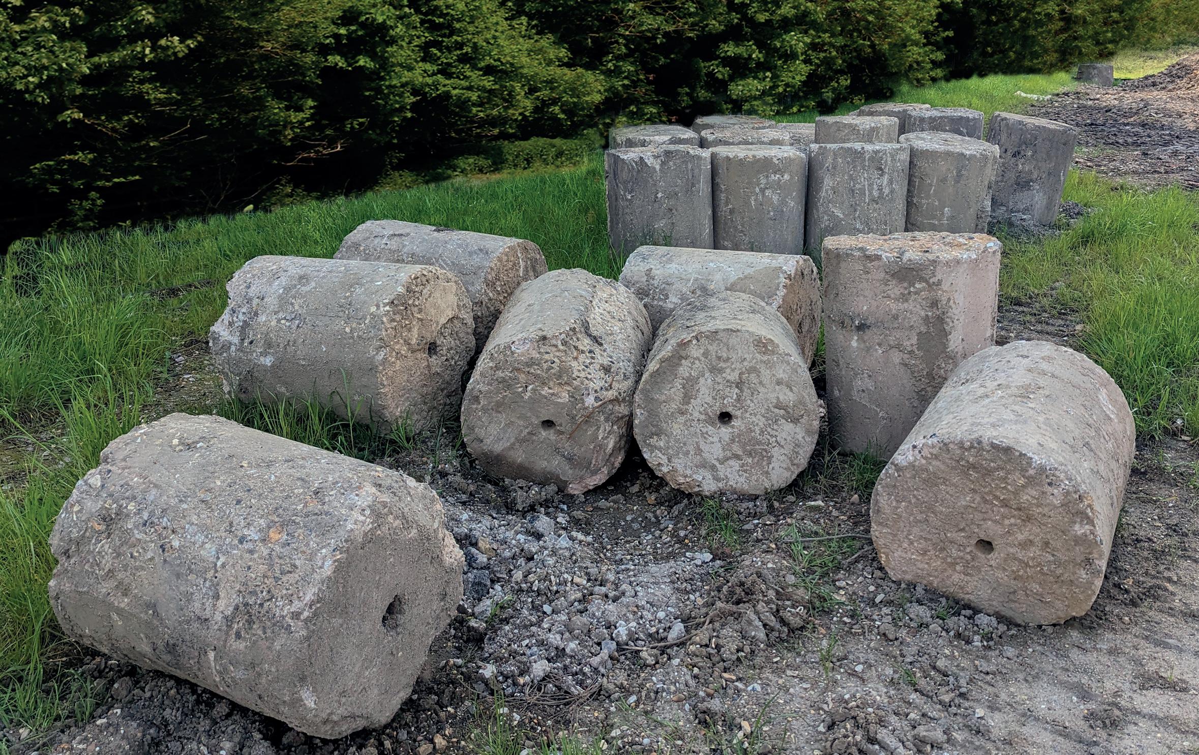
place, provide the rest of the barricade. BELOW: photo: © Historic Military Press | A batch of the anti-tank blocks uncovered at Bellway’s Bepton Road site on 9 May 2024.
transport links and communication centres. The stop-line defenders were to be withdrawn to strengthen the local mobile reserves that would garrison the nodal points in the event of an attack.
A report from the Ministry of Home Security dated 13 December 1941, reveals how these defensive locations were classified into two types – Category ‘A’ and Category ‘B’. The former were expected to hold out for seven days, while the latter were to resist an assault for at least two days. Ominously, the report’s author also concluded that in the event of an invasion, ‘these places may be isolated and subject to siege conditions’.3
Midhurst, by virtue of its position on the A272, as well as the road north from Chichester and the coast over the South Downs, was, according to a list dated June 1942, one of twenty-four places in West Sussex nominated to be Category ‘A’ nodal points. The same list notes that there were only five Category ‘B’ locations in the county, this, presumably, being a reflection of its proximity to the potential invasion beaches. The level of importance assigned to Midhurst’s defences can be seen by the fact that they were, as one of South Eastern Command’s Category ‘A’ nodal points, given ‘first priority’ in terms of such construction materials as were available.
Midhurst was still listed as a Category ‘A’ nodal point in an appendix attached to the West Sussex Standing Operational Order No.2, dated July 1943. Along with other nodal points and important locations such as airfields and ports, Midhurst had also been assigned a code-name which was to be used by the military and civil authorities in the event of an attack – Vienna. 4
There was no definitive plan as to how a nodal point’s defences should be arranged or constructed, aside from the fact that they should always utilise existing buildings and natural features in the landscape, including, of course, local waterways. Houses and shops would have been turned into improvised strong-points, loop-holes cut in walls, or rivers revetted to create anti-tank obstacles. Invariably, barbed wire barricades were erected around the perimeter of a nodal point, anti-glider obstacles scattered on surrounding open fields,
and bridges wired for demolition. As with the stop-lines, concrete inevitably played its part, with new or additional pillboxes being added, as well untold numbers of anti-tank blocks. The latter varied in design from the large cube-type blocks, each weighing a couple of tons apiece, through the various cylindrical drum-type blocks, to the smaller pyramidal ‘dragon’s teeth’ and cone varieties.
Sadly, no map or list of Midhurst’s defences is known to have survived. However, Les Howell, a young resident of Midhurst in the war and a keen member of its Air Training Corps, once recalled their presence: ‘It is very difficult for anyone who did not live through it to realise the impact total war made. It dominated one’s whole life. With the threat of invasion in May 1940, the town became a “nodal point” in the third line of defence. It was to be held “at all costs”, being surrounded by tank traps and barbed wire.
‘For example, there were barbed wire entanglements across the White City.5 Civilians were not to retreat but to stay put. To this end, every third or fourth house was strengthened with stout posts and beams to offer protection should a battle for Midhurst take place. Invasion shelters of concrete were also dug on St Anne’s [sic] Hill.’6
In time, as the threat of any meaningful German assault dwindled, some of the defences became more of a risk to those they were intended to protect. Serving in Midhurst’s National Fire Service unit, David Gibbs had been given a motorcycle to enable him to locate fires and other incidents and then ring the Station at the Old Town Hall, or return to it if no phone was available near the scene.
‘Around D-Day I had a motorcycle accident,’ he once revealed. ‘You know where that little cottage is which is a toll house [near the Half Moon Pub] along the Petersfield Road? Well, there they had two concrete tank traps, great big blocks. Four foot square, and they were [arranged in such a way] so a tank couldn’t get through. They had been there for quite a while, not just for D-Day.…
‘Well, I’m going along there happy as can be and I saw this thing coming, so I put my throttle down and the cable broke. I went straight into one of these
blocks hitting my knee against it. I broke my kneecap. The extraordinary thing is it was in the evening and nobody came for over an hour … They had several tank traps in the area. Sometimes they were round, sometimes they were square, but the whole object was they were a chicane – a tank can’t cope with that, you see.’7
The end of the war in Europe in 1945 made Midhurst’s defences redundant, and their removal became a priority. Generally speaking, this was a task that central government handed down to local councils and authorities. In the years after the war local residents recalled stories of some of the anti-tank blocks being dumped at a site off Bepton Road –this being part of the area that is currently being developed for houses by Bellway. The northern part of the site was a brickworks from 1913 to 1985, while the southern part of the site came to be used as a West Sussex County Council depot.
The rumours of the anti-tank blocks’ existence were proven true when some of them, approximately ten in number, were unearthed on the site. In the weeks since the first finds, further batches of these drum-style concrete blocks were uncovered and with the support of Bellway they will be persevered for future generations.
Photo: © Historic Military Press - A number of other wartime relics have been unearthed at Bellway’s Bepton Road site, including the two battered British Army helmets being held up for the camera by Justine Hope.
Photo: © Alamy - The many roadblocks established across Britain in the war took many forms, as this view of a car negotiating a barricade comprising square concrete blocks on Warnham Road, Horsham, on 26 June 1940, testifies.
Photo: © Alamy - Another view of Local Defence Volunteers on duty at the roadblock at Vale Farm, Findon, on 26 June 1940.

REFERENCES:
1. Henry Wills, Pillboxes: A Study of UK Defences 1940 (Leo Cooper, 1985), p10
2. Mike Osborne, Pillboxes of Britain and Ireland (Tempus, Stroud, 2008), p75
3. The National Archives (TNA), WO 199/544
4. TNA, WO 166/11008
5. White City: then housing, now the location of Sainsbury's supermarket
6. LS Howells, ‘The Way it Was Then: 1939-1945, Midhurst at War’, The Midhurst Magazine, No 1, Vol 2 Autumn 1989
7. Selham Airfield Project, oral history interview
MARTIN MACE has been involved in writing and publishing military history for over 35 years. Having launched Britain at War Magazine, which became the best-selling military history periodical on the high street, Martin still devotes his time to writing and publishing books, as well as recording the wartime history of West Sussex.


