


Channelized rivers are somewhat ubiquitous elements of the greater Los Angeles landscape. The LA River has recieved significant attention over the past few decades, but the reality is that it is but one example of the status quo for water management in the region.
As part of a community vision plan developed for our 3rd year studio for the city of Baldwin Park, I wanted to reframe the city’s own channelized river as less of an infrastructure eyesore and more as an asset to be seen and engaged with.


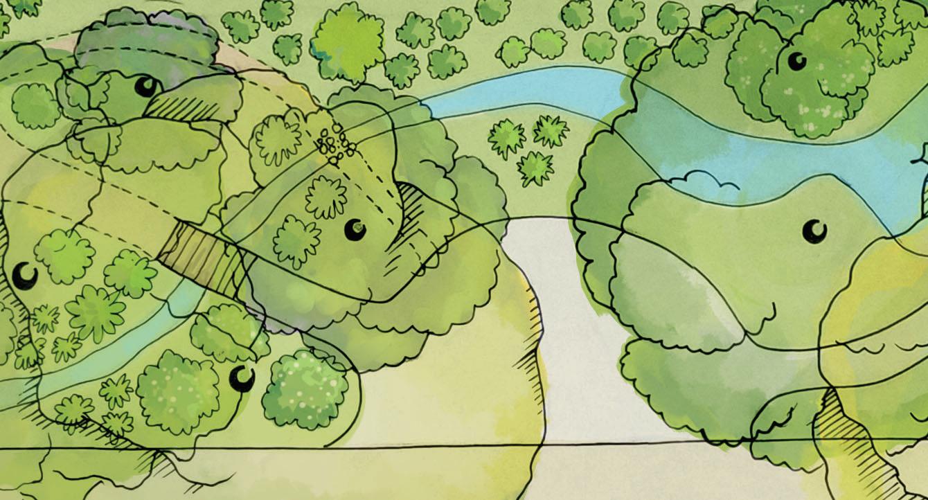
City context: The Dalton Wash District (blue) is one identified as a character zone within our greater Baldwin Park city final studio project. The District centers around the wash channel running roughly north to south.

Neighborhood context: My site design relates the Dalton Wash channel to the parcel of a closed elementary school. Schools are the largest green spaces within Baldwin Park, and this one is situated at a point of connection between BPHS, the Teen Center, Downtown, and the Metrolink.
My focus area aims to build in greater connectivity around the wash with the knowledge that the city plans to construct a bike trail along the entire length of the wash. I suggest additional bike infrastructure that allows safe and inviting access into that trail, while uplifting the image of the river and drawing attention to issues of urban environmental management.


existing condition with turf, few trees, extensive hardscape
Site condition and revision: . This design incorporates adaptive reuse of site features and shaping topograhpy to create a green node along a river channel.
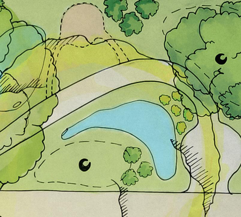
45% of impervious space removed, 6300 cuft (41000 gal) less runoff


filtration capacity added through large, shallow* swale 52600 of in added shallo enhanced ecosystem services and neighborhood circulation
52600 cuft (400000 gal)

*avg. 1’ depth


The soon-to-close Central Elementary School is the hub of my focus area within the Dalton Wash area. Parallel wash channel in the vicinity of both Hilda S. Solis Park and Teen Center and the enormous campus of Balwin Park High School, I want to use this parcel to bring a unique destination to the neighborhood, a multi-use park which showcases green infrastructure and sustainability within the often-homogenous sprawl of the LA metro area.
The programming improves the ecological value of the site while providing opportunities for environmental education restoration, relaxing social gathering, and community building.


Tujunga Wash near Burbank, CA is an example of a revitalized but still-channelized LA river. The easement is converted to native plantings, and the water is diverted into a 1.2 mile swale to capture extra water. The grade in Dalton Wash (bottom) is stronger than in Tujunga Wash (top). The wash is also home to one of the longest murals in the world, a great inspiration for community art utilizing a wash channel.


Rivers in Europe have been the focus of revitalization efforts to great effect in recent history. This channel in France demonstrates that a more natural look can be achieved even when the channel itself cannot be dismantled Here, gravel and soil in a geotextile is used to support vegetation in the channel.
(photos - 2018 Pansera Jean-Noël)


This vision emphasizes the value that can be gained from thinking of sites as pieces of broader social, environmental, and economic puzzles. The combination of features at the former school parcel and along the wash channel bring improvement to the “big picture” through layered bene


1
Urban waters:
The park swale holds water from rainfall on-site as well as a portion of the runoff from nearby storm drains that otherwise releases directly into Big Dalton Wash. Graywater can also travel into the basin from the on-site bathroom.
The channel has a new, natural aesthetic with the addition of gravel beds and plants, without concrete removal.
Routes to explore:
Pedestrian circulation within and around the site offer visitors many options to enter and explore the space. Students from Baldwin Park High can access through a new corner entrance (top left), and pedestrian access is incorporated along the wash on the bank opposite the bike trail.
INFILTRATION SWALE
1
Social or secluded:
A variety of spaces within the park allow people to gather socially with their loved ones, or with the community at large, or to get some distance with secluded seating.


NATURALISTIC
CHANNEL
4
Local economy: Reuse of the central plaza of the school converts the space into a multi-use area where events, art sales, and farmers markets can be hosted. When not hosting events, the space is seating for cafe visitors and park-goers.


5
Adaptive reuse: This plan removes hardscaping to adapt existing structure to the new site. Some parking and asphalt is retained to increase accessibility and usability. As these spaces degrade over time, they can be gradually replaced with permeable hardscape.

A bridge for all: The new pedestrian and bike bridge is an important upgrade on the current outdated, non-ADA footbridge at this location. Crossing points off of busy streets increase safe, efficient accessibility.
CPP MLA STUDIO. FALL 2023
Collaborative for Healthy, Inclusive Learning Environments (CHILE)


The CPPLA CHILE Studio offers a community-led design studio, matching students with schools and other public institutions to cocreate outdoor spaces that facilitate learning and physical- and mental health. My studio group worked with Rialto High School students and faculty to understand how their campus could use design practices to revitalizew a sense of community and wellbeing. For more about CHILE, see https://www.cpp.edu/env/lyle/chile/


Multifunctional spaces and wellness: Typical modern land use segregates the landscape into singlepurpose spaces. I wanted to illustrate through this graphic that reintegrating biodiversity and ecosystem function, food cultivation and engagement with the biosphere, cultivates wellbeing through attention restoration, physical activity, health, and socialization.


3 4


carbon sequestration forest
meditation path


8 elementary schools
cistern
citrus grove
CA native garden
vegetable garden

Resilience programs exist in multiple forms at every Rialto USD campus that produces the Rialto High School study body.

2 middle schools

1 Rialto High School

These schools, alongside Rialto HS, are part of a district-wide effort to promote wellness, sustainability, and environmental education. Each school has its own programs to engage students with age-appropriate, hands on education. Rialto High is the final station for youth in the community to cement and carry this education and wisdom out into the world as young adults.
However, post-pandemic, we found Rialto’s programming in a state of neglect:
commitment to the future in a stressed world
The meditation garden was closed down, with failed irrigation, erosion, and plants in disarray.

Citrus and carbon sequestration trees were found in an unassuming corner of the campus, with some trees left in pots.

A CA native garden was a bright spot of diversity on the school grounds, but we learned it was typically locked-up.


Rialto HS is located in a relatively park-poor region. There are no parks (green) within a 10-minute (0.5mi) walk of the school, making it an important location for its greenspace value. Unfortunately, the school grounds are fenced and not accessible outside of school hours under current conditions.
In addition to the community of people surrounding it, this school is an important location to the surrounding wildlife. The school is located on the former Delhi Sand Dunes formation (yellow), home to the first fly to be placed on the endangered species list, the Delhi sands flower-loving fly (Rhaphiomidas terminatus abdominalis).
The school feeds runoff towards the Santa Ana River. With nearly 70% of the school surface area impermeable, an inch of rain produces enough runoff for two full days worth of water supply for the entire 2844-person student body. Investing in water capture can restore some of this water to the community and local ecosystem.

Typical parks nearby are resourceintensive, uniform, and provide a monoculture of experience.
Map: Local parks (green) and RHS (blue) with a 0.5mile euclidian buffer approximating a 10-minute walk.

The Delhi sands fly requires dune habitat to reproduce. Only three percent of the dunes remain intact.
Map: The buried extent of the nearly-extinct Delhi sand dunes habitat, transformed by urbanization.

Water in
and quality loss is pervasive in Southern California. Green infrastructure can help.
Rialto Unified School District sustainability research by teammate Trinity Gomez. Photo top: Joe Sampson Park via googlemaps Matilda-DHum July 2022. Photo mid: Delhi Sands fly by Rivers and Lands Conservancy. Photo bottom: Santa Ana River Trail via googlemaps Richard Arias Sept 2023


Reduce percieved and physical barriers.
• pull fencing away from sidewalk where possible
• add additional access routes.


Provide hospitible spaces.
• create shelter from harsh weather through weatherproof shades and varied shade options
• increase seating


Provide students with choices.
• create both gathering and secluded spaces
• provide a variety of seating environments in sun, shade, open and closed designs
In my conceptual design I sought to address the factors that were contributing to this campus being a space that was somewhat hostile to students, while simultaneously attending to the environmental hostility posed by the campus design.
Each space is given some layer of purpose and intention when possible, with the goal of creating a more welcoming, engaging, sheltering space for students.
The addition of tree canopy, access paths, water infiltration, and publicly accessible space all serve dual functions of making the school approachable for people while improving its climate and its ecosystem services for the community.


Delhi sands habitat


Support ownership of the space by students.
• create outdoor classroom with student-tended habitat
• include native plants, trails to be cared for by students


green space and parks gathering spaces secluded spaces

Support the community.
• provide publicly accessible parks on underutilized space
• use green infrastructure to support water supply, reduce urban heat island, and support wildlife
Within the campus center is the opportunity to create spaces that are restorative to the senses.
This includes gathering places for students to have lunch or socialize, as well as a reimagined meditation garden and more private spaces within each of the four courtyards designated for each year.


Opportunities for improved ecosystem services exist here also.
We noticed an extensive drainage system constructed to manage what must be significant runoff from the approximately 70% paved surfaces of the campus.
112, 500 cuft of runoff could be captured from 1” of rain.
 Lunch common areas incorporate concrete removal and plantings to encourage students to slow down and be more present. Fruit trees offer seasonal interest as well as potential snacks.
The meditation garden has been subdivided from a large, open, privacyfenced rectangular space, into one with rooms of differing size created with seat walls and plantings to add privacy while mantaining permeability.
Mini-quads exist for each grade level. With seating, rain gardens, and diverse plantings replacing turf, these gain utility and interest.
Lunch common areas incorporate concrete removal and plantings to encourage students to slow down and be more present. Fruit trees offer seasonal interest as well as potential snacks.
The meditation garden has been subdivided from a large, open, privacyfenced rectangular space, into one with rooms of differing size created with seat walls and plantings to add privacy while mantaining permeability.
Mini-quads exist for each grade level. With seating, rain gardens, and diverse plantings replacing turf, these gain utility and interest.

Between baseball fields exists a major opportunity to add campus access, which is currently restricted to two corners of the city block it occupies. This can be made more functional and enjoyable by converting the paved drainage channel to an equivalent-size bioswale.


Underutilized space can be harnessed to beautify the campus while incorporating ecosystem services, supporting living systems and the regional water supply.

My first studio assignment was to imagine a significant landscape for my childhood. For me, that was anywhere in “my” backyard, which extended to anywhere I could easily ride my bicycle to as a small child.
Thinking about my formative experiences, interacting with nature and the wild world heavily shaped who I am today. The creek behind my former elementary school represents that experience. I recall turning over rocks, finding salamanders and crayfish. My school is still there next to the creek. My goal was to translate this experience to one children could access as part of their school day, right outside their door.

 Model: Above and right is a 1-foot square model of my childhood creek. I wanted to capture the textures, red clay soil, and canopy roof as I bent down into the stream.

These plan and section views illustrate my vision of a restorative play space with room for imagination and choice-making.


berms enclose outdoor reading space


non-prescriptive play equipment


I wanted to offer students more than typical playground equipment, turf, and a running track. This space offers trees to hug, logs to climb, a stream to ford, as well as both hard and soft paths over a variety of terrain challenges, leading to both group and individual spaces. Use of native plants and the stormwater swale offer opportunitys for early environmental education.


restorative views


mixed native vegetation


Sketching on-site is an important practice for developing the ability to translate 3D space into a 2D representation.
This sketch is from Villa d’Este, in Tivoli Italy outside of Rome. I wanted to capture the sense of slope down through the archway and into the view beyond.
Opposite: Illustration of Building 1, CalPoly Pomona. Ink and Admarker on trace paper.
I have always enjoyed illustration with traditional and digital media. Finding this career has allowed me to combine my artistic, scientific, and cultural interests.
This is a watercolor of Arlington Garden in Pasadena, CA. Taking inspiration from impressionism has encouraged me to losen up from my default technical style and to educate myself about color theory.


These pieces are taken from a project in which with artifically generated a random topography to represent a wetland, with an analogue to the Bolsa Chica wetland area south of Los Angeles. We were tasked with constructing both physical and virtual models of this tophography.
The image pair to the left and the pair below that show how I was able to make use of the Rhino model to produce renders in Adobe Photoshop. The renders are composite imagery with source photo material collected from site visits to Bolsa Chica.
The Rhino model is shown at the bottom is colored to indicate water levels and distinguish them from the built structures. We sought to make use of natural islands as anchors to our built structures, and restricted built platforms to hug close to these structures, with access boardwalks taking visitors out over the wetland, allowing them to see the landscape for themselves.


Beginner (easiest) trails:
This geodesign assignment asked us to locate mountain biking trails by using a model constructed to connect 14 landmarks and trail exits. Starting from NED elevation data, slope was calculated for the site, with trails constructed using a cost-distance tool to minimize total slope cost. Polylines constructed postanalysis were then binned into three levels of difficulty, and loop paths were identified for each difficulty level.

• low average slope intensity (less than 5% )
• mild variation in slope (maximum 10%)
• loop trail (1) accesses main trail exit/entry point while passive over a peak and POI
Advanced-Beginner (easy) trails:
• average slope intensity under 5%
• maximum slopes between 10% and 15%
• loop trail (2) alternates between beginner and more intense trail segments, with access to the main trail exit
Novice (more difficult) trails:
• average intensity up to 10% slope
• segments with >15% slope
• loop trail (3) connects to multiple POI, accesses roadway


loop
loop


Topanga State Park is a significant public open space in the eastern Santa Monica Mountains for both people and wildlife. We were tasked with identifying locations for future facilities and permanent infrastructure, as well as locations which were suitable for light recreational use.
Assessment of topography was an important first step, as this determines which locations are the safest for construction of buildings and for use by visitors. We mapped elevation and generated slope data from the resulting contours. These show that the most level areas of land are concentrated at the rolling crests of the hills in the park.
From there we layered land cover information to highlight which habitats are rare or common in the landscape. Chaparral shrub covered the majority, with a diverse patch to the west and hardwoods concentrated around water.
Taken together, we selected three locations for heavy use, where bathroom facilities and other structures may be appropriate, as well as two locations for light recreation via trails for pedestrians, equestrians, and bicyclists. Recreation areas have moderate variation in terrain and bring visitors to multiple land cover types, allowing them to see greater biodiversity in the space.
All areas chosen avoid conflict with the two SEA’s delineated in the east.
Light recreation zone


Park
CalPoly Pomona MLA’24 UCLA MSc’18
hstansell@cpp.edu


