Principles On Responsible Inhabitation of Wetlands
 Hayden C. Blodgett

Hayden C. Blodgett
The practical problem explored in this study is the alleged incomparability of human inhabitation and the ecological integrity of wetlands.
This research explores the current state of human inhabitation of wetlands, which involves destroying ecosystems, endangering many wetland species, disrupting natural filtration of water in these areas, and increasing storm surge flooding in residential areas. Ideally, there are strategies to maintain the integrity of wetlands while allowing for responsible human inhabitation of these areas. This research presupposes that humans and the environment have a symbiotic relationship that is both casual and relational.
Hayden C. BlodgettFor the purposes of this research, the concept of “responsible inhabitation” is defined as the when human inhabitation is at the intersection of “resilience” and “stewardship.”
The Stockholm Resilience Center holds that modern societies must be resilient to handle the increasingly-present challenges of climate change.“Resilience thinking investigates how interacting systems of people and nature can best be managed,” and this is how societies can increase their readiness for challenges.
“All seven principles [of Resilience Thinking] require a nuanced understanding of how, where and when to apply them.” The principles are: (1) Maintain diversity and redundancy, (2) Manage connectivity, (3) Manage slow variables and feedbacks, (4) Foster complex adaptive systems thinking, (5) Encourage learning, (6) Broaden participation, and (7) Promote polycentric governance. Together, these pillars increase a population’s resilience.
The National Oceanic and Atmospheric Administration (an arm of the US Department of Commerce) employs the term “Environmental Stewardship” as defined by Chapin et al. Meaning “the responsible use and protection of the natural environment through conservation and sustainable practices to enhance ecosystem resilience and human well-being.”
For the purposes of avoiding circular logic, this definition will be adapted for this project by becoming, “the non-destructive use of lands and protection of significant natural environments through conservation and sustainable practices to preserve existing/evolving ecosystems and serve overall human well-being.”

Wetlands are defined by the British Columbia Ministry of Forest Research as, “areas where a water table is at, near, or just above the surface and where soils are water-saturated for a sufficient length of time such that excess water and resulting low soil oxygen levels are principal determinants of vegetation and soil development,” and they serve critical functions as the foundation of ecosystems and as defensive barriers between human populations and natural disasters.
Historically, “wetlands were regarded by most people [in industrializing societies] as wastelands, whose best use could only be attained through alteration, (e .g., draining for agriculture, dredging and filling for industrial and housing developments and filling with sanitary landfill).” Since the environmentalist movement in the 1960s, however, “scientific studies demonstrating wetland values, especially for coastal marshes, [have been] instrumental in increasing public awareness of wetland benefits and stimulating concern for wetland protection.” This has prompted most governing bodies to pass legislation for the protection and/or restoration of wetlands in their jurisdictions.
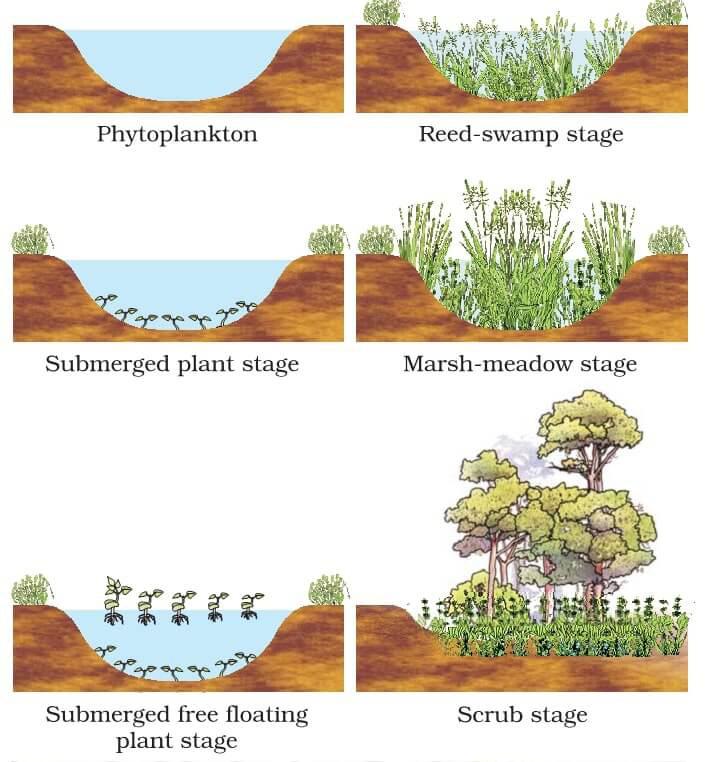
Wetlands (like other environments) are subject to ecological succession, which is responsible for the natural evolution of ecosystems from one form (such as a marsh) to another (such as a wet meadow). Succession takes two forms: Primary (a predictable linear progression) and Secondary (a less predictable progression set in motion by disturbances to the ecosystems), where Secondary Succession takes place within the larger process of Primary Succession.
Given human intervention, wetlands can be converted into other types of land. Examining these interventions through the “resilience thinking” lens shows that human intervention is instigator for transitions between land types and that as land transitions by human intervention, it often becomes less resilient to disasters meaning that as humans exercise poor stewardship, land becomes less resilient. This depicts the relationship between land/ecosystem resilience, and human stewardship.

Human Intervention
High Resilience
Human Intervention
Low Resilience
Every case study evaulated during research was able to be viewed through the lens of stakeholders and their contributions to problems/ solutions. The five main stakeholders are (in order of most land-interested to most self-interested) Preservationists, Researchers, Policy Makers, Populations, and Capitalists. These labels are not intended as pejoratives, but as descriptive titles.
Preservationists are driven to preserve natural/ current conditions without human intervention.
Preservationists see wetlands as something as entities to be protected from human intervention.
Preservationists often work in tandem with researchers, but are more concerned with protecting the areas than learning from them.
Researchers are driven to study and understand natural/current conditions.
Researchers closely interact with wetlands to observe/study a wide range of scientific conditions (biological, ecological, etc.).
Researchers often work in tandem with preservationists, but are more concerned with learning from the areas than preserving them.
Policy Makers act as the “neutral” stakeholder, because they are beholden to will of the public—which varies by shifting from a land oriented view to a profit oriented view and vice versa.
Policy Makers have the authority to favor and amplify the practices of the other stakeholders.
Populations are driven by their needs.
When populations are prospering, they can devote resources to things like preservation and research, but when given the choice between a population’s immediate well being and the protection of the environment, populations protect themselves first.
Capitalists are driven by the opportunity for profit.
Capitalists are seldom doing intentional harm to the environment, but the environmental consequences of their actions are often seen as given the opportunity for profit.


The District of Columbia was originally a 10x10 mile square set along the wetlands/ estuary of the Potomac and Anacostia Rivers. The L’Enfant Plan (upon which the city was based) ignored the role of wetlands and the natural mudflats that would become the city. Because of this, construction went forth with few mitigation efforts or consciousness to flood planes. In the late 19th and early 20th Centuries, what wetlands remained were infilled for the purpose of mosquito mitigation, resulting in the destruction roughly 90% of the original tidal wetlands and their ecosystems.


Over the course of the last two centuries, climate change and its effects have exacerbated the issues that L’Enfant Plan produced. Today, many buildings/areas containing key national resources, documents, and other artifacts such as the Smithsonian Institute, National Archive, Department of Justice, Department of Commerce, Internal Revenue Building, Environmental Protection Agency, and others are located in Washington, D.C.’s “flood risk zones.”
In recent years D.C. has dedicated major resources to restoring destroyed wetlands. New parks are restoring wetland habitats and are intended to serve as the first line of defense against future flooding. The Kenilworth marshes along the Anacostia Mudflats have already been successfully restored with dredge material from the rivers and the replanting of native plants. The Kenilworth restoration has already restored the natural tidal flow of the Anacostia River basin and, “linked academia with restoration practitioners,” that will help boost support for current/future restoration efforts.

 Hayden C. Blodgett

Boston’s Back Bay was originally a tidal estuary, dammed by a mill company in the early 19th Century for use as a tidal basin. As industry grew, the basin was severely polluted and a particularly festering area within it known as the Fenway Flats was notorious for being, “a body of water so foul,” that they were a danger to the public and the people of Boston demanded a solution.
In 1879, Frederick Law Olmsted designed Boston’s “Emerald Necklace” network of parks. Among those parks, was Back Bay Fens—which, “proposed to flush out the stagnant waterway and add naturalistic plantings to emulate the original tide marsh ecology of the Fenway area.” The converted the polluted marsh from a public health hazard into a public asset of an “urban wild” wetland.


During Colonial times, the area was a picturesque “salt meadow”marsh, but by the early 19th Century, the Fenway Flats had been decimated into, Olmsted’s design worked with the natural conditions of New England’s salt marshes to create an aesthetically/ emotionally pleasing and ecologically functional wetland within the city fabric of Boston.
Other projects in the city, however, have shifted Back Bay Fens away from Olmsted’s original vision. The, “damming of the Charles River changed the water here from brackish to fresh, rendering [Olmsted’s] plantings unsupportable,” and many of the original bridges and strong trees have been replaced or removed. Regardless, Back Bay Fens remains a well integrated piece of wetland design in the overall urban framework of Boston, which has allowed the city to thrive and offers residents a place of clean air, clean water, and mental reflection in a city-supported greenspace.
 Major Stakeholders: Populations, Policy Makers, Capitalists
Hayden C. Blodgett
Major Stakeholders: Populations, Policy Makers, Capitalists
Hayden C. Blodgett
In 1928, the Tamiami Trail was completed—forming the first trans-peninsula highway connecting Tampa to Miami. Considered a “feat of engineering” at its debut, it dammed the “River of Grass” by cutting through Big Cypress and Everglades National Parks, creating an ecological disaster that dried out much of the surrounding land and destroyed many unique ecosystems.


By the 1950s, the negative impact from the disruption of the Everglades had become apparent and water disruption was detectable in failing ecosystems across the Floridian Peninsula. Organizations such as the Everglades Society and the Sierra Club began
In 2003 the US Army Corps of Engineers recommended the replacement of a onemile stretch of the highway with an elevated causeway that would restore the natural waterfowl in the Everglades. This was intended to serve as a test model for other similar restoration projects.


The “Everglades Skyway” opened in 2013, proving that such a restorative undertaking is realistic on a large scale. Environmental activist groups and scientists are pushing for further projects. The Florida Chapter of the Sierra Club is lobbying for more interest and action to be taken quickly because, “time is what is in short supply for the Everglades.“
Climate change is accelerating and, “the Skyway is [Florida’s] best weapon to stave off the effects of sea level rise. The road must be lifted quickly and sufficient clean water must pass underneath so fresh water can hydrate the aquifer and the soil. Otherwise, Everglades National Park will fall to the salt-water sea.”


In the late 1960s, the Walt Disney Company was searching to expand its park experiences to the eastern United States by developing a resort on central Florida.


At the time Orlando was medium sized city at the intersection of interstates, but the surrounding area was primarily wetlands previously slated for agricultural and residential developments by the Army Corps of Engineers.
As Walt Disney Co. bought up large amounts of land, the state government of Florida took an interest in the development of the area and took steps to ensure that a percentage of the area would be dedicated to conserving the natural environment. through a partnership with the state government and The Nature Conservancy.

The result was a 8,500 acre property in Kissimmee, Florida known as “The Disney Wilderness Preserve,” (DWP) owned by the Walt Disney Co. and operated by the Nature Conservancy. The preserve has turned the area from a cattle farm into restored natural wetlands and has served as a wildlife sanctuary that has been a mainstay of centralFloridian wetland conservation for over four decades.
While the establishment of the DWP has been an amazing ecological resource for the state of Florida, the Walt Disney World Resort still covers +25,000 acres of former central-Florida wetlands. The fact that the property is not on the coast means that the immediate threat to any human population is less evident than other case studies evaluated, but the overall destruction of native wetland habitats was significant.


Step by step of the Katrina’s effects:
1. High tides swelled Lake Ponchartrain
2. Levees on the eastern side of Industrial Canal fail - triggering 95% flooding of the residential areas in the Lower 9th Ward (former wetlands)
3. St. Bernard Wetlands flood, holding floodwaters back from five major neighborhoods for three more hours
4. New Orleans East (former wetlands) floods after levees fail on all sides
5. Levees on the western side of Industrial Canal fail - flooding the residential areas in the Desire, St. Claude, St. Roch, and the 7th Ward
6. Lake Borgne spills over the St. Bernard Wetlands and floods the rest of the area
The US Army Corps of Engineers described the 2005 flood-defense system as “a system in name only” because it neglected to operate cohesively to protect the city. It is estimated that as much as 65% of all flooding during Katrina was due to design flaws instead of the storm intensity. The St. Bernard’s Wetlands were intended to act as eastern/lower New Orleans’s first line of defense in the event of flooding, but there were easily overwhelmed and the auxiliary levee “system” failed due to state negligence.
The Louisiana Department of Wildlife & Fisheries has concluded that, “more than 95 percent of Louisiana’s forested ridge habitats has been lost since European settlement,” which is, “a huge loss for coastal Louisiana because ridges play an important role in our coastal ecosystems by balancing how water moves and preventing saltwater intrusion that can lead to land loss.”
St. Bernard’s Wetlands have been a point of particular restoration effort in recent years. Areas such as the Bayou La Loutre Ridge are undergoing wetland restoration which is intended to restore natural ecosystems and increase the city’s flood resistance.
Major Stakeholders: Policy Makers, Populations

 Hayden C. Blodgett


Situated on an “environmentally significant peninsula” on the northern end of St. Simon’s Island, Georgia is +700 acre property known as Cannon’s Point Preserve. The property was first developed as the Cannon’s Point Plantation in the late 18th Century, and the land was farmed for most of the next hundred years. After Reconstruction, the property fell into disrepair and was abandoned for decades.
In 2012, 608 acres were purchased by the St. Simon’s Land Trust (SSLT), which granted The Nature Conservancy (TNC) a conservation easement that will protect the property from development into perpetuity. In the decade since then, additional acreage has been added to the Preserve by a National Coastal Wetland Conservation Grant from the US Fish and Wildlife Service administered by the Georgia DNR’s Wildlife Conservation Section. The Preserve is now more than “700 acres of permanently protected maritime forest, salt marsh, tidal creek and river shoreline that provide habitat for wildlife such as oysters, birds, fish, and manatee.”
In addition to providing a protected habitat for 95% of “native species in Georgia not fished for or hunted, plus rare plants and natural habitats,” the Preserve has become an education center, teaching the importance of wetland preservation, and a cultural center, allowing visitors to explore the ruins of the Cannon’s Point Plantation and allowing local Gullah populations to showcase/teach their traditions and customs to tourists and residents alike.

Through evaluation of the case studies, multiple principles emerged—either by example or by counter-example—to guide planning for future wetland inhabitation and interventions for current degraded wetlands.
1. In-depth Understanding of the Existing Ecosystems
The first principle that emerged is based on the obvious need to understand the environment being built into. By doing thoughtful research during site analysis for design projects, ecosystems can be carefully responded and adapted to in ways that allow them to continue to serve an ecological purpose that will protect both human and other populations.
Case Study Example
The New Orleans Hurricane Response System was drastically uninformed, costing of 1,800 human lives.
2.
The second principle emerged from the need to maintain significant waterlfow in wetland areas. This works both to maintain plant/animal life within delicate wetlands ecosystems and provide a flood diversion path away from human population centers.
The Tamiami Trail bridge failed to allow waterflow between the upper and lower Everglades, triggering many ecological failures.
3. Leave Flood-Zones Uninhabited
The third principle emerged from the clear need to keep human population centers away from flood zones. Many governments have established flood-planes that cannot be built upon, but these conditions need to be significantly expanded to allow for wetland development as increased flood-buffers and protect populations from costly flooding.
4. Preserved-lands in Development
The fourth principle expands the idea that development necessitates preservation. The establishment of a percentagebased system that requires a certain amount of preserved-lands for all new development will preserve a base-line amount of wetland ecosystems, create research opportunities/protections for wetland species, and flood-protection for human population centers.
5.Interweaving of Built Environment with Native Conditions
The fifth principle merges human inhabitation with native wetlands. By integrating native wetlands (and subsequently native flora and fauna) into existing/forthcoming urban frameworks, wetland ecological integrity can be at least partially maintained and adapted to protect native species, allow for public greenspaces, and bolster flood mitigation networks.
The Washington, DC master plan placed the entire Federal Triangle within a critical high-risk flood zone.
The Cannon’s Point Preserve and DWP place designating preserves within the development process.
Case Study Example
Back Bay Fens & The Emerald Necklace integrate natural conditions with their new urban environments.
Moving forward, a pragmatic approach demands that major involved stakeholders place value on these principles. Researchers and Preservationists already place high value on the conservation of wetland integrity, but Policy Makers, Populations, and Capitalists are the major drivers of societal change. Since the 1960s, Researchers and Preservationists have been positively acknowledged by Populations and Policy Makers, but ultimately their goals have been misaligned with the immediate needs of Populations—which has left Policy Makers with little incentive to act in the interests of wetlands.
Finding economically viable ways to implement these principles is critical to the long term responsible inhabitation of wetlands. These ways may come naturally as the net cost of continued rebuilding from hurricanes, flooding, and other natural disasters outweighs the cost of systematic/partial implementation of theses principles, but economic viability may be accelerated through a proactive approach on behalf of Policy Makers. By offering wetland-responsibility tax incentives or increasing regulations for land developers, a baseline amount of progress can be implemented.
It is in implementation of these principles that the importance of “polycentric governance” is revealed. Local governments, state governments, national governments, and international governing bodies can each accomplish specified goals based on the size of their jurisdiction. By setting baseline standards at (inter)national levels, Policy Makers can ensure consistent goals, but by allowing localized governments to set higher level standards and specify the amounts of tax incentives or penalty for breaking regulation, each local body can take a specialized approach towards solving their individualized issues.
Banner, Allen, and Will MacKenzie. 2000. “The Ecology of Wetland Ecosystems.” Prince Rupert Forest Region, British Columbia, Canada: B.C. Ministry of Forests Research Branch. Brown, Brian. 2017. “Cannon’s Point, St. Simon’s Island.” Vanishing Georgia. Vanishing Georgia. December 18, 2017. https://vanishinggeorgia.com/2017/12/18/cannons-point-st-simons-island/.
City of Boston Parks & Recreation. 2016. “Back Bay Fens.” Boston.gov. City of Boston Parks & Recreation. July 14, 2016. https://www.boston.gov/parks/back-bay-fens.
Dahl, Thomas, and Gregory Allord. 2000. “History of Wetlands in the Conterminous United States.” Washington, DC: US Geological Survey.
DC Department of Energy & Environment. n.d. “Habitat Restoration - Wetland Restoration Projects | Ddoe.” Doee.dc.gov. DC Department of Energy & Environment. Accessed October 3, 2022. https://doee.dc.gov/ service/habitat-restoration-wetland-restoration-projects.
Editor, DAN SWENSON | Graphics. 2019. “Flood-Katrina-Map.jpg.” NOLA.com. NOLA. August 20, 2019. https://www.nola.com/image_6a3a0a22-c37b-11e9-867c-037f316a3170.html.
Leibacher, Herb. 2014. “Have You Ever Visited the Disney Swamp?” World of Walt. World Of Walt. November 17, 2014. https://worldofwalt.com/disney-wilderness-preserve-swamp.html. Moseley, Kendra. 2018. “Wetland Ecology – Basic Principles.” Washington, DC: US Department of Agriculture.
National Oceanic & Atmospheric Administration. 2022. “Stewardship Definitions | National Oceanic and Atmospheric Administration.” Www.noaa.gov. US Department of Commerce. October 13, 2022. https://www. noaa.gov/office-education/noaa-education-council/monitoring-resources/common-measure-definitions/stewardship-definitions.
Nespral, Briana. 2022. “Walt Disney World and Florida, Partners since 1967, Seem to Be at Crossroads.” WPTV News Channel 5 West Palm. WPTV News Channel 5 West Palm. April 22, 2022. https://www.wptv.com/ news/state/the-history-behind-walt-disney-world.
Oskwarek, Ziggy. 2021. “Is a 5th Disney World Park Coming? A New Disney Park When?” ZiggyKnowsDisney.com. Ziggy Knows Disney. August 13, 2021. https://ziggyknowsdisney.com/wdw-5th-gate/. Pittman, Craig, Florida Phoenix August 19, and 2021. 2021. “Raising the Dam-Nable Road That Ruined Florida’s Everglades.” Florida Phoenix. Florida Phoenix. August 19, 2021. https://floridaphoenix.com/2021/08/19/ raising-the-dam-nable-road-that-ruined-floridas-everglades/.
Pontchartrain Conservancy. 2017. “Central Wetlands.” Pontchartrain Conservancy. Pontchartrain Conservancy. 2017. https://scienceforourcoast.org/pc-programs/coastal/coastal-projects/central-wetlands/.
Pruitt, Sarah. 2020. “How Levee Failures Made Hurricane Katrina a Bigger Disaster.” History. August 27, 2020. https://www.history.com/news/hurricane-katrina-levee-failures.
RESTORE the Mississippi River Delta. 2020. “This Ridge in St. Bernard Parish Is in Dire Need of Restoration.” Mississippiriverdelta.org. Restore the Mississippi River Delta. June 12, 2020. https://mississippiriverdelta.org/ this-ridge-in-st-bernard-is-in-dire-need-of-restoration/.
Santaniello, Neil. 2001. “TAMIAMI PROJECT to DIRECT WATER into THIRSTY EVERGLADES.” Orlando Sentinel. Orlando Sentinel. August 5, 2001. https://www.orlandosentinel.com/news/os-xpm-2001-08-050108050168-story.html.
St. Simon’s Land Trust. 2021. “100 Acres Added to Cannon’s Point Preserve.” St. Simons Land Trust. The Nature Conservancy. February 22, 2021. https://www.sslt.org/latest-news/100-acres-added-to-cannons-pointpreserve/.
Stockholm University. 2015. “Applying Resilience Thinking - Stockholm Resilience Centre.” Stockholmresilience.org. Stockholm University. February 19, 2015. https://www.stockholmresilience.org/research/researchnews/2015-02-19-applying-resilience-thinking.html.
Taylor, Alan. 2016. “The Restoration of the United States Capitol Dome - the Atlantic.” Www.theatlantic.com. The Atlantic. November 16, 2016. https://www.theatlantic.com/photo/2016/11/the-restoration-of-theunited-states-capitol-dome/507932/.
The Nature Conservancy. 2021. “Additional Protected Acres Added to Cannons Point Preserve on St. Simons Island, Georgia.” Nature.org. The Nature Conservancy. February 19, 2021. https://www.nature.org/en-us/ newsroom/100-acres-added-cannons-point-preserve-georgia/.
———. 2022. “Disney Wilderness Preserve.” Nature.org. The Nature Conservancy. 2022. https://www.nature.org/en-us/get-involved/how-to-help/places-we-protect/the-disney-wilderness-preserve/.
Tiner, Jr ., Ralph. 1984. “WETLANDS of the UNITED STATES : CURRENT STATUS and RECENT TRENDS.” Washington, DC: U .S . Fish and Wildlife Service. Ullman, Jonathan. 2013. “The Everglades One-Mile Bridge Is Only the Beginning.” Www.sierraclub.org. Sierra Club, Florida Chapter. March 20, 2013. https://www.sierraclub.org/florida/blog/2013/03/everglades-onemile-bridge-only-beginning.
Wetland Studies and Solutions. 2020. “DC Wetland Conservation Plan.” Wetland Studies and Solutions. Wetland Studies and Solutions Inc. November 16, 2020. https://www.wetlands.com/vol28-no14-dc-wetland-plan/. Younts Design Inc. 2022. “Ecological Restoration: Where It Has Been and Where It Is Going / the Evolving Practice of Ecological Restoration along the Nation’s.” Biohabitats. Biohabitats Inc. March 21, 2022. https:// www.biohabitats.com/newsletter/ecological-restoration-where-it-has-been-and-where-it-is-going/the-evolving-practice-of-ecological-restoration-along-the-nations-other-river/.