

LinkedIn: www.linkedin.com/in/chandana-k-03487652
M: (+91) 9669940405 Address: 59A Tungabhadra, Dollars Colony, Bengaluru, 560094
Architect Intern - 3 Months Design and execution of sustainable and contemporary residences, resort and Spa, Architectural guidelines for Conservation of Fort Kochi, Kerala Pucca local, Gopalpet, Telangana Intern - 3 Months Concept, Design and execution of sustainable vernacular prototype for Montessori, Hands on construction, Client handling, R&D, Site supervision
WORK QUALIFICATIONEDUCATIONINTERNSHIPEXPERIENCE&
E-Mail: chandana0110@gmail.com
Curriculum vitae
Client meetings, MEP and site coordination Budgeting, preparation of BOQs
CSBNE LLP, Kollam, Kerala (Ar. Eugene Pandala)
Chandana K • Mob: (+91) 9669940405 • Email: chandana0110@gmail.com r+d Studio, Gurgaon, Haryana
Enso Design, CR Park, New Delhi Intern - 3 Months Independently headed design and execution of exhibition pavilion in Rashtrapati Bhavan, New Delhi, ID, working drawings, model making Masters - Urban Design (2020 - 2022) School of Planning & Architecture, New Delhi | CGPA: 8.13/10 | Bachelors of Architecture (2013 - 2018) School of Planning & Architecture, New Delhi | CGPA: 7.27/10 |
Architect - 22 Months Lead architect of apartment interior design an apartment in DLF Camelias, Gurgaon Masterplanning and design ideation of school campus in Muddapur Design and preparation of working drawings
A strong believer of the sanskrit phrase “Vasudaiva Kumtumbakam” (the world is one family), I see urban design as a tool to re-connect people amidst the growing nuclearity in the world. An ardent traveller and a passionate musician, I have a quest to decode the rhythms of life to unravel untold stories. Coming from a multilingual background, I like to learn newer languages which helps me connect deeper with people.
Chandana K.
Languages: Hindi | English | Telugu | Marathi | Kannada
Projects: Residential + School India Lost and Found, New Delhi Research Lead - 5 Months Research lead and authenticator for monuments for Sitelens projects Built repository from online sources for Bibliography projects

Manifesto for a Just city workshop - TU Delft (Oct’21)
Quick learner and a work enthusiast
Introduction to Urban Design - AUD academy (Jul’20)
Understanding Urban Ecological Planning (Spring 2021) - Winter school NTNU Fostering Growth and Inclusion in Asia’s cities - Asian Development Bank (Jun’20)
Invited by SPA Bhopal to deliver a lecture on ‘Design Interventions in historic Guru ka Bazaar, Amritsar’ to M.Arch (Conservation) students (Jan’20) Chandana K, Monali B, Niharika G, Vishnupriya V (2022). DECENTRALIZED POWER CENTRE, in Rocco, R. & Newton, C. (2022), A Manifesto for the Just City (Vol. 2). Delft: TU Delft OPEN. | pg AvailableChandanahttps://issuu.com/robertorocco/docs/book_manifestos_2021_2nd_edition204-209K,2022.TheFlipSide–Inkling.[online]Blog.indialostandfound.com.at: https://blog.indialostandfound.com/2021/07/19/the-flip-side/ Book published on Vernacular ‘Vernacular Settlements in Chanderi’-Towards Innovation and Sustenance : a Collaborative Study by SPA, Bhopal and SMMCA, Nagpur
Certificate course on Research Methodology - INTACH Heritage Academy (Mar-Jul’22)
Research, Reading, Photography,
Efficient communication skills - managing relationships with clients and a Punctualteamplayerin meeting deadlines
Workshop on Conservation of Heritage Structure - Udaipur city palace (Jul’15)
National Student Design Competition - 2013 - Inclusive Design for Cultural Interface
Travel,(Contributor)Music,
Sustainable Development in Asia and Pacific - Asian Development Bank (Jun’20)
Chandana K • Mob: (+91) 9669940405 • Email: chandana0110@gmail.com
SKILL CERTIFICATIONSSET & ACHIEVEMENTSWORKSHOPS AREAPUBLICATIONSPARTICIPATIONS&OFINTEREST AutoCAD Photoshop Rhino+Grasshopper Indesign Illustrator Revit ArcGIS Sketchup Premier Pro
361 Conference - 2016 - Architecture and the City Integral Studio - 2016 - Redevelopment of Bhopal railway station - III prize G-Sen Trophy (NASA) - 2015 - Centre for Human Interaction, Bhopal- Top 8 UNESCO -LIK Trophy(NASA)- 2015 - Weaving Centre, Chanderi- Top 6 Integral studio - Berkeley teaching fellowship - 2013 - Shelter Design for Pilgrims at Kumbh mela, Ujjain - Best inclusive design
Dance, Mapping, Documentation, Conceptual sketching, 3D modelling, Architecture, Hands on work


01 PlacemakingCitiesHeritage 02 03 Content Bhopal City Study Manifesto for Just city The flip side Evoking Topophilia of Historical Urban Artifacts in socio-cultural landscapes through Everyday heritage apparoach Infrastructural void Pensieve


Placemaking Research Local PlanningArea04 05 void Urban village study Localising SDGs Shifting Acculturingidentitiesdigital culture Local area planning


01 Cities The vessel of aspirations exploding to shape its own future. I do not differentiate between villages and cities through textbook definitions. As for me, a city is that nuclei around which the cycle of humans revolve, a relic of mankind’s existence where life thrives.
- Overtime the catchment of Upper lake has reduced due to invasions, and -developments.Theterrain of Bhopal is undulating with valleys filled with lakes and development.
- Newer developments ha ve taken place ignoring the natural drains which affect the ecological systems of the city.
Blue green network - City Regionlevellevel greens
Climate: Humid Subtropical climate with cool & dry winters, hot summers , humid monsoon.-Thenetwork of green and blues in the city are formed by the rich ecological network on the regional level.
Sagar HoshangTaulShah destroys the CascadingLowerdamlake lakes 11 gate Bhadbhada dam Water (Prevention and Control board) Institutionalizationact of ConservationLakehilltopsBhopal and Management plan 1010 AD 2019200520021991198619741965187417941434
Bhopal is the capital of Madhya Pradesh. It is the 16th largest city in India and 131st in the world. After formation of Madhya Pradesh, the state capital Bhopal was a part of the Sehore district. It was bifurcated in 1972 and a new district Bhopal was formed.
The State is ecologically rich with numerous National Parks, Wildlife Sanctuaries. The State has started various missions like Bamboo mission for proper use of its resources & promote sustainable way of building.
RAMSAR UpperMasterplanSitelakedries
EvolutionLocation
Bhopal city study
URBAN DESIGN DOCUMENTATION AND DESIGN
Collapse in the lake system would lead to collapse in the working of the city as the city depends on lake for its livelihood, water supply,etc.
- The microclimate formed due to the system of blue and green support wide variety of habitat that exists within it.


ECONOMIC
Municipal boundaries Growth City
SOCIAL ENVIRONMENT INSTITUTION
1979 - Van Vihar declared as National park 1010 - Creation of Bhojtal 1720-1726 - Dost Mohammad Khan 1794 - Creation of Lower lake 1818 - Peace pact 1819-1837 - Qudsia Begum 1844-1868 - Sikander Jehan Begum 1901-1926 - Sultan Jehan Begum 1926 - Nawab Hamidullah Khan1942 - Prisoner camp, Bairagarh 1949 - Bhopal became part of India 1956 - Bhopal became capital 1969 - UCIL established1975 - Habibgunj railway station 1975 - 1991 development plan 1964 - BHEL was established 1868-1901 - Shah Jehan Begum 1903 - Municipal act 1982 - Bharat bhavan and IIFM was established 1984 - Bhopal gas tragedy 1995 - Development plan 20051996 - Indira Gandhi Vigyan Bhawan 2002 - Bhoj Wetland project2009 - Aishbagh stadium (hockey games) 2013 - Tribal museum2016 - Demonetisation 2017 - Anant spinning mills 2018 - Development plan 2031 2020-1010 1975199520142018
Evolutionevolution


INDUSTRIAL Grid layout, townships - sub cities, coarse grain with even texture, low built density.
Grain study Old IndustrialNewBhopalBhopal
Mixed use, high built & population density, old market squares, rich heritage, fine street network. NEW BHOPAL Mall culture, largeresidentialregulations,streets,development,widerPlannedbuildingcolonies,openspaces.
Morphology
OLD BHOPAL


Built BuiltShopfrontShopfront ParkingFootpath1.5-3mFootpath1.5-3mParking CarriagewayCarriageway12-24m18-30m Unpavedpath UnpavedpathCarriageway6-9m
-Vibrant markets with historic facades & informal activities making street active -Increasing built density with varying road widths -Improper management of Heritage structures
Motia talab Slums Upper lake
- TT nagar & MP nagar are acting as epicenter for urban growth of Bhopal.
-Increased number of Fire disasters & difficulty for emergency vehicle to enter -thepremises.oldcity parcel transforming due to further plot subdivision or amalgamation or changing functions of buildings or newer contemporary development.
Religious Administrative IndustrialSettlement SettlementSettlement
- Spare high intensity development has led to pressure on infrastructure of city - Shift in typology of building and architectural style from old city visible.
- BHEL and Mandideep being in fringes, with growth of the city, the agricultural lands are being converted into group housings and townships
-projects.Improper development control leading to exploitation of land resources. - Due to BHEL, various ethnic groups can be found in these localities making it a culturally rich area.
- The institutionalisation of Hills has tried to maintain the rich greens of the area which is also at risk due to increasing development.


-Water storage capacity reduced -Filling of natural drains feeding the lake -Deterioration of water quality due to human -Growthactivitiesofinvasive aquatic plants
Groundwater still contaminated after 1984. 2001 28 million gallons per day 1947 untreated 2017 321 MLD 2033 543 MLD Estimated deficit of 11 MLD per year. Water shortage in Bhopal during Summers illegal boreholes and pumps.
BIODIVERSITY
The lake is rich in biodiversity with Macrophytes:principal: 106 species(14 rare) Phytoplankton: 208 species Zooplanktoan: species Fish fauna: 43 species Avifauna: 179 Species ( migratory & local)
With Kolans river & its tributaries as feeders, the catchment is 84% rural, 5 % forest & rest is urbanized. With increasing urbanization the lake is receding. 40% population depends on the lake water. RAMSAR wetland
Bhoj wetland project
UPPER LAKE CATCHMENT
MAJOR PROBLEMS
-Reduction of water spread areas - Lake conservation are unorganised & no proper wholistic vision is leading to degradation of lakes. - Collapse in the lake system would lead to collapse in the working of the city as the city depends on lake for its livelihood, water supply,etc. - Discharge of sewage & other pollutants is adversely affecting the lake.


-Although the direction of growth is towards the SE, the missions mainly concentrate near the ABD area and Shahpura.
-The Bhopal-Indore proposed expressway severely would affect the wetland area posing threat to upper lake.
-Lakes and heritage structures do not have a comprehensive approach for its conservation or tourism under any of the missions.
AMRUT JNNURM PMAY SWACCH BHARAT MISSION SMART CITIES MISSION
-The mission on the fringes are mainly housing related.
-Various programs are helping the city to generate the job opportunities in various sectors and improving the living condition of the local people.
-All kind of development can be seen more around the lake and the old city which might hamper the ecology and will also increase the pressure on the city.
-There is a significant increase in the land values where there is a concentration of multiple missions.
Urban missions Inferences
-Many projects are taken up for development either on the green field of the city or by the demolition of the existing and somehow issues faced by the Old City has been neglected.
-There has been a many of overlaps of the various programs under different missions for eg: Smart City mission and AMRUT

Urban aspirations 1956 - 1975 1975 - 2015 1010-1200 Gond Kingdom 1201-1800 Dost Mohammad Khan 1801-1846 Qudsia Begum 1847-1868 Sikandar Jehan 1985198019751970196519601956 WALMI, Bhoj Wetland Bharat Bhavan, IIFM Indira Gandhi Rashtriya Manav SangrahalayMANITUCILBHEL Capital AdministrationProject Gandhi Medical College EPCOVidhachal Bhavan, Satpura Bhavan MandideepMantralaya Bhavaan Old City Buildings)PublicandStructuresRailways,Palaces,(Thefew Madhay Pradesh Bhoj Open Barkatullah University OthersCongress BJPPrincely State Historical evolution


2015 - 2021 1847-1868 Begum 1869-1901 Shah Jehan Begum 1902-1926 Sultan Jehan Begum 20212020201520102005200019951990 SMART City NID IISER, NIFT, SPA B AIIMS National Law Institute University Regional Science Centre New SHEShikshaABDCBD,MPShrishtiMarket,CBD,NagarTOD,Chaupal,LoungeRemember Bhopal2013,MPVishwavidyalaya,HindiAtalMuseumBihariVajpayeeTribalMuseumDBMall,BRTSNagarCBDSubcities,atTT State Museum Chief Election Office Babe Ali Stadium State Election Commission VidhanBhavan Bhawan Urja Bhavan VP CTEMandalOffice Bhavan, TT Nagar UniversityOpenStadiumUniversity UrbanLake Sprawl RailwayRoad Legend


Decreasing market demand of constructed private housing - Educational centres are max preferred location which - Public bus stops are the second most preferred - New market, MP Nagar - These areas are mostly preferred shopping area in 1500m.
Housing analysis 95%Existing and Proposed housing Housing preference4km
Housing IHSDP projects avoided by beneficiaries


- No major city aspirations aim to uplift/safeguard the ecological systems.
Smart
Neglected aspirations
which work as magnets locations due to ease of access preferred due to preferred proximity for convenient
Mission
- Transportation corridors towards Bairagarh passes through the wetland posing threat to the upper -lake.City boundary and new developments extending towards sensitive zones like Kerwa forest area and Kaliyasot lake is acting as threat to wildlife and humans. Bharat Mission Cities
AMRUT JNNURM PMAY Swacch
Ecology4km


4km
Moderate: Suitable Severe: to be conserved
- Public bus stops are the second most preferred locations due to ease of access - New market, MP Nagar - These areas are mostly preferred due to preferred proximity for convenient shopping area in 1500m.
Existing and Proposed housing Housing preference
UCILPress
- City region consists of natural resources that are 28% area is environmentally sensitive and indicate -direction.Theseareas are critical for the maintenance of productive City Lacks the government as well as public initiative avoid the degrading quality.
Developmental pressures
- Educational centres are max preferred location which work as magnets


Highly sensitive Moderately sensitiveconserved Least sensitiveSettlement: Edge to be protected 4km 4km
Neglected aspirations
UCIL Railway Coach Factory BHELGIA Press complexMPSSI
GIA Ecology sensitive and should protected from exploitation. indicate region growth can happen in north and south productive and diverse plant and wildlife populations. initiative for highly sensitive areas is needed in order to - No major city aspirations aim to uplift/safeguard the ecological systems.
- Transportation corridors towards Bairagarh passes through the wetland posing threat to the upper -lake.City boundary and new developments extending towards sensitive zones like Kerwa forest area and Kaliyasot lake is acting as threat to wildlife and humans.

RetailLIG
MIG LSI MSMEHIG 4km
Occupation - Old Bhopal is has predominantly medium and variety of occupations which gives it a metropolitan - Newer educational hubs are in peripheries (land from the city except for the old universities like MANIT
EconomicEconomygroups
The city mainly has MIG population with large number of slums. This depicts the affordability of people as well. HIG population mainly lives in areas which are ecologically rich and have high commercial activity. Educational


- Old city has dense religious infrastructure showcasing importance given to religion.
Social infrastructure
Religion and Infrastructure small scale industries whereas New Bhopal has metropolitanavailability),culture.
students majorly stay in hostels away
MANIT and Barkatullah university
- BHEL despite of being a industrial housing type, cultural appropriation can be seen through the use of central open spaces by various cultural groups.
IT Administration Armed force Metropolitan Muslim Sindhis Marwaris Bengalis, South Indians Marathis 4km 4km
- Sparse religious infrastructure in the new city and metropolitan population shows lack of strong community sense in the new city.


2. Inducing magnet activities in the open spaces and the podiums to activate the voids.
ObjectivesVision Strategies
MIXED (residential)USE FAR - 4 | Set back - 7.5m Frontage - 18m Plot Area : 75mx65m Built up = 15520 sq.m Ground cover = 1560 sqm Max. Height = 45m Ht. of building = 10 floor G+4(Shops),+9(residential)
Design concept
1. Incorporating mix functions vertically as well as horizontally so as to induce activeness in the voids.
To redefine the idea of Smart city by creating a sustainable model for future developments that drives economic growth, improves the quality of life, harnesses technology and is a center for nnovations.
MIXED USE (retail+office+hotel)
3. Improving onprovidingintegratinginfrastructuretransportbyTODandbusstopsboulevardstreet.
MIXED (commerce+residential)USE FAR - 4 | Set back - 7.5m Frontage - 18m Plot Area : 70mx100m Built up = 23124 sq.m Ground cover = 1900 sqm Max. Height = 45m Ht. of building = 12-13 floor G+4(Shops),+9(residential)
4. Providing finer street network to generate multiple route options. Active street design to ensure safety.
ROW 24 to 45m FAR - 4 | Set back - 7.5m Frontage - 45m Plot Area : 80mx80m Built up = 21,024 sq.m Ground cover = 1400 sqm Max. Height = 45m Ht. of building = 15 floors G+4(Shops),+9 (Offices)


Afforested public park to improve the microclimate and it to be a link to a larger network of city level greens that is induced with activities to activate the voids.
Central courtyard spaces with tree lined pedestrian pathways and greens on either sides. This ensures eyes on street and the mix used function helps these pockets to be activated most times of the day.
Masterplan


Cultural centre with public greens that connect to a larger network of greens. These act as activated spaces during all times of the day with space of informal vendors, kiosks, religious building and can also be rented as test beds to ensure maintenance by generating revenue.
Innovation institution centre for knowledge exchange, test beds for experimentation and a place where students, professionals and locals can equally participate in city building process.
Redesigned school that invites students from varied economic groups.
Landmark building connected with Jawahar chowk metro station by connecting concourse to the building Haat bazaar as a cultural extension to New market and an entry point to the area based development zone with high density mixed use typology of buildings.


INFORM
MANIFESTO FOR A JUST
All citizens are aware of their freedom, and of decisions.
Illustration adapted from: www.123rf.com “crowd people in meeting slope room vector illustration sketch hand drawn with black lines, isolated on white background”, 2021 CITY
1. Adapted from Hart’s Ladder of Participation
| TU DELFT
A Just City begins at the level of governance. To become a Just City, a government needs to ascend the Ladder of Inclusivity1 by amplifying lesser heard Beginningvoices.at“Democracy”, which is prerequisite, the city must go beyond ensuring freedom to all citizens. From “Inform” to “Consult” to “Collaborate” to “Empower” This manifesto identifies 6 un-empowered voices and what their Just City would be. A truly Just City would have the qualities of all 6 Just Cities
Decentralized Power Centre

The voices come together to influence other decisive factors to achieve shared goals.
CONSULT COLLABORATE EMPOWER POWER PATH TO A JUST CITY
All voices are enabled to not just make themselves heard, but can create impact and work to make the city more just for all citizens.
Voices of different factions of citizens are heard

Right to Unrestrained freedom in the city
A SANCTUARY
Access to affordable housing, healthcare and education are fundamentals that would define the first step towards a Just City for informal workers. These fundamentals would ensure that the life of informality is not carried forward in upcoming generations, ensuring progress and a promise of a better future.
A SAFETY NET Informal Workers | MY JUST CITY Refugees | MY JUST CITY Women & Minority Genders | MY JUST CITY X - RAY WORLD Illustration Source: Author
Right to Acceptance in the city
Right to Dependability on the city
Burdened with the trauma of losing home and the fear of survival, the Just City is the embodiment of hope to a refugee. It takes under its wing the refugees that come in search of new life and a new home. A Just City must be prepared by accounting for contingencies and creating resilient infrastructure. When refugees arrive, resources must be suitably apportioned to ensure a healthful environment to the city’s existing and new residents.
Acting as a springboard for women to break the shackles of societal constructs and nurture their aspirations, a Just City for women would remove the fear ingrained in them by virtue of their gender. It would grant them physical and digital access to the city devoid of this fear and allow them to partake as equal stakeholders.


Right to an Obstacle-free city
Specially Abled JUST CITY
A place that does not exaggerate but alleviates the difficulties that are an aspect of everyday living for the specially abled, a place that mindfully integrates them with the conventionally-abled citizens. From movement in the city – sensitively designed public transport, footpaths, road crossings – to leisure and recreation – open and enclosed public spaces ranging from parks to cinema halls, all spaces must aim at specifically including the specially abled in city life.
AN INTERGENERATIONALSUPPORTSYSTEM Children and Elderly | MY JUST CITY
Social Minorities JUST CITY
| MY
The Just City would be an institution that provides equity, eradicates fear from the minds of minorities and enables them to lead a life of dignity and fulfilment.
A COMFORT ZONE
| MY
A place where loneliness is replaced by empathy and constraints are replaced by possibilities. A place where children and the elderly are not expected to be confined to the walls of homes, but can actively embrace all public spaces, traversing the city at their own pace. Allowing them ease of access, comfort of movement and the freedom to explore the city actively, while nurturing them to grow up and grow old.
Right to Solidarity with the city
A place that does not divide citizens over their differences but creates pride in their diversity. By creating platforms for the traditionally less powerful citizens to broadcast their voices and including all groups in decision-making processes, the city would move towards being more Just.
Right to Compassion with the city
A CELEBRATED MOSAIC


Visit full blog @ https://blog.indialostandfound.com/2021/07/19/the-flip-side/ The flip side BLOG ON URBANISATION IN HAUZ KHAS, DELHI | INDIA LOST AND FOUND

Faint memories of the vibrant bougainvilleas and the deers still exist within, reminiscence of the mystic lake, birds chirping while running around the gardens of green felt. 20 years later I happen to revisit the place unaware that I would be revisiting my childhood memories. With the distant gush of water speeding my footsteps, and petrichor slowly awakening my senses, it was as if I had re-discovered the mystic place. Back then I didn’t know it had a story to tell and it was important for everyone, the way it was important to me. Today I was able to see, listen and feel the journey of various appropriations the place underwent over 800 years. While only a few happen to know this story, many are still incognizant.
Built as a reservoir for the people settled around the 4th capital city of Delhi, Siri fort, Allauddin Khalji had strategically placed it to be where it was, in the 13th Century. With 2 main Nullahs connected from the southern ridge of Delhi flowing through the present-day institutional campuses like JNU and IIT Delhi, it lies equidistant from Tughlakabad fort and Firozabad (the successive capitals of rulers of Delhi). Having a perimeter of 1 km and an average depth of 2.2 m, the lake sufficed the day-to-day needs of the community for drinking water and farming. Soon, due to the composition of the lake bed and exploitation of the lake, it started to dry. The bed was also used for cultivation for a brief period. The upper layers being porous, composed of sandy and clayey silt, it was difficult for the water to be retained and evaporation losses also contributed to the drying of the lake multiple times. Feroz Shah Tughlaq, the ruler who has been well known for his contributions to the built heritage of Delhi, had introduced a Madarsa along with his tomb in an ‘L’ shape around the lake in 1388 with an intent to appropriate the legacy, rewrite the contested succession and promote Islam. The place which was earlier used by locals for daily needs had been face-lifted. A new meaning, a new beginning for the exchange of knowledge, cultural associations and architecture was seen. Hundreds of years later, the tombs, the madrasa and other monuments remain intact but are scarred by the humans who disregarded the heritage and vandalized it. The boundary wall that stands between the district park and the Hauz Khas village differentiates yet beautifully unifies the two distinct fabrics, one being ecologically sensitive Hauz Khas lake and the other being highly dense and commercialized Hauz Khas village. Argumentably, the coexistence of the two raises concerns regarding their future, sustenance, and how they would change with time to set newer trends as seen in the past. I call this unique relationship between the two, “the flip side”.
02 Heritage The grandpa’s stories without which childhood isn’t complete, heritage is that aspect which keeps one rooted. The very basis that forms the continuity of culture, traditions, lifestyle imparting character to the place and people. These dotted portals of time travel allow one to visit the past while being the present to learn and shape the future.
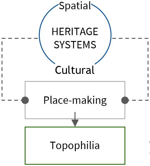
Evoking Topophilia Historicof approachEverydaylandscapesSocio-CulturalArtifactsUrbaninthroughHeritage M, ARCH (URBAN DESIGN) THESIS
Topophilia is a strong sense of place, which often becomes mixed with the sense of cultural identity among certain people and a love of certain aspects of such a place. -Ti Fu Yuan
Area
CriteriaConcernfor chosing Topic
Integrating historic and contemporary everyday patterns of cultural precincts through evoking a sense of belonging in locals for an ensured continuum of spatial and socio-cultural systems. - Develop an urban design framework for cultural precincts of Indian cities - Decoding spatial systems (ecological, physical) of past and present and their transitions to generate resilient built fabric - Understanding the cultural systems of associations and their evolution with time to derive contemporary people-people and people-place dialogues - Evoking Topophilia through spatial and cultural integrations - Develop an urban design toolkit elaborating aspects to be considered for integrating patterns in cultural precinct through sensitive urban design solutions Everyday Heritage can be an approach to place-making process within contemporary landscapes. This would help in establishing the sense of time and place within a precinct evoking Topophilia in the locals.
Urban artifacts are primary elements because their existence has contributed to the morphological and cultural evolution of the city like monuments. It is capable of accelerating process of urbanization in a city.
An everyday heritage approach recognizes the local contemporary spatial, temporal and social rhythms and patterns based on the values, needs and interests of the society within the complex layers of urban landscape.
Statement of Intent ObjectiveAim
India has a rich cultural and historical heritage with a significant part of it lying untapped leading to loss of heritage systems. The preservation philosophy of Indian heritage management is resulting in the isolation of built monuments and landscapes losing the ability to react to contemporary everyday life changes. Though the buffer approach by ASI aims to protect the integrity of the monument by restricting alterations in the built fabric, it fails on local levels leading to halting urban developments and a lack of strengthened urban interfaces. of


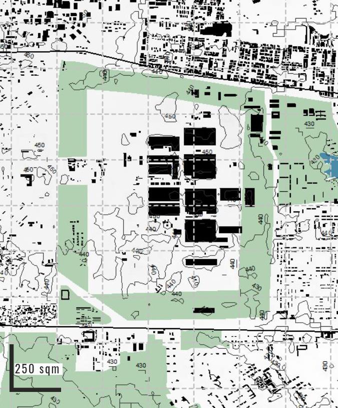
Coarse grain, even texture with monument landlocked in core residential area leading to low accessibility to monuments.
6 5 1 4 32
Sarojini GulmoharGargiSiriIITenclavePanchasheelHauzShahpurjatAsiadRKenclaveSafdarjungnagarPuramvillagekhasDelhifortcollegepark
Inner ring road
INSTITUTIONAL (Siri fort sports complex-Gargi Coarsecollege)grain, uneven texture with institutions abutting historic Siri fort wall. Greens surrounding the institutional buildings. RESIDENTIAL (Asiad village) Coarse grain, even texture with built purely residential in nature. Hierarchy of open spaces and access to greens. MIXED (Shahpurjat) Fine grain, even texture built with mixed use and core residential. Does not have access to open spaces. COMMERCIAL (Hauz khas) Fine grain, even texture with commercial used towards the main road. RECREATIONAL (Gulmohar park) Coarse grain, uneven texture with large open greens used on neighbourhood levels.
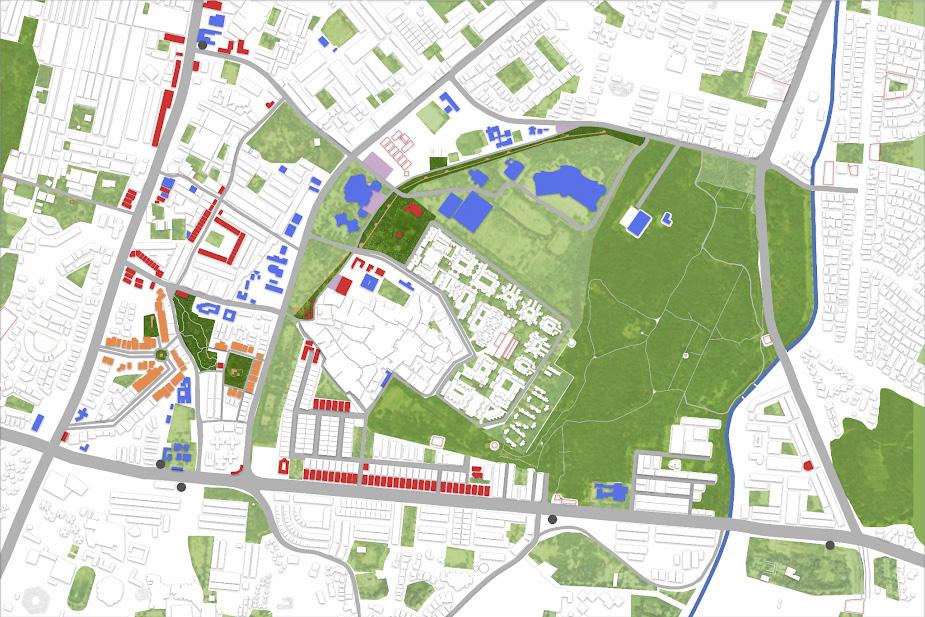
Located in South Delhi, the precinct is surrounded by city, district and neighbourhood level go-to places. Enclosed between major north-south and east-west linkages of the city like Sri Aurobindo marg, Khelgaon road, Josip Bros Tito marg and Outer ring road, it is well connected with the city. It consists of high end residential neighbourhoods like Safdarjung enclave to Urban villages like Hauz khas and TheHumayunpur.siteholds prominent due to it being the 3rd capital city of Delhi. The remains of Siri fort can still be seen in few parts of the precinct along with monuments of Khilji, Lodi, Tughlaq Todayperiods.the precinct is famous for the low real estate prices, affordability and commercialcultural attractions.
LocationMorphologyIntroduction
HISTORICAL (Chor minar hauz khas)


comprises forest land with 70 ha on the west and 50 ha on the east. Some peripheral parks have been developed by DDA. The site is characterized by a major drain (Nallah), fve ASI monuments and the Siri Fort Sports Complex.
Jahanpanah is 175 ha of notifed forest land in the heart of South Delhi. The forest has nine entries at present and is under severe threat of encroachment from surrounding Tughlaqabadcolonies.andAdilabad
South Delhi “Greens” primarily comprise of forests at Jahanpanah, Panchsheel and PanchsheelTughlaqabad.Forest
GreenEcologyblue network 2km
Effective integration of Hauz khas, panchsheel forest and other neighbourhood greens to be done.
forts are protected ASI monuments. They contain large parcels of green forest and protected Ridge area. Some parts of this green cover are proposed as archaeological parks as per MPD 2021. The Satpula nallah flows from satpula from south to north towards Barapullah nallah which flows into Yamuna.


interactions/ dialogues -
Everyday Approach Introduction Bagh i gumbadAlamGumtiKali Dadi gumbadPotiChotiGumtiIdgahChorminar fortSiri gumbadTuhfewala Hauz khas fort Hauz i alai waliMuhammadimasjid Makhdum sahib tomb andsaraiYusufmosqueShahpurjatvillageHumayunpur villagekhasHauznagarArjun saraiSheikh saraiJia villageBegumpur hChiragDelhi Nili masjid Moth masjidki High to low elevationLodiperiod enclavePadmini enclaveHauzcolonyPolicekhasMayfairgarden tShahpurja villageAsiad enclaveGulmohar enclavePanchsheel enclavePanchsheel Monument Mapping Mapping of colonies and Permeability
-
maintenance. Everyday places Everyday routes Everyday activities 500m 500m 500m
increase efficiency
- The neighbourhood exists as islands in the city. Integration is essential to increase the efficiency of its functioning. There is a need for the interfaces to be strengthened to of Visual aspect needs to be enhanced as the potential landmarks are often lost due to lack of


Landlocked between institutional buildings, residential and cultural areas, the Siri fort wall is a linear stretch disconnected from transportation corridors making it a forgotten part of built fabric. Enclosed in the residential urban parcel, the monument chor minar serves as a focal point around a roundabout with low intensity recreational activities in the evening. Centrally placed between the residential enclaves, the tomb and mosque of Makhdum sahib has large greens surrounding it due to buffer approach with is mono functional in nature today making it a private
NodeMetroAutoBusTertiarySecondaryPrimarymonument.roadsroadsroadsstopstand Everyday Places CentralFocalLinear CentralFocal Central 500m
Ecology Map showing vehicular and pedestrian movement patterns. Pedestrian paths are not well strengthened and well integrated with t he monuments roadsPrimary Secondary roads roadsPrimary Secondary roads Tertiary roads roadsPrimary Secondary roads Tertiary roads stopBus Auto roadsPrimary Secondary roads Tertiary roads stopBus Auto stand Metro roadsPrimary Secondary roads Tertiary roads stopBus Auto stand Metro Node roadsPrimary Secondary roads Tertiary roads stopBus Auto stand Metro Node roadsPrimary Secondary roads Tertiary roads stopBus Auto stand Metro Node
Proposed Structure Plan


HighlightsInferences
Urban planning norms
- Post amendment in 2010 - no construction even if the purpose is related to public works - Heritage bye-laws to be formulated after undertaking detailed documentation of the protected area, prohibited area and regulated area in each case - 12.01 Local communities role mainly seen in living monuments - 14.02 Intervention should not reduce significance of monument - Repairs and maintenance to be carried out by owners of heritage 6.2.6buildingsHeritage TDR - Owners compensated for loss of development right incentive FAR 20 for preservation and upkeep - retaining its original character - Total FAR(unutilised and incentive) - TDR in TDR receiving areas
Site GapsGuidelinesapplicabilityandRecommendations
- The associational value is merely restricted to visual as they are not a part if everyday activities leading to loss of opportunities and belongingness in the local fabric.
- Lack of awareness for policy - Lack of holistic conservation plan, works being carried out on an adhoc basis - Updated conservation manual, SOR - Lack of multidisciplinary approach - ASI only mentions inspection note per monument per year which isn't sufficient - No dialogue between ASI and state Archaeology department - No guidelines for unprotected heritage or modern heritage - Over 40% of the area which has scope for development are regulated even though the monuments are not a part of everyday life of the -precinctTheareas under TOD has very less scope of development due to their proximity to heritage monuments protected by ASI - Monument Regulated Zone (As per ASI guidelines Development in Monument Regulated Zones shall be allowed under TOD Policy, subject to compliance of NMA’s restrictions, if any. If part of any scheme contains a Monument Regulated Zone, the benefit of the FAR can be taken within areas outside the regulatory boundaries within the scheme). - As directed by CBCB, 2015 50-100m buffer to be left around city natural drains - 100m - prohibited zone (no building activity/ construction) - 200m - regulated zone (building, repair, restoration activity allowed post permission of National Monuments authority)


Structure plan Existing Structure Plan
ImportantcommerceActivated nodes Existing auto
CulturalTransformationalMonumentsIncreaseExistingstrengthenconnectivityParatransitParatransitNodesnodesMetrolegibilitytobeactivatedguidelinesprecinctsMultilevelcarparkingActivatedcommercial(existing)ImportantnodesExistingautostandsExistingmonumentsandtheirMetrostationCulturalFragmentedinterfaceUrbanparcelsMovementcorridors
ActivatedMovementUrbanFragmentedCulturalstationinterfaceparcelscorridorscommercial (existing) Important nodes Existing auto stands Existing monuments and their precincts Metro MovementUrbanFragmentedCulturalstationinterfaceparcelscorridors
Proposed Structure Plan
Activated commercial (existing) Important nodes Existing auto stands Existing monuments and their precincts Metro
CulturalIncreaseExistingstrengthenconnectivityParatransitParatransitActivatingactivatedMonumentsguidelinesTransformationalcorridorMovementUrbaninterfaceFragmentedCulturalMetromonumentsExistingstandstationparcelstobenodesnodesmetrolegibilityprecincts
ActivatedMovementUrbanFragmentedCulturalstationinterfaceparcelscorridorscommercial (existing) Important nodes Existing auto stands Existing monuments and their precincts Metro
Activating

Strategy 1: Incorporating the DUAC proposal for Delhi greenways and extending it to Hauz khas and neighbourhood level greens like gulmohar park, etc
Strategy 5: Introducing setbacks to the newer built based on careful calculation of visibility of monument to eye level.
Strategy 4: Increasing legibility of monuments along everyday routes of mobility by making ground floor permeable, done by giving incentives to private owners for land pooling and amalgamation.
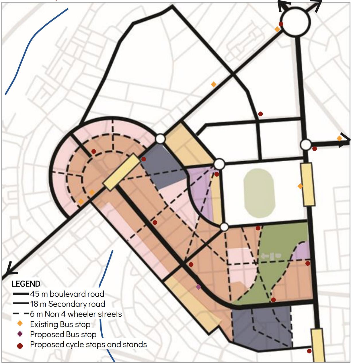
Monuments to be activated Nodes Bus stops Paratransit connectivity strengthen Metro guidelinesTransformational KHASHAUZ
Recovering lost ecological systems of larger city level greens and blues by creating ecological corridors Reinstating linkages and creating new linkages that will improve legibility and access to monuments1 2
Objectives and Strategies
Strategy 2: Introducing water filtration systems along satpullah nullah and creating permeable access to the nullah illustrative proposal for redevelopment of Satpullah nullah edge incorporating visual and physical accessibility and regenerative ecology Increased legibility through stlilt housing and calculation of viewing angle between monument and newer constructions
Strategy 3: Linking Khelgaon marg to Siri fort road along sort fort wall by making it low intensity traffic corridor with predominant pedestrian activities like night bazaars, temporary kiosks, eateries etc.


Strategy 8: Creating permeable boundaries between protected monument and surrounding development.
Strategy 9: Propose transformational guidelines for existing developments for them to be sympathetic to the monument.
Strategy 6: Activating ground floors by introducing public use to them done be giving increased FAR like incentives to private owners.
Strategy 10: Integrating isolated monuments with everyday networks of linkages, activities. Eg: reclaiming Tuhfewala gumbad precinct for community activities like kushti, congregations etc.
Pedestrian network to be strengthened Monuments to be activatedCultural areas to be activated Monuments to be activated Nodes Bus stops Paratransit connectivity strengthen Metro guidelinesTransformational Repurposing heritage monuments by inducing activities in and around the monuments Redeveloping interfaces between heritage monuments and newer developments to create seams3 4
Increased visual connectivity and access by designing permeable boundaries Increased access to monuments making it an integral part of the urban environment with transformational guidelines for integration of built
Strategy 7: Repurposing ASI buffer greens around monuments by inducing plug-ins for temporal activities that cater to everyday and occasional needs of local stakeholders like book fairs, vocational training, cultural activities, happy streets, yoga/ zumba classes, etc that are sympathetic to the monument.


Defining line
of serial vision
Mixed use built Path wayCarriage Central greens wayCarriage Path Design Demonstration 1 Chor minar and Idgah are attempted to be integrated with the existing core residential by breaking the otherwise fragmented urban parcels. The new heritage route aims to connect various neighbourhoods which is activated by creation of multiple to and through points. Activated neighbourhood with plugin junctionNMT Activated greens forPlazas spillover IDGAH CHORMINAR junctionNMT Defining line of serial vision


plugin activities promoting activities around monuments increasing sense of familiarity

The greens around the monuments which were monofunctional before are envisioned to be vibrant and places for cultural associations and congregation of people from various neighborhoods. Defining line of serial vision
Design Demonstration 2
Defining line of serial vision
Path onResidentialstilt wayCarriage Makhdum sahib tomb wayCarriage Commercial junctionNMT JunctionNMT andentrance plaza junctionNMT Reclaimed Shahpurjat bygreens community Seasonal activities promoting culture


culture and helping the local economy to thrive
Placemaking
03
A designed space greatly influences one’s behaviour and it’s important to curate this experience not only for the man but for all that’s living. The art of placemaking can be explored in various spheres of the functioning of city that influence the everydayness of a place.
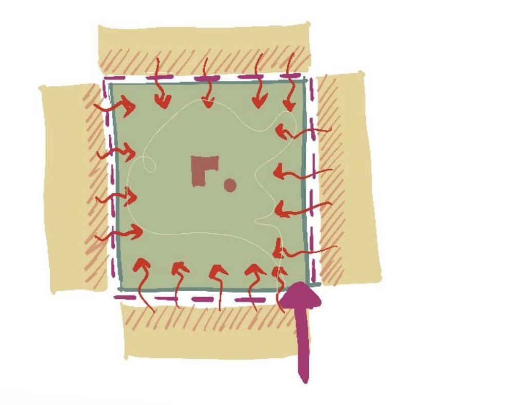
Reimagining the infrastructural void generated due to the flyover along Gol bazar road which is currently occupied by informal vendors. This is achieved by increasing the pedestrianized area along the road and restricting the motorized vehicles to only 2-wheelers with 3m as ROW. The street changes character as per occasions with formalized spaces for street vendors, places for exhibitions/melas or other cultural processions.
Existing Proposed Infrastructural Void SAMBALPUR, ORRISSA Laxmi talkiesLaxmi talkies chowk


MONEY E
M P
What is your idea of self actualization?
N I
V i e w s o f E l
Humare waqt mei humne bohot takleefein sahi thi. Aaj humare bacche khush hai, settled hai. Isse zyada kya hi chahiye. Bus ab maut sukoon se ajae aur zyada takleef na ho. d r l y
What are the social issues you face being part of the elderly group in community? How do you wish to cope? Isolation post covid leading to mental issues. Inaccessibility to spaces or interactions.
Betein Australia mei hain.. Mai aur mere pati akele rehte hai. Baat kabhi kabar hoti hai beton se. Potiyon aur poton ki yaad aati hai. Today I am content and my children have had a good upbringing. I feel I have a purpose in life to motivate others. I continue to do so on voice and video calls today. I ensure I talk to people everyday my family and friends and feel good.
M STATUS A palace for memories where seniors can share experiences and store them, also promoting intergenerational interactions through sessions of storytelling, creative activities, many more... Pensieve INTERGENERATIONAL SPACE | FORM LABS FOR THE ELDERLY Introduction Workflow Design ideation CreativeSportsartsSpecializedknowledgetransmissionKnowledgeandinteractions developmentPersonalityLinguistics Elderly amountVast experienceofandwisdom Shared with the world Shared with the Family [Generations after their lifetime] Personal Family Memories RECORDSPEAKWRITE Stored for generationsfuture Shared with the World as regular short lessons READ HEAR Acrossboundariesglobal
What do you think of intergenerational spaces? Would it help elderly feel good on day-to-day basis?
CHILDREN WIDOWED MOTIVATION C
Ghar par rehne ki aadat hogyi hai. Nahi pata agar jae ya nahi. Lekin haan dudhwale se aur dhobi se baat hojati hai. Shyd aise hi samajhne wale mil jae wahan. I feel it is essential for a person who is already content in his life to be an active part of such spaces so as to motivate others. Yes I feel it could help people to a great extent. Worked as a scribe post retirement in LV Prasad eye institute for the blind. I realised I have a greater goal in life. I continue to do so even at 72 years. I dont understand the idea. I dont know how I would do it. I am happy with what I have. M O R I S O A O S H I P O
Do you feel as if you have already attained it? If not, do you wish to attain it then how?
E
e
W I S D
N

Design SpheresCoordinatedconceptspacesofsynergy Sphere of sensory synergy Sphere of bodily synergy


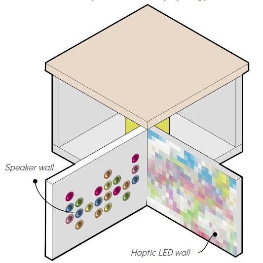

A timeless pensieve encouraging the A dialogue with time...


the elderly to be timeless themselves...


04 Research Epitomizing the bond of urban planning with humanistic concerns and the liberal arts is urban design. The physical urban terrain across cities continually evolves through insights from built experience and consultations with the inhabitants. Research being the foundation, it is essential to understand parameters influencing spaces to help extrapolate the future of places.
Urban village study MOHAMMADPUR, DELHI FigureIntroductionground map Built use map Present in south-west part of Delhi, Mohammadpur village is an Urban village set up in the 17th Century. The precinct includes the Africa avenue (a major transit route), Church road, Safadarjung enclave, Bhikaji cama place and Hauz Khas. A E D C B 50m 50m 50m


TransportationSamplingMorphologycomparitiveandInfrastructure LANDUSE SAMPLE A SAMPLE B SAMPLE C SAMPLE D SAMPLE E GROUNDFIGURE No mixed use Coarse grain Even texture G+2 buildings Religious EvenCoarseInstitutionalandbuildingsgraintextureG+1,+2buildings Park infront of histortical building Coarse grain Even texture G+3 buildings Mixed commercialused, and G+2,+3,+4UnevenFineresidentialgraintexturebuildings Residential only Fine G+2,Unevengraintexture+3,+4buildingsHEIGHTBUILDING BUILDING TYPE: Attached BUILDING USE: Residential BUILDING HEIGHT: G+1 FORM: Regular with central court FRONTAGE:yard Inactive AREA: LOCATION:95sqmNear purana kuan BUILDING TYPE: Semi- Attached BUILDING USE: Residential BUILDING HEIGHT: G+2 FORM: Regular with boundary FRONTAGE:wall Inactive AREA: LOCATION:250sqmSafdarjung B2 BUILDING TYPE: Attached BUILDING USE: Mixed use BUILDING HEIGHT: G+4 FORM: villageLOCATION:AREA:FRONTAGE:IrregularActive80sqmMohammadpur BUILDING TYPE: BUILDINGAttached USE: Res BUILDINGidential HEIGHT: FORM:G+4 Irregular with stairwell in madpurLOCATION:AREA:FRONTAGE:frontInactive40sqmMohamvillage


- High commerce on the main street is leading to isolated interiors.
Spatial configuration
- Few open spaces, and lack of proper infrastructure in parks for kids to play is forcing them to cross Africa avenue for other playgrounds rasing child safety concerns.
- Small Chopal for community gatherings and conducting functions/festivals.
-With predominant Jaat community(residents) and over 50% of tenants, the community is close knit and lives in harmony. -Hindu festivals are mostly celebrated. -Since most of the income is through rentals and shops in the village, the character/activity remains similar throughout the week (including -Childrenweekends).and adults go to Safdarjung park and Hauz Khas park for recreation. Chopal is used by RWA member for everyday gatherings. -Although Gumbad is present in the village, people do not associate with it. It is only a landmark.
Functional structure
Society and Culture Inferences
- Leather market with few existing manufacturing units can be seen as a potential for growth of village and its identity.
- Less activities on service road raises safety concerns during late evenings.


People of the village are mostly dependant on informal markets and rent for their monthly income and the street markets involve encroachment of streets causing congestion. Unorganised parking is also a contributor. People of the village are mostly dependant on informal markets and rent for their monthly income and the street markets involve encroachment of streets causing congestion. Unorganised parking is also a contributor.
01 Lack of visual porosity 02 Congested streets 03 Lack of open spaces
With Teen Bhurji, a historic monument, which remains unknown for even a lot of residents, and Mohammadpur village is struggling for an Identity in the present as it did in the past. With a dense foliage of trees shadowing the built behind, Mohammadpur village and Safdarjung enclave go unnoticed when approached from a car except for the friends colony market and the foot over bridge.
Analysis


Localising SDGs
Delhi aspires to be an inclusive, equitable, livable global city, providing equal economic, social and legal opportunity to all its residents along with access to healthy livelihood, safe, just and pollution-free environment, barrier-free mobility and empowerment in a time-bound manner.
Delhi aims at achieving 15 out of 17 goals with focus on 264 identified indicators for monitoring of SDGs targets. Understanding the extent of localisation of SDG through the defined indicators has been used for analysis. The indicators of Ratio of female to male average wage/salary earnings received among regular wage/salaried employees, Proportion of women in managerial positions including women in board of directors, in listed companies (per 1,000 persons), Operational land holding gender wise (percentage of female operated operational holdings) have not been shown due to lack of access to data/ documentation of related data.
SDG 5 - GENDER EQUALITY | CHALLENGES AND OPPORTUNITIES CompartiveIntroductionanalysis (SDG)- Delhi vs Himachal Pradesh STATE / UT LEVEL WARD LEVEL


1. Sex ratio at birth of the UT of Delhi is less than that at district level but there is a steep decline in the sex ratio at the ward level 9 of NDMC.
4. Only 69.5% of currently married women aged 15-49 years who have their demand for modern methods of family planning are satisfied. The same data is unavailable on district and ward level.
DISTRICT COMPARITIVELEVEL
2. Due to lack of available crime data at ward level we see the comparison of only state and district where the crime rates are more or less the 3.same.The male to female labour force participation rate is less on ward level i.e. 0.18 when compared to state and UT which are 0.25 and 0.26 respectively. The target shows the value should be 1 so it implies that the state is lagging behind in the access to female labour force for participation.
5. As per the table we see that there are a lot of loopholes in the localisation especially after the state/UT level where due to lack of data unavailability the process is being hampered.
In the case of Ward 9 NDMC Delhi, the inferences on the basis of comparison across scales brings out the shortfalls of the localisation mainly due to lack of availability of data.
Inferences


identities DECODING JOURNEY OF BHOPAL
Shifting

The foremost thing that these instances provide are the basic underlying ecological framework which forms the backbone of any city. These turning points in the past are crucial to Bhopal’s form. They have shaped the city’s skeleton. A majority of the aspects in Bhopal’s formation have been dependent or impacted by its ecology. From the laying out of roads, extensively during the rule of the Begums to the growing of commercial zones, from the densification pattern in the city to the technological interventions under smart city development, everything has been secondary to the formation of the framework of Bhopal. The initial foundation of Bhopal was laid through water bodies which helped the microclimate of the city to flourish. Pre-Independence, under the rule of Nawabs and Begums, this foundation was respected and development was in-line with the topography and natural drainage systems of the city. Even though Bhopal being declared as the capital city of Madhya Pradesh post independence brought in influx of population, developments and industries but the Gas tragedy in 1984 increased ecological consciousness and the sensitivity shown towards development through various acts and policies. The initiation of Bhoj wetland project under RAMSAR convention and the two lakes declared as ‘lakes of national importance’ took the ecology of Bhopal to newer heights. This followed with the Swachh Bharat mission, put Bhopal on the National map as the clean and green city in India. All identities of Bhopal were directly/ indirectly linked with its rich ecology as seen. It is post 2015 that Bhopal is negatively developing in terms of ecology. The harm to the environment which has been caused due to cutting of 40000 trees is a serious concern whose effects would not be known immediately but with time. It is true that Bhopal is paving its way to its destruction as today most of the new Bhopalis do not associate themselves with the lakes. Many lakes and baghs are vanishing with time. If this continues, will we still be able to call Bhopal ‘the city of lakes’?
The geography of a city is an integral part of its identity. Three different aspects of geography impact a city: topography, climate, and space. The city form and growth are wielded by the topography - preexisting natural setting of a place consisting of the terrain, contours, slopes, and surface features of a region. The advantages of the unique topography of a city can be maximized by developing around the terrain and using it to create new complementary geographical forms. Bhopal is witness to the creation of a unique system of lakes of varying sizes formed by an inventive use of topography to one’s advantage.
Bhojpal - City of Raja Bhoj City of Begums - Muslim state Capital city - Employment centre Soorma Bhopal Gas Tragedy City of Lakes Smart cityMost liveable city - CleanCitycityof students
IMPACT OF DIGITAL ON SPATIAL PLANNING
people and places so as to celebrate the advantages
the
identify
ImpactBackgroundofDigital revolution
without
digitalAcculturingculture
Industrial revolutions lead to mass production, haste building of factories, cities realizing the adverse effects of industrialization that we see today. The Digital revolution has boomed in India only 6-7 years back and the negative consequences of the same have not been effectively calculated leading to a threat to future cities and their cultural systems. There is a need to the projected future impacts on of Digital revolution.
Communication Trade and Services Physical interactions and associations of people within places B2C DirectANALOG AGE DIGITAL AGE Use of video calls for interactions + One click solutions for medicines, groceries, clothing andOnlinemoreorders, reduced need to go out + Lingering in public space due to social media updates Identification documentsMultiple for identity verification + Unique moreavailingAadharidentityservicesefficiently Transportation Physical travel/ Public leadingVirtualtransportmobilitytoPhysicalimmobility+VR,AR,Metaverse Surveillance Closed community, Patrolling, eye on street + CCTVs, GPS tracking, etc maybe leading to changes of uses and behaviours of inhabitants, citizens, or simple onlookers YEARS6 Thus, Singapore is inaugurating an urban toll system by satellite in 2020, which allows any vehicle to be tracked at any time of the day and to impose dynamic pricing on its use of the road and its access to different types or zones of urban spaces 1990s Telecommunication revolution 2000s Digital revolution (Western countries) 2010s Digital revolution (Indian subcontinent) resulting in concepts of smart city, intelligent city, etc as methods of urban digitalisation dynamics 2015 The data revolution Jio Jio is credited for revolutionising the Indian telecom space for offering high speed internet at competitive pricing 2016 Demonetisation lead to increase in use of online transactions 2020 COVID 19 Work from home, Online education, online services and many more 2015 Digital India improve online infrastructure and increase internet accessibility among citizens Response of people on removing restrictions and curbs of COVID 19!!! Disassociation of people with public space. Comfortable at home Response of people on removing restrictions and curbs of COVID 19!!! Disassociation of people with public space. Comfortable at home.


Conclusion CHALLENGES - Increased urban population - Increased e-waste - Increased pollution, congestion, shortage of housing - Immobilization of people due to technology - Nightlife - safety - Increase in vehicular mobility - Increase in unsafe road infrastructure
PARAMETERS OF FUTURE CITIES - Hyperconnected urban ecosystems that respond to your data - Self-charging green cities - The economy needs to be regenerative by design, modular and open -sourceSmart decision making - data driven decisions - Self healing & Smart Infrastructure - Self powering cities - Fluidity, Impermanence - Cyber security - Economic, spatial and environmental regeneration
Role of designer in the future techno driven city Without people, the places would be empty Striking balance is essential to ensure cities aren't lead to doom InstitutionalCommercial Schools and RestaurantsReligiousOfficecollegesspaces Before After Spatial manifestations Warehouses Spaces No designated space req No designated space req No designated space req Cloud kitchens MOHE Infrastructural voidsInfrastructure Malls AmphitheatreOfficePhysicalstreetsshoppingandspaces,ReligiousDineinindividualrestaurants Virtual shopping Virtual teaching, co learning and cloudOnlineReligioushomeWorkdiscussionsfromdeliverykitchens Road ways with trafficheavy trafficwithinfrastructureRoadminimal Spatial comparitive (Pre and post digital revolution) Projected changes in spatial planning


05 Local planningarea A designed space greatly influences one’s behaviour and it’s important to curate this experience not only for the man but for all that’s living. The art of placemaking can be explored in various spheres of the functioning of city that influence the everydayness of a place.
Stakeholder identification Introduction RESIDENTS (DOERA) PROVIDERSSERVICE VISITORS PROVIDERSDOMESTICOFFICERSHELPERSSERVICE CHILDRENFEMALEMALE TRANSIT PURPOSEONFORMAL INFORMAL OUTSIDE LOCALITY RecreationVegetable & TeavendorsFruitsellerAmulGroceryshopshopSafalstoreSBIBank SLUM RECRUITED AUTHORITIES DIRECTORATEDEFENCEESTATESMESDEORANDMC Local area planning PARTICIPATORY DESIGN AND ACTION PLAN 200m 200m
Located in the posh area of Chanakyapuri, the locality lies S-E of the central ridge.
District: Central Delhi | Ward no.: 09
Situated to the south-east side to the central ridge, surrounded by sensitive ecological networks like buddha jayanti park, rail eco park. Dense vegetation and numerous neighbourhood and district level greens.
The locality comprises of areas between SP marg, Panchsheel marg and San martin marg on another side in a radius of 500m from junction.


Complex run under Battle honors mess. The complex has been rented to eateries like CCD, Toffee Bar etc with Army thrift shop , parlour, etc. Amidst the lush greenery and seating provisions, it acts more as a city level destination for hangout and leisure than a neighbourhood cafe due to high prices. This leads to congestion on road due to on street parking esp on weekend. A popular destination for youth.
Streets in the locality have predominant 4 types of uses. They are uniform in nature with tree lining on either side and high boundary walls of the embassies or the government Duecolonies.tolack of open spaces/void activities take place on streets. No segregation of economic groups can be seen on streets.
Opposite to Taj palace hotel lies the AWWA (Army Wives Welfare Association)
Opaque Partially porous PorousEDGE TYPE 10m Alternatingbalconies Voids in between the built Recreational amenities Building Void Road Officers park 5m5m Tarp + trees as shading Recreational amenitiesFootpathRoad BufferpathFootBuffer Opaque Partially porous PorousEDGE TYPE 10m pathFootRoad BufferpathFootBuffer AWWA Complex Seating + trees + cafes
DOERA is the residential campus for Army, Air force and Navy officers with 271 families residing. Attached are quarters for domestic helpers. The residential colony has 25 blocks of 5 storey towers with large green spaces, few planned and many unplanned greens. It has a shopping complex which is not very active. Children of the officers have access to amenities and playgrounds but domestic helpers children play on road which conflict with car routes.
Locality


No. of flats - 271 (25 blocks)
Characterised by high ROW, lush green vegetation, 5 storey residential towers and garages used for storage and on road parking around the buildings.
No. of Defence personnel families - 240-250 (3-4 persons per HH)
Best things about the campus: Location, Environment and trees, Clubs pre covid - walkers club, pustakshala, akshay patra
IntroductionDEORA 100m
No. of Servant families - 230-240 (4-5 persons per HH) - More of the servants hailed from UP, Bihar, UK and HP 20-30 years back and settled here. Only 3 servants are permitted on ID card basis from Sanjay camp. - Officers are transferred every 2-3 years.
Drawbacks of campus: Very less community interactions No development since 40 years No waste seggregation No alternative means of earning in the campus


Chrice Matrix: highlighted the reasons for failure for previous initiative which were mainly administrative in nature and lack of designer for holistic vision. Bridge model: appreciated good aspects of locality like greenery and location and brought out bad aspects to work on Discussions on model: brought out exact location for interventions though to and fro communications with core -members.Lackofresponse on whatsapp groups. People wait for others to respond and leave it on seen. - Placement of notice boards in the campus - Not very easily seen from -roads.Although people agree on coming during one-on-one interactions they do not turn up. Difference of opinions between tri-services.
Participatory research and design PLA methods


Issue mapping
Small community space for officers only (accomodates 50 ppl max)
Main road with high traffic leading to lack of access to shared amenities
Underutilisedinfrastructure street and surrounding
Walkinggreens trail not maintained properly - people not using the space
Unplanned roads with large tarred areas and no footpath Roads with no tree lining or pedestrian
Inactive shopping centre and no basic needs shops leading to people going faraway places
- Issues are predominantly administrative related due to the complex protocols and procedures for financial grants and execution - The funds allocated are only in the name of Officers development leaving domestic helpers with lack of proper -infrastructureEventhough there is plenty of land, infrastructure like shopping complex, they are not used to full potential due to lack of vision
Largecourt areas with less dense vegetation which have potential for development
Green/ Open spaces between buildings and along boundary walls not used to optimum potential
Large dense greens, undeveloped areas used for garbage dumping
Lack of maintenance of basketball


Proposed structure plan + Strategies
OBJECTIVE 3: Introducing frameworks and design solutions for sustainable living in areas of harvesting rainwater, waste management, solarutilizingenergy, etc - SDG 6, 12
OBJECTIVE 2: To activate the unplanned greens and voids between the buildings by inducing infrastructure and magnet activities that promotes various natures of interactions - SDG 3, 11, 16
Strengthening road infrastructure along main corridors of vehicle and pedestrian movement Making the underutilized road pedestrian friendly to promote newer Continuousdialogues pedestrian trail connecting both sides to ensure access to shared resources Introducing paved surface for slowing traffic speed for pedestrian crossing
Strategy 3: Reclaiming the underutilized spaces between the buildings to enhance public interactions in the society by inducing activities and designing street infrastructure for pausing.
Strategy 6: Propose a sewage treatment plant in both enclaves for reuse of waste water in watering plants.
Strategy 4: Redesign community centre and gym with integrated greens.
Strategy 1: Introducing bioswales/ creating catchments for capturing surface runoff as rainwater harvesting Strategy 2: Create walking tracks alongside natural features with activities for maximum participation of residents.
Strategy 4: Creating a wet segregation system in which wet waste and dry waste is collected separately. Wet garbage is collected and used in local parks and other green spaces, while dry waste is sold to various vendors for recycling.
Strengthening play-infrastructure with access to all children Segregation of waste collected from dry-wet waste bins located in enclave Promoting sustainability through reuse of waste water treated in STP
OBJECTIVE 1: To connect the ecologically sensitive unplanned greens to larger ecological networks - SDG 3, 11
Reclaiming the underutilized space between buildings for kitchen garden and utility areas for domestic helpers
Strategy 5: Redesign drainage system for the campus with surface drains connecting to rainwater collection pit.


soilretentionBio
Harvested potential = 246800 x 0.8 x 0.85 = 167824 litres
As per Rainwater Manual, Rainwater harvesting = Rainfall (mm) x collection coefficient Rainwater endowment = Area of Plot x height of rainfall = 400 x 0.617 = 246800 litres
Rainwater captured on every building has a rainwater outlet but is drained on street. Proposal is to connect the RWP with filter and a tank for storage which pumps water to OHT can be used for washing and flushing purposes.
Rainwater harvesting
Introducing bioswale which captures rainwater from surface runoff which is connected to the treated water tank of STP thereby ensuring water to be used for gardening in the campus.
Considering 4.4 people per household, the rainwater which can be harvested per building is equal to drinking water enough for 173 days for 22 household with 10l water consumed per person per day. networks
RevivingServicesecological


(no. of people) x (avg water demand) x (sewage flow) x (peak factor)
ExistingFRAMEWORK
Proposed Safai karamchari trained by Saahas zero waste Waste segregated at home Dry - sent for secondary sorting Wet - Compost pits maintained by nursery between 2 buildings. Manure used for Kitchen garden and other areas - Ration given to service officers every 2 weeks
Rainwater connected to treated water tank to form a combined system after which the water is pumped for gardening in the society and car wash purposes.
Kitchen garden Output used by domestic helpers for daily use a common consensus by the residents as they get ration and have spaces like balconies
Tie up with Saahas NGO under agency processed - initiative taken under LAP studio framework Sewage treatment Waste management
Total population - 1000 ppl Water demand per person/day - 160L (Avg) Sewage flow - 80% Total capacity of STP=384KLD=1000x160x0.8x3
Waste dumped in location A and collected by gaadi
Station headquarter collects garbage once a Safaiweek Karamchari (total) - 18ppl (6 garbage + 12 cleaners)


BREAKING THE CYCLE Existing cycle Proposed cycle Spot ShoppingDesigncomplex ESSENTIAL SHOPS + Grocery + Vegetable shop + Medical shop + Stationary shop + Chai/Snacks + Amul + Tailor + Dry cleaner + Bakery
Similar to AWWA complex, the shopping complex is made open to public inviting essential shop owners to set their shops catering to the services which locality is devoid of. This would allow in the breaking of cycling which was created over a period of time. The rear space would be used for food trucks and stalls with semicovered seating. A provision for weekly markets on a podium has been given which can be used dynamically during other times.
Aims at providing residents of DEORA basic amenities in closer vicinity through an established framework benefitting the residents, DEORA committee and the vendors. Various activities together form a economic cycle sustaining the requirements of the precinct. The objective is to provide basic amenities at affordable rates so as to benefit all economic groups of residents.


8 Bioswale (SDG 3,11) Sharing... 7 Kitchen garden+Utility+RWH(SDG 6,12) 1 Along the roads (SDG 10,11) 6 Play areas (SDG 11, 16) 5 STP+Greens (SDG 6, 12) 2 Paved street + Play street (SDG 3,11,16) 4 Community and training center (SDG 4,10) 3 Linking the sides (crossing along shopping complex) Walking trail

