3 minute read
Surnames » 12


El Barrio de San Juan
El barrio de San Juan se ubica en las calles 62 y 64, entre los cruzamientos de las calles 67-A y 69-A. En 1700 fue habitaba por una población conformada de mestizos, criollos, pardos e indígenas.
Advertisement
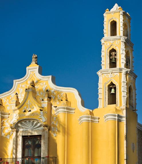
Hasta 1769 comen - zaron los trabajos de construcción de la iglesia con el apoyo del Dr. Agustín Francisco de Echánove, la cual se construyó sobre una capilla del siglo XVII y terminándose de construir el 23 de junio de 1770. Los lugareños le oraban al Patrono San Juan Bautista, clamaban protección de sus cosechas por que anteriormente 3 plagas de langostas habían afectado sus cultivos en 1552, 1616 y 1666, respectivamente. La iglesia se convirtió en el en 1690 para delimitar la ciudad. El arco
centro de devoción con celebraciones y procesiones especiales para orarle y agradecer al Santo Patrono.
El barrio tenía una plaza llena de polvo y un pozo de agua para abastecer a los pobladores de este recurso. El corredor tiene influencia mudéjar, destacándose dentro del conjunto que fue parte de un mesón público para los viajeros que existió detrás del templo, antecediendo a la sacristía y quizás sea la úl1883 se conformó la plaza que también tiene el mismo nombre.
A inicios del siglo XIX, la iglesia cobijaba a los Sanjuanistas quienes eran independistas yucatecos, el grupo tuvo un papel importante en la independencia de la capitanía general de Yucatán de la nación española. En el parque está la emblemática fuente “La negrita” traída de París a principios del siglo XX.
San Juan cuenta con un arco en la calle 64. Al igual que los demás arcos de la ciudad, se edificó aproximadamente tima evidencia de la capilla original. En
de San Juan posee grandes dimensiones, antiguamente la calle donde está el arco era el antiguo camino real a Campeche. En el remate hay un nicho que alberga una pequeña escultura de San Juan Bautista.
SAN JUAN NEIGHBORHOOD
The San Juan Neighborhood, or Colonia, is located at 62nd and 64th streets, between the intersections of 67-A and 69-A streets. In 1700, its inhabitants were primarily mestizos (people of Spanish and Maya parentage), criollos (children of Spaniards born in the New World), pardos (individuals of African and Maya parentage), and Maya people, which is to say, everyone. Dr. Agustín Francisco de Echánove, in 1769, financed the construction of neighborhood.
It was built over a 17th century chapel and was completed on June 23, 1770. The residents prayed to the Patron Saint John the Baptist, asking for the protection of their harvests. In previous years, three locust plagues devastated their crops in 1552, 1616, and 1666. The Church became the center of devotion with celebrations and special processions to pray and give thanks to the Patron Saint.
The neighborhood had a square full of dust and a well so that residents used for water for their daily use. The streets show a Mudejar influence, with an ensemble that was part of a public inn for travelers that existed behind the temple standing out. It was located behind the sacristy and is perhaps the last evidence of the original chapel. In 1883 the square that also bore the same name was constructed.
At the beginning of the 19th century, the church sheltered the Sanjuanistas, Yucatecan Independentists who played had an important role in the independence of Yucatán from Spain. “La Negrita,” the emblematic fountaing improrted from Paris at the beginning of the 20th century is a feature of the park.
San Juan has an arch on 64th Street. Like the other arches in the city, it was built around 1690 to demark the city’s border. The arch of San Juan has large dimensions. Formerly, the street where the arch is was the old Royal Road, or Camino Real, to Campeche. At the top there is a niche that houses a small sculpture of Saint John the Baptist.