Cavendish
Coleraine r
g nel Gle
Digby
Yatchaw
Henty
Grassdale
Y HW A200
Buckleys Swamp
Branxholme
Heywood
12
Ri v er
12
Heathmere
Mount Richmond
A1
Gorae West
Discover y Bay Coastal Park
CES
Mt Richmond National Park Cashmore
Discove ry Bay Marine National Park
Trewalla
Cape Bridgewater
PRIN
CES
Y
Ellerslie Noorat
Yambuk HW
Y
A1
11
Killarney 10
9
Ecklin South
Laang
Allansford Naringal Ayrford
B100
Nullawarre Childers Cove
IPW
RE
Nirranda
Curdie Vale
CO A
T EA
CK
s die Cu r GR
COAST
ST
Peterborough
To report injured native wildlife, please call 03 8400 7300 Port Campbell Glenelg River Canoe www.emergency.vic.gov.au www.cfa.vic.gov.au 7 13 Discovery Walk /Kayak Trail www.parkweb.vic.gov.au www.vicroads.vic.gov.au
To report injured native wildlife, please call 03 8400 7300 Secondary road C151 – sealed Great Ocean Road www.emergency.vic.gov.au www.cfa.vic.gov.au www.parkweb.vic.gov.au www.vicroads.vic.gov.au
EXPLANATION EXPLANATIONOF OFROAD MAP SYMBOLS SYMBOLS VisitorFreeway information M1 Scenic view / lookout Under construction Lighthouse site A1Shipwreck Highway Patrolled beach* Major road B100 Surf lifesaving club*
Winery Secondary road – unsealed Golf course Walking track Minor road Cycling track Vehicular Nationaltrack park Searoad Ferry Walking Trail
*For patrolled dates and timesroad visit: www.beachsafe.org.au Secondary
C151
To help plan– sealed and get the most out of your trip, an Road Greatvisit Ocean accredited Visitor information centre.
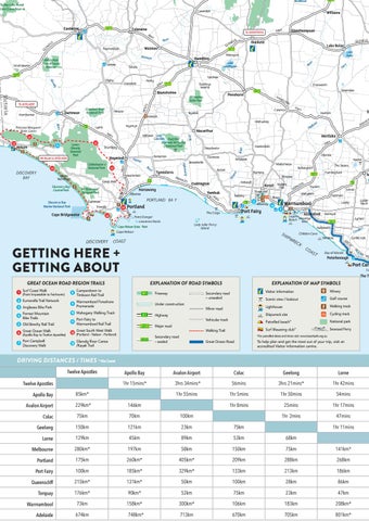
DRIVING DISTANCES / TIMES * Via Coast
Apollo Bay
Apollo Bay
Avalon Airport
Colac
Geelong
Lorne
1hr 15mins*
3hrs 34mins*
56mins
3hrs 21mins*
1hr 42mins
1hr 55mins
1hr 5mins
1hr 50mins
54mins
1hr 8mins
25mins
1hr 17mins
1hr 2mins
47mins
85km* 229km*
146km
Colac
75km
70km
100km
Geelong
150km
121km
23km
75km
Lorne
129km
45km
89km
53km
68km
Melbourne
280km*
197km
58km
150km
75km
141km*
Portland
175km
260km*
405km*
209km
288km
268km
Port Fairy
100km
185km*
329km*
133km
213km
186km
Queenscliff
215km*
131km*
50km
100km
28km
86km
Torquay
176km*
90km*
52km
75km
23km
47km
Warrnambool
73km
158km*
300km*
106km
183km
208km*
Adelaide
674km
748km*
713km
670km
705km
801km*
Avalon Airport
RD
Lo
DRIVING EXPLANATION THE GREAT OF ROAD OCEAN SYMBOLS ROAD
Twelve Apostles
N
The T Travel times are a guide only and may vary due to the scenic Freeway Secondary road M1 nature winding of roads and different weather conditions. – unsealed The region is best enjoyed at a leisurely pace with lots of detours andUnder stops!construction Expect travel times to be longer during peak season. Drive on the left in Australia and useroad slow turn Minor out lanes to allow others to pass. Share the drive – don’t do A1 Highway the Great Ocean Road from Melbourne in one day. Vehicular track Stay safe: Be aware of the environment within which you are road B100 InMajor travelling. an emergency call: 000 (police, fire or ambulance). Trail VicEmergency hotline: 1800 226 226 (free Walking call)
Twelve Apostles
OC
EA
Bay of Islands
Port Cam
GREAT DRIVING OCEAN THE GREAT ROAD REGION OCEAN ROAD TRAILS
(Portland - Nelson - Portland)
Garvoc
Logans Beach Mepunga West
SH
Travel times areWalk a guide only and mayCamperdown vary due to the Surf Coast to scenic 1 8 (Pointnature Impossible to Fairhaven) winding of roads and different Timboon weather conditions. Rail Trail The region is best pace with lots of 2 Eumeralla Trail enjoyed Network at a leisurely Warrnambool detours and stops! Expect travel times to be longerForeshore during 9 Promenade Bike Park 3 Anglesea peak season. Drive on the left in Australia and use slow turn out lanes to allow others to pass. Share the drive – don’t do Mahogany Walking Track 10 Forrest Mountain 4 Great Ocean Road from Melbourne in one day. the Bike Trails Port Fairy to 11 Stay safe: Be aware of the environment within which are Warrnambool Railyou Trail 5 Old Beechy Rail Trail travelling. In an emergency call: 000 (police, fire or ambulance). Great South West Walk Great Ocean Walk 1800 226 226 VicEmergency hotline: 12 (free call) (Apollo Bay to Twelve Apostles)
Te
Panmure
Warrnambool
GETTING HERE + GETTING ABOUT
6
Purnim
Wangoom
Lady Julia Percy Island
Cape Nelson
PK
HO
Framlingham A1
INS
Illowa
Port Fairy
The Crags Point Danger Lawrence Rocks Cape Nelson State Park
Mailors Flat
Tower Hill
Toolong
Portland
B120
Winslow
Koroit
The Sisters
Ballangeich
Warrong Kirkstall
Codrington
Narrawong
HA
HW
Woolsthorpe Oxford
Allestree
LT
MI
ins
Willatook
Bessiebelle
PORTLAND BA Y
12
12
DISCOVERY
pk
Hawkesdale
Rive r
Dunmore
Tyrendarra
D
Hexham
Mortlake
Broadwater
Homerton
Fitzro y
PRIN
DISCOVERY BAY
Y
Macarthur Milltown Lake Condah Budj Bim (formerly Mt Eccles) National Park
Drumborg
Cobboboone e National Park
HW
Ho
yn e
Alt Route to ADELAIDE
N
Minhamite
Y
13
LTO
Caramut
Myamyn HW
Nelson
MI
Byaduk
Condah
Lyons
12
HA
TY
Hotspur
12 Lowe r Glenelg National Park
Penshurst
Mo
A1
Woorndoo
B140
Rive r
Rive r
Princess Margaret Rose Caves
Crawford River Regional Park
Eumeralla
Dartmoor
Mumbannar
Chatsworth
Mt Napier State Park
HEN
ES
HWY
Victoria
P
RIN To ADELAIDE C
Lake Linlithgow
Tahara
B160
Lake Bolac
Warrayure
Hamilton
GLENELG
Lake Bolac
y
Merino
Dunkeld
B160
Wannon
Wilkin Park Flora & Fauna Reser ve
ELG
EN
GL
Wannon
Paschendale
G
Strathdownie
Rive
G
EL
Glenthompson
HWY
To GRAMPIANS
Y
Fie r
B160
HW N LE
Willaura
Ri v er
Casterton
12
B180
Muirhead
Tooloy-Lake Mundi State G ame Reser ve
1hr 11mins