

Acknowledgement of Country

Meerreeng, Parreeyt pa Moorrnong (Land, Water and Sky)
Antarctica Architects acknowledge the Eastern Maar as the traditional custodians of the area. We pay our respects to their Ancestors and Elders, past and present. We recognise and respect their unique cultural heritage, beliefs and intrinsic connection to their traditional lands, which continue to be important to them today.
We value the contribution their caring for Country makes to the land, coastlines, waterways and seascapes within the municipality. We support the need for genuine and lasting partnerships with the Eastern Maar People to understand their culture and connections to Country.

Project Process
This report aims to consolidate; site information, background documents, policy, and guidelines to inform guiding principles and identify opportunities & constraints for each site.
The project process has included weekly meetings & consultation with GORCAPA.
Meetings included presentation and review of site analysis, discussion and review of policy and guidelines, and presentation of concept development.
GORCAPA have released a Community Values Survey which will be used to review of the opportunities and
The design team have conducted design & site analysis workshops and visited site to inspect and document existing conditions.
The project team have consulted with GORCAPA stakeholders, representatives from the Eastern Maar Aboriginal Corporation, stakeholders from the Department of Jobs, Skills, Insustry and Regions, the Community Reference Group and the Technical Working Group.
The following consultants have been engaged during this phase by Antarctica Architects:
Sustainable Project Management (SPM)
Marine & Coastal Act Consultant
Enlocus
Landscape Architects
Spectrum Planning Solutions
Planning Consultant
Intrax
Structural & Civil Engineers
Simpson Kotzman
Services Engineers
ACHM
Cultural & European Heritage Consultants
Steve Watson & Partners
Regulations Consultants

Background Documents
The following documentation has been reviewed and informed the development of the Opportunities & Constraints report:
· Apollo Bay Harbour Development Plan Final, TRACT Consultants, 22.12.20
· Apollo Bay Harbour Development Plan Review & Assessment, Coastal Planning and Blue Sense Consulting, 30.01.2024
· Review of the Apollo Bay Harbour Development Plan Review & Assessment, Sustainable Project Management, 08.12.2023
· Eastern Maar Country Plan, Eastern Maar Aboriginal Corporation, 01.07.2015
· Eastern Maar Nation Statement, Eastern Maar Aboriginal Corporation, 13.07.2024
· Apollo Bay Harbour Redevelopment Design Review, Victorian Design Review Panel, 01.03.22
· Apollo Bay Harbour Redevelopment Planning Advice, Claire Scott Planning, 20.10.23
· Apollo Bay, Skenes Creek & Marengo CIP Issues & Opportunities Paper: Coastal, Water Technology, 23.06.19
· Apollo Bay Harbour, Coastal Hazards Vulnerability Assessment,Water Technology, 11.06.13
· Coastal Hazard Management Plan Skenes Creek to Marengo, Water Technology, 26.10.12
· Geotechnical Desktop Study, Apollo Bay Harbour, YTTRUP, 14.11.19
· Geotechnical Site Investigation Report Apollo Bay Harbour Precinct, Provincial Geotechnical, 24.11.21
· Geotechnical Assessment Report Apollo Bay Harbour, St Quentin, 01.12.21
· Pavement Investigation Report Apollo Bay Harbour, Ground Science. 13.07.21
· Apollo Bay Harbour Precinct Investments Scenarios Assessment, MacroPlan Dimasi, 26.09.18
· Apollo Bay Harbour Redevelopment -Stage 1, Cultural Heritage Management Plan, ACHM, 01.12.21
· Apollo Bay Harbour Redevelopment -Stage 2, Cultural Heritage Management Plan, ACHM, 03.12.21
Project Process
· Apollo Bay Harbour Development Native Vegetation Removal FINAL, Biosis, 06.02.22
· Apollo Bay Harbour Redevelopment: EPBC Act
· Apollo Bay Harbour Redevelopment Stage 1&2, PreTender Estimate Rate Review, Muller Partnership, 19.09.23
· Colac Otway Planning Scheme, (including:) Schedule 2, Clause 37.01 Special Use Zone, Colac Otway Shire, 20.05.21
Key drivers of a changed approach
A number of legislative and policy changes have affected the redevelopment of the Apollo Bay Harbour. The key drivers of our current approach include:
2020
Gazettal of the Marine and Coastal Act (MACA) Gazettal of the Great Ocean Road and Environs Protection Act.
Release of the Marine & Coastal Policy
Publication of revised Siting and Design Guidelines for Structures on the Victorian Coast.
2022
Interpretation and application of the Marine and Coastal Policy in Baker v Surf Coast VCAT 257 at Point Grey, Lorne by the Victorian Civil and Administrative Tribunal.
2023
Eastern Maar Aboriginal Corporation receives formal recognition of Native Title through the Federal Court.
Release of Victoria’s Resilient Coast, Adapting for 2100+ to guide coastal hazard responses.
Geelong City Deal Funding
The project is funded by the Geelong City Deal. This outlines the scope to be met in order to achieve the deliverables required by the funding.
This scope must be prioritised within the project and reviewed against legislative requirements.
scope are listed below:
· Mother’s Beach car park upgrade
· Harbour precinct entry road upgrade
· Provision or upgrade of pedestrian and bicycle paths connecting the harbour precinct with the township including historical and interpretive signage
· Extension of the Fisherman’s Co-op building
· Upgraded Port Operations Depot with public change room and amenities
· Replacement of fencing in the harbour


Region: Marine & Coastal Act 2018
The Marine and Coastal Act 2018 (MACA) provides the framework for coastal planning and management in Victoria.
The Apollo Bay Harbour is located on coastal Crown land and for the redevelopment to proceed, it must receive consent under the MACA. The proposed uses, development and works are required to be consistent with several matters within or established by the MACA.
The relevant matters include:
• The Marine and Coastal Policy (the Policy).
• The Marine and Coastal Strategy (the Strategy).
• Objectives and guiding principles set out in Part 2 of the MACA.
• Any coastal and marine management plan (CMMP) applying to the land.
The Department of Energy, Environment and Climate Action (DEECA) assesses applications for consent which may then be issued by the Minister, or their delegate.
The Marine and Coastal Policy 2020 sets out policies for planning and managing the marine and coastal environment, and to provide guidance to decision makers in achieving the MACA’s objectives. The Policy applies to all private and public land and waters between the outer
of the high water mark of the sea, including bays, inlets, estuaries and the Gippsland Lakes.
The Policy establishes a (the Pathway) that sets out how the objectives and guiding principles of the Act are to be used in decision making for the marine and coastal environment (see p15), which includes the assessment of a consent application for use and development. The Pathway aligns with the chapters of the Policy.
wide range of other legislation and supporting documents that affect the sustainable use of the coastal and marine environment. Several of these include separate permissions which the redevelopment is required to
The Marine and Coastal Strategy 2022 actions to achieve the Policy. A key action is Action 4.6 Implementing the Sustainable Local Ports Framework led by the Department of Transport (now the Department of Transport and Planning). This Framework is available at: https://www.vic.gov.au/about-Victoria’s-local-ports.
Siting and Design Guidelines for Structures on the Victorian Coast 2020 (the Guidelines) were established to assist in the implementation of the Policy. The Guidelines apply to all development on Victoria’s coast, whether on public or private land. They provide a set of fundamental considerations that underpin best practice for future use and development of structures and facilities on the coast.
The GORCAPA Coastal and Marine Management Plan (CMMP) was adopted by GORCAPA in 2021 and brought together CMMP’s from the Great Ocean Road Coast Committee and Otway Coast Committee of Management. The Otway Coast CMMP includes:
• A vision, goals and management outcomes consistent with the Policy
• A range of strategic and precinct actions, several of which relate to the Harbour.
To ensure that consent can be achieved under the MACA, the process to redevelop the Harbour precinct has included a Planning and Assessment Pathway. This includes all relevant matters under MACA and its supporting documents as well as the key decision-making needs within other relevant legislation and policy.

GREAT OCEAN ROAD
TO CAPE OTWAY
TOSKENESCREEK
Local: Apollo Bay
The town of Apollo Bay and the Harbour precinct is located along the Great Ocean Road, between the townships of Skenes Creek to the north and Marengo to the south. Situated 125km from Geelong to the north east and 155km to Warnambool to the north west, the nearest major town is Colac located 70km to the north through the remote Apollo Bay-Forrest Road.
Apollo Bay and the small neighbouring township of Marengo are the southernmost populated towns on mainland Australia, and their geographical location and remote nature has shaped their development.
With a permanent population of 1,800 which expands to around 15,000 during the high tourist season, tourism and the visitor economy plays a vital role in economic development of Apollo Bay.
The Great Ocean Road with national parks, world renowned surf and ocean beaches as well as spectacular scenery has long been a tourist destination. Surrounded by natural beauty including the backdrop of the Otways National Park, the town is a large tourist attraction on the Great Ocean Road and an important feature of the region.
The landscape values of the Apollo Bay area are
Region Landscape Assessment Study undertaken in 2003, it was determined that the ‘Apollo Bay Coastal Valleys visually dramatic intersection of landscape elements. Landscape Assessment Study in 2006.
APOLLO BAY HARBOUR PRECINCT
MOUNTS BAY
MARENGO
APOLLO BAY
APOLLO BAY TOWNSHIP
Local: Use & Movement
Apollo Bay Harbour
Harbour entrance where vessels arrive and depart from within the harbour.
Mothers Beach
Pedestrian ramp at the entry to mothers beach from the inner breakwater.
Mother’s Beach carpark
Public parking at end of Breakwater Road, the adjacent boom gate secures entrance to the harbour.
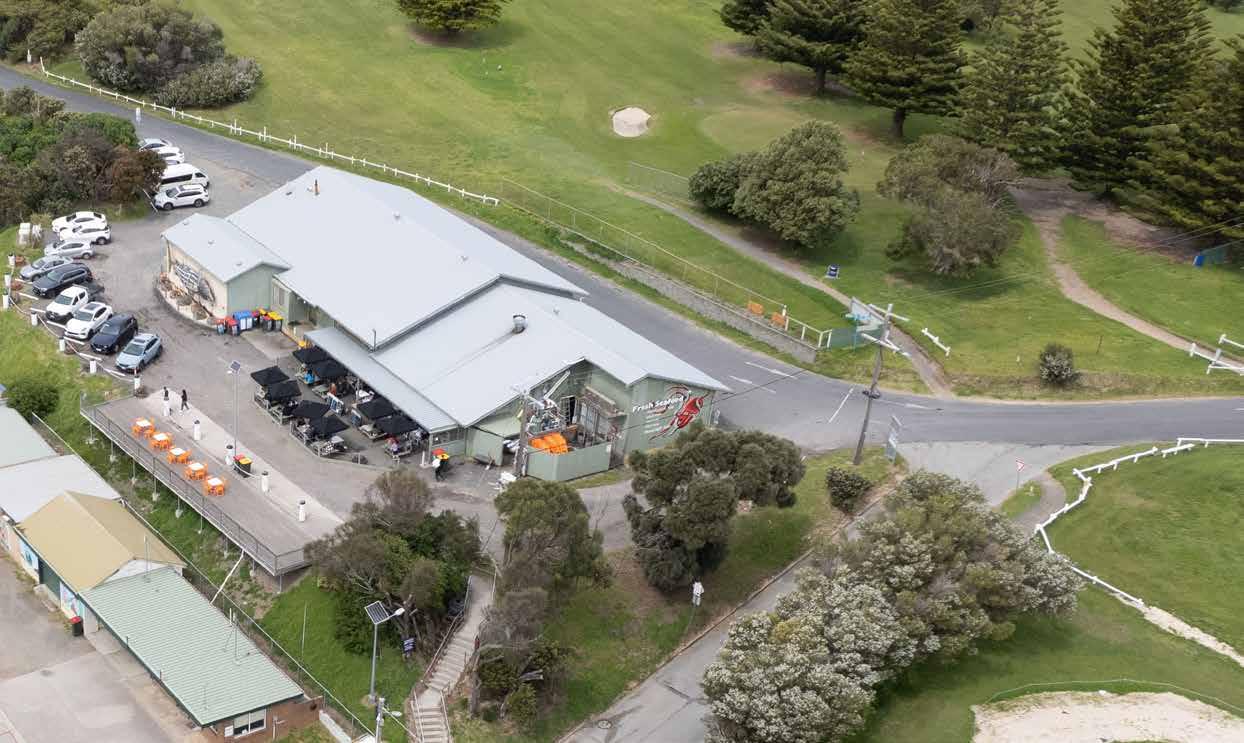
The Apollo Bay Fisherman’s Co-Op
Vehicles can currently drive around the whole building and park facing the harbour. There are multiple delivery points around building for vehicles.
Public boat ramp
A vehicle ramp and trailerable boat entrance to the harbour including trailer parking.
Breakwater Road
A shared pedestrian and vehicle road.
Nelson Street
The road connecting vehicles to the harbour from the Great Ocean Road.
Great Ocean Road
The main road into town from both sides of the coastline and the larger centres of Colac, Geelong and Melbourne.
Vehicle movement
Pedestrian route
Primary Vessel route
Local: Flora & Fauna


Apollo Bay is located in the Otway Ranges terrestrial bioregion and at the eastern edge of the Otway Marine bioregion. Its location in the lee of Cape Otway provides a degree of shelter from the rough seas and winds often experienced further west. As a result, the Harbour precinct experiences a diverse range of terrestrial and marine species.
Bay Harbour Precinct was undertaken by Biosis in 2022. While the site contains a considerable amount of nonindigenous vegetation, the assessment found:
• 2.248ha of native vegetation comprising Coastal Dune Scrub EVC 160 and Coastal Dune Grassland EVC 879. This has been mapped onto the Harbour precinct site plan to demonstrate where particular areas of vegetation are present.
• the development footprint.
• Two threatened species listed under the Victorian Flora and Fauna Guarantee Act
• Native vegetation that may provide habitat for one bat species. It also noted that due to the proximity of the ocean and the Barham River estuary the site may be used a wildlife corridor for shorebird species.
•
noted the proximity of the open coast salt-wedge community in the Barham River Estuary which is listed in the federal Environment Protection and Biodiversity Conservation Act.
• No Ramsar sites within 5km.
migratory species have been recorded or are predicted to occur in the area.
While the new precinct design will endeavour to avoid removal of indigenous vegetation and retain building positions and scale, further assessment of ecological
Coastal Dune Scrub EVC 160
Non-Indigenous Vegetation
Coastal Dune Grassland EVC 879 Sooty Oystercatcher
Hooded Plover
Rufous Bristlebird
Local: Viewlines & Site Levels
Sections through Breakwater Road and Trafalgar Street and the Apollo Bay Fisherman’s Co-OP show the views of the harbour at the various levels and how the height of new development would impact on these views. This also demonstrates the opportunities to improve public access to areas where views of the harbour and


B Site Section through AB Fisherman’s Co-op view west from Breakwater Road
A Site Section through Trafalgar Street
view to harbour from Nelson Street view to harbour interior from the north
to harbour from breakwater


Urban Use: Industrial
There are a number of coastally dependant industrial processes occurring within the Apollo Bay Harbour Precinct. These include live seafood storage, handling of diesel, harbour and dredge pipe maintenance, harbour management and vessel maintenance and storage.
These processes occur within various locations in the harbour including the port operations depot, the slipway yard, the inner breakwater and the Apollo Bay Fisherman’s Co-Op. Many of these industrial uses share space with the public and have a public presence. An example of this being the inner breakwater which is fully accessible to the public and is used for recreational
off-loading of the catch and any freight from vessels and access for vehicles to the port operations depot and slipway yard. Marina berths are also available to be hired by members of the public.
The area in front of the Apollo Bay Fisherman’s Co-Op has a similar mix of public and industrial use with public food and beverage offerings adjacent to the delivery, Lobster.
In the development of this site there will have to be careful consideration to the continued public access to the space in addition to heath, safety and operational concerns as well as the management of harbour water used in lobster management.
Port operations depot and slipway yard
Breakwater diesel and craypot storage processing


Construction of The Apollo Bay Harbour started in 1948 as part of a post-war public works program. Prior to the harbour development two separate piers were constructed at Point Bunbury which were successively destroyed in storms and a long jetty was built in a more sheltered site opposite the old Ballarat Hotel in 1892. This was used mainly for the transport of timber logs and connected to a train line from Forrest. Following the opening of the Great Ocean Road in 1932 the local stayed in use until the construction of the harbour in the late 1940’s. The Apollo Bay Harbour is one of a few remaining active ports on the Great Ocean Road.
The Apollo Bay Fisherman’s Co-Operative was form a commercial alliance and became a hub for not source of cold storage and refrigeration. As one of only
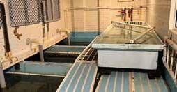
The Apollo Bay Fisherman’s Co-Op store and process live Southern Rock Lobster and abalone on site in tanks as and consumption. The commercial kitchen prepares seafood meals for take-away and consumption in their licenced area on site.
In 2023 the Apollo Bay Fisherman’s Co-Op handled 38
Apollo Bay, it traded 18 tonnes of Southern Rock Lobster sold and eaten in Apollo Bay. They provided 40 tonnes of recreational and emergency services, they employed 52 people and served 17,5000 meals.
Clear understanding of the current condition of both the harbour sea wall and the Apollo Bay Fisherman’s Co-Op building are crucial to the development of the precinct. It is understood the condition of the sea wall is deteriorating and this will be a consideration in the development as well as the heritage of the Co-op building.

Improved Co-op
Upgrade the Fisherman’s Co-op to improve commercial operations, safety and provide better integration with the public space facing the harbour. Improvements to include upgrades to food and beverage facilities, tank &
We see the following as opportunities within this scope:
· Commercial and public use.
· Upgraded kitchen with servery and connection to cold storage.
· · the harbour.
· Potential expansion to increase indoor food and beverage offering.
· Increased outdoor connection with improved public precinct and viewing deck to improve harbour and coastal views.
· Improved public safety and comfort through removing vehicle access to harbour side of building.
· Interpretive art work and signage to introduce Eastern Maar culture into the site.
Industrial
· Remove existing ammonia refrigerant system and replace with modern system to reduce spaces needed for plant.
·
· Streamline operations through improved vehicle access points for deliveries away from public space.
We see the following as constraints within this scope:
· Ensuring any commercial operation is aligned with the coastally dependent need and existing use.
· Retaining existing building fabric and heritage with new operations and complying with building code requirements. In particular existing structure.
· Ensuring value in redevelopment of existing building.
· Logistics of continued storage and processing of live lobster during construction.
· Improvements to the building without increasing height and impacting on views from the south.
Viewing Deck & Public Access
Create a new public realm with potential for viewing deck and grassed seating area that maximises views to the Apollo Bay Harbour and Otway Ranges and creates the opportunity for environmentally sustainable outdoor spaces.
We see the following as opportunities within this scope:
· Strong accessible pedestrian connection from upper to lower harbour zones and carparking.
· Adjusted position of depot, pushed back into embankment to increase viewing deck.
· Varied hard and soft surfaces and outdoor seating.
· Larger public open space with potential for expansion of festival and other public event programs.
· Opportunity to for public to observe working harbour harbour operations.
· Interpretive art work and signage to introduce Eastern Maar culture into the site and provide opportunity for visitors to engage with the cultural heritage.
· Increased use of Mother’s Beach carpark due to improved connectivity to Apollo Bay Fisherman’s CoOp and Breakwater Road.
· Opportunity for public amenities and meeting space to connect to Port Operations Depot building with separate access.
We see the following as constraints within this scope:
· Balancing public space with space licenced for use by the Co-Op for food and beverage service.
· Ensuring public use adjacent to commercial operations are well considered will be crucial to avoid safety and operational concerns.
· Careful design of the depot will be required to constraints.
· requirements.
· Extent of work and construction operations will be constrained by the need to protect adjacent
Port Operations Depot & Ocean Rescue Opportunity

Create a new Port Operations depot building with improved storage, staff areas and operational and safety features, including potential to share space with storage for Ocean Rescue vessels. Retain existing slipway and allow safe viewing of slipway use by visitors and the local community.
We see the following as opportunities within this scope
· Use the construction of the port operations depot as an opportunity to retain and stabilise the existing battered slope below the Apollo Bay Fisherman’s Co-Op.
· Improve fencing to working areas that interface with public space.
· Opportunity to provide storage space for Ocean Rescue vessels.
· The creation of meeting spaces and amenities that can be shared with sailing club and the community.
· Potential to establish links with Eastern Maar Sea Country unit.
· Landscape design delineates use to ensure safety of both visitors and workers.
· Redevelopment of the depot will create an opportunity to address existing OH&S issues on site.
We see the following as constraints within this scope:
· constraints.
· requirements.
· Ensuring safe movement of port operation and ocean rescue vessels adjacent to public access area.
· Sharing of spaces between multiple organisations including the Ocean Rescue and the Sailing Club and managing operational needs.
· Ensuring public safety around port operations including snap back zone from slipway yard and dust and noise from port works whilst retaining the working harbour experience.
· Clear understanding of the geotechnical assessment of harbour wall structure will be critical to ensure depot longevity.
· Clear information on coastal hazards and vulnerability will be required to ensure harbour edge can be responsibly developed.
