
16 minute read
Themen- & Lehrwege | Educational trails | Sentieri tematici

graduation-cap Themen- & Lehrwege
Thematic and educational paths | Percorsi tematici ed educativi ..........................................
Advertisement
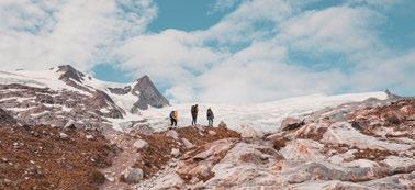
Dieser außergewöhnliche Lehrweg bietet Fitness für den Geist, Information über die interessante Alpingeschichte des Großglockners und vielfältige Einblicke in die Naturwunder dieses Berges. Auch die Beobachtung typischer Alpenbewohner wie Murmeltiere, Steinböcke und Steinadler ist für den aufmerksamen Wanderer hier gut möglich. Besonders für Familien zu empfehlen. Ausgangspunkt: Parkplatz Glocknerwinkel am Ende der Kalser Glocknerstraße (Mautstraße). Auch mit dem Wanderbus erreichbar. Gehzeit: circa 1 Std. Adventure Trail GlocknerSpur–BergeDenken. This exceptional educational trail provides fitness for the mind, information on the interesting alpine history of Mount Großglockner, and lots of insight on this mountain’s natural wonders. Observant hikers also have good chances to watch the characteristic alpine wildlife like marmots, ibexes, or golden eagles here. Particularly suitable for families. Starting point: Car park Glocknerwinkel at the end of Kalser Glocknerstraße (toll road). Also accessible by hiking shuttle. Walking time: ca. 1 h Percorso avventura GlocknerSpur - BergeDenken. Questo eccezionale percorso didattico offre fitness per lo spirito, informazioni sull'interessante storia alpina del Großglockner e tantissimi panorami sulle meraviglie naturali della montagna. I viandanti più attenti avranno anche la possibilità di osservare bene la tipica fauna alpina, come marmotte, stambecchi e aquile reali. Il percorso è particolarmente adatto per famiglie. Punto di partenza: parcheggio Glocknerwinkel alla fine di Kalser Glocknerstraße (strada a pedaggio). Raggiungibile anche in Wanderbus. Durata: circa 1 ore.
Der Weg führt eingangs durch die wildromantische, Wasser durchtoste Dabaklamm in das weite Hochtal mit alten Almhütten und intakter Landwirtschaft. Ein NationalparkLehrpfad mit Hörbäumen, bei der Stimmen spannende, lustige, aber auch erschütternde Begebenheiten aus vielen Jahrzehnten vom Leben im Almtal erzählen. Eine spektakuläre Aussichtskanzel mitten in der Schlucht, bietet für Jung und Alt ein zusätzliches Erlebnis. Schautafeln geben zudem Einblick in die Natur und Kultur dieses Almtales. Ohne besondere Schwierigkeiten ist der besonders schön gelegene Dorfersee, der einmalige Fotomotive bietet, erreichbar. Ausgangspunkt: Kals a. G./Burg/Taurer, Parkplatz Dorfertal. Gehzeit: Bergeralm circa 1 Std., Kalser Tauernhaus circa 2 Std., Dorfersee circa 3 Std. National Park History Trail Dorfertal. First, this trail leads through wild and romantic gorge Dabaklamm with its roaring waters before its leads into the wide high valley with ancient alpine huts and a functioning agricultural structure. An educational trail through the national park with talking trees which tell thrilling and funny but also shocking stories of many decades of life in the alpine valley. A spectacular prospect pulpit in the heart of the gorge is an additional attraction for young and old visitors. Moreover, illustrated information boards provide information on this alpine valley’s wildlife and culture. Being particularly beautifully situated, Dorfersee - which makes a unique photo motif - can be reached easily. Starting point: Kals a. G./Burg/Taurer, car park Dorfertal. Walking time: Bergeralm ca. 1 h, Kalser Tauernhaus ca. 2 h, Dorfersee ca . 3 h
Percorso storico del Parco Nazionale Dorfertal. Il percorso parte dalla gola Dabaklamm, romanticamente selvaggia e inondata d'acqua per giungere nell'ampia alta valle con le sue antiche malghe e le sue fattorie intatte. Un percorso guidato all'interno del Parco Nazionale con alberi parlanti, che raccontano gli avvenimenti entusiasmanti, divertenti ma anche sconvolgenti dei secoli di vita nell'Almtal. Una spettacolare cabina panoramica nel cuore della gola offre un'ulteriore avventura per grandi e piccini. Le bacheche informative offrono tante interessanti notizie sulla natura e sulla cultura dell'Almtal. Inoltre, da qui è possibile raggiungere senza grosse difficoltà il Dorfersee, che, grazie alla sua posizione particolarmente idilliaca, è un verso soggetto fotografico. Punto di partenza: Kals am Großglockner/castello/Taurer, parcheggio Dorfertal. Durata: Bergeralm circa 1 ora, Kalser Tauernhaus circa 2 ore, Dorfersee circa 3 ore
Fantasievoll gestaltete Stationen und informative Thementafeln, an den Kalser Stockmühlen vorbei, laden auf dem reizvoll gelegenen Weg zum Spielen, Entdecken und zur kreativen Beschäftigung mit der Natur ein. Wo wohnt der Dachs, was höre ich im Wald? Auf spielerische Art wird die Natur erkundet. Ausgangspunkt: Der Weg beginnt in Kals am Großglockner/Großdorf und endet beim Hotel Taurerwirt. Er ist für Familien mit kleinen Kindern problemlos zu gehen. Gehzeit: hin und retour circa 3 Std. Nature Adventure Trail Bubu Eulenweg (owl trail). Fanciful stations and informative displays alongside the Kalser Stockmühlen (watermills) invite visitors of this attractively situated trail to play, discover and learn more about the local wildlife. Where does the badger live at, what do I hear in the woods? The wildlife can be discovered in a playful way. Starting point: The trail starts in Kals am Großglockner/Großdorf and ends at Hotel Taurerwirt. It is also ideal for families with small children. Walking time: ca. 3 h (including the way back) Percorso avventura nella natura - Bubu Eulenweg. Tappe pensate con fantasia e bacheche informative a tema, passando accanto ai tipici mulini ad acqua di Kals, invitano a prender parte ad un grazioso percorso per giocare, esplorare e fare attività creative nella natura. Dove vive il tasso, quali suoni si sentono nella foresta? Alla scoperta della natura in modo divertente. Punto di partenza: il percorso parte da Kals am Großglockner/Großdorf e termina presso l'albergo Taurerwirt. È facile da percorrere anche per famiglie con bambini piccoli. Durata: andata e ritorno circa 3 ore.
Kals am Großglockner. Talrundweg Kals
Der Wegverlauf ist einfach, mit nur geringen Höhenunterschieden und lässt sich in einzelne Etappen aufteilen. Verschiedene Rast- und Themenstationen, Kinderspiel- und Aussichtsplätze sorgen für viel Abwechslung. Den Höhepunkt des Rundwanderweges stellt die Hängebrücke mit einer Länge von 55 m und einer Höhe von 28 m im Ortsteil Glor dar. Ideal für Familien mit Kindern, Senioren und auch Nordic Walking Begeisterte. Für ambitionierte Wanderer stellt die Gesamtlänge des Weges eine Alternative bei unsicherer Wetterlage dar, um eine sportliche Herausforderung unterhalb der Gipfelregion zu haben. Eine schöne Wanderung mit Abwechslung, Abenteuer, Spiel und Spaß, Information, Entspannung und Genuß! Ausgangspunkte: Kals a. G., erreichbar von allen Ortsteilen aus im Kalser Talkessel. Gesamtlänge 19,5 km. Gehzeit: circa 6 - 7 Std., einzelne Etappen mit circa 1 - 2 Std. möglich als kürzere Runden. Kals Circular Valley Route. The path’s course is easy to master, with only few differences in altitude, and can well be split into individual stages. Various way stations and thematic stops, playgrounds and lookout points ensure lots of variety. Highlight in this circular hiking trail is a suspension bridge of 55 metres length at 28 metres height in the district of Glor. Ideal for families with children, elderly people, and all those who enjoy pole walking. For ambitious hikers, the entire trail is an option in uncertain weather conditions and provides an athletic challenge below the peak region. A nice hiking tour full of variety, adventure, options to play and have fun, information, relaxation and just joy! Starting points: Kals a. G., accessible from all districts in the valley basin of Kals. Overall length: 19.5 kilometres. Walking time: about 6 - 7 h; shorter stages of about 1-2 h are possible by splitting the trail. Percorso circolare nella valle di Kals. Il tracciato è semplice, con dislivelli minimi, ed è suddivisibile in singole tappe. Varie stazioni tematiche e di ristoro, parchi giochi per bambini e panoramici offrono tantissimo svago. Il clou del sentiero circolare è rappresentato dal ponte sospeso lungo 55 m e alto 28 m nella frazione di Glor. Ideale per famiglie con bambini, anziani e appassionati di Nordic Walking Tour. Per gli escursionisti più ambiziosi, l'intera lunghezza del tracciato si pone in alternativa in caso di condizioni meteorologiche incerte per vivere sfide sportive all'interno della regione delle vette. Una bella escursione con svago, avventura, gioco, ma anche divertimento, informazioni, relax e gusto! Punti di partenza: Kals am Großglockner, raggiungibile da tutte le frazioni della conca valliva di Kals. Lunghezza totale 19,5 km. Durata: circa 6-7 ore, possibilità di dividere il percorso in singole tappe di circa 1-2 ore.
Der geomorphologische Lehrpfad führt durch den Südrand des Tauernfensters, wo sich durch die große Vielfalt an verschiedenen Gesteinen auch ein entsprechend großer Reichtum an Landschaften und Vegetation entwickeln konnte. Die 22 Haltepunkte des Lehrweges sind auf drei getrennten Abschnitten angesiedelt, in deren Zentrum sich die Glorer Hütte befindet. Lange Bergwanderung! Ausgangspunkt: Kals a. G./Lucknerhaus. Gehzeit: circa 8 Std., erster Abschnitt bis Glorer Hütte circa 2 Std., eine Begleitbroschüre ist in der Tourismusinformation Kals am Großglockner erhältlich. Geomorphological Educational Trail - Landscapes nearby Glorer Hütte. The geomorphological educational trail leads through the southern edge of the Hohe Tauern window where - due to the large variety of different kinds of rock - also correspondingly many different landscapes and plants could evolve. The 22 stations of the educational trail have been situated within three separate sections the centre of which is Glorer Hütte. Extensive mountain hike! Starting point: Kals a. G./Lucknerhaus. Walking time: about 8 h; first section to Glorer Hütte ca. 2 h; an accompanying booklet can be obtained from the tourist information office of Kals a. G.. Percorso guidato geomorfologico - paesaggi intorno alla Glorer Hütte. Il percorso guidato geomorfologico conduce lungo il margine meridionale della finestra dei Tauri, che ha visto lo sviluppo di un'ampia diversità di tipi di rocce e, di conseguenza, una ricca gamma di paesaggi e vegetazioni. Le 22 stazioni del percorso guidato sono suddivise in tre sezioni diverse, il cui centro è la Glorer Hütte. Una lunga escursione in montagna insomma! Punto di partenza: Kals am Großglockner/Lucknerhaus. Durata: circa 8 ore, prima sezione fino alla Glorer Hütte circa 2 ore, disponibile una brochure informativa presso il centro informazioni turistiche di Kals am Großglockner.
Kals am Großglockner. Blumen & Kräuterweg
Alles was die Natur zu bieten hat! Wanderweg von der Mittelstation Figollift der Kalser Bergbahnen zum Bergrestaurant Glocknerblick (1.950 m) mit Beschreibungen mittels Schautafeln von Blumen und Kräutern und deren Wirkung und Anwendung. Ausgangspunkt: Kals am Großglockner/Großdorf (1.325 m) Ziel: Bergrestaurant Glocknerblick (1.950 m). Gehzeit: von Mittelstation Figollift circa 45 Minuten, von Großdorf circa 2 Std. Flowers & Herbs Trail. All that nature has to offer! Hiking trail that leads from the central terminal of Figollift of Kalser Bergbahnen (mountain railways) to Bergrestaurant (alpine restaurant) Glocknerblick (1,950 m) and provides information panels about the flowers and herbs found here and what these can be used for. Starting point: Kals a. G./ Großdorf (1,325 m) destination: Bergrestaurant Glocknerblick (1,950 m). Walking time: from mid-station Figollift ca. 45 minutes, from Großdorf ca. 2 h Percorso tematico fiori ed erbe. Tutto ciò che la natura ha da offrire! Sentiero escursionistico dalla stazione intermedia di Figollift delle ferrovie di montagna di Kals fino al ristorante di montagna Glocknerblick (1.950 m) con bacheche informative recanti descrizioni dei fiori e delle erbe e dei loro effetti ed utilizzi. Punto di partenza: Kals am Großglockner/Großdorf (1.325 m) Meta: ristorante di montagna Glocknerblick (1.950 m). Durata: dalla stazione Figollift circa 45 minuti, da Großdorf circa 2 ore.
Öffnungszeiten
Montag-Freitag 8.30-12.00 und 15.00-18.00 Samstag 8.30-12.00 Ihr Partner in Sachen Sport & Mode. Bei uns finden Sie das passende Outfit und professionelle Beratung.
Matrei in Osttirol. Gletscherlehrweg Innergschlöß
Gigantische Kräfte der Gletscher formten einst diese Landschaft und hier in den Hohen Tauern sind sie immer noch am Werk. Der Gletscher, ein faszinierendes Phänomen, ist voller Geheimnisse. Die Beobachtungsstellen machen die landschaftsprägende Dynamik der Gletscher verständlich. Ausgangspunkt: Matrei i. O./Matreier Tauernhaus. Von dort wandert man in 1,5 Std. nach Innergschlöss. Im Talschluss beginnt der Gletscherlehrweg. Die alpine Rundwanderung weist circa 500 m Höhununterschied auf. Gehzeit: ca. 6 Std. Glacier Educational Trail Innergschlöss. A long time ago, this landscape has been formed by tremendous glacial forces. Here, at Hohe Tauern, these forces are still active. The glacier, a fascinating phenomenon, is full of mysteries. The observation points provide insight on the landscape-shaping dynamics of the glaciers. Starting point: Matrei i. O./ Matreier Tauernhaus. From here on, it takes 1.5 hours to hike to Innergschlöss. The Glacier Educational Trail begins at the end of the valley. This alpine circular walk features about 500 metres difference in altitude. Walking time: ca. 6 hours. Percorso guidato tra i ghiacciai Innergschlöß. Le immense forze dei ghiacciai hanno plasmato nel corso dei secoli questo paesaggio e qui, sugli Alti Tauri, sono all'opera ancora oggi. L'affascinante fenomeno dei ghiacciai è pieno di misteri. I punti di osservazione aiutano ad entrare nella dinamica paesaggistica dei ghiacciai. Punto di partenza: Matrei in Osttirol/Matreier Tauernhaus. Da qui si arriva a Innergschlöss in circa 1 ora e mezza. Il percorso guidato tra i ghiacciai inizia nel fondo valle. Questa escursione circolare alpina presenta un dislivello di circa 500 m. Durata: ca. 6 ore.
Matrei in Osttirol. Rundweg Almsennerei
Der Rundweg informiert in 7 Stationen zu den Themen Almdorf - Energie aus Wasser - Nachhaltigkeit - Almwiesen - Nationalpark Hohe Tauern - Almsennerei Tauer. Ausgangspunkt: Matrei i. O./Almdorf Getauer neben dem Matreier Tauernhaus, Tauer 22. Gehzeit: circa 30 Min. Circular walk - Alpine dairy. The walk informs in 7 stations about the themes pasture hamlet - energy from water - sustainability - pastures - National Park Hohe Tauern - Tauern Alpine Dairy. Starting point: Matrei i. O./pasture hamlet "Getauer" next to Matreier Tauernhaus, Tauer 22. Walking time: circa 30 minutes. Cascina in montagna. Il percorso circolare informa a 7 stazioni ai temi: borgo malga / energia dall'acqua / sostenibilità / pascoli alpini / Parco Nazionale Alti Tauri / cascina alpino. Punto di partenza: Matrei in Osttirol/malga "Getauer" vicino a Matreier Tauernhaus, Tauer 22. Durata: circa 30 minuti.
Einkehr/Treffpunkt für Wanderer und Bergsteiger! Zimmer- & Lagerbetten. 1,5 Std. gemütliche Wanderung vom Matreier Tauernhaus oder mit dem Hüttentaxi.
Alpengasthof Venedigerhaus
Tel. und Fax +43(0)4875-8820 info@venedigerhaus-innergschloess.at www.venedigerhaus-innergschloess.at
Prägraten am Großvenediger. Wasserschaupfad Umbalfälle
Vom Ausgangspunkt Ströden führt die Wanderung über die Brücke zur Gabelung Umbaltal/ Maurertal. Ein neues Eingangsportal kennzeichnet den Zutritt für die Besucher zum Lehrweg. Der Natur-Kraft-Weg erschließt die Kraft und Schönheit der Isel in Form der spektakulären Plattformen. Die Iselkatarakte an den Umbalfällen zählen neben dem Großglockner und dem Großvenediger zu den Top-Spots im Nationalpark Hohe Tauern in Osttirol. Die Schönheit dieses Natur-Phänomens erkannte man bereits 1976 und errichtete damals den 1. Wasserschaupfad Europas. Der erneuerte Wasserschaupfad an den Umbalfällen bringt den Besucher näher an die im Sommer tosenden Wassermassen von den Gletschern des Tales. Harmonisch in die Natur integrierte Plattformen machen die Kraft der Natur direkt spürbar, philosophische Zitate von Sigbert Riccabona regen zum Nachdenken an. Ausgangspunkt: Prägraten a. G./Parkplatz Ströden (gebührenpflichtig). Gehzeit: circa 2,5 Std.
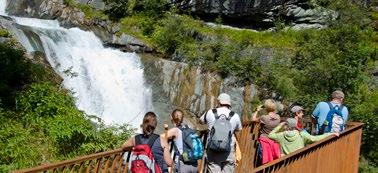
Aquatic Adventure Trail Umbal Waterfalls. From its starting point in Ströden, the hiking trail leads across the bridge all the way to the fork Umbaltal/ Maurertal. A new entrance portal marks the access to the educational trail for visitors. This nature-power trail presents the energy and beauty of River Isel on spectacular platforms. Apart from Mount Großglockner and Mount Großvenediger, the Isel cataracts around the Umbal Waterfalls rank among the top spots of Hohe Tauern National Park in East Tyrol. Already back in 1976, people recognized this natural phenomenon’s beauty and built Europe’s first aquatic adventure trail. The renewed aquatic adventure trail around the Umbal Waterfalls enables visitors to get even closer to the in summer roaring waters that come from the valley’s glaciers. Platforms that have harmonically been integrated with the environment allow for experiencing nature’s power directly, and philosophical quotes by Sigbert Riccabona inspire thought. Starting point: Prägraten a. G./parking Ströden (with fee). Walking time: circa 2,5 h Percorso panoramico acquatico Cascate di Umbal. Dal punto di partenza a Ströden, il percorso prosegue lungo il ponte fino alla biforcazione Umbaltal/Maurertal. Un nuovo portale d'ingresso segnala l'accesso al percorso guidato per i visitatori. Il percorso detto Natur-Kraft-Weg combina la forza e la bellezza dell'Isel offrendole ai visitatori da piattaforme spettacolari. Le cataratte dell'Isel presso le Cascate di Umbal sono uno dei punti di attrazione principali del Parco Nazionale Alti Tauri nel Tirolo orientale, accanto, ovviamente, al Großglockner e al Großvenediger. Già nel 1976 si riconobbe chiaramente la bellezza di questo fenomeno naturale e si decise già da allora di costruirvi il primo percorso panoramico acquatico d'Europa. Il percorso panoramico acquatico delle Cascate di Umbal, oggi rimodernato, conduce i visitatori vicino alle masse d'acqua dei ghiacciai della valle, imponenti soprattutto nei mesi estivi. Le piattaforme, armonicamente integrate nell'ambiente naturale, rendono chiaramente esperibile la potenza della natura combinandola con la riflessione filosofica su alcune citazioni di Sigbert Riccabona. Punto di partenza: Prägraten a. G./parcheggio Ströden (si applicano le spese). Durata: circa 2,5 ore.
Prägraten am Großvenediger. Blumenweg Sajatmähder
Die traditionelle, extensive Bewirtschaftung durch die Bergbauern des Virgentales schuf auf dem Weg von Oberbichl zur eindrucksvollen Sajathütte eine Landschaft, die durch ihren einzigartigen Reichtum an oftmals seltenen Blumen und Insekten weithin bekannt ist. Feuerlilien, Apollofalter und verschiedenste oft herrlich duftende Orchideen begleiten den Wanderer bei seinem Aufstieg über 1080 Höhenmeter. Diese Wanderung ist für jeden Naturliebhaber ein Muß, empfehlenswert ist, sich ausreichend Zeit zur Entdeckung zu gönnen. Gehzeit: circa 3,5 Stunden. Eine Tour für Fotofreunde.
Sajatmähder Flower Trail. Along the way from Oberbichl to the impressive Sajathütte, the traditional and extensive cultivation through alpine farmers in Virgen Valley created a landscape that is well-known for being the home of exceptionally many, frequently even rare flowers and insects. Walking up to an altitude of more than 1080 metres above sea level, hikers will come across orange lilies, small Apollo butterflies and most various orchids, some of which of wonderful fragrance. This hiking tour is a must for all those who love the wildlife. It is highly recommended to take enough time to discover all it has to offer. A trip specifically suited for all those interested in taking photos. Walking time: circa 3,5 h. A special trip for foto-enthusiasts Sentiero fiorito Sajatmähder. La coltivazione estensiva e tradizionale portata avanti dai contadini del Virgental ha contribuito a plasmare, lungo il sentiero da Oberbichl all'impressionante Sajathütte, un paesaggio famoso per la sua straordinaria ricchezza di fiori e insetti rari. Gigli selvatici, farfalle apollo e vari tipi di orchidee dai profumi magnifici accompagnano i viandanti durante la salita ad un'altitudine di 1080 m. Quest'escursione è un vero must per tutti gli amanti della natura; in particolare, si consiglia di pianificare soste sufficienti per godersi l'esplorazione della natura. Durata: circa 3,5 ore. Un percorso per gli amanti della fotografia.
Virgen. Virgener Feldflur - Flurgehölzwanderung
Schöne Rundwanderung in zauberhafter Natur mit artenreicher Tier- und Pflanzenwelt. Eine reizvolle Wanderung führt den Gast durch die kleinräumige Heckenlandschaft, die durch jahrhundertelange bäuerliche Arbeit entstanden ist. Ausgangspunkt: Virgen. Gehzeit: circa 2,5 Std. Woody Plants Hiking Tour. Nice circular hiking tour in splendid natural surroundings with rich flora and fauna. This attractive hiking tour leads visitors through the small-scale hedgerow-country that centuries of agricultural activities have formed. Starting point: Virgen. Walking time: circa 2,5 h Virgener Feldflur - Flurgehölzwanderung. Un bel percorso circolare nel cuore di un'incantevole natura con un habitat ricco di specie diverse di flora e fauna. Questa graziosa escursione conduce i visitatori all'interno di una piccola boscaglia creata dal lavoro secolare dei contadini locali. Punto di partenza: Virgen. Durata: circa 2,5 ore.
OnlineKatalog !
Ihr Fachgeschäft mit tollen Spielzeugideen

www.specklotter-matrei.at
Anja Wibmer • Specklotter Hintermarkt 3, 9971 Matrei in Osttirol Telefon +43 4875 6011 • E-Mail: info@specklotter-matrei.at
