Ensuring Safety in Adverse Weather Conditions and the Role of Advanced Meteorological Sensor Technology
Innovations in Meteorological Sensor Solutions for Adverse Aviation Weather Conditions

The Commercial Case for Meteorological Sensing Systems
Key Developments in Meteorology
Forecasts for the Aviation Sector
The Evolution of Wind Shear Detection
Weather Sensing, A Bright Digital Future
TECHNICAL STUDY Published by Global Business Media
Published by Global Business Media

Global Business Media Limited

62 The Street Ashtead Surrey KT21 1AT
United Kingdom


Switchboard: +44 (0)1737 850 939
Fax: +44 (0)1737 851 952


Email: info@globalbusinessmedia.org
Website: www.globalbusinessmedia.org
Publisher
Global Business Media
Senior Analyst
Martin Richards
Editor
Tom Cropper
Project Manager
Paul Davies
For further information visit: www.globalbusinessmedia.org

The opinions and views expressed in the editorial content in this publication are those of the authors alone and do not necessarily represent the views of any organisation with which they may be associated.
The views and opinions expressed in this publication do not necessarily express the views of the Publishers or the Editor.
While every care has been taken in the preparation of this publication, neither the Publishers nor the Editor are responsible for such opinions and views or for any inaccuracies in the articles.
© 2023. The entire contents of this publication are protected by copyright. Full details are available from the Publishers. All rights reserved. No part of this publication may be reproduced, stored in a retrieval system or transmitted in any form or by any means, electronic, mechanical photocopying, recording or otherwise, without the prior permission of the copyright owner.
ENSURING SAFETY IN ADVERSE WEATHER CONDITIONS AND THE ROLE OF ADVANCED METEOROLOGICAL SENSOR TECHNOLOGY
Contents Introduction 2 Tom Cropper, Editor Innovations in Meteorological Sensor Solutions 3 for Adverse Aviation Weather Conditions
Weipert, Head of Meteorological Information Systems, LEONARDO Germany GmbH Foreword Initial Scenario Requirements Are an Intrinsic Part The “Weather” Factor Is Key to the Overall Solution Initial Requirements Shape Solutions Holistic Sensor Solution “All Weather” Design Siting is Crucial One Coherent Message Interoperability and Data Standards Ready to Deliver The Commercial Case for 7 Meteorological Sensing Systems Tom Cropper, Editor Counting the Cost The Capacity Crisis Assessing Return on Investment Customer Relations Key Developments in Meteorology 9 Forecasts for the Aviation Sector Jo Roth, Staff Writer Accurate Real-Time Forecasting Onsite Planning Improving Wind Detection Outbound Communication The Evolution of Wind Shear Detection 11 James Butler, Staff Writer Next Generation Solutions New Devices to Detect Wind Shear Combining LiDAR and RADAR Weather Sensing, A Bright Digital Future 13 Tom Cropper, Editor The Road to AI Big Data and Connected Systems Presenting Forecasts References 15 WWW.GLOBALBUSINESSMEDIA.ORG | 1 Ensuring Safety in Adverse Weather Conditions and the Role of Advanced Meteorological Sensor Technology TECHNICAL STUDY Published by Global Business Media Innovations in Meteorological Sensor Solutions for Adverse Aviation Weather Conditions The Commercial Case for Meteorological Sensing Systems Key Developments in Meteorology Forecasts for the Aviation Sector The Evolution of Wind Shear Detection Weather Sensing, A Bright Digital Future
Andre
EVER SINCE man first took to the skies, the weather has been the enemy of progress. Today it remains the number one cause of fatalities, and also has a major impact on infrastructure. With aviation companies scratching their heads about how they will cope with an expected boom in passenger numbers, improving weather forecasting will be more than a safety issue - it could determine whether airports and airlines can cope with the challenge of satisfying demand.
Our opening article comes from German based Leonardo who manufacture a cutting-edge wind shear detection system called ShearScout. Using a hypothetical business case, they outline some of the technical and practical challenges involved with meteorological forecasting at airports.
Elsewhere in the report, James Butler will take a closer look at the next generation of wind shear detection technologies such as the ShearScout. They combine a number of scanning technologies including RADAR and LiDAR to provide a more comprehensive view of wind movements in all weather conditions. Allied to state-ofthe-art data processing algorithms, these systems give faster and more accurate readings allowing air traffic controllers to deliver prompt warnings of imminent wind shear or other disruptive weather events.
Money will also be an issue, so we’ll examine the commercial case for innovation. Safety is undeniably important, but airports must also face harsh financial realities. Even so, by running the numbers it is possible to make a convincing case based purely on commercial considerations. Effective meteorology sensing systems can reduce delays, save money and increase revenue.
Jo Roth will then run his eye over some of the most important recent advances. From improved detection systems, to advanced software which can handle trillions of calculations per second, technology is giving pilots and air traffic controllers a much more accurate view of conditions.
As we move into the future, we’ll also see how advances in artificial intelligence, machine learning and big data processing offer many exciting opportunities. They can protect passengers, save money and help airports to increase their capacity.
So, while the aviation industry has already achieved great things, it can do much more. Some technologies are already here, and others are in development. They will be crucial to how the sector manages its ongoing battles against the weather and capacity.
Tom Cropper Editor
Tom Cropper has produced articles and reports on various aspects of global business over the past 15 years. He has also worked as a copywriter for some of the largest corporations in the world, including ING, KPMG and the World Wildlife Fund.
Introduction
ENSURING SAFETY IN ADVERSE WEATHER CONDITIONS AND THE ROLE OF ADVANCED METEOROLOGICAL SENSOR TECHNOLOGY 2 | WWW.GLOBALBUSINESSMEDIA.ORG
Innovations in Meteorological Sensor Solutions for Adverse Aviation Weather Conditions
 Andre Weipert, Head of Meteorological Information Systems, LEONARDO Germany GmbH
Foreword
Without any doubt, airport and airspace resource capacity degradation occurs for various reasons such as equipment outages, staffing limitations for air traffic control, or sharing airspace with military operations. However, the most frequent and significant factors that limit air traffic capacity are adverse aviation weather conditions (convective activity, thunderstorms, wind, turbulence, etc) as mentioned, with increasing frequency, in many publications and on conferences during recent years. Modern, integrated wind shear/ adverse weather detection solutions combining different remote sensing systems such as dual polarization weather radar or scanning high power Doppler LiDAR augmented by ground based Low Level Wind Shear Alert Systems (LLWAS) are ready to deliver and already in operation. But which factors are the most relevant constraints, issues or challenges which define and influence the, perhaps, iterative implementation of these complex and combined solutions in a strategic, seamless, sustainable and “orchestrated” manner? To answer this question this article describes a conceptual project business case based on a hypothetical airport example in order to explain the overall implementation of an integrated adverse weather detection solution, starting from the requirement phase to the solution design.
Initial Scenario
The hypothetical airport (HA) consists of two crossing runways. The length of each runway is around 4000m. Both runways are operated in two directions. The provision of weather information services is already given by an Automatic Weather Observation System (AWOS) supporting typical information such as visibility conditions, surface wind speed and direction, as well as humidity, air temperature, pressure, present weather, meteorological optical range, and cloud ceiling.
The ICT (Information Communication Technology) infrastructure is in place and ICAO regulated Annex 3 products are provided. In addition to that, in the vicinity of the airport (approximately 12km to NE direction) a Doppler weather radar system (S-band radar owned by the National Hydrological and Meteorological ServiceNHMS) provides general information on weather conditions in a range of 250km around the airport. The data update rate is 15min. During the last 5 years, the HA capacity has suffered more and more from adverse wind conditions (wind in general, cross wind, wind shear) and from rapidly growing convection, since passengers and freight have increased significantly. This situation is compounded by missing glide slope information as well as a lack of high resolution (in terms of space and time) aviation weather surveillance products, concise alerts and their dissemination to various airport users. ASBU (Aviation System Block Upgrade) driven ATM (Air Traffic Management) modernization programs have been in place for the last few years and it has been recognized that many weatherrelated performance improvement targets (e.g. enhanced runway throughput) cannot be achieved. The overall situation will worsen as the HA will be extended by one more runway in the next 2-3 years.
ENSURING SAFETY IN ADVERSE WEATHER CONDITIONS AND THE ROLE OF ADVANCED METEOROLOGICAL SENSOR TECHNOLOGY WWW.GLOBALBUSINESSMEDIA.ORG | 3
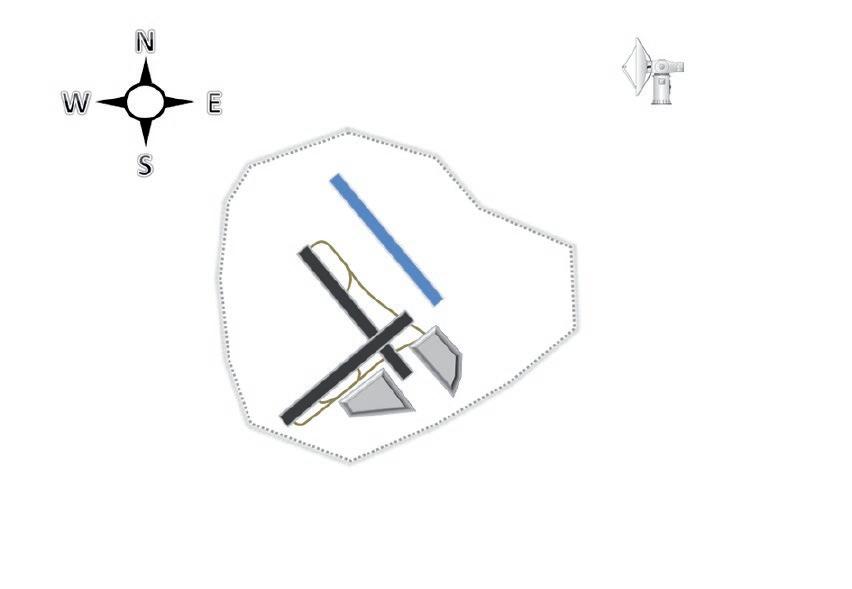
AIRPORT LAYOUT WITH TWO RUNWAYS AND NHMS WEATHER RADAR. FUTURE RUNWAY IN BLUE. THE DOTTED LINE ENCLOSES THE AIRPORT PERIMETER.
Due to the wide diversity of different conditions, initially, a one size fits all solution cannot be achieved
Requirements Are an Intrinsic Part
After executing an operational and functional gap analysis, the HA authority (HAA) decides to elevate the adverse weather detection and alert strategy in a holistic manner. In order to shape the future system, one of HAA’s most significant priorities is to find the right answer to the question “Due to the rising demand on air traffic resources, how can we better recognize and predict weather induced capacity impact?”. Due to the complexity of the anticipated enhanced weather surveillance system for HA, relevant requirements have been categorized into different areas such as a) identification of weather hazards, b) assessment of existing MET infrastructure, c) recommendations from ICAO regulations and requirements of GANP driven ASBUs (Aviation System Block Upgrade), d) understanding of operator needs, e) airport infrastructure and runway geometry, f) seamless data integration and exchange concept introducing semantic interoperability (SWIM = System Wide Information Management), g) system redundancy, availability concept and cybersecurity, i) ICT requirements, j) meteorological data provision and display, k) maintenance, training and operational sustainability and finally l) data exchange strategies between HAA and the NMHS.
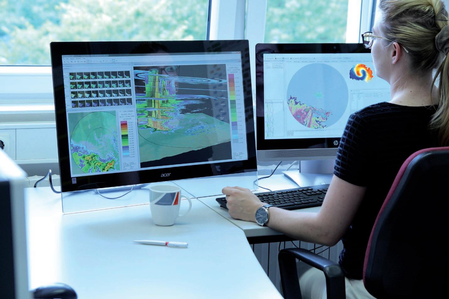
At that stage the identification of weather hazards and threats is crucial since they inherently impact the overall solution design, the sensor siting, the combined and integrated sensor solution, meteorological data provision and finally all connected backend systems which use weather information such as decision support systems, weather induced capacity impact assessment systems or other systems which convert theoretical weather information into likely outcomes.
The “Weather” Factor Is Key to the Overall Solution
Due to the wide diversity of different conditions, initially, a one size fits all solution cannot be achieved. The question here is whether the HAA should strive for initial perfection. The answer is ‘no’. More important is the need to find a flexible solution which enables evolutionary refinements over time as the implementation of solutions usually takes place over many years and can be influenced by factors which are not yet visible (e.g. regulations, weather/climate change, technology, etc.). Therefore, the most important and influencing initial requirements are a) weather detection capabilities tailored to operational needs, b) airport/aerodrome and runway coverage, c) ICT ,d) redundancy and finally e) interoperability.
Initial Requirements
Shape Solutions
In our hypothetical business case the most relevant (and representative) weather events are related to adverse wind conditions in precipitation and non-precipitation conditions (strong cross winds, tailwind, headwind, wind shear, wind speed aloft), significant rain, hail, convective activity (i.e. thunderstorm/CB cell activity) as well as related phenomena such as microbursts (dry/ wet) or gusts. In addition to that, the probability for terrain-induced wind shear and sea breezes are quite high due to the location of the HA. As regards the coverage requirements, the solution needs to be able to cover all present approach, landing and departure paths as well as the future runway. Aerodrome weather surveillance needs to be given and the general weather surveillance range for approaching thunderstorms needs to be 50-80km with a reasonable data update rate of 300sec. Glide slope surveillance for all runways (including future runways) and all runway operations will be provided according to recommended ICAO Annex 3 definitions. This results in a coverage range of 9.5km from all runway thresholds (considering a typical 3deg approach). The data update time requirement for approach and climb-out path has been defined by operators as a maximum of 60sec for all runways supporting all runway operations. As a result of many constraints (inter alia, dense airport infrastructure, land and building permissions, blockage, vegetation and future growth, power supply and security) the installation of equipment outside the airport perimeter is not possible; this constraint does not allow for any kind of installations of ground-based equipment to cover all 3NM (Nautical Mile) runway extensions. Basically these “few” core requirements will shape the overall solution.
Holistic Sensor Solution “All Weather” Design
Basically, three different solution components (as a part of the overall adverse weather detection
ENSURING SAFETY IN ADVERSE WEATHER CONDITIONS AND THE ROLE OF ADVANCED METEOROLOGICAL SENSOR TECHNOLOGY 4 | WWW.GLOBALBUSINESSMEDIA.ORG
The most frequent and significant factors that limit air traffic capacity are adverse aviation weather conditions (convective activity, thunderstorms, wind, turbulence, etc)
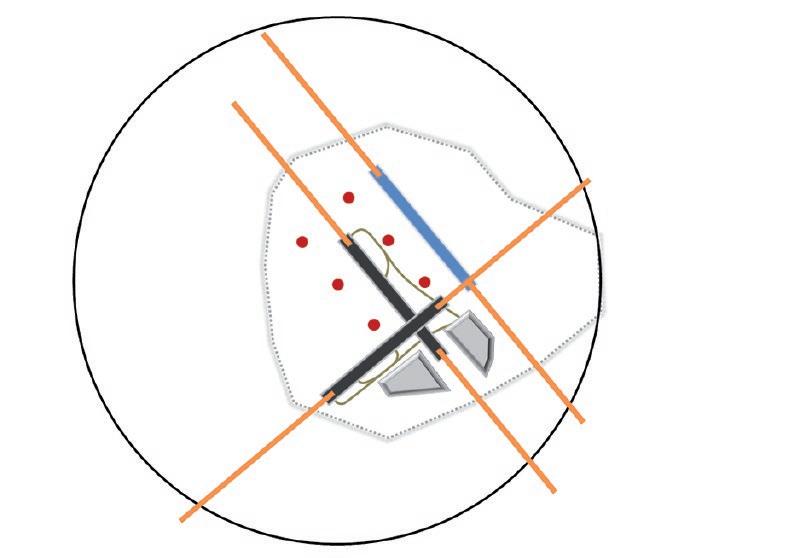
COVERAGE REQUIREMENTS FOR GLIDE SLOPES (RUNWAY EXTENSIONS 3NM). RED DOTS INDICATE LLWAS-3 SENSORS.
solution, where the solution is meant as a system of systems) are candidates to comply with the requirements. Key for the solution design is to identify which components should be used in a complementary and combined way. Glide slope surveillance (up to a height of 500m) in wet and dry weather conditions, the distinction between different types of hydrometeors and detectable range requirements require two different remote sensing systems: Dual polarization radar (typically X-band) and scanning Doppler LiDAR. The dual polarization (transmitting/receiving energy in horizontal and vertical direction) Doppler X-band radar provides volumetric information of the atmosphere such as precipitation, thunderstorm areas, wind and wind-related information (horizontal/vertical wind field, wind shear along the glide slope, turbulence) and echo classification. The operational scan range is typically up to 75100km depending on atmospheric conditions. The weather radar performance is best with the use of hydrometeors. The scanning high power Doppler LiDAR delivers volumetric information such as wind and wind-related information, also. The operational range will be up to 13km depending on the atmospheric conditions. Doppler LiDAR performance is best in clear air or “fine” weather. Both systems will operate in a combined and co-located manner since the synchronization in terms of time (data update) and space (area coverage) is essential for the correct system operation. Another complementary system is the the Low Level Wind Shear Alert System (LLWAS) This is a ground-based system processing in-situ wind data from a matrix of wind sensors (ultrasonic based) located along the runway and (if applicable) the runway extensions (3 NM to both of all runway ends). Ideally, the sensors are sited at least 1km from the centerline of the runway. Wind shear algorithms owned by NCAR’s parent organization University Corporation for Atmospheric Research (UCAR) generate runwayspecific alerts for wind shear and microburst. Due to land permission constraints and blocking by HA buildings, it is not possible to equip all runways
and extensions with wind sensors so that the coverage of all runway extensions is not given. However, coverage can be provided using the co-located radar/LiDAR combination so that the solution approach will be a combined and integrated sensor mix consisting of radar, LiDAR and LLWAS. All these elements define the holistic sensor solution design.
Siting is Crucial
The choice of the correct sensor mix is only one side of the coin; the other side may be even more important. All sensors have to be located in the most effective manner since the detectability of required weather conditions depends largely on an accurate definition of sensor locations. Due to the requirement to cover all runway paths in all operational runway configurations, it is crucial to consider whether radar and LiDAR measure the velocity of targets toward or away from the individual sensor. Keeping in mind that glide slope oriented information is essential, two main siting constraints have to be taken into account:
Firstly, the clear radial view to all runway arrival and departure paths and secondly the distance between runways and co-located radar/LiDAR combination since the coverage of even high performance scanning Doppler LiDARs is approximately 12-15km in typical operational scenarios with moderate atmospheric conditions. Additionally, the atmospheric scanning has to be as congruent as possible with the glide slope paths for all runways as well as for all runway configurations. Beyond that, siting has to be conducted in accordance with ICAO Annex 14 guidelines. However, the detectability skill of LLWAS depends on the correct implementation of the FAA Siting Order 6560.21A and needs to be assessed with appropriate simulation tools. Correct siting is always a delicate procedure which tries to balance requirements, accuracy and many local constraints (infrastructure, permissions, blocking, etc.).
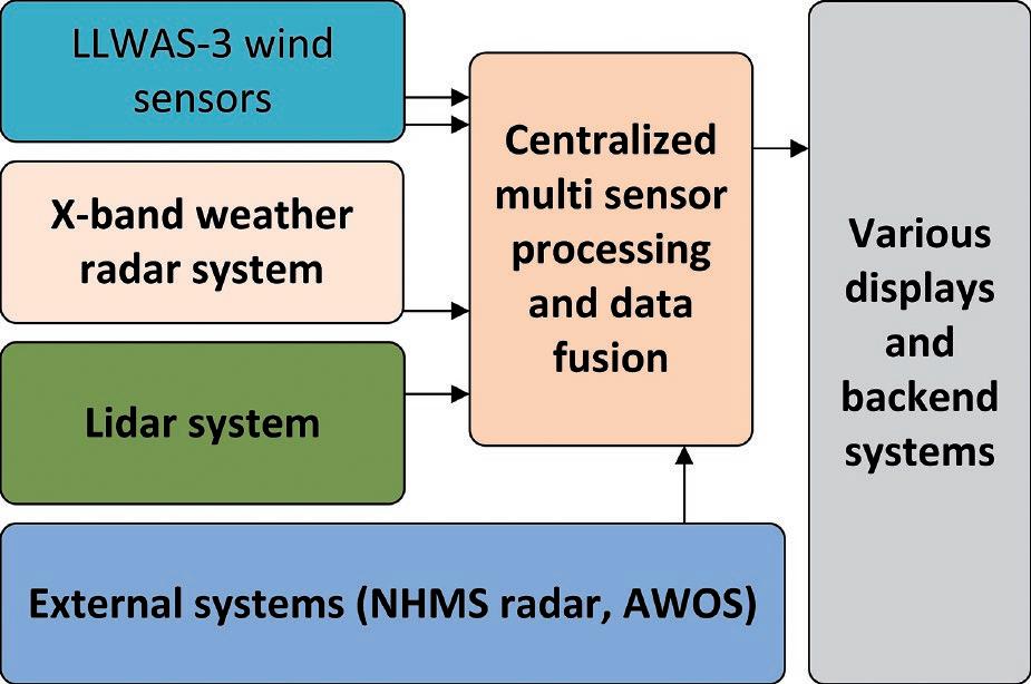
One Coherent Message
The centralized multi sensor processing and data fusion system will be an integral part of the holistic solution concept. This component will receive in-situ wind information (acquired by LLWAS sensors) as well as remote sensing atmospheric information from radar and LiDAR, and runs processing steps in order to generate coherent, tailored and fit-for-purpose combination results. The centralized data processing will follow a multi-tier method consisting of several consecutive steps. The pre-processing step
ENSURING SAFETY IN ADVERSE WEATHER CONDITIONS AND THE ROLE OF ADVANCED METEOROLOGICAL SENSOR TECHNOLOGY WWW.GLOBALBUSINESSMEDIA.ORG | 5
COMPONENT DIAGRAM FOR HOLISTIC SOLUTION
LEONARDO Germany is proud to have received major contracts worldwide in competition with a pool of international providers, attesting to its outstanding capabilities in the creation of holistic solutions for improved MET service provisions for civil aviation
improves the quality of all sensor input data - it works directly on the volumetric data (radar/ LiDAR specific atmospheric data organized in polar coordinates) providing data quality control measures such as occultation correction, attenuation correction, sea clutter and biological (insect) clutter suppression. The latter is particularly essential since insect measurements by radar may produce significant false alarms if appropriate quality measures (based on dual polarization capabilities) are not applied. The next step is the meteorological product generation which will produce dedicated meteorological products tailored to requirements such as runway-oriented wind shear, microburst and gust front detection, different vertical wind profiles, identification of storm areas and storm cores as well as short term forecast information. The subsequent step will use different operational thresholds in order to tailor (according to ATM regulations) the necessary services for operational needs. Finally, an algorithm will combine all relevant outputs from LiDAR, radar and LLWAS (smart fusion and arbitration logic) in order to produce one single alert incorporating the whole sensor mix.
Interoperability and Data Standards
Planning of the solution’s physical network will consider a seamless integration into the existing HA network architecture, taking into account appropriate obsolescence and cyber security measures. These include obsolete centralized data processing (physically separated data processing servers), dedicated and obsolete physical connections to all sensor systems (e.g. fiber optics based), authentication management, secure file transfer protocols, firewalls, and server/ client hardware wiring.
The interconnection of various different data services is crucial. The inclusion of well documented vendor specific data formats (preferably based on the XML language to enable the support of arbitrary data structures such as those used in web services) will support, also, community standards for meteorological data (e.g. ODIM_H5, UF, and NetCDF/CfRadial).
Since the solution is part of the HA ATM “ecosystem”, standards for the provision of adverse weather conditions based on Eurocontrol Asterix CAT008 will be supported. Additionally, the exchange of aeronautical meteorological information in the SWIM environment will be deemed to be particularly important since it is essential to achieve operational improvements associated with the ASBU modules described in the GANP. SWIM compliant data formats are key. For the provision of aeronautical meteorological services, IoT (Internet of Things) applications are increasingly used and the architecture solution design will have the flexibility to support point-to-point message exchange services such as AMQP (advanced message queuing protocol) and publish/subscribe respectively request/reply services such as DDS (data distribution service).
Ready to Deliver
Though the project business case refers to a hypothetical airport, the comprehensive solution design describes the ATM reality. The Leonardo concept for aviation meteorology, ShearScout®, offers a modular architecture prepared to deliver combined sensor systems tailored to operational needs and able to take into account factors such as various atmospheric conditions, operational requirements and infrastructure related constraints. ShearScout® has been designed and implemented using SESAR (Single European Sky ATM Research) derived developments and can be used seamlessly for the worldwide aviation market. ShearScout® includes a modular combination of different sensors in order to monitor, inter alia, convection, turbulence and wind shear, and to provide instantaneous glide slope and cross wind surveillance.
LEONARDO Germany GmbH is proud to have received major contracts worldwide in competition with a pool of international providers, attesting to its outstanding capabilities in the creation of holistic solutions for improved MET service provisions for civil aviation, thus enhancing its brand globally as the leader in the aviation meteorology market.
ENSURING SAFETY IN ADVERSE WEATHER CONDITIONS AND THE ROLE OF ADVANCED METEOROLOGICAL SENSOR TECHNOLOGY 6 | WWW.GLOBALBUSINESSMEDIA.ORG
The Leonardo concept for aviation meteorology, ShearScout®, offers a modular architecture prepared to deliver combined sensor systems tailored to operational needs and able to take into account factors such as various atmospheric conditions, operational requirements and infrastructure related constraints
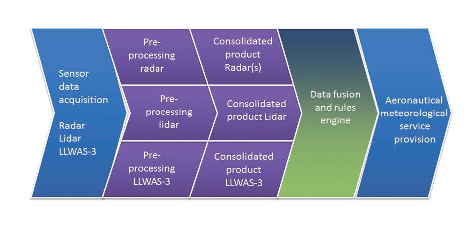
FROM DATA ACQUISITION TO COMBINED SERVICE
The Commercial Case for Meteorological Sensing Systems
Tom Cropper, Editor
The future of aviation is full of challenges. Upgrading weather forecasting capacity will help the sector meet its most urgent needs.
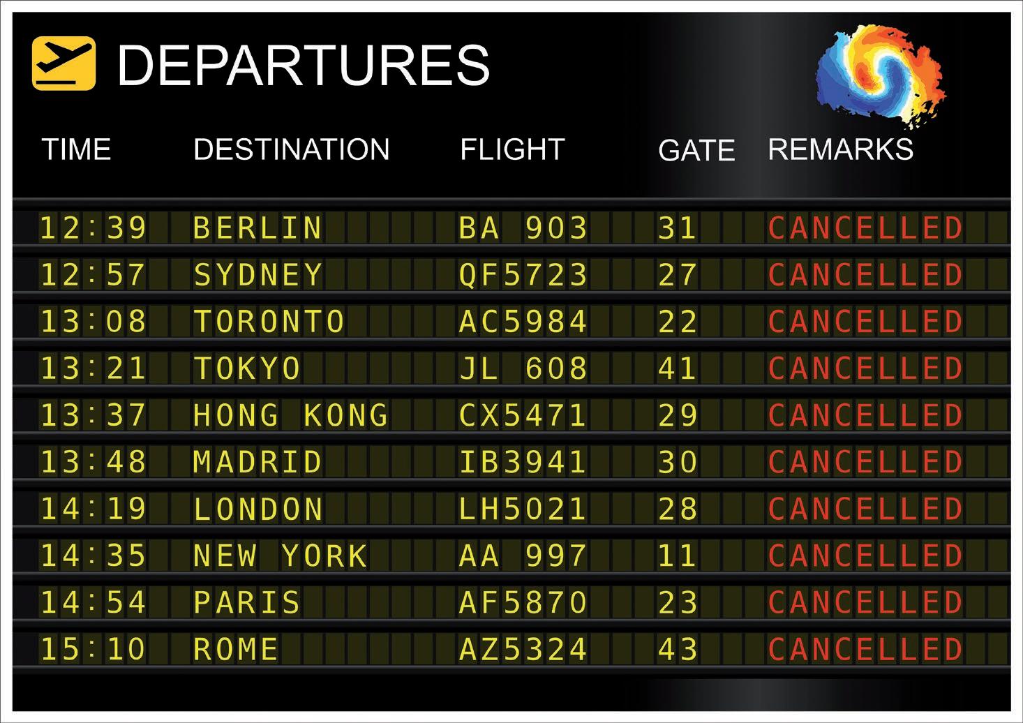
AVIATION HAS long been locked in a fight against the weather and, in general terms, it has been winning: delays are down and so are accidents, but as the skies become crowded, there is still much to do. The weather continues to cost the industry millions of dollars every year and capacity is reaching a critical level.
Counting the Cost
The aviation industry’s progress has been impressive over the past few decades. Data from the Bureau of Transportation Statistics in the US shows that weather accounted for 32% of delays at US airports in 2015, down from 50% in 20031 Moreover, the number of accidents due to bad weather is down. Even so, the weather is still a major cause of fatal accidents and also leads to thousands of delays every year.
Innovations are coming to market quickly. Developments in IT, sensors, connectivity and artificial intelligence are giving operators much more oversight about conditions, but they come at a cost. With profit margins looking increasingly fragile, innovation must make a clear commercial case.
Financial constraints often hinder innovation. Studies have shown that as many as 61% of hubs worldwide operate at a loss with only the largest international airports being able to consistently operate at a profit2. Most airports will have to turn to retail and other non-airside related activities in order to maintain their profits. The first question about any innovation will be: ‘can we afford it’?
The Capacity Crisis
When making this calculation, we first have to look at the key challenges facing the aviation world. While it may be difficult to make money through aviation, demand has never been higher. IATA’s long-term passenger forecasts predict a doubling
of passenger numbers over the next 20 years. By 2027, they believe there will be 8.2 billion air travelers with numbers growing at 3.5% per year3.
This, IATA has warned, risks a capacity crisis as infrastructure development is not keeping pace with demand4. Delivering that infrastructure is a considerable challenge. Building new airports or expanding existing ones is expensive and controversial, as the controversy over Heathrow’s proposed new runway demonstrates. Projects take decades to complete and run into opposition from politicians and campaigners.
The alternative is to manage slots and increase the capacity of existing infrastructure through efficiency improvements. Effective weather forecasting can play a crucial role in this.
The impact of weather delays is felt by much more than just the delayed aircraft. Those hubs which are particularly vulnerable to weather disruptions find it difficult to manage schedules. If flights are prone to sudden and unexpected changes due to the weather, it is difficult to allocate slots and resources.
If airport operators can improve weather predictions, they can get advanced warning of delays and make more effective plans. This minimizes the impact on schedules and boosts the operating capacity of the airport. Improvements to weather forecasting, therefore, will help airports go some way towards meeting their capacity challenges over the coming years.
Assessing Return on Investment
Increased turnaround rates will also have a direct financial return. More flights mean more passengers and more revenue. Maximizing value from existing airports will also push back the point at which expensive expansion programs will become unavoidable.
Improved weather detection systems will also reduce the number of delays, which can have an
ENSURING SAFETY IN ADVERSE WEATHER CONDITIONS AND THE ROLE OF ADVANCED METEOROLOGICAL SENSOR TECHNOLOGY WWW.GLOBALBUSINESSMEDIA.ORG | 7
IATA’s long-term passenger forecasts predict a doubling of passenger numbers over the next 20 years.
By 2027, they believe there will be 8.2 billion air travelers with numbers growing at 3.5% per year
enormous impact on bottom lines. According to a report from consulting firm MasFlight, weather flight disruptions cost airlines $1.4bn every year5 Under EU law, passengers may be able to claim compensation for delays, which means even small changes in weather conditions can push costs into the millions.
The weather doesn’t even have to cause a delay in order to create costs. Non-disruptive weatherrelated costs cover those issues which do not cause an actual delay to the flight but still carry a cost to the airline.
When estimating flight arrival times, airlines will typically plan schedules on the 65th percentile of flight times, but if weather conditions are less than ideal, journey times can increase. A headwind, for example, will slow an aircraft down significantly. A pilot can compensate by increasing thrust, but this has a knock-on impact on the use of fuel. In an environment in which airlines are being asked to reduce their carbon emissions and in which the price of oil is volatile, reducing this cost helps airlines meet their financial and environmental targets.
Customer Relations
Aside from these costs, airlines should consider the impact on customer relationships. The days when passengers felt they had to accept whatever level of service their local hubs provided are long gone. Today we are all consumers and our expectations have risen. We expect convenience, short waiting times and excellent service, so when we don’t get that while waiting at an airport, we react negatively.
That’s a problem because modern passengers have much more choice than used to be the case. Most people in the developed world now live within easy reach of more than one international hub which means they can choose which airline and aircraft they want to use. If they have had a poor experience at an airport and can get a comparatively priced flight at a nearby competitor, they will take it.
Delays represent the biggest cause of passenger stress in airports, but more than that is the lack of information. Airports can use their enhanced view of weather conditions and improved delay predictions to pass that information on to passengers in the form of social media, apps or displays in the terminal. This helps passengers to stay informed, make plans and creates the impression of an organization which has their wellbeing in mind. Innovation is also a useful public relations tool. Passengers want to travel from the best and most efficient airports available. News coverage showing a hub adopting cutting-edge technology gives the impression of an airport which is at the forefront of change. Passengers will expect a superior service at every point.
Safety will always be the most important issue, but the commercial argument is also hard to ignore. These systems improve safety, save money and drive revenue. They improve customer satisfaction and establish hubs as being leaders in innovation. In a world in which margins are fine and details matter, every advance can be critical.
ENSURING SAFETY IN ADVERSE WEATHER CONDITIONS AND THE ROLE OF ADVANCED METEOROLOGICAL SENSOR TECHNOLOGY 8 | WWW.GLOBALBUSINESSMEDIA.ORG
Increased turnaround rates will also have a direct financial return. More flights mean more passengers and more revenue. Maximizing value from existing airports will also push back the point at which expensive expansion programs will become unavoidable
Key Developments in Meteorology Forecasts for the Aviation Sector
Jo Roth, Staff Writer
Weather forecasting is a vital tool for airports as they seek to meet their most important capacity challenges over the coming years.
IN1903, as the Wright Brothers geared up for their first flight, they took the precaution of consulting with the meteorological experts to get an idea of the weather. Since then, the relationship between aviators and weather services has always been close. The aviation industry has remained one of the largest customers for meteorological services and most advances have been made for their benefit. At the same time, the industry has been pushing ahead with innovations to improve the information they have at their disposal. These innovations are constantly evolving which means the challenges developing a meteorological detection system are also changing.
Accurate Real-Time Forecasting
Having an accurate, coherent and up-to-date view of the current state of the atmosphere should be the starting point for any system. This means integrating accurate forecasts from around the world in real-time allowing operators to view weather risks as they develop. Aviation is a global industry and a problem in one part of the world can have knock-on effects across the entire network.
The Met Office uses a numerical weather prediction model which creates grid points spaced evenly around the world and produces forecasts of the atmosphere based on those readings. Doing so requires a super computer capable of making 125 trillion calculations every second6
Similarly, the FAA’s NextGen Weather Program utilizes vast computational resources as it aims to further reduce the impact of the weather on day-to-day operations7. This enables them to offer tailored weather monitoring services to their aviation clients and ensure that modern air passengers experience fewer weather-related risks than those who went before them.
One of the reasons for this vast computing power is the increasing amounts of data being generated. Improved meteorological sensing systems will increase the flow of data, but this is only as useful as the capacity to capture and analyze it.
Solutions such as WSI Predictive Airport
Analytics leverage big data analytics and machine learning to create predictions about weather patterns. This could provide airports with information about how weather may impact their operations up to 12 hours in advance, which allows them to schedule resources, determine fuel loads, and adjust schedules. It takes information about operations within an airport and uses it to predict how weather might affect flights. This includes data about congestion, taxi times and runway configuration to help planners anticipate weather delay events ahead of time8
Onsite Planning
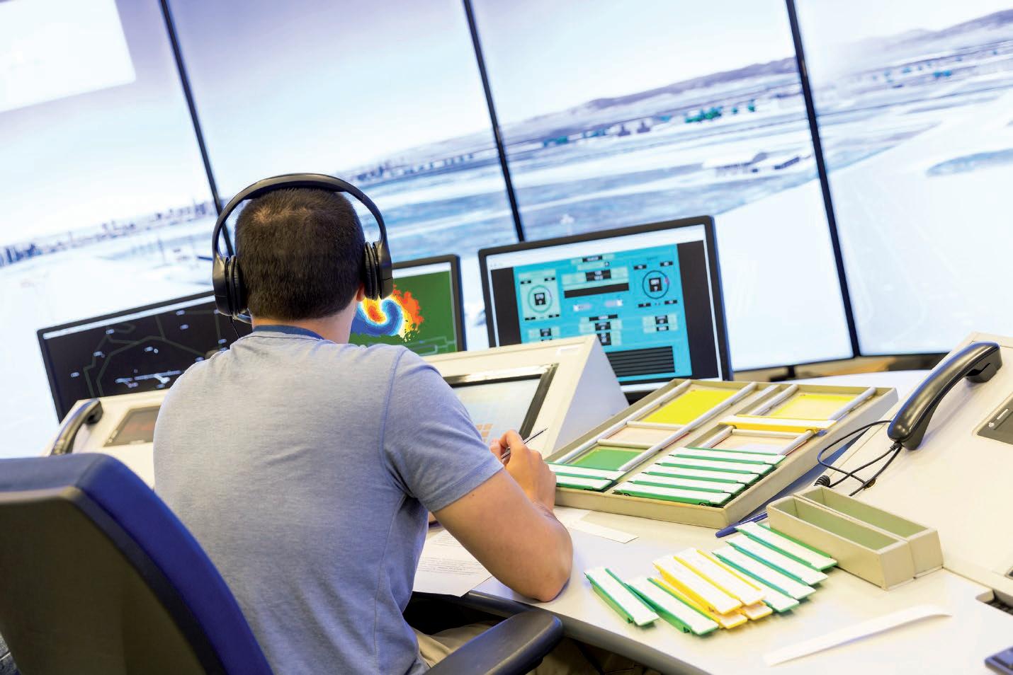
Having experts on site can improve the delivery of meteorological services. Heathrow, for example, works closely with Met Office forecasters working on site with Heathrow staff twenty-four hours a day. This helps both sides; the forecasters gain an in-depth understanding of the airport’s operations and requirements while airport staff can easily access all the information that they need about weather risk to inform their decisions. They benefit from a one-stop shop web service which is available all day, every day of the year which gives them access to specialist forecasters who provides support and assistance based on the specific challenges which impact airport operations.
Improving Wind Detection
Atmospheric hazards such as wind shear, turbulence and vortexes left by departing aircraft can be a serious problem for aircraft. Improving the detection of these phenomena is an important
ENSURING SAFETY IN ADVERSE WEATHER CONDITIONS AND THE ROLE OF ADVANCED METEOROLOGICAL SENSOR TECHNOLOGY WWW.GLOBALBUSINESSMEDIA.ORG | 9
Having an accurate, coherent and up-todate view of the current state of the atmosphere should be the starting point for any system
safety issue and it also helps operators to optimize arrivals and departures.
Recent advances in doppler LiDAR technology are helping airports to deliver remote air speed data both from the ground and from aircraft. This technology can detect dangerous gusts, wind shears around airports, and vortexes above runways. When used from aircraft, it may be able to provide advance warnings of turbulence events.
A beam of light is emitted towards the desired detection area; photons are scattered along the beam by dust particles and molecules and a small amount of light is backscattered towards the detector, below which a receiver is placed. Because these particles are so light, they mirror air movements perfectly, so they can be used to determine air speed accurately.
Different types of LiDAR are useful in different situations. At high altitude, from aircraft, particles are sparsely populated so devices can work by focusing only on light backscattered by molecules. This is known as direct Doppler LiDAR and can be used on aircraft to assess the nature of wind movements in the air ahead. This can deliver an advanced warning to pilots of any turbulence events allowing them either to prepare or avoid them altogether. However, this technology may need some maturity as the equipment needed can be quite cumbersome.
On the ground, high power coherent LiDAR may be more effective. This relies solely on backscattered light from particles which are densely positioned in the lower atmosphere. These can be used to optimize traffic by monitoring vortexes, wind shears and micro blasts in the approach and take off areas. Aircraft must maintain a minimum distance between one another on take-off, but the nature of vortexes
varies with different weather conditions. Gaining a real-time view of air movements can help air traffic controllers take accurate decisions on the basis of the real state of the air and thus optimize air traffic movements.
Outbound Communication
Airports are also beginning to realize the benefits of communicating weather risks outwards – rather than just to internal teams. Southwest Airlines has developed a sophisticated social media strategy to improve its engagement with customers9 A group of social media operatives is placed in a listening center at the airline’s headquarters gathering information such as news, travel updates and the weather. These can then be communicated to passengers via their social media channel.
This casts the information net much wider, allowing passengers and airport staff to monitor social media outputs and plan ahead. If there is an elevated weather-related risk at any time, they can see this and adjust their plans accordingly. This helps all parties organize themselves more effectively and contributes to better customer service relationships. One of the key elements of passenger stress is a lack of information. In other words, they will be more likely to accept a delay to their journey if they have more information about the problems involved.
This is why many airports now use estimated waiting time screens within airports. Expectations are adjusted and passengers are informed how long they might expect to have to wait for their turn. No longer are they working blind, wondering how long they will be stuck in limbo. Now they have a definitive end point, which reduces stress levels and improves happiness.
ENSURING SAFETY IN ADVERSE WEATHER CONDITIONS AND THE ROLE OF ADVANCED METEOROLOGICAL SENSOR TECHNOLOGY 10 | WWW.GLOBALBUSINESSMEDIA.ORG
Atmospheric hazards such as wind shear, turbulence and vortexes left by departing aircraft can be a serious problem for aircraft. Improving the detection of these phenomena is an important safety issue and it also helps operators to optimize arrivals and departures
The Evolution of Wind Shear Detection
James Butler, Staff Writer
Although it’s two decades since the last fatality, wind shear continues to create problems for airports, but a new generation of technologies is leading to more accurate visualization and faster warnings.
1985 Delta Airlines Flight 191 was coming into land at Dallas Fort Worth when it unexpectedly encountered a microburst –an intense, sudden downburst of air. It was pushed off course and landed over a mile short of the runway, striking a car and colliding with two water tankers before disintegrating. The crash killed 137 people and remains one of the most tragic examples of the dangers posed by adverse weather conditions.
In the 15 years leading up to this incident, 28 accidents and 700 fatalities had been attributed to wind shear10. An investigation into the crash blamed it on the flight crew’s decision to fly through a thunderstorm and their lack of training in dealing with microbursts.
Today, things are somewhat different. It is more than 20 years since the last fatal accident caused by wind shear, but it remains a serious hazard for aircraft. For example, in 2015 a minor accident in which an American Airlines jet slammed into runway lights while attempting to land at Charlotte was put down to a microburst11
Next Generation Solutions
The aviation market has made enormous strides in the detection of weather events over the past few years. By doing so they have managed to reduce the cost of delays significantly - but weather is still a threat. Weather-related incidents represent the biggest cause of fatalities every year12. Turbulence and adverse wind conditions continue to cost the industry millions and cause injuries to both passengers and crew.
Wind shear detection systems have made things much safer and have reduced dramatically the number of incidents, but there are still gaps in the system. Different detection systems are more suited to certain conditions. Data processing depends on the sophistication of algorithms used to process and analyze this data and interface systems need to provide clear and prompt alerts to air traffic controllers.
A new generation of technologies is on the way which provides advance warnings of sudden shifts in wind. This could be enough to allow pilots to take avoiding action or at least to warn them when turbulence is approaching.
New Devices to Detect Wind Shear
One of the most exciting innovations comes in the form of the ShearScout. Coupled with an effective sensor system, this device can offer effective monitoring of conditions around an airport and allow air traffic control to warn pilots of imminent wind events.
This ground-based, low level wind shear avoidance system (LLWAS), is a turn-key solution. It automatically detects low altitude wind shear events such as microbursts within the take-off and landing sectors. It then uses algorithms to calculate the location and strength of those wind shifts and, if it has detected dangerous low-level wind shear conditions, it issues an alert which can be transmitted from air traffic control to the pilots.
The device captures data about the wind from a series of ultrasonic wind sensors located along the runway and glide slope. These must be sited at least 1km from the center line of the runway and more can be added at any time.
The system then transfers wind information to a dual hot back-up server by radio link where it is processed by a Phase 3 wind shear algorithm developed for the FAA by the National Center for Atmospheric Research (NCAR).
Combining LiDAR and RADAR
The system represents an improvement over alternative approaches thanks to its combined use of different sensor technology and its enhanced data management features. This enables it to cover gaps which are often left by other LLWAS systems, such as the detection of clear air turbulence (CAT). This is one of the most dangerous types of wind events as it
ENSURING SAFETY IN ADVERSE WEATHER CONDITIONS AND THE ROLE OF ADVANCED METEOROLOGICAL SENSOR TECHNOLOGY WWW.GLOBALBUSINESSMEDIA.ORG | 11
IN
This ground-based, low level wind shear avoidance system (LLWAS), is a turnkey solution. It automatically detects low altitude wind shear events such as microbursts within the take-off and landing sectors
is extremely difficult both for pilots and some warning systems to detect. Because this occurs in clear air, there are no cloud movements to provide a visual warning.
The ShearScout identifies this by combining Doppler RADAR and LiDAR technology. The radar technology delivers continuous three-dimensional scanning of the surrounding atmosphere and is ideal for detecting wind-related events in wet weather - but it is limited in dry conditions. Here conventional radar often fails to identify wind shifts, which can present a serious danger to aircraft.
These sudden and unexpected shifts in wind can cause violent movements resulting in damage to the aircraft and injuring passengers. On approach, they can also throw aircraft dangerously off course. To identify CAT, the ShearScout turns to light detection and ranging (LiDAR) technology. These use much shorter wavelengths which are reflected by aerosol particles in the atmosphere which make it possible to identify wind phenomena in clear air conditions. However, this suffers in wet conditions as the ray of light is absorbed by water particles.
It is the combination of LiDAR and RADAR which allows the system to be accurate in both wet and dry conditions. However, there is a third element which often goes overlooked – data processing. The ShearScout benefits from one of the world’s leading processing software, Rainbow 5, which uses state-of-the-art algorithms, data fusion capabilities (Radar, LiDAR, LLWAS) as well as cutting-edge nowcasting capabilities. This allows it to deliver clear and detailed information such as wind profiling, profiling horizontal winds, quantification of runway orientated speed loss or gain, alerts for microbursts and severe weather warnings.
This is a sign of where technology has to go. Although detection capabilities have improved significantly, there are still gaps. The rise of devices which can incorporate the benefits of different technologies increases the effectiveness of systems in all weather conditions. Pilots are given much more confidence knowing that someone will spot the hidden dangers that the wind can throw at them.
ENSURING SAFETY IN ADVERSE WEATHER CONDITIONS AND THE ROLE OF ADVANCED METEOROLOGICAL SENSOR TECHNOLOGY 12 | WWW.GLOBALBUSINESSMEDIA.ORG
It is more than 20 years since the last fatal accident caused by wind shear, but it remains a serious hazard for aircraft
It is the combination of LiDAR and RADAR which allows the system to be accurate in both wet and dry conditions. However, there is a third element which often goes overlooked – data processing
Weather Sensing, A Bright Digital Future
Tom Cropper, Editor
Connected devices, machine learning and big data will play an important role in the future of meteorology sensing for the aviation industry.
TEN BILLION people could be travelling by air by the year 2040, which means capacity will be stretched to the limits. While the aviation industry has already made great strides in reducing weather-related delays, it will have to do much more if it is to meet capacity challenges. The good news is that a new generation of technologies is moving to the fore which will enable it to do exactly that. From machine learning to Artificial Intelligence (AI) and the internet of things, innovation can transform the sector’s understanding of weather conditions.
The Road to AI
AI will play an increasingly important role across many aviation operations, with one of the key areas of development being forecasting delays.
In 2017, SITA Labs began to develop a Crystal Ball system to use AI to predict flight delays. It now says it has the capacity to accurately predict delays up to six hours before their expected arrival.
With the power of machine learning, they can take data which is already commonly available and use it to provide accurate forecasts about flight delays. The system was successfully used in partnership with an Asian Airport which was having difficulty scheduling runway slots and allocating the right resources for aircraft. The airport struggled to predict its traffic thanks to a number of issues including challenges with the weather. SITA was able to use weather forecasts, along with other information, to accurately predict delays.
“When we approached the airport, they were excited by the possibility that we could provide predictions on flight arrivals. Over a six-month period, we used various sources of information such as weather, NOTAMs (notice to airmen), flight movements and other flight data to predict six hours ahead of the expected arrival time,” says SITA Labs’ Thierry le Gall13
“Using sophisticated algorithms, we were able to provide an accurate prediction of within 15
minutes of the flight arrival for around 80% of flights six hours before touchdown. Building on our successes, we are improving the prediction accuracies as well as extending the predictions up to 12 and 24 hours before gate arrival.”
The system enables airports to schedule and allocate all resources in a much more efficient way to minimize disruption caused by delays and to optimize turnaround times. While this system may work better in some places than others, machine learning is developing rapidly.
Big Data and Connected Systems
A key element of AI’s value proposition is data. As digital technology becomes deeply embedded within aviation systems, the amount of data that operators can gather is mushrooming. The International Civil Aviation Organization (ICAO) predicts that air passengers could grow from the 2017 figure of around 4bn to 10bn by 2040 with 90 million departures taking place around the world. All those passenger numbers are going to generate data14
Meanwhile, improved weather monitoring systems will increase the quantity and quality of weather forecasts and the internet of things (IoT) will harvest data from all sorts of different quarters.
Using IoT technology, airports can connect weather sensing beacons on runways to the airport’s central network, delivering more accurate real-time metrics on weather conditions. This data can also be integrated with customerfacing mobile apps, giving alerts such as weather updates and any probable weatherrelated delays.
These innovations enhance the level of realtime data, including areas which might previously have been isolated such as one place where it is needed most – the cockpit. Thanks to a lack of connectivity in cockpits, pilots are often cut-off from important data, relying on directions from air traffic control. This can still leave them vulnerable to short-notice changes in conditions such as turbulence.
ENSURING SAFETY IN ADVERSE WEATHER CONDITIONS AND THE ROLE OF ADVANCED METEOROLOGICAL SENSOR TECHNOLOGY WWW.GLOBALBUSINESSMEDIA.ORG | 13
The way in which data is presented is also evolving from traditional text-based systems to graphical interfaces
Now, though, The Weather Company and Gogo Business Aviation have teamed up to use IoT technology to deliver enhanced turbulence warning solutions to cockpits. It has developed a turbulence detecting algorithm called TAPS, which can be placed on Gogo’s Aircraft-Based communications server. Pilots can see developing turbulence in real-time and take immediate action. This, they say, could reduce the $100 million lost every year due to turbulence through injuries to passengers and crew15
Turbulence detection systems are some of the most popular technologies among pilots and a number of other solutions are being tested to evaluate their use. Boeing, for example, is experimenting with a system which shoots lasers from an aircraft’s nose and promises to give pilots a 60 second warning before turbulence strikes16
Hawaiian Airlines uses an Eddy Dissipation Rate Based Global Turbulence modelling system which helps prevent clear air turbulence17
Presenting Forecasts
The way in which data is presented is also evolving from traditional text-based systems to graphical interfaces. In the US, the AOPA has been working with The National Weather Service’s Aviation Weather Summer Testbed to evaluate Graphical Forecasts for Aviation.
“The GFA provides the entire aviation community with the latest advances in aviation weather combined with the NWS’s best authoritative aviation information,” said Clinton Wallace, deputy director of the Aviation Weather Center in a statement. “It is the foundation upon which future advancements are being built, ensuring the community will see continual improvement of the GFA for years to come.”
Although only at the evaluation phase, evidence suggests it is receiving positive feedback from pilots and that more and more of them are going online to get their weather news18
Innovations such as these focus on the entire spectrum, from sensors and detection systems to interfaces which allow for the presentation and evaluation of data. Brought together they provide airlines and airports with an impressive new arsenal of weapons to fight against their age-old enemy – the weather.
ENSURING SAFETY IN ADVERSE WEATHER CONDITIONS AND THE ROLE OF ADVANCED METEOROLOGICAL SENSOR TECHNOLOGY 14 | WWW.GLOBALBUSINESSMEDIA.ORG
“Using sophisticated algorithms, we were able to provide an accurate prediction of within 15 minutes of the flight arrival for around 80% of flights six hours before touchdown”
Thierry le Gall, SITA Labs
Improved weather monitoring systems will increase the quantity and quality of weather forecasts and the internet of things (IoT) will harvest data from all sorts of different quarters
References:
1 Keeping One Step Ahead of the Game with Airport Weather Forecasting: https://www.airport-technology.com/features/featurekeeping-one-step-ahead-of-the-game-with-airport-weather-forecasting-4940501/
2 Airport Financial Results: https://centreforaviation.com/analysis/reports/airport-financial-results-1h2015--primary-airports-hubs-alliances-retail-sustain-profitability-240555
3 IATA Forecasts Predict 8.2bn: https://www.iata.org/pressroom/pr/Pages/2018-10-24-02.aspx
4 Global Airport Capacity Crisis Amid Passenger Boom: https://phys.org/news/2018-06-global-airport-capacity-crisis-passenger.html
5 Weather Flight Disruptions Cost $1.4bn: https://www.cnbc.com/2014/01/08/weather-flight-disruptions-cost-14-billion-data.html
6 Always be Prepared: The Importance of Winter Weather Forecasts: https://www.internationalairportreview.com/article/76669/always-be-prepared-winter-weather/
7 Next Gen Weather: https://www.faa.gov/nextgen/programs/weather/
8 The Next Wave in Airport Efficiency: Predictive Analytics: https://www.aviationpros.com/aviation-security/article/12167395/airport-predictive-analytics
9 Social Media LUV: How Southwest Airlines Connects with Customers Online: https://www.bizjournals.com/dallas/news/2019/03/03/southwest-airlines-social-media.html
10 Review of Accidents Caused by Wind Shear: https://www.researchgate.net/publication/292899205_Review_of_Avation_Accidents_Caused_by_Wind_Shear_and_Identification_Methods
11 A Terrifying Weather Phenomenon Nearly Causes an American Airlines Jet to Crash: http://bit.ly/2Lh7XBY
12 NTSB Safety Study Looks at Weather Related General Aviation Accidents:
https://www.ntsb.gov/news/press-releases/Pages/NTSB_Safety_Study_Looks_at_Weather-Related_General_Aviation_Accidents.aspx
13 Using Artificial Intelligence to Predict Flight Delays:
https://www.sita.aero/air-transport-it-review/articles/using-artificial-intelligence-to-predict-flight-delays
14 The World of Air Transport in 2017: https://www.icao.int/annual-report-2017/Pages/the-world-of-air-transport-in-2017.aspx
15 Partnership Uses IoT Data to Improve Aviation Safety: https://www.engineering.com/IOT/ArticleID/12447/Partnership-Uses-IoT-Data-to-Improve-Aviation-Safety.aspx
16 Boeing Planes Could Fire Lasers: https://www.wired.com/story/boeing-jaxa-turbulence-LiDAR-laser/
17 Ensuring Safe and Efficient Flight Operations Worldwide for Hawaii’s Largest Airline: https://dtn2.flywheelsites.com/wp-content/uploads/2017/10/Ensuring-safe-and-efficient-flight-operations-worldwide-for-Hawaii’s-largest-airline-Case-Study.pdf
18 What’s Next for Aviation Weather Forecasting:
https://www.aopa.org/news-and-media/all-news/2018/september/20/what-next-for-aviation-weather-forecasting
ENSURING SAFETY IN ADVERSE WEATHER CONDITIONS AND THE ROLE OF ADVANCED METEOROLOGICAL SENSOR TECHNOLOGY WWW.GLOBALBUSINESSMEDIA.ORG | 15
