

1. Introduction - Defining the area and analyzing the territory
2. The Strategy - Explaining the three pillars and spatializing them
3. The focus area - Narrowing down the area to prioritize the requirements of the territory
4. The Masterplan
5. The creation of the Bike Network - Broadening the concept of accessibility
6. The Bike Hubs - Broadening the concept of attractivity with an eye toward sustainability
Introduction
▪ The S13 line
▪ The catchment area
▪ The indicators
▪ The classification of the stations


Duringtheanalysis,wedecidedtofocusonthe isochronesofbicycleandwalking,movingawayfrom considerationoftheisochroneofthecar.
Thereforea ourcatchmentarea wascreatedtosetan orientationfortheupcomingstrategythatisfocusedon sustainableandactivemobility.
Inourprojectwewantto minimizethedistances that existinthearea,andwewanttodothisby increasing theuseofbicycles byimprovingthelightmobility systeminavarietyofways


Locate Triulzi

THE BALANCED STATION
”on one side the city on the other the shopping center”
Pieve Emanuele
THE STATION ON THE CORNER
”the park as a green wall”
Villamaggiore
THE STATION IN THE ARCHIPELAGO
”disputed between the two islands of Siziano and Lacchiarella”

Certosa di Pavia
THE EXCLUDED STATION
”far and not accessible”
Balanced supply
Very good connectedness
Compact town with growth around the station
High amount of local services, but not at the station
Very good connectedness
Parco Agricolo Sud Milano as a barrier and potential
Few services around the station
No bus stops in the station neighbourhood
Regional bike lane reaching the station
Poorly equipped with services
Huge distance to the next bus stops
Poor walkability around the station
▪ Objectives and actions
▪ Detailed strategy
▪ The timeline

● Revitalization and densification of the surroundings of the stations.
● Re-connecting and re-sewing the different settlements with the stations.
● Points of intermodality: interaction between different means of transport that need a reconnection in a more dense network.

● Areas of sustainability focus.


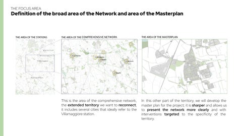
we narrow down the area to focus on a transect that has specific needs.

extendedterritory ,
it includes several cities that ideally refer to the Villamaggiore station.
master plan for the project; it is sharper and allows us to present the network more clearly and with interventions targeted to the specificity of the territory.
4The Masterplan
▪ Development of the network - the “lines” and “dots” concept
▪ The Masterplan “Connecting through active mobility to strengthen the S13 line
In the masterplan we find the result of the three pillars united together to form the new network.
A network is composed by lines and dots, the lines are the bike lanes and the dots are our bike hubs.
All the measures have been adopted to pursue accessibility, attractivity and sustainability.
Through“lines”and “dots”thenetwork reconnectsthe territoryfacilitating themobilityand directingtheflows ofpeopletowards thestationof Villamaggioreand theS13line


The Creation of the bike network
▪ The “copenhagenize” model
▪ The analysis of the current network
▪ The implementation of the measures
Let’s start by seeing how we develop the intricate network of bike lanes with in efficiency and safeness in mind
We do so following the Copenhagenize method

Homosapiens lose the ability objectstheyencounter as their speed increases.


The idea is the willingness to reverse the paradigm of the automobile-centered society.
From “How many cars we can move down the street” to “How many people we can move down the street”.


40 40 50 -
Cycling on the street & traffic calmed areas
under Category 4
Hard separated bike lane with physical protection
Category 2
Painted bike lanes along the sidewalks
Goal to keep cyclist as far away from the road as possible

THE ANALYSIS OF THE CURRENT NETWORK
MAPPING EXISTING BIKE LANES
ADDING NEW BIKE LANES
ANALYSING SPEED LIMITS
ADOPT THE MEASURES
Showthe existing bike network and theircurrentstatus.
Dividedintoroads, pedestrianandbike lanes.
Enlarging the existingnetworkin ordertoadd new bike lanes where neededanddefining theareasinwhich newconnections couldarise.
Analysing the speed limitsalongthe desired final network tobeabletoputthe bikelanesintothe categories ofthe copenhagenizemodel.
Adopting the measures toimprove adtobuildnewbike lanes in compliance with the four categories ofthe copenhagenize.

This, according to “open street map” data, is the existing bicycle network. We mapped and analyzed it and found that the physical condition and the proportion of the road that different modes have to share is uneven andinefficient.
Network Reference: Open Street Map

Basedontheprevious analysis, we imagined what other lines might be useful to add to the existing network for developing.


Based on the Copenhagenize model, we decide to analyze the average speed that cars have to respect in the streetnetworkthatwe are considering and that will form the new bikenetwork.

“Midblock Crosswalks.” National Association of City Transportation Officials, 11 July 2013, nacto.org/publication/urban-street-design-guide/intersection-design-elements/crosswalks-a nd-crossings/midblock-crosswalks/.

“Curb Extensions.” National Association of City Transportation Officials 11 July 2013, nacto.org/publication/urban-street-design-guide/street-design-elements/curb-extensions/.


● addition of light poles
● linear planting of new
● addition of bollards


● addition of light poles

● linear planting of new trees

● traffic-calmed two-way street
● street-calming islands
● bike and car share the street

● addition of light poles on both sides of the street


● removal of parking spot line

● painting the bike devoted lanes
● bike and car going on opposite directions side-by-side

● addition of taller light poles on both sides of the street

● removal of parking spot line

● painting the bike devoted lanes
● adding physical separation between car and bike (bollards)

● bike and car going on opposite directions side-by-side

● addition of tall light poles on both sides of the street

● putting the bike lane as further as possible from the cars

● using the river and its border’s trees as a buffer


Copenhagenize Design


Company concept for used-activated light signal
Cyclist handle prototype

Angled bike trash-can in Copenhagen
Fence designed with a bike oriented mentality for bikers to rest

6 The Bike Hubs
▪ Development of attractivity and services through the Bike Hubs
▪ The redesign of the surrounding of the Station following the three pillars
The system of the Bike Hubs
Attractivity is provided through the distribution of important bike hubs to facilitate life of the people. Sustainability is the lens through which every aspect of our strategy is conceived

Secure bicycle parking in a dedicated facility outside the main train station in Washington, DC.
Charging and maintenance columns equipped with maintenance tools and tire inflation pump with universal attachment


Highly accessible hub located close to the train station. It is equipped with bike parking, bike sharing and bike repair shop. A rest area with benches andotherfacilitiesisrightbehindit.


Bike hub in central areas of towns. Point of interconnection to local supply facilities, residential use and public transport.Highfocusonbikesharingand resting areas. Equipped with a self-repairing station. High focus on the intermodalitybetweenbusandbike.


Locatedintheresidentialareaofthecity, equipped with bike parking, sharing and self-repairing station. High focus on the intermodality between bus and bike. This bike hub is located next to a school to serve the students that want to move independently.


Bike Hub in the surrounding of workplaces, in these cases inside of logistic and commercial used areas. Equipped with sharing and bike parking. Important for these hubs are the buildings with locker rooms and showers inside, to make biking to the workplace moreattractive.


Through the visualization of the close-up of the station it is possible to see the the detailed application of the 3 pillars, also through a comparison of the pre and post intervention.
▪ Two concreteparkinglots

▪ Roundabout thatimpedes thefreewalk
▪ Unequipped stationwithout restingzones
▪ Unusedgreenareas
trappedbetweenthestreets andthefactory
▪ Absenceofbikeracks
New State
▪ Bikehub
▪ New greenrevitalizedarea

▪ Polyfunctionalfacilityfor study andwork
▪ Playground
▪ Work-outarea
▪ Multi-sportcourt
▪ Shaded Boulevard
underground level

Anew branching for bikes thatallowsforsmoothertraffic flow

The station's bike hub where peoplecansecurelydropoff theirbikesandprofitfromad hocbikerepairservices
An improved underpass that allowsbicyclestopassthrough, increasingthespacearound thestation The factory's bike hub for theworkerstousetheshower serviceandlockers
Animprovementofthe existingsoccercourttocreate anew multi sports court equippedwithmultiple activities
Anew multi-purpose, equipped study-work area forS13lineriders
Anew playground immersed inthe new green area for childrentoplayandforpeople torelax
Therevaluationofadisused greenareatocreatea green oasis for fitness and jogging

Green depaving and pedestrianization ofthe entireareainfrontofthe stationtocreateanenjoyable andsaferenvironment
Thenewdecementifiedand permeable green parking area
Thenew green boulevard towardSizianotocreatea shaded area separatedfrom cars
Thenewgreen oasis for exercising and relaxing in nature

New State
▪ Bikehub
▪ New greenrevitalizedarea
▪ Polyfunctionalfacilityfor study andwork
▪ Playground
▪ Work-outarea
▪ Multi-sportcourt
▪ Shaded Boulevard
underground level
Through“lines”and “dots”thenetwork reconnectsthe territoryfacilitating themobilityand directingtheflows ofpeopletowards thestationof Villamaggioreand theS13line
Flussi Stazioni Ferroviarie, Dati Lombardia, Access:
<https://www.dati.lombardia.it/Mobilit-e-trasporti/Flussi-Stazioni-Ferroviarie/m2u2-frtq/data> In: October 2022
DUSAF6 Files, Geoportale Regione Lombardia, Access: <https://www.geoportale.regione.lombardia.it/> In: October 2022
DBT Data Pavia and Milan, Geoportale Regione Lombardia, Access: https://www.geoportale.regione.lombardia.it/metadati In: October 2022
ISTAT, Access: <https://www.istat.it/it/dati-analisi-e-prodotti/banche-dati/statbase> In: October 2022
Bike, Car and Walking Isochrones, ORS, Access: <https://openrouteservice.org/> In: October 2022
Base Map Data, Open Street Map, Access: <https://www.openstreetmap.org/#map=16/45.3620/9.2231> In: October 2022
Mikael Colville-Andersen. Copenhagenize: The Definitive Guide to Global Bicycle Urbanism. Island Press, 2018.
Topography sections, Google Earth Pro, Access: <https://earth.google.com/web/> In: October 2022
Bus Stations Locations and Frequency of Buses for Pavia, Google Maps, Access: <https://www.google.com/maps> In: October 2022
Bus Stations Locations and Frequecy of Buses for Pavia, Moovit, Access: <https://moovitapp.com/milano_e_lombardia-223/lines/1/641236/1/it?ref=2&customerId=4908> In: October 2022
Bus Stations Locations and Frequency of Buses for Milan, Agenzia TPL, Access: <https://www.agenziatpl.it/open-data/gtfs> In: October 2022
Plugins - QGIS: ORS, QuickOSM