

POSSIBLE FUTURES
Selected Works_German Penaranda

PALIMSETS

CANTERA_TALLER DE ARQUITECTURA
CONTENT
PG 20 PG 54 AIRU PG 4

ONCE IT WAS A WETLAND
PG 34

BETWEEM CLOUDS
PG 44
“If we start with the presupposition, striking perhaps but not totally far fetched, that the contemporary world can be considered a massive design failure, certainly the result of particular design decisions, is it a matter of designing our way out?"
Designs for the Pluriverse, Arturo Escobar

Buenavista Indigenous Reservation or PUT 12 Oil Well Putumayo, Colombia
Research Collaborator : Sebastian Conejo
November 27, 2020.
British oil company Amerisur released a press statement reiterating that “all its operations in the Amazon jungle are carried out under the highest socio-environmental and operational standards(...) with full respect for human rights.”
This is the photo used in that press release.
AIRU 0°28’11.3”N 76°17’18.1”W


FROM RUBBER TO OIL


The Sionas, an Indigenous Amazonian culture nearly eradicated by the rubber extraction industry in the 1920s were recognized in 2010 in threat of “physical and cultural extermination” by Colombia’s Constitutional Court.


Confined to the ‘Buenavista Indigenous Reservation’, the Sionas resisted British oil company Amerisur’s exploration of the PUT-12 oil block amidst escalating threats of oil spills, noise pollution, deforestation and assimilation into capitalism.


AIRU is a speculative project proposal of a Possible Future in which, the Sionas, preempt cultural extinction by repurposing an oil infrastructure well into a ‘chagra’, an ancient agricultural system embodying traditional knowledge and cultural practices.


By 2030, once the “chagre” is consolidated, a physical representation of the Siona worldview is built as an infrastructure to perpetuate their knowledge and culture, using the old oil drilling pipes.


 Fig. 6 / Cartography: Putumayo today: oil exploration
BUENAVISTA - SIONAS INDIGENOUS RESERVATION PUTUMAYORIVER AMERISUR PUT-12 OIL BLOCK
Fig. 7 / Landsat imagery portraying amazon deforestion around Bellavista Indegenous Reservation


RESERVATION
Buenavista
1999 2020
1991
Buenavista
PUT 12 PUT 12 PUT 12
Buenavista
Buenavista Indigenous Reservation National Parks Oil wells
Oil exploration permits
Conejo
Year 2030. The Sionas occupy the PUT12 oil well. The forest cleared by the oil well is used to create a ‘chagra’, a multicrop farming system/infrastructure that provides food on a 10 year cycle and allows the jungle to regenerate itself.
The following are a series of research drawings of this infrastructure, applied to the PUT-12 Oil Well.
Collaborators: Sebastian
Fig. 1 / Chagra’s
201 200 199 200 201 202 199
crop planting scheme, each color respresnts a different species.
CHONTADURO

Over its lifespan, the project anticipates ecological succession where various species will flourish, transforming the area.

Within ten years, fruit trees will attract wildlife, eventually converting the site back into a jungle once its productive phase concludes.

AIRU / Academic Project / rd year
Chagracrops on year 5
Chagracrops on year 5
Chagracrops on year 1
Fig. 2 / Chagra’s 10 year cycle, from plantation to jungle
Chontaduro (Bactris Gasipaes)
Caimo Lechero (Pouteria caimito)
Uva Caimarona (Pourouma cecropiifolia)
Guacuri (Poraqueiba sericea)
Guamo (Inga edulis)
Yuca Brava (Manihot utilissima) Yuca Manicuera Piña (Ananas comosus) Mafafa
Yuca Dulce (Manihot aipi )
Maraca (Theobroma bicolor)
(Xanthosoma sagittifolium)
Coca (Erythroxylum coca)
Platano (Musa Paradisiaca) Caña Brava (Gynerium sagittatum) Maíz (Zea Mays) Tabaco (Nicotiana Tabacum)
Garden Design Studio: Seeds, Scaffolding and Reliquaries
Fig. 3 / Research
Fig. 3 / Plant inventory for a Chagra
and inventary on Chagra’s crops
10 9 8 7 6 5 4 3 2 1
10 9 8 7 6 5 4 3 2 1
20 30
9 8 7 6 5 4 3 2 1 10


AIRU / Academic Project / rd year
Fig. 4 / Digital Collage of AIRU infrastructure
 Garden Design Studio: Seeds, Scaffolding and Reliquaries
The natural world, encompassing all living things (animals, plants), elements (air, water, wind), and the guardians of sacred places. It signifies the source of everything essential for survival and cultural development.
Having weathered quinine hunters, rubber tappers, fur traders, missionaries, loggers, guerrillas, ranchers, miners, and oil companies, AIRU rises and stands at the heart of the Chagra (Fig. 1) as a physical representation of Siona’s understanding of the universe. Five intertwined worlds, or discs, that can only be known through shamanic ritual. A place created from oil well pipes for the perpetuation of their culture
“For us, the territory is life, not money” -Siona spokesman.

AIRU / Academic Project / rd year
[ˈai.ru] noun
Airu

Seeds, Scaffolding and Reliquaries
Garden Design Studio:
Fig. 5 / Axonometric view of Oil tubes turned into AIRU.
The research outlined below, which examines the rubber extraction industry’s operations in the Peruvian Amazon during the 1920s and its detrimental effects on indigenous cultures and the environment, predated and inspired the subsequent project FROM RUBBER TO OIL.

Fig. 8 /
Projection
of the Amazon Jungle on the Peruvian Amazon Company maps, superimposed with common rubber products

Fig. 9 / Rubber tree trunk carved to show rubber extraction process and its impact in a tree/landscape/territory
The start point of this project, a research on what extractive industries have done in the Colombian Amazon Jungle.

Fig. 10 / 1907 map of Peruvian Amazon Company's (PAC) rubber extraction centers overlaid with survivor drawings portraying the tortures endured in these centers.
FROM RUBBER TO OIL EXTRACTION IN THE AMAZON JUNGLE

PALIMSESTS
Puente Aranda Petrochemical Complex Bogotá, Colombia
4°38’17.3”N 74°06’18.8”W December 13th, 1982. At 10.30pm Puente Aranda’s Oil Complex caught fire. This image was taken 4 days after, the fire wasn´t controlled yet.
A LIQUID TALE OF “PROGRESS”

The small colonial stone bridge, constructed in the estate of Jorge Aranda, was the sole means of communication between Bogotá and the town of Honda in 1786. The latter was the largest port on the Magdalena River. This bridge spanned a vast wetland, formed by the San Agustin River.
By 1910, the majority of rivers in the city were so contaminated that the municipal government decided to transform them into a sewage system that is still in use today. In 1933, irrigation canals were created to sustain different estates. By 1973, the land had been completely dried out. Once it was dried, the industrial district of Puente Aranda was createdIn 1978, the dry land around Puente Aranda was being used to store a variety of liquids, including kerosene, lubricants, liquid gas and oil.
PALIMPSEST then seeks to introduce water-based approaches to mitigate these long-standing environmental impacts, protect the remaining aquifers and habitats, and restore the ecological balance of the area.


1. If you flush a toilet in Bogota today, it’s contents will go directly into the Bogota “river”, a dead river as soon as it enters the city.
Fig 11 (UP). 1783 map of Bogotá (red) Puente Aranda Wetland as the gate to the city Fig 12. (DOWN) 1918 Canalization of the San Francisco RiverKILL THE WETLAND. KILL THE WETLAND. KILL THE WETLAND. KILL THE WETLAND. KILL WETLAND. KILL THE WETLAND. KILL THE WETLAND. KILL THE WETLAND. KILL THE WETLAND.
THE WETLAND. KILL THE WETLAND. KILL THE WETLAND. KILL THE WETLAND. KILL THE WETLAND.
KILL THE WETLAND. KILL THE WETLAND. KILL THE WETLAND. KILL THE WETLAND. KILL WETLAND. KILL THE WETLAND. KILL THE WETLAND. KILL THE WETLAND. KILL THE WETLAND.
THE WETLAND. KILL THE WETLAND. KILL THE WETLAND. KILL THE WETLAND. KILL WETLAND. KILL THE WETLAND. KILL THE WETLAND. KILL THE WETLAND.
THE WETLAND. KILL THE WETLAND. KILL THE WETLAND. KILL THE WETLAND. KILL THE WETLAND.
KILL THE WETLAND. KILL WETLAND. KILL THE WETLAND. KILL THE WETLAND.
THE WETLAND. KILL THE WETLAND. KILL THE WETLAND. KILL THE WETLAND. KILL THE WETLAND.
KILL THE WETLAND. KILL THE WETLAND. KILL THE WETLAND. KILL WETLAND. KILL THE WETLAND.
THE WETLAND. KILL THE WETLAND. KILL THE WETLAND.
KILL THE WETLAND. KILL THE WETLAND. KILL THE WETLAND. KILL THE WETLAND. KILL WETLAND. KILL THE WETLAND.
THE WETLAND. KILL THE WETLAND.
KILL THE WETLAND. KILL THE WETLAND. KILL THE WETLAND. KILL WETLAND. KILL THE WETLAND. KILL THE WETLAND. KILL THE WETLAND.
THE WETLAND. KILL THE WETLAND. KILL THE WETLAND.
KILL THE WETLAND. KILL THE WETLAND. KILL WETLAND. KILL THE WETLAND. KILL THE WETLAND. KILL THE WETLAND. KILL THE WETLAND.
THE WETLAND. KILL THE WETLAND. KILL THE WETLAND. KILL THE WETLAND. KILL THE WETLAND.

KILL THE WETLAND. KILL THE WETLAND. KILL THE WETLAND. KILL THE WETLAND. KILL WETLAND. KILL THE WETLAND. KILL THE WETLAND. KILL THE WETLAND. KILL THE WETLAND.
THE WETLAND. KILL THE WETLAND. KILL THE WETLAND. KILL THE WETLAND. KILL THE WETLAND. KILL THE WETLAND. KILL WETLAND. KILL THE WETLAND. KILL THE WETLAND.
THE WETLAND. KILL THE WETLAND. KILL THE WETLAND. KILL THE WETLAND. KILL THE WETLAND. KILL THE WETLAND. KILL THE WETLAND. KILL THE WETLAND. KILL WETLAND. KILL THE WETLAND.
THE WETLAND. KILL THE WETLAND. KILL THE WETLAND. KILL THE WETLAND. KILL THE WETLAND. KILL THE WETLAND. KILL THE WETLAND. KILL WETLAND. KILL THE WETLAND.

THE WETLAND. KILL THE WETLAND. KILL THE WETLAND. KILL THE WETLAND. KILL THE WETLAND. KILL WETLAND. KILL THE WETLAND. KILL THE WETLAND. KILL THE WETLAND. THE WETLAND. KILL THE WETLAND. KILL THE WETLAND. KILL THE WETLAND. KILL THE WETLAND. KILL WETLAND. KILL THE WETLAND. KILL THE WETLAND. KILL THE WETLAND. KILL THE WETLAND. THE WETLAND. KILL THE WETLAND. KILL THE WETLAND. KILL THE WETLAND. KILL WETLAND. KILL THE WETLAND. KILL THE WETLAND. KILL THE WETLAND. THE WETLAND. KILL THE WETLAND. KILL THE WETLAND. KILL THE WETLAND. KILL THE WETLAND. KILL THE WETLAND. KILL THE WETLAND. KILL THE WETLAND. KILL THE WETLAND. KILL WETLAND. KILL THE WETLAND. KILL THE WETLAND. KILL THE WETLAND. KILL THE WETLAND. THE WETLAND. KILL THE WETLAND. KILL THE WETLAND. KILL THE WETLAND. KILL THE WETLAND. KILL THE WETLAND. KILL THE WETLAND. KILL THE WETLAND. KILL THE WETLAND. KILL WETLAND. KILL THE WETLAND. KILL THE WETLAND. KILL THE WETLAND. KILL THE WETLAND.
Palimsests / Academic Project / th Semester
1951 1938
Fig.12 Sequential aerial photographs documenting the Puente Arnada Wetland’s decline.
THE WETLAND. KILL THE WETLAND. KILL THE WETLAND. KILL THE WETLAND. KILL THE WETLAND. KILL THE WETLAND. KILL THE WETLAND. KILL THE WETLAND. KILL THE WETLAND. KILL WETLAND. KILL THE WETLAND. KILL THE WETLAND. KILL THE WETLAND. KILL THE WETLAND. THE WETLAND. KILL THE WETLAND. KILL THE WETLAND. KILL THE WETLAND. KILL THE WETLAND. KILL THE WETLAND. KILL THE WETLAND. KILL THE WETLAND. KILL THE WETLAND. KILL WETLAND. KILL THE WETLAND. KILL THE WETLAND. KILL THE WETLAND. KILL THE WETLAND. THE WETLAND. KILL THE WETLAND. KILL THE WETLAND. KILL THE WETLAND. KILL THE WETLAND. KILL THE WETLAND. KILL WETLAND. KILL THE WETLAND. KILL THE WETLAND. THE WETLAND. KILL THE WETLAND. KILL THE WETLAND. KILL THE WETLAND. KILL THE WETLAND. KILL THE WETLAND. KILL THE WETLAND. KILL WETLAND. KILL THE WETLAND. THE WETLAND. KILL THE WETLAND. KILL THE WETLAND. KILL THE WETLAND. KILL THE WETLAND. KILL THE WETLAND. KILL THE WETLAND. KILL THE WETLAND. KILL WETLAND. KILL THE WETLAND. KILL THE WETLAND. THE WETLAND. KILL THE WETLAND. KILL THE WETLAND. KILL THE WETLAND. KILL THE WETLAND. KILL THE WETLAND. KILL THE WETLAND. KILL WETLAND. KILL THE WETLAND. KILL THE WETLAND. THE WETLAND. KILL THE WETLAND. KILL THE WETLAND. KILL THE WETLAND. KILL WETLAND. KILL THE WETLAND. KILL THE WETLAND. KILL THE WETLAND. KILL THE WETLAND. THE WETLAND. KILL THE WETLAND. KILL THE WETLAND. KILL WETLAND. KILL THE WETLAND. KILL THE WETLAND. KILL THE WETLAND. KILL THE WETLAND. THE WETLAND. KILL THE WETLAND. KILL THE WETLAND. KILL THE WETLAND. KILL THE WETLAND. KILL THE WETLAND. KILL THE WETLAND. KILL THE WETLAND. KILL THE WETLAND. KILL WETLAND. KILL THE WETLAND. KILL THE WETLAND. KILL THE WETLAND. KILL THE WETLAND. THE WETLAND. KILL THE WETLAND. KILL THE WETLAND. KILL THE WETLAND. KILL THE WETLAND. KILL THE WETLAND. KILL THE WETLAND. KILL WETLAND. KILL THE WETLAND. THE WETLAND. KILL THE WETLAND. KILL THE WETLAND. KILL THE WETLAND. KILL THE WETLAND. KILL THE WETLAND. KILL THE WETLAND. KILL THE WETLAND. KILL WETLAND. KILL THE WETLAND. KILL THE WETLAND. THE WETLAND. KILL THE WETLAND. KILL THE WETLAND. KILL THE WETLAND. KILL THE WETLAND. KILL THE WETLAND. KILL THE WETLAND. KILL WETLAND. KILL THE WETLAND. KILL THE WETLAND. THE WETLAND. KILL THE WETLAND. KILL THE WETLAND. KILL THE WETLAND. KILL WETLAND. KILL THE WETLAND. KILL THE WETLAND. KILL THE WETLAND. KILL THE WETLAND. THE WETLAND. KILL THE WETLAND. KILL THE WETLAND. KILL WETLAND. KILL THE WETLAND. KILL THE WETLAND. KILL THE WETLAND. KILL THE WETLAND. THE WETLAND. KILL THE WETLAND. KILL THE WETLAND. KILL THE WETLAND. KILL THE WETLAND. KILL THE WETLAND. KILL WETLAND. KILL THE WETLAND. KILL THE WETLAND. THE WETLAND. KILL THE WETLAND. KILL THE WETLAND. KILL THE WETLAND. KILL THE WETLAND. KILL THE WETLAND. KILL THE WETLAND. KILL THE WETLAND. KILL THE WETLAND. KILL WETLAND. KILL THE WETLAND. KILL THE WETLAND. KILL THE WETLAND. KILL THE WETLAND. THE WETLAND. KILL THE WETLAND. KILL THE WETLAND. KILL THE WETLAND. KILL THE WETLAND. KILL THE WETLAND. KILL THE WETLAND. KILL THE WETLAND. KILL THE WETLAND. KILL


Thesis Project
1973
2023

The geomorphology of Bogotá not only resulted in the formation of a wetland in this area, but also serves as the conduit for underground water, thereby creating a regional aquifer.
It’s, literally, pumping and

The industrial complex of Puente Aranda makes use of the groundwater, which is naturally accumulated in the area due to the topography. This results in the most rapid subsidence rate within our territory. In essence…
PUMPING AND DROWNING
Palimsests / Academic Project / th Semester
Subsidence rate and undergorund water extraction points
Groundwater flows due to underground topography Fig.14 Hidrogeological data of Bogota’s groundwater.
AN INDUSTRIAL OIL COMPLEX THE BEST LAND-USE FOR AN UNDERGROUND REGIONAL ACQUIFER?
IS


HOW COULD URBAN DEVOLPMENT BE GUIDED BY UNDERGOUND WATER?
Thesis Project
Petrochemical complex Water runoff driven by topography Retention zones and ecological conections Urban projects and existing road network Fig.15
Master plan development based around water runoff
Using water as a strategic element to redefine the geographical centre of Bogotá, a development strategy is proposed based on aquifer recharge and the restoration of the original flow path of the San Francisco River. This initiative aims to forge a new urban landscape network that fundamentally transforms Bogotá’s interaction with its water resources.
Palimsests / Academic Project / th Semester
Confined aquifers
Continuous aquifers of regional extent formed by consolidated sedimentary rocks of marine origin with primary and secondary porosity.
Discontinuous aquifers of regional and local extent formed by unconsolidated sediments, mainly of lacustrine and fluvial origin.
Thesis Project
Fig.16 Possible futures_axonometric view of developed Master Plan
Guadas Formation
Concreto modelado in-situ
Tierra negra (30cm)
Tierra negra (30cm)
Tuberia de drenaje pvc (1/2")
Tuberia de rebose pvc (2")
Palimsests / Academic Project / th Semester VÍA LOCAL V4 JARDÍN DE LLUVIA RECOLECCIÓN DE AGUA LLUVIA Pendiente 1% Pendiente 1% JARDÍN DE LLUVIA SUELO PERMEABLE SUELO PERMEABLE 11.38 9.86 9.86 11.38 RETROCESO VÍA LOCAL 15.17 15.18 RETROCESO VÍA PEATONAL 15.17 15.18 RETROCESO VÍA PEATONAL AGUAS LLUVIAS 22.00 82.71 Pendiente 1% Pendiente VÍA PEATONAL 26.56 15.18 ZONA DE RECARGA DE ACUÍFEROS SS 26.56 15.18 RETROCESO CANAL 170.84
Lenteja de agua Lemna Gibba
Junco Juncus Effussus Enea Typha latifolia
Fig.17 Proposed sections for acquifer recharging streets
Rethinking the design of public spaces for more than human entities
Thesis Project TR 100 AÑOS TR 10 AÑOS 30.35 68.70 15.17 15.18 CANAL COMUNEROS VÍA V3 - AVENIDA INDUSTRIAL Pendiente 18.97 RETROCESO VÍA V3 Pendiente 18.97 RETROCESO VÍA V3
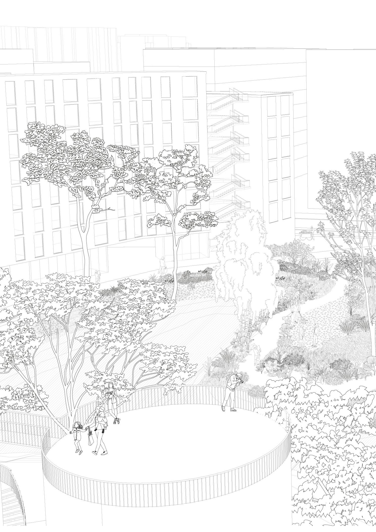
Fig 18. Possible Futures_Perspective

KILL THE WETLAND?
view of main acquifer recharge areas
Natalia Perico / Paula Ferro / Victor Mosquera / Daniel Bermudez / Miguel Steiner
Research Collaborators :

Gualí Wetland
Funza, Colombia

Once It Was a Wetland
4°42’26.0”N 74°10’54.0”W

ONCE IT WAS A WETLAND
In 1920, the “Ramada Irrigation and Drainage District” was created. A series of canals were constructed with the dual purpose of controlling flooding on the aluvial valley of the Bogotá river and increasing land value by increasing crop production.
An offset line of 30 metres around the border of the 1196-hectare Gualí Wetland was designated to protect the area. However, canals were constructed with the intention of extracting water from the wetland and receiving runoff from agricultural activities. This resulted in the wetland becoming a stagnant and contaminated body of water.
By understanding the wetland and its channels as a single body of water, the Once It Was a Wetland project aims to resdesign one of the main canals of this infrastructureo to integrate the wildlife and ecological structure of the region.
 Loremi mups
Wetland Water bodies Alluvial Valley Topography Urban footprint Ecologically Protected Areas ALLUVIAL VALLEY RAISED FIELDS TOPOGRAPHY LA RAMADA CANALS GUALÍ WETLAND WATER BODIES 0m. 500m. 1000m.
Guali
PRODUCED BY GROUP OF COLLABORATIOS
Fig.20(UP) Former alluvial valley of the Bogotá River Fig.21 (DOWN) “La Ramada” Irrigation District canal infrastructure DRAWING

Fig. 22 Regional perspective of

The project focuses on “CANAL C” to create a regional ecological connection between protected natural areas around the Bogotá region.
of protected areas and Canal C.
By redesigning the section of the canal, an ecological corridor is formed.

 Fig. 23. (LEFT) Existing canal section, floor plan, and photographic record. (GOOGLE IMAGES) Fig 24. Proposed canal section, floorplan and flora species specification.


only for human
Fig. 25 Perspective render and detailed floor
Transforming
a territory designed
needs

Towards an interconnectedness of more than human entities.
floor plan for the possible future for “C Canal”

Informal City
Prof. Sebastian Serna Juan Rey Bogotá, Colombia BetweenClouds

Between Clouds
4°38’17.3”N 74°06’18.8”W 4°31’33.4”N 74°05’27.6”W
Own phot taken in Juan Rey, a self- constructed neighborhoood in the south of Bogotá.
“EMPTY” SPACES
J uan Rey, a self-constructed neighborhood at the outskirts of Bogotá. Self-constructed at the foothills of Páramo Cruz Verde.
A self-constructed neighborhood in the foothills of a Paramo by peoples from the high plains of cundinamarca and boyacá.
Peoples from the high plains of cundinamarca and boyacá with rural backrounds.
Rural backgrounds that made the now denominated “urban” soil of Juan Rey, rural.
Rural-urban soil left “empty”, empty with chickens, crops and pathways due to its development.
How can a city grow in a rural-urban, selfconstructed neighborhood at the foothill of a Paramo?
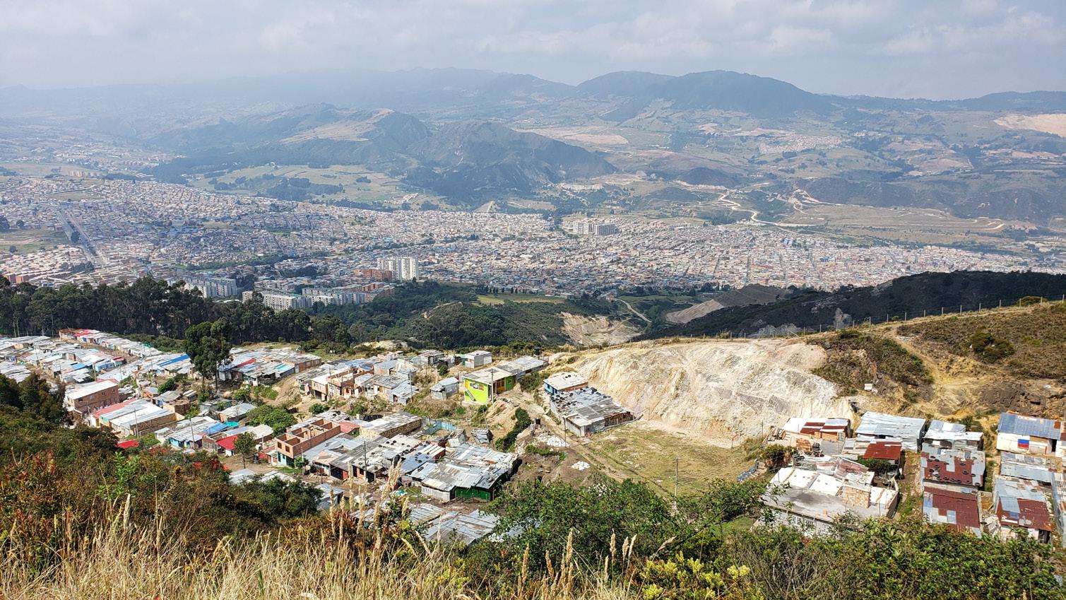
Fig 26. Own photograph portraying urban voids in Juan Rey
Self-built neighborhoods create distinctive local communities, as houses are typically constructed collectively.
What would be the implications of transferring this collective effort to a conceptualization of land ownership? Could interconnected “empty spaces” be transformed into communal spaces that would satisfy a series of existing needs?
Representation of the scale of the communal [public] space that could be created.
Fig.27 Mapping the
set of
blank -
continues non-constructed spaces bound to dissapear
Non-constructed spaces, which are typically perceived as “empty,” serve as a conduit for urban devolpment.


Yet chicken hatcheries, crops and permeable soil occupy all these spaces.


These “empty” spaces are bound to dissapear by traditional development. How can urban development be oriented towards preserving these “empty” spaces?
Fig.28 Images of non-constructed spaces

Can urban development recognize and accentuate spontanous territorial processes as autoconstrcution?
Parasitic architecture becomes a tool to seamlessly integrate existing ecologies into unbuilt spaces, challenging traditional models of land ownership. Creating communal spaces zwithin private property acknowledges the social dynamics and hidden ecological systems present in self-constructed neighbourhoods, fostering the coexistence of development and territory.
Fig. 29 Comunal Space Axonometric


Fig.
30 Digital college of comunal spaces inside the urban block
Drawing of the comunal space proposed, from a simple self-built architecture that understands the landscape it inhabits.
Timber structure allows for the growth and de-growth of the building to respond to social processes. Create
Use transparent polycarbonate sheets to provide accessibility to the dwelling and create a greenhouse effect.
Rammed earth wall acknowledges the páramo ecology, is self-buildable, and releases heat at night.
Integrate a communal greenhouse in each building to promote the agricultural identity by maintaining cultivation within the dwelling while enabling cross ventilation and heating.
Permeable ground floors respond to the new public space created in the center of the block.
Adjoin new constructions to existing gable ends, eliminating the need for demolition to increase density and build community.
MURO EN TAPIA PISADA ABSORBE CALOR DURANTE EL DÍA Y LO LIBERA DURANTE LA NOCHE INVERNADERO FOMENTA LA IDENTIDAD CAMPESINA AL MANTENER EL CULTIVO DENTRO DE LA VIVIENDA Y A LA VEZ PERMITE LA VENTILAICIÓN CRUZADA Y LA CALEFACCIÓN DE LA MISMA LÁMINA DE POLCARBONATO TRANSPAENTE ONDULADA PERMITE EL EFECTO INVERNADERO Y UN SISTEMA LIGERO CASI EFÍMERO ESTRUCTURA EN MADERA PERMITE CONSTRUCCIÓN Y DESMONTE DE LA VIVIENDA BALCONES COMUNALES EN LOS ÚLTIMOS PISOS PRIMEROS PISOS PERMEABLES Y CON DOBLE ALTURA RESPONDEN AL NUEVO CENTRO DE MANZANA LAS NUEVAS CONSTRUCCIONES SE ADOSAN A LAS CULATAS EXISTENTES, NO ES NECESARIO DEMOLER PARA CONSTRUIR CIUDAD.
communal spaces encourage community development.
Drawing of the comunal space proposed, from a simple self-built architecture that understands the landscape it inhabits.
DETALLE ESC. 1:50 PEQUEÑOS EQUIPAMIENTOS VECINALES COMO LAVANDERIAS ACTIVAN EL CENTRO DE MANZANA MEJORANDO LA CALIDAD DE VIDA DE LOS HABITANTES. PERFIL POLICARBONATO DESNIVELES EN LA TOPOGRAFÍA SON TRATADOS CÓMO OPROTUNIDAD PARA GENERAR ZONAS DE PERMANENCIA COMO GRADERÍAS VIGA MADERA LAMINADA 15X15 MACHIMBRE 9MM X 9CM DURMIENTE MADERA 4CMX4CM CÁMARA DE AIRE PARA AISLANTE ACABADO PISO MADERA 2CM VIGUETA MADERA 2X4 CADA MURO EN SISTEMA DE ENTRAMADO MADERA 2X4 AISLANTE TÉRMICO A BASE ACABADO DE MURO EL PRIMER PISO DOBLE ALTURA RESPONDE A LA CIUDAD INVERNADERO BUSCA CALENTAR LA VIVIENDA MURO TROMBE MANTIENE CALOR Y LO LIBERA EN LA NOCHE FACHADA EXTERIOR PERMITE ABRIR COMPLETAMENTE A LA CALLE ESQUINAS SE ABREN PARA EL COMERCIO, RESPONDE A DIVERSOS USOS SISTEMAA ESTRUCTURAL LIGERO EN MADERA METAL Y FACHADA EXTERIOR EN LAMINA ALVEOLAR EL PRIMER PISO DOBLE ALTURA RESPONDE A LA CIUDAD INVERNADERO BUSCA CALENTAR LA VIVIENDA MURO TROMBE MANTIENE CALOR Y LO LIBERA EN LA NOCHE EXTERIOR PERMITE ABRIR COMPLETAMENTE ESQUINAS SE ABREN PARA EL COMERCIO, RESPONDE A DIVERSOS USOS SISTEMAA ESTRUCTURAL LIGERO EN MADERA METAL Y FACHADA EXTERIOR EN LAMINA ALVEOLAR EL PRIMER PISO DOBLE ALTURA RESPONDE A LA CIUDAD INVERNADERO BUSCA CALENTAR LA VIVIENDA MURO TROMBE MANTIENE CALOR Y LO LIBERA EN LA NOCHE FACHADA EXTERIOR PERMITE ABRIR COMPLETAMENTE A LA CALLE ESQUINAS SE ABREN PARA EL COMERCIO, RESPONDE A DIVERSOS USOS EL PRIMER PISO DOBLE ALTURA RESPONDE A INVERNADERO FACHADA EXTERIOR PERMITE ABRIR COMPLETAMENTE A LA CALLE ESQUINAS SE ABREN PARA EL COMERCIO, USOS SISTEMAA ESTRUCTURAL LIGERO EXTERIOR EN LAMINA ALVEOLAR Topography as an advange to create public space Small neighborhood facilities, such as laundries, activate the center of the block and improve residents’ quality of life. on the top floors to development.
 Bogotá, Colombia
Collaborators: Victor Mosquera / Andrea Reyes / Humberto Mejia
Bogotá, Colombia
Collaborators: Victor Mosquera / Andrea Reyes / Humberto Mejia
The following projects have been developed by:

CANTERA_TALLER DE ARQUITECTURA
Design Collective
4°38’17.3”N 74°06’18.8”W


360 LAB POP UP STORE
Developed for an independent Colombian streetwear collective, the project interprets the brand’s identity and urban essence using recycled materials.
This is a demountable and transferrable project, yet not temporary. In the event of necessity, the materials can be recycled and utilized in conventional constructions.
1 2 3 4 5 6 A B 1 3 4 PLANTA PRIMER PISO 1 2 3 4 5 6 A B PLANTA TERCER PISO 1500 1500 1500 TATTOO PROBADOR PROBADOR ESCULTURA ESCULTURA 1000 2000 60° 60° 60° 60° 60° 60° 6 Pestañas para guaya equidistantes una de la otra Perfil en C 4x2cm
EN MILIMETROS
MEDIDAS
Fig. 32 Architectural Floor plan for 360 Pop-Up / Fig. 33 Detail Floor plan for hanging objects,
Collaboration with_HUMBERTO MEJIA
MIGUEL´S HOME
Apartment renovation for Miguel. The project focuses on the development of details to achieve the architectural space. The materials are mostly local and natural, with the lamp being one purchased by the client and repurposed for the project.
Collaboration with_Victor Mosquera and Andrea Reyes
LAVAVAJILLAS 450mm ESTUFA POCETA CORREDERA CIERRE LENTO 500mm CORREDERA CIERRE LENTO 500mm CORREDERA CIERRE LENTO 500mm CORREDERA CIERRE LENTO 500mm CORREDERA CIERRE LENTO 500mm CORREDERA CIERRE LENTO 500mm CAJON CUBERTERO CAJON EN "U" CORREDERA CIERRE LENTO 500mm CAJON INTERNO CORREDERA CIERRE LENTO 300mm LUZ BAJO MUEBLE perfil de incustar con aleta LUZ perfil de incustar con aleta LUZ perfil de incustar con aleta LUZ perfil de incustar con aleta LUZ perfil de incustar con aleta PUERTA DE PASO PIVOTADA CAJA FIJA CAJA FIJA CAJA FIJA ALZADO SIN PUERTAS ** RECTIFICAR ESPACIOS ANTES DE FABRICAR** ENTREPAÑO MOVIL ENTREPAÑO MOVIL ENTREPAÑO MOVIL ENTREPAÑO MOVIL ENTREPAÑO MOVIL ENTREPAÑO MOVIL ENTREPAÑO MOVIL ENTREPAÑO MOVIL ENTREPAÑO MOVIL ENTREPAÑO MOVIL ENTREPAÑO FIJO ENTREPAÑO FIJO ENTREPAÑO FIJO ENTREPAÑO FIJO ENTREPAÑO FIJO 2.285 15 2.300 100 - A PANEL TRASERO DEJARLE ESPACIO LIBRE DE 100 MM PARA CONEXIONES 876 36 600 36 36 36 342 324 15 15 15 590 15 36 3.263 36 2.277 8 2.285 15 2.300 150 9 982 9 150 2.285 36 9 15 216 15 216 15 216 15 15 15 708 15 216 15 216 15 216 15 708 15 216 15 216 15 216 15 708 15 15 15 15 15 15 15 15 15 216 15 216 15 216 15 708 15 216 15 216 15 216 15 708 620 12 15 15 800 15 270 15 15 270 15 15 800 15 270 15 270 100 273 100 15 15 800 15 870 15 870 15 15 800 15 15 870 15 15 800 15 15 870 273 100 100 273 100 900 36 300 556 15 15 15 15 850 15 15 856 12 100 30 500 36 303 36 36 303 8 2.118 9 LAVAVAJILLAS 450mm POCETA ESTUFA PREVEER ESTRUCTURA RECUBIERTA CON SUPERBOARD EN ESPACIO LIBRE PARA DAR SOPORTE A MESON PLANTA (MUEBLES BAJOS) 150 ** RECTIFICAR ESPACIOS ANTES DE FABRICAR** 9 150 36 15 880 439 2 439 1.000 CAJA FIJA 9 36 15 150 150 CAJA FIJA 68- PIVOTE 330-PIVOTE 3 928 - PUERTA PIVOTADA 3 40 4.005 - MURO FINAL 985 - VANO 36 2 297 2 898 2 898 2 898 2 300 900 900 900 300 620 298 2 617 2 15 15 150 173 9 18 15 15 850 173 18 15 BISAGRAS PARCHE PUERTAS PUSH 270 15 632 597 632 15 15 18 15 15 15 15 15 15 15 15 15 15 270 15 632 597 632 18 870 15 632 632 18 870 15 632 632 18 870 15 632 632 18 650 650 1.000 926 12 2 997 2 998 2 997 2 12 3.024 600 302 902 15 18 582 15 970 15 15 582 18 582 15 970 15 15 582 18 582 15 970 15 582 1.000 1.000 1.000 150 800 191 Fig. 33 Kitchen area details DRAWN BY: ANDREA REYES


