SPECIAL FEATURE
TRACKING Rogue vessels often operate with their Automatic Identification System switched off. When AIS is not able to supply enough knowledge, other data sources are critical for developing comprehensive maritime awareness. This is where satellite technology comes in. By Anusuya Datta
Courtesy HawkEye 360
DARK SHIPS
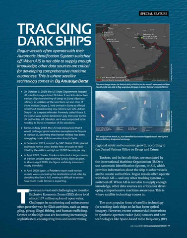
The above image shows the limited ability of AIS to track a vessel’s movement and how HawkEye 360 was able to flag suspicious AIS gaps in tanker Romina’s recorded travel
Courtesy tankertrackers.com
• On October 9, 2019, the US State Department flagged off satellite images dated October 2 and 4 to show two Iranian ships transferring oil cargo at Syria’s Baniyas refinery, in violation of the sanctions on Iran. One of them, Adrian Darya-1, had arrived in Syria to offload oil without broadcasting any notices over AIS. Adrian Darya-1 is a repeat offender. Formerly called Grace 1, the vessel was earlier detained in July that year by the UK authorities off Gibraltar, as it was suspected to be heading to Syria in violation of EU sanctions. • Earlier, in May 2019, the US had announced that it would no longer grant sanction exemptions for buyers of Iranian oil, asserting that Iranian militias had been smuggling crude oil from western Iraq to Syria.
This analysis from March 26, 2020 identified four Iranian-flagged vessels near Syria’s Baniyas Refinery designated anchorage
• In December 2019, a report by S&P Global Platts placed estimates for the cross-border flow of crude oil facilitated by the militias as high as 10,000 barrels per day.
regional safety and economic growth, according to the United Nations Office on Drugs and Crime.
• In April 2020, Tanker Trackers detected a large convoy of Iranian vessels approaching Syria’s Baniyas port. In March-April 2020, the figure suddenly increased nearly threefold. • In April 2020 again, a Reuters report said Iranian vessels were concealing the destination of oil sales by disabling the fleet’s AIS, making it difficult to assess how much crude Tehran is exporting.
T
he ocean is vast and challenging to monitor. Exclusive Economic Zones (EEZ) alone total almost 137 million sq km of open water. Challenges in monitoring and enforcement often pave the way for illicit activities, such as smuggling, piracy, illegal fishing, and human trafficking. Crimes on the high seas are becoming increasingly sophisticated, endangering lives and undermining
Tankers, and in fact all ships, are mandated by the International Maritime Organization (IMO) to use Automatic Identification System, or AIS, which provides information about the ship to other vessels and to coastal authorities. Rogue vessels often operate with their AIS — and any other tracking systems — switched off. When AIS is not able to supply enough knowledge, other data sources are critical for developing comprehensive maritime awareness. This is where satellite technology comes in. The most popular form of satellite technology for tracking dark ships so far has been optical imagery. However, recent commercial innovations in synthetic aperture radar (SAR) sensors and new technologies like Space-based radio frequency (RF) July-Aug 2020 | www.geospatialworld.net | 19