12 minute read
Tracking Dark Ships

from Road to Recovery

Rogue vessels often operate with their Automatic Identification System switched off. When AIS is not able to supply enough knowledge, other data sources are critical for developing comprehensive maritime awareness. This is where satellite technology comes in. By Anusuya Datta
On October 9, 2019, the US State Department flagged off satellite images dated October 2 and 4 to show two Iranian ships transferring oil cargo at Syria’s Baniyas refinery, in violation of the sanctions on Iran. One of them, Adrian Darya-1, had arrived in Syria to offload oil without broadcasting any notices over AIS. Adrian Darya-1 is a repeat offender. Formerly called Grace 1, the vessel was earlier detained in July that year by the UK authorities off Gibraltar, as it was suspected to be heading to Syria in violation of EU sanctions.
Earlier, in May 2019, the US had announced that it would no longer grant sanction exemptions for buyers of Iranian oil, asserting that Iranian militias had been smuggling crude oil from western Iraq to Syria.
In December 2019, a report by S&P Global Platts placed estimates for the cross-border flow of crude oil facilitated by the militias as high as 10,000 barrels per day.
• In April 2020, Tanker Trackers detected a large convoy of Iranian vessels approaching Syria’s Baniyas port.
In March-April 2020, the figure suddenly increased nearly threefold. • In April 2020 again, a Reuters report said Iranian vessels were concealing the destination of oil sales by disabling the fleet’s AIS, making it difficult to assess how much crude Tehran is exporting.
The ocean is vast and challenging to monitor. Exclusive Economic Zones (EEZ) alone total almost 137 million sq km of open water. Challenges in monitoring and enforcement often pave the way for illicit activities, such as smuggling, piracy, illegal fishing, and human trafficking. Crimes on the high seas are becoming increasingly sophisticated, endangering lives and undermining
Courtesy HawkEye 360 The above image shows the limited ability of AIS to track a vessel’s movement and how HawkEye 360 was able to flag suspicious AIS gaps in tanker Romina’s recorded travel
This analysis from March 26, 2020 identified four Iranian-flagged vessels near Syria’s Baniyas Refinery designated anchorage


regional safety and economic growth, according to the United Nations Office on Drugs and Crime.
Courtesy tankertrackers.com
Tankers, and in fact all ships, are mandated by the International Maritime Organization (IMO) to use Automatic Identification System, or AIS, which provides information about the ship to other vessels and to coastal authorities. Rogue vessels often operate with their AIS — and any other tracking systems — switched off. When AIS is not able to supply enough knowledge, other data sources are critical for developing comprehensive maritime awareness. This is where satellite technology comes in.
The most popular form of satellite technology for tracking dark ships so far has been optical imagery. However, recent commercial innovations in synthetic aperture radar (SAR) sensors and new technologies like Space-based radio frequency (RF)
Courtesy HawkEye 360


This vessel displays a poor AIS record, with many gaps, as the vessel left port from Malaysia traveling west. HawkEye’s satellites identified VHF Channel 70 communications from the vessel as it was passing near the Riau Islands. This provided information about the ship’s chosen travel path through the Riau Islands, as opposed to a more southernly route, which could be meaningful, depending on the context
This representative display shows how little AIS data is available in the South China Sea. Multiple passes of HawkEye 360’s satellites reveal significantly more vessel activity by geolocating X-band marine navigation radar signals
mapping have added new dimensions to maritime monitoring.
“Governments and maritime insurers rely on AIS as vital means for monitoring the oceans, but AIS has severe limitations. Ships engaged in illicit activities can deactivate their AIS beacons, vanishing off the map. Other problems include malfunctioning equipment or congestion interference that prevents receiving the vessel geolocation,” explains John Serafini, CEO, HawKeye, a smallsat company which has pioneered RF Remote Sensing.
Other alternatives for monitoring, such as patrolling with coast guard vessels or airplanes,
are resource intensive. RF mapping: Wavelength matters Somewhere in middle of March 2020, HawkEye 360 started monitoring Iranian crude tankers that might be traveling to Syria. One such vessel, Romina, was last known to have returned to Iranian waters from a trip on February 23. Romina then remained completely dark until it appeared in the Gulf of Suez on March 17. HawkEye’s SEAker tool flagged suspicious AIS gaps in the vessel’s recorded travel. When the vessel exited the Suez into the Mediterranean on March 21, it again went dark.
On the evening of March 25, HawkEye 360 geolocated VHF Channel 16 maritime signals at Syria’s Baniyas Refinery. VHF Channel 16 is the international hailing frequency to establish initial contact between two vessels or a vessel and land. For navigation and communication purposes, ships need to switch on their VHF signals from time to time. While AIS records showed no vessels in the vicinity at this time, the detected VHF signal poten
GOING DARK
All ships are required to carry Automatic Identification Systems (AISs) capable of providing their information to other ships and to coastal authorities automatically, as per a mandate by the International Maritime Organization effective December 31, 2004. The regulation requires AIS to be fitted aboard all ships of 300 gross tonnage and upwards engaged on international voyages, cargo ships of 500 gross tonnage and upwards not engaged on international voyages and all passenger ships irrespective of size. The ships are required to keep the AIS in operation at all times except where international agreements provide for the protection of navigational information. But not all cases of AIS signal blockage are intentional as weak signals, spotty satellite reception and interference can cause gaps in AIS tracks.
tially indicated newly arriving tankers that were coordinating the offloading of crude oil. But this required more information to validate.
On March 26, 2020, Tanker Trackers analyzed Planet’s 3-meter electro-optical satellite imagery of the sea near the Baniyas Refinery to find several vessels near the designated anchorage. It used its library of 3-meter imagery signatures for the Iranian crude-carrying fleet and associated assets to identify four Iranian-flagged vessels (Romina, Samah, Adrian Darya-1, and Tour-2). Although Adrian Darya-1 was already known to be at the port, the arrival of Romina and additional tankers to Syria’s Baniyas Refinery without AIS notification was consistent with the behavior anticipated from vessels being used to evade sanctions.
This fusion of multiple commercial modalities — geolocated RF signals combined with satellite imagery analysis — produced an unclassified and shareable assessment that could be used by authorities for effective maritime monitoring. This also opens up future opportunities for identifying maritime activity of interest for further investigation, allowing enforcement organizations to deploy resources accordingly.
“The fusion of HawkEye 360’s data with Tanker Trackers’ imagery intelligence (IMINT) and open source intelligence (OSINT) resulted in a first-of-itskind unclassified and shareable assessment of Iranian tanker activities,” says Serafini, whose company has been involved in filling maritime vessel information gaps even in the normal course of events when signaling is bad.
“The HawkEye constellation is able to geolocate a diverse set of RF signals emitted by ships such as marine radar, VHF radio, satellite communications, and emergency beacons. This broader RF range expands visibility to help locate dark ships and identify anomalous behavior,” Serafini adds.
Seeing through the darkness with SAR In March 2020, a report revealed an unprecedented number of vessels at North Korea’s main ports, in what could be interpreted as Pyongyang ordering its ships, which otherwise are engaged in illicitly ferrying cargo to China, back home in the aftermath of the COVID-19 outbreak.
Project Sandstone, an initiative by the Royal United Services Institute (RUSI) — the world’s oldest and the UK’s leading defense and security think tank — used SAR and optical satellite imagery analysis taken across February and March to show over a hundred motionless vessels anchored in the same areas. This is an unprecedented phenomenon in North Korea’s otherwise bustling port area of Nampo. Project Sandstone had earlier revealed that North Korean cargo ships were continuing to deliver coal to China in violation of the UN Security Council resolutions.
Analysis of ESA’s Sentinel 1 SAR imagery shows North Korean vessels returning home in increasing numbers during February–March 2020 period
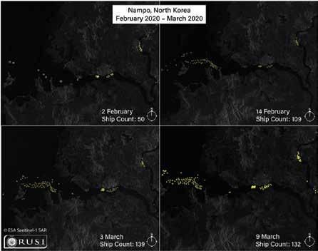
Courtesy: European Space Agency
INTERNATIONAL TRADE AND SANCTIONS
International trade, sanctions and regulations are complex and ever-changing, and in certain aspects include different requirements, thresholds for violations and consequences of breach. For instance, as Samir Madani, Co-Founder of Tanker Trackers, points out: “Iranian oil exports are not illegal. They would only be deemed so if they violated international resolutions such as UN sanctions, which is the case for North Korea, where there are strict quotas on what they are allowed to import and export. Both Iran and Venezuela are under unilateral US sanctions, and that means that international buyers of their oils are subject to the sanctions by US.” It is the buyers that risk being excluded from the US market, USD transfers and IBAN banking system. Since the US government has informed maritime ports that they will face penalties if they are seen helping Iranian or Venezuelan oil transfers in any way, buyers may hesitate to be part of such deals.
SAR satellites use radio waves to image the Earth’s surface. Ships have a large radar cross section, making it easier for SAR sensors to detect them quickly, even when they turn off their AIS beacons. And because radar can penetrate through clouds and darkness, they can capture images on the Earth regardless of light or weather conditions. Analysts then use Machine Learning algorithms to combine AIS and radar data, and sometimes electro-optical or hyperspectral images to draw information about ships.
For instance, ICEYE, a pioneer in small SAR satellite technology, partnered with Spire, the world’s largest Space-to-Cloud analytics company, in 2019 to track illegal fishing activities in the Exclusive Economic Zone of Argentina. There have been incidents where the Argentine Coast Guard has had to take reactive actions against illegal vessels. Finland-based ICEYE claims to have the world’s largest radar satellite constellation with fastest coverage.
In another case, this time in the Middle East, ICEYE images showed a dark vessel moored near the UAE Port of Fujairah, where four commercial vessels were damaged in May following what was described as “sabotage attacks” by UAE authorities. While the vessel was officially classified as a tanker, high-resolution images from ICEYE’s SAR satellites showed two tankers in a ship-to-ship transfer formation — often an indicator of illegal trans-shipments, such as the unreported transfer of petroleum from one vessel to another — as well as a supportive tugboat to the side of one of the vessels.
The region had seized global attention last year after two oil tankers were attacked when passing by the Strait of Hormuz — a key oil chokepoint. This immediately stoked tensions between the US and Iran, resulting in a 3% jump in oil prices.
“Our Dark Vessel Detection is built for governments around the world for improving the maritime safety of their regions, enabling authorities to take action based on reliable information. Data users can improve their enforcement activities against illegal trans-shipments of goods, help them in addressing illegal fishing, and assist in
In the ICEYE-X2 SAR image above, there are Chinese squid fishing vessels that have their AIS tracking turned on, while other vessels have their AIS off

Courtesy: ICEYE

This visual from ICEYE-Spire analysis show a dark vessel moored near the UAE Port of Fujairah
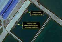
Courtesy: Planet; 38 North Courtesy: Airbus; 38 North Left: Overview of secure boat basin; the Sinpo-class submarine, submersible barge and midget submarine are visible at the secure boat basin on January 1, 2020. Center: SAR image of the secure boat basin. Right: Layover and foreshortening examples in SAR imagery of Sinpo. Below: Two pictures show strong layover effect in SAR imagery of test stand at Sinpo


Courtesy: Airbus; 38 North
Courtesy: Planet; 38 North

curbing drug and human trafficking,” says Steve Young, Vice President, Business Development and Sales, ICEYE.
Optical imagery is still at the core What is making these new technologies more desirable is the magic that happens when this data is fused with optical images. As we saw with the analysis by HawkEye 360, it was only after overlaying the mapping of RF data on the electro-optical imagery by Planet that one could get an idea of the situation on ground.
Similarly, another example from North Korea about its submarine activities demonstrates the use of SAR to augment electro-optical (EO) multispectral and panchromatic satellite imagery. In January 2020, 38 North, a US-based expert think tank on North Korean affairs, analyzed SAR imagery to reveal the presence of the North Korean experimental ballistic missile submarine and its submersible test stand barge positioned beneath a dockside awning, constructed barely four months back designed to conceal and environmentally protect these vessels at its SINPO Naval base.
Oil’s not well The downside for these evolving technologies is that they are expensive and limited. It may take several days to access the data, and global coverage is not available on a daily basis. While these technologies have been available with most naval security agencies, it is only now that they are commercially available, making them lucrative for some businesses. For instance, commodity companies, oil & gas in particular, would be extremely interested, since they may want to make sure that links to their operations are not breaking sanctions, or ship-toship transfers are not happening on their vessels. Crude exporting
Courtesy: Airbus; 38 North

countries have their fixed quota for transfers under the trade norms, and any violation can potentially cause volatility in the international oil prices. Tracking the location of all commodities and the estimated time of their arrival at a particular destination allows traders to be dramatically more accurate in predicting daily prices in different parts of the world.
There may be some very legitimate reasons for an AIS signal to “go dark” — regions deemed unsafe owing to piracy or genuine signal loss. However, as Gard, a top marine insurer, observers: “Going ‘dark’ in areas of heightened surveillance is a red flag to authorities and legitimate reasons may need to be evidenced to dispel suspicion of intentional avoidance of sanctions compliance.”
Anusuya Datta
Editor-At-Large Technology & Innovation anusuya@geospatialmedia.net