9 minute read
Sponsored article by Teledyne Caris


How the S-100 Service Enables Safe and Optimized e-Navigation
Unlocking the Potential of Marine Geospatial Data
The Canadian Hydrographic Service (CHS), Teledyne CARIS (CARIS) and ECC/PRIMAR (PRIMAR) are partnering on a pilot project to implement an innovative data service to deliver S-100 products. The service will initially focus on S-102 bathymetric surface and S-111 surface current products and will grow to support additional S-100 products as the system enters operational service.
The S-100 service is subscription-based, taking a modern, web-services approach to product delivery. This service-oriented approach aligns with IMO’s Maritime Service Portfolio (MSP) and e-navigation principles, while leveraging the existing IHO Regional ENC Coordinating Centre (RENC) distribution network. We spoke to Louis Maltais, director of Navigation Geospatial Services and Support; Karen Cove, senior product manager at Teledyne CARIS; and Hans Christoffer Lauritzen, director of PRIMAR, for their insights on exactly what value this project will offer the field.
Robust paRtneRship
This team has taken on an ambitious challenge, carving a path through the unknown and achieving a solution to bring to market, with CHS, CARIS and PRIMAR each contributing expertise. Maltais explains that the CHS represents Canada’s hydrographic interests on the bodies that develop and oversee hydrographic and chart information standards and is a world leader in hydrography. For this project, CHS is the S-100 producer, and therefore in charge of several layers. For example, CHS publishes paper current atlases and has a mandate to lead and develop these layers within the digital context, as well as to receive and maintain data. PRIMAR is a non-profit, international collaboration dedicated to providing a consistent and reliable electronic navigational chart (ENC) service, and playing a leading role in providing the best navigational solutions for the world’s merchant fleet, navies, marine pilots and government agencies. On this project, PRIMAR collects S-100 data from several hydrographic offices, validates the data and makes the data available for distribution, functioning as a one-stop shop for S-100 data. It manages the business part and revenue stream on behalf of the hydrographic offices. CARIS is the trusted technology provider for chart production and other hydrographic workflows, products and services at most hydrographic offices around the world. This put CARIS in a unique position as these hydrographic offices and the hydro community at large pivots to this new era of products and services underpinned by the S-100 standards framework, meeting the need to be prepared for e-navigation and autonomous shipping. Here, CARIS has
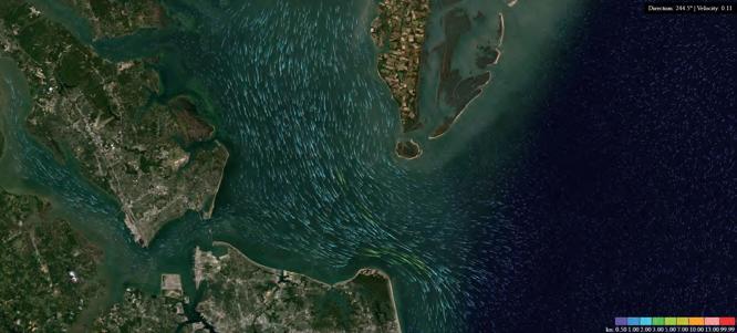
Potential use of innovative S-111 Portrayal for blue economy services, S-111 source data provided by NOAA.
taken the opportunity to leverage its research and development efforts to build cutting-edge cloud architecture that can support the marine community in this important transition. The S-100 CARIS Cloud provides the back-end infrastructure to move data from the CHS production environment into the distribution network. CARIS has purpose-built a technology stack to take advantage of cloud infrastructure in terms of scalability, security and access to provide optimal solutions for hydrospatial workflows and data distribution. Key to this are cloud services to facilitate access to software, the efficient management of data holdings within the service, providing cloud-native processing capability, and a robust security model.
seRvice-oRiented appRoach
The service approach has been well established for many years concerning the distribution of ENCs, so it made sense to take a service-oriented approach using subscription-based pricing models when establishing the S-100 service. This services approach allows for data to move through the value chain to the consumer efficiently and with full assurance of data integrity and security. OGC Web Services offer the benefit of minimal data duplication and a streamlined workflow that facilitates the quick turnaround of data from survey-tobridge, allowing for fully standardized access to data as required by the users of the S-100 service. Using a real-time service approach means that data is always up to date, and that users are able to access data much more rapidly. The quality of the S-100 outcome is the result of strong communication, agile problem solving and a spirit of innovation, which all three experts agree has been a positive experience. CHS, CARIS and PRIMAR have worked constructively together throughout, contributing their strengths and valuing each other’s competences and perspectives. As Lauritzen observes, this has led to optimization of the S-100 service.
hydRogRaphic offices
S-100 opens up myriad opportunities for both the marine transportation industry and for hydrographic offices. Cove explains that the S-100 service revolutionizes the possibilities for data products and value-added services to be made available for navigation, making strides in terms of sensor-to-bridge turnaround time. The latest and best data, in some cases potentially near real time, will be collected on a continuous basis, and can then be pushed out to pilots and other end-users via a subscribed service. Both Lauritzen and Maltais note the improved safety of navigation and optimization without increasing risk. For example, the more exact calculation of under keel clearance and more economical navigation will be possible, since exact depth, current and tidal information gives the opportunity to optimize cargo load and enhance the timing of port entrance. With this quality of data, ships can leverage surface currents in the right direction or adjust their route, optimizing transit and reducing the carbon footprint. For hydrographic offices, S-100 will function as an enabler to respond to that interest with relevant products and services that are based on an interoperable standards framework, allowing data to be used by many people in many ways. Lauritzen notes the potential opportunities to produce official datasets that have high value for end-users, leading to new possibilities for increased revenue. S-100 will indeed allow hydrographic offices to be agile and responsive to stakeholders as their needs evolve, and new kinds of stakeholders beyond the realm of navigation become more aware of
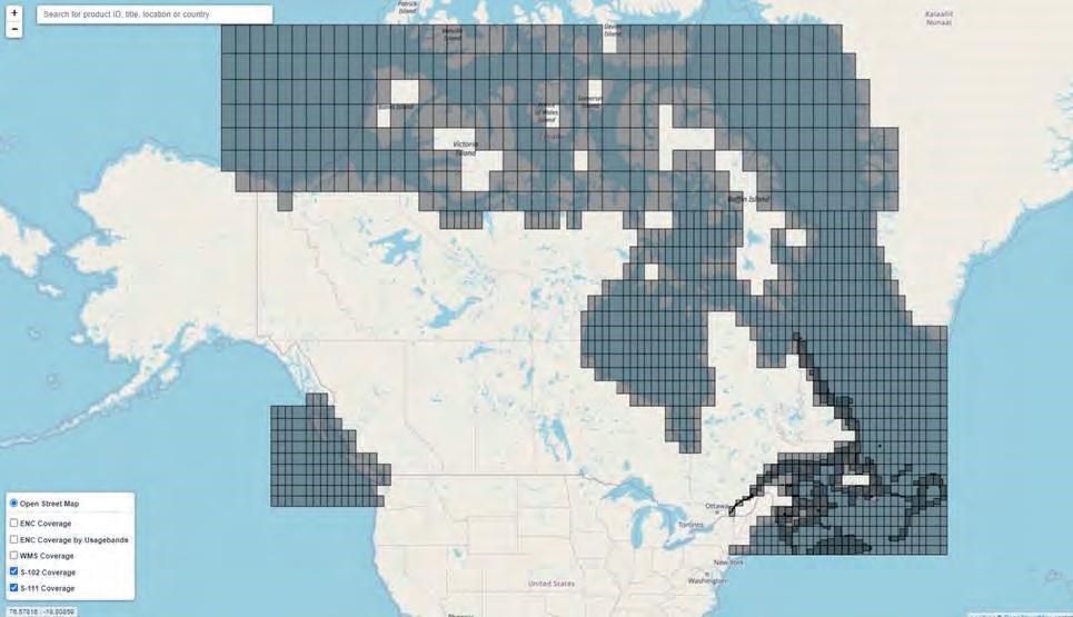
Current coverage of Canadian S-102 and S-111 in the PRIMAR Chart Catalogue.
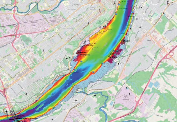
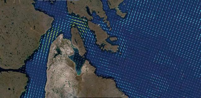
Picture from the PRIMAR web viewer showing Canadian S-102 data in combination with ENCs.
hydrographic and marine data of all sorts, says Cove. Maltais adds that the S-100 framework could enable databases to be disseminated in a seamless way. This can provide a picture of what the end state could look like regarding metadata and data organization, assisting those operating within a national setting to determine what data items they may need to feed over the next few years, helping to identify and fine-tune key items for inclusion in their database design.
s-100 pRoduct development
Feedback from end-users is absolutely a critical factor in the development of S-100 products and the success of the S-100 service, states Cove. The entire pipeline must be in place and working for the end-user to reap the benefits, plus the voice of the end-user needs to filter right up the value chain. She explains that the user trials organized by the CHS are an important check that what is being developed is effective and brings value to the intended end-user. The CHS is interested in obtaining early user feedback so that it, as technology partner, can move forward the development of tools informed by the end-users. In this case, CHS recognized that they needed to build interest and capacity along the entire chain. What we have found in this project is real engagement with pilots who see the benefits of having these products and services available to enhance how they do their jobs. Maltais adds that S-102 has improved their knowledge of their environment – an exciting development in terms of unlocking the potential and delivering it to clients. This has created a real feedback loop driving back through the chain to the hydrographic office, and even beyond into the IHO working groups, where the S-100 framework and product specifications are developed.
new eRa in digital data
The impact on traditional static products and how they are produced is likely to be that they gradually diminish. The value that digital, data-centric software products offer to the field, in relation to automated compilation and validation, is continuing to transform the systems and workflows of the hydrographic office. Cove is excited to see how the world of navigation and marine GIS more broadly will continue to transform over the coming years. She thinks it is an opportunity to be at the bleeding edge, observing how emerging data products defined under the S-100 standards framework will be used in practice. In turn, we will be able to see what those end-users will then demand of hydrographic offices, other data providers and solution vendors in terms of even more new products and services. Cove agrees that this is an exciting time for the hydrographic community, with new influences, new interest from the wider public, new technology available, and a new mindset about what it means to be a hydrographic data provider. She goes on to explain that the value of bathymetry and hydrographic data more generally is being recognized, demonstrated in part by the investment in Canada’s Oceans Protection Plan, through the GEBCO Seabed 2030 initiative to map the world’s seafloor and through the UN’s designation of the next decade being focused on the oceans. Lauritzen considers this project a perfect fit in the future digital ecosystem, since it allows for a more precise digital model of the real world. All those with a stake in marine navigation should be watching this project, since the S-100 service has the potential to increase both the safety and efficiency of navigation, and in particular hydrographic offices should be engaging since they are responsible for producing the S-100 data, thinks Lauritzen. Cove adds that a sizeable segment of the ocean sector will be able to benefit from having high-quality, highresolution and timely marine data readily available to use in a wide variety of applications. She believes the coming years will be driven by innovation all the way through the maritime value chain, from data collector to data provider through to end-user. The S-100 framework and the S-100 service are indeed well positioned to support and contribute to this dynamic future.
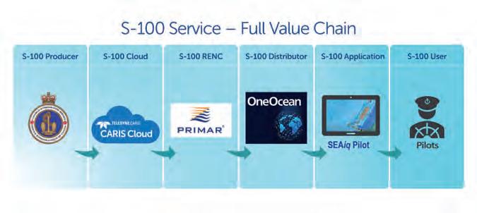
Diagram outlining the S-100 value chain.
Connect with our Experts Hans Christoffer Lauritzen
Hans Christoffer Lauritzen graduated from the Royal Norwegian Naval Academy in 1990. He served on board various Norwegian submarines, including as CO of Kobben and Ula class submarines. He left the Navy in 2006 to start work in a shipowners company. After completing a Master’s degree from the Norwegian Business School, he joined the Norwegian Hydrographic Service as director of PRIMAR in 2012. hans.christoffer.lauritzen@kartverket.no
Karen Cove
Karen Cove is senior product manager at Teledyne CARIS. Since receiving her MSc Eng in Geodesy and Geomatics (UNB), Karen has enjoyed a career in marine geospatial. Before joining CARIS, Karen worked with Fisheries and Oceans Canada and has a keen interest in mapping to support the safe and sustainable use of the ocean and coastal environments. karen.cove@teledyne.com
Louis Maltais
Louis Maltais is director of Navigation Geospatial Services at Canadian Hydrographic Service. He was highly involved in drafting S-102, S-111 and S-104 IHO product specifications and now leads the delivery of S-100 Hydrographic Dynamic Services contributing to e-navigation in Canada. Louis is the chair of Canada’s S-100 interdepartmental committee. louis.maltais@dfo-mpo.gc.ca