5 minute read
Sponsored article by Hypack

Complete Lidar Surveying Solution for Aerial and Marine Topographic Surveys!
The HYPACK LiDAR Payload is an end-to-end solution suited for use on boats, drones or terrestrial vehicles. Land or water, this solution is designed to meet your topo Lidar surveying needs quickly and easily.
The surveying and mapping sector perpetually pushes for innovation. In today’s professional climate, resources are thin. Companies or agencies must accomplish surveys with minimal staff while maintaining safe public health practices. Tools that increase workplace efficiency and reduce operating costs are more vital than ever. HYPACK has risen to the occasion with the HYPACK LiDAR Payload. The payload is a stand-alone, cost-effective Lidar surveying solution that features a VLP 16 Puck Lite Lidar sensor, an SBG Ellipse 2D INS/GNSS, HYPACK Max/ HYSWEEP, and a Pico 500 mini PC. The sensors are enclosed within an IP67 rated unit suited to withstand inclement weather for marine surveying or field work in rugged environments. The unit is self-powered through a battery insert and boasts a three-hour run time. The power autonomy of the payload is an advantage for UAV users because it provides increased run time and mission efficiency.
The payload is delivered in a ruggedized Pelican case for ease of transport. Inside the case, there is a charging system for the unit, standardized documentation, and two mounting systems. The first mounting system features UAV mounting clamps that attach to the DJI Matrice line. The mounting clips are drone agnostic, meaning they are designed to attach to industry-standard attachment rods so that they can pair with the UAV of your choice. The second mounting system is a U-shaped bracket that attaches to the outer enclosure of the unit. The bottom portion of the U-shaped bracket is flat and can easily attach to a moving vehicle.
Good Lidar data depends on accurate and reliable GNSS data. The HYPACK LiDAR Payload addresses this in a few different ways. First, the system’s antennas extend to a set distance of one metre, effectively reducing the need for repeat heading calibrations. The antenna arms are held in place by specialized links that prevent movement while the unit is in motion. For easy transport in a Pelican case, the arms then retract into place and rest against the unit enclosure.
The payload can support RTK corrections and collection of GNSS data to produce a PPK solution. To broadcast RTK data into the unit, you can leverage the USB port on the back of the payload to establish a Wi-Fi connection. One simple way in which HYPACK has created a Wi-Fi connection with the unit is by ‘tethering’ a mobile phone to the payload. First, HYPACK uses the Ethernet port to create a remote desktop connection with our testing laptop to initialize the appropriate software programmes. Then, a mobile phone is plugged into the available USB port to allow the connection on the phone. Once a Wi-Fi connection is established, an NTRIP subscription and broadcasting software are required. Many state and local governments operate are required free RTK/NTRIP networks. HYPACK uses NTRIP software called Lefebure. When Lefebure has established a connection to the server, it broadcasts RTK data to HYPACK SURVEY
Figure 1: The HYPACK LiDAR Payload with extended antenna arms.
and HYSWEEP during data acquisition. Data acquisition software runs on the payload for raw GNSS data; SBETS can be post-processed in the SBG Qinertia software. This solution is capable of producing data with PPK accuracy within three centimetres.
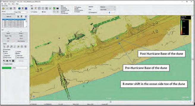
While the payload was designed with UAVs in mind, the autonomous nature of the tool supports multi-environment use. After Hurricane Isaias brushed the shores of South Carolina in early August of 2020, a Coastal Carolina University (CCU) research group led by Director Paul Gayes used the HYPACK LiDAR Payload to survey the extent of the environmental damage caused by the storm. Gayes and his research group at CCU used the HYPACK LiDAR Payload as a tool to educate their community about the environmental effects of major storm cycles and improve the resilience of the coastal community. Gayes has studied the dunes of Myrtle Beach for about three decades. His group uses Lidar to quantitatively analyse beach erosion rates, volumes and movement patterns. These beach erosion surveys ultimately help to inform local officials on the erosion patterns of the dunes, guiding their planning decisions in the face of natural disasters and for beach renourishment projects. Gayes and his research team attached the payload to a stable beam attached to a four-wheeler to analyse dune erosion caused by the storm (Figure 2). The team used a local RTK network and processed pre- and poststorm data in a HYPACK multibeam editor. After a preliminary analysis, the data showed an eight-metre landward shift of the dunes (Figure 3). The HYPACK LiDAR Payload is an effective tool for beach erosion surveys, with numerous other applications, including shoreline/obstruction charting for navigation, pipeline mapping, infrastructure assessments, vegetation surveys, bare earth analysis, corridor mapping, defense and military applications, and more. HYPACK is working on several exciting partnerships to bolster its Lidar processing tools and to expand your surveying capabilities. The HYPACK Payload is a cost-effective, versatile solution that will meet and exceed your project needs. Please contact HYPACK, a Xylem Brand, for questions or additional information about this system.
Figure 3: Contour data derived from Lidar XYZ data; the contours show an eight-metre landward shift, or net loss, of the dunes.
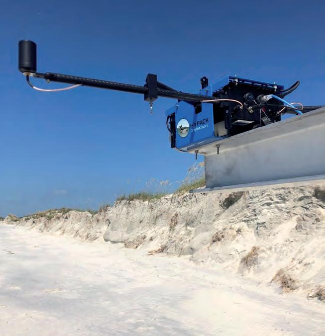
Figure 2: HYPACK LiDAR Payload attached to four-wheeler for beach renourishment surveys.
Webinar
HYPACK, a Xylem Brand 56 Bradley Street Middletown, CT 06457, USA Phone: 1-860-635-1500 Email: sales@hypack.com Website: hypack.com
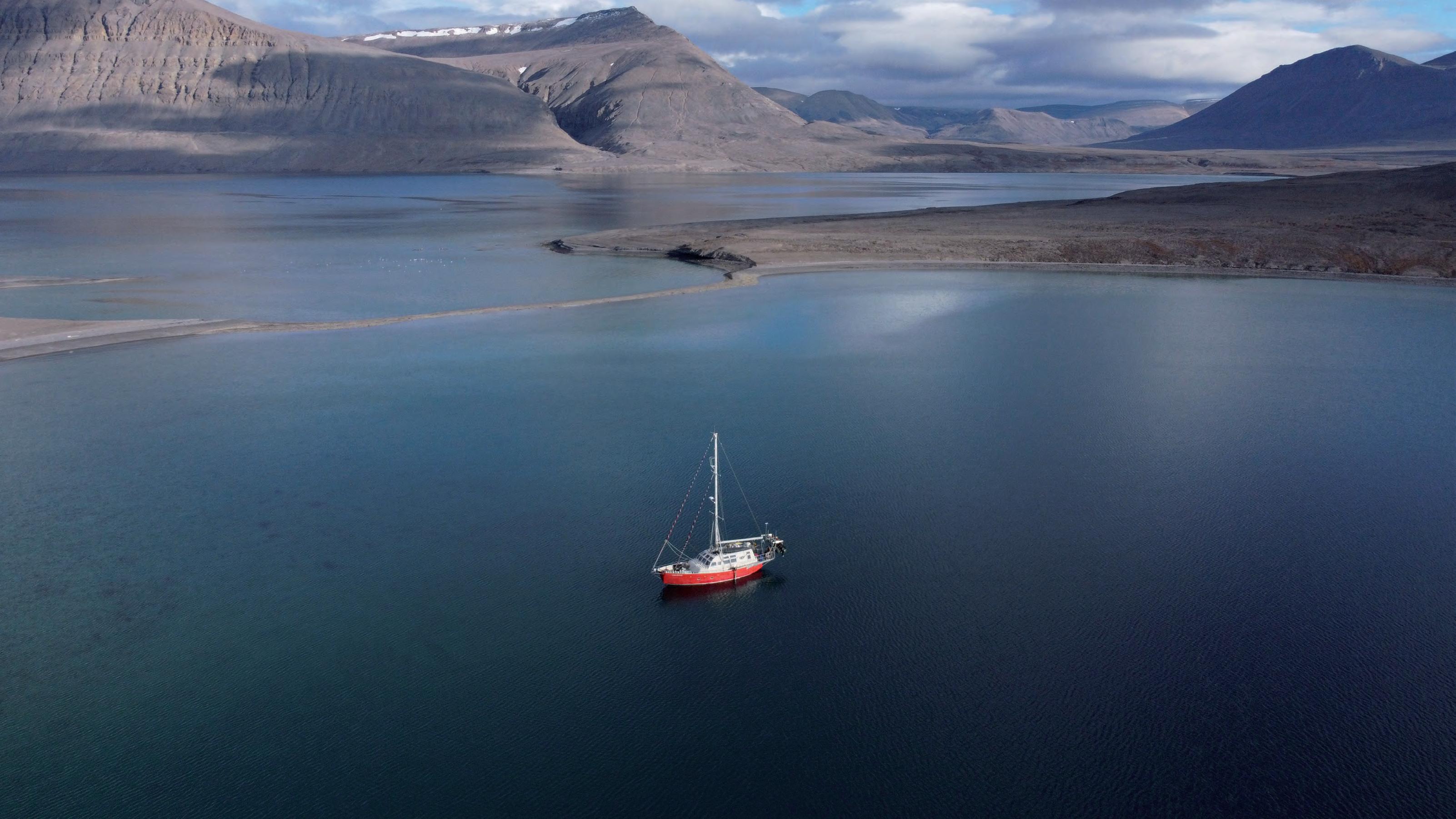
SURVEYING BY SAILBOAT: BATHYMETRIC MAPPING OF THE CANADIAN HIGH ARCTIC

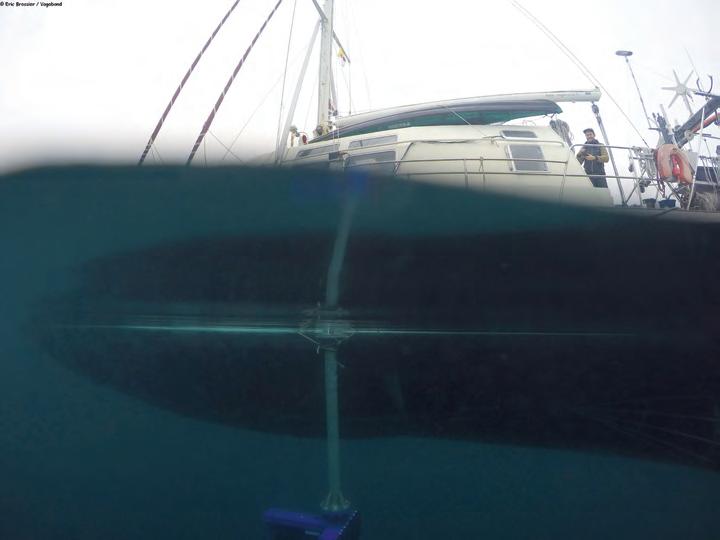
There is a big need to develop new cost-effective mapping programmes in the Canadian High Arctic to improve data coverage, particularly in the shallow uncharted near-shore areas that larger vessels with deep draft are unable to access. This photo displays the Vagabond sailboat with the pole mount installed on the side, with Arctic landscapes around. The Vagabond is an expedition yacht designed for sailing in ice. The insert shows a photo taken by captain Eric Brossier last year in which we can see the sonar in the water.
The bathymetric survey was deployed in the summer of 2019 to acquire nearly 300nm of multibeam echosounder data and 500nm of single beam echosounder data from the 47ft. (14m) polar sailboat Vagabond. The datasets were collected between the eastern coast of Ellesmere Island and northern coast of Baffi n Island, and surveys targeted uncharted near-shore regions of the continental shelf, glacial fjords, and gaps in existing coverage.