Business Guide 2023 MARKET ANALYSIS | COMPANY PROFILES | INTERVIEWS | INDUSTRY INSIGHTS Map the Gaps: Connecting People and Oceans Perspectives: Talking About Hydrographic Revolutions Industry Survey: New Technology and Energy Transition


situational
nortekgroup.com
Pioneering vessel-mounted current measurement for improved
awareness
Hydro International is an independent international magazine published six times a year by Geomares.The magazine and related e-newsletter inform worldwide professional,industrial and governmental readers of the latest news and developments in the hydrographic,surveying,marine cartographic and geomatics world.Hydro International encompasses all aspects,activities and equipment related to the acquisition,processing,presentation,control and management of hydrographic and surveying-related activities.
P. 8 New Horizons for Hydrography, but Who Will Conquer Them?
Every year, Hydro International surveys the state of the hydrographic industry to gain a comprehensive understanding of the sector and the challenges it faces. The survey includes a series of multiple-choice questions, but also questions that allow for detailed, open-ended responses, giving us a wealth of information to analyse. After carefully reviewing and evaluating the survey results, we present our findings in this article.
P. 15 Map the Gaps: Connecting People and Oceans
Geomares P.O. Box 112, 8530 AC Lemmer, The Netherlands Phone: +31 (0) 514 56 18 54
E-mail: info@geomares.nl Website: www.geomares-marketing.com
No material may be reproduced in whole or in part without written permission from Geomares. Copyright © 2022, Geomares, The Netherlands All rights reserved. ISSN 1385-4569
Director Strategy & Business Development: Durk Haarsma
Financial Director: Meine van der Bijl
Editorial Board: Huibert-Jan Lekkerkerk, Mark Pronk, BSc, Marck Smit, Auke van der Werf
Head of Content: Wim van Wegen
Copy Editors: Serena Lyon

Marketing Advisor: Myrthe van der Schuit
Circulation Manager: Adrian Holland
Design: ZeeDesign, Witmarsum, www.zeedesign.nl
Business Development Manager: Jurjen Visser
Advertisements

Information about advertising and deadlines are available in the Media Planner. For more information please contact our business development manager (jurjen.visser@geomares.nl) or go to www.geomares-marketing.com.
Subscription
Hydro International is available on a subscription basis. You can subscribe at any time via https://www.hydro-international.com/subscribe. Subscriptions will be automatically renewed upon expiry, unless Geomares receives written notification of cancellation at least 60 days before the expiry date.
Editorial Contributions
All material submitted to the publisher (Geomares) and relating to Hydro International will be treated as unconditionally assigned for publication under copyright subject to the Editor’s unrestricted right to edit and offer editorial comment. Geomares assumes no responsibility for unsolicited material or for the accuracy of information thus received. In addition, Geomares assumes no obligation for return postage of material if not explicitly requested. Contributions must be sent to the head of content wim.van.wegen@geomares.nl.
Map the Gaps is cultivating and empowering a growing network of professionals, organizations and communities working together to create new ways for interacting with, understanding and protecting the seafloor. The movement helps to increase diversity, equity and inclusion in the ocean mapping community and provide access to discovery expeditions and leading technology. Map the Gaps’ vision is to promote discovery, knowledge and connection to the oceans and coastal communities by enabling and empowering a diverse global network of relevant professionals.
P. 21 Towards Affordable High-end Solutions to Direct ROVs
Taking into account the increasing demand for autonomy in hydrography, this article examines the development of an innovative, small-sized subsea sensor fusion solution. This groundbreaking solution has the potential to automate ROV underwater monitoring and inspection tasks, at a cost of less than €10,000. This article delves into the results of the developed solution, as well as the initial validation tests to assess its performance. Furthermore, it outlines the next steps to further improve on the capability.
P. 27 A Classification of Survey Platforms

The life of a hydrographic planner used to be easy: you had a survey vessel from which (at least in nautical cartography) you deployed a number of survey boats (often sloops) with a simple sensor suite. However, the growth in different types of survey platforms (and sensors) and their accompanying abbreviations in recent decades necessitates some form of classification. While there are as many classification systems as people with imagination, in this article I present a system that I find usable in the surveying business.
P. 31 The Case for Hydrographic Survey Vessels in Uncrewed Vessel Operations
The state of the art in autonomous surface vehicles has evolved tremendously over the past few years, and these technologies will revolutionise the field of hydrography. However, experience shows that developing these systems to their full capabilities while fulfilling hydrographic needs will continue to require the support of capable hydrographic ships.
P.
Cover Story
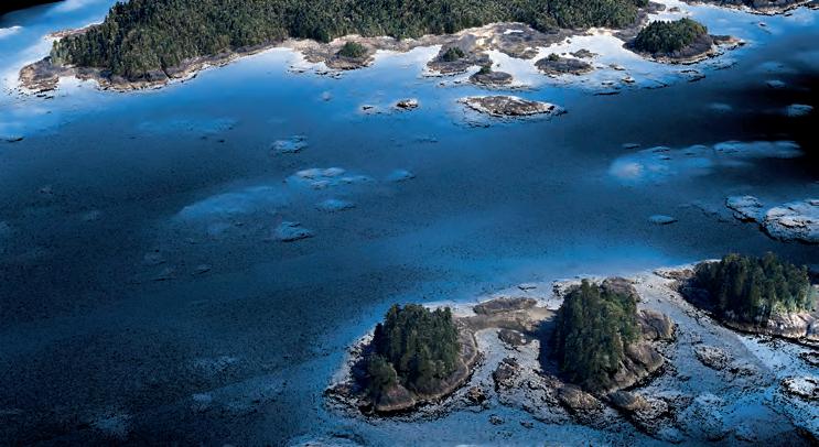
The annual Hydro International Business Guide can best be described as a reference work for hydrographic professionals around the world. The articles and interviews in this 2023 edition of the Business Guide offer an overview of the current state of the industry from a slightly more reflective angle. What are the relevant trends and developments in hydrography, and in which directions is the business heading? (Image courtesy: GEOxyz)
Hydro INTERNATIONAL | BUSINESS GUIDE 2023 | 3 CONTENTS P. 5 Editorial P. 6 Perspectives Business Guide 2023 MARKET ANALYSIS COMPANY PROFILES INTERVIEWS INDUSTRY INSIGHTS Map the Gaps: Connecting People and Oceans Perspectives: Talking About Hydrographic Revolutions Industry Survey: New Technology and Energy Transition
19, 37, 41, 43 5 Questions to… P. 44 Company Profiles P. 53 Interview
© 2022 Teledyne CARIS and Teledyne Optech, are both Teledyne Technologies companies. All rights reserved. Specifications are subject to change.
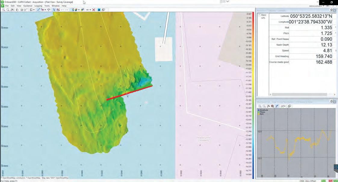
Teledyne Geospatial Imaging Solutions for Land and Water THE EVOLUTION OF CARIS ONBOARD HAS ARRIVE D CARIS COLLECT FEATURING • CARIS Collect module for sonar and lidar acquisition • Seamless integration into survey operations • Complete Ping-to-Chart workflow solution Available as a perpetual or SaaS annual license CARIS Collect brings the most cost-effective acquisition software package to market. FOR MORE INFORMATION:
COLLECT WITH CONFIDENCE
www.teledynegeospatial.com/cariscollect
Predictions
As I write this editorial, preparations for Hydro 22 are in full swing, which makes the writing quite tricky from a grammatical perspective. Only a few more days and we will see/have seen each other again, at the first hydrographic exhibit or conference in a long time that does not mention COVID-19 or preventative measures. Of course, we saw each other at Hydro business and Oceanology International, but it will be nice this time not to have to worry about travel arrangements and other issues.
COVID-19 has shown us how difficult it is to predict the future, both personally and as a community. Before you lies the Business Guide with, as usual, the results of the industry survey. As in previous years, we have had many responses, which you may – also as usual – find somewhat predictable; but are they?
Our business seems to be driven by events on the world stage. Who could have foreseen the COVID-19 pandemic and its effects? Who could have predicted war in the Ukraine, and the resulting rollercoaster ride of oil and gas prices? The early results from the industry survey show that we expect more autonomy and an even bigger role for data in our industry and, as every year, more investment in personnel and training.
This year, we included a question about future surveyors and their required competences. The reason for asking this question was a recent audit of the Cat A programme at the MIWB by the DutchFlemish accreditation organization, in which we had to prove that the programme should continue as a Bachelor’s degree course at a university of applied sciences (which we passed, just as we passed the IHO re-recognition). As part of the audit, teachers, staff and industry stakeholders were asked about their vision for the programme for the next five to ten years.
It turned out that we had a reasonably clear view of technological developments (autonomous and AI/data science), but there is more to
modern education than technology. We talk a lot about 21st-century skills, but what is their effect on our business? What should we emphasize in our programme other than the technical subjects mandated by the IHO? You as a community have tried to answer these questions, resulting of course in a wide range of answers, which can be summarized as: provide a good grounding in the basics but teach students to adapt to new, as yet uncertain, technologies. While the former is a technology perspective, the latter is a human/social skills issue, which fortunately we predicted a few years ago and have started to address.
The big question, though, is are we predicting the right things, or will our industry change so profoundly that we cannot even imagine such a change? Or, as one respondent put it (though in my own words): “Having seen autonomous systems in operation, I do not foresee being out of business any time soon.” Is this wishful thinking, or reality? Personally, I think we will last a while longer, but I am still earning my money in hydrography and haven’t made my fortune in the sweepstakes yet, so do not trust my powers of prediction.
Huibert-Jan Lekkerkerk, technical editor


Airmar Technology 40
Applanix 36 Beijing Hydro-Tech Marine Technology 40
CHCNav 29
Evologics 56
Exail 30
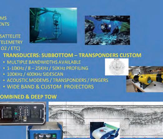
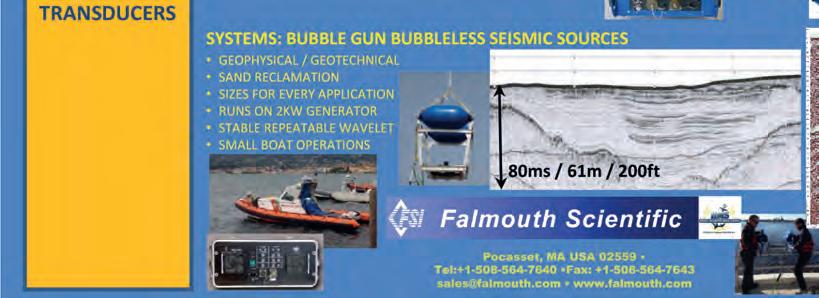
Falmouth 18
Hexagon (Leica Geosystems) 18, 24
Hypack 36 Kongsberg 55 MacArtney 12 Nortek 2 PyroScience 54 RIEGL 14 Saab Seaeye 7 SBG Systems 14

Seabed 23
Teledyne Geospatial 4
Teledyne Marine 20 Terradepth 34 University Southern Mississippi 42 Valeport 33
Hydro INTERNATIONAL | BUSINESS GUIDE 2023 | 5 EDITORIAL
info@hydrografie.info
ADVERTISERS
Huibert-Jan Lekkerkerk
Talking About Hydrographic Revolutions
Over the years, hydrography has experienced several revolutions, both in terms of technology and standards, which culminated in November 2022 in the IMO adopting a Resolution on Performance Standards for Electronic Chart Display and Information Systems (ECDIS). This brings S-100 and related products a step closer to becoming reality at sea and these, in turn, will pave the way for autonomous navigation and a complete digital twin of the ocean. But how did we get to this stage? What were the main innovations that brought us to where we are today?
The first revolutionary development in hydrography came as hardware. The German physicist Alexander Behm was granted patent no. 282009 in July 1913, which referred to a method for measuring ocean depth based on sound and echo intensity. Before this, Behm had developed photographic recordings of sound propagation based on experiments in an eight-litre aquarium to study sound propagation in water. In the best engineering tradition, Behm continued his experiments, and in the years to follow he developed a working echosounder based on the echo time and his short time meter, with which he measured the smallest time units in a technically simple and onboard way.
In 1922, hydrographic surveying made a quantum leap with the introduction of hydroacoustic methods for measuring water depths. It is no coincidence that the establishment of the precursor to the IHO in 1922 – the International Hydrographic Bureau – took place at the same time as the introduction of electronic solutions for systematic surveying of the seabed. The annual bulletin of the Bureau – the International Hydrographic Review – was full of articles over the following decade discussing the new opportunities that this technology brought to civil and naval applications.
CHART STANDARDIZATION
Moving forward another 50 years, the publication highlighting the 50th anniversary of the IHB in 1971 announced the first steps toward the creation of an international series of nautical charts – the INT charts. Based on an agreed cartographic representation of natural and anthropogenic features in the marine environment and a common symbology associated with them, this series aimed to create a consistent global portfolio of bilingual nautical charts underpinning the rapid globalization of sea trade and supporting the safety of life at sea. The INT chart standardization became (and still is) one of the pillars of the IHO as a standardization body. The introduction of the INT charting scheme was not only a great achievement in standardization, but also marked the end of the dominance of a handful of chart-producing nations running a global portfolio in their mother tongue. INT charts became a symbol of national sovereignty and pride for countries that had never before engaged in surveying and mapping of their domestic waters. They were therefore the main driver of the now 98 coastal states that constitute the IHO and that are committed to international cooperation based on agreed technical standards.
It took approximately two decades before the INT process was in full motion. At this time –late 1980s, early 1990s – another revolutionary development appeared on the horizon, once more driven by hardware but now combined with a completely new element: software. The approach to bringing digital nautical charts onboard was remarkable since it was top-down. The IMO and IHO created performance and technical requirements for the functions of this new device: ECDIS. IHO Standards for the format and presentation of the data content were successfully tested for prototypes, but motivating national Hydrographic Offices to regularly produce data in S-57 ENC format
proved difficult, so that the ‘fuel’ for these off-the-shelf computer-based devices was inadequate. This changed as companies conquered the market with payable systems offering all the advantages that electronic (or, as we say today, ‘digital’) navigation holds, and high-quality and up-to-date nautical chart data coverage has been achieved as Hydrographic Offices have added ENCs as products to their traditional paper chart portfolios. Today, about 70 national Hydrographic Offices produce and disseminate ENCs for their waters. The market is fed by a collaborative trio of data producers, private data providers and OEMs delivering the onboard ECDIS devices.
ENC/ECDIS is one of the best examples of global technical standardization led by intergovernmental organizations, here the IMO and the IHO, in collaboration with industry. The top-down approach bore results in the end but needed a push from industry. Soon after consolidation of this technological approach from the late 1990s, hydrography got another boost – this time from the larger community of marine stakeholders.
| BUSINESS GUIDE 2023 | Hydro INTERNATIONAL 6
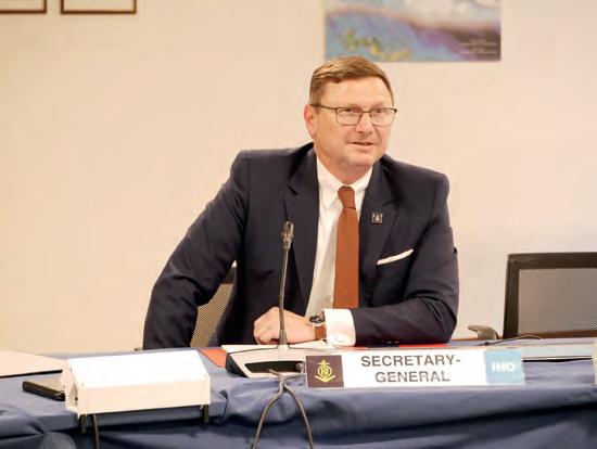
PERSPECTIVES | BY MATHIAS JONAS, SECRETARY GENERAL, IHO
Mathias Jonas.
TAKING ECDIS TO THE NEXT LEVEL
In spring 2022, the IHO submitted draft amendments for consideration to IMO’s Sub-Committee on Navigation, Communication, Search & Rescue (NCSR) on Performance Standards of ECDIS (MSC.232(82)). The IHO initiative included engagement with Member States and international organizations (CIRM, IEC and INTERTANKO) during the preparation of the proposed amendments to resolution MSC.232(82). NCSR9 endorsed the revised ECDIS Performance Standards in June 2022 and submitted them to the IMO Marine Safety Committee (MSC) for adoption. On 11 November 2022, MSC106 adopted the Resolution on Performance Standards for Electronic Chart Display and Information Systems (ECDIS), thereby making the use of S-100 and its related products a reality for improving safety of navigation. S-100 ECDIS will be legal to use after 1 January 2026 with a transition phase until 1 January 2029, when all new systems must comply with the new IMO Resolution on ECDIS Performance Standards.
IMO’s final approval marks the end of a long process to enable the IHO S-100 concept to become an inherent part of the IMO regulatory framework for international shipping. Its strategic relevance cannot be underestimated. This decision reaffirms the instrumental role of the IHO as IMO’s partner in the integration of hydrographic elements into the next phase of the digitalization of sea transportation. S-100 is a revolution in software. Based on the ISO 19000 Standards series for geoinformation, it has the potential to overcome the paradigm of
frozen functionality of the first generation of ECDIS through standardization. S-100 derivatives can breathe, which means that constant update mechanisms such as those in smartphone app technologies will become common for software in the marine domain. Moreover, the multitude of data formats carrying content such as bathymetry, aids to navigation and ocean weather will always be interoperable, so that they can be meshed by end-user devices to fit the purposes of the wider user community. S-100 derivatives are democratic, as the various data formats are hosted on the web, and their home is the IHO’s S-100 Geospatial Information Registry. Interested communities, of which there are potentially many, can register and maintain their own formats and export tools for integration in dedicated software applications: IALA and WMO are two major partners bringing the S-100 concept to the field.
Because of the strategic importance of this work, the IMO invited the IHO to keep it informed on the development process of the IHO S-100 framework standard. Taking ECDIS technology to the next level will be instrumental for progress in supporting green shipping and the blue economy.
The S-100 mechanism and its derivatives are inherent to two more revolutions: autonomous navigation and the digital twin of the ocean, which are more closely connected than they may at first appear. Autonomous sea operations require machine-to-machine data exchange and automated decision-making. These are

core characteristics of digital twins, which are virtual representations of physical objects and systems (in this case the ocean or a part of it) and have in the past been widely applied in the engineering realm for tasks such as engine optimization and port management. Digital twins include predictive and data-driven models that users can interact with to support their needs. Digital twins thus provide the ability to make informed operational, management and policy decisions for the real twin. This calls for data standardization as the basis – data standardization being one of the IHO’s strongest competencies. The IHO strategy embraces all these themes, which are expressed in the IHO’s 2023 motto: Hydrography – underpinning the digital twin of the ocean. To make this a reality, the IHO will focus on its S-100 Implementation Roadmap for the rest of this decade.
Mathias Jonas is Secretary General of the IHO. He is also a master mariner, has a PhD in Nautical Engineering and was the national hydrographer and vice president of the German Federal Maritime and Hydrographic Agency. He has represented Germany in IMO and IHO organs since 1998 and is chairman of the Hydrographic Commission on Antarctica Hydrographic Standards and Services Committee, overseeing nine technical standardization working groups.
Hydro INTERNATIONAL | BUSINESS GUIDE 2023 | 7
EMPOWERING
Industry Survey: Technology and Energy Transition Bring New Opportunities
New Horizons for Hydrography, but Who Will Conquer Them?
Every year, Hydro International surveys the state of the hydrographic industry to gain a comprehensive understanding of the sector and the challenges it faces. The survey includes a series of multiple-choice questions, but also questions that allow for detailed, open-ended responses, giving us a wealth of information to analyse. After carefully reviewing and evaluating the survey results, we present our findings in this article, where you can learn about the main trends currently affecting our industry. We zoom in on four aspects: industry expectations, the main challenges/threats (i.e. what stands in the way of business growth and industry development), the most important technological developments and the main opportunities and drivers of growth.
We also address the types of survey projects likely to present the greatest business opportunities in 2023 and whether there is a correlation between the level of investment that companies foresee and these opportunities. Finally, the feedback provided by the survey participants gives us insight into the skills required by modern hydrographic professionals to meet today’s industry demands.

INDUSTRY EXPECTATIONS
The mood in the industry is good, as most respondents view the prospects for the hydrographic surveying industry in 2023 as better or much better than in the past couple of years: 43.4% of respondents said ‘better’, 37.6% said ‘much better’, 14.3% said ‘the same’ and only 4.8% said ‘worse’. Furthermore, 24.7% of respondents expect
their company to experience 5–10% growth between 2023 and 2026, 22% expect 0–5% growth, 18.8% expect 10–20% growth, 13.8% expect more than 20% growth, 9.3% expect stagnation, and 1.9% expect a decline (9.5% chose ‘not applicable’). These are resounding results, but perhaps some context is needed to identify what exactly is behind this widespread optimism.
8 | BUSINESS GUIDE 2023 | Hydro INTERNATIONAL
FEATURE | BY WIM VAN WEGEN, HEAD OF CONTENT, HYDRO INTERNATIONAL
Many hydrographic survey companies are moving towards the usage of uncrewed survey vessels (USVs). One example is Deep BV. Pictured here is the Deep Lorean, a Maritime Robotics Mariner 6 USV, safely and successfully performing an uncrewed survey for the Port of Rotterdam.
Industry prospects
The general consensus among hydrographic surveyors is that the industry will continue to be in demand in 2023, with potential for growth. This is attributed to an increase in offshore projects, the need for environmental protection, and advancements in technology. The blue economy – the sustainable use of ocean resources for economic growth, improved livelihoods and jobs – is also expected to play a role in the industry’s growth as coastal nations become more aware of its importance.
The statistics capture the reasons for the optimism very well, as the survey results show that the main drivers of expected growth are the adoption of new technology (51%), investments in staffing (33.1%) and available tenders (30.5%). Other factors that may contribute to growth include investments in training (27.6%), the growth curve of recent years (25.6%), business diversification (24%) and impacts of global and regional events and policy (22.4% and 21.1%, respectively).
The hydrographic industry is experiencing a boom due to a surge in worldwide government investment in the blue economy and renewable energy sources, particularly offshore wind farms, tidal and wave energy and cable route projects. This increased demand is bolstered by requirements for climate change mitigation and opportunities in the UN Ocean Decade. The UN Ocean Decade seeks to increase public awareness of the important role that hydrography, seabed mapping and marine data play in marine spatial planning, and the same awareness is created by the highly inspiring Seabed 2030 project.
CHALLENGES AND THREATS
To make the most of the great opportunities and solutions that our field has to offer the world, we must also be aware of the challenges that lie ahead, some of which are already troubling the sector. After all, these
challenges do exist, as the results of the industry survey once again underline. The survey participants agree that the hydrographic industry will face some major challenges in the coming years, including attracting and training a new generation of surveyors (26.8%), adapting to new technologies such as autonomy and AI (19.3%), training and competency development (18.4%) and enabling the reuse of survey data for other purposes (9.8%).

We also asked respondents what they regard as the three biggest challenges for hydrographic organizations in 2023. These were finding and retaining staff, training and competency development, and embedding new technology. Other challenges mentioned included data management, funding, dealing with government policies and regulations, meeting demand, the knowledge gap with clients and low-quality entrants.

One of the survey respondents critically reflected on the adaptation of technology: “It is evident that the onshore geospatial world is advancing rapidly, making it difficult for those
attempting to bring the same technology offshore to keep up. Even when the people using the technology are relatively young, often only 30 to 35 years old, the technology is often already outdated. To make things worse, the crews on vessels are often composed for 80% of contractors who are there to perform the same trick they mastered many years ago, making it almost impossible to give them proper training in the latest technology. It is therefore essential that companies provide the necessary training and resources to ensure that their staff can keep up with ever-evolving technological advancements.”
Not everyone shares the general optimism of the survey results; there are some serious concerns, often arising from circumstances beyond our sphere of influence. The main factors behind the predicted stagnation or decline include increasing operating costs, a shortage of qualified personnel, inadequate funding, a lack of investment in technology, and the unpredictable effects of regional and global events. These geopolitical factors can have a profound effect on the regional and even global
9 Hydro INTERNATIONAL | BUSINESS GUIDE 2023 |
economy; for instance, the link with increasing operating costs is indisputable. As one respondent said: “The drastically increased delivery time for equipment caused by the global supply chain crisis and the shortage of components is currently making it really difficult to source equipment on time to meet project deadlines.”
Therefore, although the results of this survey are largely optimistic, many survey respondents remain realistic and are aware of the underlying concerns. The main issue identified by many organizations is the lack of skilled personnel, as the availability and quality of offshore survey personnel is under pressure. This is a critical topic that needs to be addressed and reversed, as a striking number of survey participants highlighted the difficulty of finding personnel with the required knowledge of data acquisition and processing. Furthermore, retaining and developing sufficient qualified and experienced personnel to cover the increased activity safely is essential.
CHALLENGING PROJECT PHASES
Hydrographic surveyors face a variety of challenges, including limited budgets, logistical difficulties, problems with sourcing appropriate equipment and qualified personnel, rapid changes in technology, legal procedures, difficulties in matching new methodologies to specifications and tenders, and dealing with competition. Additionally, they must contend with local and international financing and political policies, administrative complications, equipment malfunction and outdated specifications, as identified in multiple comments from respondents. The major challenges are not so much technical, such as data acquisition and processing, but more business-related, such as specifications and tendering and sourcing of equipment and personnel.
TECHNOLOGICAL DEVELOPMENTS
There has been immense enthusiasm concerning the use of autonomy and robotics in the hydrographic survey industry in recent years. But what does the industry survey tell us

about the future of companies that build traditional hydrographic survey vessels? The survey results point to a combination of crewed and uncrewed vessels as the preferred solution, and deploying multiple unmanned USVs and AUVs is seen as the most effective way to map the oceans.
We asked the survey participants which technological advancement they expect to be the most influential driver of innovation in hydrography in the near future. The main answers were: robotics & autonomous systems (22.1%), uncrewed systems (21.0%), machine learning & artificial intelligence (15.2%), satellite-derived bathymetry (10.0%), UAV bathymetry (Lidar) (8.9%), real-time processing (6.5%) and open data (making survey data available for multiple uses) (5.4%). The miniaturization of sensors is also expected to play a key role in improving the capabilities of surveying and mapping the seabed.
Autonomy, robotization and machine learning systems will not render hydrographic surveyors obsolete (see box ‘Debate
10 | BUSINESS GUIDE 2023 | Hydro INTERNATIONAL
Skilltrade Cat B students installing a hydrographic survey system. As our survey reveals, the hydrographic industry needs to think about how to recruit, and more importantly retain, hydrographic professionals. This will require continued investment in qualified personnel.
statement’); instead, they can help to maximize the expertise of hydrographers across multiple projects and create a new work environment for those entering the industry. In the next decade, the advancement of technology will significantly improve hydrographic activity, although the human factor – the hydrographer – will remain the most important component.
ADOPTION OF NEW TECHNOLOGY
The adoption of new technologies is a major concern in the hydrographic industry, so we could not lag behind and surveyed the progress being made and readiness to use new solutions in the hydrographic community. We examined the adoption stages of autonomy, uncrewed systems and AI in the respondents’ organizations.
Hydrographic professionals are increasingly turning to robotic, uncrewed and autonomous surface vehicles (ASVs) to conduct seafloor surveys, and an increasing number of hydrographers believe that uncrewed surface vessels can support subsea inspection, construction support and hydrographic surveys. More and more organizations recognize the value of autonomy and say that they are prepared to join the mission working to achieve safer, faster and more sustainable operations.
AI is no longer just a buzzword, but the ever-increasing and affordable availability of capacity and computing power to process and store data have opened the doors to many new opportunities. The emergence of AI in marine
geomatics, ocean sciences and hydrography is increasingly visible, as reflected in the answers provided in this year’s industry survey.
Analysis of Artificial Intelligence: Organizations are still in the early stages of adopting AI, as only 7.85% of respondents said that AI is currently embedded in their organization’s operations, and a further 16.04% occasionally use it. There is a high level of interest in the technology, as 32.76% of respondents are reading up on it and 23.55% of respondents are developing solutions.
Analysis of Uncrewed Systems: Organizations are more advanced in their adoption of uncrewed systems, with 14.01% of respondents currently embedding them in operations and 25.16% occasionally using them. There is still more research to be done, as 20.06% of respondents are reading up on uncrewed systems and 15.61% are sourcing or testing solutions.
Analysis of Autonomous Systems: Organizations are in the middle stages of
adoption of autonomous systems, as 13.85% of respondents say they are embedded in their organization’s operations and 21.62% occasionally use them. Again, there is a high level of interest in the technology, as 29.73% are reading up on autonomous systems and 18.92% are developing solutions.


OPPORTUNITIES AND DRIVERS OF GROWTH
The offshore wind industry and related hydrographic sector are keen to decrease their reliance on fossil fuels and their CO2 emissions through the use of cost-efficient environmental assessment services. The same applies to more traditional hydrographic surveying and mapping tasks. These industries can reduce their reliance on costly, conventional solutions and make a positive impact on the environment by integrating sensor technology with unmanned and autonomous vessels, which could be a viable solution to this issue. One of the noteworthy outcomes of this year’s industry survey is that
11 Hydro INTERNATIONAL | BUSINESS GUIDE 2023 |


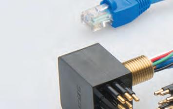
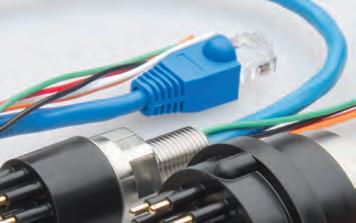
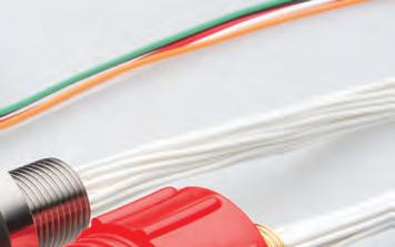

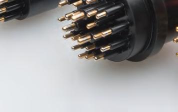


Recognised throughout the industry Full range of Ethernet connectors More than 40 years proven track record Wet-mate connectors Denmark Norway Sweden Finland United Kingdom Netherlands Germany Poland France Spain Portugal Italy UAE Israel Turkey South Africa USA Canada Mexico Colombia Chile Brazil Singapore China India Pakistan South Korea Japan Taiwan Australia Available worldwide
We asked respondents what types of survey projects they expect to provide the best business opportunities in 2023. These are the top seven responses.

this is often seen as a business opportunity, as many service providers regard this as a unique selling point: sustainability as an opportunity and driver for growth.
KEY TAKEAWAYS
Technological developments in the next ten years will undoubtedly have a huge impact on the role of the hydrographic surveyor. Automation will be a vital aspect of our profession, as well as more efficient and cheaper data collection methods. The use of unmanned vehicles and machines will also become more common, and surveyors will need to develop new skills to control multiple systems at once.
The biggest challenge for the hydrographic industry in the coming years will be to attract and train a new generation of surveyors, followed by adapting to new technologies (autonomy, AI, etc.) and training and competency development. The development of AI and machine learning systems will require surveyors to become data and IT specialists, rather than mapping and sensor
specialists. Other challenges that were identified include open data – enabling the reuse of survey data for other purposes – the management of hydrographic data, dealing with government policies and regulations, fulfilling the potential role in solving the climate problem, preventing a ‘race to the bottom’ (i.e. keeping standards high) and bridging the knowledge gap with clients, which is a topic worthy of further discussion in forthcoming issues of Hydro International
Once again this year, the industry survey has yielded an abundance of invaluable insights that will serve the Hydro International editorial board for the foreseeable future. We have used some of these findings to shape this article, yet many of the most significant discoveries could not be included due to our desire to keep the article to a manageable length. Therefore, we will be featuring several stories over the coming year based on the survey results. We would like to thank all those who took the time to complete the survey.
Who are the survey respondents?
The survey respondents are employed by a contract surveying company (18.6%), a surveying consultancy company (17.5%), a hydrographic office (13.1%) or a research or educational institute (12.4%) – representing the vast majority of organizations that employ hydrographic professionals.
A bit more background information on the respondents sheds light on their role within their organization. They are most commonly employed in surveying operations (49%), project management (42.5%), research and development (33.8%), team management (33.5%), general management (22.7%), and marketing and sales (16.3%).

Debate statement:
“In ten years’ time, hydrographic surveyors will have been replaced by robotization and AI.”
If the view of the average hydrographic professional were to be expressed in a few sentences, it would look something like this: Combining human intuition and machines using AI seems to be the most successful approach. As chess grandmaster Gary Kasparov, who in 1997 became the first world champion to lose a match against an AI-driven machine when he lost to the IBM supercomputer Deep Blue in a highly publicized match, aptly put it: “Machines have calculations, people have understanding. Machines have instructions, we have meaning. Machines have objectivity, we have passion. People have dreams, machines don’t.”
In the next 10 to 20 years, the capabilities of robots will continue to increase. What implications does this have for the professions in the hydrographic sector? Could jobs be threatened by robotization and the development of AI? Or is the reality more nuanced – AI may solve all kinds of problems and uncertainties that stand in the way of progress in our field, but this does not make people obsolete.
Wim van Wegen is head of content at GIM International and Hydro International. He is responsible for the print and online publications of one of the world’s leading geomatics and hydrography trade media brands. He is also a contributor of columns and feature articles, and often interviews renowned experts in the geospatial industry. Van Wegen has a Bachelor’s degree in European Studies from the NHL University of Applied Sciences in Leeuwarden, the Netherlands.
wim.van.wegen@geomares.nl

13 Hydro INTERNATIONAL | BUSINESS GUIDE 2023 |


LIGHTWEIGHT TOPO-BATHYMETRIC UAV LASER SCANNER www.riegl.com EFFICIENT HIGH RESOLUTION SHALLOW WATER BATHYMETRY FOR COASTAL MAPPING AND RIVER SURVEY Explore the full portfolio of proven RIEGL LiDAR sensors and systems www.riegl.com newsroom.riegl.international Scan this QR code to explore RIEGL‘s performance in topo-bathymetric laser scanning. Austria | USA | Japan | China | RIEGL WORLDWIDE | Australia | Canada | United Kingdom • lightweight 9.8 kg (20 lbs) • ideally suited for integration on UAVs • green laser providing more than 2 Secchi depths water penetration • measurement rate 50 kHz - 200 kHz • integrated inertial navigation system and digital camera GL NEW State-of-the-art Motion & Navigation Solution Navsight Marine Solution Qinertia The Next Generation INS/GNSS Post-processing Software
www.sbg-systems.com Making Hydrographers’ Tasks Easier
Courtesy of Cadden
Empowering ocean exploration by increasing diversity, one project at a time
Map the Gaps: Connecting People and Oceans
Map the Gaps is cultivating and empowering a growing network of professionals, organizations and communities working together to create new ways for interacting with, understanding and protecting the seafloor. The organization helps to increase diversity, equity and inclusion in the ocean mapping community and provide access to discovery expeditions and leading technology.
Map the Gaps’ vision is to promote discovery, knowledge and connection to the oceans and coastal communities by enabling and empowering a diverse global network of relevant professionals.
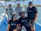
THE PEOPLE OF MAP THE GAPS
When a small group of early-career ocean professionals, all alumni of the Nippon Foundation/GEBCO Training Program, put together a proposal in response to the Shell Ocean Discovery XPRIZE competition, little did they know that over the next three years, they would cultivate a diverse and remote team of people from all over the world, work closely with an advisory team of experts and industry partners, raise over US$6M, spur the launch of a commercial USV company, and win the
prestigious distinction of Grand Prize Winner of this global challenge.
When the smoke cleared, a core group reflected on their triumph and decided to coalesce their experiences into a shared mission of supporting ocean discovery, but with an aim to empower others to get involved while at the same time contributing to new discoveries. In 2019, Map the Gaps was founded as a US-based 501(c)3 non-profit organization by a small group of volunteers dedicated to changing the face of ocean discovery.
Map the Gaps draws on an international community of ocean explorers, conservationists, educators and early-career scientists. Representing a diverse global network, many are the 100+ alumni of the Nippon Foundation/ GEBCO Training Program, having studied ocean mapping at the University of New Hampshire’s Center for Coastal and Ocean Mapping since the start of this training programme in 2004. Others are passionate professionals, NGOs,
commercial partners, ocean community leaders and interested individuals.
One of the short-terms strategic goals of Map the Gaps is to increase the network and diversity of people involved in Map the Gaps and to grow and scale meaningful relationships with partners and collaborators.


THE PROJECTS OF MAP THE GAPS
Committed to empowering others to make a difference in ocean exploration, Map the Gaps operates primarily under a services model, supporting scientific exploration, conservation and ocean discovery. Map the Gaps works with partnering organizations who sponsor expeditions, fund data processing projects or engage to provide training opportunities. Serving through the provision of ocean discovery opportunities, while increasing global knowledge of our oceans, is only a portion of what Map the Gaps does. Outreach and engagement with communities outside the norm helps to provide inspiration and empowerment to the next
Map the Gaps is dedicated to increasing awareness, equity and diversity among the ocean mapping community through outreach and mapping activities.
15 Hydro INTERNATIONAL | BUSINESS GUIDE 2023 |
FEATURE | BY ROCHELLE WIGLEY AND TIM KEARNS
generation of knowledge workers everywhere. Map the Gaps will achieve this by building on existing collaborations and partnerships with industry, academia and philanthropists.
The role that Map the Gaps can play in supporting a global initiative to better understand our planet is best described through some example projects.
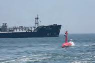
Uncrewed Trans-Atlantic Survey (UTAS) was an uncrewed over-the-horizon bathymetric survey in UK waters undertaken in July/August 2020. The survey was carried out by SEA-KIT’s USV (USV Maxlimer) mounted with a Kongsberg EM710 multibeam. Along with project partners, Map the Gaps managed the survey operations and data acquisition, data processing and production of the final data products. This was undertaken using Teledyne CARIS Mira AI and a globally distributed team, all while working remotely. Data was post-processed by Map the Gaps, allowing the evaluation of different approaches using tools
for data processing and product generation. Funding for Map the Gaps came from the Nippon Foundation-GEBCO Seabed 2030 Project, and all data was turned over to this global initiative. This proof-of-concept project demonstrated the value of remote surveying and processing operations with a global network of Map the Gaps surveyors.
Caladan Oceanic required in-person and remote capabilities for the mapping operations of the DSSV Pressure Drop over a three-year period from 2020 to 2022. Map the Gaps’ surveyors supported the deep dive campaigns undertaken by the Limiting Factor manned submersible through seafloor mapping and relevant product development. In addition to this more commercial role, Map the Gaps was also supported by the Nippon Foundation-GEBCO Seabed 2030 Project for transit mapping. Victor Vescovo understood the critical value of data collected during transits as an important contribution towards helping to map our oceans.
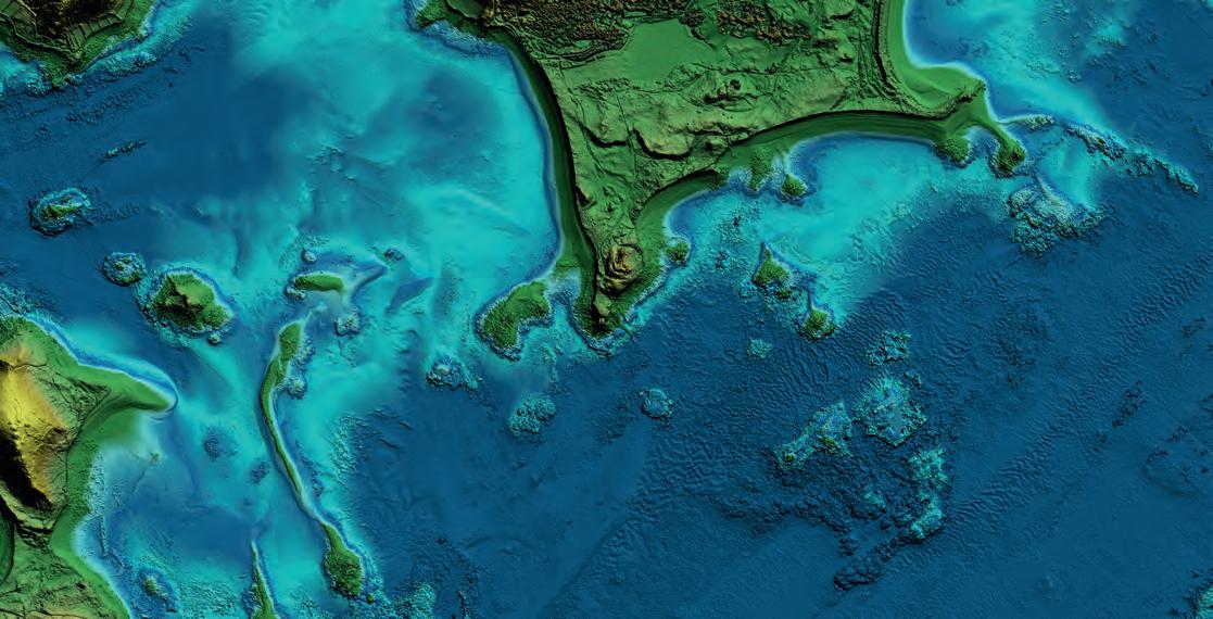
World renowned aquanaut, Fabien Cousteau, has the ambitious goal of developing and deploying the ocean equivalent of the International Space Station – PROTEUS. In conjunction with the Fabien Cousteau Learning Center, Proteus Ocean Group, R2 Sonic, QPS and Carmabi, Map the Gaps coordinated and led an exploration mission to provide detailed bathymetry of the entire Curaçao marine protected area. This data set, never surveyed in high resolution before, will be used to prepare for the design and planning of the PROTEUS underwater research station. Specialists were selected from neighbouring communities, further reinforcing Map the Gaps’ commitment to empowering regional people where possible.
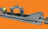
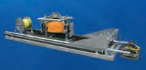
The GO-MARIE (Glacier Ocean Mapping and Research Interdisciplinary Effort) Bathymetry for Science Greenland 2022 expedition was a proof-of-concept project that demonstrated that a low carbon solution, a repurposed 22-metre steel hulled schooner, can be used

16 | BUSINESS GUIDE 2023 | Hydro INTERNATIONAL
area of the Caribbean Island of Curaçao in high resolution in preparation for the world’s largest underwater human habitat. (Image courtesy: Tomer Ketter)
for bathymetric data acquisition in a rugged and challenging environment. The sailpowered survey vessel also operates at a fraction of the cost of a traditional hydrographic survey vessel. Ocean Research Project, Map the Gaps and a wide range of technology supporters (Trimble, R2 Sonic, Applanix, RBR, etc.) participated in this successful endeavour, with financial support from the Nippon Foundation-GEBCO Seabed 2030 Project. Map the Gaps was involved in this project from early on and assisted in development, fundraising and planning as well as the mapping operations.
OUTREACH OF MAP THE GAPS
Exploration and bathymetric survey support are only a part of what Map the Gaps provides to the ocean community. The Map the Gaps Symposium on ocean discovery, convened on behalf of GEBCO, raises awareness of the importance of ocean exploration by bringing together a wide range of individuals interested in or engaged with ocean discovery. As a hybrid event open to all, the symposium seeks to expand and diversify the community of individuals and organizations passionate about the oceans. Interesting topics such as ocean exploration technologies, expeditions, data and information pipelines, policies and communications are shared and discussed.
Map the Gaps holds training courses for the participants of the IHO-Nippon Foundation GEOMAC project. This workshop style course allows Map the Gaps trainers to introduce basic ocean mapping techniques and concepts to cartographic students and strengthens the broader Nippon Foundation alumni network.
THE FUTURE OF MAP THE GAPS
The short-term strategic goals of Map the Gaps are to increase funding levels to support the ongoing development of the extended network, and to foster the creation of more expeditions and opportunities for an increased community. Additional funds will also provide for the expansion of the outreach goals, to include training/webinars, partnerships and growth of the Map the Gaps Symposium.
All of the above will raise awareness of the importance of ocean discovery and increase exploration opportunities and the diversity of the ocean community.

In conclusion, Map the Gaps has involved over 20% of the Nippon Foundation/GEBCO Training Program alumni in its projects, and has distributed over US$300,000 to this global network of professionals since its inception in 2019. The economic impact of this cannot be overstated. Their professional development,
local economy and region all benefit from the Map the Gaps model. The model allows ongoing skills development for individuals, and increases knowledge through involvement in cutting-edge and/or proof-of-concept projects. This capacity development is then shared with individuals and their ocean-based communities who might otherwise never have this opportunity. A necessary conversation has started about the importance of diversity within global communities, equity among partnerships and inclusivity in collaborations.
Map the Gaps is contributing to a better understanding of the Earth’s oceans, while simultaneously empowering exploration by increasing diversity in the ocean community and providing a direct economic impact on the lives and local economies of this group of connected people.
Rochelle Wigley has a PhD in Geology from the University of Cape Town and is project director for the Nippon Foundation/GEBCO Training Program in Ocean Mapping at the Center for Coastal and Ocean Mapping/Joint Hydrographic Center, University of New Hampshire. She oversees administrative, educational and management issues related to the training programme, mentors the current students and is actively involved in maintaining the international network of the training programme alumni through the Map the Gaps non-profit organization. She was also co-lead of the GEBCO-Nippon Foundation Alumni Team, grand winners of the Shell Ocean Discovery XPRIZE

roxy@mapthegaps.org
Tim Kearns is chief information officer at the Great Lakes Observing System and is responsible for strategy, policy and the development of cyberinfrastructure. He founded Map the Gaps, along with several Nippon Foundation/GEBCO Training Program alumni, to expand the scope and scale of the Map the Gaps Symposium and to increase diversity, equity and inclusion in the ocean mapping community through mapping initiatives. Tim volunteers his time with Map the Gaps to support projects, deliver the symposium and grow the non-profit organization. Tim is a technology futurist with deep experience in marine information systems, mapping and visualization and data management.
tim@mapthegaps.org
17 Hydro INTERNATIONAL | BUSINESS GUIDE 2023 |
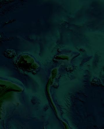
The Map the Gaps team is involved in the GO-MARIE project to map the uncharted glacial fjords of Greenland. (Image courtesy: Tomer Ketter)
Superior point density and depth penetration
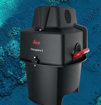
Leica Chiroptera-5 combines topographic and bathymetric LiDAR, delivering seamless data from water to land. The system provides 40% higher point density, a 20% increase in water depth penetration and improved topographic sensitivity compared to previous generations. The high-performance airborne sensor captures terrain data of coastal and inland waters to enable risk mitigation and more informed decision-making.
leica-geosystems.com/chiroptera-5
Leica
leica-geosystems.com
2022
All
reserved.
Geosystems AG
©
Hexagon AB and/or its subsidiaries and affiliates. Leica Geosystems is part of Hexagon.
rights
Five Questions to… Jurgen Beerens, Deep BV
Five questions on the state of the hydrographic industry

What do you see as the biggest challenges for the hydrographic industry as a whole in the coming years?
The hydrographic industry faces two major challenges in the coming years: achieving climate neutrality by 2030, and growing and maintaining a workforce in a growing market. Climate neutrality poses a unique challenge to the hydrographic industry: sea-going vessels cannot easily be converted to zero-emission propulsion, and even when conversion is possible, there is often a lack of alternative fuel supplies or electric charging facilities in the ports and harbours from which they operate. Meanwhile, the industry must find ways of growing and sustaining its workforce in a market that is expanding rapidly. The challenge here lies in providing training and opportunities for those who wish to join the industry, as well as retaining and further developing the expertise of those already employed.
Looking at hydrography, which technological developments do you expect to be the main drivers in the coming years?
The main drivers in the coming years will be automation and robotization. I’m not talking about full autonomy here, but rather any technology that reduces human input and allows us to do more with fewer people. By leveraging these advances, we can increase safety, efficiency and accuracy in our work. One of the main ways in which we can focus on sustainability is through robotization. By putting robotization centre stage, we can really make a big leap towards realizing our green ambitions.
Debate statement: “In ten years’ time, hydrographic surveyors will have been replaced by robotization and AI.” Do you: strongly agree, somewhat agree, neither agree nor disagree, somewhat disagree or strongly disagree? Please elucidate.
I strongly disagree with the statement. In ten years’ time, a large portion of dull, dirty and/or dangerous work will be done by unmanned vessels, with AI enhancements to the work processes. Instead of conducting hydrographic surveys out at sea, robotic missions will be planned and remotely monitored from control centres. Quality control of data processing and delivery will be a priority, as the demand for seafloor data is immense.
Which types of survey projects are paramount for your organization in the coming years?
When it comes to Deep BV’s survey projects in the coming years, they will primarily focus on the blue economy. These projects include offshore renewable energy and climate adaptation, which offer tremendous potential for companies like ours. Not only do these projects have the potential to be successful and profitable, but they also offer the opportunity to benefit our environment and society.
How would you prioritize technology investments in your organization over the next couple of years?
We are passionate about using new technology such as uncrewed surface vessels. These vessels have no crew onboard, so the experts
can stay onshore to collect and analyse the data. Our remote surveys ensure that the data we collect is transformed into valuable information for our clients. This is what makes our job so rewarding - the challenge of being creative and transforming the data into useful insights that benefit our clients.
If I were to prioritize technology investments in our organization now and in the near future, it would be clear: technology that enables us to do more work with fewer people and that helps us to reduce our CO2 and NOx emissions. Moving towards the use of uncrewed vessels for hydrographic surveying – as I mentioned above – is an effective way to accomplish these two goals. All of our projects strive for sustainability and the creation of green energy, and we have been creating offshore wind farms for over 15 years. However, the most important element of our vessels is their sustainability; we believe in electric boats and minimizing travel through remote working.
About Jurgen Beerens
Jurgen Beerens is director of Strategy and Business Development at Deep BV, a leading international engineering company specializing in hydrography, marine geophysics and oceanography. Since the company’s establishment in 1999, the Amsterdam-based firm has completed projects all over the world, from offshore to coastal areas, ports and inland waterways. Jurgen holds a BSc in Hydrography from the Hogere Zeevaartschool Amsterdam.

19 Hydro INTERNATIONAL | BUSINESS GUIDE 2023 | INTERVIEW | HYDRO INTERNATIONAL
From the seafloor to the surface…
Teledyne Marine delivers solutions
Teledyne Marine is a group of leading-edge undersea technology companies that have been assembled by Teledyne Technologies Incorporated. Through acquisitions and collaboration, over the past 16 years Teledyne Marine has evolved into an industry powerhouse, bringing the best of the best together under a single umbrella.

Each Teledyne Marine company is a leader in its respective field, with a shared commitment to providing premium products backed by unparalleled service and support.
www.teledynemarine.com

Towards Affordable High-end Solutions to Direct ROVs
Subsea Autonomous Navigation Capabilities for Small-sized Underwater Vehicles
Taking into account the increasing demand for autonomy in hydrography, this article examines the development of an innovative, small-sized subsea sensor fusion solution. This groundbreaking solution has the potential to automate ROV underwater monitoring and inspection tasks, at a cost of less than €10,000. This article delves into the results of the developed solution, as well as the initial validation tests to assess its performance. Furthermore, it outlines the next steps to further improve on the capability.
An increasing amount of inshore and offshore assets require inspection, repair and maintenance (IRM). Divers carry out the majority of this IRM work, but we are seeing the increased use of remotely operated underwater vehicles (ROVs) for this. The harsh conditions at sea present a high risk for divers, but also limit the effectiveness of currently available unmanned vehicle solutions.
To ensure safe and efficient autonomous task execution, autonomous underwater vehicles (AUVs) need to have sufficient knowledge of their environment, operator preferences and platform capabilities. In particular, the self-assessment of the navigation performance of AUVs is essential to ensure safe operations, especially when operating near infrastructure or other vessels. However, reliable underwater navigation solutions are either very costly or underperform in terms of providing accurate information on the position of underwater assets.
TNO has investigated and developed an innovative small-sized subsea sensor fusion solution capable of automating ROV underwater monitoring and inspection tasks with hardware costing less than €10,000. This took place within the Autonomous Underwater Remote Operations (AURO) public private partnership (PPP) project subsidized by Topconsortia Kennis & Innovatie (TKI)-Wind op Zee (WoZ). Validation tests were conducted in the Proeftuin op de Noordzee (North Sea Living Lab), a designated area for conducting experiments, to evaluate the system performance. This article describes the developed solution and initial validation tests to evaluate the system performance. The next steps to advance the developed capability are also outlined.
STATE-OF-THE-ART SUBSEA NAVIGATION AND MARKET TRENDS
The performance of more affordable sensor options has increased significantly in recent years. For example, multiple manufacturers are
now developing higher-end microelectromechanical system (MEMS)-based inertial measurement units (IMUs). These MEMS do not match the performance of the high-end fiber-optic gyro (FOG) IMUs, but have seen major improvements, for example in bias stability. Off-the-shelf products include the Honeywell HG4900 series and VectorNav VN2xx series. Besides MEMS IMUs, multiple lower-end Doppler velocity log (DVL) options are starting to become available, for example from Waterlinked and Cerulean.
Although cheaper sensor technologies are emerging, there are currently few completely integrated ‘budget’ positioning systems available. Larger unmanned underwater vehicle (UUV) systems typically have a high-end, bulky and heavy INS with integrated positioning sensors. However, new companies have emerged in recent years offering much smaller, affordable underwater vehicles. These systems could introduce significant cost reductions for
21 Hydro INTERNATIONAL | BUSINESS GUIDE 2023 |
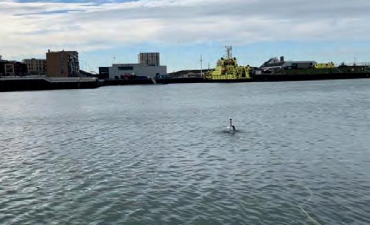
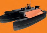
Figure 2: BlueROV2 operating autonomously in Scheveningen harbour.
FEATURE | BY JIM
TNO, THE NETHERLANDS
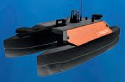
Figure 1: BlueROV2 with the TOPS navigation box integrated (left). TOPS watertight navigation box (right).
ROJER, VINCENT DE GEUS, BAS BINNERTS AND DANNY MAAT,
offshore operations. The aforementioned high-end positioning systems however do not fit on these smaller UUVs and are not feasible from a cost perspective.
Finally, there is an automation trend, since piloted UUV operation is often time-consuming and challenging because of harsh environmental conditions underwater. This could be done much more effectively if the UUV could follow an inspection trajectory in an autonomous manner. To enable safe autonomy, the position uncertainty must be incorporated into the planning phase to avoid collisions and guarantee that infrastructure will not be damaged by the UUV operation.
SUBSEA NAVIGATION SOLUTION (SOFTWARE AND HARDWARE)
The aim was to develop a budget positioning solution that combines cheaper sensors with advanced sensor fusion methods. In general, the budget sensors options will have lower specifications and be more affected by varying environmental conditions. The philosophy was to use sensor fusion to estimate the sensor properties in a pre-run calibration phase and then to compensate for these effects, allowing for ‘near high-end’ performance. The following sensors were used in the sensor fusion:
• VectorNav VN200 IMU (3-axis accelerometer, 3-axis gyroscope and 3-axis magnetometer)
• BlueRobotics 30 bar pressure sensor
• Waterlinked A50 DVL
• RTK GPS using the uBlox M8P with dedicated base station (2cm precision)
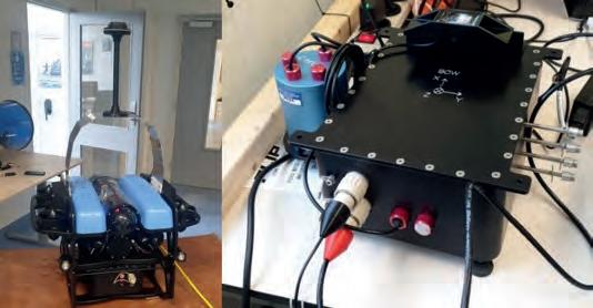
A watertight sensor box contains the hardware and is integrated under the BlueROV2 (see Figure 1).
The BlueROV2 is an affordable and small-sized ROV (45x34x25cm, 12kg) made by BlueRobotics. TNO has developed the Timing Orientation & Positioning Service (TOPS), which combines multiple state-of-the-art fusion algorithms into a single high-end fusion engine. TOPS was run in real time on the processing board integrated in the sensor box. The RTK GPS antenna was designed to stick out of the water to let the BlueROV2 be fully submerged, mimicking realistic conditions for all underwater sensors while maintaining an accurate RTK GPS signal. This makes it possible to carry out a pre-mission sailing pattern in which the RTK GPS can be used in the sensor fusion. This pre-mission sailing is essentially a calibration phase in which the fusion engine establishes estimates for sensor properties (e.g. biases and scale factors). During the experiments, it was found that a calibration phase of approximately 90 seconds was sufficient for the BlueROV2 to dive below the water surface and safely carry out its mission.
To demonstrate the performance of the positioning system, experiments were done during the mission phase with the RTK GPS antenna above the water. The RTK GPS was manually disabled for the fusion engine after the calibration, but kept available as a reference signal to assess the fusion performance. To enable a comparison between combinations of sensors, the box was self-designed to house various sensors.
VALIDATION TESTS
The value of this innovation for technology integrators and end users was demonstrated using the BlueROV2 and TOPS navigation solution developed in the AURO project
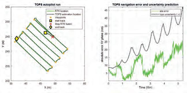
(software and hardware). To showcase how the navigation solution can be used to enable safe and effective operations, a simple autopilot capability was developed to enable the BlueROV2 to autonomously follow a pre-planned path in the horizontal plane (i.e. at a fixed depth). In this case, the demonstration showed a lawnmower type pattern to mimic seafloor inspection.
The RTK GPS was used by the TOPS fusion during the first manually controlled sailing task in the calibration phase. Afterwards, the RTK GPS was no longer used by the TOPS fusion engine and only acted as a reference to assess the TOPS performance over time. TOPS ran at 200Hz in real time and estimated both the position and the position uncertainty.
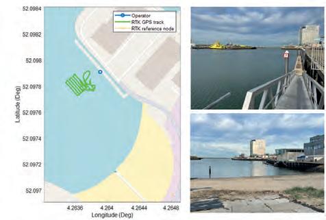
The results of the tests show an approximately 0.4% error in distance travelled. Figure 2 shows the BlueROV2 operating autonomously in Scheveningen harbour, while Figures 3 and 4 depict the test setup of the demonstration, the tracks sailed by the ROV and the error and uncertainty evaluation of the TOPS uncertainty prediction.
CONCLUSIONS AND WAY FORWARD
The AURO project showed that state-of-the-art sensor fusion can be used to achieve high-end navigation performance using low-end small-sized navigation sensors. This was demonstrated through various experiments in Scheveningen harbour with a self-developed sensor box integrated with a small-sized ROV (BlueROV2 from Blue Robotics). The sensor fusion was done using TOPS, which is a TNO-developed sensor fusion framework that combines multiple state-of-the-art fusion
Figure 4: ROV sailed track (left) and uncertainty and error evaluation based on data acquired during preparation for the final demonstration (right).
22 | BUSINESS GUIDE 2023 | Hydro INTERNATIONAL
Figure 3: Test setup and ROV sailed track, based on data acquired during preparation for the final demonstration.
algorithms. The total hardware cost for the sensors was below €10,000, and their size and weight allow them to be integrated into all smaller vehicles currently available. The research also showed that it is possible to generate accurate estimates of the position uncertainty during operation.
Next steps should be to further validate the developed technology under different offshore conditions and by system end users, to ensure optimal teaming between the robotic platform and its operator.


ACKNOWLEDGEMENT
This work was made possible through a TKI-WoZ PPP project conducted with the Dutch Ministry of Defence, Boskalis, RWS, Tree-C technology, IV-Infra and Aquatic Drones.
Jim Rojer received an MSc degree in Control and Simulation from Delft University of Technology in 2017. In the same year, he founded a startup for the advanced control of multi-rotor drones. In 2018, he joined the Intelligent Autonomous Systems department at TNO as a scientist, where he focused on the algorithmic development of the TOPS sensor fusion framework.
Vincent de Geus received an MSc degree in Systems and Control from Delft University of Technology in 2010. Since then, he has worked in the field of high-fidelity flight simulators with a focus on software engineering. In 2019, he joined the Intelligent Autonomous Systems department at TNO as a systems engineer. He is currently responsible for the design and development of the TOPS software framework.


Bas Binnerts received his MSc in Mechanical Engineering, Structural Dynamics and Acoustics from the University of Twente in 2012. In the same year, he joined the acoustics and sonar department as a research scientist, specializing in underwater acoustic modelling and autonomous underwater vehicles for both civil and military applications.
Danny Maat received his MSc Cum Laude in Electrical Engineering from Delft University of Technology in 1994. He joined TNO 25 years ago and became project manager of the Autonomous Intelligent Systems research group in 2015. He is project leader of AURO, TNO portfolio manager of Positioning, Navigation & Timing (PNT) and product manager of the Timing, Orientation & Positioning Service (TOPS) software suite.
www.seabed.nl


23 Hydro INTERNATIONAL | BUSINESS GUIDE 2023 |
We would like to shine a light on some of our rental products
Getting to the bottom of things Seabed has a complete range of rental products available. Go to www.seabed.nl/rental or contact us at sales@seabed.nl for rates and availability. USV Bottom Sampling Positioning Sonar Underwater Sensoring
NV5 Maps Challenging Alaskan Coastal Zone for NOAA using Leica Geosystems’ Airborne Bathymetric & Topographic Lidar System
Lidar Technology Shines along the Alaska Coastline
The National Oceanic and Atmospheric Administration (NOAA) contracted NV5 Geospatial to define the shoreline in an extremely complex area of south-east Alaska as part of the NGS Coastal Mapping Program. The shoreline mapping required NV5 to collect subsurface bathymetric measurements as well as nearshore elevation data. NV5 deployed its integrated airborne Leica Chiroptera 4X and Leica HawkEye 4X Lidar sensors from Leica Geosystems, part of Hexagon, to capture the onshore topographic and shallow-water bathymetric data sets. Despite Alaska’s famously turbid water and poor flying conditions, the project successfully captured seafloor details to depths of 16 to 20 metres.
The Alaska Coastal Mapping Initiative is driven by the 2019 Presidential Memorandum on Ocean Mapping of the US Exclusive Economic Zone and the Shoreline and Nearshore of Alaska. The long-term goal is to create a seamless coastal map of the state by 2030, with a focus on the connection between the inland terrain and the offshore subsurface environment. The programme emphasises on the use of bathymetric Lidar technology.
The Alaska coastline has been poorly mapped due to the local conditions, including frequent rain and cloud cover, dramatic tidal swings and turbid waters caused by dynamic wave action. The
advantages of accurately mapping the shoreline are many – safer ship navigation, more efficient coastal resource management, better modelling of storm surges and coastal flooding, and improved benthic habitat stewardship. The airborne data collection would immediately impact the coastal mapping project, as the nearshore bathymetric measurements would be supplied to the sonar-equipped vessels also taking part in the survey initiative to keep them operating in deeper waters. “NOAA is trying to get very accurate and precise data to promote the safety of all the vessels working in these complicated environments,” said Andres Vargas, technical expert at NV5 Geospatial.
The selection of NV5 to map one of the most challenging parts of the state was a natural one, since the firm based in Corvallis, Oregano is an experienced user of Leica Geosystems’ airborne topographic and bathymetric Lidar sensors, which are capable of acquiring onshore terrain and offshore water depth data simultaneously – representing a significant time saving in environments where suitable flying conditions are limited.
NOAA assigned NV5 two project areas, including about 630 miles of rugged shoreline in the Revillagigedo Channel near Ketchikan, Alaska, totalling 350 square miles in an extreme fjord-filled landscape.
Project specifications called for capturing the aerial bathymetric Lidar points with a minimum density of three points per square metre (ppm) within two hours of low tide. Also requested to precisely delineate the land-water boundary was 25-centimetre four-band multispectral optical imagery at low tide within 30 days of Lidar operations. The target acquisition window was between May and October 2021.
NV5 deployed its Leica Chiroptera 4X and HawkEye 4X integrated Lidar system to Alaska aboard a Cessna Caravan. The Chiroptera 4X is a dual laser, designed specifically for simultaneous collection of high-resolution terrestrial elevation and
24 | BUSINESS GUIDE 2023 | Hydro INTERNATIONAL sponsored article
Topobathymetric Lidar point cloud coloured by RGB imagery on land and depth underwater.
shallow-water bathymetric points. The bathymetric laser operates in the visible green portion of the spectrum, which penetrates the water column to a nominal depth of 30 metres with 0.15-centimetre vertical accuracy at a five ppm density in clear waters and during ideal surveying conditions. The near-infrared topographic laser has a typical vertical accuracy of 15 centimetres.
While the Chiroptera 4X is a stand-alone system, Leica Geosystems designed the HawkEye 4X module as a companion device to collect deeper bathymetric data when integrated with the Chiroptera. The complementary HawkEye typically adds 40–50% depth penetration, with an accuracy exceeding IHO Order 1. Integration of the sensors enabled NV5 to acquire onshore, shallow-water and deeper-water data in a single flight –maximizing the handful of good flying days available.


CAPTURING DATA IN EXTREME CONDITIONS


In preparing for deployment, NV5 knew the harsh conditions in Alaska would be a challenge that required special procedures. Most notable were the low-lying clouds that limited flight operations and nearly relentless winds that kept the waters dynamic and turbid. Another issue was the dramatic terrain of the fjord landscape, which sees the shoreline in many places rising several hundred feet vertically out of the water.
Finding flat ground for the placement of survey control markers was difficult in the rugged topography covered by dense vegetation in many areas. The team surveyed 164 points, including the mooring of buoys in the water. These buoys not
only served as control points but also monitored water clarity and relayed these measurements to the NV5 team. This information proved critical in deciding daily where water conditions were suitable for airborne Lidar operations.

Windy weather created choppy waters, which increased turbidity, and the flight planners quickly noticed patterns in the wind-turbidity conditions. Winds from certain directions roiled the water more severely than from others. In fact, the wind direction was nearly as important as wind speed in reducing water clarity. Meteorological predictions helped give the crews an edge in planning the next day’s flights based on expected wind conditions.
An unexpected challenge that required an on-site modification of airborne operations was related to the extreme terrain and cloudiness. NOAA specified the collection of ground elevation measurements for a half mile inland from the shore. Unfortunately, in that half-mile distance, the fjord walls rose so precipitously that flights over the land would have to be conducted at a much higher altitude than over the water. “With flights already limited by clouds, we decided to operate the Chiroptera/HawkEye system only over the water in some areas to focus on acquisition of bathymetric data,” said Vargas.
Even in steep fjords, the oblique scanning angle of the Chiroptera terrestrial laser successfully captured the shoreline, which was critical to the mapping project. But for surveying farther inland, NV5 brought a second aircraft on-site with a dedicated terrestrial Lidar to capture the additional data at the higher altitude – when weather allowed.
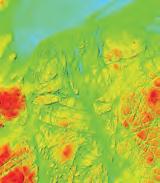
Hill shade model of the topobathymetric Lidar-generated DEM, coloured by depth to highlight areas shallower than 10 metres. Submerged rocks and a steeply rising coastline make this area dangerous and difficult to map with survey vessels.
CONCLUSION

Once the flight operations were completed, NV5 delivered the data to its Oregon headquarters for processing. The Leica Lidar Survey Studio software was used to extract and correct the elevation points for each flight line. NV5 then ran the data through a custom workflow to generate the point clouds and normalize the Chiroptera and HawkEye data sets for integration.

A key aspect of this process was finding relatively flat seafloor surfaces in the overlap area between the Chiroptera shallow data and the deeper HawkEye measurements. Technicians used this as the cut line where the two point clouds were merged to create a seamless bathymetric data set from the shoreline down to a maximum of about 20 metres in depth, where the Lidar penetration ended.
This bathymetric ‘extinction line’ at 20 metres depth was critical to the next and ongoing phases of the Alaska Coastal Mapping Initiative, explained Vargas: “Thanks to the highly accurate bathymetric and topographic Lidar data, NOAA will be able to carry on with the collection of multibeam sonar [aboard vessels] in a safe manner,” he said. “This was a very successful collection where the sensors performed admirably and characterized many complexities in the channel.”

25 Hydro INTERNATIONAL | BUSINESS GUIDE 2023 | sponsored article
Leica Chiroptera 4X & Leica HawkEye 4X. Leica Lidar Studio Software.

Zooming In on the Range of Vehicles for Hydrographic Surveying
A Classification of Survey Platforms


The life of a hydrographic planner used to be easy: you had a survey vessel from which (at least in nautical cartography) you deployed a number of survey boats (often sloops) with a simple sensor suite. However, the growth in different types of survey platforms (and sensors) and their accompanying abbreviations in recent decades necessitates some form of classification. While there are as many classification systems as people with imagination, in this article I present a system that I find usable in the surveying business.
CLASSIFICATION
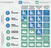
The classification chosen is:
- Medium: where is the platform (air, water surface, under water)?
- Manned/unmanned: does the platform have a crew?
- Freedom of movement: how much freedom of movement does the platform have?
- Degree of autonomy: how much autonomy does the platform have?
- Environment: which environment can the platform be used in?
- Size: what is the relative size of the platform within its class?
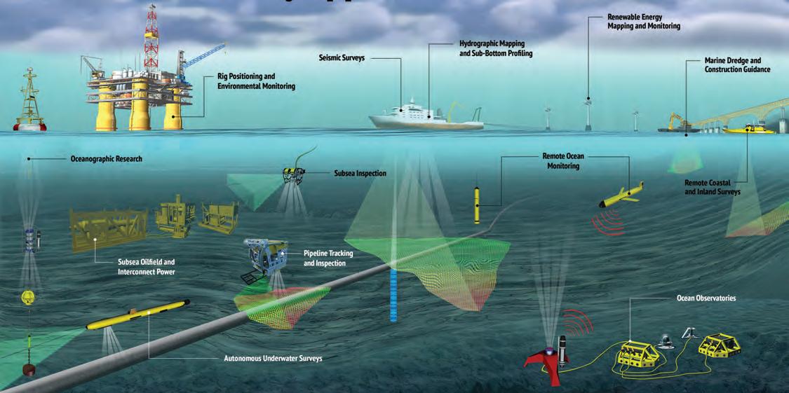
Medium
A first classification for survey platforms is the medium they operate in, or on, as this determines where the platform will be during the survey and which acquisition sensors and positioning systems can be used. In hydrography, we distinguish between air, water and the air-water interface. In the air, we find platforms such as manned helicopters, aeroplanes and satellites, but also unmanned aerial vehicles (UAVs) – commonly called drones – which also come in a multi-copter form or with fixed wings.
More traditional hydrographic platforms are found on or beneath the water surface, and include survey vessels, boats and buoys, as well as remotely operated vehicles (ROVs), autonomous underwater vehicles (AUVs) and towfishes.
27 Hydro INTERNATIONAL | BUSINESS GUIDE 2023 |
FEATURE | BY HUIBERT-JAN LEKKERKERK, TECHNICAL EDITOR, HYDRO INTERNATIONAL
Figure 1: Classification of ‘water’-related survey platforms.
Manned/unmanned
The second classification concerns whether the platform requires a crew or not, both above and under water. While underwater unmanned platforms such as ROVs have been the norm in surveying for several decades, a gradual shift is taking place above water: from traditional manned survey vessels to unmanned survey vessels (USVs).

Freedom of movement
The third classification considers the operational freedom of the platform, ranging from ‘fixed’ platforms such as buoys through towed platforms to free-ranging platforms such as submersibles, surface vessels and autonomous vehicles. The following sub-classification is used in this article:
- Anchored: the platform stays in one place (e.g. a buoy).
- Hoisted/towed: the platform is connected by a cable to a mother platform and has little or no control over its own position (e.g. a towfish). A special case is a remotely operated towed vehicle (ROTV), which combines a towed and a tethered platform to create limited freedom of movement.
- Floating: the platform relies on ‘nature’ to change location. A special case is the bathyscape, which has limited control over its vertical motion and floats horizontally.
- Tethered: the platform is connected to a mother platform but has some freedom of movement (e.g. an ROV (umbilical) and a USV (radio controlled)).

- Free-ranging: the platform can travel anywhere without external control and is limited only by its endurance and the environment.
Degree of autonomy
Closely related to freedom of movement is the fourth classification; the platform’s autonomy. A platform that is not free-ranging is by definition non-autonomous, as it requires an external

force to move. Regarding the autonomy of free-ranging platforms, we can adapt the classification used for autonomous cars from SAE J3016:
0. No automation: the platform is manned and manually controlled for both navigation and surveying operations.
1. Operator assistance: part of the steering is controlled, for example using an autopilot to control the heading of a vessel or automatic recording at the start of a survey line. The human operator is still fully in charge.
2. Partial automation: the platform can perform basic steering operations such as maintaining position using dynamic positioning or automatically steering a pre-defined line pattern and recording survey information
while using automatic depth filters. The human operator still monitors and can take control at any time, for example if environmental conditions change unexpectedly.
3. Conditional automation: the platform has environmental detection capabilities such as detecting other vessels or changing a survey pattern with changing depths. Human intervention is still required for critical actions or if the automation does not know what action to take. From this point onwards, remote control whereby an operator monitors multiple platforms is feasible.
4. High automation: human intervention is no longer required in most circumstances. Vessels can automatically take avoiding action
28 | BUSINESS GUIDE 2023 | Hydro INTERNATIONAL
Figure 2: Unmanned vs manned and surface vs underwater.
Figure 4: Degree of autonomy. (medium.com)
based on sensor input and/or design their own survey plans when circumstances change.
5. Full automation: the platform takes care of all tasks under all conditions. No human interaction or monitoring is required.
Many autonomous surface vessels (ASVs) are at Level 3 or Level 4 for navigation, meaning that they can take action themselves but require human intervention in specific circumstances. Most survey systems are however at Level 2, although nearing Level 3. The ASV as a total package can never be more autonomous than the lowest level, so Level 2 or at most Level 3.
Environment
The fifth classification is the environment that a platform is designed for. A submersible, ROV or AUV can be built for either shallow-water or deep-water operations. Research submersibles can have depth capabilities up to thousands of metres, while submersibles used for inspection work are limited to a few tens to a few hundreds of metres.
Surface vessels are also classified by the environmental conditions (specifically waves) that


they can withstand, often in combination with their endurance. A common classification is inshore and offshore survey vessels. Inshore vessels operate in restricted, often shallow, waters with smaller waves, while offshore vessels can operate in large, open bodies of water with higher waves.
Size
Survey platforms come in sizes ranging from a few decimetres for a very small ASV up to over 100 metres for a manned surface vessel for deep ocean work.

The size of the platform is often determined by other classification choices. For example, most unmanned platforms will be smaller than their manned equivalents, and an inshore vessel is usually smaller than an offshore vessel. Larger platforms can carry more personnel, sensors or stores, for different types of operations or greater endurance.
AN EXAMPLE: ROVS


To discover how this classification works in practice, let us consider the ROV. This boxy platform is commonly used for surveys
underwater. It is unmanned, but requires an operator (pilot) to control the ROV from the mother ship to which the ROV is connected using a tether (umbilical). Most ROVs have at best autonomy Level 2.

ROVs come in shallow-water versions for use on the continental shelf and deep-water versions for depths of thousands of metres. Finally, ROVs may be smaller, observation-class ROVs –carrying only cameras and small survey sensors – or larger, work-class ROVs – with manipulator arms and extensive survey suites. Sub-classes are also possible, such as small, medium or large versions of work-class ROVs.
Huibert-Jan Lekkerkerk is a contributing editor, freelance hydrographic consultant and author of publications on GNSS and hydrography and principal lecturer in hydrography at Skilltrade (Cat B) and the MIWB (Cat A) in the Netherlands. He is also a member of the IFHS initial HPAS panel.

29 Hydro INTERNATIONAL | BUSINESS GUIDE 2023 |
Critical Components of Hydrographic Efforts
The Case for Hydrographic Survey Vessels in Uncrewed Vessel Operations

The state of the art in autonomous surface vehicles has evolved tremendously, and these technologies will revolutionize the field of hydrography. However, our experience shows that developing these systems to their full capabilities while fulfilling NOAA’s hydrographic needs will continue to require the support of capable hydrographic ships.
Since 2015, the Center for Coastal and Ocean Mapping (CCOM) at the University of New Hampshire has deployed autonomous surface vehicles (ASVs) from NOAA Ship Fairweather (2018), Exploration Vessel Nautilus (2017, 2018, 2021, 2022 x 3), NOAA Research Vessel Shearwater (2017) and NOAA Ship Thomas Jefferson (2019 and 2022). The Center has also deployed ASVs from shore in NOAA’s Thunder Bay National Marine Sanctuary (2019 and

2021) and in countless day deployments from its own vessel and from shore off the New Hampshire coast. CCOM owns two oceancapable, diesel-powered ASVs, works closely with manufacturers of sail-powered ASVs and is at the forefront of active research and engineering focusing on the practical application of ASVs in marine science and hydrography. CCOM is also proud to maintain close collaborations with many corporate partners,
working to solve the challenges of creating practical robotic hydrographic survey platforms. Few are more excited about the revolution that these technologies will bring to the field of hydrography than the engineers and scientists now routinely conducting these operations.
BEST PRACTICES
In a 2020 technical paper published in the International Hydrographic Review (IHR),
31 Hydro INTERNATIONAL | BUSINESS GUIDE 2023 |
FEATURE | BY VAL
OF
Figure 1: The Center for Coastal and Ocean Mapping’s C-Worker 4 ASV, BEN, deployed from NOAA Ship Fairweather in the vicinity of Point Hope, Alaska.
SCHMIDT,
CENTER FOR COASTAL AND OCEAN MAPPING, UNIVERSITY
NEW HAMPSHIRE
CCOM presented best practices for ASV operations in hydrographic surveys (see Hydrographic Survey with Autonomous Surface Vehicles: A Best Practices Guide, IHR, 2020). This paper built on a 2015 workshop hosted by the National Oceanic and Atmospheric Administration’s (NOAA) Hydrographic Systems and Technologies Branch (HSTB) to explore and evaluate the state of the art of autonomous systems.
At this workshop, attendees defined a set of practical autonomy levels to provide a common understanding in discussions, and mapped these to real-world operating conditions. It became clear that any given mission, operating environment, vehicle level of autonomy and level of supervision determines a level of risk, which is broadly defined as risk to property and personnel as well as risk of failing to achieve the mission. No operation is risk-free, and therefore the IHR paper sought to make
recommendations to mitigate the risks involved in operating uncrewed systems.
The paper described the great variability in operating environments at sea, the ability of autonomous systems to perceive and safely navigate that operating environment and the need for operators to continuously adjust their level of supervision accordingly. Participants in the workshop noted that caution is warranted in uncrewed operations when the mission is complex, the operating environment harsh and the level of autonomy low. As the paper described:
“Even fully Attended operation [over a telemetry link] may not be a high enough level of supervision, particularly if the ASV’s sensors and operator interfaces do not provide good situational awareness. In this case, additional monitoring can be provided by limiting operations to within visual line of sight or with other ancillary systems. In some cases, any
ASV operation may be deemed too risky altogether.”


The considerable increase in recent years in the capability of uncrewed systems to perceive and react to hazards will continue. However, only by marrying uncrewed systems with local shipboard or shore-based operators and support personnel can supervision of these systems be adjusted to ensure safe operation over the range of environments required to make them useful or, if necessary, recover the uncrewed systems altogether. Therefore, maintenance of a hydrographic fleet of ships capable of collecting high-quality data, and husbanding these uncrewed vessels through the development of more advanced capabilities, is critical.
LEVEL OF RELIABILITY
At this inchoate point in industry development, the chance that a failure will require human intervention is relatively high compared to traditional vessels. Experience shows that uncrewed systems can struggle to accurately perceive the operating environment, can suffer from system failures in both hardware and algorithms more frequently than crewed vehicles, and contain sensors not necessarily designed for robotic systems or robotic sensors not designed for operation at sea. The loss of a single cable connection, trivially resolved by a human operator, can render an autonomous system wholly unable to complete a mission. In the worst case, when human operators are not available to intervene, simple failures can lead to navigational or environmental disasters. For systems intended to operate for long periods of time, deployed far from human operators, the level of reliability must greatly exceed that of the crewed vessels to be effective. The rapid pace of new and untested systems and the relatively low volume of production of robotic vessels, combined with the expense of testing these systems in a variety of conditions at sea, have not yet afforded the industry the opportunity to fully engineer and demonstrate solutions for high reliability.
There is a subset of uncrewed systems that scavenge power from the wind, waves or sun, operate at slow speeds and offer high endurance. Systems of this kind, operating in remote areas without on-site crewed vessel support can, however, also have operational drawbacks. The limited power available to these systems can translate to limited navigation authority in the presence of ocean currents and limited payload
32 | BUSINESS GUIDE 2023 | Hydro INTERNATIONAL
Figure 2: DriX-8, operated by the Center for Coastal and Ocean Mapping, during dead-vehicle recovery
Figure 3: DriX-12, owned and operated by NOAA, during sea acceptance testing at University of New Hampshire facilities in the summer of 2022.
operational times, negatively impacting the survey objectives. In addition, the power constraints often support relatively limited telemetry, limiting the ability of operators to maintain full situational awareness and quickly assess hazards, which requires limiting operations to maintain adequate safety. The long deployment times required of these systems increase the chance a failure will occur. When it does, any savings accrued by not deploying shipboard assets locally can be lost in
CONCLUSION
While the goal of fully autonomous survey systems operating efficiently for long periods of time is one we aspire to, the realistic vision for uncrewed systems is, at present, one that extends the capability of crewed systems to more nimbly and more cost-effectively meet the Nation’s survey needs. Crewed ships remain, for the foreseeable future, critical components of the Nation’s hydrographic efforts to ensure safe
in the local operating area of uncrewed systems and ensure the ability to meet the Nation’s hydrographic needs as we build towards a future of truly autonomous operations.
the response to a few faltering uncrewed systems at distant locations. For this reason, the real costs of operating these systems for long periods of
and responsible operation in all conditions. While the marine robotics industry has made great strides in these endeavours, it is not in the

Val Schmidt leads the marine robotics programme at the US Center for Coastal & Ocean Mapping, where he and a team of engineers and graduate students solve problems to “make autonomy practical”. Schmidt holds a Bachelor’s degree in Physics with Honours from the University of the South (Sewanee, TN, 1994) and a Master of Science in Ocean Engineering, with an emphasis on Ocean Mapping, from the University of New Hampshire’s Category A Hydrographic programme (Durham, NH, 2008). Schmidt and his team at CCOM have been deploying uncrewed vehicles from shore and ships at sea since 2008, for marine science and seafloor mapping missions around the world. These include recent missions with ASVs from NOAA Ship Fairweather (2018), Exploration Vessel Nautilus (2017, 2018, 2021, 2022 x 3), NOAA Ship Shearwater (2017) and NOAA Ship Thomas Jefferson (2019 and 2022).

33 Hydro INTERNATIONAL | BUSINESS GUIDE 2023 |
To find o ut mor e c ont act sa les@ val ep ort.co.uk +4 4 1803 86 9292 | ww w.v al eport .c o.uk Measured CTD and Turbidity, with all the benefits of the SWiFT SWiFT CTDplus Turbidity • Bathymetry • CTD & Environmental • Current • Sound Velocity • Tide AUV, R OV & ASV HYDR O GR APHY HYDR OMETRY METR OLOGY & POS ITIO NING OCEA NO GRA PHY PORTS , HA RB O UR S & DR E DGIN G RE NEWA BL E EN ERG Y Crewed ships remain, for the foreseeable future, critical components of hydrographic efforts to ensure safe and responsible operation in all conditions
Terradepth’s Absolute Ocean Increases Operational Efficiency for S. T. Hudson
S. T. Hudson Engineers, Inc. is a pioneer in state-of-the-art marine engineering and total harbour facilities and a specialist in marine technical services. It has provided professional consulting, surveying and engineering services for over 55 years and offers complete, cost-effective turnkey solutions across the US and internationally. Its experienced in-house team comprises engineers, environmental specialists, hydrographers, geophysicists, commercial hard-hat divers, estimators, construction managers, professional mariners, CADD/GIS experts and inspectors, all of whom assist clients on every aspect of a project: from the nearshore, to the docks, to the tanks, and everything in between. Hudson’s unparalleled history and experience allows it to cultivate long-term relationships with its clients, providing a team with the skill set and knowledge to enhance its clients’ business capabilities and project vision.
S. T. Hudson deploys sophisticated technologies from surface assets for bathymetric and geophysical surveys, comprising multibeam sonar, sidescan sonar, CHIRP and parametric sub-bottom profiling, transverse and stand-alone magnetometers, ultra-short baseline, single and multichannel ultra-high resolution seismic, autonomous surface vehicles and remotely operated vehicles.
S. T. Hudson sought to deliver faster, more context-driven marine survey data, inspection reports and engineering plans, and found the right solution in Terradepth’s Absolute Ocean, designed specifically for
securely managing, collaborating on, delivering and visualizing marine data sets.


INDUSTRY CHALLENGE
Managing marine data is a significant challenge for surveyors, since it spans customers, geographies, sensor types and time, and requires vast amounts of storage. With a shift to cloud-based computing and remote data management, centralized physical data storage is no longer relevant. Traditionally, the final deliverable is mailed to a customer on a hard drive to compile a full project data volume. This is timeconsuming and insecure and eats into tight deadlines. In the long term, the data can be
lost or moved to a company network, where it can be difficult to find.
Survey companies have also relied on providing weekly updates to their customers via PowerPoint slides and PDFs. From a customer perspective, these formats lack the context and immersive visualization capabilities that enable customers to view the data from different perspectives and in geographic relation to other data sets such as satellite imagery, nautical charts and terrestrial Lidar.
TERRADEPTH’S SOLUTION
To
34 | BUSINESS GUIDE 2023 | Hydro INTERNATIONAL sponsored article
solve the marine product management
and delivery challenge, S. T. Hudson was among the first to contract with Terradepth for use of Absolute Ocean (AO), a secure, easy-to-use cloud-native geospatial ocean data management solution. In an early test, S. T. Hudson easily uploaded and visualized data sets sourced from a variety of sensor technologies across multiple common industry file formats to provide its customer with a status preview of the data. The data was searchable across geography, sensor type and other fields.
AO provides S. T. Hudson’s customers with an impactful view into the data earlier, as they can access survey progress as data is uploaded. This allows customers to find concerns in near real time and notify S. T. Hudson of any scope changes. Customers also have greater geospatial context compared with static and contextually limited PDFs. The data is also available to additional client stakeholders, including project managers, engineers, financial approvers and executives, while previously limited to highly trained staff using specialized software. AO therefore serves as an ideal collaboration solution, scaling to global operations and geographically dispersed teams.
“The ability to quickly and easily analyse geospatial information helps our surveyors, data processors and project managers make more well-informed data-driven


decisions, saving time and resources,” said William Jenkins, Vice President, S. T. Hudson.
INCREASE IN OPERATIONAL EFFICIENCY AND A DELIGHTED CLIENT
S. T. Hudson reports that these capabilities reduce the operational effort, and that the customer is delighted with product delivery and visualization in AO, which saves stakeholders a considerable amount of time and effort. Most importantly, the customer can take a hands-on approach to manipulating its data.
For S. T. Hudson, the time savings and quality control improvements have been significant, thanks to the ability to view the survey data as the project progresses and ensure that it meets the customer’s needs. S. T. Hudson has increased operational efficiency through enhanced internal and client collaboration and expects further gains as it continues to use the product. Time savings are achieved by reducing the time needed for internal and external project briefings and project planning by leveraging archival data.
S. T. Hudson’s customers save a tremendous amount of time and money as they can compare new survey data with older baselines, enabling project managers to identify and analyse changes over time
without needing to manually evaluate conditions on-site.
“AO provides a single integrated platform that allows our internal team to access our data archives more efficiently from anywhere,” said Jenkins. “For our customers, AO acts as a portal providing them with quick and easy access to their project along with the ability to do basic data analysis. This is a value-added service we can now provide to keep our clients more informed on the overall project progress and to meet their expectations on the final deliverables.”
ABOUTTERRADEPTH
Terradepth is the world’s first vertically integrated ocean data-as-a-service company focused on scaling ocean data collection and dissemination, enabling unprecedented exploration of the underwater environment. This is accomplished by an immersive, browser-based geospatial portal for ocean data visualization, management and analysis combined with environmentally friendly survey and monitoring operations that collect ocean data at the edge. These capabilities enable better and faster maritime decisions.
35 Hydro INTERNATIONAL | BUSINESS GUIDE 2023 | sponsored article
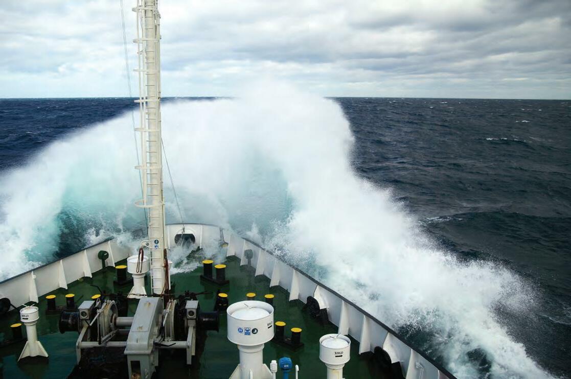


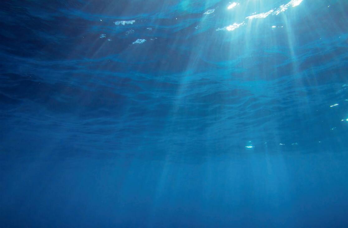
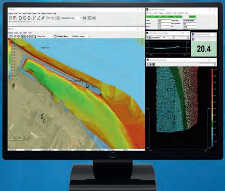


ANYWHEREONWATER, TRUSTYOURPOSITION Coastline Mapping Above and Below the Waterline Harbour Mapping Learnmoreaboutourproductsand solutionsfor hydrographicsurveying HYPACK® Surveying and processing software for Single Beam, Side Scan, ADCP, Sub-bottom, and Magnetometer systems. Your Sensors. Our Software. Survey The World. HYSWEEP® Surveying and processing software for Multibeam, Backscatter, and LiDAR systems. sales@hypack.com • www.h ypack2023.com DREDGEPACK® Dredging control software on Cutter Suction, Hopper, Excavator, Bucket Dredges, and more. HYPACK 2023 Training Event Panama City Beach, Florida January 9-12, 2023
Five Questions to…
Commander Gustavo Adolfo Gómez-Pimpollo Crespo, Spanish Navy Hydrographic Office (IHM)
Five questions on the state of the hydrographic industry
What do you see as the biggest challenges for the hydrographic industry as a whole in the coming years?
The hydrographic industry is in continuous evolution and has many, mainly technological, challenges ahead. The biggest challenge is the implementation of the S-100 product family (the new IHO hydrographic geospatial standard for marine data and information), as this requires coordination between the IHO, the industry involved in the development of the future electronic display and information system ECDIS (the new system that allows the visualization of ENCs in the new S-100 format) and hydrographic services.
Some national hydrographic services may require support from other agencies or ministerial departments for the development of products in the new format (e.g. ENC S-122 marine protected areas and ENC S-111 surface currents). IHM is already working to have the first ENCs in S-100 format ready for sale when the industry starts to use the new ECDIS. However, this also entails a digital transformation in the cartographic production line of hydrographic services (acquisition, data edition, quality control, storage, compilation, production and distribution), from the automation of workflows to big data management (volume, variety, velocity and veracity).
Looking at hydrography, which technological developments do you expect to be the main drivers in the coming years?
The main technological development in hydrography will be the use of AI in the cartographic production line (e.g. using AI to edit bathymetric data). Some companies have
already developed AI algorithms to edit bathymetric data, but these algorithms represent the first steps, and much more advanced algorithms will be achieved for use in hydrography, oceanography and geodesy, both in machine learning and deep learning.
AI will allow the collection of large amounts of bathymetric data by many vessels sailing with multibeam echosounders around the world. All this information will be stored in clouds for processing and integration into company or hydrographic services, most of whom will share the information for the General Bathymetric Chart of the Oceans (GEBCO).
Improving the resolution of our ocean data is necessary to improve the prediction of storm surges, tsunami models, and the efficient positioning of submarine cables, for example. Advances in the information derived from altimetric radars are therefore welcome.
Debate statement: “In ten years’ time, hydrographic surveyors will have been replaced by robotization and AI.” Do you: strongly agree, somewhat agree, neither agree nor disagree, somewhat disagree or strongly disagree? Please elucidate.
I am sure that robotization and AI will not replace hydrographic surveyors, as humans and machines are complementary. Robotization and AI will take jobs away from humans, but other jobs will be created for algorithm development, digital processing maintenance, control of uncrewed vessels, software maintenance, and so on.Take for example the CUBE algorithm invented by Brian Calder in 2003. The CUBE manual makes clear that the CUBE model is a bathymetric model that represents reality. The better the data acquired, the better the
bathymetric model is. Also, once the bathymetric model is obtained with CUBE, hydrographer supervision is always required to confirm or modify the bathymetric model where necessary.
Therefore, while a survey may be conducted by robotization and AI, the hydrographer will always have to supervise and correct the survey to ensure the safety of navigation. The hydrographer is however becoming increasingly versatile.
Which types of survey projects are paramount for your organization in the coming years?
We are working on several projects at IHM. These include:
- The replacement of the current hydrographic fleet (vessels more than 46 years old ) with a multidisciplinary oceanographic vessel (with the potential to develop hydrographic capabilities in any national or international scenario and capable of providing rapid environmental assistance (REA) and geospatial, meteorological and oceanographical (GEOMETOC) support), two coastal survey vessels and five hydrographic boats for work in shallow waters.
- The implementation of autonomous vessels.
Commander
Gómez-Pimpollo Crespo, hydrographic engineer and technical secretary of the Spanish Navy Hydrographic Office (IHM). Crespo has worked in hydrography since 2004, onboard various survey vessels (RV Tofiño, RV Rigel, RV Antares and RV Malaspina) and at IHM. He is now leading planning and documentation to replace the IHM hydrographic fleet in the coming years, and is a member of many national and IHO working groups. g.gomez-pimpollo@mde.es

37 Hydro INTERNATIONAL | BUSINESS GUIDE 2023 | INTERVIEW | HYDRO INTERNATIONAL
Gustavo Adolfo
Following the acquisition of USVs and UAVs this year, training personnel in their use and efficient editing of the data obtained is a priority.

- The validation and publication of the hydrographic vertical reference surface to harmonize and relate for the first time the terrestrial vertical reference (EGM 08-REDNAP global geoid model) to the nautical chart datum.

- Following the automation of the first phase of the integrated automatic system to provide hydrographic, meteorological and oceanographic support to amphibious operations, the development of the project’s second phase, which is its application to countermine operations and surface operations and support for the use of autonomous vessels.
How would you prioritize technology investments in your organization over the next couple of years?
IHM has a plan of replacement needs until 2030 for the equipment in the cartographic production line, from hydrographic and oceanographic equipment to the acquisition of state-of-the-art equipment. This plan is reviewed annually and according to available annual resources; material acquisition is carried out according to the order of priority of the equipment to be replaced or desired new equipment.
Lightweight Solution for UAVbased Coastal Mapping
The proven high-performance topo-bathymetric LiDAR scanner VQ-840-G is now offered in a new design. Maintaining the proven form factor, internal redesign and the additional use of lightweight structural components enable a weight reduction of 20 % to 9.8 kg (20 lbs). That makes the new VQ-840-GL Topo-Bathymetric
Fast & agile autonomous survey platform
Autonomous Surveyor is a 3.6 metre MANTAS T12 Autonomous Surface Vessel (ASV) mobilised with powerful integrated Hydroacoustic Survey System (iHSS) and expert field support. The combination of advanced systems and platform unlocks unprecedented speed, agility, and reliability. An incredibly lightweight solution with easy launch and recovery, Autonomous Surveyor offers complete deployment flexibility while overcoming the manoeuvring and speed limitations of manned survey vessels and standard USVs. Autonomous Surveyor is a next-generation solution for bathymetric survey, offering new levels of operator control flexibility, including full and semi-autonomous, and human-in-the-loop operations. With optional solar power, its open architecture and modular design allow rapid integration of new sensors and communication technologies to meet diverse project requirements.
4D Multibeam Solution for Underwater Construction, Dredging and Rock Dumping

Using conventional methods, acquiring an accurate depiction of the water bottom requires a survey vessel and crew to collect, process, and deliver hydrographic data while construction machinery and personnel standby. This process can be further hampered by weather conditions that exceed the survey vessel operating parameters or capacity limitations in survey equipment and personnel. NORdredge provides continuous real-time monitoring of the water bottom using a system mounted to the construction vessel, mitigating the schedule risk associated with conventional survey operations and delivering informative data to project personnel regardless of location.
TrueOcean Marine Data Platform (MDP)
The new TrueOcean MDP unlocks fast data management & sharing, digital map centric work, quality control and data processing while simplifying the scalability of marine engineering and construction projects on a global basis. Built for use by survey and energy companies, the MDP is based on cloud-agnostic technology that operates using cloud infrastructure from any provider, meaning data of any format can be worked on within the same dataspace by approved users from a modern web browser. The system fosters greater collaboration that unlocks information from data faster, while allowing it to be easily shared with contractors who depend on it to build marine infrastructure, including new wind farms.

38 | BUSINESS GUIDE 2023 | Hydro INTERNATIONAL
Airborne Laser Scanner even more suitable for UAV integration and UAV-based applications of combined topographic and bathymetric surveying in coastline and shallow water mapping as well as in river surveying.
HIGHLIGHTS
PRODUCT


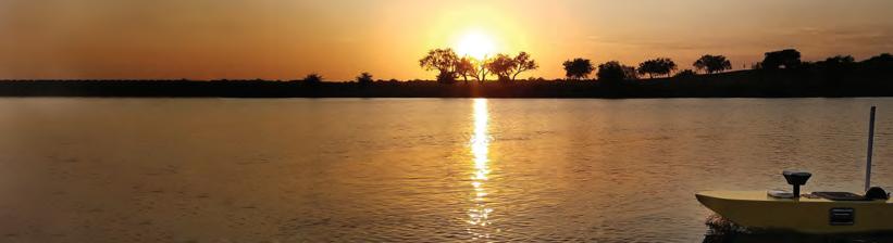
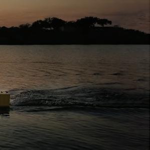


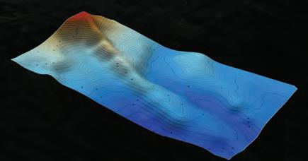
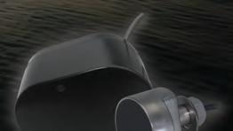


Talk with us about how EchoRange+ can integrate into your next survey project. AIRMAR.COM/ECHORANGE 30/200 kHz 200 kHz EchoRange™ Smart™ Sensors deliver depth and water temperature data to any NMEA device. EchoRange+ with Echo Envelope Option enables user-defined performance and echo waveform for bottom detection to 200 m. Compact and cost effective, with multiple mounting options, EchoRange+ is the most versatile line of field survey transducers available for autonomous hydrographic survey and fixed applications. Photo and 3D Bathyscape courtesy of SimpleUnmanned, LLC for Hydrographic Survey EchoRange_NavSurvey_HalfPg_HydroInternation_Dec2021.indd 1 10/28/21 10:58 AM Side Scan Sonar Sound Velocity Sensor & Profiler www.hydro-tech.cn 86-10-5727 5310 sales@hydro-tech.cn Greatly Enhance Sounding Accuracy
Five Questions to…
Dr M.D.E.K. GunathilakaFIG Commission 4
Five questions on the state of the hydrographic industry
What
Ocean-related industries are expected to grow substantially in the coming years and more people need to enter this field. Attracting and motivating the younger generation to join the profession is one of the challenges that we face, as many think it is hard work in a high-risk environment. Meanwhile, some drastic technological changes have taken place over the past decade or so, and the adoption of such technologies could lead to the creation of entirely new roles, making it necessary to integrate and reskill the displaced workers in the industry. However, the high cost of this could cause problems for some. Investment will probably drop slightly in the coming years, due to the global economic recession after the COVID-19 pandemic. We are already experiencing this in the construction sector, especially in developing countries.
Looking at hydrography, which technological developments do you expect to be the main drivers in the coming years?
Most of our sea area will be surveyed systematically, and some international initiatives are taking place in that direction, such as Seabed 2030 and the UN Ocean Decade. Over the past century, we have only managed to map a small portion of the ocean. There is therefore a massive area still to be mapped. For this, we have to use autonomous techniques to increase productivity, and multi-sensors to collect the bathymetry and the other ocean-related data simultaneously, to achieve cost-effective, more productive field operations. Extensive data processing will be mostly handled by real-time AI-based algorithms and in 3D reality/ reconstruction.
Debate statement: “In ten years’ time, hydrographic surveyors will have been replaced by robotization and AI.” Do you: strongly agree, somewhat agree, neither agree nor disagree, somewhat disagree or strongly disagree? Please elucidate.
I somewhat agree with this statement, although the role and tasks of surveyors will be reshaped or revolutionized rather than replaced. Instead of outdoors, we can expect more remote operations in operations rooms in an office or on a mother vessel. More autonomous systems such as AUVs and USVs will be used, and more AI will be used in data processing. However, the vital decisions will still be taken by hydrographers, in the planning stage, in data processing and in the final QA/QC. The conventional role of field data collection will shift to a more supervisory position. Ultimately, the surveyors’ role will be more managerial, which will increase productivity. Conventional subjects may become obsolete due to simple portable equipment and software applications that do not require much theoretical knowledge, so future surveyors will require more IT skills and an ability to operate and troubleshoot such systems. This transition will be more advanced in developed countries.
Which types of survey projects are paramount for your organization in the coming years?
My main involvement is in geomatics education. However, based on my involvement in the industry and various professional associations, I see two main types of projects. First, there will be more investment in the renewable energy sector, such as floating solar PV, near and offshore wind farms and tidal energy. Under the Paris Convention, all countries have agreed to reduce CO2 emissions by 50% by 2030.
Second, high-resolution bathymetric and oceanographic data are required for various coastal engineering and coastal resource management applications, as we look to the ocean for more resources. Our future survival will depend on the information we have on the ocean and how we utilize the ocean space.
How would you prioritize technology investments in your organization over the next couple of years?
Being an educator attached to a university, we aim to train competent graduates who can meet the needs of the industry as well as adapt to the future demands of the profession. As we know, the industry is rapidly adopting AI-based automated multi-sensory tools, and we therefore need to introduce our students to this. The universities must revise their curricula accordingly, and include theoretical concepts on AI and robotics as well as some practical aspects. We therefore need to prioritize our investments accordingly. Staff must be trained in these areas, and conventional bulky systems need to be replaced with more portable, compact units such as UAVs and USVs. The trend will be towards portable, shallow-water multibeam systems, as all coastal states are obliged to fulfil the latest IHO exclusive order for charting and global initiatives such as Seabed 2030.
Dr M.D.E.K. Gunathilaka is currently a senior lecturer at the Faculty of Geomatics, Sabaragamuwa University of Sri Lanka. He is programme coordinator for the BSc Hydrographic Surveying programme, which was awarded FIG/IHO/ICA Cat B recognition in 2015. Dr Gunathilaka will chair the FIG Commission 4 between 2023 and 2026. He is also a member of the Royal Institution of Chartered Surveyors (MRICS) and the Australasian Hydrographic Society.

41 Hydro INTERNATIONAL | BUSINESS GUIDE 2023 | INTERVIEW | HYDRO INTERNATIONAL
do you see as the biggest challenges for the hydrographic industry as a whole in the coming years?


 University of Southern Mississippi, 1020 Balch Boulevard, Stennis Space Center, MS 39529, Tel: +1 (228) 688-3177, marine.science@usm.edu, www.usm.edu
Five Questions to…
Dave Neff, Woolpert
Five questions on the state of the hydrographic industry
The biggest challenge is talent. Due to the current and foreseeable growth in the maritime marketplace, there is a high demand for talented hydrographic technicians and personnel that outweighs the supply. Hydrography is a complex profession requiring a myriad of skills, including sonar technicians, vessel captains, geodesists and data processing specialists, to name just a few. Additionally, technology advancements in the hydrographic industry are fast paced, requiring a dedicated talent pool to usher these innovations into existing workflows and effectively realize their efficiency gains. While there are many outstanding programmes across the country focused on different aspects of the profession, there is a growing need for a guided curriculum that programmes can adopt to best prepare students for a career in hydrography.
the coming years?
Sonar and processing software advancements
Hardware innovation typically drives software innovation. Each generation of sonar advancement allows hydrographers to acquire more data, at higher density and faster speeds. While these hardware advancements will allow for the scalability of data acquisition campaigns – collecting more data in less time – it will create a strain on data processing pipelines, forcing innovation of data management and processing software.
Telepresence and cloud-based solutions
The hydrographic industry will continue to benefit from the migration of all industries from the brick-and-mortar office paradigm to the virtual workforce. With the advancement of
cloud-based processing and data hosting technology, hydrographic professionals will be able to move large amounts of geospatial data through modern data pipelines at a much faster pace. These advancements will foster a scalable, real-time connection between acquisition teams and processing teams.
Autonomous vessels
While autonomous survey vessels are effective in several hydrographic applications, broad adoption across the maritime industry has a long way to go. Vessel capability, situational awareness and maritime regulations are just a few of the challenges ahead of this technology.
Debate statement: “In ten years’ time, hydrographic surveyors will have been replaced by robotization and AI.” Do you: strongly agree, somewhat agree, neither agree nor disagree, somewhat disagree or strongly disagree? Please elucidate.

I strongly disagree with this statement. As autonomous vessel providers enter the hydrographic space, jobs are being created rather than lost. Conceptually, as autonomous survey craft are adopted into large-scale mapping projects, the need for certain vessel-based skills will decrease, while the need for others will increase. While autonomous vessels can be compelling tools for mapping campaigns, they still need to be cared for by humans. This care includes monitoring, maintenance and fleet management, to name a few examples. Additionally, autonomous vessels will add scalability.
As these new tools bring efficiency to acquisition efforts, they will enable larger amounts of data to be collected at lower costs than traditional shipborne campaigns. This increase in acquisition efficiency will result in a need for
professionals.
Which types of survey projects are paramount for your organization in the coming years?
Large-scale coastal mapping programmes are of great interest. Considering the effects of the changing environment (i.e. sea-level rise, increasing storm severity, etc.), understanding the depths and dynamics of our coastal environments is paramount for the challenges ahead. Also, marine-based renewable energy is a developing market space. As more investment is being made in offshore wind energy, wave energy and other marine-based renewable technologies, the hydrographic survey industry will play a critical part in advancing the space.
How would you prioritize technology investments in your organization over the next couple of years?
As technology leaders in the hydrographic industry, we are constantly looking to innovate our workflows through several avenues. Sensor development and adoption is a key strategy. As the next generation of multibeam sonars and topobathy Lidar sensors are developed and released, we will be early adopters. These sensor advancements will allow our group to collect data at higher densities and higher speeds, adding efficiency to our programmes and value for our clients.
Dave Neff is an ACSM-certified hydrographer and geospatial programme director at Woolpert. Neff has managed hydrographic projects across the US and internationally, and has extensive experience in project management, vessel mobilization, survey planning, data collection and processing, report writing, business development and product generation.
43 Hydro INTERNATIONAL | BUSINESS GUIDE 2023 | INTERVIEW | HYDRO INTERNATIONAL
What do you see as the biggest challenges for the hydrographic industry as a whole in the coming years?
Looking at hydrography, which technological developments do you expect to be the main drivers in
AIRMAR Technology Corporation
AIRMAR Technology pushes the boundaries of ultrasonic technology to develop advanced products that withstand the harshest ocean environments while reliably facilitating data gathering from surface to full ocean depth. Our comprehensive suites of oceanographic and survey transducers, plus our IPX7-rated WeatherStation instruments, deliver performance that meets the most challenging mission requirements.
SENSING THROUGH WATER
AIRMAR offers a comprehensive line of transducers for hydrographic survey and underwater scientific applications, including models suitable for shallow- and deep-water surveying, sub-bottom
profiling, navigation, fisheries research and aquatic habitat assessment. Customization of transducers for specific marine applications is also available.
SENSING WEATHER
AIRMAR also offers ultrasonic WeatherStation instruments for ASVs, buoys, offshore monitoring platforms, and more. Developed with an IPX7 rating, along with other features that meet the operational challenges faced at sea, our rugged instruments are trusted to deliver proven performance under the toughest conditions.
ECHORANGE SMART SENSORS
AIRMAR’s ultrasonic EchoRange Smart Sensors
deliver depth and water temperature data to any NMEA device. With embedded transceivers and sophisticated digital signal processing, they are ideal for applications such as hydrographic surveys, ASVs, UUVs and inspection.
Our next-level EchoRange+ with Echo Envelope Option enables user-defined depth range and echo waveform for bottom detection to 200m. Compact and cost effective, with multiple mounting options, EchoRange+ is the most versatile line of field survey transducers available for autonomous hydrographic surveys and fixed applications.
CHC Navigation
CHC NAVIGATION AT A GLANCE
CHC Navigation (CHCNAV) is a publicly listed company creating innovative GNSS navigation and positioning solutions. With a global presence across the world and distributors in over 100 countries, and more than 1,300 employees, CHCNAV is today recognized as one of the fastest-growing companies in geomatics technologies.
FROM GNSS SURVEY TO MARINE CONSTRUCTION
CHCNAV develops advanced geospatial technologies and provides a wide range of state-of-the-art solutions for land surveying, construction, GIS,
hydrography and bathymetric survey, deformation monitoring, precision farming and 3D mobile mapping for mass data acquisition.
OUR MARINE SURVEY SOLUTIONS
The Apache series consists of several integrated marine drone solutions for conducting bathymetric surveys, high-resolution hydrographic projects, current profiling and water sampling in a fully autonomous manner. The Apache 3 is an unmanned portable vessel that provides a cost-effective solution for conducting single-beam bathymetric surveys. The Apache 4 is specifically designed for marine current profiling and is
compatible with all major ADCP brands. The Apache 6 is a USV design for high-resolution hydrographic surveys with integrated Norbit™ multibeam echo sounders.
MAKE YOUR WORK MORE EFFICIENT
The CHCNAV slogan perfectly summarizes the way our GNSS positioning and integrated navigation solutions are designed to dramatically improve productivity and provide an outstanding return on investment for our customers and business partners.
CHC Navigation | www.chcnav.com | +86 21 5426 0273 | marketing@chcnav.com
Deep
Deep is a survey company founded in 1999 and based in Amsterdam, specializing in hydrography, marine geophysics and offshore precise positioning. Deep’s areas of operation include offshore, coastal zones, seaports and inshore waterways. “Our goal is to support the sustainable blue economy and
climate adaptation projects by providing our customers with high-quality hydrospatial data. Working with us means working with a highly skilled and international workforce that deploys high-quality and innovative equipment, ranging from fully crewed to uncrewed vessels. Our people are attracted by our
focus on the latest science and technology as well as our down-to-earth, hands-on culture. We fully embrace new technologies, enabling us to automate and robotize. We get the job done.
| BUSINESS GUIDE 2023 | Hydro INTERNATIONAL 44
AIRMAR Technology Corporation | www.airmar.com | +1 (603) 673-9570 | sales@airmar.com
Deep BV | www.deepbv.nl | +31 (0)20 6343676 | info@deepbv.nl
EvoLogics
EvoLogics is an innovative high-tech enterprise with headquarters in Berlin, Germany.

The company launched in 2000 with a strong group of scientists and R&D experts and aims to develop innovative technologies for maritime and offshore industries.
EvoLogics creates high-end solutions for underwater smart robotics, sensor systems, acoustic
communication and positioning networks. These combine state-of-the-art engineering with bionic concepts.
Research and innovation are the cornerstones of EvoLogics, and an underwater Internet of Things that enables intelligent cooperation between various vehicles and sensors has been the main vector of EvoLogics development strategy.
Smart underwater networks build on EvoLogics’ S2C spread-spectrum communication technology that combines underwater acoustic data networks with integrated real-time positioning. Together with advanced sensor systems, AI-based object recognition and analytics, as well as autonomous underwater and surface vehicles for survey and support operations, EvoLogics creates highly capable underwater solutions, even in complex mission scenarios.
| www.evologics.de | +49 30 4679 862-0 | sales@evologics.de
Exail
Exail is a leading high-tech industrial group specializing in cutting-edge robotics, maritime, navigation, aerospace and photonics technologies. With a strong entrepreneurial culture, Exail delivers unrivalled performance, reliability and safety to its civil and defence clients operating in severe environments. From the deep sea to outer space,
Exail expands their capabilities with a full range of robust in-house manufactured components, products and systems. Employing a workforce of 1,500 people worldwide, the group benefits from a global footprint and conducts its business in over 80 countries.
Exail was formed by ECA Group and iXblue joining forces in 2022. It is a subsidiary of Groupe Gorgé, a family-owned company specialized in hightechnology.
Exail | www.exail.com
Falmouth Scientific
Falmouth Scientific, Inc. (FSI) provides innovative and reliable sensor and survey solutions for applications in saltwater and freshwater environments. FSI’s sensor-based standard product areas include advanced seismic, sub-bottom and sidescan sonar imaging systems; current, wave and tide meters; electroacoustic transducers; and acoustic relocation systems. Services include the
custom design, development, integration and production of transducers and marine technology, and value-added services such as prototyping, product assembly, potting, calibration and pressure testing.
At FSI’s core is innovative system and design engineering, on-site assembly and production operations and electrical, acoustic, environmental
and system testing facilities. FSI was founded in 1989 based on WHOI technology licenses, and is located in the heart of the New England marine technology cluster on Cape Cod in Pocasset, Massachusetts.

Hegg Marine Solutions is a brand of FSI products for seismic sources, sub-bottom and sidescan sonar system technologies and field support services.
Scientific | www.falmouth.com | +1 (508) 564-7640 | sales@falmouth.com
Hydro INTERNATIONAL | BUSINESS GUIDE 2023 | 45
EvoLogics
Falmouth
Hydro-Tech
MAKING UNDERWATER EXPLORATION EASIER
With a focus on acoustic sounding technology, Hydro-Tech has developed products that have been widely applied in the underwater exploration industry. Today, Hydro-Tech develops fully independent and controllable core technologies in hydrographic surveying and remains committed to continued iterative innovation.

MAJOR PRODUCTS
Based on these years of technology accumulation,
Hydro-Tech cannot only develop, but also manufacture, full series of sonar products and related auxiliary devices, including MS400P, MS400U and MS8200 multibeam echosounders; SS3060, SS900F and ES Series sidescan sonars; and SVS1500 and SVP1500 sound velocity sensors and profilers.
All Hydro-Tech products show great performance and high quality, which is how we win our customers’ loyalty and so many industry awards. We
Hydro-Tech
HYPACK
HYPACK, a Xylem brand, has been developing HYPACK, HYSWEEP and DREDGEPACK software solutions since 1984. With over 30 years of experience, and over 10,000 users, HYPACK is a leading provider of hydrographic and dredging software worldwide, supporting over 400 different sensors and devices.
HYPACK provides simple-to-use tools to design your survey, acquire and process your data, and create the required final products. HYPACK provides all you need for single beam, sidescan, magnetometer and sub-bottom surveys. Powerful 64-bit editing tools enable you to quickly review and clean your data in preparation for your final output. Modules to create
electronic navigational charts, calculate volumes and generate DXF contours and sidescan mosaics are all part of the package.
HYSWEEP is the add-on module for calibration, data collection and processing for your multibeam sonar and Lidar systems. Supporting nearly all multibeam sonars on the market, you can acquire backscatter, intensity and water column simultaneously with bathymetry. Online real-time CLOUD displays show the system in operation. In the 64-bit HYSWEEP EDITOR, process large datasets efficiently, analysing your data with CUBE, Wobble Analysis and Beam Angle Test. Grid your data and calculate your output for your project requirements: average, mode,
are very proud that Hydro-Tech sonars occupy the leading market share in China.
TAILOR-MADE CAPABILITY
Besides delivering standard products, we can also take advantage of our strong R&D know-how and hydrographic expertise to provide an attentive consulting service, customized products or one-stop solutions for special project requirements.
Innomar

INNOMAR provides parametric sub-bottom profilers and associated software that are perfectly suited for high-resolution sub-seabed visualization in water

depths from less than one metre to full ocean depth. Applications include, but are not limited to, dredging, geological surveys, mapping of buried
median, standard deviation and more. Export to ASCII XYZ, LAS, matrix files and other custom formats.
DREDGEPACK enables you to monitor and track digging operations for all dredge types.
DREDGEPACK monitors the position and depth of the cutting tool in real time and re-maps the bottom based on the depth and location of the digging tool. The colour-coded depth information is displayed in plan and profile views to show the ‘As Surveyed’ and ‘As Dredged’ depths for millions of cells. This enables you to maximize digging efficiency and precision to reduce the risk of dredging errors and provide a record of digging operations.
pipelines, cables and UXO or reconnaissance and route surveys at prospective offshore building sites, such as wind farms.
| BUSINESS GUIDE 2023 | Hydro INTERNATIONAL 46
HYPACK - A Xylem Brand | www.hypack.com | + 1-860-635-1500 | sales@hypack.com
| www.innomar.com | +49 381 44079 0 |
Innomar Technologie
info@innomar.com
| www.hydro-tech.cn/en/ | +86 10 5727 5310 | kn.xu@hydro-tech.cn
Kongsberg Maritime

Kongsberg Maritime is the largest marine technology organization in the world. Its matchless portfolio of integrated, next-generation products and services, supported by a network of expert staff in 117 international locations, enables the company to provide a ‘full picture’ single supplier solution to meet every customer requirement across the merchant, offshore, subsea and naval sectors, from upgrades to newbuilds. Kongsberg Maritime’s comprehensive array of cutting-edge automation, power, propulsion, navigation and dynamic positioning systems, bolstered with an abundance of specialist engineering skills and experienced technical insights, covers all aspects of vessel
design, construction and operation from concept and commissioning onwards, encompassing a vessel’s complete working life. Committed to environmental responsibility, Kongsberg Maritime is driving the digital transformation of the maritime industry, enabling the practical application of sustainable ocean policies which meet IMO emission reduction targets. Kongsberg’s innovative electric and hybrid power solutions, its offshore training simulators, its development of advanced remote operation and autonomous systems plus its cultivation of IoT platforms capable of integrating and leveraging big data are all designed to enhance energy efficiency,
operational safety, reliability and value. Kongsberg Maritime’s portfolio accommodates other clean energy initiatives such as hydroacoustic solutions to facilitate offshore wind turbine installation, operation and maintenance. Beneath the surface, its products range from marine robotics, subsea monitoring and subsea mapping & positioning systems through to integrated drilling units, aquaculture solutions and underwater cameras. Kongsberg’s vessel-to-cloud data infrastructure system, Vessel Insight, allows operators to easily access and interpret fleet-wide vessel data, conduct trend analysis and supervise communications, all from a single web interface.
Leica Geosystems
SUPERIOR AIRBORNE BATHYMETRIC LIDAR SENSOR
Leica Geosystems’ airborne bathymetric sensor
Leica Chiroptera-5 combines topographic and bathymetric Lidar channels with a four-band camera to deliver seamless data from water to land. The system provides 40% higher point density, a 20% increase in water depth penetration and improved topographic sensitivity compared to previous generations. The high-performance airborne sensor delivers detailed Lidar data of submerged terrain and objects and supports numerous applications, such
as nautical charting, erosion risk assessment, environmental monitoring and seabed classification.
INCREASED PRODUCTIVITY
The superior sensor performance of the Leica Chiroptera-5 allows to collect more data and capture larger areas with greater detail. The system is designed to address the growing need to collect high-accuracy data for environmental monitoring and surveying of shallow-water regions. Combined with the Leica HawkEye deep bathymetric module, Chiroptera-5 offers unmatched
capabilities in deep waters, covering the full bathymetric range.
HIGH-PERFORMANCE PROCESSING WORKFLOW
The LSS end-to-end data processing workflow provides full waveform analysis and automatic calibration, refraction correction and turbid water enhancement. The workflow offers near real-time data processing, enabling coverage analysis immediately after landing and allowing operators to QC the data quickly before demobilizing the system.
MacArtney
The MacArtney Group is a global supplier of underwater technology solutions specializing in the design, manufacture, sale and service of a wide range of solutions to offshore industry operators, ROV, diving and subsea surveyors, the renewable energy sector, ocean science institutes, maritime civil engineering industries and navies across the world.
MacArtney offers a wide range of advanced and reliable products and system solutions, from subsea cables and connectors to state-of-the-art integrated packages, including fibre optic telemetry, underwater cameras and lights, oceanographic instruments,

marine winch systems and remotely operated, towed vehicles.
All products supplied are designed and tested to provide high quality, efficiency and reliable performance in the challenging underwater environment.
The highly skilled and experienced staff form the best basis for the supplied services and products. MacArtney aims to be accessible around the world and around the clock. ‘Global access to local support’ is a mantra recurring throughout the entire organization at all locations.
MacArtney is a privately owned corporation established in 1978 with group headquarters in Esbjerg (DK). The MacArtney Group also reside in Aberdeen (UK), Stavanger (NO), Mölnlycke (SE), Aix-en-Provence (FR), Bologna (IT), Rotterdam (NL), Kiel (DE), Bremen (DE), Houston, Boston and San Diego (US), Victoria and Dartmouth (CA), Rio de Janeiro (BR), Mumbai (IN/UAE), Perth (AU), Ningbo (CN) and Singapore (SG).
Moreover, MacArtney operates an extensive network of 20 representatives and distributors across every continent. This way, MacArtney products are available locally – with global 24/7 support.
MacArtney A/S | www.macartney.com | +45 7613 2000 | info@macartney.com
Hydro INTERNATIONAL | BUSINESS GUIDE 2023 | 47
Leica Geosystems, part of Hexagon | www.leica-geosystems.com/chiroptera-5 | +46 361 966 80 | info.gsd@leica-geosystems.com
Kongsberg Maritime | www.kongsberg.com | +47 32 28 5000 | km.sales@kongsberg.com
NORBIT Subsea
NORBIT Subsea designs and develops wideband multibeam sonars for hydrographic applications, forward-looking applications and advanced subsea leakage detection. Our solutions are based on the latest in analogue and digital signal processing and
our products provide wide coverage monitoring combined with high sensitivity and accuracy. NORBIT Subsea is part of the NORBIT Group, an industrial corporation with companies in SubSea, Intelligent Traffic Systems and Original Design
Manufacturing of industrial electronics. Our engineers have pioneered groundbreaking innovations within monitoring, instrumentation, telemetry and communication solutions for harsh environments.
NORBIT Subsea | www.norbit.com/subsea/ | +47 73 98 25 50 | subsea@norbit.com
Nortek
Nortek designs, develops and produces scientific instruments that apply the Doppler principle to underwater acoustics to measure movement under water. These instruments can be used to measure processes such as currents and waves or to help subsea vehicles navigate.
Backed by our global support team, our ADCPs and DVLs are used by scientists, researchers and
engineers at renowned institutions, government agencies and pioneering robotics companies worldwide. They are employed in demanding environments that require state-of-the-art instrumentation that is reliable and easy to use.
Nortek’s scientific product portfolio is capable of measuring everything from small-scale turbulence to full-ocean current profiles. Our navigational aids
bring vehicles safely and reliably to great depths under challenging conditions.
Our objective is to excite users with useful, innovative technology that is certified by leading quality assurance organizations.
Nortek | www.nortekgroup.com | +47 67 17 45 00 | inquiry@nortekgroup.com


OceanAlpha Group Ltd.

OceanAlpha Group Ltd. is the world’s leading commercial USV company. It has grown from a single small office in 2010 to a workforce of over 626 employees today, with more than 214 R&D engineers and 402 USV-related patents.
To help humans get closer to the ocean at a lower cost and with higher efficiency and enhanced safety, OceanAlpha is serving professionals in various fields with integrated USV solutions. Its advanced products are redefining data acquisition, auto-piloting and security and rescue services in the marine sector.
OceanAlpha’s business includes inland & offshore surveying, environmental monitoring, marine engineering, security & rescue, transportation and recreation. The company operates in more than 50 countries worldwide.
OceanAlpha | www.oceanalpha.com | +86 756 2592836 | sales@oceanalpha.com
PyroScience
PyroScience is one of the world’s leading manufacturers of state-of-the-art optical pH, oxygen and temperature sensor technology for industrial and scientific applications, in particular in the growth markets of environment, life science, biotechnology and medical technology. The application areas range from deep-sea research to space exploration.
PyroScience offers innovative sensor concepts with expert customer support to the worldwide research and industrial community, NGOs and governmental organizations. These include several optical meters for diverse analytes (e.g. oxygen, pH, temperature) and a broad range of optical sensor heads based on proprietary REDFLASH technology. All instruments
and sensor heads are developed, designed and produced in-house.
PyroScience has transformed its expertise in innovative lab sensor solutions towards a flexible underwater sensor platform and recently launched a unique all-in-one optical sensor technology for advanced underwater applications.
PyroScience | www.pyroscience.com | +49 241 5183 2210 | info@pyroscience.com
| BUSINESS GUIDE 2023 | Hydro INTERNATIONAL 48
RIEGL – Topo-bathymetric Airborne Laser Scanners and Systems
RIEGL is an international leading provider of cutting-edge Waveform-Lidar technology for applications in surveying.


For combined topographic and bathymetric surveying, RIEGL offers the fully integrated airborne laser scanning systems VQ-880-G II and VQ-880-GH, ideally suited for coastline and shallow water mapping, river bed profiling, measurement of
aggradation zones, and so on. These turnkey surveying systems include a high-end IMU/GNSS unit, up to two high-resolution cameras, and an integrated infrared laser scanner to support the detection of the water surface.
Additionally, the RIEGL VQ-840-G and the new RIEGL VQ-840-GL Topo-bathymetric Airborne Laser Scanners are offered for coastline mapping and river survey. They
| www.riegl.com | +43 2982 4211 | office@riegl.com
SBG Systems
SBG Systems designs and manufactures compact, high-performance and cost-effective inertial motion sensing solutions. Our motion sensors and inertial navigation systems are ideal for hydrographic applications, ship motion monitoring, Lidar and buoy orientation and positioning, ROV & AUV control, camera stabilization and antenna tracking.
FASTEST, MOST INTUITIVE POSTPROCESSING SOFTWARE, IDEAL FOR ALL MARINE SURVEYORS’ PROJECTS
This software, called Qinertia, gives access to offline RTK corrections from more than 8,000 base stations located in 164 countries. Trajectory and orientation
are greatly improved by processing inertial data and raw GNSS observables in forward and backward directions.
Qinertia supports third-party IMUs and all GNSS receivers, and covers all surveyors’ projects with its new GNSS license to post-process both static and kinematic GNSS data.
It now includes a brand new Virtual Base Stations (VBS) feature. The VBS computes a virtual network around your project in which position accuracy is maximized, homogeneous and robust, as for PPK short baseline. Surveyors can collect data far from base stations or over large areas, making it ideal for corridor mapping.
provide more than two Secchi depths water penetration and provide high spatial resolution due to a measurement rate of up to 200kHz and selectable laser beam divergence. At just 9.8kg (20lbs), the VQ-840-GL is ideally suited for UAV integration.
ALL-IN-ONE SOLUTION DEDICATED TO HYDROGRAPHIC SURVEYING IN ALL CONDITIONS
Highly versatile, the Navsight Marine Solution comes as a motion reference unit (MRU) – providing roll, pitch and heave – or as a full navigation solution with embedded tri-frequency GNSS receiver, or using an external GNSS receiver. Navsight INS offers continuous positioning in all conditions, such as surveying under a bridge or during GNSS outages due to coastal infrastructures (buildings, harbour cranes, etc.).
Systems S.A.S. | www.sbg-systems.com | +33 1 80 88 45 00 | sales@sbg-systems.com
Seabed
Seabed (founded in 2004 and based in Amsterdam, the Netherlands) is specialized in high-quality equipment for surveying and dredging. Our team of highly qualified engineers, surveyors and sales persons develop, produce and sell products for the offshore and onshore industry.
With our complete team of developers, support engineers, hydrographic surveyors and sales operatives, we aim for the right balance in sales, support and engineering, and are specialized in out-of-the-box solutions. This, together with dealerships of well-known global brands offering
equipment of a very high standard, makes Seabed a reliable partner for all your needs. Our strength lies in finding the most suitable solution for every requirement by using existing equipment and by system integration to fulfil the client’s needs. Our team can provide support for every step of the process, including installation and training. We offer the following products: positioning solutions, sonar/bathymetry, unmanned surface vessels, autonomous underwater vehicles, mobile mapping, underwater sensors, moving vessel profilers, hydrophones, density probes, subsea cameras, DVL,
bottom sampling, crane systems, software solutions, telemetric solutions and cables, and connectors and housing.
All these products are also available for rental. We are expanding our rental pool continuously to keep up with changes in technology.
Interested? Seabed organizes demo days yearly in September, where all the latest equipment is demonstrated. If you wish to attend, please email us at rsvp@seabed.nl. For more information, check out our Seabed Gazette.
Hydro INTERNATIONAL | BUSINESS GUIDE 2023 | 49
RIEGL
SBG
Seabed | www.seabed.nl | +31 20 6368443 | sales@seabed.nl
Sensor Technology
Sensor Technology Ltd. is your proven OEM partner for underwater acoustics. Our commitment is to design and deliver products tuned to our clients’ platforms for operational success. Throughout our 39-year history, Sensor Technology Ltd. has specialized in providing our clientele with innovative customized solutions with repeatable results, which has propelled us to become a global leader in piezoelectric-based acoustic tools.
Sensor Technology is a proudly Canadian company
with an international customer base. In fact, 70% of our product is shipped internationally. Our vast experience with export regulations and requirements allows us to be a strategic partner in both dual-use and controlled goods. Our products are used primarily in the defence, energy, aquaculture, oceanographic and hydrographic industry sectors.
Our past success has been accredited to our adhering to our three core values: Innovation – founded on research and design,
Sensor Technology continues to focus to provide effective solutions for our clients.
Knowledge – with almost 40 years of experience in the marketplace, clients can capitalize on past learnings and expertise to offer effective solutions. Customization – our hallmark is bespoke solutions. Our strength is to understand and offer innovative products that fit each unique need. We pride ourselves on our ability to adapt and evolve with ever-changing demands in the industry.
Sensor technology | www.sensortechcanada.com | +1 705 444 1440 | techsupport@sensortechcanada.com
Subsea Europe Services

With an extensive portfolio of technology, services and expertise designed to help every organisation collect and evaluate marine data on their own terms, Subsea Europe Services GmbH makes it easy to access and use precision sensors and equipment, complete survey systems, cutting-edge unmanned and autonomous platforms and innovative, unifying solutions.
The company’s unique ‘sensors, systems, solutions’ capability is enabled through partnerships with leading technology innovators including AML Oceanographics, BeamworX, BeeX, MARTAC, R2Sonic, Seatronics and Sonardyne. Subsea Europe Services also provides a unique autonomous vehicle fleet for customer campaigns, which includes the high-speed Autonomous Surveyor USV for marine data acquisition,
and the state-of-the-art hovering AUV A.IKANBILIS, for underwater inspection applications. While serving a diverse customer base, from offshore wind farms owners and contractors to hydrographic survey companies, government organisations and research institutes, Subsea Europe Services continues to create new developments that simplify and automate the collection of marine data.
Teledyne Geospatial

Teledyne Optech and Teledyne CARIS have united to form the new Teledyne Geospatial, offering holistic solutions to seamlessly map land and sea through the integration of industry-leading Lidar sensors and
world-renowned software workflows. This collaboration empowers customers with a competitive edge in mapping and delivering data products inside one complete workflow. Ease of
Teledyne Marine – A Sea of Solutions
Teledyne Marine is an organization comprised of 23 leading-edge undersea technology brands that have been assembled by Teledyne Technologies Inc. Through acquisitions and collaboration, Teledyne Marine has evolved into an industry powerhouse, providing the widest breadth of marine technology in the industry, now available through a single supplier.
Each Teledyne Marine brand is a leader in its respective field, with a shared commitment to providing premium products backed by unparalleled service and support.
With technologies divided into five core segments; imaging, instruments, interconnect, seismic and
collection and processing through to final products is enhanced with efficiency-driving AI noise classifying algorithms and real-time quality control.
vehicles, Teledyne Marine sales staff can address not only brand level solutions but also turn-key, customized systems that leverage our full range of technology. Our goal is to provide one-stop purchasing capability, worldwide customer support and the technical expertise to solve your toughest challenges.
Teledyne Marine | www.teledynemarine.com | info@teledynemarine.com
| BUSINESS GUIDE 2023 | Hydro INTERNATIONAL 50
Teledyne
Geospatial | www.teledynegeospatial.com | +1 905 6600 808 | VAU_inquiries@teledyneoptech.com
Subsea Europe Services | www.subsea-europe.com | +49 40 30700784 | surveyready@subsea-europe.com
Terradepth
Terradepth is an ocean data-as-a-service company focused on scaling ocean data collection and dissemination, enabling unprecedented exploration of the underwater environment. Their unique end-to-end solutions increase maritime operational efficiency with geophysical survey services and innovative ocean data management and their
visualization solution, Absolute Ocean (AO), is empowering the marine industry with deeper insights that support better decision-making. Terradepth offers seafloor hydrographic and geophysical survey solutions through a fleet of autonomous underwater vehicles enabling cost-effective, high-resolution data collection. Their
survey solutions are an efficient alternative to traditional survey and monitoring operations and are available to support global operations for the maritime domain. Their highly configurable and versatile platforms remove the need for continuous human supervision during ocean data collection operations.
Terradepth | www.terradepth.com | 844.982.3282 | contact@terradepth.com


Trimble Applanix
Trimble Applanix designs, builds, delivers and supports products and solutions designed specifically for the hydrographic survey industry. Our products and solutions provide robust, reliable and repeatable positioning and motion compensation solutions for vessels. With over 20 years of established leadership in the marine sector, Applanix POS MV has become the industry standard in positioning for hydrographic vessels. Georeferencing data generated from multibeam sonar technology using the GNSSaided inertial positioning system POS MV
produces the most advanced and accurate solution for mapping the seafloor. POS MV products are optimized for marine applications, incorporating technology such as TrueHeave™. POS MV can be installed on dedicated survey vessels or deployed on vessels of opportunity for ad hoc survey tasks, covering a variety of applications including seafloor mapping, harbour mapping and coastline mapping above and below the waterline. Applanix POSPac MMS for marine is powerful post-mission software for processing sensor data from your POS MV for highly accurate
and robust direct georeferencing. Optimized for the marine environment and compatible with a wide variety of hydrographic processing packages, this software solution achieves both maximum accuracy and maximum efficiency for the direct georeferencing of survey data. Trimble’s Applanix marine positioning solutions offer a complete hardware and software integrated solution with industry-leading global support, lowered deployment costs, faster times to completion and improved data quality. Anywhere on water, trust your position with Applanix.
TrueOcean
Subsea geo-information specialist TrueOcean GmbH is the company behind a cutting-edge secure Marine Digital Platform (MDP), which has been created to accelerate the transformation of data acquired by diverse underwater sensors during marine surveys – including multibeam echosounders and related systems from any manufacturer – into actionable, easily shared information and insight via the cloud.
TrueOcean’s aim is to digitize the ocean to support the shift towards sustainable maritime economic solutions, especially in the context of optimizing the entire marine data acquisition workflow so that survey companies are equipped to exploit extensive new opportunities generated by the global growth in offshore wind production capacity.
The company’s cloud-agnostic technologies address current and future challenges including streamlining the journey of data from ping to cloud, ensuring data sovereignty and security, and providing global access to approved stakeholders regardless of any national restrictions and without the need for specialist applications to work with data in diverse formats.
Hydro INTERNATIONAL | BUSINESS GUIDE 2023 | 51
TrueOcean | www.trueocean.io | +49 (0)431 363 056-0 | info@trueocean.io
Applanix Corporation | www.applanix.com | +1 905 709 4600 | marine@applanix.com
Valeport
Valeport provides leading-edge marine sensing and monitoring solutions. We are a British manufacturer of hydrographic, oceanographic and hydrometric instrumentation, which includes bathymetry, CTD & environmental, current, sound velocity and tide gauges.
Valeport has supplied the subsea sector for over 50 years, supporting hydrographic surveys with a comprehensive portfolio of products that deliver highly innovative solutions.
Valeport’s SWiFT profiler range enables highly accurate measurements to be easily and conveniently gathered. Combining sensors for multiple profiles in a single drop and a seamless data transfer for instant use, the SWiFT range has ease of use at its core. Sensors blend Bluetooth connectivity, rechargeable batteries and GPS to deliver the highest quality data. New additions to the SWiFT family – the SWiFT CTDplus Turbidity and SWiFT CTDplus Chlorophyll a – deliver direct CTD measurements with turbidity or chlorophyll a observations.
Bathy2, a new integrated sensor suite designed for those requiring bathymetric data from ROVs, underwater vehicles or drop structures, brings together benefits of density-corrected sound velocity density output alongside interchangeable pressure modules to offer enhanced accuracy at varying depths.
Valeport technology is used worldwide by subsea, hydrographic, hydrometric, metrological & positioning, oceanographic, ports, harbours & dredging, renewable energy and scientific research organizations.

Valeport Ltd | www.valeport.co.uk | +44 (0) 1803 869292 | sales@valeport.co.uk
Woolpert
Woolpert sports an innovative and agile team of certified hydrographers, professional land surveyors and GIS professionals. This industry-leading crew develops and integrates topographic, bathymetric and hydrographic technologies to provide clients and the industry with the data, analyses and modelling needed to successfully advance critical projects and initiatives.
Woolpert’s full-service geospatial capabilities complement its expansive maritime services, which

include elevation-derived hydrography, dredging and marine construction support, seafloor mapping, emergency response, reservoir capacity surveys, tidal and river current surveys, tidal gauge analyses, cable and pipeline alignment, geodetic and geophysical surveys, environmental mapping and remediation, marine GIS, object detection and more.
By owning and operating fleets of survey vessels and manned and unmanned aircraft, which are customized to carry latest-generation sensors and
equipment, Woolpert enables immediate and proficient mobilization. This responsive structure and leadership supports the expert collection of high-accuracy topographic and bathymetric Lidar data, multibeam and sidescan sonar data and high-resolution imagery, which are required by public, private and governmental agencies around the world.
Woolpert | www.woolpert.com | 800-414-1045 | kim.hansen@woolpert.com
Climate Change and the Energy Transition in the Hydrographic Industry
Climate change is having a significant impact on the hydrographic industry, and many organizations are taking steps to reduce emissions and minimize their environmental footprints. Such steps include using more efficient equipment, reducing energy consumption and implementing sustainable operational practices. These efforts are set to continue, while new ways of reducing our carbon emissions are explored and take shape. Here, Patrick Reyntjens, CEO and founder of GEOxyz – a leading service provider focusing on marine surveys and offshore renewable support activities – sheds light on his vision and ambition.

How does climate change affect your business? (This is broader than carbon neutral; the question can also be answered from the business context). Our people at GEOxyz have a passion for the sea and a strong bond with water and the natural environment. As a service provider, we support our customers in realizing their energy transition goals. In our EU home market and the USA, governments have set clear targets for the energy transition, with an important role for offshore wind energy. We service our clients during the different phases of the life cycle of offshore wind farms (OWFs), by providing site characterization with an aim to deliver insights into the construction risks and status of the future OWF. We provide transfer services of goods and personnel and carry out inspection and maintenance services for OWFs. As OWF initiatives are booming, we are receiving a lot of requests and, to keep up with this demand, GEOxyz has expanded its green fleet.
In April last year, we launched our second hybrid-powered vessel: the Geo Ocean VI. As a result, 50% of our ocean vessels is now hybrid. This means that the carbon emissions per offshore mile are well below the average conventional offshore service vessel. These vessels are also designed to see their engines and battery systems changed over their lifetime, in recognition of the fact that propulsion technology will change before the hull and vessel structure reach the end of their economic lifetimes. Hydrogen can be used as source to power our electrical engines.
Climate change is actually helping our industry and business to grow. This means that our industry does not just face challenges such as the war for talent seen in every growth sector, but also some specific challenges. The available
assets (vessels and instruments) and the speed with which new assets can be delivered in the current market might not be sufficient to cover demand, and the traditional summer survey season has now extended to an all-year-round survey season.
The changing climate and weather patterns and more severe weather events such as storms might influence operations offshore, not just surveys but also the construction and exploitation of offshore assets. While it is clear that we cannot change the forces of nature, we believe that the increased use of robots and drones can address the growing demand for the acquisition of data that is required to help constructors and operators of offshore assets take informed decisions on risk and the nature of their assets.
What does carbon neutral mean for your business?
As a service provider to major energy companies, we help to create a more carbon neutral world, but to deliver our service we create a carbon footprint. We try to minimize our carbon footprint and environmental impact, for example in waste management, and several initiatives are in place and planned at the corporate level.
Which actions have you taken to reduce emissions?
The Geo Ocean V and Geo Ocean VI are hybrid-propulsed electrical/diesel vessels, allowing us to reduce our carbon footprint. Reducing emissions from the fleet is related to fleet renewal, as alternatives to marine fuel are not easy to implement if the vessel is not built for the purpose. GEOxyz currently has a programme in place to develop hydrogen-driven
vessels and, where possible, we are switching to biodegradable oils, as long as this does not damage the vessel or the setup. Dronization is also linked to the aim to reduce emissions. We
53 Hydro INTERNATIONAL | BUSINESS GUIDE 2023 | INTERVIEW | Q&A WITH PATRICK REYNTJENS, GEOXYZ
acquired an unmanned vehicle development company in 2019, and have added four ASVs to our fleet and successfully bridged gaps between topographic survey and nearshore bathymetry in several projects in the Baltic and North Sea. Our offices are equipped with solar panels and we only source green electricity. We also provide company bicycles for use during business hours, and a bicycle allowance to encourage employees to commute by bike. Furthermore, we stimulate the use of electrical vehicles, using green electricity and have maintained a ‘working from home’ policy, also after COVID-19, as this reduces carbon emissions and does not affect productivity, as we have come to learn.
Which actions do you plan to take in the near future, and in the long term?
Concerning assets, we will continue the greenification and dronization of our fleet. In the near future, we consciously choose to travel by train rather than by plane or car for shorter trips (crew changes, business travel). We will also continue the electrification of our car fleet. We are actively testing how we can decrease the
number of staff on board by QC’ing and processing data through a broad band connection between the survey vessel and shore. Increasing demand for fast deliveries from customers is also pushing us to optimize processes and implement AI and machine learning on our geophysical data, which is a very interesting evolution.
Is there a relationship between unmanned and carbon neutral surveying? For example, fewer people = reduced environmental footprint or less fuel (lighter vessels) = less waste?
Unmanned surveying is the future in the longer term, although mother vessels will still be needed with humans supporting the activities. Specialists will be present in onshore control rooms supporting their colleagues offshore through augmented reality. Having fewer people on a survey vessel has a large impact on the carbon footprint of a project, as it allows the use of smaller vessels and requires less travel. There are still some technical challenges, such as launch and recovery, the precise positioning
of UAVs without surfacing, multisensor platforms capturing data we traditionally collect with towed devices, endurance and data drop-off/ communication. While the industry is taking big steps forward for some of these, several challenges still need to be resolved.


As a company, we offer the greenest possible solution that our clients are willing to pay for, allowing us to continue investing in even smaller environmental footprints.
What business opportunities do you foresee in the green economy of renewable energy?

Inspection, repair and maintenance will be combined with inspection surveys during the operational phase of OWFs, and offshore substations or monopiles will act as docking stations for USVs and ASVs. Crew transfer vessels will also act as support vessels and additional data hubs.
Dronization and robotization will also bring us opportunities to increase our value chain, and the more automated processing of data will allow us to deliver in an even more predictable way with a smaller carbon footprint.
Do you have a message for the hydrographic industry regarding climate change and the transition towards a carbon neutral and circular economy?

GEOxyz is a leading service provider, focusing on marine surveys and offshore renewable support activities. As an industry, we should partner, create knowledge networks and motivate each other to achieve the goals of a carbon neutral economy in a financially healthy way.

Our people and company are ready to support the transition towards a carbon neutral and circular economy, and so I invite the industry and operators to contact me to discuss their challenges in going green and circular.
Patrick Reyntjens (1975) is the son of a topographic surveyor and founded GEOxyz in 1999 after obtaining his degree as a construction engineer. GEOxyz started as an onshore survey company but Pat’s passion for the sea pushed their activities to nearshore survey and then towards offshore activities. GEOxyz has established itself as a European leading service provider, focusing on marine surveys and offshore renewable support activities with a fleet of over 20 vessels. GEOxyz is currently active in European waters but looking into further expanding its activities.
54 | BUSINESS GUIDE 2023 | Hydro INTERNATIONAL


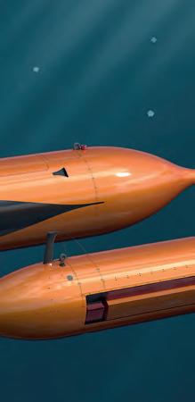
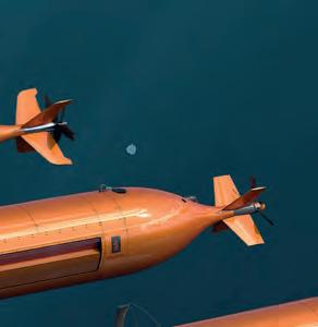


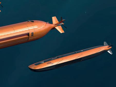
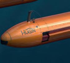


Discover the HUGIN family kongsberg.com/AUV resolution survey navigation solution with the best Powerful in-mission planning within a compact, lightweight design
The most successful AUV ever made
HUGIN
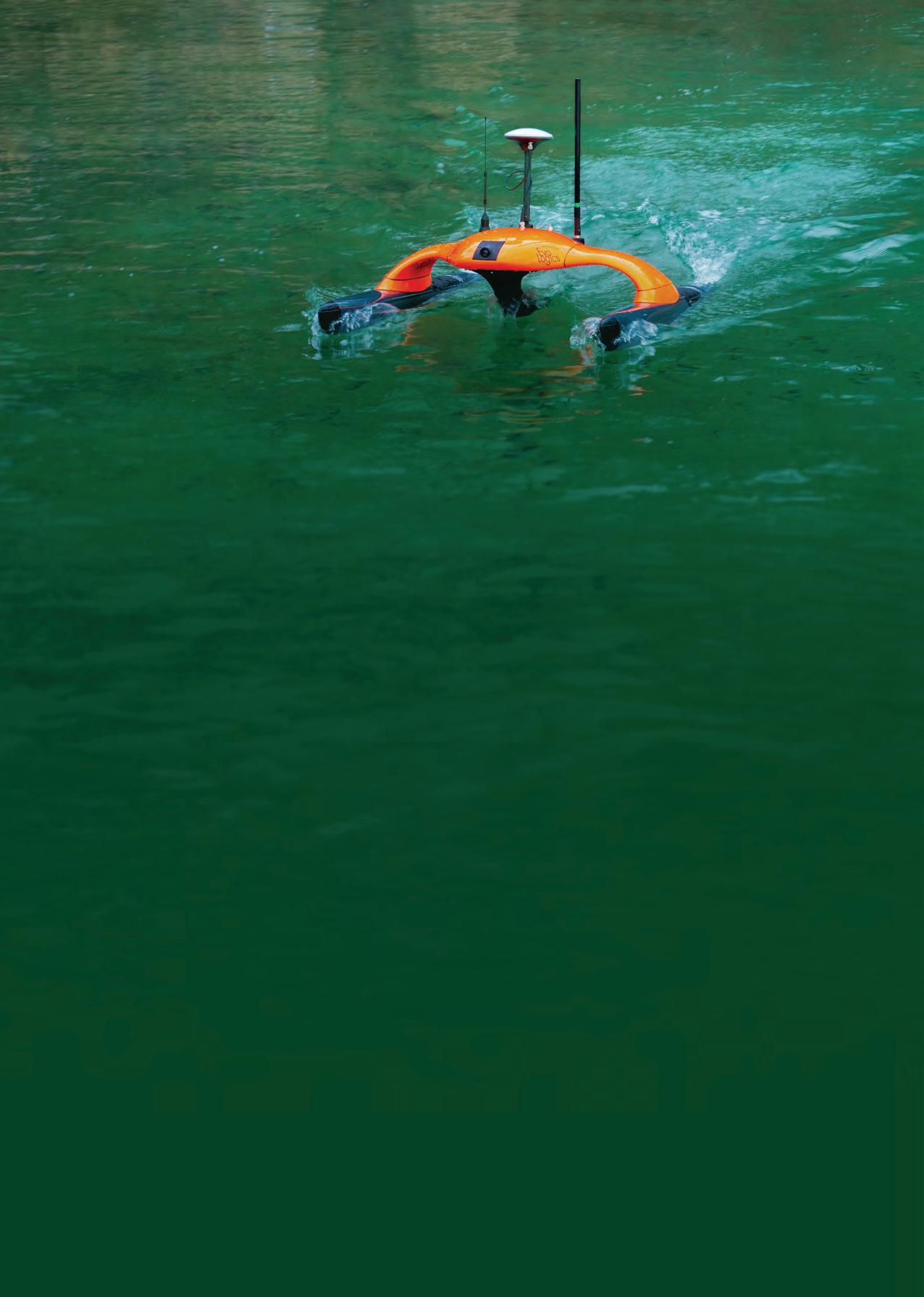
sales@evologics.de EvoLogics.de SONOBOT 5 UNCREWED SURFACE VEHICLE • Accurate georeferenced bathymetry and cartography missions, search and survey in hard-to-reach areas • Autonomous and remotely-controlled operation • Data logging and real-time acquisition over redundant mesh network • Exchangeable battery packs for 9+ hours of operation • System software for planning, execution and data evaluation • High-precision measurements and recordings, different GNSS and sonar options available • Rapid system deployment, excellent maneuverability and area coverage with powerful and efficient drives OBJECT
• objects of interest are detected and highlighted live during the mission • AI-based system as an extra module that runs directly onboard the vehicle and analyses raw data
RECOGNITION
