YOUR gim-international.com REPORT
By Frédérique Coumans, contributing editor, GIM International Report
Ordnance Survey Ireland Shows New Perspectives, Part 2
National Mapping as a Service National mapping organisations from all over the world are interested to see how Ordnance Survey Ireland (OSi) is planning for its future. Not only has OSi re-engineered its work processes and implemented a multiresolution data store to automate product and service delivery, but it has also developed a collaborative portal and is leading the way towards a National Mapping Agreement. OSi is now in the process of making ‘linked data’ available for all 50 million Irish real-world objects. Ordnance Survey Ireland (OSi) has a clear technical strategy for offering national mapping as a service. In its own words, OSi wants to offer its users the streaming of “multi-resolution, spatial products and services in industry data formats from a single source of highresolution topographic truth”. The ‘National Mapping-as-a-Service’ strategy is one of the reasons why OSi migrated numerous legacy multi-scale databases into a single, scaleindependent database known as PRIME2. It also implemented orchestrated, rule-based production workflows to enforce the highest levels of data quality, while enabling significant resource efficiencies in the various stages of data management. The newly developed data model is the foundation for OSi’s MultiResolution Data Store (MRDS) where the data objects are brought up to date maintained once and are then automatically processed to produce a wide variety of information and products. This initiative makes it possible for OSi to be the first national mapping agency in the world that can automatically produce 1:1,000,000 cartographic products and services from its 1:1,000 topographic database. For more information about that, read Part 1 of this series on OSi in the December 2016 issue of GIM International.
spatial data through a data catalogue and a map viewer. MapGenie, a commercial web-mapping service, already existed, giving both public-sector and private-sector customers access to map data. However, the use of MapGenie requires OGC-compliant GIS software or web applications, whereas GeoHive data can be queried and visualised directly. On GeoHive, you can create maps specific to the task at hand by combining layers of location-based information from a range of public-sector bodies. Being fully responsive, the system reconfigures itself depending on the device used to open the application, e.g. either a PC or a smartphone. Colin Bray, OSi’s
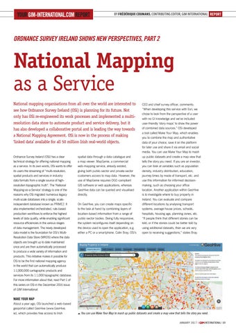
CEO and chief survey officer, comments: “When developing this service with Esri, we chose to look from the perspective of a user with no GI knowledge and we’ve included user-friendly ‘story maps’ to show the power of combined data sources.” OSi developed a tool called Make Your Map, which enables you to combine the map and authoritative data of your choice, save it on the platform for later use and share it via email and social media. You can use Make Your Map to mash up public datasets and create a map view that tells the story you need. If you are an investor, you can look at variables such as population density, industry distribution, education, journey times by mode of transport, etc. and use this information for informed decisionmaking, such as choosing your office location. Another application within GeoHive is to investigate where to buy property in Ireland. You can evaluate and compare different locations by analysing transport systems, average house prices, schools, hospitals, housing age, planning zones, etc. “If people think that different stories can be told, or if the stories could be better told by using additional datasets, then we are very open to receiving suggestions,” states Bray.
Make your Map About a year ago, OSi launched a web-based geoportal called GeoHive (www.GeoHive. ie), which provides free access to Irish
You can use Make Your Map to mash up public datasets and create a map view that tells the story you need. january 2 0 1 7 |
31-32-33_reportireland.indd 31
international | 31
06-01-17 11:38