DRY STONE WALL SURVEY – ASBY PARISH Summary Report


The Westmorland Dales Landscape Partnership Scheme aims to unlock and reveal the hidden heritage of the Westmorland Dales, which lies to the north of the Howgill Fells in Cumbria within the Yorkshire Dales National Park. This four year scheme is primarily funded by the National Lottery Heritage Fund, and involves 22 different projects, that explore the area’s natural and cultural heritage.
One of these projects focusses on Dry Stone
Walls One of the aims of this project was to carry out a community based survey in Asby parish. Dry stone walls represent one of the key landscape characteristics of the Westmorland Dales. They are dominant throughout the Yorkshire Dales landscape and are its largest man made feature. Dry stone walls are integral and represent how the land has been used and divided over many centuries.
There have been a number of landscape studies carried out elsewhere in the North of England. However, in many cases walls have been overlooked.
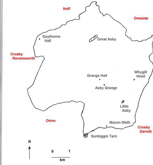
Asby parish was chosen for several reasons accessibility, a range of wall types and chronologies, and the availability of archival documentary and cartographic sources. However, certain areas of the parish were not included, i.e. if there was a lack of public access or dominated by hedges.
The objective was not to try and cover all walls, or to survey the entire length of chosen walls.
Rather, the survey was designed to investigate a meaningful sample of walls. The volunteer survey was led by Dr David Johnson. The volunteers were trained to analyse and interpret walls, as well as setting them in a chronological context.
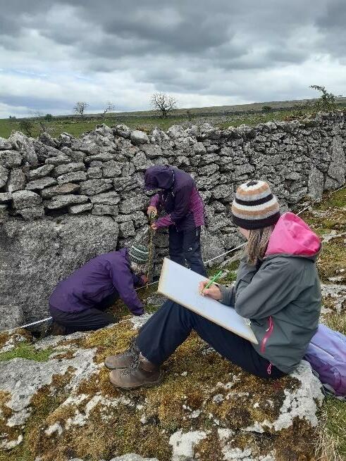
A total of 37 discrete walls were surveyed and recorded using a variety of desk based and archaeological techniques.
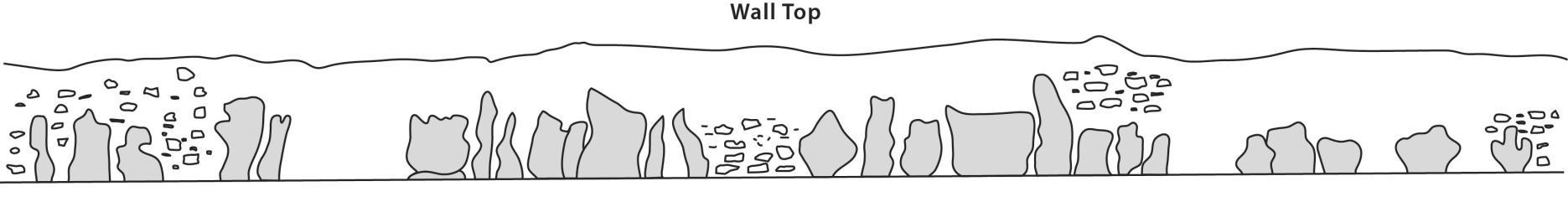
A range of survey techniques were applied though not all were used for every wall surveyed. To start, the volunteer team would walk each length of selected wall, identifying wall characteristics. This enabled a survey proforma sheet to be completed, and on the rear of each form a list of age characteristics was compiled. For many of the walls a cross profile was measured using a specially designed frame and plotted on a proforma graph. In one case, a long profile was drawn.
The results of this survey will be used to enhance the Yorkshire Dales National Park Authority’s Historic Environment Record. The results will contribute to a greater understanding of this heritage feature and is a useful survey example that could be replicated in other areas.
Byland Abbey, on the edge of the North York Moors, possessed three main granges (or estates) in Westmorland one of which was Asby. Under Byland’s control land in Asby would have been enclosed, most likely by cast banks or low stone walls. Documentary evidence suggests that no secular families of substance owned land in any of the Asby townships at this time In later centuries, the Lowther family held Asby Grange, and along with other lords of the manors and landowners, piecemeal enclosure took place. During the 16th to the 18th century much land was taken in from common land (or the ‘waste’), with intake walls being built on the lower slopes of upland valleys. Thirty nine percent of the total area of the parish was subjected to formal enclosure, through four discrete parliamentary enclosure awards spanning the years 1849 74.
The vast majority of Asby parish is underlain by Carboniferous Limestone strata. There are also two Carboniferous Sandstone types that occur within in the parish, mainly outcropping as narrow strips. Unlike much of the Westmorland Dales limestone plateau, superficial deposits of glacial till (boulder clay) are limited in their distribution and this in large part explains why Asby has relatively little farmland classified as acidic and of poor quality. In addition, large numbers of Shap Granite erratics were transported by ice flows and dumped across much of Asby as well as neighbouring parishes.
The geology of an area has a direct impact on wall characteristics. Earlier walls are predominantly constructed from field clearance stone, which was derived from glacial deposits. Whereas later walls using quarried stone reflect the specific local geology.
There is perhaps a whole debate about what is a wall. It is understood to be a solid boundary made of stone. However, in the past they were known as fences (or stone fences). And in some regions they are commonly known as dykes. Walls take many forms and there are distinct regional styles. In some historical landscapes including parts of Asby cast (or casten) banks are a common feature, taking the form of an earthen bank formed by casting (or throwing) up earth to form the linear bank and quite commonly with a stone revetment along one face, and sometimes a ditch running alongside. There are also other earlier field boundaries, including both bank and ditch networks, and hedges.
The survey produced a detailed report which is available separately. This is a simple overview of the results. No landscape feature should be examined in isolation as none exists or functions in isolation it is important to view landscape elements in their wider context. The approach of this project was to combine both field survey with documentary research.
The village has two lines of tofts (house plot) and crofts (pieces of land) facing each other across Asby Beck. As with many linear villages, a back lane was situated at the back of the crofts, separated by a stockproof wall or hedge. Extending beyond the Back Lane are long narrow closes defining a reverse S shape. Over time strips were amalgamated and exchanged. These strips would have originally formed part of open ploughland that was divided (not by any set physical boundary) into individual strips worked by the various tenants using an ox team. Over time, these ploughlands were expanded outwards, away from the Back Lane, as population and demand for food grew, particularly in the late 15th and through the 16th century. Beyond these strips were the open fields. Much of these were also under cultivation, proven today by the ridge and furrow arrangement seen in so many of the present closes.
In all, 37 wall lengths were included in the survey with the selection designed to incorporate walls of different periods, notably those from within the four enclosure award areas, others known to be relict walls, and others most likely to have originated in the late monastic or early post medieval eras.
Five broad wall types, based on chronology, were recognised in the survey (see table below).
Wall types Lengths Typology
Type 1 1800m Pre-conquest/early monastic (usually relict walls or cast bank or walls dominated by orthostats and recumbent blocks)
Type 2 7000m Late medieval/early post monastic (pre 1700, and in some cases pre-1600)
Type 3 35,000m Parliamentary Enclosure (1849 1874)
Type 4 254m Post 1700, non Parliamentary Enclosure
Type 5 37m Hybrid
of walls
Type 1 are classified as having originated in the wider medieval era, with some likely pre dating the Norman Conquest and others falling within or shortly after the monastic high medieval period. The walls in this survey are either relict walls or cast banks or walls dominated by orthostats and recumbent blocks. Within this type is wall no. 8, which consists of one section 48m in length with 29 orthostats in a line. The wall is built of limestone ripped off nearby limestone pavement. It is beyond doubt part of the external
boundary of Byland Abbey’s monastic grange in Asby. However, it was clearly built in two phases the lower part of the wall consists of a series of large to very large vertically set orthostats as well as large recumbent blocks, which might relate to a possible Anglo-Saxon period farmstead.
Type 2 walls are those from either the late monastic period or the early post monastic period, put up before 1700 (or in some cases before 1600). They can be characterised as:
1. generally higher than later walls, up to 1.6 2m below the topstones
2. wider than later walls, with basal widths up to 800mm+ and width below the topstones 600mm+
3. generally composed of sub rounded field clearance stone (from glacial deposits or watercourses) or slabs ripped off limestone pavement rather than of angular quarried stone. Some medieval walls have a ‘blocky’ nature
4. large recumbent basal slabs or blocks are common
5. large vertically set orthostats are common, either single or paired
6. a basal plinth may be visible
7. lack coursing (the stones were randomly placed in the wall)
8. rarely graded (stone size does not decrease from base to top, instead large stones can be found at any level in the wall)
9. topstones tend to be laid flat or at a very low angle
10. regular through courses are absent there may be occasional throughs
11. filling stones between the two wall faces are often largely absent or of a large size
12. looked at in long profile, tall early walls are generally straight sided rather than battered (basal and top widths are not very different)
13. seen in plan view, early walls tend to be sinuous rather than rectilinear
14. if corners are present, they tend to be rounded rather than squared with quoins
15. if early walls have original step stiles or gate stoops they tend to be large, rough and not peckdressed or machine sawn
It is important to note that not every variable needs to be met to decide if a wall is ‘early’, but the more variables that do apply the greater the level of confidence in ascribing a wall to this type or that. It is also important to bear in mind that there are exceptions to every rule. It follows that post 1700 walls have the opposite characteristics to those listed above.
It has been suggested that Type 3 walls, Parliamentary Enclosure walls, were put up by itinerant gangs. There was a standard Cumberland and Westmorland enclosue wall height of 4 feet 6 inches (1.37m). Most of these walls closely conform to this. The walls are built from locally quarried stone, with topstones laid near vertically, and well coursed and graded in stone size with continuous through courses. These walls were found to vary in quality.
Type 4 includes walls that have the characteristics of post 1700 building, but were not part of any formal enclosure agreement. And in this context, Hybrid walls show characteristics of old and new walls; in other words they most likely have very early basal stonework with clearly much later walling above. At some point in the past they were either comprehensively rebuilt or increased in height as stock management needs dictated.
Items of wall furniture, meaning small features built into dry stone walls for a specific purpose, can be an aid to interpreting particular lengths of wall and ascribing a tentative chronology. These features can include straight joints, gate stoops, gateways, sheep creeps, rabbit smoots, cattle creeps, water smoots, and stiles (step and squeeze). With regards to sheep creeps, it has been suggested that the ratio between width and height is an age indicator. Fourteen sheep creeps were recorded, all of which were now blocked.
This survey is among the most comprehensive archaeological dry stone wall survey undertaken anywhere in the country.
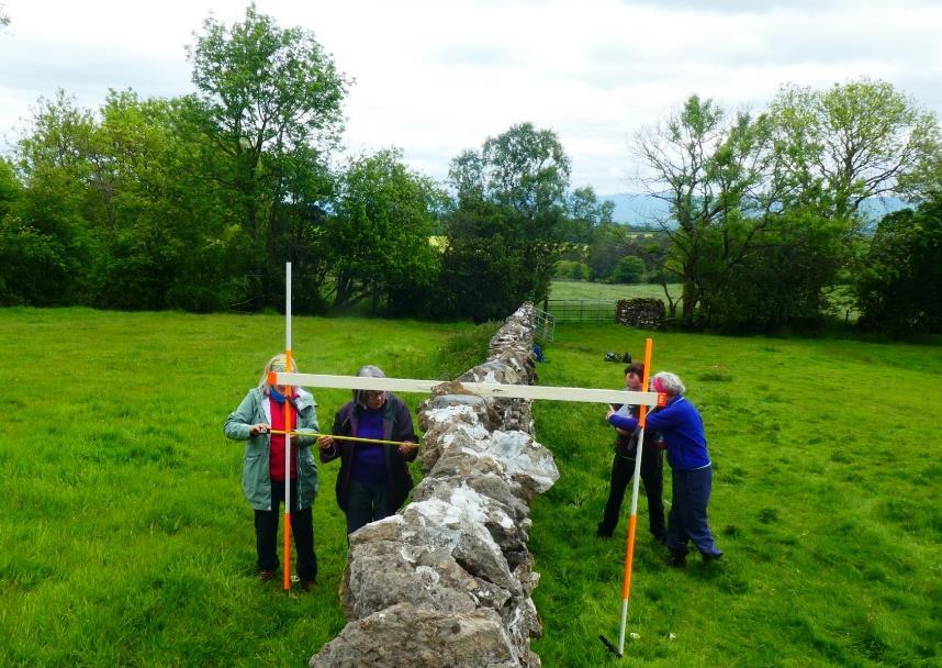
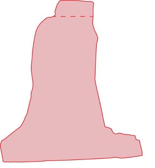
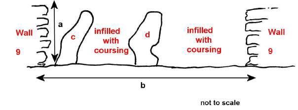
Figure 3 An example of a cross profie, in this case of a type 2 wall. Supplied by David Johnson
The Westmorland Dales Landscape Partnership team would like to thank all the volunteers for taking part in this project, both surveying and researching the walls in Asby. We are grateful for the experience that Dr David Johnson provided to the volunteers, as well as the project as a whole. Thanks must also be extended to all the landowners who granted us permission to survey on their land.
The project was funded by the National Lottery Heritage Fund
Please note that this summary report has been created using the report created by Dr Johnson: