

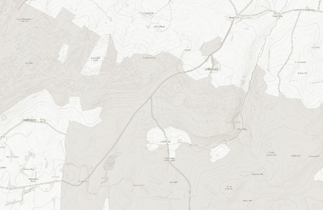
to Little Asby Common and Sunbiggin Tarn


Welcome to Little Asby Common
Purchased in 2003, Little Asby Common is part of a high, tilted plateau of upland limestone common land that defines the Westmorland Dales landscape in Eastern Cumbria. Following a successful campaign by Friends of the Lake District in 2016, it was included in a major extension to the Yorkshire Dales National Park. Our aim as owners is to enhance the Common, its landscape and habitats for people, nature and climate, trial new things, share our management practices with others, and use our experience to inform our campaigning on land-use policy.
Look out for: bird life at Sunbiggin Tarn, the cairn at the highest point and 360 degree views, restored bields and cast iron signpost, tree fold and the Dowly Tree.
Getting Here
Little Asby Common is situated about five miles east of Orton. It can be reached via the road from Raisbeck to Little Asby, or the road from Newbiggin-on-Lune. The grid reference of the junction of these two roads is NY 675 078 (OL19 Explorer map, Howgill Fells). There are no direct bus services across the Common, but buses from Appleby and Kirkby Stephen may pass nearby.
The Common is dedicated as Open Access Land so it can be explored freely on foot at any time. The Coast to Coast cyclepath, footpath and Lakes to Dales cycleroute also cross the common. To aid your visit, Ordnance Survey Explorer OL19 or Landranger 91 are recommended. Look out for our NFC/QR code signs if you want more information via your phone.
Explore and Discover
Walk Length: 4 miles approx.
Ascent: 173m Time Required: 2 hours approx.
Postcode: CA10 3SQ | Grid Reference: NY 67379 07668
Please follow the Countryside Code and keep dogs on their leads throughout the bird nesting season.
� Parts of the common can be disorientating, so please take a map. Please be mindful that walking on limestone pavement – including partially concealed clints and grykes – can be hazardous, especially when wet.

1 Start the walk at the beautiful Sunbiggin Tarn. There is space for parking by the cattle grid. Sunbiggin Tarn is a honeypot for birdwatchers. It is a ‘marl’ lake and supports rare plants and aquatic life.
2 Walk up the road from the tarn in a north-easterly direction, passing the historic finger post (restored by Friends of the Lake District) on your right at the T junction, until you reach the new tree fold on the left. The tree fold was built to protect new saplings as part of the Long View project in 2015. Look for the old ‘Dowly Tree’ stump slightly further on.
3 From the tree fold, cross the road and climb up the limestone pavement to the south towards the cairn at the peak of the common. From here the view is spectacular. You can see the stunning Howgills to the South, the Eastern Lake District fells to the West and the North Pennines to the east.
Legend
Suggested Walk Route
NFC & QR Locations
Public Rights of Way
Little Asby Common Boundary
Mazonwath Boundary Road
Open Access Land
4
From here, walk in a south-easterly direction towards the ridge where you can look out over Potts Valley and enjoy outstanding views in all directions. As you walk across the common you may notice the remnants of buildings or structures, some of which date back to prehistory. This area of the common contains traces of ancient field systems, evidence of farming from centuries ago.
5 Turn back towards the cairn and walk back towards the road. Once you reach the road, walk back down towards the Dowly Tree. Once you reach the Dowly Tree, climb up the track which leads up the common behind the tree fold and you will reach the Little Asby Hawthorn tree which was documented in the Long View project. This windswept tree has likely stood watch over the common for around a century, holding on between the limestone pavement.
Mazonwath
SUNBIGGIN TARN
MITCHELL’S STONE
SUNBIGGIN
6 From the hawthorn tree, walk west across the common towards the boundary wall. Once you reach the wall follow it down towards the road. Along the wall you will come across Mitchell’s Stone, another local landmark thought to be a boundary marker. It’s an example of a Shap granite erratic, deposited here during the last ice age.

7 From here, follow the wall back down towards Sunbiggin Tarn and the end of this walk route. This section of the walk is a good place for spotting a range of limestone grassland flowering species particularly in the early summer, including orchids and common rock rose.
Mazonwath
©
Rob Fraser
Our Top Achievements
Since purchasing Little Asby Common in 2003, Friends of the Lake District has:
• Worked with the commoners to reduce the impact of sheep grazing, including the reintroduction of cattle.
• Restored precious habitats such as heather moorland and limestone heathland.
• Surveyed nearly 200 archaeological sites, increasing our understanding of the Common’s archaeology.
• Successfully campaigned to see the area included in the Yorkshire Dales National Park.
• Overseen the Common becoming ‘open access land’ for those on foot to enjoy in perpetuity.
• Enabled research at Sunbiggin Tarn to establish why its water quality is changing, and taken core samples that show there has been human activity here for 10,000 years.
• Increased our understanding of how to manage a common and the issues facing common land.
• Managed the land in partnership with active commoners for both nature conservation and cultural heritage.
• Brought many different groups of people to experience the Common, raising awareness of the importance and issues of common land.
• Built up a team of volunteers to help us manage the Common, e.g. in dry stone walling and archaeological survey.

Common Land
Cumbria contains one third of the common land in England, much of it falling in upland areas of the Westmorland Dales. Common land is privately owned, but others have the right to graze livestock on it. Those entitled to such rights are called ‘commoners’. For centuries, commoners have grazed their animals on the upland fells, within close-knit communities. Access to common grazing was, until recently, vital to upland farms. Commons like Little Asby Common are still a working landscape; the product of generations of grazing herds of cattle and flocks of sheep, land clearances, industry and mutual interest.


Since the Countryside and Rights of Way Act 2000, common land has also been publicly accessible for recreational use and enjoyment.
Friends of the Lake District has a long history of working with common land throughout Cumbria. We are an active landowner working with the commoners to enhance the common. We manage for nature and culture, learning more about the rich cultural heritage of the area, which was until recently largely unknown, and have changed the grazing on the land to allow more habitat restoration. We also want the public to be able to enjoy this special area.


Geology
Little Asby Common lies on limestone laid down in the Carboniferous period when the area was covered by a shallow tropical sea. The Common is part of a wider dramatic limestone plateau that characterises the surrounding Westmorland Dales landscape. Classic features are limestone pavements, divided into blocks or ‘clints’ and fissures or ‘grykes’. Look out for fossils in dry stone walls and former quarry sites.

Other geological features include the dramatic Potts Valley. You might also notice occasional large boulders of granite, ‘erratics’, that were deposited across the area in the last ice age. Sunbiggin Tarn is a ‘marl’ lake, where glacial till (boulder clay) was deposited on the limestone, enabling the lake to form.
Want to learn more about our land and the species you can find there? Look out for our other guides! www.friendsofthelakedistrict.org.uk/property-guides
A Mosaic of Habitats
Little Asby Common is part of a European Special Area of Conservation (SAC) for its natural heritage, and is a Site of Special Scientific Interest (SSSI) for the range of habitats it supports. There are species that favour limestone pavement, like the ferns that grow in the sheltered niches between the limestone clints. Off the pavement, well-drained limestone grassland areas are potentially flower rich, e.g. with wild thyme and rock rose. Springs draining off the limestone carry lime-rich nutrients which allow plants such as Birds Eye Primrose, Butterwort, Valerian and Wild Angelica to thrive here.
Areas of heather moorland and peat are interspersed across the limestone, which support blanket bog and sphagnum moss, cotton grass, heather, crowberry, and bilberry.
Sunbiggin Tarn is fed by springs saturated with dissolved lime, making the tarn home to some rare aquatic species and invertebrates including snails and algae. Sunbiggin Tarn is also of importance to numerous bird species including waterfowl, such as wigeon, and wading birds, such as snipe. It is a resting place for many species on migration.
Little Asby Common is also home to breeding waders, such as lapwing and curlew, now internationally in decline. Sheep grazing helps maintain the habitats they prefer.


© Rob Fraser
Archaeology
The landscape contains evidence of human activity since prehistory, including funerary cairns and clearance cairns (piles of stones cleared to provide land for farming). The whole area was once wooded, but cleared from the Mesolithic period onwards for hunting, pasture land and settlement. The remains of three prehistoric settlements have been identified here, and various farmsteads comprised of ‘round house’ and stock enclosures. A Bronze Age ‘co-axial’ field-system extends across part of the common. This type of field-system, usually found in South-West England, is rare in the North West. There is evidence of prehistoric arable farming on specially built terraces on parts of the common.


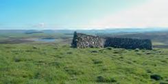
The common contains the remains of ‘shielings’ – small longhouse structures with associated stock enclosures, used by people pasturing livestock from the Iron Age to medieval period. There are remnants of many other post-medieval stock management features e.g. enclosures, bields, sheepfolds, and many small quarries.
People and the Landscape
Carboniferous period – Limestone formed.
Mesolithic and Neolithic periods – A landscape covered by abundant mixed woodland, gradually cleared by humans for hunting and later for settlement and farming. Bronze Age – Evidence of arable farming becoming more organised and extensive. Evidence of trading.

Iron Age – Largely open environment of sedge moorland. Possible low-scale arable cultivation continued, but mainly grazing of the land by livestock, along with exploitation of natural resources by the local population. Medieval – Shieling structures for summer pasturing of the uplands. Common exploited for its natural resources including turf and stone.
19 th century – Parliamentary enclosures elsewhere in the parish but common grazing on largely unenclosed commons continues here. Some shooting for grouse continues into the 20th century.
20 th century – Common designated as an SSSI and SAC. 2003 – Friends of the Lake District purchases Little Asby Common with help of a grant from English Nature.
2016 – Yorkshire Dales National Park extension.
Today – There are nine active graziers who graze the land with sheep and cows, supported via an agri-environment scheme to manage the land in a more environmentally friendly way.
© James Innerdale
About Friends of the Lake District
Established in 1934, Friends of the Lake District is a membership-based charity committed to looking after the landscapes of the Lake District and Cumbria.

Scan here to become a member today. Join us and over 6,000 people who are passionate about this magnificent place.
Friends of the Lake District’s land is open to the public and for all to enjoy! We own land from Threlkeld in the north, to Kendal in the south, and from Eskdale in the West, to Asby near Orton in the east. This is a mix of farmland, common land and woodlands.
Keswick
Orton
For more information on our land, how to join us and help to maintain these beautiful Cumbrian landscapes or volunteering opportunities please get in touch, or sign up to our email newsletter.
Friends of the Lake District, Murley Moss, Oxenholme Road, Kendal, LA9 7SS
Tel: 01539 720788 | Email: info@fld.org.uk
Website: www.friendsofthelakedistrict.org.uk
� � #friendsofthelakedistrict
Registered Charity Number: 1100759