I D E N T I F Y I N G
T R A N S P O R T A T I O N
P R O J E C T S I M P A C T I N G
F R E E D O M C O L O N I E S


T H E T E X A S F R E E D O M C O L O N I E S
P R O J E C T A T L A S A N D S T U D Y 2 0 2 5


I D E N T I F Y I N G
T R A N S P O R T A T I O N
P R O J E C T S I M P A C T I N G
F R E E D O M C O L O N I E S


T H E T E X A S F R E E D O M C O L O N I E S
P R O J E C T A T L A S A N D S T U D Y 2 0 2 5

ThisbookletprovidesguidanceonusingTheTexasFreedom ColoniesAtlas.�� InformationintheAtlasisorganizedby layers,andeachlayerdisplaysadifferentkindofdata.This bookletspecificallycoverslayersthatwillhelpyouidentify transportationprojectsthatmayposeathreattoFreedom Coloniesandtoprovideinputduringtheprojectplanning phase.
Withinthisbooklet,youwillfind:
Tips for interpreting Texas Department of Transportation (TxDOT) layers
Instructions for accessing the TxDOT layers
Tools and regulations that descendants, community members and stakeholders can access to voice their concerns
The definitions of words and terms in bold blue font throughout this booklet can be found in the glossary on the following page.
�� Resource Anchor
Whenever you see this icon, it means that a QR code to quickly access the resource is listed at the end of the guide in the “Scan and Explore” section.
district: a division of a town, city, or state made for political administration purposes. In this guidebook, the districts referred to are TxDOT administrative districts. �� TxDOT divides Texas into 25 districts.
feasibility study: a study done before a project begins in order to decide if the project is possible or reasonable layer: an element of an online map, like the Atlas, containing specific information like district boundaries or demographic information. Layers can be turned on and off, and you can turn on more than one layer at once to compare the information in each.
stakeholders: people who have an interest or involvement in something’s success. They may also be known as “consulting parties.”
We are providing these layers to enable descendants who may not be full-time residents or landowners to remain aware of what is happening in their communities. Knowing about projects years in advance means that descendants aren't on the defense and then have an opportunity to ask questions and proactively co-plan with public agencies.

Dr. Andrea Roberts , PhD

Interstate 45 serves as a backdrop to the historic Fourth Ward Freedman's Town in Houston, Texas, a freedom colony.
The National Historic Preservation Act was passed in 1966 to help protect historic sites and properties from being destroyed by infrastructure projects. Part of the Act, Section 106, states that any project receiving federal funding must evaluate its potential impact on historically and culturally important places, and reduce any harm caused to these places. For more about Section 106, see the resources at the end of this guide on page 13. ��
It also states that stakeholders (also known as “consulting parties” in the language of Section 106) must be given the chance to comment on the potential impacts of a project. This guide provides you with resources to find out 1) how TxDOT projects may affect your community, and 2) provide TxDOT with your comments.

Section 4(f) of the U.S Department of Transportation (USDOT) Act of 1966 prohibits the FHWA and other USDOT agencies from using land from publicly owned parks, recreation areas (including recreational trails), wildlife and water fowl refuges, or public and private historic properties, unless there is no alternative to that use and the action includes all possible planning to minimize harm to the property resulting from such use. TxDOT must comply with Section 4(f) because it represents the FHWA in Texas.

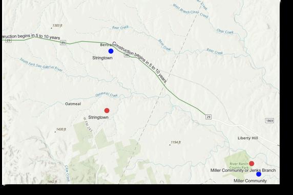
Left: A transportation project scheduled to begin in 5-10 years may affect Stringtown (northwest of Austin)
TxDOT makes data about their upcoming projects available to the public. Our team has taken this data and transformed it into layers for the Atlas.
The Texas Freedom Colonies Project Atlas contains three layers that will show you upcoming TxDOT projects: projects undergoing a feasibility study projects 5-10 years away projects at least 10 years away
1.Clickon"TheAtlas:Map&Database”in theright-handmenutoviewtheAtlas. ��
2.Agreetothetermsandconditionsof usingtheAtlas
3. Select the icon in the upper righthand corner in the green bar that looks like a stack of paper. This is the list of the Atlas’ layers.
4. Click the checkboxes next to “TxDOT Projects - 5 to 10 Years Away,” “TxDOT Projects - 10+ Years Away,” and/or “TxDOT Projects - Feasibility Studies” to turn on the layer(s).
5. Click on the colored line(s) on the map to learn more about a project.


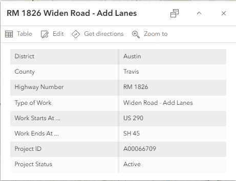
When you click on a transportation project in the Atlas, a pop-up box with the following details will appear:
the project district the project county the type of work (e.g. widening, resurfacing) the highway number where the project starts where the project ends the project ID the project status (e.g. active, closed)
You can use these details to learn more about a project on TxDOT’s website, find out when and how to attend meetings, and submit comments to TxDOT.

Enter your email on TxDOT’s public meetings page ��in order to be notified about upcoming opportunities to provide input on projects. This page also has a schedule of past and upcoming meetings.
There are multiple ways to contact TxDOT to provide comments. You can:
Use the general question contact form ��
Call or email a district office ��
Contact a district’s historical studies planner (see following page)

The map above shows TxDOT’s historical studies contacts and their phone numbers by district. They will be aware of the Section 106 process and can guide you on the best way to offer further input to TxDOT.
Map appears courtesy of TxDOT Environment Affairs Division Cultural Resources Section
Use the QR codes and links below to quickly access the resources mentioned throughout this guide.
The Texas Freedom Colonies Atlas https://www.thetexasfreedomcoloniesproject.com/atlas
Referenced p. 1 1
TxDOT Administrative Districts https://wwwtxdotgov/about/districtshtml
Referenced p. 2
A Citizen’s Guide to Section 106 Review
https://www.achp.gov/sites/default/files/documents/201701/CitizenGuide.pdf
Referenced p. 5
Connecting People and the Past
https://ftptxdotgov/pub/txdot-info/env/beyond-theroad/connecting-people.pdf
Referenced p. 5
A Guide to Getting Involved in TxDOT’s Historic Preservation Program
https://ftp.txdot.gov/pub/txdot-info/env/beyond-theroad/historic-preservation-processpdf
Referenced p. 5
Use the QR codes and links below to quickly access the resources mentioned throughout this guide.
TxDOT’s Section 106 Training Series https://wwwtxdotgov/business/resources/training/sec-106training.html
Referenced p. 5
TxDOT’s Historic Preservation Page
https://www.txdot.gov/about/campaignsoutreach/archeology-history/getting-involved-historicpreservationhtml
Referenced p. 5
TxDOT Hearings, Meetings, and Notices Schedule https://www.txdot.gov/projects/hearings-meetings.html
Referenced p. 11
TxDOT General Question Contact Form https://www.txdot.gov/about/contact-us/ask-a-generalquestionhtml
Referenced p. 11
