
contract of sale the pride of the south-east. Stage 8 – Lot number:
by a scheme approved under Professional Standards Legislation. Ref KAE 307372 00369

Russell 940 5146, 3001 494 info@rk.com.au

Honour Village, Stage 8
DX
Melbourne VIC
Lot on PS900399W Berwick Waters, Clyde North
Melbourne T +61 3 9609 1555 F +61 3 9609 1600
Liability limited

CONTRACT OF SALE OF REAL ESTATE
Kennedy Pty Ltd ACN 126 792 470 ABN 14
russellkennedy.com.au
129 185 Level 12, 469 La Trobe Street,Melbourne VIC 3000 POBox

You are entitled to a refund of all the money you paid EXCEPT for $100 or 0.2% of the purchase price (whichever is more) if you end the contract in this way
Tod O’Dwyer / Craig Muse/ Sarah Bloom / Anthony Boyd / Alex Newell / Jill Lim / Theo Della Bosca / Penelope Dabner under power of attorney dated 26 August 2021
Print name of person signing State nature of authority (if applicable) (e.g. "Director, Attorney under power of attorney dated the .") This offer will lapse unless accepted within [ ] clear business days (3 clear business days if none specified)
...................................................................................................
on
IMPORTANT NOTICE TO PURCHASERS
EXCEPTIONS The 3 day cooling off period does not apply if you bought the property at or within 3 clear business days before or after a publicly advertised auction; or the property is used primarily for industrial or commercial purposes; or the property is more than 20 hectares in size and is used primarily for farming; or you and the vendor have previously signed a contract for the sale of the same land in substantially the same terms; or you are an estate agent or a corporate body.
SIGNED BY THE DEVELOPER
The authority of a person signing: under power of attorney; or as director of a corporation; or as an agent authorised in writing by one of the parties must be noted beneath the signature.
on
.................................................................................................
Property Address: Lot on PS900399W, Berwick Waters, Clyde North
You must either give the vendor or the vendor's agent written notice that you are ending the contract or leave the notice at the address of the vendor or the vendor's agent to end this contract within this time in accordance with this cooling-off provision.
The DAY OF SALE is the date by which all parties have signed this contract.
SIGNED BY THE PURCHASER
State nature of authority (if applicable)
Any person whose signature is secured by an estate agent acknowledges being given by the agent at the time of signing a copy of the terms of this contract.
Signed for and on behalf of Frontlink Pty Ltd by , an authorised substitute attorney of Frontlink Pty Ltd’s attorney Australand Residential No. 156 Pty Ltd (formerly known as Australand Industrial No. 156 Pty Ltd and appointed pursuant to power of attorney dated 14 September 2007) pursuant to power of attorney dated 26 August 2021
Print name of person signing State nature of authority (if applicable)
NMO 13795453v4 NMO
The
Print name of person signing Tod O’Dwyer / Craig Muse/ Sarah Bloom / Anthony Boyd / Alex Newell / Jill Lim / Theo Della Bosca / Penelope Dabner under power of attorney dated 26 August 2021
Cooling off period (Section 31 Sale of Land Act 1962)
on
You may end this contract within 3 clear business days of the day that you sign the contract if none of the exceptions listed below applies to you.
CONTRACT OF SALE OF REAL ESTATE
SIGNING OF THIS CONTRACT WARNING: THIS IS A LEGALLY BINDING AGREEMENT. YOU SHOULD READ THIS CONTRACT BEFORE SIGNING IT.
Purchasers should ensure that prior to signing this contract, they have received: a copy of the section 32 statement required to be given by a vendor under section 32 of the Sale of Land Act 1962 in accordance with Division 2 of Part II of the Act; and a copy of the full terms of this contract.
The vendor agrees to sell and the purchaser agrees to buy the property, being the land and the goods, for the price and on the terms set out in this contract. terms of this contract are contained in the Particulars of sale; and Special conditions, if any; General conditions in that order of priority.
SIGNED BY THE VENDOR
PARTICULARS OF SALE
AddressName:: Telephone: Email:
VENDOR'S ESTATE AGENT
Name: Frontlink Pty Ltd ACN 074 034 496
Address: Level 3, 1C Homebush Bay Drive, Rhodes, NSW 2138 PURCHASER
NOTICE TO PURCHASERS OF PROPERTY “OFF-THE-PLAN”
If yes, is the purchaser carrying on the purchaser’s business or enterprise (being a creditable purpose) in buying the land? Yes No
A copy of any one of the following has been provided to the Vendor (tick as applicable): Australian driver's licence Birth certificate Australian citizenship certificate Passport* (*Foreign purchasers must provide copy)
Name: Oliver Hume Real Estate Group Pty Ltd
Is the purchaser registered for GST? Yes No
You may negotiate with the vendor about the amount of the deposit moneys payable under the contract of sale, up to 10 per cent of the purchase price.
Address: Level 2, 4 Riverside Quay, Southbank, Victoria 3006
NMO 13795453v4 NMO
Off-the-plan sales Section 9AA(1A) Sale of Land Act 1962
A substantial period of time may elapse between the day on which you sign the contract of sale and the day on which you become the registered proprietor of the lot.
Telephone: 9669 5999 Fax: 9669 5995 DX Email: VENDOR
Address: C/- Level 9, 484 St Kilda Road, Melbourne 3004
Name: Russell Kennedy Pty Ltd Ref: NBW
Address: Level 12, 469 La Trobe Street, Melbourne, 3000 Telephone 9609 1555 Fax: 9609 1600 DX 494 Email: nwlasiuk@rk.com.au DEVELOPER
If there is more than one party named as Purchaser, the parties will hold the Property in the following manner (tick as Jointapplicable):tenants
Name: Australand Residential No. 156 Pty Ltd ACN 107 356 543
The value of the lot may change between the day on which you sign the contract of sale of that lot and the day on which you become the registered proprietor.
Tenants in common in the following respective shares: % % %
IDENTIFICATION REQUIREMENTS
VENDOR'S LAWYER OR CONVEYANCER
TERMS CONTRACT
SETTLEMENTscheme
GOODS SOLD WITH THE LAND (List or attach schedule)
PROPERTY ADDRESS
GST (refer to Special Condition 18)
LEASE
If this is a sale of a ‘farming business’ or ‘going concern’ then add the words ‘farming business’ or ‘going concern’ in this box: not applicable
LAND
The price includes GST (if any) unless the words ‘plus GST’ appear in this box: inclusive of GST
being 10% of the price, of which $________ was paid on ________ (“Initial Deposit”), with the balance payable on the execution of this contract by the purchaser or within ________ from the date of this contract
Nil
4 NMO 13795453v4 NMO
At settlement the purchaser is entitled to vacant possession of the property unless the words ‘subject to lease’ appear in this box, in which case refer to general condition 1.1. not applicable
Balance $ payable at settlement
is due on ______________________________
Deposit $
If the margin scheme will be used to calculate GST then add the words ‘margin scheme’ in this box: margin
PURCHASER'S LAWYER OR CONVEYANCER
If ‘subject to lease’ then particulars of the lease are: not applicable
Telephone:Address: Fax: DX Email:
PAYMENTPrice $
Address: the land together with any improvements known as Lot on Plan of Subdivision PS900399W, Berwick Waters, Clyde North Project Stage:Honour Village Stage 8
Name: Ref:
The land is described in the attached copy title(s) and plan(s) as: Certificate of title volume folio or Lot on proposed plan of subdivision no PS900399W ("Plan") being part of the land in certificate of title volume 12396 folio 682 and includes all improvements and fixtures
unless the land is a lot on an unregistered plan of subdivision, in which case settlement is due on the later of: the above date; and 14 days after the vendor gives notice in writing to the purchaser of registration of the plan of subdivision.
LoanLenderbeing
If the contract is subject to ‘Special Conditions’ then particulars of the Special Conditions are attached. Settlement and lodgement will be conducted electronically in accordance with the Electronic Conveyancing National Law (Victoria) and Special Condition 58 applies, if “EC” is inserted in the box below.
If this contract is intended to be a terms contract within the meaning of the Sale of Land Act 1962 then add the words ‘terms contract’ in this box and refer to general condition 23 and add any further provisions by way of Special Conditions:
LOAN
Is the Purchaser a Foreign Interest?
This contract does not include any special conditions unless the words ‘Special Conditions’ appear in this box:
Special Conditions
FOREIGN INTEREST
If the Purchaser is a Foreign Interest, has the Purchaser obtained FIRB approval?
not applicable
EC
SPECIAL CONDITIONS
Approval Date / /
Yes No
not less than $ and no greater than $
Yes No
5 NMO 13795453v4 NMO
For the purposes of this contract, "Foreign Interest" means a foreign person as defined in the Foreign Acquisitions and Takeovers Act 1975 and includes a person deemed to be a foreign person pursuant to section 54(7) of the Act.
6 NMO 13795453v4 NMO
7 NMO 13795453v4 NMO
8 NMO 13795453v4 NMO
9 NMO 13795453v4 NMO
10 NMO 13795453v4 NMO
11 NMO 13795453v4 NMO
12 NMO 13795453v4 NMO
13 NMO 13795453v4 NMO
14 NMO 13795453v4 NMO SPECIAL CONDITIONS TABLE OF CONTENTS 1 DEFINITIONS..................................................................................................................17 2 INTERPRETATION 22 3 GENERAL CONDITIONS DELETED OR AMENDED .....................................................23 4 GUARANTEE..................................................................................................................24 5 NOMINATION .................................................................................................................24 6 ACKNOWLEDGMENTS BY PURCHASER.....................................................................25 7 DEPOSIT.........................................................................................................................26 8 DEPOSIT BY BANK GUARANTEE OR DEPOSIT BOND..............................................27 9 LOAN 28 10 DEFAULT........................................................................................................................28 11 CONDITION, RISK, IDENTITY AND USE OF PROPERTY.............................................29 12 FOREIGN INVESTMENT ................................................................................................32 13 FIRB APPROVAL ...........................................................................................................33 14 PURCHASER’S WARRANTIES CONCERNING FUNDS ...............................................35 15 SETTLEMENT AND TRANSFER....................................................................................35 16 CONFIDENTIALITY 36 17 PURCHASER’S WARRANTIES......................................................................................37 18 GST.................................................................................................................................38 19 GST WITHHOLDING LEGISLATION..............................................................................38 20 DUTY INDEMNITY 41 21 VENDOR WARRANTIES................................................................................................41 22 ADJUSTMENTS..............................................................................................................41 23 ADDITIONAL LAND TAX LIABILITY 42 24 NOTICES ........................................................................................................................43 25 FENCING ........................................................................................................................43 26 FILLED LAND.................................................................................................................44 27 UNREGISTERED PLAN 45 28 PERSONAL INFORMATION...........................................................................................47
NMO 13795453v4 NMO 15 29 PURCHASER AS TRUSTEE ..........................................................................................49 30 PLANNING CONTROLS.................................................................................................49 31 SECTION 173 AGREEMENTS........................................................................................50 32 GAIC 50 33 DESIGN AND SITING GUIDELINES...............................................................................51 34 AMENDMENTS TO RESTRICTIONS..............................................................................52 35 REPLACEMENT RESTRICTIVE COVENANT ................................................................53 36 BUILDING PERMIT.........................................................................................................53 37 MEDIUM DENSITY SITES/MULTI DWELLING LOTS ....................................................53 38 SIGNAGE........................................................................................................................54 39 ENTRY FEATURE 54 40 CONCEPT PLAN ............................................................................................................55 41 RECYCLED WATER.......................................................................................................55 42 VENDOR’S RIGHT TO MAINTAIN..................................................................................56 43 UTILITY SERVICES........................................................................................................56 44 ELECTRICAL SUBSTATIONS........................................................................................56 45 FIBRE OPTIC INSTALLATION.......................................................................................56 46 ACKNOWLEDGEMENT REGARDING STREET NAMES 56 47 BUSHFIRE PRONE AREAS ...........................................................................................57 48 INSPECTION...................................................................................................................57 49 TIME................................................................................................................................57 50 SALES MATERIAL 57 51 ACKNOWLEDGEMENT REGARDING SCHOOL SITE ..................................................58 52 OPEN SPACE.................................................................................................................58 53 DRAINAGE RESERVES 58 54 DEVELOPER’S OBLIGATIONS......................................................................................58 55 ACKNOWLEDGEMENT REGARDING FOOTPATHS.....................................................59 56 LANDSCAPING ..............................................................................................................60 57 NATURE STRIP 60 58 ELECTRONIC CONVEYANCING ...................................................................................60
NMO 13795453v4 NMO 16 59 FOREIGN RESIDENT CAPITAL GAINS WITHHOLDING TAX.......................................62 60 DISPUTES.......................................................................................................................62 61 ONLINE DUTIES FORM..................................................................................................63 62 NEIGHBOURHOOD ACTIVITY CENTRE 63 63 BELLS ROAD .................................................................................................................64 64 ENERGISATION OF ESTATE.........................................................................................64 65 PROSPERITY PROGRAM..............................................................................................64 66 ELECTRONIC EXECUTION OF CONTRACT.................................................................64 67 DISPLAY VILLAGE.........................................................................................................65 68 RETAINING WALL..........................................................................................................66 69 GENERAL 66
In this Contract and the Vendor’s Statement, capitalised terms have the meaning given to them in the Particulars of Sale, and, unless the context otherwise requires:
1.10.3 poisonous, noxious, offensive, harmful or potentially harmful to human beings, animals, birds or wildlife, plants or vegetation;
1.4 "Bank Guarantee" means an unconditional and irrevocable bank guarantee issued by a Bank with a current Standard and Poor rating of A minus or above and an office maintained in Australia, in a form and on terms which are acceptable to the Vendor (acting reasonably).
DEFINITIONS
1.6.3 the Purchaser requiring the Vendor to take or refrain from taking any action; and
1.9 "Concept Plan" means the concept plan attached to the Vendor’s Statement
1.10.5 not comply with any Law including any Environmental Law.
1.1 "ASIC" means the Australian Securities & Investments Commission.
1.10.4 degraded in any way; or
1.10 "Contaminant" includes all materials, pollutants, contaminants and substances that make or may make the Property:
SPECIAL CONDITIONS
1.10.1 polluted as defined in the Environment Protection Act 2017 (Vic);
1
1.3 "Bank" means an authorised deposit taking institution as defined in the Banking Act 1959 (Cth).
1.2 “ATO” means the Australian Taxation Office.
1.5 "Business Day" means a day other than a Saturday, Sunday or public holiday in Melbourne.
1.6 "Claim" includes:
1.6.2 any delay in Settlement or rescission or termination of this Contract or attempt to do so;
1.6.4 the Purchaser withholding any part of the Price.
1.7 "Clearance Certificate" means a certificate issued under section 14-220 of Schedule 1 to the TAA.
NMO 13795453v4 NMO
1.6.1 any claim, objection, requisition, notice, demand, action, proceeding, litigation, investigation or judgment, whether based in contract, tort, statute or otherwise;
1.8 “Commissioner” has the meaning given in the TAA.
1.10.2 poisonous or noxious;
"Due Date for Settlement" means the date provided for in the Particulars of Sale for payment of the Balance.
"Design and Siting Guidelines" means the design and siting guidelines in the form or substantially in the form of those attached to the Vendor’s Statement or as provided by the Vendor to the Purchaser from time to time
"Development Land" means all the land described in certificate of title volume 4024 folio 689 including any lot, reserve, road or otherwise created upon subdivision of that land.
1.24
"Finished Surface Levels Plan" means the layout plan attached to the Vendor's Statement.
1.20
"FIRB Application" means a notice of the Purchaser’s intention to purchase the Property made and delivered pursuant to the Takeovers Act in the prescribed form and in accordance with any current guidelines or policies regarding Australian foreign investment policy.
1.22
1.25
"FIRB Approval" means the decision made by or on behalf of the Treasurer under the Takeovers Act to the effect that the Commonwealth Government does not object to the transactions contemplated by this Contract, either unconditionally or subject to conditions.
"Corporations Act" means the Corporations Act 2001 (Cth).
1.19
"Environmental Law" means any Law relating to the environment or occupational, health and safety matters or regulating or imposing liability or standards of conduct concerning any substance or material.
1.27
1.21
18 NMO 13795453v4 NMO
“ECN Law” means the Electronic Conveyancing National Law (Victoria)
1.11
1.17
1.26
"Foreign Interest" means a foreign person as defined in the Takeovers Act and includes a person deemed to be a foreign person pursuant to section 54(7) of the Takeovers Act.
"Due Diligence Checklist" means the due diligence checklist defined in Section 33A of the Sale of Land Act 1962 (Vic).
1.14
1.18
1.23
"FIRB Approval Date" means the date which is 60 days after the Day of Sale.
1.13 "Council" means Casey City Council.
"Deposit Bond" means an unconditional and irrevocable deposit bond issued by a Bank with a current Standard and Poor rating of A minus or above and an office maintained in Australia, in a form and on terms which are acceptable to the Vendor (acting reasonably)
1.16
"Default Interest" means interest calculated at the rate of 2% above the rate for the time being fixed under section 2 of the Penalty Interest Rates Act 1983 (Vic).
1.15
"Contract" means this contract of sale of real estate, including the Particulars of Sale, General Conditions, Special Conditions, Schedules and annexures (if any) and attachments to this contract
"FIRB" means the Foreign Investment Review Board.
1.12
1.30
1.37
(a) is placed under administration;
1.36
1.38
1.28
"General Conditions" means the general conditions included in this Contract.
1.31 "Government Agency" means any:
1.31.1 government or government department or other body;
“GST Withholding Notice” means the notification required under section 14 255 of Schedule 1 to the TAA to be made on or before the making of the supply which states whether or not the Purchaser is required to make a payment on account of GST to the Commissioner and, if so, the amount of the payment.
1.39 "Guarantor" means the person(s) named in the Guarantee as guarantor.
“GST Withholding Amount” means the amount that the Purchaser is required to withhold on account of GST from the Price and pay to the Commissioner as notified by the Vendor in the GST Withholding Notice.
1.40.1 if the party is a natural person, the party:
1.31.2 governmental, semi governmental, municipal, administrative, statutory or judicial person, body or authority; and
1.29 "GAIC Law" means Part 9B and any other applicable parts of the Planning and Environment Act 1987 (Vic) and any regulations in relation to GAIC.
"GAIC" means the growth areas infrastructure contribution pursuant to the GAIC Law.
1.31.3 a person (whether autonomous or not) charged with administration of any applicable Law.
1.32 "GST" has the same meaning as defined in the GST Law and also includes penalties and interest
1.34 "GST Law" has the same meaning as defined in the GST Act.
1.35
"GST Settlement Notification Form” means the notification given by the Purchaser to the Commissioner that an amount of GST was withheld at Settlement and paid to the Commissioner.
"Guarantee" means the guarantee and indemnity in the form attached to this Contract.
1.40 "Insolvency Event" means:
(a) dies or ceases to be of full legal capacity or otherwise becomes incapable of managing the party's own affairs; or
(b) becomes insolvent under administration (as the terms is defined in the Corporations Act);
19 NMO 13795453v4 NMO
1.33 "GST Act" means the A New Tax System (Goods and Services Tax) Act 1999 (Cth).
1.40.2 if the party is a corporation, the party:
1.45 "Particulars of Sale" means the particulars of sale in this Contract.
or any analogous event under the laws of any applicable jurisdiction.
(d) enters into an arrangement, composition or compromise with, or assignment for the benefit of, any of that party’s creditors or any class of them;
(e) as a result of section 459F(1) of the Corporations Act, is taken to have failed to comply with a statutory demand; or
1.44
1.50
"Interest" means interest earned on the Deposit less any taxes, duties, fees, costs and charges.
1.42
"Loss" means any liability, charge, claim, loss, damage, expense or cost including any legal costs on a solicitor/client basis.
(b) is placed in liquidation or provisional liquidation;
(c) has a controller (as defined in the Corporations Act) or analogous person appointed to that party or any of that party’s property;
(f) lodges an application for that party’s voluntary deregistration with ASIC or is subject to any actions by ASIC to initiate the deregistration of that party,
1.41
20 NMO 13795453v4 NMO
1.48 "Plan" means Plan of Subdivision PS900399W a copy of which is annexed to the Vendor’s Statement.
1.49 "Planning Controls" means the planning scheme, overlays, planning permits and other planning controls imposed by any Law or any regulation of any Government Agency (including any municipal council) which apply to, from time to time, the use or development of the Land or the Development Land.
"Planning Permit" means planning permit PlnA00048/16 issued by the Council on 27 April 2017 or any other planning permit issued for the use and/or development of the Development Land, or any part of the Development Land of which the Land is a part, issued by the Council (as amended from time to time).
1.43
"Personal Information" means all personal information as defined in the Privacy Act relating to the Purchaser including all Personal Information set out in this Contract and otherwise collected by the Vendor whether before or after the Contract date.
1.47 “Privacy Statement” means the statement containing matters about the Vendor’s information handling practices as required by the Privacy Act set out in Annexure 1.
"Law" means any law, rule, Act, ordinance, regulation, by law, local law, order, statutory instrument, control, restriction, direction, notice or proclamation and includes the requirements of any municipal or statutory body or any permit, planning scheme or approval affecting the Land.
“Online Duties Form” means the digital form introduced and imposed by the SRO for the purpose of assessment of duty on transfers of land.
1.46
"Property" means the Land and any improvements on the Land.
"Responsible Authority" means the responsible authority under the Casey Planning Scheme in respect of the Land.
1.61
1.56
1.63.1 the provision of:
1.52
1.51.1 any consolidation, amendment, re enactment or replacement of any of them or the Privacy Act; and
"Section 173 Agreement" means an agreement under Section 173 of the Planning and Environment Act 1987 (Vic).
(a) vacant possession; or
"Related Body Corporate" means the same as "Related Body Corporate" means in the Corporations Act.
21 NMO 13795453v4 NMO
"Replacement Restrictive Covenant" means the restrictive covenant created or to be created pursuant to Special Condition 35
1.63
"Schedule" means a schedule to this Contract.
1.57
1.54
"Privacy Act" means the Privacy Act 1988 (Cth) and any ancillary rules, regulations, guidelines, orders, directions, directives, codes of conduct or practice or other instrument made or issued thereunder, including:
(b) receipt of the rents and profits,
1.55
1.59
1.60
"Purchaser’s Warranties" means the Purchaser’s warranties referred to in Special Condition 17.1
"Representatives" means all employees, agents, officers and successors in title of the relevant party.
"Sales Material" means any marketing and/or sales publications, price lists, Concept Plans, any other plans, and advertisements issued by or on behalf of the Vendor or any Related Body Corporate.
1.51.2 the Australian Privacy Principles under the Privacy Act.
1.58
"Restrictions" means the restrictions, building envelopes and the building envelope profiles forming part of the Plan, some or all of which may be included in a Memorandum of Common Provisions incorporated into the Plan, a copy of which current form is set out in the Plan (and Memorandum of Common Provisions, if applicable) attached to the Vendor's Statement. If Replacement Restrictive Covenants are required then such covenants also constitute Restrictions.
1.53
"Purchaser Withholding Notification Form” means the notification that the Purchaser is required to make in the approved form under section 16 150(2) of Schedule 1 to the TAA.
1.62
“Settlement” means:
1.51
2 INTERPRETATION
1.67 “SRO” means the Victorian State Revenue Office.
1.64 "Settlement Date" means the date Settlement occurs.
"Treasurer" means the Treasurer of the Commonwealth of Australia, or such other person or entity authorised to make a decision under the Takeovers Act with respect to the Purchaser's acquisition of the Property.
22 NMO 13795453v4 NMO
"TAA" means the Taxation Administration Act 1953 (Cth).
1.69 “Takeovers Act” means the Foreign Acquisitions and Takeovers Act 1975 (Cth) and includes any policies published by FIRB from time to time.
"Transfer" means the instrument of transfer of land to the Purchaser
2.1.1 the singular includes the plural and vice versa;
In this Contract, unless the context otherwise requires:
1.66 “Subscriber” means a subscriber for the purposes of the ECN Law.
1.65
1.63.3 the acceptance of title and payment by the Purchaser of the Price and all other money due to the Vendor under this Contract.
1.68
"Vendor’s Lawyers" means Russell Kennedy Pty Ltd of Level 12, 469 La Trobe Street, Melbourne.
2.1.5 a party includes that party’s substitutes and assigns provided that the substitution or assignment complies with this Contract and is effective under any applicable law;
2.1.4 a person includes any type of entity or body of persons whether or not it is incorporated or has a separate legal identity and any executor, administrator or successor in law of that person;
1.63.2 of the Property to the Purchaser; and
1.73
1.71
1.70
"Special Conditions" means the special conditions included in this Contract.
1.72
“Vendor’s Statement” means the statement made by the Vendor under section 32 of the Sale of Land Act 1962 (Vic), which the purchaser acknowledges having received prior to execution of this contract.
2.1.6 anything includes any part of it; and
1.74 “Workspace” means an electronic workspace generated by the Electronic Lodgement Network (as defined under the ECN Law).
2.1.3 a document or instrument, including this Contract, includes that document or instrument as novated, altered or replaced;
2.1 A reference to:
2.1.2 words that suggest one gender include other genders;
General Condition 8 (Builder warranty insurance) is deleted.
3.2
3.1
General Conditions 12.2 and 12.3 (Stakeholding) are deleted and replaced with Special Condition 7
2.1.7 a statute, code or other Law includes regulations and other instruments made under it and includes consolidations, amendments, re enactments or replacements of any of them.
General Conditions 5.1 (Transfer) and 10.3 (Settlement) are deleted and replaced with Special Condition 15
GENERAL CONDITIONS DELETED OR AMENDED
3.9
3.10
General Condition 20 (Guarantee) is deleted and replaced with Special Condition 4
2.5 Any word or expression that is defined in the GST Law has the same meaning in this Contract.
General Condition 18 (Nominee) is deleted and replaced with Special Condition 5
General Condition 13 (GST) is deleted and replaced with Special Condition 18.
23 NMO 13795453v4 NMO
General Condition 15 (Adjustments) is deleted and replaced with Special Condition 22
2.4 Headings and the provision of a table of contents are for convenience only and do not affect the interpretation of this Contract.
3.5
General Condition 16.2 (Time) is deleted and replaced with Special Condition 49.
General Condition 21 (Notices) is deleted and replaced with Special Condition 24
General Condition 14 (Loan) is deleted and replaced with Special Condition 9
3.7
General Conditions 25 (Breach) and 26 (Interest) are deleted and replaced with Special Condition 10
3.11 General Condition 22 (Inspection) is deleted and replaced with Special Condition 48.
3
General Condition 24 (Loss or damage before Settlement) is deleted and replaced with Special Condition 11
3.13
3.6
3.8
3.12
2.3 All monetary amounts are in Australian dollars.
2.2 Where a word or expression is defined, other parts of speech and grammatical forms of that word or expression have a corresponding meaning.
3.3
2.6 Any reference to the Estate Agents (Contracts) Regulations 2008 is a reference to those Regulations as in force prior to 11 August 2018.
3.4
3.14 General Condition 28.4(a) is amended to read as follows:
4.4 Failure to provide Guarantee
5.1.1 The Purchaser must not:
same time as the Purchaser executes this Contract; or
If the Purchaser does not deliver the Guarantee as required by this Special Condition within the time set out in Special Condition 4.1, the Vendor may rescind this Contract and retain the Deposit and any Interest.
4.3.2 Where the Purchaser is or includes a corporate trustee, the Guarantee must be executed by all directors of the corporate trustee and the principal beneficiaries of the trust.
4.3.1 Where the Purchaser or a nominee of the Purchaser is or includes a corporation, the Guarantee must be executed by all of the directors of the Purchaser and of any nominee of the Purchaser.
If the Purchaser is or includes a corporation or trustee or the Purchaser wishes to nominate another party to be the substitute or additional purchaser and that party is or includes a corporation or a trustee, the Purchaser must deliver to the Vendor the 4.1.1Guarantee:atthe
Special Condition 4.1 does not apply if the shares of the corporation are listed on the Australian Stock Exchange Ltd.
4.3 Execution of Guarantee
“an amount equal to 10% of the price is forfeited to the vendor as the vendor’s absolute property.”
4.3.3 Where the Purchaser is or includes a trustee, the Guarantee must be executed by the trustee and the principal beneficiaries of the trust.
4.2 Exclusions
4 GUARANTEE
24 NMO 13795453v4 NMO
4.1.2 at the same time as the Purchaser nominates another party to be the substitute or additional purchaser.
5 NOMINATION
5.1 Nomination
4.1 Corporate purchaser
(a) nominate a substitute or additional purchaser; or (b) assign this Contract or any right under it, except as provided for in this Special Condition.
5.1.2 The Purchaser shall not be entitled to nominate a Foreign Interest unless that Foreign Interest has already obtained approval from FIRB to be bound by this Contract by nomination.
6.2
5.3.1 The original Purchaser and any substitute or additional purchaser must fully and truthfully disclose the details of the substitution to the State Revenue Office or other relevant Government Agency.
6.1 Sale of Land Act 1962 (Vic)
Estate Agents Act 1980 (Vic)
5.3.2 The original Purchaser remains personally liable for the due performance of all the Purchaser's obligations under this Contract.
5.3
The original Purchaser and any substitute or additional purchaser must indemnify hold harmless and keep indemnified the Vendor against any Loss or Claim that the Vendor, the Representatives of the Vendor or the Vendor’s Lawyers pay, suffer, incur or are liable for as a result of any breach of this Special Condition.
Disclosure and indemnity
6.1.2 The Purchaser acknowledges and agrees that a Due Diligence Checklist was made available to the Purchaser from the time the Land was offered for sale in the manner described in section 33B(6) of the Sale of Land Act 1962 (Vic).
6.2.2 Neither the Vendor nor any person on behalf of the Vendor has made any promise to the Purchaser about obtaining a loan to defray some or all of the Price.
5.2.2 complies with Special Conditions 4 and 5; and
25 NMO 13795453v4 NMO
Timing and Process
5.3.3
6.2.1 The Purchaser received a copy of the Contract before paying any money or signing the Contract or any other document in relation to the Purchaser’s purchase of the Property.
5.4 Continuation of acts
6 ACKNOWLEDGMENTS BY PURCHASER
The Purchaser may nominate a substitute or additional purchaser if the Purchaser, at the Purchaser’s expense:
5.2.3 documents and completes the nomination or substitution to the reasonable satisfaction of the Vendor.
6.1.1 The Purchaser received a copy of the Vendor’s Statement before signing the Contract.
5.2
5.2.1 gives the Vendor notice in writing of the Purchaser’s intention at least 10 days before the Due Date for Settlement;
The acts and omissions of the Vendor and the original Purchaser continue to bind the Vendor and the nominee respectively. The Vendor must treat the Deposit paid by the original Purchaser as Deposit money paid by the nominee.
Vendor’s legitimate commercial interests
Where the Purchaser is deemed by section 27(7) of the Sale of Land Act 1962 to have given the deposit release authorisation referred to in section 27(1) of that Act, the Purchaser is also deemed to have accepted title in the absence of any prior express objection to title
7.2 Investment
7.3 Entitlement to Deposit
7.2.1 with a Bank as an unsecured deposit in the name of the Vendor’s Lawyers in its capacity as stakeholder in a controlled money account authorised by the Legal Profession Uniform Law (Victoria); or
7.4.2 withdraw the Deposit and the Interest.
The Purchaser acknowledges and agrees that all of the provisions of this Contract are reasonable and are necessary to protect the Vendor’s legitimate commercial interest in providing the Vendor with sufficient flexibility in relation to design and construction changes and compliance with the requirements of any Government Agency.
The Purchaser must pay the Deposit to the Vendor’s Lawyers to be held by the Vendor’s Lawyers on trust as a stakeholder for the parties until the earlier of:
26 NMO 13795453v4 NMO
The Vendor and Purchaser authorise the Vendor’s Lawyers to lodge the Deposit (at the option of the Vendor’s Lawyers) either:
The Vendor and Purchaser must do all things necessary, including providing the relevant tax file numbers, to enable the Vendor’s Lawyers to do the following:
6.3
7.2.2 in the general trust account of the Vendor’s Lawyers.
7.4.1 open the account specified in Special Condition 7.2.1; and
7.1 Payment
7.5 Deposit release authorisation
7.1.1 the Settlement Date; or
7.4 Giving effect to this Special Condition
7.1.2 the release of the Deposit under the Sale of Land Act 1962 (Vic).
7 DEPOSIT
The Interest is the absolute property of the Vendor unless the Purchaser becomes entitled to a refund of the Deposit. If the Purchaser becomes entitled to a refund of the Deposit, the Purchaser also becomes entitled to the Interest.
Replacement Bank Guarantee or Deposit Bond
DEPOSIT BY BANK GUARANTEE OR DEPOSIT BOND
If the Purchaser secures payment of the Deposit or any part of it by way of a Bank Guarantee or Deposit Bond in accordance with Special Condition 8.1, then, Settlement must take place on the basis that the Purchaser must pay to the Vendor 100% of the Price (less any amount of the Deposit paid in cash or by cheque) by way of cash or bank cheque in accordance with the terms of this Contract. Upon receipt of the cash or bank cheque at Settlement, the Vendor must return to the Purchaser the Bank Guarantee or Deposit Bond (as the case may be).
8.6 Purchaser’s default
8.1 Payment by Bank Guarantee or Deposit Bond
The Deposit must be paid by the Purchaser in cash or by cheque drawn on an Australian Bank. However, if the Vendor agrees, payment of all or part of the Deposit may be secured by means of:
8.1.2 a Deposit Bond.
8.2 Payment at Settlement
8.3
If the Vendor, in its absolute discretion, accepts a Deposit Bond or Bank Guarantee that has an expiry date which is less than 54 months from the Day of Sale, the Purchaser must deliver a replacement Deposit Bond or Bank Guarantee to the Vendor no later than 45 days before the expiry date.
8.5
27 NMO 13795453v4 NMO
8
Term of Bank Guarantee or Deposit Bond
Should an Insolvency Event occur in relation to the party who has issued the Deposit Bond or Bank Guarantee, the Purchaser must deliver a replacement Deposit Bond or Bank Guarantee to the Vendor within 7 days of the Vendor's request for such a replacement.
8.1.1 a Bank Guarantee; or
8.4
8.6.1to:
rescind this Contract; and
8.6.2 exercise its rights under the Bank Guarantee or Deposit Bond (as the case may be).
If the Purchaser secures payment of all or part of the Deposit by way of a Bank Guarantee or a Deposit Bond, the term of the Bank Guarantee or Deposit Bond must be for a period of at least 54 months from the Day of Sale.
Subject to General Condition 27, if the Purchaser is in default under any provision of this Contract and does not remedy the default, then, the Vendor will be entitled
For the avoidance of doubt, the Vendor confirms that it may only exercise its rights under the Bank Guarantee or Deposit Bond if the Contract has been rescinded.
Insolvency of issuer
9 LOAN
(b) identifies the Purchaser and the Property; and
(a) is dated and on the Lender’s letterhead;
(c) sets out the Loan Amount applied for and states that the loan has not been approved; and
8.7
The Vendor and Purchaser agree that the moneys paid out from the Bank Guarantee or Deposit Bond, including any replacement of that Bank Guarantee or Deposit Bond, are deemed to form all or part (as the case may be) of the cash Deposit under this Contract, and must be dealt with in accordance with the terms of this Contract and the Sale of Land Act 1962
9.2.3 serves written notice ending the Contract on the Vendor on or before the Approval Date or any later date allowed by the Vendor (“Notice”); and
9.3 Refund of Deposit
Loan not approved
If the Particulars of Sale specify that this Contract is subject to a loan being approved, this Contract is subject to the Lender approving the loan on the security of the Property by the Approval Date or any later date allowed by the Vendor.
9.2
Contract subject to loan approval
The Purchaser may end the Contract if the loan is not approved by the Approval Date, but only if the Purchaser:
9.2.1 immediately applied for the loan; and
If the Purchaser breaches this Contract, without limiting any other rights or remedies the Vendor may have against the Purchaser, the Purchaser must pay or reimburse the Vendor on demand:
10 DEFAULT
10.1 Costs on default
9.2.4 attaches to the Notice written evidence from the Lender which:
10.1.1 all costs, charges and expenses incurred, whether directly or indirectly, by the Vendor as a result of the breach, including any legal costs on a solicitor and client basis; and
28 NMO 13795453v4 NMO
All monies paid by the Purchaser must be immediately refunded to the Purchaser if the Contract is ended in accordance with this Special Condition.
Compliance with Sale of Land Act 1962
9.1
9.2.2 did everything reasonably required to obtain approval of the loan; and
9.2.5 is not in default under any other condition of this Contract when the Notice is given.
(c) that any improvements owned by third parties do not encroach onto the Land;
(e) that the Property may be used for any particular purpose;
(f) that the Property complies with any applicable Laws;
11.1.1 The Purchaser buys the Property in its condition on the Day of Sale.
11.1.4 If any buildings or improvements fail to comply with any applicable Law, this does not constitute a defect in the Vendor's title, or affect the validity of this Contract.
The Vendor and the Representatives of the Vendor make no representation or warranty:
(a) that the Property as offered for sale is identical with that described in the Particulars of Sale;
(b) that the improvements are constructed on or inside the boundaries of the Land;
10.1.2 any other money payable under this Contract.
11.1.2
11 CONDITION, RISK, IDENTITY AND USE OF PROPERTY
11.2 No warranty
(d) that any boundary fences or walls are correctly located on the title boundaries of the Land;
11.1 Condition
The Purchaser carries the risk of loss or damage to the Property from the Day of Sale.
10.3 Insolvency
10.3.1 If an Insolvency Event occurs in respect of the Purchaser, a Guarantor or a Related Body Corporate of the Purchaser, without limiting any other rights or remedies the Vendor may have against the Purchaser or the Guarantor, the Vendor may rescind this Contract and retain the Deposit and any Interest.
10.3.2
10.2 Interest on default
Any Insolvency Event in relation to the Vendor or a Related Body Corporate does not constitute a breach of this Contract.
11.1.3
11.2.1
If the Purchaser defaults in payment of any money due under this Contract, the Purchaser must pay to the Vendor Default Interest on the money overdue during the period of default without the need for any demand and without prejudice to any other rights of the Vendor.
29 NMO 13795453v4 NMO
The Purchaser relied on its own enquiries about the nature, quality and condition of the Property (including any fill or the extent of any fill on the Property) in entering into this Contract.
11.3.4 any applicable Law.
(b) the Contract and the Vendor's Statement;
(a) any Contaminants are present or exist in, on or adjacent to the Property;
Except to the extent disclosed by the Vendor in the Vendor’s Statement or this Contract, the Vendor makes no representation or warranty as to whether:
(d) to the extent that any Contaminant is present on the Property, it limits or affects the use or development of the Property; or
(h) as to the condition of the Property or their suitability or fitness for any particular purpose.
11.2.2
Acknowledgment
The Purchaser buys the Property subject to:
(c) any applicable Law concerning this Contract;
(e) any other agreement, contract, document, correspondence and other information available or provided to the Purchaser or any Representative of the Purchaser.
(e) that the Property complies with all Laws, including any Environmental Law and the requirements of any Government Agency in respect of any Contaminants.
11.3.2 any notices or orders disclosed in the Vendor’s Statement or otherwise;
30 NMO 13795453v4 NMO
11.3.3 any restrictions or conditions on their use or development imposed by any Law or Government Agency; and
(g) as to any financial return or income derived or to be derived from the Property; and
11.3
11.4 Independent assessment
11.4.1 The Purchaser inspected and made an independent assessment of the following:
(a) the Property;
(d) any Planning Controls or any Planning Permits affecting the Property; and
(b) any Contaminants have migrated from the Property;
11.3.1 any faults or defects;
(c) the previous use of the Property resulted in the presence on the Property of any Contaminant;
The Purchaser has not relied on or been induced to enter into the Contract by any representations or warranties (whether express or implied) about the matters referred to in this Special Condition, including the following:
11.6.1 the fitness or suitability of the Property for any purpose;
The Purchaser releases the Vendor and the Representatives of the Vendor from any Loss or Claim that the Purchaser and the Representatives of the Purchaser directly or indirectly suffer, incur, pay or are liable for which results in any way from the existence of any Contaminant on or emanating from the Property including any actions based on injury to any person, corporation, property or segment of the environment.
The Purchaser must indemnify hold harmless and keep indemnified the Vendor and the Representatives of the Vendor against any Loss or Claim that the Vendor and the Representatives of the Vendor directly or indirectly suffer, incur, pay or
11.4.3 The Purchaser obtained or had the opportunity to obtain independent legal and financial advice prior to signing the Contract.
11.8
11.4.4 The Purchaser warrants that the Purchaser entered into this Contract as a result of the Purchaser's own inspection and enquiries and subject to all Contaminants (if any) which may be on the Property.
Indemnity
11.5 Assumption of risk
11.5.3 complying with all Laws, including any Environmental Law and the requirements of any Government Agency in respect of any Contaminants.
31 NMO 13795453v4 NMO
11.6.2 any financial return or income derived or to be derived from the Property; or
The Purchaser assumes full liability and responsibility from the Day of Sale for the 11.5.1following:any Contaminants in, on or adjacent to the Property;
11.4.2
The Purchaser made an independent assessment of the financial implications of the matters referred to in Special Condition 11.4.1 and is satisfied with those matters. The Purchaser had regard to the Purchaser's particular circumstances in making this assessment. The Vendor is not aware of the Purchaser's particular circumstances.
11.6 No reliance or inducement
11.7 Release
The Purchaser has not relied on, and has not been induced to enter into this Contract by any representations or warranties made or purportedly made by the Vendor including those concerning the matters referred to in Special Condition 11.2.1 and 11.2.2
11.6.3 the state of repair of the Property.
11.4.5
11.5.2 any Contaminants that have migrated from the Property; and
12 FOREIGN INVESTMENT
11.11.1 make any Claim or require the Vendor to take or refrain from taking any action because of any matter referred to in this Special Condition; or
12.2.1 the Vendor may rescind this Contract and retain the Deposit and any Interest; and
The Purchaser acknowledges that this Contract may vary from any draft contract which may have been provided to the Purchaser before the Purchaser signed this Contract. The Purchaser confirms that the Purchaser is satisfied as to the contents of this Contract.
32 NMO 13795453v4 NMO
11.11 No Claim
The Purchaser acknowledges that the operation of the applicable planning scheme and overlays may require, among other things, a planning permit for the construction of a building or to carry out works. The Purchaser acknowledges having read and being satisfied as to the requirements of the relevant planning scheme, including all applicable overlays, and all other relevant legislation and regulations regarding the Purchaser's intended use of the Land.
11.10 Planning permit requirements
The Purchaser must not:
are liable for which results in any way from the existence of any Contaminant on or emanating from the Property including any actions based on injury to any person, corporation, property or segment of the environment.
12.1 Warranty
11.11.2 require the Vendor to pay all or any part of the cost of making any alteration to the Property to ensure it is fit for any particular purpose, are free from defect or comply with any applicable Law.
Unless the Purchaser has stated in the Particulars of Sale that the Purchaser is a Foreign Interest, the Purchaser warrants that the Purchaser has not breached the Takeovers Act by entering into this Contract.
12.2 Consequences
If the warranty in Special Condition 12.1 is untrue:
11.9 Draft contract
12.2.2 the Purchaser must indemnify hold harmless and keep indemnified the Vendor against any Loss or Claim that the Vendor suffers, incurs or is liable for as a result of any breach of Special Condition 12.1
13.3.2 all amendments or variations to the FIRB Application;
13.3.3 all communications received or transmitted by the Purchaser concerning the FIRB Application including, without limitation, written details of all verbal communications; and
33 NMO 13795453v4 NMO 13
13.1 Condition subsequent
The Purchaser must keep the Vendor informed of the progress of the FIRB Application and promptly deliver to the Vendor copies of:
13.4 Vendor may communicate with Treasurer
13.2.3 promptly do all things required by the Treasurer or which, in the Vendor’s opinion, are desirable to satisfy Special Condition 13.1;
13.1.3 FIRB Approval is granted; or
then this Contract is subject to the condition subsequent that on or before 5.00pm on the FIRB Approval Date:
The Purchaser must:
13.2.1 submit the FIRB Application and pay all applicable fees in connection with the FIRB Application within 7 days from the Day of Sale;
13.1.2 has not, as at the Day of Sale, procured approval from the Treasurer to permit the Purchaser to buy the Property,
13.2
13.2.4 not withdraw the FIRB Application or do anything which may jeopardise satisfaction of Special Condition 13.1; and
13.3
13.3.4 all orders or decisions made by the Treasurer.
The Vendor may communicate with the Treasurer about the FIRB Application and any order or decision of the Treasurer concerning it. The Purchaser must provide
FIRB APPROVAL
Application by Purchaser
13.2.5 use its best endeavours to satisfy Special Condition 13.1 as soon as possible.
If the 13.1.1Purchaser:hasstated in the Particulars of Sale that the Purchaser is a Foreign Interest; and
Vendor to be kept informed
13.2.2 produce evidence to the Vendor that the Purchaser has delivered the FIRB Application to the Treasurer within 7 days from the Day of Sale;
13.1.4 the Treasurer is no longer empowered to make an order or decision under the Takeovers Act concerning the acquisition of the Property.
13.3.1 the FIRB Application and all relevant documents;
13.5 Failure of condition
then the Purchaser may, within 4 days after the FIRB Approval Date, terminate this Contract by written notice to the Vendor. In that event, all moneys paid by the Purchaser under this Contract must be refunded to the Purchaser. If the Purchaser does not terminate this Contract within 4 days after the FIRB Approval Date, the Vendor may, at any time after the FIRB Approval Date, but before the Purchaser provides evidence that FIRB has granted its approval to the FIRB Application, terminate this Contract by notice in writing to the Purchaser. In that event, and subject always to Special Condition 13.1, all moneys paid by the Purchaser under this Contract must be refunded to the Purchaser.
13.6.1
13.7.4 the Vendor would, for any reason whatsoever, be in breach of the Takeovers Act by entering into this Contract or by effecting Settlement;
13.5.2 makes a decision that the Treasurer objects to entry into this Contract by the Purchaser; or
For the avoidance of doubt, the parties confirm and agree that if:
If on or before the FIRB Approval Date the Treasurer:
If the Treasurer makes a conditional order or approval with conditions that are satisfactory to the Purchaser, then the Purchaser must use its best endeavours to comply with the conditions.
13.6 Where conditional approval given
34 NMO 13795453v4 NMO
The Purchaser acknowledges that the Treasurer may grant approval to the FIRB Application subject to a condition to the effect that the Purchaser builds or causes a dwelling to be built and completed on the Property within specified time frames. The Purchaser confirms and agrees that such a condition is a condition which is satisfactory and acceptable to the Purchaser.
13.7.1 the Purchaser breaches any part of Special Conditions 13.2 or 13.3; or
13.7.2 due to any action or inaction by the Purchaser, the FIRB Application is not lodged within 7 days after the Day of Sale; or
13.7.3 the circumstances described in Special Conditions 13.5.1 or 13.5.2 apply as a result of the Purchaser’s action or inaction; or
13.5.1 makes an order prohibiting the Purchaser's acquisition of the Property;
extends the examination period for the FIRB Application beyond the FIRB Approval Date by issuing an interim order under section 68 of the Takeovers Act;
13.7 Breach by Purchaser
the Vendor with all things required by the Vendor to enable the exercise of its rights under this Special Condition.
13.6.2
The Purchaser indemnifies the Vendor against any Loss or Claim that the Vendor suffers, incurs or is liable for as a result of any breach of any provision of this Special Condition 13
14.2 Compliance with anti money laundering sanctions and laws
15 SETTLEMENT AND TRANSFER
15.1 Settlement
14.2.1 any applicable laws in the PRC; and/or
15.1.1 The parties must effect Settlement on or before 3.00pm on the Due Date for Settlement at a time nominated by the Vendor.
The Purchaser represents and warrants that:
14.1 Source of funds
If this Contract is to proceed to Settlement, the Purchaser must, at or before Settlement, or within 3 days of the Vendor’s demand, provide written evidence to the Vendor that FIRB Approval has been granted. If the Purchaser fails to comply with this Special Condition 13.8, the Purchaser is in default under this Contract.
13.9 Indemnity
The Purchaser represents and warrants that by entering into this Contract and the transactions contemplated by this Contract, the Purchaser is not in breach of:
14.2.2 any other legal prohibitions on money laundering, trade control and sanctions, which are applicable to the performance of this Contract (including by virtue of the place of domicile or operations of the parties to this Contract and/or their respective Related Bodies Corporate).
35 NMO 13795453v4 NMO
PURCHASER’S WARRANTIES CONCERNING FUNDS
14.1.1 the Purchaser is not illegally transferring funds from the People’s Republic of China (“PRC”) to pay the Deposit;
14.1.2 at Settlement, the Purchaser is not and will not be illegally transferring funds from PRC to pay the balance of the Price; and
then, the Vendor will be entitled to immediately terminate this Contract by notice in writing to the Purchaser. In that event, the Purchaser will not be entitled to a refund of the monies paid by the Purchaser, and such monies will instead be forfeited to the Vendor.
14.1.3 the Purchaser has access to sufficient funds in a location outside of the PRC to enable the Purchaser to pay the balance of the Price at Settlement.
14
15.1.2 If Settlement takes place on the Due Date for Settlement but at a time after 3.00pm, Settlement is deemed to have taken place on the next Business Day. The Purchaser is taken to have defaulted in payment
13.8 Provide evidence at Settlement
15.2.1 the Vendor may elect not to effect Settlement until 10 Business Days after the date on which the Vendor’s Lawyer receives the Transfer; and
16.1.2 to the extent required in connection with legal proceedings relating to the Contract; and
Notwithstanding anything else contained in this Contract, the Purchaser must pay the Vendor’s Lawyers (and the Vendor’s mortgagee, where applicable) all costs occasioned by the failure to settle at the appointed time where such failure is caused by the Purchaser, or the Purchaser’s lawyers or mortgagee, and where a settlement has to be rescheduled and takes place at a different time than that appointed. The Purchaser must pay these costs even though the Purchaser may not be deemed to be in default under this Contract.
15.2.2
16.1.1except:
16.1.4 to the minimum extent required by Law or regulation of the Australian Stock Exchange Ltd or generally accepted accounting principles and practices; and
16 CONFIDENTIALITY
16.1 No disclosure
the Purchaser is taken to have defaulted in payment of the Balance of the Price and must, at Settlement, pay Default Interest under this Contract to the Vendor from the Due Date for Settlement until the Settlement Date.
The parties must ensure that this Contract and all the information exchanged between the parties in connection with this Contract whether before or after the Day of Sale is kept confidential to them and is not disclosed to any person
to the party’s Lawyers, consultants or other persons if it is necessary to enable the parties to perform their obligations under the Contract; and
16.1.3 to the extent that the information is available for inspection on a public register other than as a result of a breach of confidence by either party; and
15.2 Transfer
of the Price unless it is solely due to the default of the Vendor that Settlement takes place after 3.00pm on the Due Date for Settlement.
16.1.5 as provided for in this Contract; or 16.1.6 with the prior written consent of the other party.
15.3 Failed Settlement
36 NMO 13795453v4 NMO
The Purchaser must prepare the Transfer and deliver the Transfer to the Vendor’s Lawyers at least 10 Business Days before the Due Date for Settlement. If the Purchaser fails to do so:
37 NMO 13795453v4 NMO
A party disclosing information under Special Condition 16.1 must use the party’s reasonable endeavours to ensure that the person receiving the confidential information does not disclose the information except in the circumstances permitted under Special Condition 16.1
The Purchaser represents and warrants that from the Day of Sale up to and including the Settlement Date:
This Special Condition shall not merge upon Settlement and shall enure for the benefit of the Vendor and the Purchaser.
17.1 Warranties
17.1.1 if the Purchaser is a company, it is a company limited by shares under the Corporations Act;
17.2.2 The Purchaser’s Warranties are continuing warranties and do not merge on Settlement but remain in full force and effect.
PURCHASER’S WARRANTIES
(a) contravene any applicable Law to which the Purchaser or any of the Purchaser’s property is subject;
17.2.1 The Purchaser’s Warranties will not be modified, discharged, extinguished or affected by any investigation made or information acquired by or on behalf of the Vendor.
17.1.5
(c) contravene any undertaking or instrument binding on the Purchaser or any of the Purchaser’s property; or
17
17.1.2 this Contract constitutes binding obligations, enforceable against the Purchaser under its terms;
(d) if the Purchaser is a company, contravene any provisions of the Purchaser’s constitution
16.3 Non merger
16.2 Third parties
17.1.3 the Purchaser has full legal capacity and power to enter into and perform the Purchaser’s obligations under this Contract;
(b) contravene any approval, authorisation, consent or exemption required by any applicable Law;
the entry into and performance of this Contract does not or will not:
17.2 Vendor’s investigations
17.1.4 all conditions and things required by any applicable Law to be done in order to enable the Purchaser to lawfully to enter into and perform the Purchaser’s obligations under this Contract have been done;
38 NMO 13795453v4 NMO
The Purchaser must however pay to the Vendor any GST payable by the Vendor solely as a result of any action taken or intended to be taken by the Purchaser after the Day of Sale, including a change of use.
The parties agree that:
19 GST WITHHOLDING LEGISLATION
The Purchaser must immediately disclose to the Vendor anything which may arise or become known to the Purchaser before Settlement that is a breach of or is inconsistent with any of the Purchaser’s Warranties.
the Purchaser will not be entitled to claim any input tax credit for GST paid in respect of the Purchaser’s acquisition of the Property as a result of the application of the margin scheme.
19.1.2 The Vendor acknowledges and agrees that the Vendor will not be entitled to delay Settlement or refuse to complete if the Purchaser pays the GST Withholding Amount in accordance with this Special Condition 19.1
18.1.2
17.3 Reliance
17.4
17.5
The Purchaser must indemnify hold harmless and keep indemnified the Vendor against any Loss or Claim that the Vendor suffers, incurs or is liable for as a result of any breach of this Special Condition
18.1.1
18.2.1 the Vendor will apply the margin scheme to the supply of the Land under this Contract for the purpose of calculating the Vendor’s GST liability on the supply; and
19.1.1
18.2 Margin scheme
18.2.2
The Purchaser must pay the GST Withholding Amount to the Commissioner from the balance of the price payable to the Vendor on Settlement.
19.1.3
19.1 GST Withholding
The Vendor must give the GST Withholding Notice to the Purchaser at least five business days before Settlement and notify the
The Purchaser does not have to pay the Vendor any GST payable by the Vendor in respect of a taxable supply made under this Contract in addition to the Price unless the Particulars of Sale specify that the Price is "plus GST"’.
Indemnity
18.1 Price inclusive of GST
The Purchaser acknowledges that the Vendor entered into this Contract in reliance on the Purchaser’s Warranties.
18 GST
Prompt disclosure of breach
(b) immediately available funds in accordance with Special Condition 19.1.6; or
(2) the GST Settlement Notification Form, in which case the (A)Purchaser:appoints the Vendor to act as the Purchaser’s agent to lodge the GST Settlement Notification Form with the Commissioner, on the Purchaser’s behalf; and
19.1.4 If Special Condition 19.1.1 applies then at least two business days before Settlement the Purchaser must provide to the Vendor:
19.1.6 If the Vendor notifies the Purchaser that the payment of the GST Withholding Amount must be made by immediately available funds, then on or before Settlement the Purchaser must give evidence to the Vendor of successful transmission of payment of the GST Withholding Amount to the Commissioner.
(c) (1)either:a
(b) the bank cheque given to the Vendor by the Purchaser pursuant to Special Condition 19.1.5(a) must not be post dated, stale or dishonoured on presentation; and
copy of the GST Settlement Notification Form and evidence of the Commissioner having received the GST Settlement Notification Form; or
(c) the Vendor undertakes to give the bank cheque to the Commissioner, together with the reference details provided by the Purchaser under Special Condition 19.1.4
(a) bank cheque in accordance with Special Condition 19.1.5;
39 NMO 13795453v4 NMO
19.1.5 If the Vendor notifies the Purchaser that the GST Withholding Amount must be paid by bank cheque then:
(a) the Purchaser must at Settlement, give the Vendor a bank cheque drawn in favour of the Commissioner for the GST Withholding Amount.
(B) must give to the Vendor all information reasonably requested by the Vendor for the completion of the GST Settlement Notification Form.
(b) the Purchaser’s payment reference number; and
Purchaser whether the GST Withholding Amount must be paid by way of:
(c) on line conveyancing facility in accordance with Special Condition 19.1.7.
(a) evidence of having lodged a Purchaser Withholding Notification Form with the Commissioner;
(a) states that the Property is being purchased as tenants in common;
19.4.1 The Purchaser indemnifies the Vendor, against all Loss that may be incurred by the Vendor arising from or in connection with a breach by the Purchaser of any part of this Special Condition 19
19.2.1 the Contract states that the parties purchase the Property as tenants in common and the shares of each of the tenants in common is specified in the Particulars of Sale; or
40 NMO 13795453v4 NMO
(a) payment of the GST Withholding Amount has occurred; or
(c) is given to the Vendor at least six Business Days before the Due Date for Settlement.
19.3.2 The Vendor relies on the Purchaser’s warranty contained in Special Condition 19.3.1 and consequently, notifies the Purchaser that the Purchaser is not required to withhold the GST Withholding Amount from the Price.
Purchaser buying Land in furtherance of enterprise
19.1.8 If payment of the GST Withholding Amount does not occur in accordance with any of Special Conditions 19.1.5, 19.1.6 or 19.1.7 then the Vendor may delay settlement until the next business day after the day on which:
19.2.2 the Purchaser gives a notice to the Vendor in writing, and the notice:
If the Property is purchased by more than one party, the parties are deemed to purchase the Property as joint tenants unless:
19.3
19.4 Indemnity
19.3.1 If the Purchaser indicates in the Particulars of Sale that the (a)Purchaser: is “registered” within the meaning of the GST Act; and
19.1.7 Special Conditions 19.1.5 and 19.1.6 do not apply where Settlement occurs electronically through Property Exchange Australia or other similar online conveyancing facility and the GST Withholding Amount is paid to the Commissioner through that facility.
19.2
Multiple Purchasers
(b) the Vendor receives the entire purchase price.
(b) sets out the shares of each of the tenants in common; and
(b) is acquiring the Property for a “creditable purpose” within the meaning of the GST Act, then the Purchaser so warrants, and provided these Purchaser’s warranties remain correct at Settlement, then Special Condition 19.1 does not apply.
Unless and until a separate assessment of rates and charges (other than land tax) is issued in respect of all the lots on the Plan, all adjustments between the parties will be made on the basis that each lot is liable to that proportion of any such rates, taxes or outgoings levied or assessed against all the land in the assessment which the area of each lot bears to the total area of all the land contained in the assessment.
22.2.2
Any rent and other income received by the Vendor in respect of the Property must be apportioned between the parties on the Settlement Date and any adjustments paid and received as appropriate.
20
The Purchaser must indemnify hold harmless and keep indemnified the Vendor against any Losses or Claims that the Vendor, the Representatives of the Vendor or the Vendor’s Lawyers pay, suffer, incur or are liable for in relation to any duty payable on the Contract, the Transfer and any related document including any instrument of nomination or assignment.
DUTY INDEMNITY
20.3 Indemnity
21 VENDOR WARRANTIES
20.2 No reliance and payment
41 NMO 13795453v4 NMO
The Vendor and the Representatives of the Vendor make no representation or warranty as to the amount of duty payable on the Contract, the Transfer and any related document including any instrument of nomination or assignment.
22
22.1.2
ADJUSTMENTS
22.1.1
The Purchaser relied on its own enquiries about the amount of duty payable on the Contract, the Transfer and any related document including any instrument of nomination or assignment to enter into this Contract and the Purchaser must attend to payment of such duty
22.1 Adjustments
20.1 No warranty
Regardless of whether the Property is separately assessed for land tax by Settlement, land tax must be adjusted on a multiple holding (proportional tax) basis (whether or not the Development Land is the only land owned by the Vendor).
The warranties made by the Vendor in General Conditions 2.3 and 2.4 end at Settlement.
22.2 Dates for adjustment
22.2.1
All rates and land tax will be apportioned between the parties as at the date of payment of the Initial Deposit, and will be adjusted as paid at Settlement.
Statement of adjustments
Vendor to pay land tax and rates
No monies will be withheld from the Vendor from the purchase monies payable under this Contract on account of any rates or land tax which may be or may after the date of payment of the Initial Deposit become charges on the Land.
22.6.2
23.1 Failure to settle
22.4
22.3 No withholding of monies
If a supplementary assessment of any rates, taxes, charges or other outgoings is assessed, levied or charged in respect of the Property after the date of the Plan is registered by the Registrar of Titles, no adjustment will be made and the Purchaser is solely responsible for payment of any such supplementary amount, levy or charge.
22.5
ADDITIONAL LAND TAX LIABILITY
The Purchaser acknowledges and agrees that:
23
if as a result of the Purchaser’s breach, completion of this Contract takes place on a date that is after 31 December in the year that completion of this Contract is due to take place (“Settlement Year”); then
Supplementary assessment
The Vendor reserves the right to prepare the statement of adjustments for the purposes of Special Condition 22.1 and 22.2 ("Statement of Adjustments"). If the Vendor does prepare the Statement of Adjustments, the Vendor will forward the Statement of Adjustments to the Purchaser or the Purchaser's lawyers at least 2 Business Days before the Settlement Date.
The Vendor agrees to pay any rates and land tax which the Vendor is liable to pay when it is assessed and due for payment. The Vendor indemnifies and keeps the Purchaser indemnified in respect of payment of any rates or state land tax. This indemnity is a continuing indemnity and will not merge upon a transfer of the Property.
If the Purchaser or the Purchaser's lawyer does not object to the Statement of Adjustments within 24 hours after receipt of the Statement of Adjustments, the Purchaser is deemed to have accepted the Statement of Adjustments and the Purchaser must complete Settlement on the Due Date for Settlement on the Statement of Adjustments.
22.6.1
23.1.1 if the Purchaser is in breach of this Contract by not completing this Contract on the Due Date for Settlement; and
23.1.2
22.6
42 NMO 13795453v4 NMO
23.1.3 the Purchaser’s breach will result in an increase in the amount of the Vendor’s land tax assessment for the year following the Settlement Year as a result of the Property continuing to be included in the Vendor’s total landholdings in Victoria; and
The Purchaser agrees that if from the Day of Sale to the Settlement Date the Vendor is obligated to contribute towards the cost of constructing any fence on the boundaries of the Property, the Purchaser must on or before the Settlement Date reimburse the Vendor for any such costs.
23.2.1
25.3 Further sale by Purchaser
(b) more than the Amount Paid, the Purchaser must pay the difference to the Vendor within 7 days of being served with a written demand for such payment.
The parties agree that if the Extra Land Tax as assessed by the Commissioner of State Revenue is:
"In this condition, ‘Landowner’ means Frontlink Pty Ltd.
If Special Condition 23.1 applies, then, the Purchaser must in addition to the balance of the Price payable to the Vendor under this Contract pay to the Vendor on account of the Extra Land Tax, an amount equal to 5% of the Price of the Property (“Amount Paid”).
The Purchaser may, with the Vendor's consent, enter the Property to comply with its responsibilities in Special Condition 24.1, where action is required before Settlement.
The Purchaser is responsible for any notice, order, demand or levy imposing liability on the Property that is issued or made on or after the Day of Sale that does not relate to periodic outgoings
While the Vendor is the owner of any land adjoining the Property, the parties agree that the Vendor's contribution towards the cost of constructing any dividing fence shall be $1.00.
23.1.4 the additional tax which the Vendor will incur in accordance with this Special Condition (“Extra Land Tax”) is a reasonably foreseeable loss incurred by the Vendor as a result of the Purchaser’s breach in respect of which the Vendor is entitled to compensation from the Purchaser.
(a) less than the Amount Paid, the Vendor must refund the difference to the Purchaser; or
43 NMO 13795453v4 NMO
25.1 Purchaser's contribution
23.2.2
24.2 Compliance with notices
23.2 Payment of Extra Land Tax
24 NOTICES
25.2 Vendor's contribution
If the Purchaser enters into any contract for the sale of the Land, the Purchaser must include in the contract of sale the following special condition:
24.1 Purchaser’s obligations
25 FENCING
The Purchaser acknowledges that the Vendor, at the Vendor’s own cost will install a feature fence along the northeast boundary of lots 803 and 829, the southeast boundary of lot 801, the southwest boundary of lots 810 and 828, and the northwest boundary of lot 836. It is proposed that such fence will be approximately 1.95 metres in height, and the fence will be constructed from such material as is required by the Vendor. The Purchaser must not make any Claim or delay Settlement if such fences are not installed prior to the Settlement Date, nor in relation to fencing materials, and must allow reasonable access to the Vendor or the Vendor’s Representative for the purpose of construction of the fences
25.5 Vendor’s obligation feature wall
Fence/feature wall maintenance and substitution
This Special Condition shall not merge upon Settlement and shall ensure for the benefit of the Vendor.
The Purchaser acknowledges that:
26.1.1 the Purchaser was informed before signing this Contract that fill has been or may be placed on the Land;
44 NMO 13795453v4 NMO
25.7 Non merger
25.4
While the Landowner owns any land adjoining the property, the Purchaser agrees that the Landowner's contribution towards the cost of constructing any dividing fence shall be $1.00."
The Purchaser must not remove or in any way damage any part of any fence or Feature Wall built or located on or within the Property. The Purchaser must maintain all such fences and Feature Walls and must not allow those fences or Feature Walls to fall into a state of neglect or disrepair at any time. If any of those fences or Feature Walls have to be replaced, the replacement fence or Feature Wall must be constructed to the same specifications as the fence or Feature Wall being replaced.
26 FILLED LAND
26.1 Fill in Land
25.6
The Purchaser acknowledges that the Vendor, at the Vendor’s own cost will install a feature stone wall (“Feature Wall”) along the northwest boundary of lots 822 to 827 (inclusive) and lots 830 to 835 (inclusive). It is proposed that such Feature Wall will be approximately 500mm in height and 300mm in width, and will be constructed from such material as is required by the Vendor. The Purchaser must not make any Claim or delay Settlement if such Feature Walls are not installed prior to the Settlement Date, nor in relation to Feature Wall materials or dimensions, and must allow reasonable access to the Vendor or the Vendor’s Representative for the purpose of construction of the Feature Walls.
and the Purchaser agrees to indemnify the Vendor against all costs, losses, charges and expenses incurred by the Vendor as a result of any claim for fencing contribution brought against the Vendor by the second purchaser.
Vendor’s obligation - fences
26.1.3 the Vendor makes no representation as to the nature and extent of any fill which may have existed on the Land before the Land was purchased or filled by the Vendor.
The Purchaser acknowledges that:
the Purchaser has the right to consent to the proposed rescission of the Contract but is not obliged to consent;
27.1.3 the Vendor has the right to apply to the Supreme Court for an order permitting the Vendor to rescind the Contract; and
27.1.2
26.2 No Claim by Purchaser
The Vendor will use all reasonable endeavours to cause the Plan to be registered, provided that the Purchaser must at the Purchaser's expense provide all necessary consents of the Purchaser to enable registration of the Plan.
27.2.3
The Vendor reserves the right to make whatever alterations to the Plan as may be required to enable certification and registration of the Plan. The Purchaser must not make any objection or requisition or claim any compensation in respect of any excess or deficiency whether in area, boundaries, measurements, occupation or otherwise on the basis that the Plan as registered by the Registrar of Titles does not agree in measurement or otherwise with the copy of the Plan attached to the Vendor's Statement or the land as inspected by the Purchaser.
27 UNREGISTERED PLAN
27.1 Statement to Purchaser under section 10F of the Sale of Land Act 1962 (Vic)
27.2.2
Settlement is conditional upon the Plan being registered by the Registrar of Titles under the provisions of the Subdivision Act 1988 within 36 months from the Day of Sale.
The Purchaser must not make any Claim because the Land has been filled or because the precise nature and extent of the filling is not substantially in accordance with that disclosed in the Finished Surface Levels Plan, or by reason of any matter arising out of or in connection with any part of this Special Condition.
27.2.1
27.2 Registration of Plan
45 NMO 13795453v4 NMO
27.1.1 the Vendor is required to give the Purchaser notice of the proposed rescission of the Contract under this Special Condition;
27.1.4 the Supreme Court may make an order permitting the rescission of the Contract if it is satisfied that making the order is just and equitable in all the circumstances.
26.1.2 the Purchaser was advised that the fill on or to be placed on the Land (and which is known to the Vendor) is as shown on the Finished Surface Levels Plan. However, the Vendor makes no representation as to the precise nature and extent of the fill; and
(3) that the Purchaser is not obliged to consent to the proposed rescission.
27.3 Deposit
27.2.5 The Deposit must be immediately refunded to the Purchaser if the Contract is ended pursuant to Special Condition 27.2.4, but the Purchaser is not entitled to any compensation from the Vendor in respect of any costs fees or other expenses incurred by the Purchaser in relation to or arising out of this Contract.
27.2.4
any Interest accruing on the Deposit and other money, if lodged in a controlled money account, must be paid to the party entitled to receive the Deposit and other money under the provisions of this Contract.
27.4.1
27.3.1
(a) lodge the Deposit (including any rollovers of the Deposit) with the Bank as an unsecured deposit in the name of the Vendor's Lawyers in a controlled money account authorised by the Legal Profession Uniform Law (Victoria); or
27.3.3
(b) lodge the Deposit in the general trust account of the Vendor's Lawyers; and
If the Plan is not registered by the Registrar of Titles within 36 months after the Day of Sale, then at any time after the expiration of the period of 36 months but before the Plan is registered:
(1) the reason why the Vendor is proposing to rescind the Contract;
(b) subject to Special Condition 27.1, the Vendor may give the Purchaser at least 28 days’ written notice that it proposes to rescind the Contract on a particular date. The written notice must state:
46 NMO 13795453v4 NMO
Notwithstanding Special Condition 7:
If the Purchaser consents in writing to the proposed rescission, then the Contract is rescinded on the proposed rescission date referred to in the Vendor’s notice.
(2) the reason for the delay in the registration of the Plan; and
the Deposit and all other money payable by the Purchaser under this Contract must be paid to the Vendor's Lawyers to be held by them on trust for the Purchaser until registration of the Plan;
27.4 No caveat or priority notice
27.3.2 the Vendor's Lawyers are irrevocably directed by the parties to either (at the option of the Vendor's Lawyers):
Until the Plan has been registered and volume and folio references allocated for the Property, the Purchaser must not lodge, permit or
(a) the Purchaser may avoid this Contract by notice in writing to the Vendor; or
27.6
47 NMO 13795453v4 NMO
The Purchaser agrees to indemnify and keep indemnified the Vendor from and against all loss and damage which the Vendor may suffer or incur in consequence of any breach by the Purchaser of this Special Condition 27.4
(a) the lot bearing the same number on the Plan when registered as the number set out in the Particulars of Sale; or
(b) if for any reason, the Vendor decides or is required to alter any part of the Surface Works, the Vendor will be entitled to provide the Purchaser with a new plan showing the altered Surface Works (“New Finished Surface Levels Plan”).
27.5.1 Section 10(1) of the Sale of Land Act 1962 does not apply in respect of the final location of any easement shown on the Plan and subject to the provisions of that Act the Vendor may vary the final location of any easement shown on the Plan.
(a) as at the Day of Sale, any works affecting the natural surface level of the Property or any land abutting the Property (“Surface Works”), and which have been carried out or which are proposed to be carried out by the Vendor are set out in the Finished Surface Levels Plan.
Without limiting the generality of any other provision of this Contract, the Purchaser must accept as identical with the Land described in the Particulars of Sale:
28 PERSONAL INFORMATION
27.6.1 The Purchaser acknowledges that:
The Purchaser must not make any Claim by reason of anything in the New Finished Surface Levels Plan.
27.6.2
and the Purchaser must not make any Claim in respect of any of the matters referred to in this Special Condition 27.5
Works affecting surface levels
27.4.2
27.5.2
27.5 Final Plan
cause to be lodged in the Office of Titles any caveat or priority notice on behalf of the Purchaser in respect of the Purchaser's interest in the Property. If the Purchaser breaches this Special Condition 27.4.1, the Vendor is deemed to have been appointed the Purchaser's attorney for the purpose of signing all forms necessary to cause a withdrawal of the caveat or priority notice lodged by the Purchaser.
(b) if the lot is at any time before registration renumbered, the lot on the Plan as registered which occupies the same or approximately the same position on the Plan as the lot described in the Particulars of Sale;
(1) enabling the Vendor to comply with and fulfil its obligations under or arising under or in connection with this Contract; and
(7) any use specified in any privacy statement.
(2) the purchase, development and sale of land;
(6) reporting to any related body corporate, financier or adviser of the Vendor; and
The Purchaser acknowledges that the Purchaser may request that Personal Information be corrected and should do so by contacting the privacy officer of the Vendor.
(c) the disclosure to, and use by, third party vendors and service providers engaged by the Vendor of the Personal Information for the purpose of:
28.1 Privacy Act
(4) raising finance;
48 NMO 13795453v4 NMO
The Purchaser acknowledges that the Personal Information is held by the Vendor subject to the requirements of the Privacy Act 1988 (Cth) and accordingly the Purchaser may request access to Personal Information at any time; and
(b) the use and disclosure by the Vendor of Personal Information for the purposes of enabling the Vendor to comply with its obligations under, associated with and arising in connection with this Contract, including any obligations to any third parties, such as the Vendor's financiers;
(3) the proposed sale of an interest in the Vendor’s business including the sale of any part of the Development Land;
28.1.2
(d) the use and disclosure by the Vendor of Personal Information for the purposes of:
(1) enabling the Vendor to enforce its rights under this Contract;
28.1.3
(a) the collection of personal information;
(2) procuring the provision to the Purchaser of products and services contemplated by this Contract;
(5) internal reporting;
28.1.1 The Purchaser consents to:
If the Purchaser has not complied with the requirements of Special Condition 28.2.1, then it must do so within 7 days of the Day of Sale. The Vendor need not make any request of the Purchaser for this information.
The Purchaser will be in breach of this Contract if the Purchaser fails to comply with Special Condition 28.2.2.
49 NMO 13795453v4 NMO
28.2.2
29
30.2 No objection
29.6 must deliver the Guarantee in accordance with Special Condition 4
29.2 warrants that the Purchaser has power under the Trust to enter into this Contract; 29.3 is personally liable under the Contract;
28.2.3
29.4 warrants that the Purchaser has a right of indemnity under the Trust;
Purchaser’s identity requirements
28.2
28.2.1 The Purchaser acknowledges that it is required to complete the Identification Requirements of the Particulars of Sale and provide the identification referred to in the Particulars of Sale when the Purchaser signs this Contract.
The Purchaser buys subject to and agrees to be bound by the conditions of any precinct structure plan in respect of the Development Land and any Planning Permit, and all agreements that are made between the Vendor and relevant authorities, and shall make no Claim in respect of, or act contrary to any matter contained in the precinct structure plan, the Planning Permit and/or such agreements.
PURCHASER AS TRUSTEE
If the Purchaser is buying the Property as trustee under a trust ("Trust") then the 29.1Purchaser:must not do anything to prejudice any right of indemnity the Purchaser may have under the Trust;
30 PLANNING CONTROLS
30.1 Purchaser’s acknowledgment
29.5 must not allow the variation of the Trust or the advance or distribution of capital of the Trust or resettlement of any property belonging to the Trust; and
The Purchaser agrees that the Purchaser shall not make any objection to the relevant authorities or to the Vendor in relation to any application for any planning permit made in respect of the Development Land, whether such application is made before or after the day of sale.
31.1.3 if any Section 173 Agreement has not been recorded on the folio of the Register which relates to the Property or to the parent title to the Property, must promptly do all things necessary to enable such Section 173 Agreement to be so recorded when requested in writing to do so by the Vendor or the Vendor’s Lawyers, including executing any consents, orders or further agreement;
32.2.1 is liable to pay any GAIC applicable to the Land; 32.2.2 will pay the GAIC as and when the liability to pay falls due; and 32.2.3 will ensure that the notice under the GAIC Law is or can be removed from the Land before or at Settlement.
31.1.2 must not make any Claim in relation to any act, matter or thing contained in or required by such a Section 173 Agreement or require the recording of the Section 173 Agreement to be cancelled from the folio of the Register for the Property; and
32.2 Vendor to pay any GAIC
31.3 for the avoidance of doubt, the Purchaser specifically acknowledges that one of the Section 173 Agreements to be lodged on the title to the Property will require that a community infrastructure levy in an amount to be determined by Council from time to time will be payable by the Purchaser to Council prior to the issue of a building permit for the Property; and
32 GAIC
The Vendor confirms that the Vendor:
The purchaser acknowledges that the parent title to the Land is encumbered by a notice under the GAIC Law.
32.1 Parent title and GAIC
50 NMO 13795453v4 NMO
31.2 any Section 173 Agreement which has been entered into in accordance with this Special Condition will not constitute a defect in the title to the Property;
31.4 the Property is subject to Section 173 Agreements with Council, copies of which are attached to the Vendor’s Statement and which are lodged in dealing numbers AR380745D and AU144110T at the Titles Office. The Purchaser purchases the Property with full knowledge of the contents of the agreements and shall not make any Claim in respect of the agreements.
The Purchaser acknowledges and agrees that:
31.1.1 irrevocably authorises the Vendor to negotiate the terms of that Section 173 Agreement; and
31.1 the Council may require the Vendor to enter into one or more Section 173 Agreement that affect the Property and in relation to each such Section 173 Agreement, the Purchaser:
31 SECTION 173 AGREEMENTS
33.2
33.4 Vendor’s right to rectify
The Purchaser must comply with the Restrictions, and the Design and Siting Guidelines. The Purchaser acknowledges that:
Discrepancies
33.3.2 The Purchaser acknowledges that the Developer’s standard conditions of consent require the Purchaser’s contract of sale (“Re-sale Contract”) to include special conditions requiring the sub purchaser to enter into a deed with the Vendor and the Developer (“Re-sale Deed”), the effect of which is to require the sub purchaser to comply with the provisions of this Contract relating to fencing, construction of the dwelling house and compliance with the Design and Siting Guidelines, and which contains conditions in the same form as Special Conditions 33.1, 33.2 and 33.3. In addition, the text of the Re sale Deed must be attached to the Re sale Contract.
33
first, the Restrictions;
33.1.1 under the Design and Siting Guidelines, the Purchaser must submit the Purchaser's building plans to the Vendor for approval and endorsement before the Purchaser commences construction of any building works on the Land;
33.1.2 the Vendor's approval to the Purchaser’s building plans does not constitute a warranty or representation that the requirements of the Design and Siting Guidelines, the Restrictions, or any requirement under any Law have been satisfied
51 NMO 13795453v4 NMO
If there are any discrepancies between the Restrictions, these Special Conditions and the Design and Siting Guidelines then they will be ranked in priority as 33.2.1follows:
33.2.3 third, the Design and Siting Guidelines.
33.3 No Sale by Purchaser
33.2.2 second, these Special Conditions; and
33.3.1 The Purchaser acknowledges that the Property has been sold to the Purchaser for the sole purpose of the Purchaser building a dwelling house on the Property. The Purchaser must not, without the written consent of the Developer, sell, agree to sell, advertise for sale, offer or transfer the Property until a dwelling house has been erected on the Property. If consent by the Developer is given, the Purchaser must comply with all conditions set by the Developer in relation to the sale or transfer.
DESIGN AND SITING GUIDELINES
If the Purchaser is in breach of the Purchaser’s obligations under this Special Condition, or fails to comply with the Design and Siting Guidelines or the Restrictions, then the Vendor may:
33.1 Compliance
33.4.2 complete all works and supply whatever materials as are necessary to complete compliance with the Design and Siting Guidelines or the Restrictions; and
The Purchaser must not make any Claim by reason of any matter arising out of or in connection with any part of this Special Condition.
Waiver or amendment by Vendor
The Purchaser acknowledges that the Vendor may, at the Vendor’s absolute discretion waive, or vary any part of the Design and Siting Guidelines for any property within the Development Land. The Purchaser must not make any Claim by reason of any such waiver or variation.
The Purchaser covenants and agrees with the Vendor to be bound by the Restrictions from the Day of Sale.
AMENDMENTS TO RESTRICTIONS
34.2
The Purchaser acknowledges that the Plan may not have been certified and that:
34.2.1 the Vendor may at the Vendor's absolute discretion, waive, or vary any part of the Restrictions;
34.2.2 in order to procure the Plan to be certified or registered, the Restrictions may be amended or deleted by the Vendor, the Council, the Registrar of Titles, or any referral authority; and
34
Amendments to procure registration of Plan
Notification by Vendor
If Special Condition 34.2 applies, the Vendor must notify the Purchaser of any change to be made to the Plan or Restrictions. The Purchaser confirms that it has not relied upon the Plan or the Restrictions as being in their respective final forms.
52 NMO 13795453v4 NMO
34.2.3
The Land will be charged with payment of monies due to the Vendor under this Special Condition and this charge will constitute an equitable interest in the Property in favour of the Vendor which gives the Vendor the right to lodge a caveat on the title to the Land.
34.1 Restrictions binding
34.4 No claim by Purchaser
restrictions similar to or other than the Restrictions may be created in any manner whatsoever in order to affect the Land.
33.4.3 recover the cost of the works and materials from the Purchaser or later owner of the Property plus interest at the rate of 15% per annum.
33.6
33.4.1 enter the Property;
33.5
Charge on Land
34.3
The Purchaser acknowledges that some areas within the Development Land may be developed as medium density sites including attached and detached dwellings, each of which shall not be more than 3 storeys
The Purchaser must not make any Claim against the Vendor as a result of or in respect of any matters set out in this Special Condition 35
37 MEDIUM DENSITY SITES/MULTI DWELLING LOTS
REPLACEMENT RESTRICTIVE COVENANT
35.1.2 the Vendor notifies the Purchaser in writing that it requires a restrictive covenant containing the same or substantially the same rights and obligations as the Deleted Restriction to be created in the Transfer, a memorandum of common provisions or any other similar procedure permitted by the Office of Titles;
35.1.4 if applicable, the Transfer must incorporate the Replacement Restrictive Covenant.
The Purchaser agrees that if: 35.1.1 any restriction shown on the Plan is or is to be removed ("Deleted Restriction"), and
53 NMO 13795453v4 NMO 35
35.3 No Claim by Purchaser
37.1 Purchaser’s acknowledgment
35.1.3then:
the Purchaser is bound by the provisions of the Replacement Restrictive Covenant from the day upon which the Purchaser receives the notice issued by the Vendor in accordance with Special Condition 35.1.2; and
36 BUILDING PERMIT
35.1 Restriction converted to Replacement Restrictive Covenant
35.2 Right to modify
When the Purchaser applies for a building permit, the Purchaser must: 36.1 notify the building surveyor or Council in writing of the Restrictions and the provisions of the Design and Siting Guidelines; and 36.2 ensure that the Restrictions and Design and Siting Guidelines are complied with at all times.
Notwithstanding Special Condition 35.1, the Vendor reserves the right to modify the terms of the Restrictions as are appropriate for the Replacement Restrictive Covenant, and to modify the terms further if such modification is required to cause the Replacement Restrictive Covenant to comply with any decision or requirement of any relevant Government Agency. The Purchaser must comply with the Replacement Restrictive Covenants as modified.
Exception
37.2.2
The Purchaser agrees to ensure that a special condition in the same form as this Special Condition appears in any future contract for the sale of the Land.
39.1 Construction of Entry Feature
The Purchaser must:
37.2 No objection by Purchaser
37.2.1 not to make any objection to any authority or person or in any way attempt to hinder or obstruct or delay progress of the developments referred to in Special Condition 37.1; and
38.2
Special Condition 38.1 shall not apply to the erection of signage advertising the Land for sale after the expiration of 5 years from the registration of the Plan, or the completion of a dwelling on the Land, whichever occurs first.
39.3 No Claim by Purchaser
38 SIGNAGE
39.2
to ensure that a special condition in the same form or to the same effect as this Special Condition appears in any future contract for the sale of the Land.
Subject to Special Condition 38.2, the Purchaser agrees that they shall not, except with the written consent of the Vendor, erect or permit to be erected on the Land or any part of the Land or any building erected on the Land any advertisement boarding, sign or similar structure or allow the Land or any building erected on the Land to be used for the display of any advertisement sign or notice.
Resale by Purchaser
38.1 No signage permitted
39 ENTRY FEATURE
The Purchaser shall not make any Claim as a result of or in respect of the installation or removal, or the failure to install or remove, the Entry Feature.
The Purchaser acknowledges that the Vendor may, at its own expense and in its absolute discretion, construct an entry feature, wall, feature fence or other structure ("Entry Feature") on the Development Land, and that such Entry Feature may be removed when development of the Development Land has been completed. The Purchaser agrees to make no objection to any authority or person or in any way attempt to hinder, delay or prevent the construction or removal of any Entry Feature constructed on the Development Land by the Vendor.
54 NMO 13795453v4 NMO
41.2 Connection
55 NMO 13795453v4 NMO
41.3 Usage
40.1 Concept Plan subject to change
The Purchaser acknowledges that the Purchaser was informed before executing this Contract that the Concept Plan is a preliminary concept plan only and may be subject to change.
40.3 Plan takes precedence
The Purchaser acknowledges that South East Water Limited have advised the Vendor that they may make Class A recycled water available to the Land, and other land within the Development Land on certain conditions, and that if they do so, the Purchaser shall be required to connect such recycled water to the Land. The Purchaser further acknowledges that fees shall be payable to South East Water Limited by the Purchaser for such connection, and that the uses to which the recycled water may be put may be limited.
41.4 No Claim
The Purchaser acknowledges that the Vendor shall install the infrastructure required by South East Water Limited on the Land to ensure that the Land is able to be connected to the Class A recycled water in the event that Class A recycled water is made available to the Land by South East Water Limited in the future.
The Purchaser acknowledges that if there is any inconsistency between the Plan and the Concept Plan, the Plan prevails and overrides the Concept Plan to the extent of any inconsistency.
41.1 Infrastructure
The Vendor does not make any representation that the Development Land will be developed in accordance with the Concept Plan.
40 CONCEPT PLAN
The Purchaser must not make any Claim due to development of the Development Land being in any manner different to any version of the Concept Plan.
40.4 No Claim by Purchaser
The Purchaser further acknowledges that the Vendor makes no warranties as to the availability or quality of the Class A recycled water, or any representations regarding the terms under which South East Water Limited may make recycled water available. The Purchaser shall not make any Claim as a result of or in
40.2 No representation
The Purchaser also acknowledges that the Purchaser may be required to use the Class A recycled water for certain purposes, such as flushing of toilets, and may be required to install an external recycled water tap at the front and back of a residence built on the Land at the Purchaser's cost.
41 RECYCLED WATER
42 VENDOR’S RIGHT TO MAINTAIN
43.1 Purchaser’s acknowledgement
46 ACKNOWLEDGEMENT REGARDING STREET NAMES
43 UTILITY SERVICES
The Purchaser acknowledges that the Vendor has no control over the siting or location of service pits, service markers, man holes, telephone or electricity poles, bus stops, or other such infrastructure required for utility services.
56 NMO 13795453v4 NMO
If there is any cost or fee to connect services to the Property, that cost or fee must be paid by the Purchaser.
The Purchaser must not make any Claim in respect of any matter set out in this Special Condition.
43.2 No claim by Purchaser
The Purchaser acknowledges that the Vendor shall be installing a fibre optic network within all of the Development Land that OptiComm Co. Pty Ltd is the Vendor’s fibre optic network provider of choice (“Provider”), and that specific wiring, conduits and other works may be required to take advantage of and use the network on the Land. The Purchaser further acknowledges that such conduits, works and wiring may be required to be constructed early in the construction of any home on the Land and agrees that they shall advise their builder of the fibre optic network and the Provider as soon as possible so that it may be taken into account in the design of the home. The Purchaser shall not make any Claim as a result of or in connection with of the fibre optic network.
43.3 Connection charges
45 FIBRE OPTIC INSTALLATION
The Vendor shall have the right to enter onto the Land at any time after Settlement to attend to maintenance of the yard of the Land in order to maintain a neat and tidy presentation of the Development Land. If the Vendor chooses to do so, the Purchaser must reimburse the Vendor for the reasonable costs of doing so within 7 days of written request.
The Purchaser acknowledges the location of reserves for the purpose of electrical substations as shown on the Concept Plan, and that the position of such substations may have changed, and may change in the future. The Purchaser shall not make any Claim a result of any such reserve shown on the Concept Plan or the Plan, or the position of any such reserve within the Development Land despite the fact that such reserves may be in different positions than shown on marketing material and earlier versions of the Plan.
respect of the availability or otherwise of Class A recycled water, or the terms and conditions imposed by South East Water Limited.
44 ELECTRICAL SUBSTATIONS
46.1 Street names subject to change
The Purchaser acknowledges and agrees that the proposed street names shown on the Plan may be changed by the Vendor, and are subject to Council approval.
The Vendor does not make any representation that the Development Land will be developed in accordance with the concept shown in the Sales Material.
47.3.3 no longer in a designated bushfire prone area.
The Purchaser or the Purchaser's authorised representative may inspect the Property at any reasonable time during the 7 days preceding the Due Date for Settlement, by giving the Vendor at least 24 hours prior written notice.
47.3 regardless of the content of the Report, the Minister may, after the date of the Report, make a determination which changes the status of the Property so that the Property is:
49 TIME
47 BUSHFIRE PRONE AREAS
50 SALES MATERIAL
The Purchaser acknowledges, confirms and agrees that:
Time is extended to the next Business Day, if the time for performing any action falls on a day other than a Business Day.
The Purchaser must not make any Claim in respect of any matter contained in this Special Condition.
50.2 No representation by Vendor
48 INSPECTION
The Purchaser shall not make any Claim in the event that the proposed street names shown on the Plan change prior to the Settlement Date.
57 NMO 13795453v4 NMO
46.2 No Claim by Purchaser
50.1 General development concept
47.2 regardless of the content of the Report, pursuant to section 192A Building Act 1993, the Minister for Planning ("Minister") may, from time to time, determine that areas which are subject, or which are likely to be subject, to bushfires are bushfire prone areas; and
47.3.1 included in a designated bushfire prone area;
The Purchaser acknowledges that any Sales Material provided to the Purchaser indicate a general development concept only, and may be subject to change.
47.1 the Vendor has attached to the Vendor’s Statement a Bushfire Prone Area Property Report from the relevant authority, noting whether or not the Property is in a designated bushfire prone area (“Report”);
47.3.2 included in a designated bushfire prone area and included in a Bushfire Development Overlay; or
The Purchaser must not make any Claim if the development of the Development Land is in any manner different to the concept shown in the Sales Material.
54.2.3 the Vendor has no obligations under this Contract except to execute the documents necessary to transfer title to the Purchaser;
53 DRAINAGE RESERVES
The Purchaser acknowledges that in the event of an inconsistency between the Plan and the Sales Material, the Plan prevails and overrides the contents of the Sales Material.
The Purchaser specifically acknowledges that the Vendor is negotiating with authorities in relation to the development of a secondary school within the Development Land, but makes no representation or warranty that a school will be constructed within the Development Land, or when a school may be constructed. The Purchaser shall not make any Claim if no school is constructed within the Development Land.
50.3 Inconsistency between Plan and Sales Material
54 DEVELOPER’S OBLIGATIONS
the Vendor has not made, and no person on behalf of the Vendor has made, any representation or warranty (except as to title) to the Purchaser as to the subject matter of this Contract or any other matter in connection with this sale;
51 ACKNOWLEDGEMENT REGARDING SCHOOL SITE
54.1 Except in relation to the obligations retained by the Vendor under Special Condition 54.2.3, the Developer agrees to perform all of the obligations of the Vendor under this Contract or it will procure, as necessary, the performance by the Vendor of any obligation which is not within the Developer’s direct control.
50.4 No Claim by Purchaser
54.2 The Purchaser acknowledges that notwithstanding any other provision of this 54.2.1Contract:
52 OPEN SPACE
54.2.2 the Vendor has entered into this Contract at the direction of the Developer;
58 NMO 13795453v4 NMO
The Purchaser acknowledges that the Council has advised the Vendor that it agrees to take ownership of the active open space shown on the Concept Plan. The Council will be responsible for development and maintenance of such active open space following the change of ownership and the Purchaser shall not make any Claim in relation to the development, timing of development or maintenance of such active open space
The Purchaser acknowledges that the Melbourne Water Corporation has advised the Vendor that it will take ownership of the drainage reserves shown on the Concept Plan. Melbourne Water Corporation will be responsible for maintenance of such reserves following such change of ownership and the Purchaser shall not make any Claim in relation to the maintenance of such reserves.
55 ACKNOWLEDGEMENT REGARDING FOOTPATHS
54.2.5 the Vendor is not responsible for the construction or condition of any structure or services on the Property and is released from all obligations and liabilities in connection with the construction or condition of any such structures or services; and
The Purchaser agrees to make no objection to Council, any other authority or any person, or in any way attempt to hinder or obstruct or delay progress of any development or use of the Development Land as a result of the matters disclosed in this Special Condition.
The Purchaser must ensure that a special condition in the same form as this Special Condition appears in any future contract for the sale of the Land.
Timing
59 NMO 13795453v4 NMO
54.2.6 the Price and any adjusted amounts payable to the Vendor under this Contract must be paid as the Developer directs.
55.2
Location and construction
The Purchaser shall not make any Claim as a result of anything disclosed in this Special Condition.
54.3
55.1
If the Developer is the registered proprietor of the Property at the time for Settlement, Special Conditions 54.1 and 54.2 will not apply and all references in this Contract to the Vendor will be taken to be a reference to the Developer to the intent that the Contract between the Vendor and the Purchaser will be deemed novated without the need for any further action by any party.
The Purchaser acknowledges that the location and construction of the footpaths, shared paths, crossovers and landscaping on public road reserves illustrated in any marketing material, the Plan, Concept Plan, Finished Surface Levels Plan or in any other document with which the Purchaser has been provided by the Vendor, the Developer or any person on their behalf are subject to Council’s consent. Therefore, the location and construction of the footpaths, shared paths and crossovers on public road reserves are subject to change.
55.4
55.5 No Claim by Purchaser
54.2.4 this Contract contains the whole agreement between the Vendor and the Purchaser in connection with the purchase of the Property and any other thing in relation to the Property;
Future contract
The Purchaser also acknowledges that the construction of the footpaths, shared paths, crossovers and landscaping on public road reserves at the Development Land may not commence until after the construction of the dwellings at the Development Land are completed in order to avoid damaging the footpaths, shared paths, crossovers and landscaping on the public road reserves at the Development Land during the construction and landscaping of the dwellings.
55.3 No objection
58.1 Application of Special Condition
A party must immediately give written notice if that party reasonably believes that Settlement or lodgement of any document with either Land Use Victoria or the SRO, can no longer be conducted electronically. Other than Special Condition 58.2.2, the balance of Special Condition 58 ceases to apply from when such a notice is given.
If, because of Special Condition 58.2.1, Settlement or lodgement is not to be conducted electronically:
60 NMO 13795453v4 NMO 56
LANDSCAPING
NATURE STRIP
(b) the parties subsequently agree in writing, that Settlement and lodgement of the instruments necessary to record the Purchaser as registered proprietor of the Land will be conducted electronically in accordance with the ECN Law.
(1) bear equally any disbursements or fees; and
56.1 The Purchaser must complete the following works on the Land within 6 months of the issue of an occupancy permit for the dwelling constructed on the Land:
56.2 The Purchaser must not make any Claim by reason of any matter arising out of or in connection with any part of this Special Condition.
56.1.1 the landscaping of that part of the Land between the front of the dwelling and the front boundary with lawn, garden beds, shrubs, trees and paving or any combination of them; and
ELECTRONIC CONVEYANCING
58
58.1.2
(2) otherwise bear that party's own costs;
58.1.1
58.2.2
(a) each party must:
57
56.1.2 the construction of the driveway from the vehicular crossing to the garage or the car accommodation area in accordance with the Design and Siting Guidelines.
(a) the Particulars of Sale specify that electronic conveyancing in accordance with the ECN Law applies; or
The Purchaser shall be required to keep all nature strips bounding the land tidy at all times. The Purchaser is also responsible for any damage to the street tree in the nature strip fronting the Land that may be caused during the period of the construction of the house.
This Special Condition applies if:
This Special Condition has priority over any other provision to the extent of any inconsistency.
58.2 Not proceeding
58.2.1
(b) ensure that all other persons for whom that party is responsible and who are associated with this transaction are, or engage, a Subscriber; and
(a) be, or engage a representative who is, a Subscriber;
58.4.2
58.3.2
58.4 Settlement
The Vendor must open a shared Workspace as soon as reasonably practicable. The Workspace is an electronic address for the service of notices and for written communications for the purposes of any electronic transactions legislation.
If, through no fault of either party, Settlement in accordance with Special Condition 58.4.2 does not occur by 3.00pm (or such other time as the parties may have agreed upon) on the Due Date for Settlement, the parties must do everything reasonably necessary to effect Settlement:
58.4.3
Mistaken payment
Settlement occurs when the Workspace records that:
61 NMO 13795453v4 NMO
58.4.1
(b) if a party has paid all of a disbursement or fee which, by reason of this Special Condition 58.2.2 is to be borne equally by the parties, that amount must be adjusted under Special Condition 22
58.3 Conduct of parties
58.3.1
(a) the exchange of funds or value between financial institutions in accordance with the instructions of the parties has occurred; or
(b) if there is no exchange of funds or value, the documents necessary to enable the Purchaser to become registered proprietor of the Land have been accepted for electronic lodgement.
Unless otherwise agreed in writing, the Vendor nominates 3.00pm on the Due Date for Settlement for locking the Workspace.
(c) conduct the transaction in accordance with the ECN Law.
(a) electronically on the next Business Day, or
Each party must do everything reasonably necessary to assist the other party to trace and identify the recipient of any mistaken payment and to recover the mistaken payment.
58.5
(b) at the option of either party, otherwise than electronically as soon as possible.
Each party must:
associated with the agreement under Special Condition 58.1; and
59.4 indemnifies and must hold harmless and keep indemnified the Vendor against any Loss or Claim that the Vendor suffers, incurs or is liable for as a result of any breach by the Purchaser of Special Condition 59
59
FOREIGN RESIDENT CAPITAL GAINS WITHHOLDING TAX
60 DISPUTES
60.1.2 arbitration administered by the Hong Kong International Arbitration Centre (“HKIAC”).
60.2.5 the arbitration proceedings must be conducted in the English language.
that the Vendor is not an entity to which section 14-210(1) of Schedule 1 of the TAA applies (“Foreign Entity”);
59.2 acknowledges receipt of the Clearance Certificate attached to the Vendor’s Statement confirming that the Vendor is not a Foreign Entity;
If the Vendor elects to have the Dispute referred to HKIAC:
62 NMO 13795453v4 NMO
60.2.1 any arbitration commenced at the HKIAC shall be conducted under the HKIAC Administered Arbitration Rules in force at the relevant time when the Vendor submits a notice of arbitration to HKIAC;
60.2.2 the substantive law to be applied in the arbitration shall be the law of Victoria, Australia;
However, if any Dispute is commenced by the Purchaser, the Purchaser must give the Vendor not less than 14 days’ notice in writing of its intention to commence proceedings, and the Vendor must exercise its election in writing within 14 days of receiving the Purchaser’s notice.
60.1.1 the courts of Victoria; or
60.2
60.2.3 the seat of the arbitration shall be Hong Kong;
60.2.4 the number of arbitrators shall be one; and
59.3 must not withhold any amount or part of the Price on account of any amount payable under section 14 200(3) of Schedule 1 of the TAA; and
59.1Purchaser:acknowledges
60.1 Notwithstanding anything to the contrary contained in this Contract, any dispute, controversy, difference or Claim arising out of or in connection with this Contract, including the existence, validity, interpretation, performance, breach or termination of it or any dispute regarding non contractual obligations arising out of or in relation to it (“Dispute”), shall, at the sole discretion of the Vendor, be referred to and finally resolved either by:
The
The Purchaser acknowledges that the Purchaser is responsible for populating the Online Duties Form with accurate Transferee Information. The Purchaser indemnifies and keeps the Vendor indemnified against any Loss or Claim that the Vendor suffers, incurs or is liable for as a result of the Purchaser providing any incorrect Transferee Information.
61.2
61
61.4.2 the Purchaser is taken to have defaulted in payment of the Balance of the Price and must, at Settlement, pay Default Interest under this Contract to the Vendor from the Due Date for Settlement until the Settlement Date.
ONLINE DUTIES FORM
in each instance, within 2 Business Days of receiving an online invitation to do so. The Purchaser must promptly notify the Vendor that the Purchaser has completed, and/or accepted and/or signed the Online Duties Form immediately after doing so.
63 NMO 13795453v4 NMO
The Purchaser confirms and agrees that upon the Online Duties Form being populated with the Transferee Information, the Purchaser must not amend any of the Transferee Information without procuring the Vendor’s prior written consent to do so.
60.3 For the avoidance of doubt, the parties confirm and agree that nothing in this Special Condition 60 is to be deemed a waiver of any Vendor’s rights as set out elsewhere in this Contract, particularly those in relation to the Purchaser’s default. Where such other Vendor rights exist, those rights may, at the Vendor’s option, operate in priority to the rights described in this Special Condition 60.
61.2.1 populate the Online Duties Form with all the information which a purchaser must provide to the SRO ("Transferee Information"); and
62.1 Use of land
61.3 If the Purchaser fails to comply with Special Condition 61.2, the Purchaser is in default under this Contract.
61.5
61.2.2 accept and/or sign the Online Duties Form,
61.4 In addition to the Vendor’s rights described elsewhere under this Contract, if the Purchaser breaches the Purchaser’s obligations under Special Condition 61.2:
61.6
62 NEIGHBOURHOOD ACTIVITY CENTRE
The Purchaser acknowledges that it is currently intended that the approximate area marked “A” and “B” on the Concept Plan will be developed as a
61.1 The Purchaser acknowledges that in order for the duty on the Transfer to be assessed, the SRO requires the information which must be submitted to the SRO for that purpose, to be completed and signed online by both parties, and submitted to the SRO electronically by means of the Online Duties Form.
61.4.1 the Vendor may extend the Due Date for Settlement by the same number of days in which the Purchaser delays populating, or accepting and/or signing the Online Duties Form; and
To ensure that the Online Duties Form is completed and signed in time for Settlement, the Purchaser must:
Future Contracts requirement
65.1.1If:
65.1.2 the Purchaser is a member of the Prosperity Program; the Purchaser acknowledges and agrees that it:
65.1.4 must comply with the Terms and Conditions in order to receive a Benefit.
65.1 Terms and conditions
The Purchaser acknowledges that Bells Road (which runs through the Development Land, as shown on the Concept Plan) will be upgraded to a major arterial road. The Purchaser must not make any Claim as a result of such upgrade, including any Claim in respect of increased traffic volumes or noise as a result of such upgrade.
neighbourhood activity centre (“NAC”). Such NAC will be subject to a separate planning approval process, which may include changes to the size and boundaries of the NAC. Neither the Developer, the Vendor or their respective Representatives make any representation as to the ultimate uses of the NAC, and retain the right to develop or sell the NAC land for any purpose. The Purchaser agrees to make no objection to any authority or person or in any way attempt to hinder or obstruct or delay progress of such development or use.
62.2
The Purchaser agrees to ensure that a special condition in the same form as this Special Condition appears in any future contract for the sale of the Land.
The Purchaser acknowledges that the land may not be energised by the Settlement Date, and for a period of up to one month from the Settlement Date (“Energisation Date”). The Purchaser must not make any Claim if the Land is not Energised by the Settlement Date or the Energisation Date, and the Purchaser must supply its own generator if a generator is required by the Purchaser.
64
General
63 BELLS ROAD
65 PROSPERITY PROGRAM
65.2
Capitalised terms used in this Special Condition which are not defined under this Contract have the meaning given under the Terms and Conditions.
ENERGISATION OF ESTATE
66 ELECTRONIC EXECUTION OF CONTRACT
66.1 This Special Condition applies if this Contract has been executed electronically by using an electronic execution service (EES). By signing this Contract, the
64 NMO 13795453v4 NMO
65.1.3 has read the terms and conditions of the Prosperity Program which are available at: http://www.frasersproperty.com.au/Prosperity/Terms (as varied from time to time) (“Terms and Conditions”); and
the Property is within a Development which forms part of the Frasers Property Australia’s Prosperity Loyalty Program (“Prosperity Program”); and
66.4
Purchaser consents to the information in the Vendor’s Statement and this Contract being given by way of electronic communication.
66.7
66.5 Where the Purchaser executes the Contract electronically, the Vendor may also execute the Contract electronically using the EES. If the Vendor executes the Contract electronically, the distribution of executed copies of the Contract will occur via the EES and this Contract will be legally binding upon the parties.
The Purchaser acknowledges that Lots 101 to 104, 127 to 151, 1501 to 1515 and 1530 to 1531 as shown on the Concept Plan (inclusive) may be used as a builder's display village, car park, a sales office, and/or for signage by the Vendor and/or other parties and it is intended that these lots will be used as residential lots in the future. The Purchaser agrees to make no objection to any authority or person or in any way attempt to hinder or obstruct or delay progress of such development or use.
66.2.2 refrain from engaging in any conduct which may place the Vendor, the Vendor’s Estate Agent or the Vendor’s Lawyer in breach of their obligations under any agreement with the provider of the EES for the provision of the EES.
66.7.1 the signatories for the Purchaser sign this Contract pursuant to sections 126 and 127(4) of the Corporations Act; and
66.6 The Vendor reserves the right to execute the Contract using means other than the EES, and where the Vendor executes the Contract using other means, the parties will exchange physical copies of the executed Contract.
If the Purchaser is a company, then:
67 DISPLAY VILLAGE
66.3 The Purchaser acknowledges and agrees that the date, time and location of the electronic execution by or on behalf of the Purchaser of this Contract may be recorded by the provider of the EES and may be used by the Vendor in establishing when and where this Contract was executed by or on behalf of the Purchaser.
66.7.2 the Purchaser warrants (and the signatories for the Purchaser separately warrant) to the Vendor that the Vendor may rely on the assumptions in section 129 of the Corporations Act, despite this Contract not being signed pursuant to section 127(1) of that Act.
67.1 Purchaser's acknowledgement
65 NMO 13795453v4 NMO
The Purchaser must do anything and must ensure that the Purchaser’s employees and agents do anything that may be required by the Vendor in order to give effect to this Contract, including signing and delivering to the Vendor hard copies of this Contract.
66.2 The Purchaser must: 66.2.1 comply, and must ensure that its authorised representatives comply with all processes and instructions concerning the use of the EES to execute and to give effect to this Contract; and
67.3 Further sale by Purchaser
68.3 Release and indemnity
68.2.3 if, for any reason whatsoever (including as a result of any damage caused to or a failure of any part of the Wall), a hazard or nuisance is or may be created, the Purchaser must do everything necessary to promptly remove and overcome that hazard or nuisance, and must urgently carry out all necessary repairs to the Wall.
An interpretation of this Contract that results in all of the provisions being enforceable is preferable to any other construction. Any provision which is illegal or unenforceable is, where possible, to be omitted to the extent necessary to
The Purchaser agrees that:
No Representations
67.2
68.2.2 the Purchaser must at all times do everything necessary to protect and maintain the Wall in good repair and condition;
66 NMO 13795453v4 NMO
The Vendor and the Developer do not make any representation that a display village will be erected on all or any such Lots, and the Purchaser must not make any Claim if a display village is not erected.
The Purchaser agrees to ensure that a special condition in the same form as this Special Condition appears in any future contract for the sale of the Property.
68.3.1 the Vendor and the Vendor’s Representatives are not liable for and the Purchaser releases the Vendor and the Vendor’s Representatives against any loss, damage, expense or Claim which the Purchaser may directly or indirectly suffer, incur, pay or is liable for resulting in any way from the construction or presence of the Wall; and
69.1 Severance
The Purchaser agrees that:
68.3.2 the Purchaser indemnifies the Vendor and the Vendor’s Representatives against any Claim made against any of them as a direct or indirect result of the Purchaser’s breach of its obligations under this Special Condition 68
The Purchaser acknowledges that the Vendor has built or intends to build retaining wall/s ("Wall") along or within the boundaries of the Property as indicated on the Finished Surface Levels Plan.
68.1 Construction of Wall
68.2.1 the Purchaser must not remove or in any way damage any part of the Wall;
68 RETAINING WALL
69 GENERAL
68.2 Purchaser to maintain Wall
67 NMO 13795453v4 NMO
A right may only be waived in writing, signed by the party giving the waiver.
If a party to this Contract is made up of more than one person, an obligation of those persons is joint and several and a right of those persons is held jointly and severally.
Joint and several liability
69.2
Variation
This Contract may only be varied in writing, signed by the parties.
Time is of the essence of this Contract.
Counterparts
Entire agreement and no reliance
The Purchaser relied on its own enquiries in entering into this Contract.
69.2.2
69.6
69.4 Waiver
69.8
make this Contract enforceable, unless it would materially change the intended effect of this Contract.
Each party must do anything and must ensure that the party’s employees and agents do anything that may be reasonably required to give effect to this Contract.
The Purchaser did not rely on any warranty or representation of any nature about the subject matter of this Contract unless it is contained in the Contract or the Vendor’s Statement.
Subject to the provisions of Special Condition 60, this Contract is governed by the laws of Victoria.
69.7
No merger
Time of the essence
Governing law
69.9
69.10
Any provisions of this Contract that bind the Purchaser and are capable of continued operation after Settlement do not merge on or by virtue of Settlement.
69.2.3
69.2.1 This Contract contains the entire agreement between the parties about the subject matter.
This Contract may be executed in counterparts.
69.3
69.5 Further acts
This guarantee and indemnity binds the legal personal representatives of each Guarantor and is a continuing guarantee and indemnity that will not be released by:
If the Guarantor comprises more than one person, this guarantee and indemnity binds all of them jointly and each of them severally, despite the failure of any person to execute or be bound by this guarantee and indemnity.
1 the payment of the Deposit or balance of the Price or interest or other money payable under the Contract; or
NMO 13795453v4 NMO
In this guarantee and indemnity:
2 the performance of any term of the Contract; or
Name of Guarantor
GUARANTEE AND INDEMNITY
Address of Guarantor
4 the nomination of a substitute or additional Purchaser; or
"Contract" means the annexed Contract of Sale;
"Purchaser" means the Purchaser under the Contract;
Name of Guarantor
2 the performance of any other term of the Contract
"Guarantor" means the following person or persons and all of them if more than one:
"Vendor" means the Vendor under the Contract;
1 any neglect or forbearance of the Vendor in enforcing the payment of any money payable under the Contract; or
5 any other thing which under the law relating to sureties would otherwise have the effect of releasing the Guarantor or the legal personal representatives of the Guarantor
As a separate and independent obligation, the Guarantor must indemnify hold harmless and keep indemnified the Vendor against all losses and expenses incurred by the Vendor by reason of any default or repudiation under the Contract by the Purchaser.
In consideration of the Vendor at the Guarantor’s request agreeing to sell the Property described in the Contract for the Price and on the terms set out in the Contract, the Guarantor agrees with the Vendor that the Guarantor will on demand by the Vendor immediately pay to the Vendor the whole of the Deposit or balance of the Price or interest or other money then payable, if the Purchaser defaults in:
3 time being given to the Purchaser for any such payment or performance; or
Address of Guarantor
NMO 13795453v4 NMO
SIGNED SEALED AND DELIVERED by the Guarantor in the presence of:
The Guarantor acknowledges and warrants that it has obtained such independent legal or other advice about this guarantee and indemnity, and the Contract, as the Guarantor considers necessary.
EXECUTED as a deed on
The Guarantor agrees that the Vendor can enforce this guarantee and indemnity against the Guarantor without the need to first enforce the Contract or otherwise make any claim or demand of or against the Purchaser.
SIGNED SEALED AND DELIVERED by the Guarantor in the presence of:
)) Witness
)) Witness
2.6 the Vendor’s financiers; and
1.5 direct marketing; and
1 HOW THE VENDOR USES YOUR PERSONAL INFORMATION
1.4 internal reporting; and
The Vendor may disclose your Personal Information, if it is necessary to do so, to:
2.2 persons in connection with a proposed sale of an interest in the Vendor’s business;
1.2 the purchase, development and sale of land;
The Vendor may also disclose your personal information to Real Utilities Pty Limited and those of its related entities that are listed at frasersproperty.com.au/Real Utilities/Home/Entities (together, Real Utilities) for the purpose of enabling one or more of the Real Utilities entities to contact you so that it may promote and offer for sale any
NMO 13795453v4 NMO
This privacy statement explains how the Vendor uses and discloses Personal Information which it holds about you (being either the Purchaser or the Guarantor) and the privacy rights you have in relation to that information. A reference in this privacy statement to:
2.4 contractors and service providers involved in the construction and finishing and, if relevant, the management of the property and the development of which it is part;
1.6 for the management of the Contract.
(b) the Contract is a reference to the contract for the sale of land between you, the Vendor and the Guarantor (or, if you are a Guarantor, the contract for sale of land between the Purchaser whose performance you are guaranteeing and the Vendor); and
(a) the Vendor is also a reference to related entities of the Vendor;
2 TO WHOM THE VENDOR DISCLOSES YOUR PERSONAL INFORMATION
ANNEXURE 1 PRIVACY STATEMENT
1.3 raising finance in connection with those uses;
(c) the Property is a reference to the property which is the subject of the contract.
2.1 the Vendor’s related entities;
2.5 the Vendor’s professional advisors in connection with the sale of the Vendor’s business (including the sale of the property);
The Vendor may use your personal information:
2.7 the owners corporation and, if relevant, the building management committee for the property, any of whom may be located outside Australia.
1.1 in connection with the vendor’s business including in connection with:
2.3 agents engaged by the Vendor and notified to you;
embedded networks (which includes but is not limited to embedded electricity networks, embedded gas networks and domestic hot water from a centralised plant) to you.
You may request access at any time to personal information held by the Vendor about you and ask the Vendor to correct it if you believe it is incorrect or out of date.
4.1 acknowledge having read and understood this privacy statement;
NMO 13795453v4 NMO
You need not give the Vendor any of the Personal Information it requests. However, all information requested from you is essential for the Vendor to enter into a contract for the sale of the Property.
3 YOUR RIGHTS
4 YOUR AUTHORITY TO THE VENDOR
4.3 undertake to provide a copy of this privacy statement to each principal, company officer or partner that you purport to represent.
By entering into the contract for sale of the Property, you:
4.2 authorise the Vendor to collect, maintain, use and disclose your Personal Information in the manner set out in this privacy statement; and
KAE 13794504v2 NMO

Lot on plan of subdivision no. PS900399W, Berwick Waters, Clyde North, Victoria 3978
FRONTLINK PTY LTD Vendor


VENDOR'S STATEMENT
Honour Village, Stage 8
1.8 proposed plan of subdivision no. PS900399W (“Plan”).
KAE 13794504v2 NMO
(a) all easements and rights created or implied by section 98 of the Transfer of Land Act 1958 and sections 12 and 24 of the Subdivision Act 1988 and any other encumbrances shown or entered on the Plan and the Plan when registered;
(b) any covenants to be created pursuant to special conditions 34 and 35 of the proposed contract of sale, a copy of which is attached to this statement;
1.3 proposed plan of subdivision no. PS812433Q;
VENDOR: Frontlink Pty Ltd ACN 074 034 496 C/ Level 9, 484 St Kilda Road, Melbourne VIC 3004
Attached to this statement are copies of:
1.5 proposed plan of subdivision no. PS900708L;
(d) a registered notice no. AH336996N regarding the liability of the vendor to pay a growth areas infrastructure contribution pursuant to section 201UB of the Planning and Environment Act 1987;
(e) the provisions of the agreements pursuant to section 173 of the Planning and Environment Act 1987 recorded in AR380745D
1.6 proposed plan of subdivision no. PS900709J;
1.4 proposed plan of subdivision no. PS815492G;
1.1 register search statement as to certificate of title volume 12396 folio 682;
2 MATTERS RELATING TO LAND USE
1.7 proposed plan of subdivision no. PS900630X; and
(c) the provisions contained in the memorandum of common provisions, a copy of which is attached to this statement;
2.1 Easements, covenants or restrictions
2.1.1 To the vendor’s knowledge, there are no registered or unregistered easements, covenants, or other similar restrictions affecting the property, apart from:
1 TITLE
1.2 plan of subdivision no. PS809750V;
PURSUANT TO SECTION 32 OF THE SALE OF LAND ACT 1962
PROPERTY: Lot on plan of subdivision no. PS900399W, Berwick Waters, Clyde North, Victoria 3978
VENDOR’S STATEMENT TO A PURCHASER
2.1.2 The vendor is not aware of any existing failure to comply with the terms of any easement, covenant or restriction referred to above.
3.2 There is no residence on the property.
(g) any encumbrances in favour of South East Water as detailed in the attached section 158 statement; and
(h) any other easements, covenants or similar restrictions affecting the property as shown in the annexures to this statement.
2 KAE 13794504v2 NMO
The information known to the vendor concerning planning instruments affecting the property is as follows:
Electricity supply Gas supply Water supply Sewerage Telephone
2.2.4 Planning Permit no. PlnA00048/16 issued on 27 April 2017.
4 NON-CONNECTED SERVICES
2.2.2 name of responsible authority: Casey City Council;
3.1 Particulars known to the vendor of any building permits under the Building Act 1993 with respect to the property within the past seven years are as set out in the attached form issued by Casey City Council
2.2 Planning
2.3 Bushfire prone areas
and AU144110T, copies of which are attached to this statement;
2.2.3 zoning of the property and the name of any planning overlay affecting the land is as set out in the attached certificate; and
3 BUILDING
(f) any other agreements entered or to be entered into by the vendor with Casey City Council pursuant to section 173 of the Planning and Environment Act 1987;
2.2.1 name of planning instrument: Casey Planning Scheme;
The following services are not connected to the property:
2.3.1 The property is in a bushfire prone area under section 192A of the Building Act 1993
2.3.2 See attached Bushfire Prone Areas Report.
To the vendor’s knowledge no notices have been made in respect of the land other than as may be disclosed in the attachments to this statement or as follows:
7.3 particulars of any notice of intention to acquire served under section 6 of the Land Acquisition and Compensation Act 1986 None
A certificate of staged payment approval is attached.
The vendor has no insurance in respect of the property.
7.1 particulars of any notice, order, declaration, report or recommendation of a public authority or government department or approved proposal directly and currently affecting the land, being a notice, order, declaration, report, recommendation or approved proposal of which the vendor might reasonably be expected to have knowledge None;
8 INSURANCE
5.2 When the outgoings are separately assessed the vendor estimates that the total amount of the Outgoings affecting the property and any unpaid interest will not exceed $5,000.00. However, the amount of land tax shall vary depending on the purchaser’s landholdings.
7 NOTICES
A growth areas infrastructure contribution certificate relating to the land issued under Part 9B of the Planning and Environment Act 1987 is attached.
7.2 any notices, property management plans, reports or orders in respect of the land issued by a government department or public authority in relation to livestock disease or contamination by agricultural chemicals affecting the ongoing use of the land for agricultural purposes None; and
5.4 There are no statutory charges affecting the property, except any in respect of unpaid rates or land tax or otherwise as disclosed in the attachments to this statement.
5 OUTGOINGS
6 GROWTH AREAS INFRASTRUCTURE CONTRIBUTION
5.3 Other Outgoings for which the purchaser may become liable in consequence of the sale are as follows:
3 KAE 13794504v2 NMO
A community infrastructure levy in an amount to be determined by the Casey City Council from time to time for each lot on which a dwelling is to be constructed will be payable by the purchaser to the Council prior to the issue of a building permit for the property.
5.1 The property has not been separately assessed for any rates, taxes, charges or other similar outgoings (“Outgoings”) and certificates are attached for information only.
A copy of the Promenade Village Design and Siting Guidelines is attached to this statement.
Signature(s) of vendor(s)
Signature(s) of purchaser(s)

6th September
DATE OF THIS STATEMENT: the day of 2022
Signed for and on behalf
Frontlink Pty Ltd by Craig Muse/ Sarah Bloom / Anthony Boyd / Alex Newell / Jill Lim / Theo Della Bosca / Penelope Dabner, an authorised substitute attorney of Frontlink Pty Ltd’s attorney Australand Residential No. 156 Pty Ltd (formerly known as Australand Industrial No. 156 Pty Ltd and appointed pursuant to power of attorney dated 14 September 2007) pursuant to power of attorney dated 26 August 2021
A copy of the due diligence checklist as defined in sections 33A and 33B(2) of the Sale of Land Act 1962 is attached to this statement.
DATE OF THIS ACKNOWLEDGMENT: the day of 2022
4 KAE 13794504v2 NMO
9
The purchaser acknowledges being given a copy of this statement signed by the vendor before the purchaser signed any contract.
DESIGN AND SITING GUIDELINES
10 DUE DILIGENCE CHECKLIST
REGISTEREDPROPRIETOR
DIAGRAMLOCATION SEEPS809750VFORFURTHERDETAILSANDBOUNDARIES
------------------------ENDOFREGISTERSEARCHSTATEMENT------------------------
EstateFeeSimple SoleProprietor
FRONTLINKPTYLTDof80CLARENDONSTREETSOUTHBANKVIC3006 PS809750V23/08/2022
ENCUMBRANCES,CAVEATSANDNOTICES
NOTICESection201UBPlanningandEnvironmentAct1987 AH336996N01/07/2010
REGISTERSEARCHSTATEMENT(TitleSearch)TransferofLandAct1958
NUMBERSTATUSDATE
ACTIVITYINTHELAST125DAYS PS809750V(B)PLANOFSUBDIVISIONRegistered23/08/2022
TheVictorianGovernmentacknowledgestheTraditionalOwnersof Victoriaandpaysrespectstotheirongoingconnectiontotheir Country,HistoryandCulture.TheVictorianGovernmentextendsthis respecttotheirElders,past,presentandemerging.
LANDDESCRIPTION
PARENTTITLEVolume12394Folio043 CreatedbyinstrumentPS809750V23/08/2022
AGREEMENTSection173PlanningandEnvironmentAct1987 AU144110T16/03/2021
AGREEMENTSection173PlanningandEnvironmentAct1987 AR380745D23/08/2018
CopyrightStateofVictoria.Nopartofthispublicationmaybe reproducedexceptaspermittedbytheCopyrightAct1968(Cth),to complywithastatutoryrequirementorpursuanttoawritten agreement.Theinformationisonlyvalidatthetimeandintheform obtainedfromtheLANDATAREGDTMSystem.NoneoftheStateof Victoria,itsagentsorcontractors,acceptsresponsibilityforany subsequentpublicationorreproductionoftheinformation.
LotFonPlanofSubdivision809750V.
Additionalinformation:(notpartoftheRegisterSearchStatement) StreetAddress:1275SPOUNDROADCLYDENORTHVIC3978
VOLUME12396FOLIO682Securityno:124099875201B Produced25/08/202202:12PM
RegisterSearchStatement-Volume12396Folio682
AnyencumbrancescreatedbySection98TransferofLandAct1958orSection 24SubdivisionAct1988andanyotherencumbrancesshownorenteredonthe plansetoutunderDIAGRAMLOCATIONbelow.
TheinformationsuppliedhasbeenobtainedbyDye&DurhamPropertyPtyLtdwhoislicensedbytheStateofVictoriatoprovidethisinformationviaLANDATA ® System.Deliveredat25/08/2022,forOrderNumber75923399.Yourreference:307372-00369.
ADMINISTRATIVENOTICES NIL
DOCUMENTEND
eCTControl17829TRUSSELLKENNEDY Effectivefrom23/08/2022
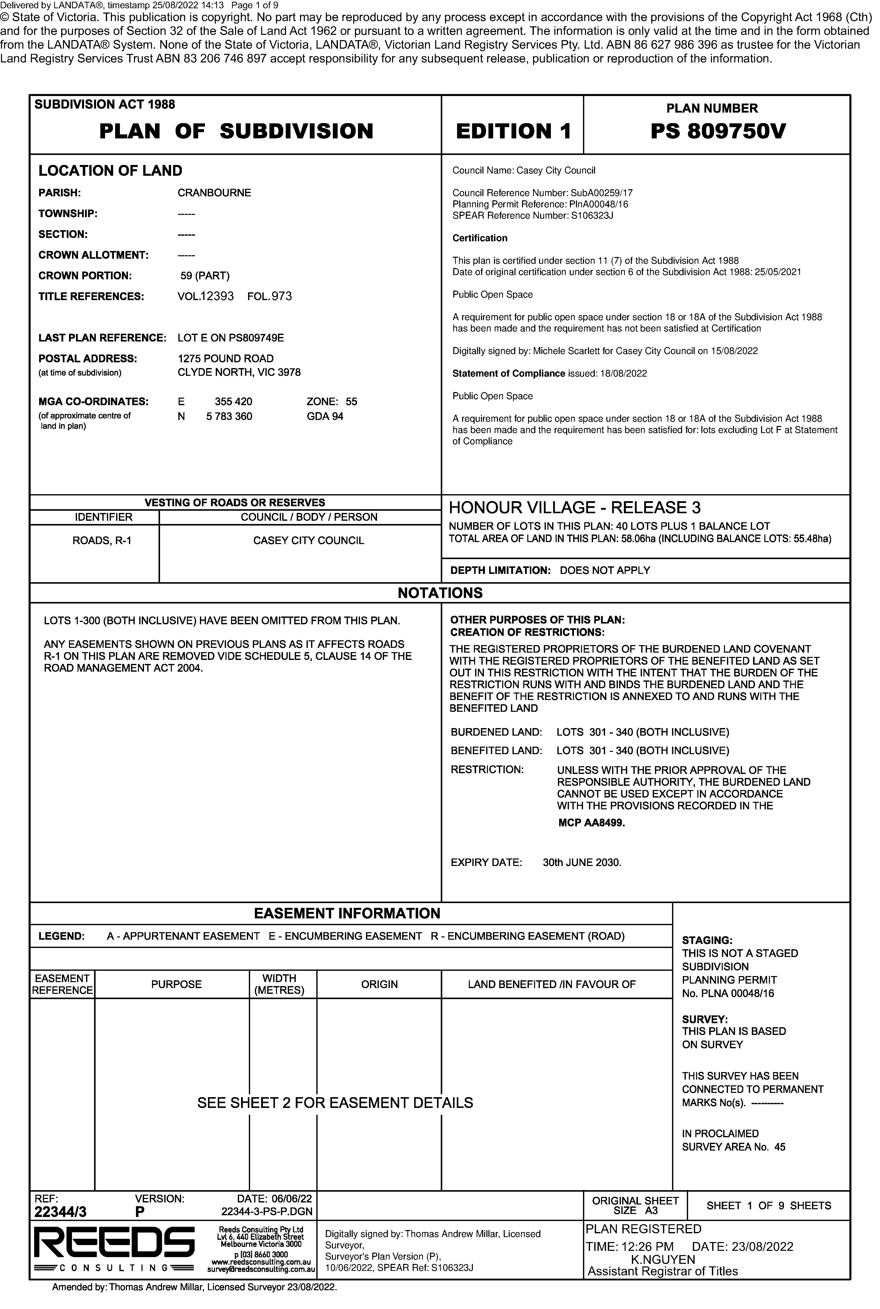
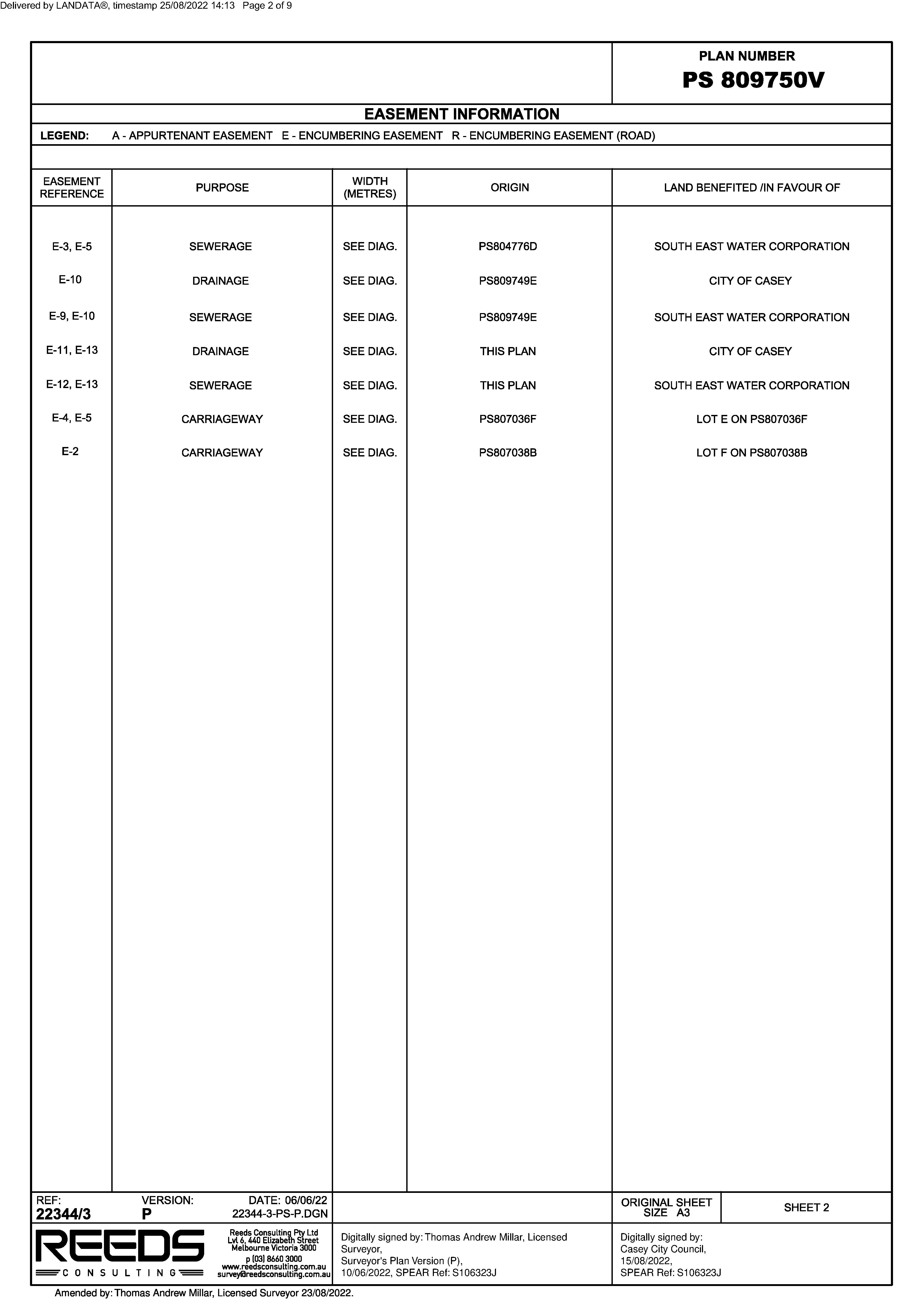
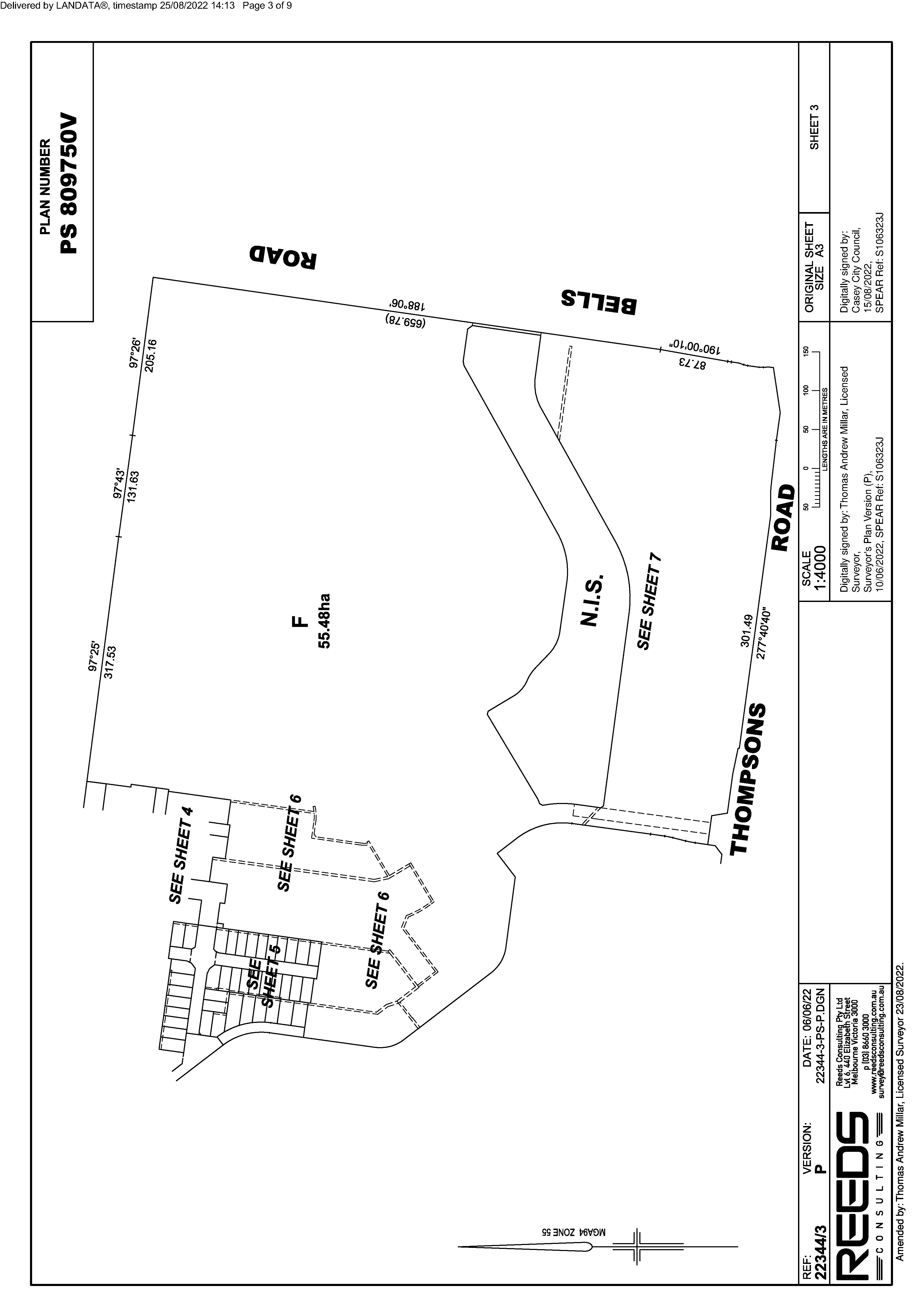
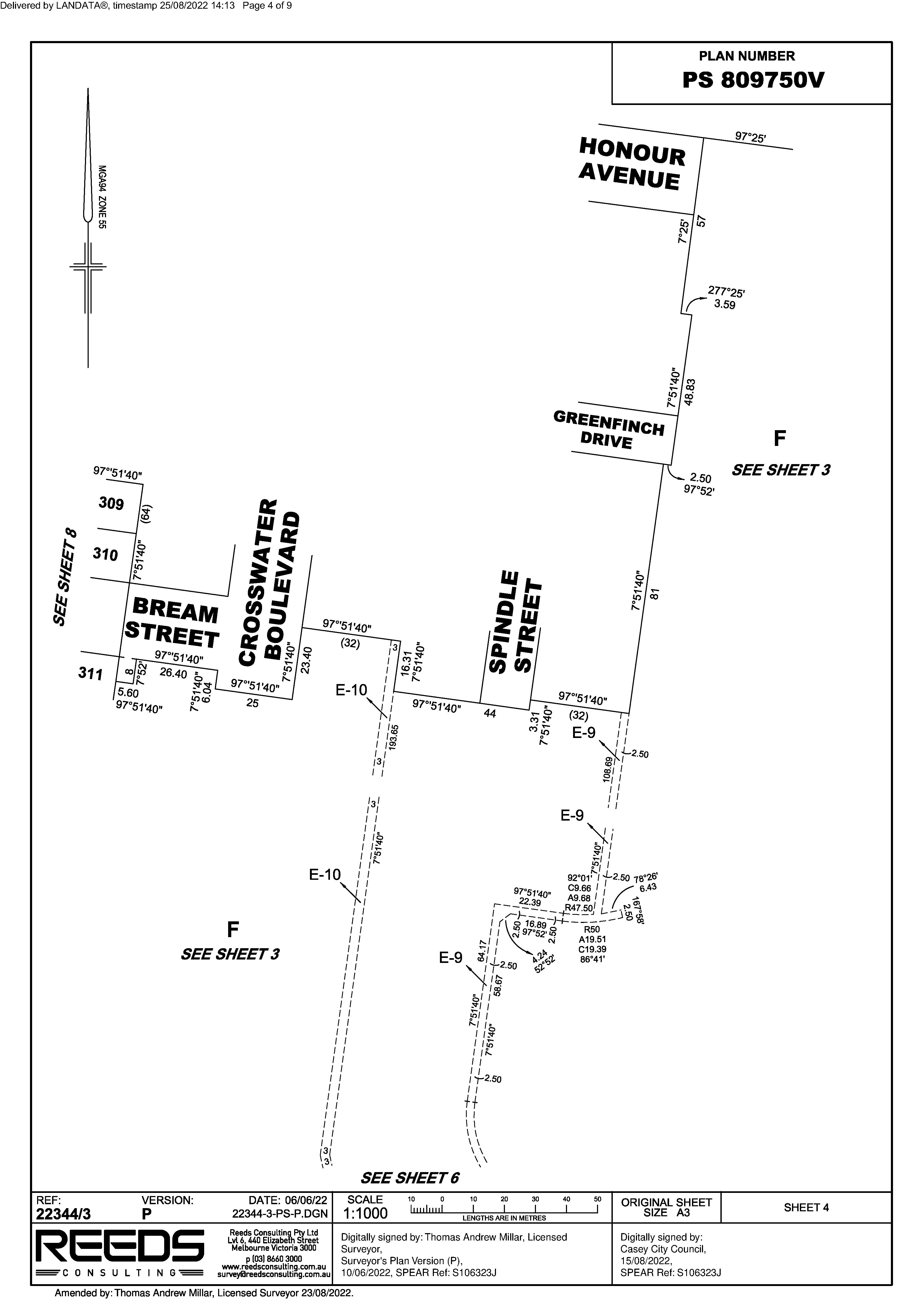
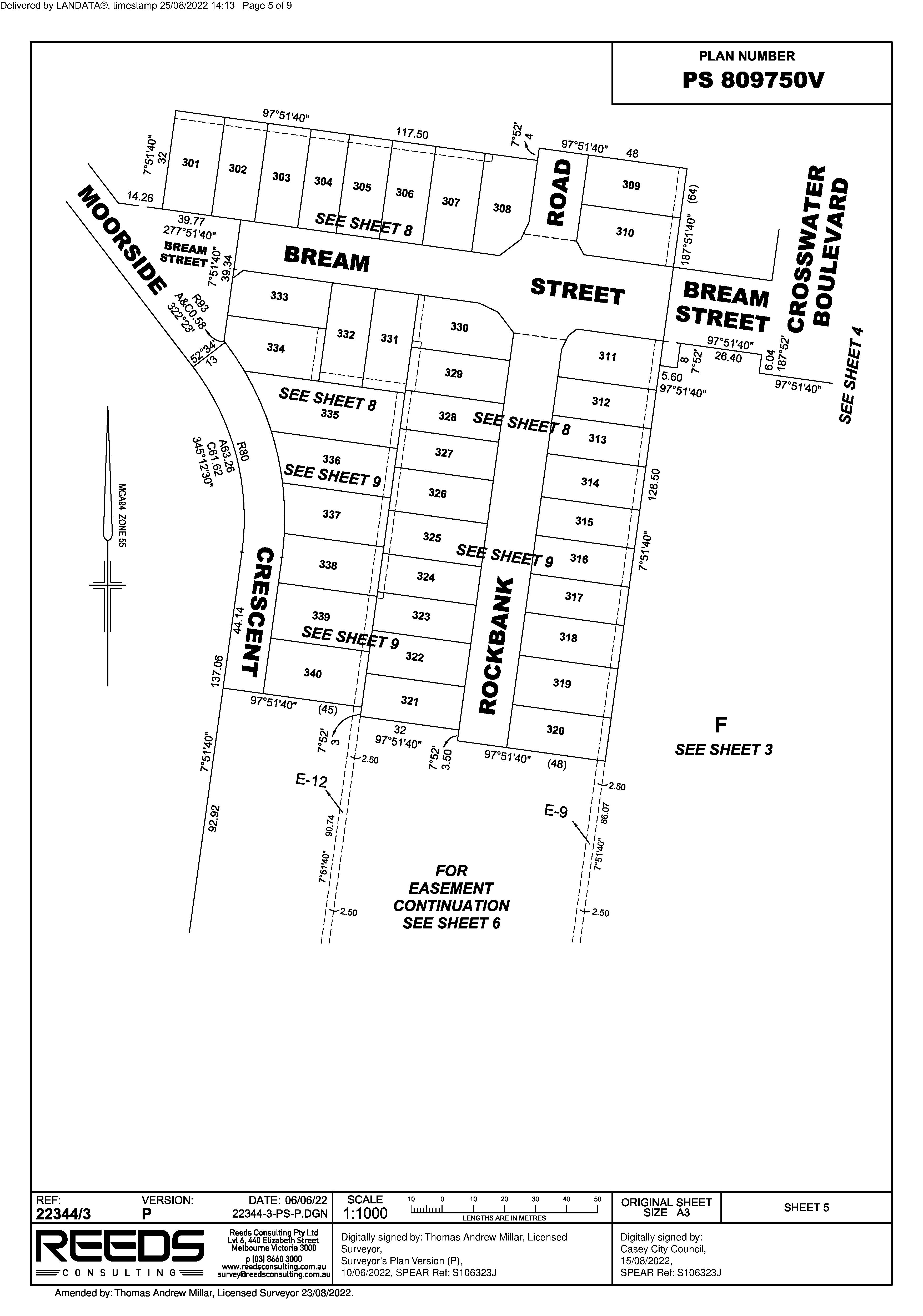
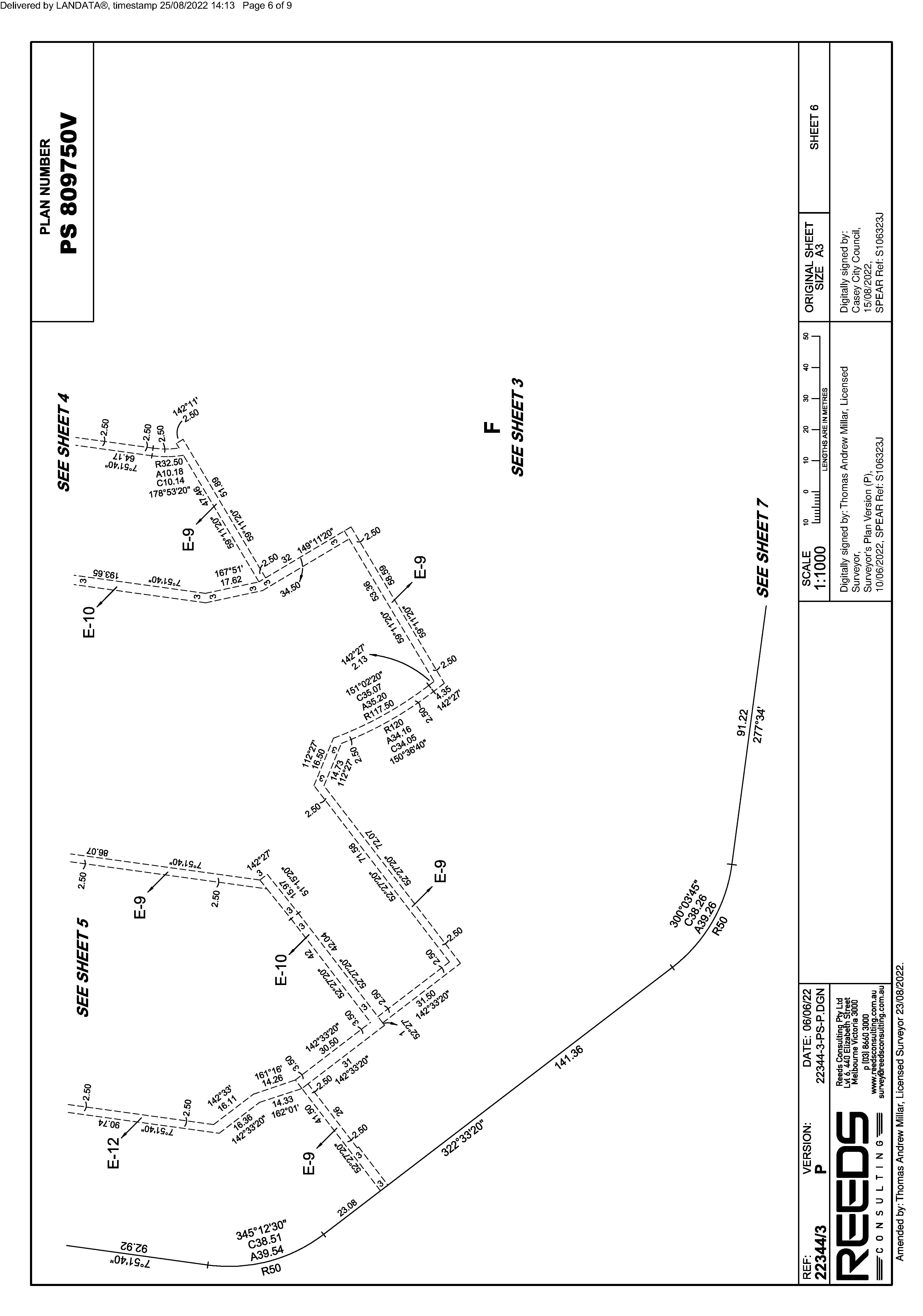
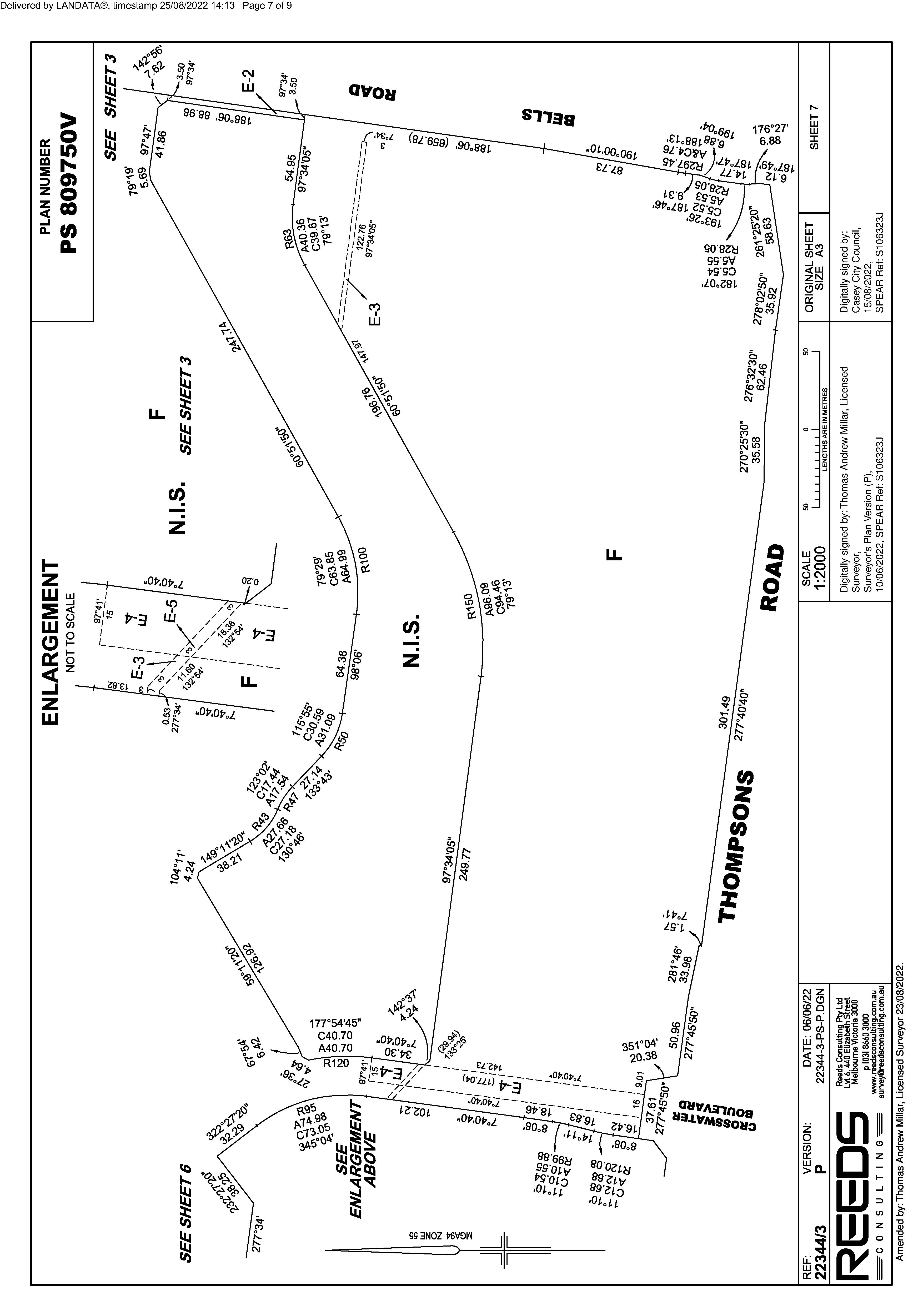
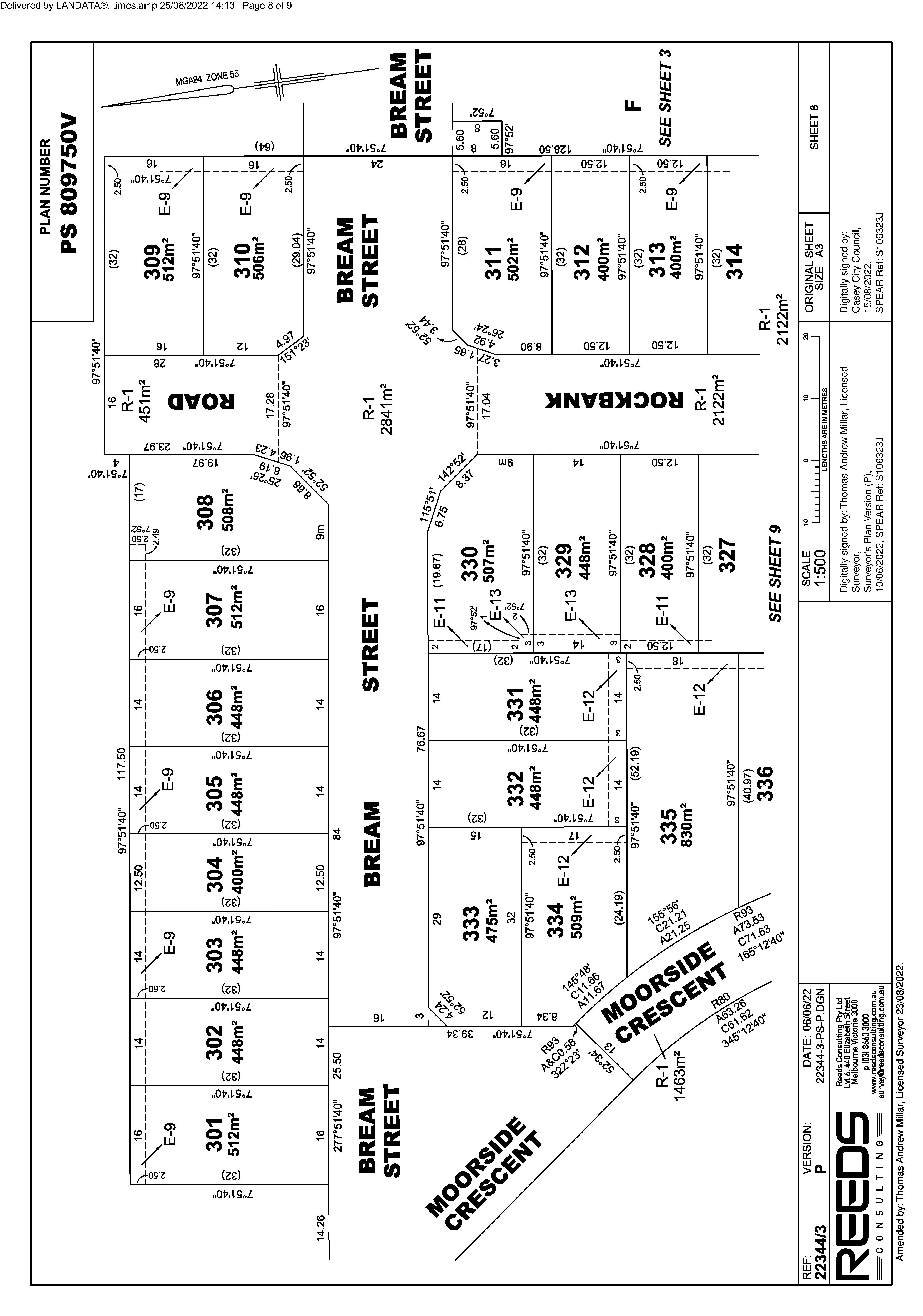
The document is invalid if this cover sheet is removed or altered.
Document Type Instrument
Document Assembled 25/08/2022 10:28
Document Identification AH336996N

Copyright and disclaimer notice: © State of Victoria. This publication is copyright. No part may be reproduced by any process except in accordance with the provisions of the Copyright Act 1968 (Cth) and for the purposes of Section 32 of the Sale of Land Act 1962 or pursuant to a written agreement. The information is only valid at the time and in the form obtained from the LANDATA® System. None of the State of Victoria, LANDATA®, Secure Electronic Registries Victoria Pty Ltd (ABN 86 627 986 396) as trustee for the Secure Electronic Registries Victoria Trust (ABN 83 206 746 897) accept responsibility for any subsequent release, publication or reproduction of the information.
Number of Pages (excluding this cover sheet) 3
Imaged Document Cover Sheet
The document following this cover sheet is an imaged document supplied by LANDATA®, Secure Electronic Registries Victoria.
Delivered © purposes
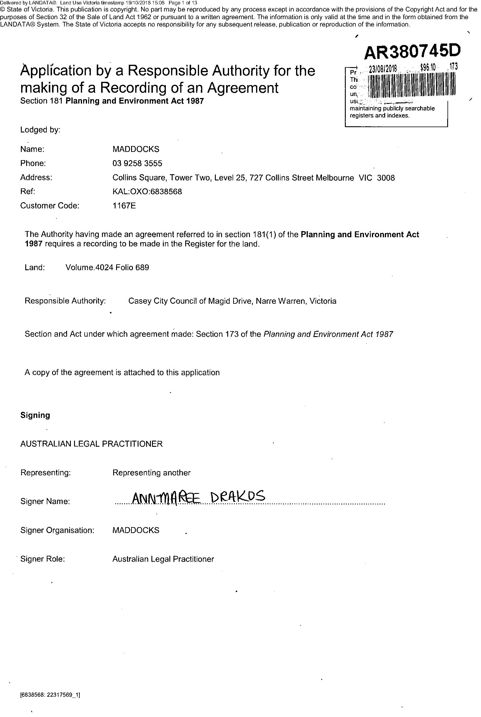
Delivered
Deltvered
Delivered
Delivered
Delivered
Delivered
Delivered
Delivered

Refer Image Instrument
Electronic Instrument Statement
Name MADDOCKS
ReferenceEmailPhoneLodgerAddressBox
Reference :TGM:7983105.001 - S1
Privacy Collection Statement
APPLICATION TO RECORD AN INSTRUMENT
Applicant(s)
VICTORIA
Date and Time Lodged 16/03/2021 06:32:50 PM
Copyright State of Victoria. This publication is copyright. No part may be reproduced by any process except in accordance with the provisions of the Copyright Act 1968 (Cth) and for the purposes of Section 32 of the Sale of Land Act 1962 (Vic) or pursuant to a written agreement. The information is only valid at the time and in the form obtained from the LANDATA REGD TM System. None of the State of Victoria, LANDATA REGD TM System, Victorian Land Registry Services Pty. Ltd. ABN 86 627 986 396 as trustee for the Victorian Land Registry Services Trust ABN 83 206 746 897 accept responsibility for any subsequent release, publication or reproduction of the information.

Jurisdiction
The information in this form is collected under statutory authority and used for the purpose of maintaining publicly searchable registers and indexes.
AddressStreet Number 0 Street Name PATRICK NORTHEAST Street Type DRIVE Locality NARRE WARREN State VIC Postcode 3805
Lodger Code 17223H
TGM:7983105.001 - S1
Instrument and/or legislation
LAND USE VICTORIA, 2 Lonsdale Street Melbourne Victoria 3000 GPO Box 527 Melbourne VIC 3001, DX 250639 ABN 90 719 052 204
Additional Details
Lodger Details
Name CASEY CITY COUNCIL
AU144110T Page 1 of 2
Department of Environment, Land, Water & Planning
Estate and/or Interest
FEE SIMPLE
RECORD - AGREEMENT - SECTION 173
Status Registered Dealing Number AU144110T
Produced 24/03/2021 04:10:45 PM
Land Title Reference 4024/689
Planning & Environment Act - section 173

ThisNIL
is a representation of the digitally signed Electronic Instrument or Document certified by Land Use Victoria. Statement End.
Department of Environment, Land, Water & Planning
Electronic Instrument Statement
The applicant requests the recording of this Instrument in the Register.
ABN 90 719 052 204 AU144110T Page 2 of 2
LAND USE VICTORIA, 2 Lonsdale Street Melbourne Victoria 3000 GPO Box 527 Melbourne VIC 3001, DX 250639
2. The Certifier holds a properly completed Client Authorisation for the Conveyancing Transaction including this Registry Instrument or Document.
Reference :TGM:7983105.001 - S1
File Notes:
4. The Certifier has taken reasonable steps to ensure that this Registry Instrument or Document is correct and compliant with relevant legislation and any Prescribed Requirement. Executed on behalf of CASEY CITY COUNCIL Signer Name KRISTIN RICHARDSON Signer Organisation PARTNERS OF MADDOCKS Signer Role AUSTRALIAN LEGAL PRACTITIONER Execution Date 16 MARCH 2021
1. The Certifier has taken reasonable steps to verify the identity of the applicant or his, her or its administrator or attorney.
Execution
3. The Certifier has retained the evidence supporting this Registry Instrument or Document.
Document Identification AU144110T
The document following this cover sheet is an imaged document supplied by LANDATA®, Victorian Land Registry Services.
Number of Pages (excluding this cover sheet) 32
Document Type Instrument
Document Assembled
The document is invalid if this cover sheet is removed or altered.
Imaged Document Cover Sheet
© State of Victoria. This publication is copyright. No part may be reproduced by any process except in accordance with the provisions of the Copyright Act 1968 (Cth) and for the purposes of Section 32 of the Sale of Land Act 1962 or pursuant to a written agreement. The information is only valid at the time and in the form obtained from the LANDATA® System. None of the State of Victoria, LANDATA®, Victorian Land Registry Services Pty. Ltd. ABN 86 627 986 396 as trustee for the Victorian Land Registry Services Trust ABN 83 206 746 897 accept responsibility for any subsequent release, publication or reproduction of the information.
Copyright and disclaimer notice:
AU144110T
Delivered by LANDATA®, timestamp 24/03/2021 16:10 Page 1 of 32
© State of Victoria. This publication is copyright. No part may be reproduced by any process except in accordance with the provisions of the Copyright Act 1968 (Cth) and for the purposes of Section 32 of the Sale of Land Act 1962 or pursuant to a written agreement. The information is only valid at the time and in the form obtained from the LANDATA® System. None of the State of Victoria, LANDATA®, Victorian Land Registry Services Pty. Ltd. ABN 86 627 986 396 as trustee for the Victorian Land Registry Services Trust ABN 83 206 746 897 accept responsibility for any subsequent release, publication or reproduction of the information.
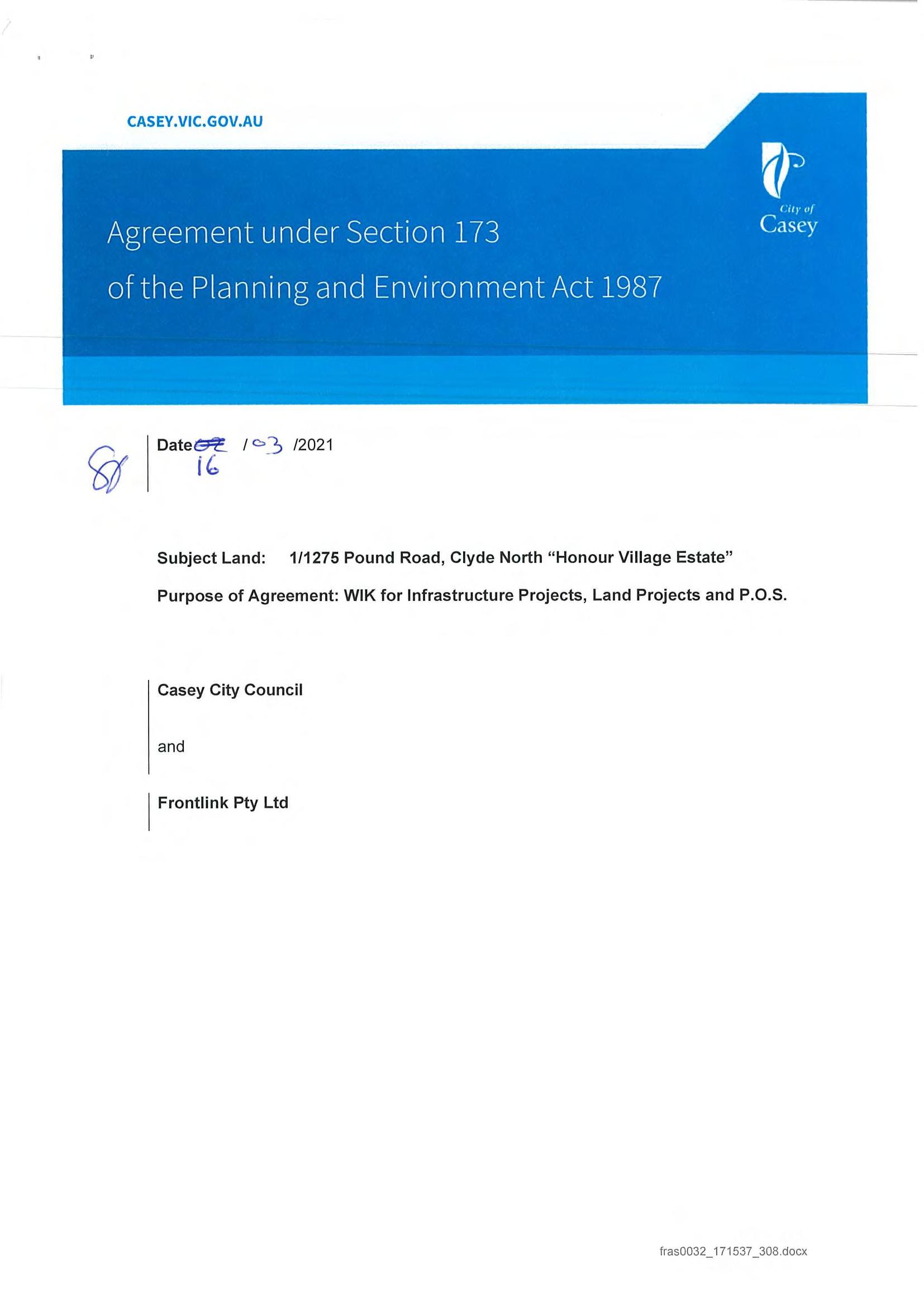
AU144110T Delivered by LANDATA®, timestamp 24/03/2021 16:10 Page 2 of 32
AU144110T Delivered by LANDATA®, timestamp 24/03/2021 16:10 Page 3 of 32
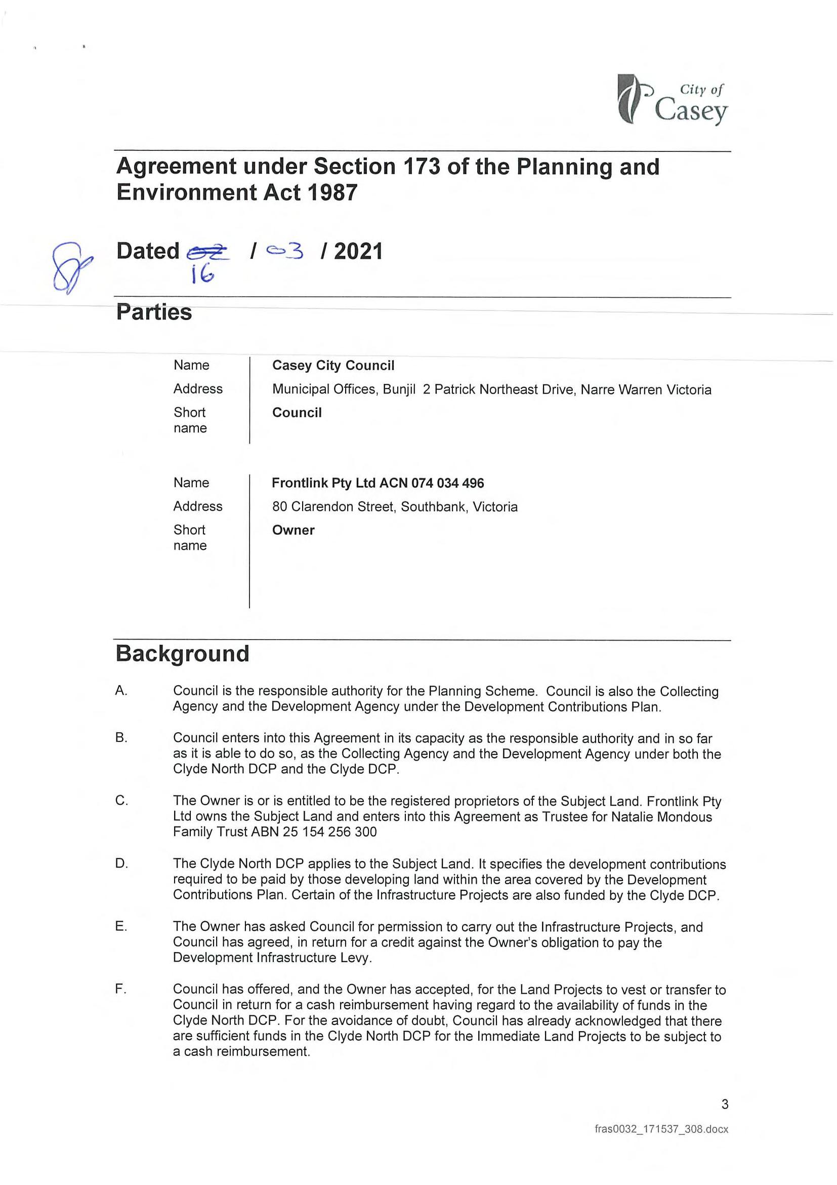
AU144110T Delivered by LANDATA®, timestamp 24/03/2021 16:10 Page 4 of 32
AU144110T Delivered by LANDATA®, timestamp 24/03/2021 16:10 Page 5 of 32
AU144110T Delivered by LANDATA®, timestamp 24/03/2021 16:10 Page 6 of 32
AU144110T Delivered by LANDATA®, timestamp 24/03/2021 16:10 Page 7 of 32
AU144110T Delivered by LANDATA®, timestamp 24/03/2021 16:10 Page 8 of 32
AU144110T Delivered by LANDATA®, timestamp 24/03/2021 16:10 Page 9 of 32
AU144110T Delivered by LANDATA®, timestamp 24/03/2021 16:10 Page 10 of 32
AU144110T Delivered by LANDATA®, timestamp 24/03/2021 16:10 Page 11 of 32
AU144110T Delivered by LANDATA®, timestamp 24/03/2021 16:10 Page 12 of 32
AU144110T Delivered by LANDATA®, timestamp 24/03/2021 16:10 Page 13 of 32
AU144110T Delivered by LANDATA®, timestamp 24/03/2021 16:10 Page 14 of 32
AU144110T Delivered by LANDATA®, timestamp 24/03/2021 16:10 Page 15 of 32
AU144110T Delivered by LANDATA®, timestamp 24/03/2021 16:10 Page 16 of 32
AU144110T Delivered by LANDATA®, timestamp 24/03/2021 16:10 Page 17 of 32
AU144110T Delivered by LANDATA®, timestamp 24/03/2021 16:10 Page 18 of 32
AU144110T Delivered by LANDATA®, timestamp 24/03/2021 16:10 Page 19 of 32
AU144110T Delivered by LANDATA®, timestamp 24/03/2021 16:10 Page 20 of 32
AU144110T Delivered by LANDATA®, timestamp 24/03/2021 16:10 Page 21 of 32

AU144110T Delivered by LANDATA®, timestamp 24/03/2021 16:10 Page 22 of 32
AU144110T Delivered by LANDATA®, timestamp 24/03/2021 16:10 Page 23 of 32
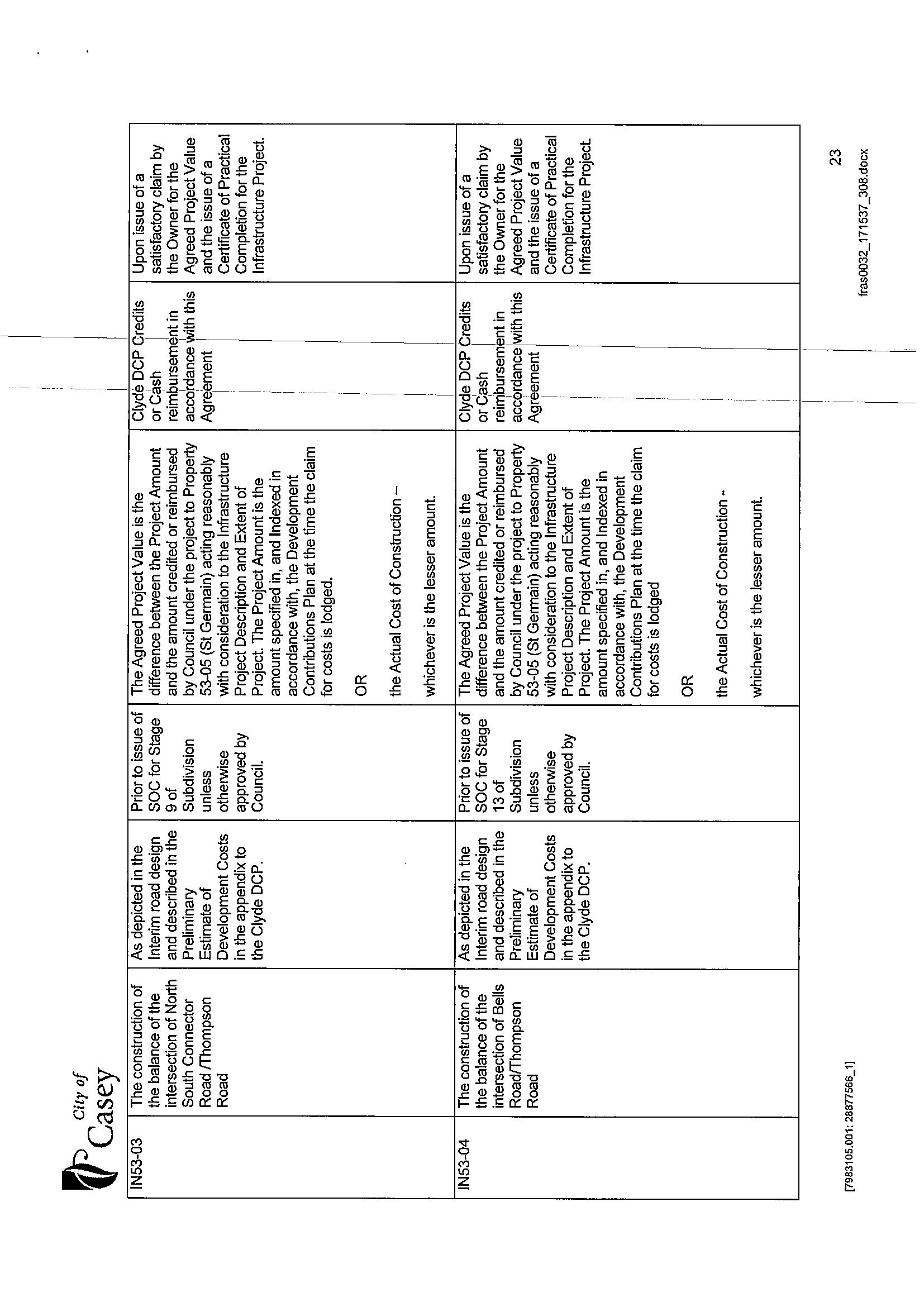
AU144110T Delivered by LANDATA®, timestamp 24/03/2021 16:10 Page 24 of 32
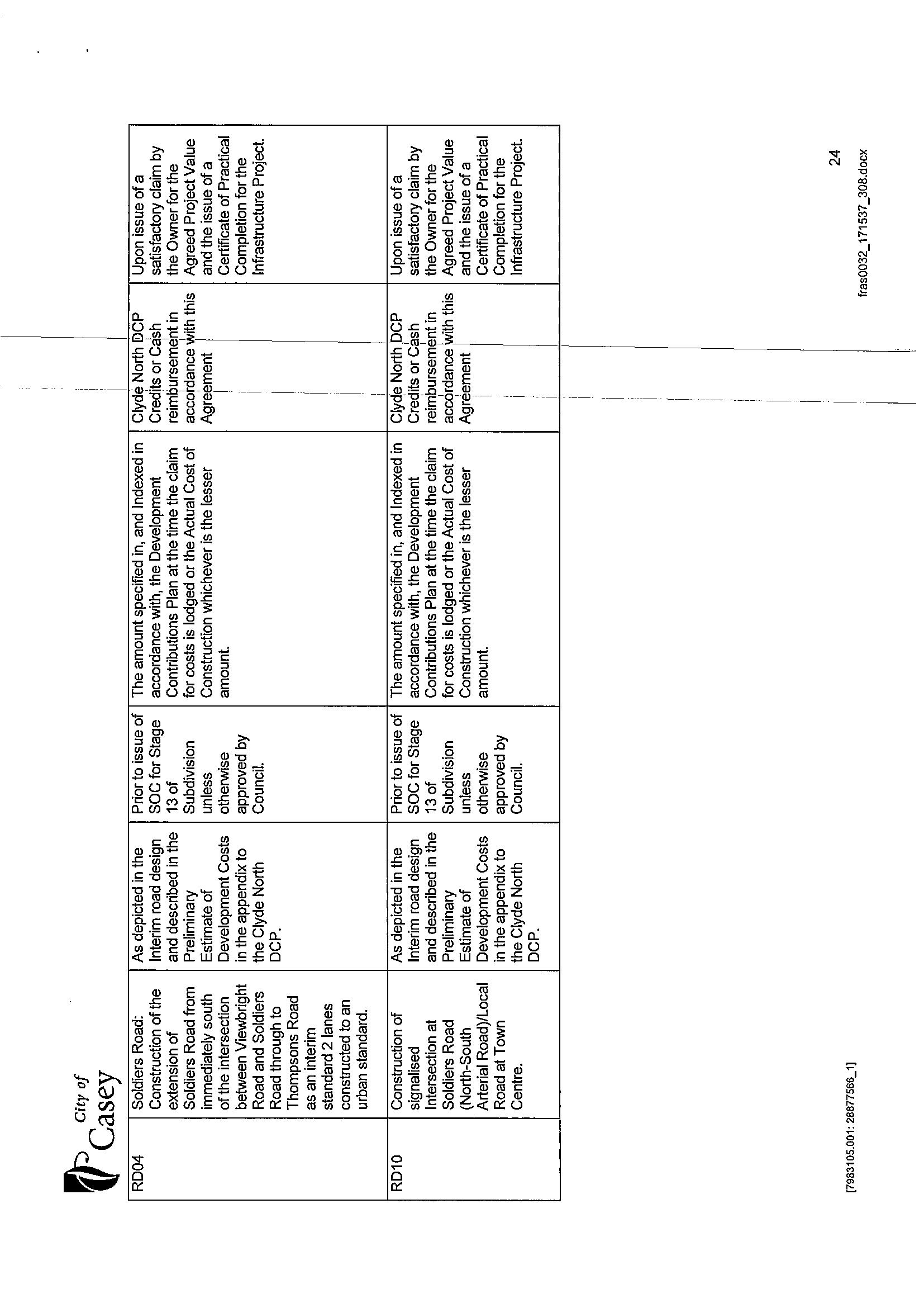
AU144110T Delivered by LANDATA®, timestamp 24/03/2021 16:10 Page 25 of 32
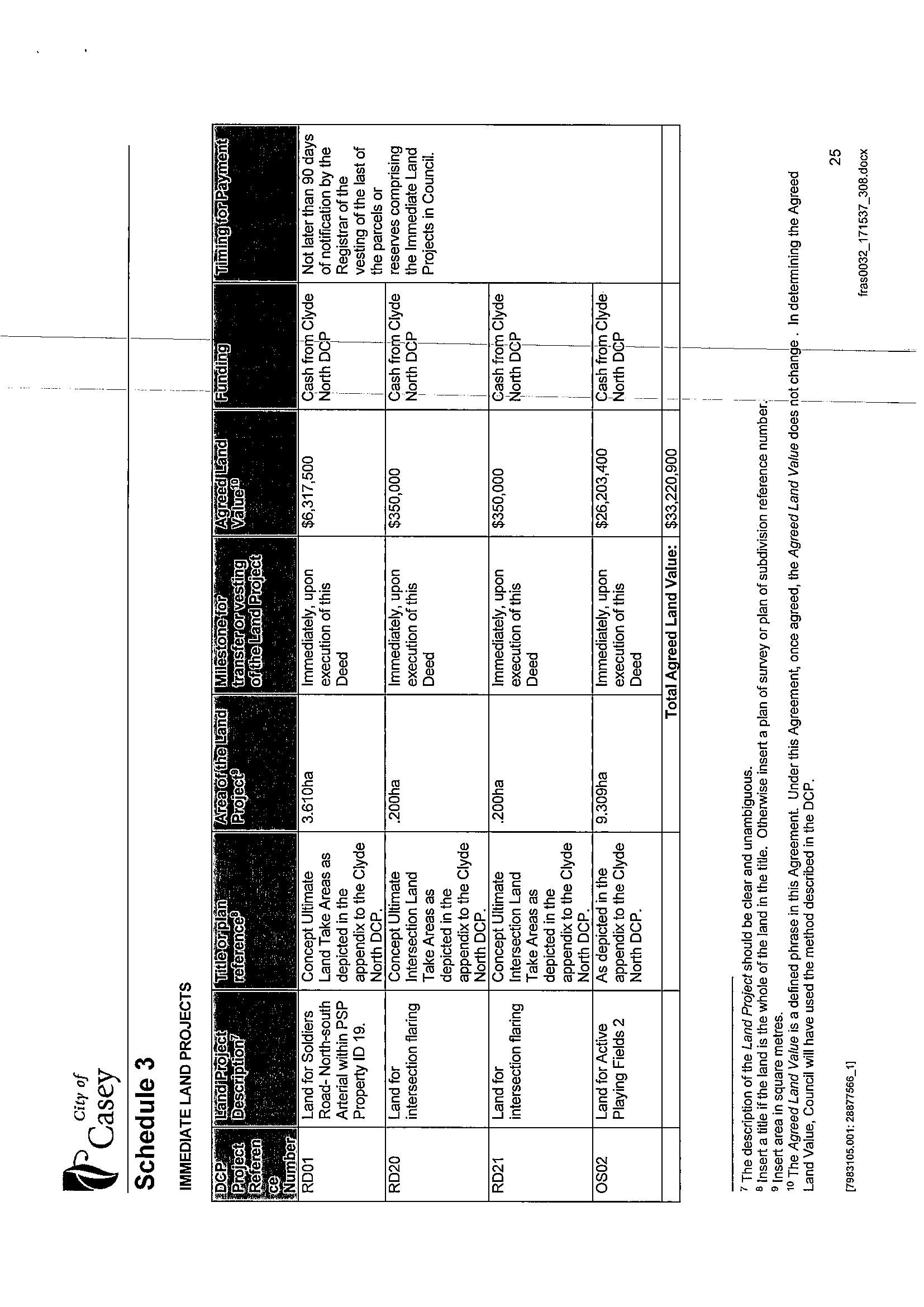
AU144110T Delivered by LANDATA®, timestamp 24/03/2021 16:10 Page 26 of 32
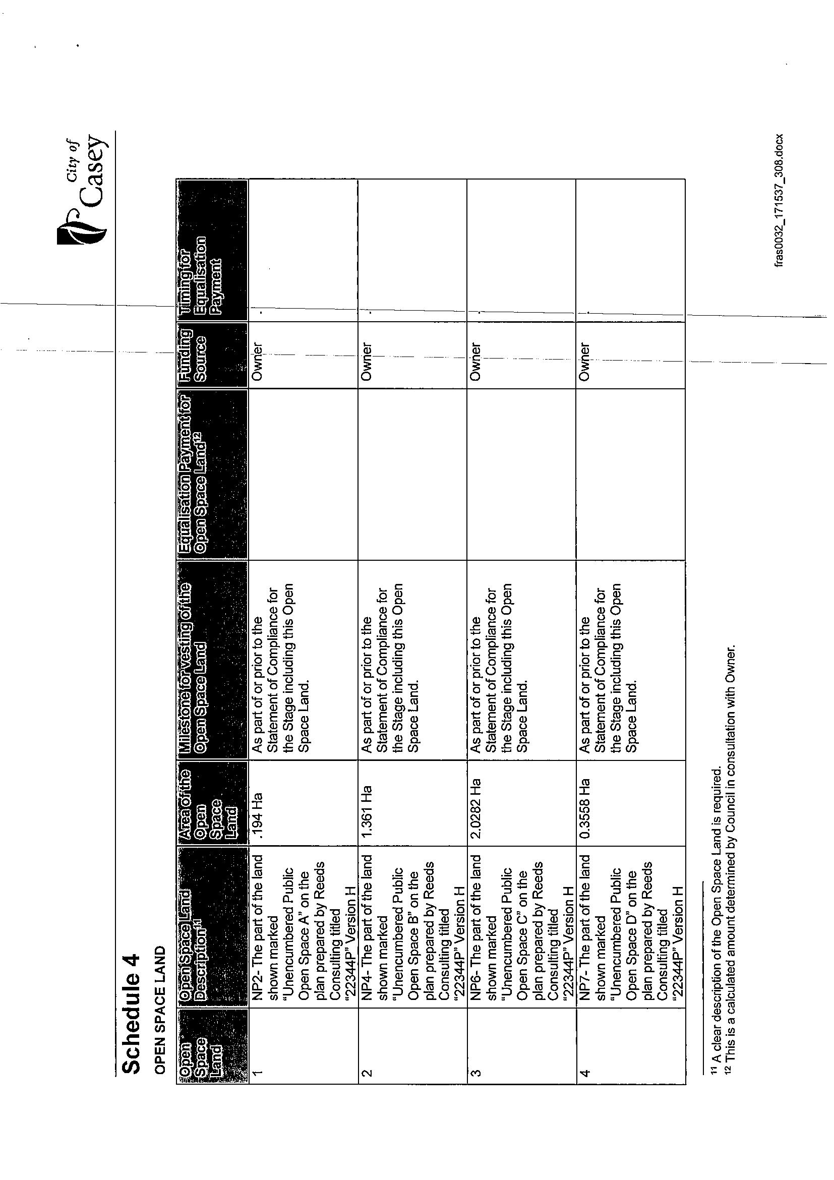
AU144110T Delivered by LANDATA®, timestamp 24/03/2021 16:10 Page 27 of 32
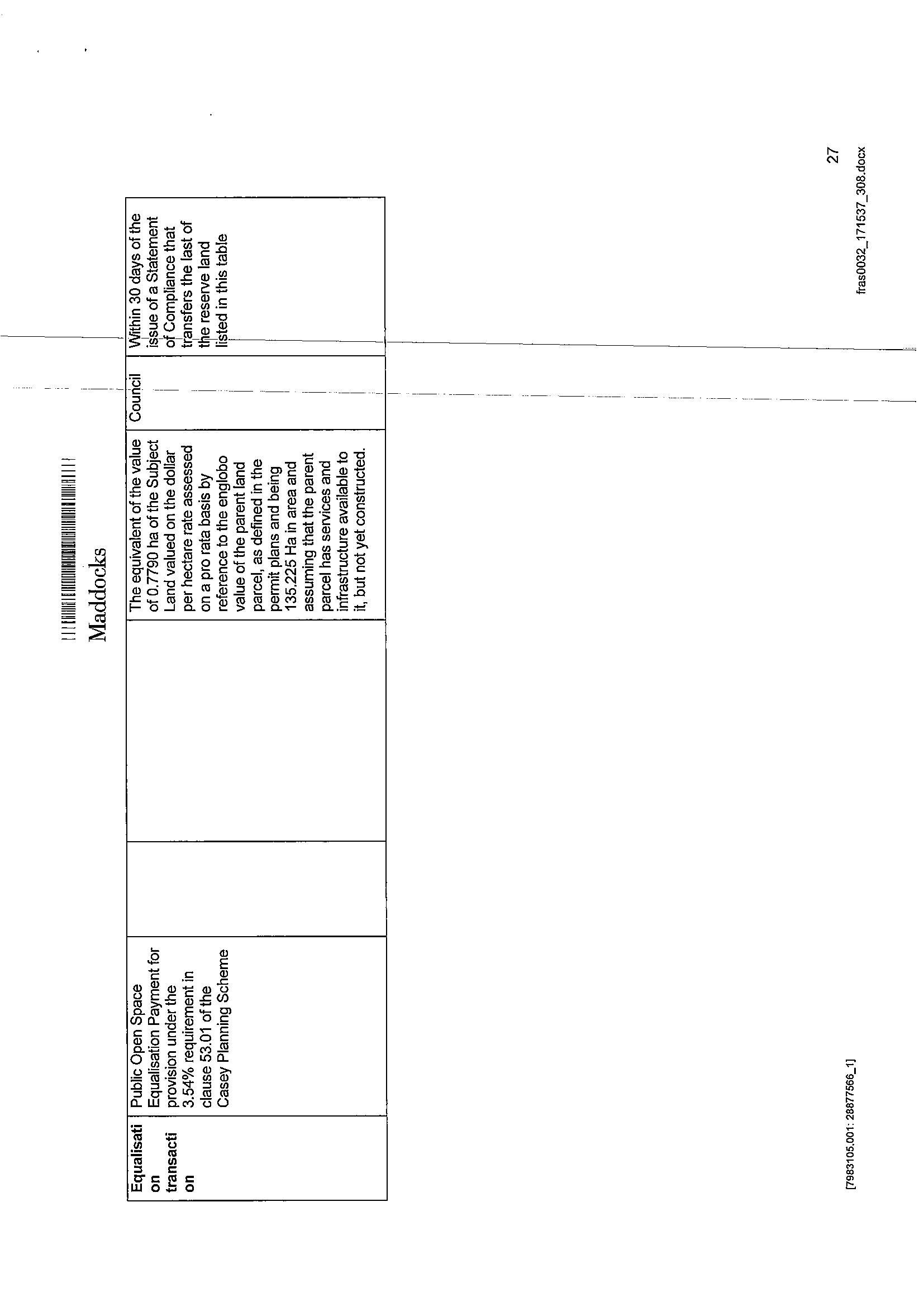
AU144110T Delivered by LANDATA®, timestamp 24/03/2021 16:10 Page 28 of 32
AU144110T Delivered by LANDATA®, timestamp 24/03/2021 16:10 Page 29 of 32
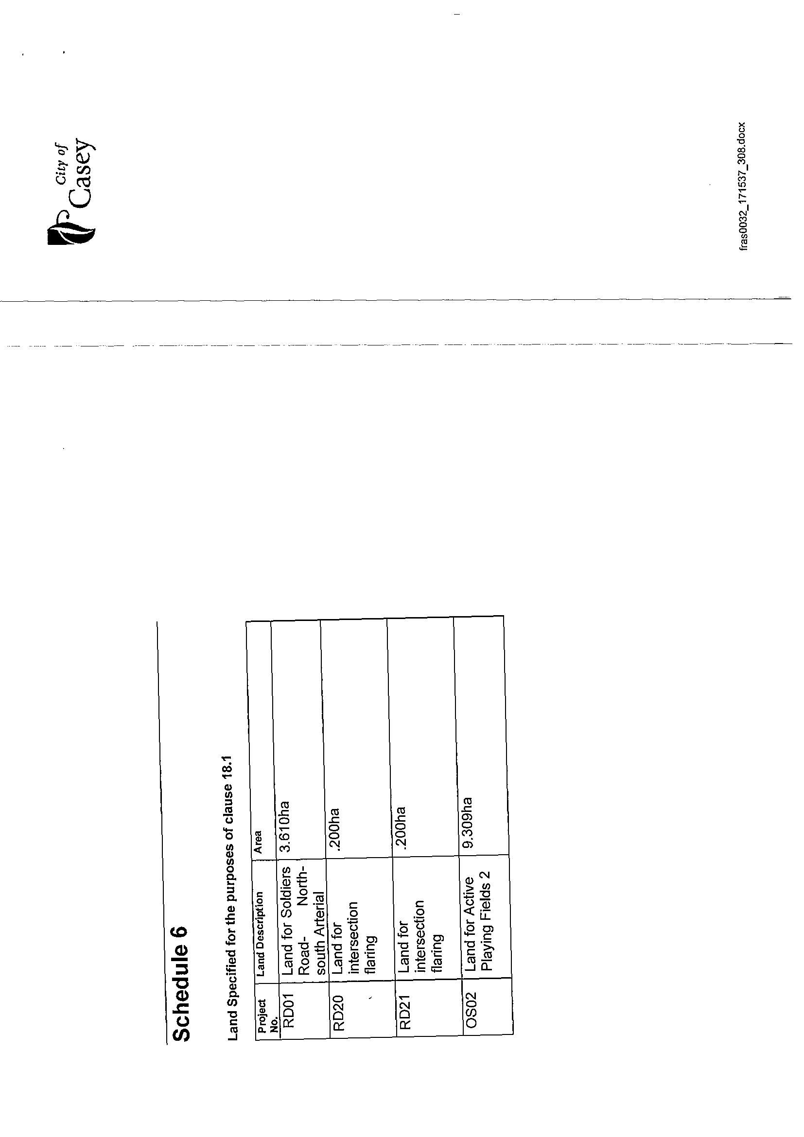
AU144110T Delivered by LANDATA®, timestamp 24/03/2021 16:10 Page 30 of 32

AU144110T Delivered by LANDATA®, timestamp 24/03/2021 16:10 Page 31 of 32

AU144110T Delivered by LANDATA®, timestamp 24/03/2021 16:10 Page 32 of 32

ROADS,R-1 CITYOFCASEY
Digitally signed by: Eleanore Margaret Doolan, Licensed Surveyor'sSurveyor, Plan Version (J), 05/08/2022, SPEAR Ref: S184583P
SOUTHSOUTHSOUTHSOUTHSOUTHSOUTHEASTWATERCORPORATIONLOTEONPS807036FCITYOFCASEYEASTWATERCORPORATIONCITYOFCASEYEASTWATERCORPORATIONEASTWATERCORPORATIONCITYOFCASEYEASTWATERCORPORATIONCITYOFCASEYEASTWATERCORPORATIONLOTLONTHISPLAN
MANAGEMENTONANYEASEMENTSSHOWNONPREVIOUSPLANSASITAFFECTSROADSR-1THISPLANAREREMOVEDVIDESCHEDULE5,CLAUSE14OFTHEROADACT2004.
RESTRICTION:BENEFITEDBURDENEDBENEFITEDBENEFITRESTRICTIONOUTTHEREGISTEREDPROPRIETORSOFTHEBURDENEDLANDCOVENANTWITHTHEREGISTEREDPROPRIETORSOFTHEBENEFITEDLANDASSETINTHISRESTRICTIONWITHTHEINTENTTHATTHEBURDENOFTHERUNSWITHANDBINDSTHEBURDENEDLANDANDTHEOFTHERESTRICTIONISANNEXEDTOANDRUNSWITHTHELAND.LAND:LOTS401-435(BOTHINCLUSIVE)LAND:LOTS401-435(BOTHINCLUSIVE)UNLESSWITHTHEPRIORAPPROVALOFTHERESPONSIBLEAUTHORITY,THEBURDENEDLANDCANNOTBEUSEDEXCEPTINACCORDANCEWITHTHEPROVISIONSRECORDEDINTHE
J
CREATIONOTHERPURPOSEOFTHISPLAN:OFRESTRICTIONNo.1
INNo.PLANNINGSUBDIVISIONTHISISNOTASTAGEDPERMITPLNA00048/16THISPLANISBASEDONSURVEYTHISSURVEYHASBEENCONNECTEDTOPERMANENTMARKSNo(s).------PROCLAIMEDSURVEYAREANo.45
MCP______ EXPIRYDATE:30thJUNE2030.
SPEAR Reference Number: S184583P
LANDLOTS1-400(BOTHINCLUSIVE)HAVEBEENOMITTEDFROMTHISPLAN.DENOTEDASN.I.S.ISNOTINSUBDIVISION.
SUBDIVISIONACT1988 PLANOFSUBDIVISION PLANNUMBER PS900709J LOCATIONOFLAND MGAPOSTALLASTTITLECROWNCROWNSECTION:TOWNSHIP:PARISH:ALLOTMENT:PORTION:REFERENCES:PLANREFERENCE:ADDRESS:CO-ORDINATES: (attimeofsubdivision) NE ZONE:55 VESTINGOFROADSORRESERVES IDENTIFIER COUNCIL/BODY/PERSON NUMBERTOTALAREAOFLANDINTHISPLAN:OFLOTSINTHISPLAN: HONOURVILLAGE-RELEASE4 DEPTHLIMITATION:DOESNOTAPPLY NOTATIONS EASEMENTINFORMATION A-APPURTENANTEASEMENTE-ENCUMBERINGEASEMENTR-ENCUMBERINGEASEMENT(ROAD)LANDBENEFITED/INFAVOUROFORIGINWIDTH(METRES)PURPOSELEGEND: SURVEY:STAGING: GDA94 COUNCILNAME: REF: 22344/4 VERSION:22344-4-PS-M-J.dwgDATE:16/06/22LICENSEDSURVEYORTHOMASANDREWMILLAR SHEET1OF9SHEETSORIGINALSHEETSIZEA3 EDITION1 (ofapproximatecentreoflandinplan) REFERENCEEASEMENT CLYDE1275LOTVOL.59CRANBOURNE(PART)FOL.KONPS900708LPOUNDROAD,NORTHVIC39783559405783100 CITYOFCASEY35+3BALANCELOTS49.13haINCLUDING46.80haBALANCELOT E-17,E-16,E-14,E-13,E-9,E-4,E-3,E-5E-5E-10E-10E-11E-12E-15E-15E-18E-18E-19E-20 CARRIAGEWAYCARRIAGEWAYSEWERAGEDRAINAGESEWERAGEDRAINAGESEWERAGESEWERAGEDRAINAGESEWERAGEDRAINAGESEWERAGE SEESEESEESEESEESEESEESEESEESEESEESEEDIAG.DIAG.DIAG.DIAG.DIAG.DIAG.DIAG.DIAG.DIAG.DIAG.DIAG.DIAG. PS812433QPS804776DPS807036FPS809749EPS809749EPS809750VPS900708LPS900708LTHISPLANTHISPLANPS900708LTHISPLAN
Council Name: Casey City Council
277°34'91.22A39.26R50C38.26300°03'40" 190°00'20"87.73 N.I.S 277°40'40"301.49 232°27'20"38.25 HONOURAVENUE GREENFINCHDRIVE SPINDLESTREETCROSSWATERBOULEVARD 59°11'20"208.78CURLEWSTREET LACEFLOWERCRESCENT 7°51'40"60.652897°51'40" 97°51'40"(45) 347°51'17.62 187°51'40"9.86 59°11'20"47.46 2.502.50 2.50 BOULEVARDCROSSWATER SPINDLESTREET 153°35'C20.15A20.17R120145°37'C13.21A13.21R120 7°51'40"13.7459°11'20" 322°33'20"141.36 CROSSWATERBOULEVARDMOORSIDECRESCENTROCKBANKROAD GREENFINCH DRIVE 7°51'40"27.672.50R30A&C1.04165°39'30" 142°27'4.352.5059°11'20"53.36 E-9 E-1033142°27'21" 59°11'20"(59.92) E-92.50178°53'20"C10.14A10.18R32.5017.50(17) 105°42'3.74 329°11'20" 59°11'20"3.50 3.50 E-15 E-9 2.50149°11'20"2.50 PLANNUMBER PS900709J ORIGINALSHEETSIZEA3REF: 22344/4 J VERSION:22344-4-PS-M-J.dwgDATE:16/06/22LICENSEDSURVEYORTHOMASANDREWMILLAR SHEET21:5000 1000100 200 LENGTHSAREINMETRES SCALE SEEENLARGEMENT1 55ZONEMGA94 SEESHEET5 SEEENLARGEMENTS2&3 97°25'317.53 M L N 30.94ha SEESHEET4 SEESHEET4 SHEETSEE9 SEESHEET3 (110.45)7°51'40" 8°06'8°06'147.66189.43 SHEETSEE9 4.30 L N 97°16'30"21.377.128°06' 97°16'30"7°16'25"107°16'30"147°41'10"8°06'52°41'24.201215.23 ENLARGEMENT3 (NOTTOSCALE) ENLARGEMENT1 (NOTTOSCALE) 97°47'14.58(23.05)52°56'8°06'8°06'142°56'97°47'7.624°07'10"9.937°47'2.50 L ENLARGEMENT2 (NOTTOSCALE) E-19 BELLSROADTHOMPSONSROAD E-20 200.76149°11'20"97°51'40"86.06149°11'20"93.04 SEESHEET3 N.I.S Digitally signed by: Eleanore Margaret Doolan, Licensed Surveyor'sSurveyor, Plan Version (J), 05/08/2022, SPEAR Ref: S184583P
PLANNUMBER PS900709J ORIGINALSHEETSIZEA31:1500 604020020 LENGTHSAREINMETRES SCALEREF: 22344/4 J VERSION:22344-4-PS-M-J.dwgDATE:16/06/22 LICENSEDSURVEYORTHOMASANDREWMILLAR SHEET3 55ZONEMGA94 5.67142°51' 7°51'40"(50.11) 88.667°50'50" 97°43' 73.19 50.03 M 5408m² 78°58'20"63.3659.4497°43' 50.0397°25' 97°26' 131.63 97°25' 201.66 HONOURAVENUE 44.38164°38' 7°25'9751'40"57.68(32)25 128.47 317.53 ENLARGEMENT L 15.32ha SEESHEET2SEESHEET4 8°06'189.43 97°25' GREENFINCH DRIVE 7°51'40" C20.12A20.25R50 SEESHEET5 977.5051'40" 7°51'40"50.867°25'1.91SEESHEET5FOREASEMENTDETAILS176°14' SHEETSEE2 (97) N E-20 142°40'9.86 410.2151°02'7°51'97°50'40"317°51'2.91A&C37.43A&C2.9997°53'92°18'20"97°25'ENLARGEMENTSEE R670.05 R670.05 NOTTOSCALE M L A&C2.9997°53' 97°51'40"149°11'20"59°11'20"149°11'59°11'20"149°11'20" 86.06 7.64 1615.1463.14 4.2452°51' SEESHEET2 R670.05 Digitally signed by: Eleanore Margaret Doolan, Licensed Surveyor'sSurveyor, Plan Version (J), 05/08/2022, SPEAR Ref: S184583P
232°27'20" 7°40'40"102.21 14°11'16.83 R95A74.98C73.05345°04' 11°10'C12.68A12.68R120.08 8°08'18.46 249.77 97°34'05" 34.304.24142°37' 7°40'40" 6.42 67°54' 27°36'4.64 5.69 79°19' R120A40.90C40.70177°54'40" R150 A96.09 C94.46 79°13' R100 79°29' C63.85 A64.99 247.74 60°51'50"322°27'20"32.29 4.24 104°11' 38.21149°11'20" R43 130°46'C27.18A27.66R47A17.54C17.44123°02'133°43'27.14R50A31.09C30.59115°55' 126.92 59°11'20" 64.38 98°06' 50.96 277°45'50"33.98 281°46' 277°45'50"37.611.577°41' 35.58 270°25'30" 62.46 276°32'20" 35.92 278°02'40" 6.12187°49'176°27'182°07'C5.54A5.55R28.056.88 14.77187°47' 193°26'C5.52A5.53R28.05 6.88199°04'188°13'A&C4.76R297.459.31187°46' 8°08'16.42 351°04'20.38 11°10'C10.54A10.55R99.88 261°25'20" 58.63 87.73190°00'10" 142.73 7°40'40" (177.02) 7°40'40" 15 97°41' E-4 E-4 54.95 R6397°34'05 A40.36 C39.67 79°13' 196.76 60°51'50"147.9797°34'05"122.76 7°40'40" 3 3 3 E-4 97°34' 0.53 132°54'11.60 132°54'18.36 7°40'40" 0.20 97°41' 15 3 E-5 E-3 7°40'40" 7°40'40" E-47°40'40"19.84 3 3 4.89 26.030°40'50" 66.547°58'50" 9.23 8°06'30.5777°35' 15 142°50'11.97 7°34'10"(15.78)7.88 188°06' E-3 171.50 76.24 PLANNUMBER PS900709J ORIGINALSHEETSIZEA31:2000 050 LENGTHSAREINMETRES SCALE 50REF: 22344/4 J VERSION:22344-4-PS-M-J.dwgDATE:16/06/22 LICENSEDSURVEYORTHOMASANDREWMILLAR SHEET4 SEESHEET2 55ZONEMGA94 SEESHEET3 N L N.I.S. N N.I.S. ENLARGEMENT (NOTTOSCALE) 52°56'9.9341.86142°56'8°06'8°06'4°07'10"7.6297°47'(23.05)EASEMENTSHEETSEE2FORDETAILS CROSSWATERBOULEVARD 277°40'40"301.49THOMPSONS ROAD BELLSROAD 200.76149°11'20"60°51'5048.02 93.04149°11'20" ENLARGEMENTSEE Digitally signed by: Eleanore Margaret Doolan, Licensed Surveyor'sSurveyor, Plan Version (J), 05/08/2022, SPEAR Ref: S184583P
GREENFINCHDRIVEHONOUR AVENUE CURLEWSTREET LACEFLOWERCRESCENT GREENFINCHDRIVEHONOURAVENUE 7°51'40" (50.11) 7.50 97°51'40" (80) 7277°51'40"277°51'40"187°51'40" 32 28 7°51'40" 97°51'40" 2.50 7°51'40"(48.83) 3.59 57 7°25' 267.50 97°25' 50.03 (110.45) 277°25' 97°43' 97°25' 317.53 7°51'40" GREENFINCH DRIVE 187°51'40" (37)0.50277°51'40" 33.68 187°51'40" 277°25'55 401 426425424 403404 423422 405406 421420 407408 419 409410411412413414415416418 417 427428429430431432435 402 433434 97°25'58 2.507°25' 97°25'46.19 3.507°25' 33.5097°25'2.503.5011.50 PLANNUMBER PS900709J ORIGINALSHEETSIZEA31:1000 5040302010010 LENGTHSAREINMETRES SCALEREF: 22344/4 J VERSION:22344-4-PS-M-J.dwgDATE:16/06/22 LICENSEDSURVEYORTHOMASANDREWMILLAR SHEET5 55ZONEMGA94 SEESHEET5 SEESHEET6 SEESHEET7 E-14 E-18E-17 E-15 SEESHEET2 N SEESHEET2 L 97°25'(97) 7°51'40" 97°51'40" 50.86 57.68 7°25'25(32) SEESHEET2 M1.917°25'E-20 50.0397°25'A&C2.9997°53'R670.05142°40'9.86142°51'5.67164°38'20"44.38 Digitally signed by: Eleanore Margaret Doolan, Licensed Surveyor'sSurveyor, Plan Version (J), 05/08/2022, SPEAR Ref: S184583P
16 14 14 16 14 17.50 14 16 16 14 97°25' 97°25' 14 448m² 401 411m² 426 412m² 425 463m² 424 512m² 403 512m² 404 465m² 423 449m² 422 448m² 405 448m² 406 451m² 421 502m² 420 448m² 407 512m² 408 419 560m² 409 512m² 410 448m² 411 448m² 412 6688m² HONOUR AVENUE 7°25'(32) (32.83) 7°51'40" 7°51'40"(32.92) 7°51'40"(33.02) 7°51'40"(33.13) 7°51'40"(33.24) 7°51'40"(33.34) 7°51'40"(33.45)7°51'40"(33.56)(33.68)7°51'40" 14 14 14 15 14 14 16 17.50 16 16 16 14 14 15 14 12.50 12.50 13.50 13.50 7°25'25 3.59 (48.83) 14 97°25' 267.50 97°25' 267.50 97°25' R-1 7°25'(32)448m² 4027°25'(32) 14 7°25'(32) 7°25'(32) 7°25'(32) 7°25'(32) 7°25'(32) 7°25'(32) 7°25'(32) 7°25'(32) 7°25'(32) 97°25' 55 426425424423422421420419 2 E-14 E-14 E-13 E-13 E-13 2.50 2.50 2.50 E-13 2.50 2.50 E-13 2.50 PLANNUMBER PS900709J ORIGINALSHEETSIZEA31:500 2010010SCALE LENGTHSAREINMETRES REF: 22344/4 J VERSION:22344-4-PS-M-J.dwgDATE:16/06/22 LICENSEDSURVEYORTHOMASANDREWMILLAR SHEET6 55ZONEMGA94 SEESHEET7 SEESHEET7 SEESEESHEET6SHEET6 Digitally signed by: Eleanore Margaret Doolan, Licensed Surveyor'sSurveyor, Plan Version (J), 05/08/2022, SPEAR Ref: S184583P
14 14 97°25' 448m² 411 448m² 412 448m² 413 512m² 414 512m² 415 448m² 416 448m² 418448m² 417 14 7°25'(32) (32)7°25' 14 14 16 (16) 97°25' 14 (14) 14 14 16 16 14 14 14 97°25'257°25' 97°25' (98.91) HONOUR AVENUE 97°25' 7°25'(32) 7°25'(32) 7°25'(32) 7°25'(32) 7°25'(32) 7°25'(32) 113.5397°25' 3.50 3 E-13 E-16 E-18 E-18 E-17 7°25' 3 97°25'46.19 3.507°25' 3.50 2.50 3.50 2.507°25' 97°25'58 2.507°25'E-14 2.50 50.03 97°25' 50.867°51'40" A&C2.99 97°53' R670.05 PLANNUMBER PS900709J ORIGINALSHEETSIZEA31:500 2010010SCALE LENGTHSAREINMETRES REF: 22344/4 J VERSION:22344-4-PS-M-J.dwgDATE:16/06/22 LICENSEDSURVEYORTHOMASANDREWMILLAR SHEET7 55ZONEMGA94 SEESEESHEET5SHEET5 SEESHEET2 LSEESHEET2 N SEESHEET2 M 7°51'40" 7°51'40" E-20 Digitally signed by: Eleanore Margaret Doolan, Licensed Surveyor'sSurveyor, Plan Version (J), 05/08/2022, SPEAR Ref: S184583P
16 14 14 16 14 17.50 14 16 16 97°25'14 97°25' 14 411m² 426 412m² 425 463m² 424 512m² 465m² 423 449m² 422 448m² 405 448m² 406 451m² 421 502m² 420 448m² 407 512m² 408 504m² 419 560m² 409 512m² 410 448m² 411 448m² 412 238m² 427 238m² 428 415m² 429 287m² 430 183m² 431 183m² 432 287m² 435 1752m² GREENFINCH DRIVE 345m² 142°52'4.247°51'40"28 7°51'40"(32.83) 7°51'40"(32.92) 7°51'40"(33.02) 7°51'40"(33.13)13.907°51'40"(33.24)142°52'4.24 4.2452°52' 7°51'40"(33.34) 7°51'40"287°51'40"28 (33.68)7°51'40"7°51'40"(33.56)7°51'40"(33.45) 10.90 14 14 15 15 15 8.508.5097°51'40" 15 25 8.50 12 8.5012.50 12.50 14 14 13.50 13.50 15 14 12.50 12.50 13.50 13.50 8.718.71 10.90 8.718.71 13.9018 7°51'40" 16 58 97°51'40" 26.50 2.50(48.83)3.5997°51'40" 163 33 3 37°51'40"1816 18 7°51'40" 97°25' 97°51'40" 109.50 32 97°51'40" 7 (80) 97°51'40" R-1 R-1 CURLEWSTREET GREENFINCH DRIVE 7°25'(32) 7°25'(32) 7°25'(32) 7°25'(32) 7°25'(32) 7°25'(32) 7°25'(32) 7°25'(32) 217°51'40"217°51'40"217°51'40"217°51'40"217°51'40" 211m² 433 10.0710.07183m² 434 8.718.71 16(37)0.5097°51'40"LACEFLOWERGREENFINCHDRIVECRESCENT 97°25' 55 97°25' 97°25' 97°25' 401402403404405406407408409410411 7°51'40"3435 97°51'40"4.24142°52'3 GREENFINCH DRIVE LACEFLOWERCRESCENT LACEFLOWER CRESCENT R-15m² 2 E-14 E-14 E-13 E-13 E-13 2.50 2.50 2.50 E-13 2.50 2.50 E-13 2.50 PLANNUMBER PS900709J ORIGINALSHEETSIZEA31:500 2010010SCALE LENGTHSAREINMETRES REF: 22344/4 J VERSION:22344-4-PS-M-J.dwgDATE:16/06/22 LICENSEDSURVEYORTHOMASANDREWMILLAR SHEET8 55ZONEMGA94 SEESHEET5 SEESHEET5 ENLARGEMENTSEE SEESHEET2 N ENLARGEMENT (NOTTOSCALE) Digitally signed by: Eleanore Margaret Doolan, Licensed Surveyor'sSurveyor, Plan Version (J), 05/08/2022, SPEAR Ref: S184583P
R120A20.18 C20.15 153°35'R120A33.39 C33.28 322°33'20"333°35'330°25'40"2559°11' 7°51'40"92.92 165°12'30"C38.52A39.54R50 (45) 97°51'40" 3187°52' 32 97°51'40" 187°52'3.50 (48) 97°51'40" 76 187°51'40" MOORSIDEROCKBANKROAD CRESCENT (35.39) 97°51'40" 232°27'20"4.795.55199°44' R120A&C12.78171°10' 105°42'71.58 52°27'20"142°33'20"29 2.50 2.502.50 3.501 3.50 32.50 3 3 3.50 2.50 2 2.50 2.50 2.5032.503 42.04 52°27'20" 15.9751°15'20"7°13'03"12.1888.71187°51'40" 142°33'20"30.5041.50 52°27'20"23.08 7°51'40"90.3216.11142°33'14.26161°16' E-9 E-9 E-10 E-9 E-11 E-12 112°27'20"9.823313142°27'52°27'20"26 52°27'20"15.50142°27'0.50 2 PLANNUMBER ORIGINALSHEETSIZEA31:750 302010010 LENGTHSAREINMETRES SCALEREF: 22344/4 J VERSION:22344-4-PS-M-J.dwgDATE:16/06/22LICENSEDSURVEYORTHOMASANDREWMILLAR SHEET9 55ZONEMGA94 BOULEVARDCROSSWATER MOORSIDECRESCENT SEESHEET2 SEESHEET2 SEESHEET2 N PS900709J Digitally signed by: Eleanore Margaret Doolan, Licensed Surveyor'sSurveyor, Plan Version (J), 05/08/2022, SPEAR Ref: S184583P
yougavewhoLtdPtyConsultingReedsfrompersonthecontactpleasedocumentthisaboutquestionsanyhaveyouIfon.reliedbenotshouldthereforeandchangeandrevisiontosubjectisItprocess.approvalSPEARtheindocumentworkingaisdocumentThis-WARNING
Digitally signed by: Michele Scarlett for Casey City Council on 22/08/2022
Council Reference Number: SubA00251/22
Certification
05/08/2022, SPEAR Ref:
This plan is certified under section 6 of the Subdivision Act 1988
Surveyor'sSurveyor, Plan
Digitally signed by: Eleanore Margaret Doolan, Licensed Version (B), S197117H
SPEAR Reference Number: S197117H
Council Name: Casey City Council
Planning Permit Reference: PlnA00048/16
pm05:3602/09/2022S197117HRef:SPEARdocument.this/SPEARtoaccess
Public Open Space
PS900630X THOMAS ANDREW MILLAR SUBDIVISION ACT 1988 PLAN OF SUBDIVISION PLAN NUMBER LOCATION OF LAND POSTALLASTTITLECROWNCROWNSECTION:TOWNSHIP:PARISH:ALLOTMENT:PORTION:REFERENCES:PLANREFERENCE:ADDRESS:MGACO-ORDINATES: (at time of subdivision) NE ZONE: 55 VESTING OF ROADS OR RESERVES IDENTIFIER COUNCIL / BODY / PERSON DEPTH LIMITATION: DOES NOT APPLY NOTATIONS EASEMENT INFORMATION A - APPURTENANT EASEMENT E - ENCUMBERING EASEMENT R - ENCUMBERING EASEMENT (ROAD) LAND BENEFITED /IN FAVOUR OFORIGIN(METRES)WIDTHPURPOSEREFERENCEEASEMENTLEGEND:REF: VERSION: .DGN DATE: SHEET 1 OF 2 SHEETS SIZE ORIGINALA3SHEET land in plan) (of approximate centre of LICENSED SURVEYOR COUNCIL NAME : EDITION GDA 2020 MARKSSURVEY:STAGING:No(s). ---------CONNECTED TO PERMANENT THIS SURVEY HAS BEEN No. PLNA PLANNING00048/16PERMIT HONOUR VILLAGE ESTATE - RELEASE 4A NUMBER OF LOTS IN THIS PLAN:ROADS, R-1 CITY OF CASEY CITY OF CASEY CLYDE1275PS900709JVOL.59CRANBOURNE(PART)FOL.LOTMPOUNDROAD,NORTH,VIC. 3978 356 050 5 783 490 ROAD MANAGEMENT ACT 2004. R-1 ON THIS PLAN ARE REMOVED VIDE SCHEDULE 5, CLAUSE 14 OF THE ANY EASEMENTS SHOWN ON PREVIOUS PLANS AS IT AFFECTS ROADS THISSUBDIVISIONISNOTA STAGED ON THISSURVEYPLANIS BASED SURVEY AREA No. 45 IN PROCLAIMED TOTAL AREA OF LAND IN THIS PLAN: 5408m² B22344/4APS 22344-4A-PS-B10/06/22
A requirement for public open space under section 18 or 18A of the Subdivision Act 1988 has not been made
Digitally signed by: Eleanore Margaret Doolan, Licensed Surveyor'sSurveyor, Plan Version (B), 05/08/2022, SPEAR Ref: S197117H
Digitally signed by: Casey City SPEAR22/08/2022,Council,Ref:S197117H
PS900630X THOMAS ANDREW MILLAR 1:1000 5040302010010 LENGTHS ARE IN METRES SCALE PLAN NUMBER REF: VERSION: .DGN DATE: SIZE ORIGINALA3SHEET SHEET 2 LICENSED SURVEYOR B22344/4APS 22344-4A-PS-B10/06/22 OAGM94ZNE55 HONOURAVENUE CHURCHILLBOULEVARD HONOUR AVENUE RA277°53'&C2.99670.05 7°51' 31 322°40'9.86 291 187°51'4 1231°02'0.21 272°18'20"A&C3743R67005277°50'40"45.0195°50' 5R-1027m² R-1 381m² 50.0397°25'7°25' 25 50.03 197°43'31.63 2797°26'3.1963.3658°58'20"277°43'59.44 277°25' questionsanyhaveyouIfon.reliedbenotshouldthereforeandchangeandrevisiontosubjectisItprocess.approvalSPEARtheindocumentworkingaisdocumentThis-WARNINGpm05:3602/09/2022S197117HRef:SPEARdocument.this/SPEARtoaccessyougavewhoLtdPtyConsultingReedsfrompersonthecontactpleasedocumentthisabout
Certification
PLAN: CREATION
RESPONSIBLE AUTHORITY, THE BURDENED LAND
pm03:0908/03/2022S109995PRef:SPEARdocument.this/SPEARtoaccess
Date of original certification under section 6: 03/12/2021
RESTRICTIONS:
WITH THE PROVISIONS RECORDED IN THE CANNOT BE USED EXCEPT IN ACCORDANCE
Digitally signed by:Thomas Andrew Millar, Licensed Surveyor'sSurveyor, Plan Version (H), 21/12/2021, SPEAR Ref: S109995P
RESTRICTION RUNS WITH AND BINDS THE BURDENED LAND AND THE OUT IN THIS RESTRICTION WITH THE INTENT THAT THE BURDEN OF THE
UNLESS WITH THE PRIOR APPROVAL OF THE
WITH THE REGISTERED PROPRIETORS OF THE BENEFITED LAND AS SET THE REGISTERED PROPRIETORS OF THE BURDENED LAND COVENANT
Public Open Space
A requirement for public open space under section 18 of the Subdivision Act 1988 has been made and the requirement has not been satisfied at Certification
H22344/5 22344-5-PS-H21/12/21
PS 812433Q THOMAS ANDREW MILLAR SUBDIVISION ACT 1988 PLAN OF SUBDIVISION PLAN NUMBER LOCATION OF LAND POSTALLASTTITLECROWNCROWNSECTION:TOWNSHIP:PARISH:ALLOTMENT:PORTION:REFERENCES:PLANREFERENCE:ADDRESS:MGACO-ORDINATES: (at time of subdivision) NECLYDE1275LOTVOL.CRANBOURNE59(PART)FOL.FPS809750VPOUNDROADNORTH39783558705783200 ZONE: 55 VESTING OF ROADS OR RESERVES ROADS,IDENTIFIERR-1 CITY OF CASEY COUNCIL / BODY / PERSON DEPTH LIMITATION: DOES NOT APPLY NOTATIONS EASEMENT INFORMATION A - APPURTENANT EASEMENT E - ENCUMBERING EASEMENT R - ENCUMBERING EASEMENT (ROAD) LAND BENEFITED /IN FAVOUR OFORIGIN(METRES)WIDTHPURPOSEREFERENCEEASEMENTLEGEND: MARKSSURVEY:STAGING:No(s). ---------CONNECTED TO PERMANENT THIS SURVEY HAS BEEN SURVEY AREA No. 45 IN PROCLAIMED GDA 94 REF: VERSION: .DGN DATE: SHEET 1 OF 10 SHEETS SIZE ORIGINALA3SHEET EDITION 1 land in plan) (of approximate centre of LICENSED SURVEYOR COUNCIL NAME : CASEY CITY COUNCIL No. PLNA THISONTHISSUBDIVISIONPLANNING00048/16PERMITISNOTASTAGEDSURVEYPLANISBASED SEE SHEET 2 FOR EASEMENT DETAILS
yougavewhoLtdPtyConsultingReedsfrompersonthecontactpleasedocumentthisaboutquestionsanyhaveyouIfon.reliedbenotshouldthereforeandchangeandrevisiontosubjectisItprocess.approvalSPEARtheindocumentworkingaisdocumentThis-WARNING
Digitally signed by: Michele Scarlett for Casey City Council on 23/02/2022
EXPIRY DATE: 30th JUNE 2030. LAND: 501 - 549 (BOTH INCLUSIVE)
HONOUR VILLAGE - RELEASE
LOTS
SPEAR Reference Number: S109995P
RESTRICTION: MCP _ _ _ _ _ _ BENEFITED LAND BENEFIT OF THE RESTRICTION IS ANNEXED TO AND RUNS WITH THE
BURDENED
Council Name: Casey City Council
BENEFITED LAND: LOTS 501 - 549 (BOTH INCLUSIVE)
Planning Permit Reference: PlnA00048/16
This plan is certified under section 11 (7) of the Subdivision Act 1988
OTHER PURPOSES OF THIS OF
Council Reference Number: SubA00325/17
5 TOTAL AREA OF LAND IN THIS PLAN: 55.48ha (INCLUDING NUMBER OF LOTS IN THIS PLAN: 49 + 1 BALANCE LOTBALANCE LOT 52.27ha) ROAD MANAGEMENT ACT 2004. R-1 ON THIS PLAN ARE REMOVED VIDE SCHEDULE 5, CLAUSE 14 OF THE ANY EASEMENTS SHOWN ON PREVIOUS PLANS AS IT AFFECTS ROADS LOTS 1-500 (BOTH INCLUSIVE) HAVE BEEN OMITTED FROM THIS PLAN
E-9,E-10E-10E-3,E-5E-4,E-5 H22344/5 22344-5-PS-H21/12/21 yougavewhoLtdPtyConsultingReedsfrompersonthecontactpleasedocumentthisaboutquestionsanyhaveyouIfon.reliedbenotshouldthereforeandchangeandrevisiontosubjectisItprocess.approvalSPEARtheindocumentworkingaisdocumentThis-WARNING
Digitally signed by: Casey City
SEE DIAG.
LAND BENEFITED /IN FAVOUR OF
Digitally signed by:Thomas Andrew Millar,
ORIGIN
A - APPURTENANT EASEMENT E - ENCUMBERING EASEMENT R - ENCUMBERING EASEMENT (ROAD)REFERENCELEGEND:EASEMENT PURPOSE
E-12E-11E-2 CARRIAGEWAYCARRIAGEWAYSEWERAGEDRAINAGESEWERAGEDRAINAGESEWERAGE
SEE DIAG.
SEE DIAG.
SEE DIAG.
SEE DIAG. SEE DIAG.
THISPS804776DPS807038BPS807036FPS809749EPS809749EPLANPS809750V
LOT F ON PS807038B
SOUTH EAST WATER CORPORATION
CITY OF CASEY
SPEAR23/02/2022,Council,Ref:S109995P
Licensed Surveyor'sSurveyor, Plan Version (H), 21/12/2021, SPEAR Ref: S109995P
EASEMENT INFORMATION (METRES)WIDTH
PS 812433Q THOMAS ANDREW MILLAR PLAN NUMBER REF: VERSION: .DGN DATE: SIZE ORIGINALA3SHEET SHEET 2 LICENSED SURVEYOR
LOT E ON PS807036F
SEE DIAG.
CITY OF CASEY
SOUTH EAST WATER CORPORATION pm03:0908/03/2022S109995PRef:SPEARdocument.this/SPEARtoaccess
SOUTH EAST WATER CORPORATION
PS 812433Q THOMAS ANDREW MILLAR PLAN NUMBER REF: VERSION: .DGN DATE: SIZE ORIGINALA3SHEET SHEET 3 LICENSED SURVEYOR 1:4000 50050 LENGTHS ARE IN METRES SCALE 100 150 H22344/5 22344-5-PS-H21/12/21 SHEET5SEE SHEET4SEE SEESHEET6 OAGM94ZNE55 52.27ha THOMPSONS ROAD HONOUR AVENUE BREAM STREET BOULEVARDCROSSWATER SPINDLESTREETMOORSIDECRESCENT ROCKBANKROAD BELLS ROAD 197°43'31.6397°25'277°40'40" 97°26' G 317.53 205.16 (65978) 188°06' 190°00'10"87.73 301.49 N.I.S. 322°33'20"(141.36) 291.2277°34'R50 CA39.2638.26 300°03'45" questionsanyhaveyouIfon.reliedbenotshouldthereforeandchangeandrevisiontosubjectisItprocess.approvalSPEARtheindocumentworkingaisdocumentThis-WARNINGpm03:0908/03/2022S109995PRef:SPEARdocument.this/SPEARtoaccessyougavewhoLtdPtyConsultingReedsfrompersonthecontactpleasedocumentthisabout
Digitally
Digitally
signed by:Thomas Andrew Millar, Licensed Surveyor'sSurveyor, Plan Version (H), 21/12/2021, SPEAR Ref: S109995P
signed by: Casey City SPEAR23/02/2022,Council,Ref:S109995P
PS 812433Q THOMAS ANDREW MILLAR PLAN NUMBER 1:1000 5040302010010REF: VERSION: .DGN DATE: SIZE ORIGINALA3SHEET LENGTHS ARE IN METRES SCALE SHEET 4 LICENSED SURVEYOR H22344/5 22344-5-PS-H21/12/21 SEE SHEET 3 SEESHEET7 SEESHEET7 M G A 9 4 Z O N E 5 5 DRIVE GREENFINCH HAVENUEONOUR BOULEVARDCROSSWATERSTREETBREAM STREETSPINDLE 97°25' 577°25' 23.5977°25' 48.837°51'40" 97°52'2.50 7°51'40" 97°'51'40"(32)16 97°'51'40" 16.31 7°51'40"97°'51'40"(32) (44) 3.31 7°51'40" 549 529530501 G 531 97°'51'40"26.40 6.0497°51'40"7°'51'40"257°51'40"23.40 174.94 yougavewhoLtdPtyConsultingReedsfrompersonthecontactpleasedocumentthisaboutquestionsanyhaveyouIfon.reliedbenotshouldthereforeandchangeandrevisiontosubjectisItprocess.approvalSPEARtheindocumentworkingaisdocumentThis-WARNINGpm03:0908/03/2022S109995PRef:SPEARdocument.this/SPEARtoaccess Digitally signed by:Thomas Andrew Millar, Licensed Surveyor'sSurveyor, Plan Version (H), 21/12/2021, SPEAR Ref: S109995P Digitally signed by: Casey City SPEAR23/02/2022,Council,Ref:S109995P
PS 812433Q THOMAS ANDREW MILLAR 1:1000 5040302010010 LENGTHS ARE IN METRES SCALE PLAN NUMBER REF: VERSION: .DGN DATE: SIZE ORIGINALA3SHEET SHEET 5 LICENSED SURVEYOR H22344/5 22344-5-PS-H21/12/21 SEE SHEET 3 SEE SHEET 7 SEE SHEET 7 MCRESCENTOORSIDE BOULEVARDCROSSWATER CRESCENTMOORSIDE ROADROCKBANK STREETSPINDLE E-9 E-12 E-10 E-9 E-9 E-10E-9E-9 (45)97°51'40" 3 187°51'40" 397°51'40"2 187°51'40"3.50 97°51'40"(48) 7°51'40" 7°51'40" 767°51'40" 92.92 R50 A39.54C38.51345°12'30" 9032 7°51'40" 2.50 2.50 2.50 2.50 3142°27'15.9751°15'20"3 3 52°27'20" 42 52°27'20" 42.04 3 22 14.43163°08' 142°33'20"16.66 16.11142°33'14.26161°16'3.50142°33'20"30.503.5031142°33'20"2.5052°27'20"23.08 322°33'20"(141.36) 512°27' 32.501.50 142°33'20" 2.50 2.50 52°27'20" 72.07 2.50 52°27'20" 71.58 4.35142°27' 2.50 2.50 59°11'20" 53.36 3 3 2.50 2.50 R120A13.21C13.21145°37' 22.50.5027.677°51'40" 7°51'40"2767 8101A4101C G 555555091011121314515 516 517518519520521522 540 541 542 9(35.39)7°51'40"4.79 142°27'3.74105°42'R120 R120 CA20.1720.15153°35' A12.78C12.78171°10' 5.5519°44' 59°11'20" 149°11'20"17.62167°51'7°51'40"60.65 97°51'40"289.867°51'40" 97°51'40"(45) 41.50 52°27'20" (59.92) 149°11'20" 59°11'20" 58.59 (17) 2.50 2.50 59°11'20" 47.46 59°11'20" 49.24 0523R023°8715 133 219.8212°27' 3 3 2.50 26 17.50 13.50 questionsanyhaveyouIfon.reliedbenotshouldthereforeandchangeandrevisiontosubjectisItprocess.approvalSPEARtheindocumentworkingaisdocumentThis-WARNINGpm03:0908/03/2022S109995PRef:SPEARdocument.this/SPEARtoaccessyougavewhoLtdPtyConsultingReedsfrompersonthecontactpleasedocumentthisabout
Digitally signed by:Thomas Andrew Millar, Licensed Surveyor'sSurveyor, Plan Version (H), 21/12/2021, SPEAR Ref: S109995P
Digitally signed by: Casey City SPEAR23/02/2022,Council,Ref:S109995P
Digitally signed by: Andrew Millar, Surveyor'sSurveyor, Version (H), Ref: S109995P
Casey City SPEAR23/02/2022,Council,Ref:S109995P
21/12/2021, SPEAR
PS 812433Q THOMAS ANDREW MILLAR 1:2000 050 LENGTHS ARE IN METRES SCALE 50 PLAN NUMBER REF: VERSION: .DGN DATE: SIZE ORIGINALA3SHEET SHEET 6 LICENSED SURVEYOR H22344/5 22344-5-PS-H21/12/21 SEE SHEET 3 SEE SHEET 3 ENLARGEMENTABOVESEE SEE SHEET 3 OAGM94ZNE55 BELLS ROAD THOMPSONS ROAD BOULEVARDCROSSWATER N.I.S. E-2 ENLARGEMENT NOT TO SCALE E-3 N.I.S. E-5 E4 391357°41' 104°11' 59°11'20"126.9267°54' 27°36' 4.24 6.42 4.64 177°54'45"C4070A4070R120 3430 7°40'40" 9249.777°34'05" R15079°13'C94.46A96.09 60°51'50" (17704) 14273 7°4040" 2301.4977°40'40" 35.58 62.46 35.92 58.63 1.57 7°41'33.98 50.96 20.38237.6177°45'50" 277°45'50"351°04' 281°46' 247.74 60°51'50" 497°47'1.8675.699°19' 7.62 3149°11'20"8.21 79°29'C63.85A64.99R100964.388°06'R50A31.09C30.59115°55'27.14 R133°43'47A17.54C17.44R431CA27.6627.1830°46' (659.78) 8773 A&C476R297459.31 6.88R28.0555A5455C 612 176°27'688 1477R2805 C5.52A5.53 4.24142°37' 187°49'187°47'182°07' 193°26' 187°46' 188°13'199°04' 190°00'10" 188°06' 188°06' 270°25'30" 276°32'30" 278°02'50" 261°25'20" 9.011516428°08'R1200811°10'C1268A12.68 16.8314°11'R9988 18468°08'A10.55C10.5411°10' A7°40'40"10221R9574.98C73.05345°04' 38.25 32.29232°27'20" 277°34' 322°27'20" G G 132°54'(29.96) 196.76 97°34'05"54.95 8898 142°56' 98°06'3.50 93.508°06'R63 147.97 97°34'05"122.76 7°34'3 A40.36C39.6779°13' 7°40'40" 3 3 3 E-4 277°34'0.53 132°54'11.60 132°54'18.36 7°40'40" 020 97°41'15 3 G E4 123°02' questionsanyhaveyouIfon.reliedbenotshouldthereforeandchangeandrevisiontosubjectisItprocess.approvalSPEARtheindocumentworkingaisdocumentThis-WARNINGpm03:0908/03/2022S109995PRef:SPEARdocument.this/SPEARtoaccessyougavewhoLtdPtyConsultingReedsfrompersonthecontactpleasedocumentthisabout
Licensed
Plan
Digitally signed by:
Thomas
THOMAS ANDREW MILLAR PLAN NUMBER 1:1000 5040302010010REF: VERSION: .DGN DATE: SIZE ORIGINALA3SHEET LENGTHS ARE IN METRES SCALE SHEET 7 LICENSED SURVEYOR PS 812433Q H22344/5 22344-5-PS-H21/12/21 SEE SHEET 3 SEESHEET8 SEESHEET9 SEESHEET9 SEESHEET8 SEE SHEET 3 SSEEHEET4 SEE SHEET 5 SEE SHEET 5 SEESHEET5 SEESHEET10 M G A 9 4 Z O N E 5 5 BOULEVARD CROSSWATER STREET SPINDLE HELIOSTREET BREAM STREET BOULEVARDCROSSWATER STREETSPINDLE ROCKBANKROAD CRESCENT LACEFLOWER CRESCENT LACEFLOWER 516 551718555131415511512507508509510 555550203040506501 530 527528529 553153253334 554948 554454554654743 541 542553738539540519520521522523524525526 553536 542543 E-9 OLEBWGASEEENLREMENT ENLARGEMENT NOT TO SCALE 23.407°51'40" 32 97°51'40" 97°51'40" 3.317°51'40" 32 97°51'40"7°51'40"82°57'A&C7.71R507°51'40"34.84 97°51'40" 9(35.39)7°51'40" 97°51'40" 7°51'40"6.04 25 97°51'40" 174.94 G 76187°51'40" 128.507°51'40" 87°52' 97°52' 926.407°51'40" 187°51'40"16.319.86 167°51'17.62 149°11'20" 60.65 7°51'40" 59°11'20" (59.92) 7°51'40" (48) 28 97°51'40" (45) 560 G (44) (17) (16.04)351°47' A82°57'&C7.71R50 77°01' A&C2.64 R50 2.50167°58' 16.04 351°47' yougavewhoLtdPtyConsultingReedsfrompersonthecontactpleasedocumentthisaboutquestionsanyhaveyouIfon.reliedbenotshouldthereforeandchangeandrevisiontosubjectisItprocess.approvalSPEARtheindocumentworkingaisdocumentThis-WARNINGpm03:0908/03/2022S109995PRef:SPEARdocument.this/SPEARtoaccess Digitally signed by:Thomas Andrew Millar, Licensed Surveyor'sSurveyor, Plan Version (H), 21/12/2021, SPEAR Ref: S109995P Digitally signed by: Casey City SPEAR23/02/2022,Council,Ref:S109995P
PS 812433Q THOMAS ANDREW MILLAR 1:500 2010010SCALE LENGTHS ARE IN METRES PLAN NUMBER REF: VERSION: .DGN DATE: SIZE ORIGINALA3SHEET SHEET 8 LICENSED SURVEYOR H22344/5 22344-5-PS-H21/12/21 SEE SHEET 9 SEE SHEET 9 SEESHEET3 49AGM Z ENO 55 5444448m²00m²00m²48m²76m²467m² 4554m²00m²448m²512m² 350m² 2238m²38m²350m² 44448m²00m²48m²400m²448m²400m²520m² 415m²475m²475m²400m² 4392m²15m² LACEFLOWERCRESCENTCROSSWATERBOULEVARD SPINDLESTREETHELIO STREETCROSSWATER STREETBREAM STREETSPINDLEOBULEVARDCROSSWATER 506505504503502 9997°51'40"7°51'40"97°51'40"7°51'40"97°51'40"97°51'40" 112501250144 °751'40" 18181412501250 °75140 14 8 97°52' °752' 501 16 97°51'40" 1731 97°51'40" 530 97°51'40" 1731 125014 850 12508508501250 6°751'40"89997°51'40"287°51'40"287°51'40"28812505011164250°751'40"9997°51'40"7°51'40"7°51'40"°751'40"6091 527528529 53453153253316 28 97°51'40" 16 97°51'40" 549 14 997°51'40"7°51'40"112504 548 1250 97°51'40"97°51'40"97°51'40"97°51'40"114250141250°751'40"8986 544545546547 111250412504 1368 4.24 R34 87°26' 12 142°52'3 3 16 °751'40" 4.24142°52'3 316°751'40" 97°51'40" 543 144416.04 171°47' 25 54 537 452°52'.243 97°51'40" 16°751'40" 3 524 15 25 121250 3 34.24142°52' 997°51'40"287°51'40"2812507°51'40" 97°51'40" 54 97°51'40" 526525 535536 52°52'143 3 12 4.24 (8) °751'40"12850 604 187°51'40" 97°51'40"25 °7174945140 5.60 26.40 °7234051'40" 1631 187°51'40" °751'40" 17815(32)(32)(32)(32)(32)(32) (29)(32)(32)(32)(32)(32)(32)(29) 16.89 (32)(32)(32)(32)(32)(32)(32) (C12.32)(A12.38) °751'40"507 G 561m²R-1 978m²R-1 6290m²R-1 E-11E-11 E-10E-10E-10 E-9E-9E-92286m²R-1 3 97°52'22752 33 2.502.502.502.5044 331 32222 questionsanyhaveyouIfon.reliedbenotshouldthereforeandchangeandrevisiontosubjectisItprocess.approvalSPEARtheindocumentworkingaisdocumentThis-WARNINGpm03:0908/03/2022S109995PRef:SPEARdocument.this/SPEARtoaccessyougavewhoLtdPtyConsultingReedsfrompersonthecontactpleasedocumentthisabout Digitally signed by:Thomas Andrew Millar, Licensed Surveyor'sSurveyor, Plan Version (H), 21/12/2021, SPEAR Ref: S109995P Digitally signed by: Casey City SPEAR23/02/2022,Council,Ref:S109995P
PS 812433Q THOMAS ANDREW MILLAR 1:500 2010010SCALE LENGTHS ARE IN METRES PLAN NUMBER REF: VERSION: .DGN DATE: SIZE ORIGINALA3SHEET SHEET 9 LICENSED SURVEYOR H22344/5 22344-5-PS-H21/12/21 49AGM Z ENO 55 4400m²00m²512m²448m²448m²400m²576m² 520m² 505m² 479m² 415m²392m² 2238m²38m²512m²512m²512m²475m²448m² SEE SHEET 5 FORDETAILSEASEMENT SEE SHEET 3 SEE SHEET 3 SEE SHEET 8 SEE SHEET 8 SEE SHEET 8 SEE SHEET 10 LACEFLOWERCRESCENTCROSSWATER SPINDLEHELIO STREET COBULEVARDROSSWATER SSTREETPINDLE 97°51'40" 511 111250250451212501250 510509508507 99997°51'40"7°51'40"7°51'40"7°51'40" 125014141616 °751'40" 125014 °751'40" 14 97°51'40" 1368 4.24 R34 87°26' 12 142°52'3 3 16 75140" 4.24142°52'3 31675140" 97°51'40" 1444 34°751'40" 12 A9.16C9.1592°37' 31°751'40" 4.89 3 3 452°52'.24 916.89m7°51'40" 541 542 R50 A7.71 3484 1C7.70262°57'6.04171°47' 15 14 97°51'40" °751'40" 16 25 18504 54 9997°51'40"287°51'40"287°51'40"28 850537538539540 606516 520519 1416 97°51'40" 16521 4141252°52'.243 16169°751'40"524 14 97°51'40" 850 97°51'40" 167°51'40" 850 1675140" 3 97°51'40"522523524 15 28 67 °751'40" 97°51'40"97°51'40"(32)(32)(32)(32)(32)(32)(32) 99(29)(32)(32)(32)7°51'40"(32)7°51'40"(32) 16.89 °75140 (C12.32)(A12.38) 1751407815 °751'40" 2586 (45) 986°751'40" 513 519 506 543 °751'40"12850 75140"3908G G 561m²R-1 978m²R-1 E-11E-11 E-10E-10 E-9 6290m²R-1 E-9 2286m²R-1 E-9333 2.502222.50 13.50 2.50 2.50 questionsanyhaveyouIfon.reliedbenotshouldthereforeandchangeandrevisiontosubjectisItprocess.approvalSPEARtheindocumentworkingaisdocumentThis-WARNINGpm03:0908/03/2022S109995PRef:SPEARdocument.this/SPEARtoaccessyougavewhoLtdPtyConsultingReedsfrompersonthecontactpleasedocumentthisabout Digitally signed by:Thomas Andrew Millar, Licensed Surveyor'sSurveyor, Plan Version (H), 21/12/2021, SPEAR Ref: S109995P Digitally signed by: Casey City SPEAR23/02/2022,Council,Ref:S109995P
signed by: Casey City SPEAR23/02/2022,Council,Ref:S109995P
signed by:Thomas Andrew Millar, Licensed Surveyor'sSurveyor, Plan Version (H), 21/12/2021, SPEAR Ref: S109995P
Digitally
Digitally
PS 812433Q THOMAS ANDREW MILLAR 1:500 2010010SCALE LENGTHS ARE IN METRES PLAN NUMBER REF: VERSION: .DGN DATE: SIZE ORIGINALA3SHEET SHEET 10 LICENSED SURVEYOR H22344/5 22344-5-PS-H21/12/21 SEE SHEET 3 SEE SHEET 3 SEE SHEET 9 SEE SHEET 5 SEE SHEET 5 49AGM Z ENO 55 600m²665m²748m²4448m²51m²541m² 448m² MOORSIDECRESCENT CROSSWATER BOULEVARD C26.81R95A26.90 R95 A23.31C23.25 0841A 9741C '42°3 516 518517 R120 23.7485°42' A20.35C20.32163°15' 142°27' 5.5519°44' R120A81.88C80.30168°18'40"171°10' A12.78C12.78 99997°51'40"7°51'40"7°51'40"7°51'40" 514513515 112504 R120A16252321CC1624A1233'55°41614141250 17 17.62347°51'606516 27144 519 1416°76751'40" °751'40 169(32.63)(32)(32)(35.39) 8997°51'40"(32)7°51'40"(32)(31.49)6°15'20" (34.92) 329°11'20"7(32.81)6°09'20" A20.17C20.15153°35' 178°06' 171°54' 156°46' 67 59°11'20"13 520 512 25 °751'4075140"17815 G G 9524 6065 R-181m² E-11E-11 E-10E-9E-10E-10E-9 E-10 E-9 6290m²R-1 E-10 33 33 3 22222.50 25 (59.92) 4.79 52°27'20" 53.36 59°11'20" 7121 713 3 145°36'C12.91A12.92R117.50 3 2.50 2.50 2.50 2.50 75140"2767 2.13142°27' 3 32.50 59°11'20" 49.2459°11'20" 47.46 2.50 2.50 178°53'20"C10.14 A1018 R32.50 2.502.50 59°11'20" 58.59 2.50 17.50149°11'20" 142°27'4.35 145°37'C13.21A13.21R120 questionsanyhaveyouIfon.reliedbenotshouldthereforeandchangeandrevisiontosubjectisItprocess.approvalSPEARtheindocumentworkingaisdocumentThis-WARNINGpm03:0908/03/2022S109995PRef:SPEARdocument.this/SPEARtoaccessyougavewhoLtdPtyConsultingReedsfrompersonthecontactpleasedocumentthisabout
RESTRICTION: MCP _ _ _ _ _ _
A requirement for public open space under section 18 or 18A of the Subdivision Act 1988 has been made and the requirement has not been satisfied at Certification
UNLESS WITH THE PRIOR APPROVAL OF THE BENEFITED LAND: LOTS 601 - 631 (BOTH INCLUSIVE)
EXPIRY DATE: JUNE
ANY EASEMENTS SHOWN ON PREVIOUS PLANS AS IT AFFECTS ROADS
Digitally signed by:Thomas Andrew Millar, Licensed Surveyor'sSurveyor, Plan Version (F), 28/02/2022, SPEAR Ref: S174138B
TOTAL AREA OF LAND IN THIS PLAN : 22.95ha (INCLUDING 12.09ha
Digitally signed by: Michele Scarlett for Casey City Council on 01/09/2022
OTHER PURPOSES OF THIS PLAN:
ROAD MANAGEMENT ACT 2004.
CREATION OF RESTRICTIONS:
RESERVE No.5
Public Open Space
2030.
BALANCE LOT)
30th
BENEFITED LAND BENEFIT OF THE RESTRICTION IS ANNEXED TO AND RUNS WITH THE RESTRICTION RUNS WITH AND BINDS THE BURDENED LAND AND THE OUT IN THIS RESTRICTION WITH THE INTENT THAT THE BURDEN OF THE
This plan is certified under section 6 of the Subdivision Act 1988
WITH THE PROVISIONS RECORDED IN THE
F22344/6PS 22344-6-PS-F04/11/21
Council Name: Casey City Council
CANNOT BE USED EXCEPT IN ACCORDANCE RESPONSIBLE AUTHORITY, THE BURDENED LAND
SPEAR Reference Number: S174138B
Certification
Council Reference Number: SubA00142/21
BURDENED LAND: (BOTH INCLUSIVE)
LOTS 601 - 631
CITY OF CASEY
R-1 ON THIS PLAN ARE REMOVED VIDE SCHEDULE 5, CLAUSE 14 OF THE
PS815492G THOMAS ANDREW MILLAR SUBDIVISION ACT 1988 PLAN OF SUBDIVISION PLAN NUMBER LOCATION OF LAND POSTALLASTTITLECROWNCROWNSECTION:TOWNSHIP:PARISH:ALLOTMENT:PORTION:REFERENCES:PLANREFERENCE:ADDRESS:MGACO-ORDINATES: (at time of subdivision) PSVOL.59(PART)CRANBOURNEFOL.900399WLOTN, PS809748G LOT D 1275 POUND ROAD, CLYDE NORTH 3978 355 870 5 783 200NE ZONE: 55 VESTING OF ROADS OR RESERVES ROADS,IDENTIFIERR-1 CITY OF CASEY COUNCIL / BODY / PERSON DEPTH LIMITATION: DOES NOT APPLY RESERVE No.1 RESERVE No.2 MELBOURNE WATER CORPORATION AUSNET ELECTRICITY SERVICES PTY. LTD. NOTATIONS EASEMENT INFORMATION A - APPURTENANT EASEMENT E - ENCUMBERING EASEMENT R - ENCUMBERING EASEMENT (ROAD) LAND BENEFITED /IN FAVOUR OFORIGIN(METRES)WIDTHPURPOSEREFERENCEEASEMENTLEGEND: MARKSSURVEY:STAGING:No(s). ---------CONNECTED TO PERMANENT THIS SURVEY HAS BEEN SURVEY AREA No. 45 IN PROCLAIMED GDA 94 REF: VERSION: .DGN DATE: SHEET 1 OF 8 SHEETS SIZE ORIGINALA3SHEET EDITION 1 land in plan) (of approximate centre of LICENSED SURVEYOR COUNCIL NAME : CITY OF CASEY No. THISONTHISSUBDIVISIONPLANNINGPLNA00048/16PERMITISNOTASTAGEDSURVEYPLANISBASED SEE SHEET 2 FOR EASEMENT DETAILS HONOUR VILLAGE - RELEASE 6 NUMBER OF LOTS IN THIS PLAN : 31 PLUS 1 BALANCE LOT LOTS 1-600(BOTH INCLUSIVE) HAVE BEEN OMITTED FROM THIS PLAN. LAND DENOTED AS N.I.S. IS NOT IN SUBDIVISION. VOL. FOL.CITY OF CASEY RESERVE No.3 RESERVE No.4 MELBOURNE WATER CORPORATION
WITH THE REGISTERED PROPRIETORS OF THE BENEFITED LAND AS SET THE REGISTERED PROPRIETORS OF THE BURDENED LAND COVENANT
Planning Permit Reference: PlnA00048/16
SOUTH EAST WATER CORPORATION
WATER SUPPLY & RIGHTS IN CONNECTION THEREWITH SET OUT IN SEWERAGESEWERAGESEWERAGEAA1354DRAINAGEDRAINAGE
E-10E-1
SOUTH EAST WATER CORPORATION signed by:Thomas Andrew Millar,
SOUTH EAST WATER CORPORATION
PURPOSE (METRES)WIDTH
EASEMENT INFORMATION
A - APPURTENANT EASEMENT E - ENCUMBERING EASEMENT R - ENCUMBERING EASEMENT (ROAD)REFERENCELEGEND:EASEMENT
PS815492G THOMAS ANDREW MILLAR PLAN NUMBER 1:150 64202REF: VERSION: .DGN DATE: SIZE ORIGINALA3SHEET LENGTHS ARE IN METRES SCALE SHEET 2 LICENSED SURVEYOR
SEE DIAG. SEE DIAG.
SEE DIAG. SEE DIAG. SEE DIAG. SEE DIAG.
LAND ACQUISITION & COMPENSATION ACT 1989 AND SECTION 130 WATER ACT 1989 SEEAG839707DNOTIFICATIONPS804776DPS809749EPS809749EPS812433QPS809750V
ORIGIN
CITY OF CASEY
E-9,E-11E-12E-10E-3 F22344/6PS 22344-6-PS-F04/11/21 Digitally
LAND BENEFITED /IN FAVOUR OF
Licensed Surveyor'sSurveyor, Plan Version (F), 28/02/2022, SPEAR Ref: S174138B
Digitally signed by: Casey City SPEAR01/09/2022,Council,Ref:S174138B
MELBOURNE WATER CORPORATION
CITY OF CASEY
PS815492G THOMAS ANDREW MILLAR LENGTHS ARE IN METRES1:3500 70070SCALE PLAN NUMBER REF: VERSION: .DGN DATE: SIZE ORIGINALA3SHEET SHEET 3 LICENSED SURVEYOR 140 F22344/6PS 22344-6-PS-F04/11/21 SEESHEET4 SEESHEET6 SHEET 4 SEE SHEET 5 SEE SEESHEET4 M G A 9 4 Z O N E 5 5 12.09 ha HONOUR AVENUEPOUND ROAD ROAD THOMPSONS RESERVENo.1 RESERVENo.2 No.3 RESERVE 322°33'20" 1125.08 K 850.08 N.I.S. Digitally signed by:Thomas Andrew Millar, Licensed Surveyor'sSurveyor, Plan Version (F), 28/02/2022, SPEAR Ref: S174138B Digitally signed by: Casey City SPEAR01/09/2022,Council,Ref:S174138B
PS815492G THOMAS ANDREW MILLAR 1:2000 050 LENGTHS ARE IN METRES SCALE 50 PLAN NUMBER REF: VERSION: .DGN DATE: SIZE ORIGINALA3SHEET SHEET 4 LICENSED SURVEYOR F22344/6PS 22344-6-PS-F04/11/21 SEE SHEET 6 RADIANT BOULEVARD SEE SHEET 3 BELOW ENLARGEMENT SEE SEE SHEET 5 OAGM94ZNE55 HONOURAVENUE RADIANT BOULEVARDBOULEVARDRADIANT ROAD POUND MOORSIDECRESCENT ROCKBANKROAD BOULEVARD CROSSWATER NOT TO SCALE E-1 E-1 E-3 E-3 1521m²R-1 RESERVENo.2 RESERVENo.3 ENLARGEMENT RESERVE5556m²No.1 RESERVE18m²No.4 RESERVE1.732haNo.2 RESERVE5.361haNo.3 E-3 E-3 E-3 E-1 RESERVENo.5 R15 R75.50 R25 A14.60C14.03 CA15.3415.31 R9A6.54C6.40 460 48.90 1CA10.059.9808°57' 126°17' 187°51'40" 159°59' 640°55'1°44' K 386317°21'.41397°21' 156m 322°33'20" 1125.08 6m 15 336013171°13'25"7°51'40"663333 3(54.92) 142°58'35" 147.83142°33'20" 33 4.32170°33' 2720 15°07'50"63028°24'40" 142°48'40" 129.59 223.2497°42'40" 3 3 3 E-3 82.66 142°33'20" (97°26'33.61) 97°26' 297°55'5 4 7°52' 44.60 97°52' 7°51'40"11495747 9257°52' 5.97 97°42'40" 850.08 254.15 127542°33'20" 0.79 3380506°04'20" 3 3 96°53'40" 3 3 4.21142°23' 3 3 96°53'40" 3 3 96°53'40" 96°53'40" (63.13) R40 CA31.8831.04 119°43'20" 142°33'20"128.48 225°28'20" 91477°51'40"R37A29.26C28.50165°13' 142°33'20" 287.10173.43 146.85(29.59) 117.26 (21)52°33' 6088 (6896) (217.93) 1127.1324.13 9145.186°53'40" 5.66142°21'7°21'34.39 (738) 97°52' Digitally signed by:Thomas Andrew Millar, Licensed Surveyor'sSurveyor, Plan Version (F), 28/02/2022, SPEAR Ref: S174138B Digitally signed by: Casey City SPEAR01/09/2022,Council,Ref:S174138B
PS815492G THOMAS ANDREW MILLAR 1:1000 5040302010010 LENGTHS ARE IN METRES SCALE PLAN NUMBER REF: VERSION: .DGN DATE: SIZE ORIGINALA3SHEET SHEET 5 LICENSED SURVEYOR F22344/6PS 22344-6-PS-F04/11/21 SEE SHEET 7 SEESHEET8 SEE SHEET 6 OAGM94ZNE55 CROSSWATERROCKBANK ROAD ROADROCKBANK MOORSIDE CRESCENT BOULEVARDMOORSIDE CRESCENTMOORSIDE CRESCENT CRESCENTMOORSIDE RESERVE No. 5 97°51'40" (45) 7°51'40" 9292 32 97°51'40" 3 187°51'40" 187°51'40" 3.50 (48)97°51'40" 9187°51'40"767°51'40"35.39 4.7952°27'20"113.7405°42'199°44'1342°27'R120A12.78C1278171°10' 119.50 52°27'20" 142°33'20" 98.58 R50A39.54C38.51165°12'40" 5.55 R120A38.39C33.28150°26' 666666010203040506607 608609610611612613 666666141516171819 620 621 622 623624625 626 627 628 629 630 631 142°27'20" 42.78 106.82 Digitally signed by:Thomas Andrew Millar, Licensed Surveyor'sSurveyor, Plan Version (F), 28/02/2022, SPEAR Ref: S174138B Digitally signed by: Casey City SPEAR01/09/2022,Council,Ref:S174138B
PS815492G THOMAS ANDREW MILLAR 604020020 LENGTHS ARE IN METRES SCALE PLAN NUMBER 1:1500 REF: VERSION: .DGN DATE: SIZE ORIGINALA3SHEET SHEET 6 LICENSED SURVEYOR F22344/6PS 22344-6-PS-F04/11/21 SEE SHEETSEE5 SHEET 3 SEE SHEET 5 MGA94 ZONE 55 THOMPSONS ROAD POUND ROAD MCRESCENTOORSIDE BOULEVARDCROSSWATER BOULEVARDCROSSWATERRESERVE1.361haNo. 5 K N.I.S. 119.5052°27'20" 142°58'35" 322°33'20"42.78 E-1 E-1 15 6m 15 6m 15 6m 322°33'20" 69.17 13A39.26A39.26R50R50C38.2600°03'45"C38.2620°03'45"(54.92)225°28'25" 91.2297°34' 38.25232°27'20" 277°34' 50.75 14.1897°45'50" 52°57'8°08'2608 "'°74040 )(10221 32.29 R95A74.98C73.05345°04' 808 ARR9988120081055C105411°10' A1268C126811°10' 28.7670°24' 113.852(9757)77°45'50" 8942 °740'40 14°11' 11683642°740'40"3931 966m R100 R100 14°11'A28391136C1136110°56'0°56' A1136C1136 850.08142°33'20" 287.10 1125.08 1846 1142°27'20"06.82 139.11 Digitally signed by:Thomas Andrew Millar, Licensed Surveyor'sSurveyor, Plan Version (F), 28/02/2022, SPEAR Ref: S174138B Digitally signed by: Casey City SPEAR01/09/2022,Council,Ref:S174138B
PS815492G THOMAS ANDREW MILLAR 1:500 2010010SCALE LENGTHS ARE IN METRES PLAN NUMBER REF: VERSION: .DGN DATE: SIZE ORIGINALA3SHEET SHEET 7 LICENSED SURVEYOR F22344/6PS 22344-6-PS-F04/11/21 SEE SHEET 8 SEE SHEET 8SEE SHEET 8 OAGM94ZNE55 74444448m²00m²00m²00m²48m²07m² 617m²448m²400m²400m²400m²400m²65544512m²48m²48m²12m²12m²11m²825m² ROAD ROADROCKBANKCRESCENTMOORSIDE MOORSIDE CRESCENT ROCKBANK 97°51'40" 97°51'40" 97°51'40" 76 187°51'40"666666131211100908 61961861761661561410.261226 3322 9399997°51'40"327°51'40"327°51'40"327°51'40"1.957°51'40" 97°51'40" 16.11 12.50 1250 1250 1250 12.501250 125060.26 R30A23.35C22.76 R46CA35.8034.91 A21.61C21.14 190°12' A14.76C14.70 A12.35C12.3266666601020304050660775°26'20" 14 149292 A853 C851 1°15' A20.73C20.46 9((32)32)7°51'40" 16 7°51'40" 14 14 16 13 3 187°51'40"(45) 187°51'40"350 (48)16 71392.92°51'40" 16 16 16 16 997°51'40"(32)7°51'40"(32) 97°51'40"(32) 97°51'40"(32) 12.57 20.07 14 7°51'40" 7°51'40" 14 1250 1250 1250 14 7°51'40" 1250 50.54 16.97 16 1250 12.50 12.50 14 (32) 99997°51'40"(32)7°51'40"(32)7°51'40"(32)7°51'40"(32) 1007 7°51'40" 7°51'40"22.07 A3.75C3.7516 31°49' 30°10' 9°32' C174A174 21°43' 38°36' 30°09'40" A4.94C4.9449°23' (110°11'40"36.52) 158°36' (33.56) 142°33' (32.15)16.92 R37 607 620 52°27'20" 631E-11 4R-1325m² 2R-1303m²E-12E-12E-12E-12 E-9E-9E-9E-9 2 2.50 2.50 2.50 2.50 2.50 2.50 2.50 2.503.30 3.30 Digitally signed by:Thomas Andrew Millar, Licensed Surveyor'sSurveyor, Plan Version (F), 28/02/2022, SPEAR Ref: S174138B Digitally signed by: Casey City SPEAR01/09/2022,Council,Ref:S174138B
PS815492G THOMAS ANDREW MILLAR 1:500 2010010SCALE LENGTHS ARE IN METRES PLAN NUMBER REF: VERSION: .DGN DATE: SIZE ORIGINALA3SHEET SHEET 8 LICENSED SURVEYOR F22344/6PS 22344-6-PS-F04/11/21 SEE SHEET 7 SEE SHEET 7 SEE SHEET 6 OAGM94ZNE55 351m² 392m² 657m²825m² 449m² 448m² 448m² 515m² 512m² 448m² 476m² 862m² 475m² CROSSWATERBOULEVARD MOORSIDE CRESCENT ROCKBANK MOORSIDE CRESCENT ROAD MCRESCENTOORSIDE R120 3.74 142°27'5.5519°44' R120171°10' A12.78C12.78 97°51'40"(35.39) (13)622 621 620 16.11 12.50 9.0728 28.27R46 CA35.8034.91A12.35C12.32 6076.5675°26'20"4.2497°30'R50A39.54C38.51165°12'40" R37A29.26C28.50 A853 C851 1°15' A20.73C20.46 2.99 13 623 50.57 52°27'20" (29) 627 628 629 630142°27'20" 142°27'20"624 625 626 52°27'20" 14.06 14 103.4714 16 21.21 52°27'20"119.50 63152°27'20" 50.54 (33.57) 16.97 16 142°33'20" 98.58 142°33'20" 54 12 16 14 12 4.2533 7°30' (32) 52°27'20"(32) 52°27'20"(32) 15 16 14 151412.55 115.454 14 14 (32)142°33'20" 142°33'20" 28 (32) 51°15'16 (32)142°27'20" (32)142°27'20" 52°27'20" 10077°51'40"220730°10' 38°36' 30°09'40" A4.94C4.9449°23' (110°11'40"36.52) 142°27'20" 142°27'20" 16 142°33'20"3 142°33'20" 165°13' 158°36' 13 (33.56) 142°33' (29) 4.2497°30' 2.99 3 105°42' 52°27'20" 52°27'20" (32.33) A33.39C33.28150°26'40" 606 608 619 E-11 R-142303m²R-1325m² 4R-1325m² E-12 E-10 E-10 E-10 E-9 E-9 E-9 RESERVE No. 5 4.79 2 2.50 3.50 3.50 3.50 3 3 3 3 3 52°27'20" 3.30 3.30 2.50 2.50 2.50 142°27'20" Digitally signed by:Thomas Andrew Millar, Licensed Surveyor'sSurveyor, Plan Version (F), 28/02/2022, SPEAR Ref: S174138B Digitally signed by: Casey City SPEAR01/09/2022,Council,Ref:S174138B
EDITION1
REFERENCEEASEMENT
EXPIRYDATE:30thJUNE2030.
(ofapproximatecentreoflandinplan) RESERVERESERVEROADS,R-1No.1No.2 CITYOFCASEY AUSNETELECTRICITYSERVICESPTY.LTDCITYOFCASEY E-14,E-13,E-9,E-4,E-3,E-2E-5E-5E-10E-10E-11E-12E-15E-15 CARRIAGEWAYCARRIAGEWAYSEWERAGEDRAINAGESEWERAGEDRAINAGESEWERAGESEWERAGEDRAINAGE SEESEESEESEESEESEESEESEESEEDIAG.DIAG.DIAG.DIAG.DIAG.DIAG.DIAG.DIAG.DIAG. PS812433QPS804776DPS807038BPS807036FPS809749EPS809749EPS809750VTHISPLANTHISPLAN SOUTHSOUTHSOUTHSOUTHLOTFONPS807038BEASTWATERCORPORATIONLOTEONPS807036FCITYOFCASEYEASTWATERCORPORATIONCITYOFCASEYEASTWATERCORPORATIONEASTWATERCORPORATIONCITYOFCASEY
SUBDIVISIONACT1988 PLANOFSUBDIVISION PLANNUMBER PS900708L LOCATIONOFLAND MGAPOSTALLASTTITLECROWNCROWNSECTION:TOWNSHIP:PARISH:ALLOTMENT:PORTION:REFERENCES:PLANREFERENCE:ADDRESS:CO-ORDINATES: (attimeofsubdivision) NE ZONE:55 VESTINGOFROADSORRESERVES IDENTIFIER COUNCIL/BODY/PERSON NUMBERTOTALAREAOFLANDINTHISPLAN:OFLOTSINTHISPLAN: HONOURVILLAGE-RELEASE7 DEPTHLIMITATION:DOESNOTAPPLY NOTATIONS EASEMENTINFORMATION A-APPURTENANTEASEMENTE-ENCUMBERINGEASEMENTR-ENCUMBERINGEASEMENT(ROAD)LANDBENEFITED/INFAVOUROFORIGINWIDTH(METRES)PURPOSELEGEND: SURVEY:STAGING: No.PLANNINGSUBDIVISIONTHISISNOTASTAGEDPERMITPLNA00048/16THISPLANISBASEDONSURVEY GDA94 COUNCILNAME: REF: 22344/7PSG VERSION:22344-7-PS-M-G.dwgDATE:24/02/22LICENSEDSURVEYORTHOMASANDREWMILLAR SHEET1OF9SHEETSORIGINALSHEETSIZEA3
LANDLOTS1-700(BOTHINCLUSIVE)HAVEBEENOMITTEDFROMTHISPLAN.DENOTEDASN.I.S.ISNOTINSUBDIVISION.ANYEASEMENTSSHOWNONPREVIOUSPLANSASITAFFECTSROADSR-1ONTHISPLANAREREMOVEDVIDESCHEDULE5,CLAUSE14OFTHEROADMANAGEMENTACT2004.
CITYOFCASEY43+2BALANCELOT52.27haINCLUDING49.46haBALANCELOT SUBDIVISION.THISPLANISANUNREGISTEREDPLANOFDIMENSIONSANDLAYOUTMAYVARYPRIORTOFINALAPPROVALOFPLAN
CLYDE1275LOTVOL.59CRANBOURNE(PART)FOL.GONPS812433QPOUNDROAD,NORTHVIC39783559305783110
WARNING
INMARKSCONNECTEDTHISSURVEYHASBEENTOPERMANENTNo(s).------PROCLAIMEDSURVEYAREANo.45
CREATIONOTHERPURPOSEOFTHISPLAN:OFRESTRICTIONNo.1
RESTRICTION:BENEFITEDBURDENEDBENEFITEDBENEFITRESTRICTIONOUTTHEREGISTEREDPROPRIETORSOFTHEBURDENEDLANDCOVENANTWITHTHEREGISTEREDPROPRIETORSOFTHEBENEFITEDLANDASSETINTHISRESTRICTIONWITHTHEINTENTTHATTHEBURDENOFTHERUNSWITHANDBINDSTHEBURDENEDLANDANDTHEOFTHERESTRICTIONISANNEXEDTOANDRUNSWITHTHELAND.LAND:LOTS701-743(BOTHINCLUSIVE)LAND:LOTS701-743(BOTHINCLUSIVE)UNLESSWITHTHEPRIORAPPROVALOFTHERESPONSIBLEAUTHORITY,THEBURDENEDLANDCANNOTBEUSEDEXCEPTINACCORDANCEWITHTHEPROVISIONSRECORDEDINTHE
MCP______
577°25' 322°33'20"141.36 277°25'3.59 277°34'91.22 97°26'201.6687.73190°00'20"188°06'131.6397°43'317.5397°25' N.I.S K 277°40'40"301.49 232°27'20"38.25(48.83)7°51'40"287°51'40"97°52'2.50 59°11'20"(59.92)60.657°51'40"2897°51'40" 97°51'40"(45) 347°51'17.62 (17)329°11'20" 105°42'3.74 187°51'40"9.86 7°51'40" 33149°11'20"17.50E-10 2.502.50178°53'20"C10.14R32.50A10.18 7°51'40"27.67 E-9 E-9 K 49.13ha THOMPSONSROAD BELLSROADBOULEVARDCROSSWATERGREENFINCHHONOURAVENUEDRIVELACEFLOWERCRESCENTSPINDLESTREETCROSSWATERBOULEVARDCROSSWATERBOULEVARD SPINDLESTREET ENLARGEMENT1 (NOTTOSCALE) 300°03'40"C38.26A39.26R50R120A20.17C20.15153°35'142°27'21" MOORSIDECRESCENTROCKBANKROAD P 205.168°06'147.668°06'189.43 ENLARGEMENT2 (NOTTOSCALE)8°06'8°06'188°06'KP7°16'25"107°16'30"12147°41'10"15.2324.2097°16'30"19.077.1252°41'97°16'30"2 BELLSROAD 3289m2 (654.89)3.50 7°51'40"13.7459°11'20" 710 N.I.S 59°11'20" 2.50 2.50 2.50 3.50 3.50 59°11'20"47.46 E-1535.63R30A&C1.04165°39'30" E-9 145°37'C13.21A13.21R1202.502.504.35142°27'59°11'20"53.362.502.50 PLANNUMBER PS900708L ORIGINALSHEETSIZEA3REF: 22344/7PSG VERSION:22344-7-PS-M-G.dwgDATE:24/02/22LICENSEDSURVEYORTHOMASANDREWMILLAR SHEET2 55ZONEMGA94SEESHEET4SEESHEET3SEEENLARGEMENT1 1:5000 1000100 200 LENGTHSAREINMETRES SCALE SHEETSEE9 SEEENLARGEMENT2 SHEETSEE9 SHEETSEE4SEESHEET3
34.92 59°11'20" 232°27'20" 7°40'40"102.21 14°11'16.83 R95A74.98C73.05345°04' 11°10'C12.68A12.68R120.08 8°08'18.46 249.77 97°34'05" 34.304.24142°37' 7°40'40" 6.42 67°54' 27°36'4.64 41.86 97°47' 5.69 79°19' R120A40.90C40.70177°54'40" R150 A96.09 C94.46 79°13' R100 79°29' C63.85 A64.99 A33.39 C33.28 330°25'40" 247.74 60°51'50" 59.92 59°11'25239°11'20" 322°27'20"32.29 4.24 104°11' 38.21149°11'20" R43 130°46'C27.18A27.66R47A17.54C17.44123°02'133°43'27.14R50A31.09C30.59115°55' 126.92 59°11'20" 64.38 98°06' 50.96 277°45'50"33.98 281°46' 277°45'40"37.611.577°41' 35.58 270°25'40" 62.46 276°32'20" 35.92 278°02'40" 6.12187°49'176°27'182°07'C5.54A5.55R28.056.88 14.77187°47' 193°26'C5.52A5.53R28.05 6.88199°04'188°13'A&C4.76R297.459.31187°46' 8°08'16.42 351°04'20.38 11°10'C10.54A10.55R99.88 261°25'20" 301.49 277°40'40" 58.63 87.73190°00'10" 188°06' 98°06'3.50 E-2 7°40'40"(177.02)7°40'40"142.731597°41' E-4 E-4 N.I.S K K THOMPSONS ROAD BELLSROAD CROSSWATERBOULEVARD 54.95 R6397°34'05 A40.36 C39.67 79°13' 196.76 60°51'50" 142°56'7.62 88.98 8°06' 98°06'3.50 122.7697°34'05" 3147.97 E-3 ENLARGEMENT (NOTTOSCALE) N.I.S.7°40'40" 3 3 3 E-4 277°34'0.5311.60132°54' 132°54'18.36 7°40'40" 97°41'0.2015 K 3 E-5 E-3 7°40'40" 7°40'40" E-47°40'40"19.84 SEEENLARGEMENTABOVE 3 4.89 0°40'50"26.03 66.54 7°58'50"142°50'11.97 9.23 8°06'30.5777°35' 7°34'10"(15.78)7.88 52°56'9.934°07'10"23.05 8°06' P 15 PLANNUMBER PS900708L ORIGINALSHEETSIZEA31:2000 050 LENGTHSAREINMETRES SCALE 50REF: 22344/7PSG VERSION:22344-7-PS-M-G.dwgDATE:24/02/22 LICENSEDSURVEYORTHOMASANDREWMILLAR SHEET3 WARNING SUBDIVISION.THISPLANISANUNREGISTEREDPLANOFDIMENSIONSANDLAYOUTMAYVARYPRIORTOFINALAPPROVALOFPLAN SEESHEET2 SEESHEET2 55ZONEMGA94 SEESHEET2
701 702 703 704 705 706 707 708 709 743 742 732 733 734 741 740 735 739 738736 724 723 722 721 720 716 715 714 713 712 711 710 717 718 719 737 725 RES2 RES1 59°11'20" 208.78 7°51'40"(110.45) 97°51'40" 80171°47'7°51'40"174.9497°51'40"7°51'40"73216.04 7°51'40"7°51'40"34.8413.74 CURLEWSTREETLACEFLOWER CRESCENT K LACEFLOWER CRESCENT 282.5097°51'40"7°51'40" KGREENFINCHDRIVE 726 727 73173072972897°51'40"0.507°51'40"(33.68)7°51'40"37GREENFINCHDRIVE 97°51'40"7.50 82°57'C7.70A7.71R50 E-14 E-14 2.50 E-13 E-15 E-15 2.50 2.50212.507°520.50 97°25110 97°25 182.50 97°2555 44.0797°252.507°2597°2558 7°51'40"(50.11) (48.83) 2.50 PLANNUMBER PS900708L ORIGINALSHEETSIZEA31:750 302010010 LENGTHSAREINMETRES SCALEREF: 22344/7PSG VERSION:22344-7-PS-M-G.dwgDATE:24/02/22LICENSEDSURVEYORTHOMASANDREWMILLAR SHEET4 55ZONEMGA94 SEESHEET2 SEESHEET7 SEESHEET6SEESHEET5SEESHEET2SEESHEET8
512m² 701 448m² 702 400m² 703 448m² 704 512m² 705 448m² 706 400m² 707 400m² 708 781m² 709 448m² 743 448m² 742 448m² 448m² 734400m² 741 400m² 740 448m² 735 448m² 739 739m² 736 448m² 738 512m²716 448m²715 512m²714 1991m² CURLEWSTREET 512m²717 718 521m² 737 RESERVE237m²No.2 97°51'40" (32) 16 (32) 97°51'40" (16) 32 147°51'40"(14) 171°47'16.04 139.44 59°11'20" 32149°11'20" 75.97 97°51'40" (32) (37.98) 14 11 97°51'40" (32) 97°51'40" (32) 97°51'40" (32) 97°51'40" (32) 12.50 12.50 (32) 97°51'40" (32) 97°51'40" (32) 97°51'40" 14 14 12.50 14 16 (32) 97°51'40" (32) 97°51'40" 14 (32) 97°51'40" (32) 97°51'40" 12.50 12.50 8.92 59°11'20" 26.29 33°31'5.41 20.49 59°11'20" 2.60 123°31' 97°51'40" (32) 97°51'40" (32) 97°51'40" 32149°11'20" 32149°11'20" 32149°11'20" 248°51'149°11'20" R34 (C10.52)(A10.56) 68°05' 14 12.50 14 35.45 12.50 12.50 14 16 14 14 12.5014 14 14 14 16 14 16 16 16 16 16 146.95 24.50 (9.60) 16.61 17 28.39 1697°51'40" 127.42 7°51'40" 114.61 7°51'40" 16LACEFLOWER CRESCENT LACEFLOWER 97°51'40"7 7°51'40" 32 7°51'40" 7°51'40" 7°51'40" 12.50 36 97°51'40" 59°11'20" R-1 716 715 714 713 717 732 733 734 735 736 K 3 3 3 3 LACEFLOWER 80 59°11'20" 75.97 59°11'20" R-13857m² 16 2.50 2.50 3.50 2 2 97°52' 97°52'97°52' 2 2.50 2.50 2.50 2.50 2 2 E-14E-14E-14 E-13E-13E-13E-14E-14E-14 2 4.20 PLANNUMBER PS900708L ORIGINALSHEETSIZEA31:500 2010010SCALE LENGTHSAREINMETRES REF: 22344/7PSG VERSION:22344-7-PS-M-G.dwgDATE:24/02/22LICENSEDSURVEYORTHOMASANDREWMILLAR SHEET5 55ZONEMGA94 SEESHEET7 SEESHEET7 SEESHEET6 SEESHEET2 SEESHEET8
448m² 743 448m² 742 448m² 732 448m² 733 448m² 734400m² 741 400m² 740 448m² 735 448m² 739 739m² 736 448m² 738 448m² 724 512m² 723 448m² 722 824m² 721 448m²720 3857m² CRESCENT 719 448m² 725 97°51'40" (32) 14 32 97°51'40" 7°51'40"(14)32 32149°11'20" 32149°11'20" 23.45 32 97°51'40" 32 97°51'40" 32 97°51'40" 2.30 8.08 14 16 14 14 75.97 97°51'40" (37.98) 11 5.4133°31' 97°51'40" (32) 97°51'40" (32) 97°51'40" (32) 97°51'40" (32) (32) 97°51'40" (32) 97°51'40" (32) 97°51'40" (32) 97°51'40" 7.39 14 14 14 14 14 14 12.5014 14 14 32 97°51'40" 14 16 14 14 1617.68 (110.45) 7°51'40" (9.60)14 84.39 7°51'40" 92.08 7°51'40" 16 LACEFLOWER 80 32 7°51'40" 7°51'40" 7°51'40" 12.50 36 59°11'20" R-1 743 742 741 740 739 738 737 7°51'40" 7°51'40" 7°51'40" 540m² 731 474m² 730 424m² 729 426m² 728 431m² 727 GREENFINCHDRIVE 7°51'40"(33.91) 4.2452°52' (34.11) 7°51'40" 7°51'40"(33.80)7°51'40"(34.01) 97°25'55 14 12.50 12.50 16 97°51'40"36.50 16 3 32 97°51'40" 23.40 5.60 8 5.60 7 16 97°51'40"55.50 448m² 726 7°51'40"(33.68) (50.11) R-1888m² 8 14 14 12 3 97°51'40" 7°51'40" 97°51'40" 7.50 RESERVENo.145m² 0.50 14 12.50 12.50 16 7°51'40" 37 80 97°51'40" 59°11'20" 139.44 7°51'40" 2.50 E-13 2.50 2.502.50 3.50 3.50 3.50 3.50 97°52'2.502.5097°52'97°52'1102.50 2.50 E-13E-13E-13E-14E-14E-14 E-15E-15 3.50 E-14 E-14 E-14 97°25'97°25' 182.50 2.50 2.50 E-13 E-15 2 11.50 4.20 2.50 2.50 2.50 PLANNUMBER PS900708L ORIGINALSHEETSIZEA31:500 2010010SCALE LENGTHSAREINMETRES REF: 22344/7PSG VERSION:22344-7-PS-M-G.dwgDATE:24/02/22LICENSEDSURVEYORTHOMASANDREWMILLAR SHEET6 SEESHEET5 SEESHEET8 55ZONEMGA94 SEESHEET2 K SEESHEET2 K 720 719 718
400m² 708 781m² 709 512m²716 448m²715 512m²714 512m²713 448m²712 630m²711 782m²710 512m²717 718 RESERVE237m²No.2 171°47'16.04 34.84 7°51'40" 13.74 139.44 59°11'20" 32149°11'20" 14 26.13 14 16 32149°11'20" 14 (32) 97°51'40" (32) 97°51'40" 12.50 59°11'20" 26.29 20.49 59°11'20" 28.97 32149°11'20" 32149°11'20" 32149°11'20" 32149°11'20" R50 248°51'C16.79A16.87 C11.35A11.38 65°43' A13.21 C13.17 79°48' R34 (C10.52)(A10.56) 68°05' 35.45 12.50 16 14 16 16 16 16 16 16 97°51'40" 24.50 16.61 16LACEFLOWER CRESCENT LACEFLOWER 7°51'40" 59°11'20" 48.57 R50 A7.71 C7.70 82°57' 59°11'20" 208.78 709 K 32149°11'20" 36171°34' 1.14 3 3 3 3 LACEFLOWERCRESCENT 75.97 59°11'20" R-13857m² 16 3.50 23.50 59°11'20" 35.63 E-14 3.50 E-15 E-15 PLANNUMBER PS900708L ORIGINALSHEETSIZEA31:500 2010010SCALE LENGTHSAREINMETRES REF: 22344/7PSG VERSION:22344-7-PS-M-G.dwgDATE:24/02/22 LICENSEDSURVEYORTHOMASANDREWMILLAR SHEET7 WARNING SUBDIVISION.THISPLANISANUNREGISTEREDPLANOFDIMENSIONSANDLAYOUTMAYVARYPRIORTOFINALAPPROVALOFPLAN RESERVENo.2CURLEWSTREET 55ZONEMGA94 SEESHEET2 SEESHEET8SEESHEET5 SEESHEET2
448m² 739m² 736 448m² 738 448m² 722 824m² 721 448m²720 512m²716 448m²715 512m²717 512m²718 448m²719 521m² 737 RESERVENo.2 139.44 149°11'20" 14 32149°11'20" 32149°11'20" 14 32149°11'20" 23.45 32 97°51'40" 32 97°51'40" 2.30 8.08 14 14 75.97 97°51'40" (32) (37.98) 11 5.4133°31' 97°51'40" (32) 32149°11'20" 32149°11'20" 32149°11'20" 7.39 14 14 17.68 16 16 16 16 7°51'40" 14 14 24.50 (9.60) 16 16LACEFLOWER CRESCENT LACEFLOWER 7°51'40" 7°51'40" 36 97°51'40" 59°11'20" 59°11'20" 208.78 59°11'20" 75.97 59°11'20" 139.44 7°51'40" 208.78 16 3.503.50 3.50 2.50 2.50 E-13 E-14 E-15 3.50 E-15 E-15 E-15 E-15 PLANNUMBER PS900708L ORIGINALSHEETSIZEA31:500 2010010SCALE LENGTHSAREINMETRES REF: 22344/7PSG VERSION:22344-7-PS-M-G.dwgDATE:24/02/22 LICENSEDSURVEYORTHOMASANDREWMILLAR SHEET8 WARNING SUBDIVISION.THISPLANISANUNREGISTEREDPLANOFDIMENSIONSANDLAYOUTMAYVARYPRIORTOFINALAPPROVALOFPLAN 55ZONEMGA94 SEESEESHEET6SHEET2 K LACEFLOWER CRESCENT736 SEESHEET6 SEESHEET5SEESHEET7 R-13857m²
R120A20.18 C20.15 153°35' R120 K 322°33'20" 7°51'40"92.92 165°12'30"C38.52A39.54R50 (45) 97°51'40" 3187°52' 32 97°51'40" 187°52'3.50 (48) 97°51'40" 76 187°51'40" MOORSIDEROCKBANKROAD CRESCENT (35.39) 97°51'40" 232°27'20"4.795.55199°44' R120A&C12.78171°10' 13142°27' 105°42'71.58 142°33'20"52°27'20" 29 2.50 2.50 2.50 3.501 3.50 32.50 3 3 2.50 2.50 2 2.50 2.50 2.50 2.50 3 3 42.04 52°27'20" 51°15'20" 15.97 12.187°13'03" 88.71 7°51'40" 142°33'20" 26.0030.5023.0852°27'20" 14.26161°16' 16.11142°33' 90.32 7°51'40" E-9 E-9 E-10 E-9 E-11 E-12 3 315.500.50142°27' 52°27'20" 3 112°27'20" 9.82 3 2 PLANNUMBER PS900708L ORIGINALSHEETSIZEA3REF: 22344/7PSG VERSION:22344-7-PS-M-G.dwgDATE:24/02/22LICENSEDSURVEYORTHOMASANDREWMILLAR SHEET9 55ZONEMGA94 1:750 302010010 LENGTHSAREINMETRES SCALE SEESHEET2 SEESHEET2 BOULEVARDCROSSWATER MOORSIDECRESCENT
PS812433QPS804776DPS807036FPS809749EPS809749EPS809750VPS900708LTHISPLANTHISPLANPS900708L
Public Open Space
Council Name: Casey City Council
A requirement for public open space under section 18 or 18A of the Subdivision Act 1988 has been made and the requirement has not been satisfied at Certification
SEESEESEESEESEESEESEESEESEESEEDIAG.DIAG.DIAG.DIAG.DIAG.DIAG.DIAG.DIAG.DIAG.DIAG.
D
EXPIRYDATE:30thJUNE2030.
Digitally signed by:Thomas Andrew Millar, Licensed Surveyor'sSurveyor, Plan Version (D), 19/08/2022, SPEAR Ref: S184591S
SOUTHSOUTHSOUTHSOUTHSOUTHEASTWATERCORPORATIONLOTEONPS807036FCITYOFCASEYEASTWATERCORPORATIONCITYOFCASEYEASTWATERCORPORATIONEASTWATERCORPORATIONCITYOFCASEYEASTWATERCORPORATIONCITYOFCASEY
SUBDIVISIONACT1988 PLANOFSUBDIVISION PLANNUMBER PS900399W LOCATIONOFLAND MGAPOSTALLASTTITLECROWNCROWNSECTION:TOWNSHIP:PARISH:ALLOTMENT:PORTION:REFERENCES:PLANREFERENCE:ADDRESS:CO-ORDINATES: (attimeofsubdivision) NE ZONE:55 VESTINGOFROADSORRESERVES IDENTIFIER COUNCIL/BODY/PERSON NUMBERTOTALAREAOFLANDINTHISPLAN:OFLOTSINTHISPLAN: HONOURVILLAGE-RELEASE8 DEPTHLIMITATION:DOESNOTAPPLY NOTATIONS EASEMENTINFORMATION A-APPURTENANTEASEMENTE-ENCUMBERINGEASEMENTR-ENCUMBERINGEASEMENT(ROAD)LANDBENEFITED/INFAVOUROFORIGINWIDTH(METRES)PURPOSELEGEND: SURVEY:STAGING: No.PLANNINGSUBDIVISIONTHISISNOTASTAGEDPERMITPLNA00048/16THISPLANISBASEDONSURVEY GDA94 COUNCILNAME: REF: 22344/8PS VERSION: 22344-8-PS-M-D.dwgDATE:17/08/22 LICENSEDSURVEYORTHOMASANDREWMILLAR SHEET1OF9SHEETSORIGINALSHEETSIZEA3 EDITION1 (ofapproximatecentreoflandinplan) RESERVEROADS,R-1No.3 CITYOFCASEY AUSNETELECTRICITYSERVICESPTY.LTD E-14,E-20,E-19,E-9,E-4,E-3,E-5E-5E-10E-10E-11E-12E-15E-21E-21E-15 CARRIAGEWAYSEWERAGEDRAINAGESEWERAGEDRAINAGESEWERAGESEWERAGEDRAINAGESEWERAGEDRAINAGE
Certification
Digitally signed by: Michele Scarlett for Casey City Council on 25/08/2022
CLYDE1275LOTVOL.59CRANBOURNE(PART)FOL.NONPS900709JPOUNDROAD,NORTHVIC39783559955783185
CITYOFCASEY42+2BALANCELOTS30.94haINCLUDING27.76haBALANCELOTTHISSURVEYHASBEENCONNECTEDTOPERMANENTMARKSNo(s).------INPROCLAIMEDSURVEYAREANo.45
This plan is certified under section 6 of the Subdivision Act 1988
REFERENCEEASEMENT
CREATIONOTHERPURPOSEOFTHISPLAN:OFRESTRICTIONNo.1
ROADSLANDLOTS1-800(BOTHINCLUSIVE)HAVEBEENOMITTEDFROMTHISPLAN.DENOTEDASN.I.S.ISNOTINSUBDIVISION.ANYEASEMENTSSHOWNONTHEPREVIOUSPLANSASITAFFECTSR-1ONTHISPLANAREREMOVEDVIDESCHEDULE5,CLAUSE14OFTHEROADSMANAGEMENTACT.
Council Reference Number: SubA00454/21 Planning Permit Reference: PlnA00048/16 SPEAR Reference Number: S184591S
RESTRICTION:RESTRICTIONOUTTHEREGISTEREDPROPRIETORSOFTHEBURDENEDLANDCOVENANTWITHTHEREGISTEREDPROPRIETORSOFTHEBENEFITEDLANDASSETINTHISRESTRICTIONWITHTHEINTENTTHATTHEBURDENOFTHERUNSWITHANDBINDSTHEBURDENEDLANDANDTHEBENEFITOFTHERESTRICTIONISANNEXEDTOANDRUNSWITHTHEBENEFITEDLAND.BURDENEDLAND:LOTS801-842(BOTHINCLUSIVE)BENEFITEDLAND:LOTS801-842(BOTHINCLUSIVE)UNLESSWITHTHEPRIORAPPROVALOFTHERESPONSIBLEAUTHORITY,THEBURDENEDLANDCANNOTBEUSEDEXCEPTINACCORDANCEWITHTHEPROVISIONSRECORDEDINTHE MCP______
91.22 277°34' 87.73190°00'20" 301.49 277°40'40" 232°27'20" THOMPSONS ROADCROSSWATERBOULEVARD 300°03'40"C38.26A39.26 R50 97°51'40" 7.50 208.78 59°11'20" 97°25'7°51'40"(97) (50.11) 7°51'40"110.45 38.25 322°33'20"141.36 CROSSWATERBOULEVARDMOORSIDECRESCENT ROCKBANKROAD 8°06' 97°16'30" 19.0752°41'7.12 BELLSROAD GREENFINCHDRIVE 75.20 PLANNUMBER PS900399W ORIGINALSHEETSIZEA3REF: 22344/8PS VERSION: 22344-8-PS-M-D.dwgDATE:17/08/22 LICENSEDSURVEYORTHOMASANDREWMILLAR SHEET2 55ZONEMGA94SEESHEET41:5000 1000100 200 LENGTHSAREINMETRES SCALE N.I.S 3.561ha N 24.20ha M SEESHEET3 SHEETSEE9 D 59°11'20" 97°51'40" 97°51'40" 3.50 7.50 110.45 11.50 97°25'3.50 3.50 E-15 GREENFINCH DRIVE ENLARGEMENTSEE2 3.50 ENLARGEMENT1 NOTTOSCALE BELLSROAD 5.67142°51'50.86187°51'40"97°51'40"57.68 C20.12A20.26164°38'R50176°14' 149°11'20"239°11'20"63.621615.1459°11'20"149°11'20" 44.38 60°51'50"48.0293.04149°11'20"200.76149°11'20" 60°51'50" ENLARGEMENTSEE1FOREASEMENTDETAILS 97°25'582.507°25'2.50 E-14 ENLARGEMENT2 NOTTOSCALE M 7°51'40" 97°25'97 61.38187°50'40" C33.95 R70.0531.12C33.20A35.64R27.53224°57'20"A34.29276°09'82°06' Digitally signed by:Thomas Andrew Millar, Licensed Surveyor'sSurveyor, Plan Version (D), 19/08/2022, SPEAR Ref: S184591S Digitally signed by: Casey City SPEAR25/08/2022,Council,Ref:S184591S
232°27'20" 11°10'C12.68A12.68R120.08R9514°11'16.837°40'40"102.21A74.98C73.05345°04'18.468°08' 97°34'05"249.77 4.24142°37'27°36'4.6434.307°40'40"6.4267°54'R120A40.90C40.70177°54'40" C94.46A96.09R15079°13'R10079°29'C63.85A64.99 330°25'40"A33.39C33.28 60°51'50"4.2438.21149°11'20"130°46'C27.18A27.66R47A17.54C17.44123°02'27.14133°43'R50A31.09C30.59115°55'59°11'20"126.92 64.3898°06' 277°45'50"50.96281°46'33.98 1.577°41'277°45'40"37.61 270°25'40"35.58 276°32'20"62.46 278°02'40"35.92 6.12187°49' 6.88176°27'193°26'C5.52A5.53R28.05182°07'C5.54A5.55R28.0514.77187°47'9.316.88199°04'187°46'188°13'A&C4.76R297.45 8°08'16.42 351°04'20.38 11°10'C10.54A10.55R99.88 261°25'20"58.63 97°34'0554.9587.73190°00'10"79°13'C39.67A40.36R63 196.7660°51'50" 506m² 801 512m² 841576m² 840512m² 839512m² 838448m² 837530m² 836524m² 835448m² 834535m² 833448m² 832400m² 831 509m² 842 101°26'A11.7959°11'20"(34.92)(26.53)A10.1310°49'106.8212.0352°27'20"142°27'20"1652°27'20"18.281414.50(32)149°11'20"(32)149°11'20"323252°27'20"3252°27'20"3252°27'20"32.2859°11'20"161816(32)(32)52°27'20"1432.29142°27'20"R120A&C3.62143°19' 1516.73146°59'C5.51 (25.47)142°27'20"7.27142°27'25.176.75 (32)142°27'20"17.7810.38149°11'20"(32)149°11'20"(32)149°11'20"149°11'20"1416.731412.5012.5059°11'20" (32.22)105.16(16)16181680.5659°11'25239°11'20"59.92(59.92)38.25 59°11'20"25.2160°42'59°11'20"A&C13.21145°37'R120142°27'20"25142°27'20"59°11'20"59°11'20"142°27'20"139.11 7°34'10"142°50'11.9777°35'4.8926.03180°40'50"66.547°58'50"30.578°06'(15.78) 143°40'2.27143°01'C10.76C8.97R6R8A5.52R95 104°11' R43 7.186.7559°11'20"1514 200.76149°11'20" 60°51'50"48.02 9.2397°34'05"122.76147.973 7.883 E-3 76.2493.04149°11'20" 188°06' PLANNUMBER PS900399W ORIGINALSHEETSIZEA31:2000 050 LENGTHSAREINMETRES SCALE 50REF: 22344/8PS VERSION: 22344-8-PS-M-D.dwgDATE:17/08/22 LICENSEDSURVEYORTHOMASANDREWMILLAR SHEET3 SEESHEET455ZONEMGA94 N.I.S M M N.I.S SEESHEET2 M D 7°40'40"97°41'157°40'40"132°54'19.8418.36132°54'11.607°40'40" 277°34'0.533 0.203 E-47°40'40" E-3 E-5 ENLARGEMENTE-4 (NOTTOSCALE) SEESHEET2FOREASEMENTDETAILS BELLSROADCROSSWATERBOULEVARD THOMPSONS ROAD 277°40'40"301.49 E-4E-4 157°40'40"7°40'40"142.73(177.02) Digitally signed by:Thomas Andrew Millar, Licensed Surveyor'sSurveyor, Plan Version (D), 19/08/2022, SPEAR Ref: S184591S Digitally signed by: Casey City SPEAR25/08/2022,Council,Ref:S184591S
110.45 7°51'40" 7°51'40" PLANNUMBER PS900399W ORIGINALSHEETSIZEA31:1250 40200 6020 LENGTHSAREINMETRES SCALEREF: 22344/8PS VERSION: 22344-8-PS-M-D.dwgDATE:17/08/22 LICENSEDSURVEYORTHOMASANDREWMILLAR SHEET4 55ZONEMGA94 SEESHEET2 SEESHEET8 SEESHEET7 SEESHEET6 817818819820821 811812813814815801804805806807808802803836837838839840841835834833832831830829 828827826825824823822810809842 81613.74 7°51'40" R120A33.39C33.28 97°51'40"(45) 59°11'20"17149°11'17.62167°51' 187°52' 97°51'40"28 330°25'40" 142°27'20" 59°11'20" 208.78 80.56 59°11'20" (218.17) (59.92) (32)4.06149°11'20" 57 59°11'20" 60.65 BUTTERFLY ROADDRIVEMONTANEBOULEVARDCROSSWATERSPINDLESTREET 25.2160°42' 139.11 106.82 142°27'20" SEESHEET2 M N SEESHEET2 SEESHEET5BOULEVARDCROSSWATER 9.86187°52' 105°42'3.75A20.17C20.15153°35' 142°27'20"32.29 SHEETSEE9 A13.21C13.21145°37' 232°27'20" D 59°11'20" 149°11'20" 144°47'2.57 E-20 59°11'20"27.79 E-20E-20142°27'20"62.50 52°27'9.50142°27'13.47 142°27'20"60.15 149°11'20"35.59E-2059°11'20"62.382.502.502.502.50 2.50 E-20 2.50 2.50 59°11'20" 72.12 2.50114°49'20"22.112.50 E-202.50149°11'20"42.292.502.5021.17165°24'2.50 32.28 104°11'4.2438.21149°11'20"C27.18A27.66123°02'R43126.9259°11'20" N.I.S 130°46' R95 Digitally signed by:Thomas Andrew Millar, Licensed Surveyor'sSurveyor, Plan Version (D), 19/08/2022, SPEAR Ref: S184591S Digitally signed by: Casey City SPEAR25/08/2022,Council,Ref:S184591S
13.74 9.86 7°51'40" 13.65 A33.39 448m² 400m²812 448m²811 392m² 808 238m²807 238m²806 451m² 805 631m² 804 506m²801 539m²802 480m²803 512m²838 448m²837 530m²836 524m²835 448m²834 535m²833 448m²832 677m² 809 482m²810 (45) 97°51'40" 29 (34.92) 59°11'20" (26.53) A11.79 101°26' (32)149°11'20" A10.1310°49' 16.85 10 14°11'A7.85 18.28 14 15 17149°11' 14.50 167°51'17.62 16.8515.50149°11' 59°11' 16.46 (32)149°11'20" (32)149°11'20" (32)149°11'20" (32)149°11'20" 149°11'15.50 10.50 14 C7.07 104°11' (32)149°11'20" 7°51'40"27.67 59°11'20" 187°52' 24.58 28.98 97°51'40" 28 97°51'40" 28 97°51'40" 28 97°51'40" 28 97°51'40" 52°27'20" (32) 52°27'20" (32) 52°27'20" 12.03 14 16.73 14 12.50 C5.51146°59' R46 156°26'(C11.60)(A11.63) 169°50'C9.87A9.89 1°55'C9.52A9.53 R30 (C11.73)160°28' 12.50 6.54 8.50 16 8.50 8.50 8.50 14147°51'40" (25.47)142°27'20" 16 1659°11' 7.27 6.75 142°27'25.17 142°27'20" 11.0613.21 59°11'85.60149°11' 177°51'C6.38A6.39 5°54'A&C2.05 (32)149°11'20" 14 16.73 33.31 RESERVE No.3 54m² 168°31'C19.87A20.2559°11'20" 14 12.50 14 59°11'20" 59°11'20" 123.48 (16) 16 (32.22) 7°51'40" 27.67SPINDLESTREETSPINDLESTREET CROSSWATERBOULEVARD (59.92) A31.05 C30.46,168°31'20" 3 3 E-10 BUTTERFLY DRIVE 25 142°27'20" 142°27'20" 59°11'20" BOULEVARDCROSSWATER R120145°37' A&C13.21 59°11'20" (32)53.38 59°11'20"1192m²R-1 60.65 143°40'2.27 C8.97R6 C10.76 R8 143°01' A5.52R95 R5C7.07 A7.85 R5 E-19 E-15 E-9 E-20 142°27'5.2259°11'2 142°27'13.4752°27'9.502.502.502.50 2.50 2.50 2.50 3.50 (A11.81) 5 55 5 7.18 6.75 2 37.76 59°11'20" E-19 2 15 14 PLANNUMBER PS900399W ORIGINALSHEETSIZEA31:500 2010010SCALE LENGTHSAREINMETRES REF: 22344/8PS D VERSION: 22344-8-PS-M-D.dwgDATE:17/08/22 LICENSEDSURVEYORTHOMASANDREWMILLAR SHEET5 55ZONEMGA94 SEESHEET8 SEESHEET5 812 838 833 N SEESHEET6 M SEESHEET2SEESHEET2 142°27'20" Digitally signed by:Thomas Andrew Millar, Licensed Surveyor'sSurveyor, Plan Version (D), 19/08/2022, SPEAR Ref: S184591S Digitally signed by: Casey City SPEAR25/08/2022,Council,Ref:S184591S
13.74 BUTTERFLY DRIVE 6411m² R-1 448m² 400m²819 400m²818 448m²817 576m²815 512m²814 448m²813 400m²812 448m²811 448m²834 535m²833 448m²832400m²831400m²830 475m²829 475m²828 448m²827 576m²826 677m² 809 482m²810 (45) 29 14 (32)149°11'20" (32)149°11'20" (27) (32)149°11'20" (27) 10 A7.85 C7.07 104°11' (32) (32)149°11'20" 14 18 16.94 (32)149°11'20" (32)149°11'20" 15.50 10.50 14 C7.07 104°11' (32)149°11'20" (32)149°11'20" 59°11'20"(32)149°11'20" 187°52' (32)149°11'20" (32)149°11'20" (32)149°11'20" (32)149°11'20" (32)149°11'20" 24.58 15 16.73 14 12.50 12.50 10 12.50 14 16 18 16 14 12.50 12.50 59°11'15 5 59°11' 16 13.21 149°11' 149°11'20" 149°11'20" (32)149°11'20" (32)149°11'20" (32)149°11'20" (32)149°11'20" 14 14 16.73 14 12.50 12.50 512m²816 14 12.50 14 16 18 16 14 12.50 12.50 14 59°11'20" 170.56 59°11'20" 59°11'20" 123.48 218.17 523m²R-1 DRIVE 59°11'20"BUTTERFLY 59°11'20" 59°11'20" 59°11'20" 59°11'20" A7.85 R5 A7.85 R5 C7.0714°11'R5 E-15 E-20 E-15 E-15 E-20 E-21 E-15 142°27'13.4752°27'9.50 2.50 2.502.50 2.50 3.50 3.50 3.50 5 5 37.76 59°11'20" 5 5 5 3 3ROADMONTANE E-20 59°11'20" 16 PLANNUMBER PS900399W ORIGINALSHEETSIZEA31:500 2010010SCALE LENGTHSAREINMETRES REF: 22344/8PS VERSION: 22344-8-PS-M-D.dwgDATE:17/08/22 LICENSEDSURVEYORTHOMASANDREWMILLAR SHEET6 SEESHEET5 55ZONEMGA94 SEESHEET2 M 809 SEESHEET5 817 826 SEESHEET5 SEESHEET7 D Digitally signed by:Thomas Andrew Millar, Licensed Surveyor'sSurveyor, Plan Version (D), 19/08/2022, SPEAR Ref: S184591S Digitally signed by: Casey City SPEAR25/08/2022,Council,Ref:S184591S
BUTTERFLY DRIVE 6411m² R-1 400m²821 448m²820 400m²819 400m²818 448m²817 576m²815 475m²828 448m²827 576m²826 542m²825 448m²824400m²823400m²822 (32)149°11'20" (27) 10 A7.85 C7.07 104°11' (32)149°11'20" (32)149°11'20" (32)149°11'20" 14 18 16.94 (32)149°11'20"(32)149°11'20" 14 12.50 (32) 12.50(32)149°11'20" (32)149°11'20" (32)149°11'20" (32)149°11'20" (32)149°11'20" (32)149°11'20" (32)149°11'20" 18 16 14 12.50 12.50 14 12.50 15 5 59°11' 149°11'20" 149°11'20" 14 18 16.94 14 12.50 12.50 512m²816 16 14 12.50 12.50 14 12.50 59°11'20" 208.78 170.56 4.06 25149°11'20" 57 59°11'20" 97.94 523m²R-1 59°11'20"BUTTERFLY DRIVE 59°11'20" A7.85 C7.0714°11'R5 E-15 E-15 E-21 E-21 E-15 3.50 3.50 5 5 3ROADMONTANE 59°11'20" 3 16 PLANNUMBER PS900399W ORIGINALSHEETSIZEA31:500 2010010SCALE LENGTHSAREINMETRES REF: 22344/8PS VERSION: 22344-8-PS-M-D.dwgDATE:17/08/22 LICENSEDSURVEYORTHOMASANDREWMILLAR SHEET7 55ZONEMGA94 SEESHEET2 SEESHEET6 M D Digitally signed by:Thomas Andrew Millar, Licensed Surveyor'sSurveyor, Plan Version (D), 19/08/2022, SPEAR Ref: S184591S Digitally signed by: Casey City SPEAR25/08/2022,Council,Ref:S184591S
M 837 SEESHEET2 N SEESHEET5 D 835 834 833 59°11'20"
232°27'20" 6.42 67°54' 126.92 59°11'20" 512m²841 576m²840 512m²839 512m²838 448m²837 530m²836 524m²835 448m²834 509m²842 A10.1310°49' 14.50 32 52°27'20" 32 52°27'20" 32 52°27'20" 32 52°27'20" 32.28 59°11'20" 142°27'20"16 16 18 16 (32) 52°27'20" (32) 52°27'20" 12.03 14 32.29 106.82142°27'20" R120A&C3.62143°19' (25.47)142°27'20" 6.75 142°27'25.17 17.78 142°27'20" 10.38 (32)149°11'20" 14 16.73 105.16 (16) 16 18 16 (32.22) 80.56 CROSSWATERBOULEVARD 3817m²R-1 38.25 25.2160°42' CROSSWATER BOULEVARD 142°27'20" 142°27'20" 59°11'20" 142°27'20" 139.11 C8.97R6 E-19 E-20 E-20 142°27'5.2259°11'2 59°11'20" 62.3859°11'20" 27.79 142°27'20" 60.15 149°11'3.45 142°27'13.4752°27'9.50 2.502.502.502.50 2.50 2.50 144°47'2.57 E-20 2.50 2.50 E-20149°11'20"35.592.50 2.50 142°27'20" 62.50 2.50 2.50 2.50 6.75 2 37.76 E-20 E-19 2 15 14 PLANNUMBER PS900399W ORIGINALSHEETSIZEA31:500 2010010SCALE LENGTHSAREINMETRES REF: 22344/8PS VERSION: 22344-8-PS-M-D.dwgDATE:17/08/22 LICENSEDSURVEYORTHOMASANDREWMILLAR SHEET8 55ZONEMGA94
signed by:Thomas Andrew Millar, Licensed Surveyor'sSurveyor, Plan Version (D), 19/08/2022, SPEAR Ref: S184591S
Digitally
SEESHEET2
signed by: Casey City SPEAR25/08/2022,Council,Ref:S184591S
Digitally
R120A20.18 C20.15 153°35'R120A33.39 C33.28 330°25'40" R120A&C13.21325°37' 25 333°35'59°11' 322°33'20" 7°51'40"92.92 165°12'30"C38.52A39.54R50 (45) 97°51'40" 3187°52' 32 97°51'40" 187°52'3.50 (48) 97°51'40" 76 187°51'40" MOORSIDEROCKBANKROAD CRESCENT (35.39) 97°51'40" 232°27'20"4.795.55199°44' R120A&C12.78171°10' (13)142°27' 105°42'74.47 142°33'20"52°27'20" 29 2.50 2.50 2.50 3.501 3.50 32.50 3 3 2.50 2.50 2 2.50 2.50 2.50 2.50 3 3 42.04 52°27'20" 51°15'20" 15.97 12.187°13'03" 88.71 187°51'40" 142°33'20" 30.50 41.50 23.0852°27'20" 14.26161°16' 16.11142°33' 90.32 7°51'40" BOULEVARDCROSSWATER R120 145°37' A&C13.21 59°11'20" N E-9 E-12 E-10 E-9 E-9 E-11 PLANNUMBER PS900399W ORIGINALSHEETSIZEA31:750 302010010 LENGTHSAREINMETRES SCALEREF: 22344/8PS VERSION: 22344-8-PS-M-D.dwgDATE:17/08/22 LICENSEDSURVEYORTHOMASANDREWMILLAR SHEET9 55ZONEMGA94 BOULEVARDCROSSWATER MOORSIDECRESCENT SEESHEET2 SHEETSEE4 D SEESHEET2 Digitally signed by:Thomas Andrew Millar, Licensed Surveyor'sSurveyor, Plan Version (D), 19/08/2022, SPEAR Ref: S184591S Digitally signed by: Casey City SPEAR25/08/2022,Council,Ref:S184591S
Section 91A Transfer of Land Act 1958
MCP
1 Definitions
THE BACK OF THIS FORM MUST NOT BE USED Land Use Victoria, contact details: see www.delwp.vic.gov.au/property>Contact us
(9) “Primary Frontage” means:
(2) “Building Envelope Plan” means the building envelope plan shown in this MCP.
The following restrictions are to be created upon registration of the Plan of Subdivision:
(3) “D.A.P.” is the Design Assessment Panel (being Australand Residential No. 156 Pty Ltd ACN 107 356 543) (“Frasers”) or the person, entity or group who are from time to time nominated by Frasers as the Design Assessment Panel.
35271702A
(6) “MCP” means this memorandum of common provisions and includes all diagrams, plans and annexures attached to this memorandum of common provisions.
3. To be used for the inclusion of provisions in instruments and plans.
Lodged by:
(a) in the case of any lot where only one boundary of that lot abuts a road, the boundary which abuts the road;
Page 1 of 9
1. The provisions are to be numbered consecutively from number 1.
This memorandum (containing 9 pages) contains provisions which are intended for inclusion in instruments and plans to be subsequently lodged for registration.
Address: Level 12, 469 La Trobe Street, Melbourne 3000 Ref: KAE 307372 00331 (S8)
(5) “Lot” means a lot on the Plan of Subdivision.
(1) “Building Envelope” means the building envelope shown in the Building Envelope Plan. The building envelope applies to the ground floor level only and is limited in height to 3.60 metres. Additional setbacks will apply to upper floors in accordance with Building Regulations 2018 (Vic)
Customer Code: 1513M
For the purposes of the restrictions:
Phone: 03 9609 1555
(8) “Plan of Subdivision” means the plan of subdivision that includes the restriction that incorporates this MCP.
Privacy Collection Statement
2. Further pages may be added but each page should be consecutively numbered.
The information from this form is collected under statutory authority and is used for the purpose of maintaining publicly searchable registers and indexes.
(b) in the case of lot 631 (if shown on the Plan of Subdivision), the boundaries fronting Crosswater Boulevard and Moorside Crescent;
(7) “Minimum Front Boundary Setback” means, in respect of each Lot, the distance between the Primary Frontage and the front of the Building Envelope Plan.
Name: Russell Kennedy Solicitors
Memorandum of Common Provisions
(4) “Front Setback Zone” means the land located between the Building Envelope and the Primary Frontage of the Lot.
(d) in the case of any other lot where two boundaries of that lot each abut a road, the shorter boundary which abuts the road; and where there is a splayed corner on a lot, that part of the boundary which is created by the splay shall be disregarded.
(13) All distances are to be measured at right angles to the respective boundary.
Section 91A Transfer of Land Act 1958
2 Creation of Restriction A
(1) Construct any building outside the land shown hatched on the Building Envelope Plan other
(c) a pergola, eaves, facia and/or gutters encroaching no more than 1.0 metre into the Front Setback Zone;
The registered proprietor or proprietors for the time being of a burdened Lot to which this restriction applies shall not, unless with the consent of the Responsible Authority:
(e) encroachments into the nominated Side and Rear Setback Zone as provided for under Regulation 79(4) of the Building Regulations 2018 (Vic) except to where a wall is on a boundary.
Further setback restrictions may apply where a Lot is affected by an easement or easements.
This is page 2 of the Memorandum of Common Provisions 35271702A 91ATLA Page 2 of 9 THE BACK OF THIS FORM MUST NOT BE USED Land Use Victoria, contact details: see www.delwp.vic.gov.au/property>Contact us
Memorandum of common provisions
a porch, portico or verandah no more than 3.6 metres in height and encroaching no more than 1.0 metre into the Front Setback Zone;
The information from this form is collected under statutory authority and is used for the purpose of maintaining publicly searchable registers and indexes.
(d) a balcony not more than 4.5 metres high encroaching no more than 1.0 metre into the Front Setback Zone;
Privacy Collection Statement
(b) deck, steps or landing no more than 500mm in height encroaching no more than 1.0 metre into the Front Setback Zone;
(11) “Side Setback Zone” means the land located between the Building Envelope and the relevant side boundary of the Lot.
(12) “Small Lot Code” is the Small Lot Housing Code published by the Metropolitan Planning Authority August 2014.
(10) “Rear Setback Zone” means the land located between the Building Envelope and the relevant rear boundary of the Lot.
(c) in the case of lot 709 (if shown on the Plan of Subdivision), the boundary fronting Laceflower Crescent; and
Description of Restriction:
(a)than:
(2) Construct any garage with openings that occupy more than 40% of the width of the primary frontage, unless the building is two or more storeys and on a Lot with an area between 250 to 300 square metres whereby the garage opening must not exceed 30% of the area of the front
The registered proprietor or proprietors for the time being of any Lot to which the following restriction applies shall not, unless with the consent of the D.A.P:
façade of the dwelling (Front Façade) with the area of the Front Façade measured from a two dimensional elevation plan of the façade excluding the area of the roof of the dwelling.
(b) a Building Envelope provides for an alternative garage setback whereby the garage must not be setback between 3 and 5 metres from the Primary Frontage, in accordance with the alternative garage setback.
The Building Regulations 2018 (Vic) as amended from time to time apply to all matters which are not addressed in this restriction.
This is page 3 of the Memorandum of Common Provisions 35271702A 91ATLA Page 3 of 9 THE BACK OF THIS FORM MUST NOT BE USED Land Use Victoria, contact details: see www.delwp.vic.gov.au/property>Contact us
(ii) 150 square metres excluding garage for allotments with an area between 500 and 599 square metres;
(iv) 100 square metres excluding garage for allotments with an area of 399 square metres or less;
Section 91A Transfer of Land Act 1958
Privacy Collection Statement
(3) Construct or allow to be constructed any more than one dwelling per Lot.
This restriction shall expire on 31 December 2031
3 Creation of Restriction B Description of Restriction:
Memorandum of common provisions
(i) 170 square metres excluding garage for allotments with an area 600 square metres or greater;
(iii) 120 square metres excluding garage for allotments with an area of between 400 and 499 square metres; or
(2)(a) does not apply to any lot created upon further subdivision of Lots;
(4) With the exception of Lots less than 300m2, construct any garage closer than 5.5 metres from the Primary Frontage unless:
(a) any building other than one dwelling house with the usual outbuildings such dwelling house having a minimum floor area (excluding any verandah, carport or garage) of:
The information from this form is collected under statutory authority and is used for the purpose of maintaining publicly searchable registers and indexes.
(2) Construct or cause or permit to be constructed on any Lot:
(1) Construct or cause or permit to be constructed or remain erected on any burdened Lot any building forward of the Minimum Front Boundary Setback except as provided by Restriction A(1).
(a) a Building Envelope allows a Primary Frontage setback of 3 metres, whereby the garage must not be setback less than 5 metres from the Primary Frontage; or
(b) any fence on either side boundary or the rear boundary of any burdened Lot except:
(g) any dwelling abutting a Reserve with less than one habitable room window orientated towards the Reserve at each level;
(b) any dwelling (including garage and carport) of which less than fifty percent (50%) of the external walls (excluding windows) is constructed of brick, brick veneer, stone, masonry or masonry veneer;
(a) on either side boundary or the rear boundary of any burdened Lot any fence of a height more than 2 metres;
(c) any outbuildings other than a garage or carport having external walls constructed of materials other than brick, stone, rendered concrete, concrete sheet, timber or coloured non reflective metal;
(d) any fence along the front boundary;
(3) Erect or cause to be erected:
This is page 4 of the Memorandum of Common Provisions 35271702A 91ATLA Page 4 of 9 THE BACK OF THIS FORM MUST NOT BE USED Land Use Victoria, contact details: see www.delwp.vic.gov.au/property>Contact us
(i) a fence of timber palings with a timber cap; or
(ii) where a fence is being erected by or on behalf of Frasers, a fence of a combination of timber and steel with possible stone elements;
Memorandum of common provisions
Privacy Collection Statement
(e) any dwelling which has any external plumbing apparatus, pipes and conduits (stormwater drainage excepted) which are visible from an adjoining street or reserve on the plan;
(c) any fence on the burdened Lot between the front boundary and the front of the building envelope that is the closer to the front boundary of the adjoining allotments;
Section 91A Transfer of Land Act 1958
(d) any dwelling with a roof of other than masonry or terracotta tiles or coloured non reflective metal roofing material;
(e) for corner lots where the lot depth (excluding the corner lot splay) is:
(i) greater than 21 metres, a fence located on the secondary frontage unless such (A)fence:terminates a minimum of 6 metres behind the Front Façade; or
The information from this form is collected under statutory authority and is used for the purpose of maintaining publicly searchable registers and indexes.
(h) any dwelling or commercial building unless the dwelling or building incorporates plumbing for recycled water supply for toilet flushing and garden watering.
(f) any dwelling on an allotment with an area of less than 300 square metres other than one that complies with the Small Lot Code for type A or B dwellings as noted on the Building Envelope Plan;
(5) Erect, display or exhibit or allow to be erected, displayed or exhibited or to remain erected, displayed or exhibited any advertising signage advertising the Lot for sale without written consent of Frasers.
Notwithstanding paragraph (3) of Restriction B, nothing shall prevent Frasers in its absolute discretion from erecting any fence of any type or description in locations where it considers it is necessary to do so in the interests of public safety and/or visual amenity.
(ii) for a fence where there is a transition down to a height of 1.2 metres or less, a fence is erected, and runs at 90 degrees, from the point of the side fence immediately before the side fence starts transitioning down, and returns to the dwelling
(ii) 21 metres or less, a fence located on the secondary frontage unless such fence:
(4) At any time keep, place or maintain any outside clothes drying or airing facility on any burdened Lots so as to be visible from any street adjacent to or abutting that Lot.
This is page 5 of the Memorandum of Common Provisions 35271702A 91ATLA Page 5 of 9 THE BACK OF THIS FORM MUST NOT BE USED Land Use Victoria, contact details: see www.delwp.vic.gov.au/property>Contact us
(f) for corner lots, a fence located on the secondary frontage unless:
Privacy Collection Statement
Memorandum of common provisions
(B) from a distance of no more than 60% of the depth of the lot (excluding the corner splay) taken from the rear boundary towards the Primary Frontage, transitions down over a distance of 2 metres to a height of 1.2 metres or less, from which point such fence can then continue at that height to the Front Façade;
(B) from a minimum of 6 metres behind the Front Façade, transitions down over a distance of 2 metres to a height of 1.2 metres or less, from which point such fence can then continue at that height to the Front Façade;
(A) does not exceed 60% of the depth of the lot (excluding the corner splay) taken from the rear boundary towards the Primary Frontage; or
(i) for a fence where there is no transition down to a height of 1.2 metres or less, such fence returns to the dwelling at 90 degrees at the point of termination of the side fence; or
The restrictions in paragraphs (1) to (5) (inclusive) shall expire on 31 December 2031.
Section 91A Transfer of Land Act 1958
The information from this form is collected under statutory authority and is used for the purpose of maintaining publicly searchable registers and indexes.
Section 91A Transfer of Land Act 1958
Privacy Collection Statement
The information from this form is collected under statutory authority and is used for the purpose of maintaining publicly searchable registers and indexes.
4
Building Envelope Plans
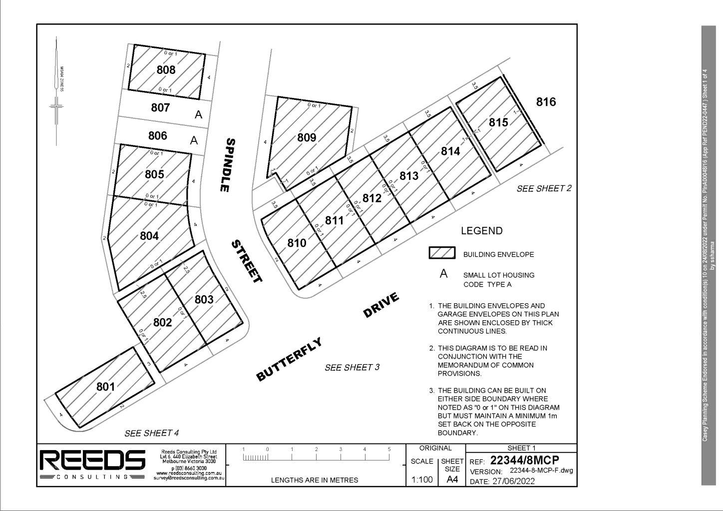
Memorandum of common provisions
This is page 6 of the Memorandum of Common Provisions 35271702A 91ATLA Page 6 of 9 THE BACK OF THIS FORM MUST NOT BE USED Land Use Victoria, contact details: see www.delwp.vic.gov.au/property>Contact us
Section 91A Transfer of Land Act 1958
Privacy Collection Statement
This is page 7 of the Memorandum of Common Provisions 35271702A 91ATLA Page 7 of 9 THE BACK OF THIS FORM MUST NOT BE USED Land Use Victoria, contact details: see www.delwp.vic.gov.au/property>Contact us
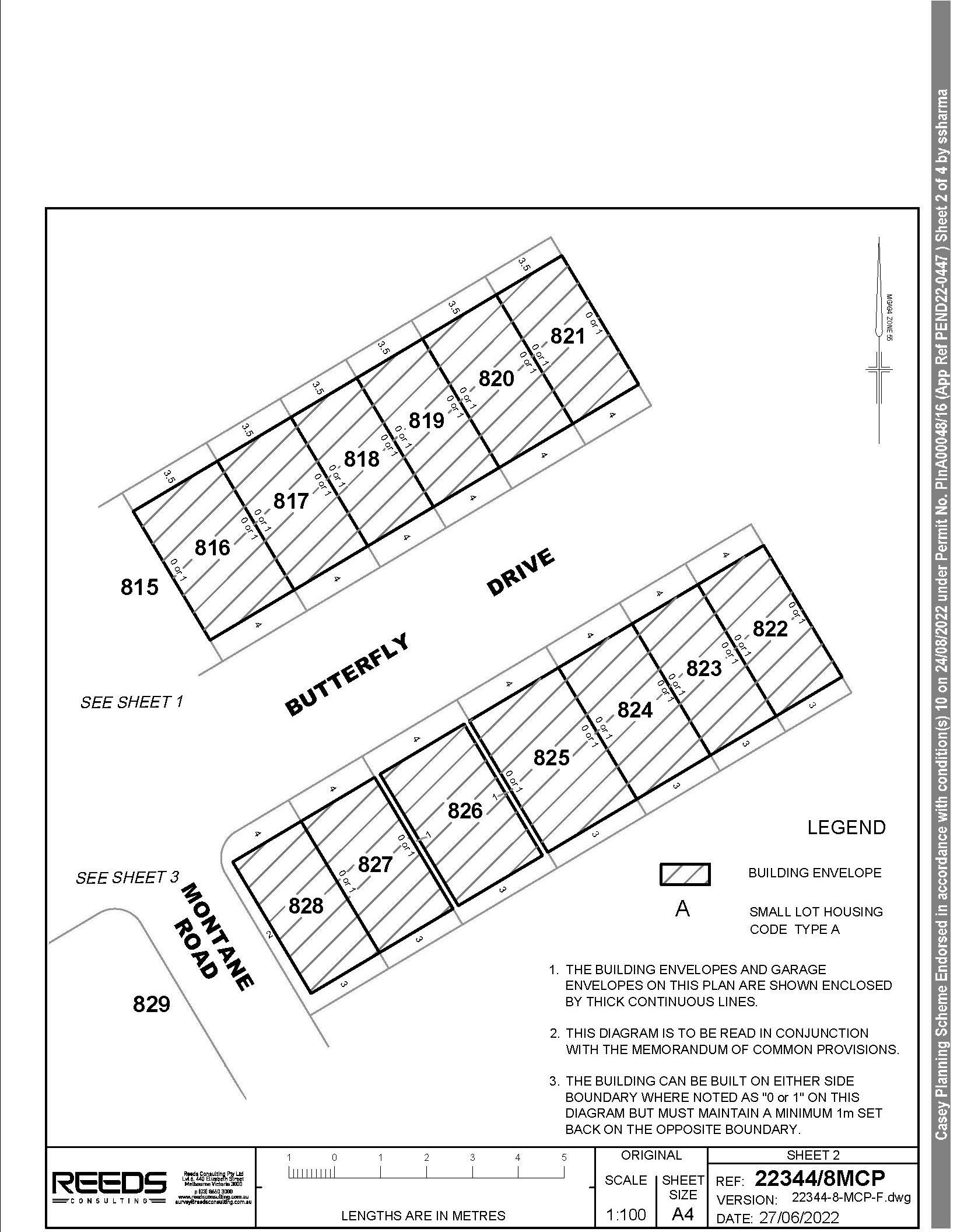
The information from this form is collected under statutory authority and is used for the purpose of maintaining publicly searchable registers and indexes.
Memorandum of common provisions
The information from this form is collected under statutory authority and is used for the purpose of maintaining publicly searchable registers and indexes.
Memorandum of common provisions
Section 91A Transfer of Land Act 1958
This is page 8 of the Memorandum of Common Provisions 35271702A 91ATLA Page 8 of 9 THE BACK OF THIS FORM MUST NOT BE USED Land Use Victoria, contact details: see www.delwp.vic.gov.au/property>Contact us
Privacy Collection Statement
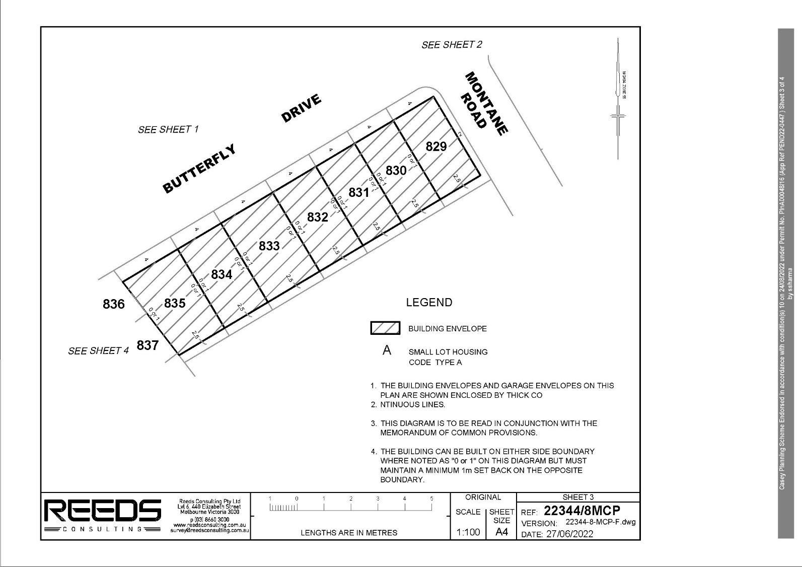
This is page 9 of the Memorandum of Common Provisions 35271702A 91ATLA Page 9 of 9 THE BACK OF THIS FORM MUST NOT BE USED Land Use Victoria, contact details: see www.delwp.vic.gov.au/property>Contact us
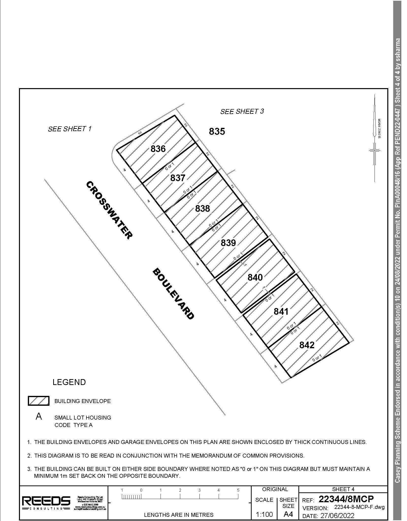
Memorandum of common provisions
Section 91A Transfer of Land Act 1958
The information from this form is collected under statutory authority and is used for the purpose of maintaining publicly searchable registers and indexes.
Privacy Collection Statement
Where the subdivision is to be developed in stages, the time specified for the commencement of the first stage is four (4) years from the date of this permit. The time specified for the commencement of any subsequent stage is ten years from the date of this permit and the time specified for the completion of each stage is five years from the date of its commencement.
N.B. the starting of the subdivision is regarded by Section 68(3A) of the Planning and Environment Act 1987 as the certification of the plan under Section 6 of the Subdivision Act 1988. Completion is regarded as registration of the subdivision.
Permit No.: PlnA00048/16
A copy of the permit is enclosed for your attention.
Permit Allows: Multi-Lot Subdivision in stages (up to 1000 lots), Construction and Carry Out Works Including Roadworks within an Urban Floodway Zone and Land Subject to Inundation Overlay, Creation of Restrictions and Creation of Access to a Road in a Road Zone Category 1
If you have any questions about this matter, please contact the undersigned on 9705 5831.
(a) started within four (4) years of the date of this permit, or, (b) completed within five years from the date of starting.
Address: 1275 Pound Road CLYDE NORTH VIC 3978 Lot 1 TP 392956D

Frontlink Pty Ltd C/- Reeds Consulting Pty Ltd GPO Box MELBOURNE2240VIC 3001
I refer to your application for an extension of time received on 14 January 2020.
Pursuant to Section 69(2) of the Planning and Environment Act 1987, the Responsible Authority extends the time for the starting of the permitted subdivision by one (1) year, and, the permitted subdivision must now be:
On 12 March 2020, Council’s delegate approved the application.
12 March 2020
Dear Sir/Madam
PlnA00048/16 - 2 - 12 March 2020
Michael Ford Principal Planner Growth and Investment Enc:
Yours faithfully

Dear Sir/Madam Permit Proposal:Address:No.: 1275PlnA00048/16PoundRoad
I also wish to draw your attention to the time limit imposed on the permit. It is the responsibility of the person acting on the permit to seek an extension of time prior to the expiry of this permit.
Cc: Melbourne Water, VicRoads, South East Water, APT Group (Gas), AusNet Electricity Services Pty Ltd, Public Transport Victoria, APA GasNet, APA VTS Australia (Operations).
Cl-

You ithfullyorSubdivision Permits Enc. Contact City of Casey 03 9705 5200 NRS: 133 677 (for the deaf, hearing or speech impaired) TIS: 131 450 (Translating and Interpreting Service) Customer Service Centres Cranbourne— Cranbourne Park Shopping Centre Narre Warren — Civic Centre, Magid Drive Narre Warren South — Amberly Park Shopping CentreNarrecaseycc@casey.vic.gov.auPOBox1000WarrenVIC3805 City of CaseyABN: ABN 43 320 295 742 Ausdoc: DX 30460 Berwick
MELBOURNE2240 VIC
• Construction and Carry Out Works Including Roadworks within an Urban Floodway Zone and Land Subject to Inundation Overlay;
Sebastian Lorenzo/sf April 2017
I wish to advise you that your application for the above planning permit was approved by Council on 27 April 2017. Please find enclosed your copy of the Planning Permit.
• Creation of Restrictions; and,
• Creation of Access to a Road in a Road Zone Category 1.
GPO
• Multi-Lot Subdivision in stages (up to 1000 lots)
The granting of this permit does not absolve the person to whom it is granted or any other person from complying with any other Local Law Statute or Regulations.
It is your responsibility to ensure all other relevant permits including Building Septic Health and Local Laws are obtained if required prior to the commencement of any use and/or development.
Frasers Property Australia (Residential) Reeds Consulting Pty Ltd Box 3001
CLYDE NORTH VIC 3978 Lot 1 TP 392956D
28
o That sufficient land is set aside on the southern side of the Honour Avenue in Stage 1 to accommodate the roundabout with Riverstone Boulevard.
1275 Pound Road CLYDE NORTH VIC 3978 Lot 1 TP 392956D
THE PERMIT ALLOWS:
Responsible authority City of Casey
Amended Subdivision Master Plan
(f) A cross-section of that section of Honour Avenue which is widened to 37 metres illustrating the proposed lot boundaries, road pavement, nature strip, indented parking, paths etc.
Page
(d) A notation on the plans that lots to the north of the intersection of Roads 1, 2 and 3 will not have vehicle access from any future roundabout. This may require the reconfiguration of relevant lots.
• Multi-Lot Subdivision in stages (up to 1000 lots)
o That sufficient land set aside on the southern side of the Honour Avenue in the relevant stage to accommodate the roundabout with Como Parade.
(c) The following changes illustrated on the subdivision master plan with the changes supported via a separate plan or document (i.e. FLP / swept path analysis or similar):
Date issued: 27 April 2017 Signature for the 1 of 29 responsible authority
1. Prior to the commencement of works and / or the certification of the first plan of subdivision, an amended Estate Development Plan to the satisfaction of the Responsible Authority must be submitted to and approved by the Responsible Authority. When approved, the plans will be endorsed and will then form part of the permit. The plans must be drawn to scale with dimensions and three copies must be provided (hard copies at an Al scale). The plans must be generally in accordance with the plan prepared by Reeds Consulting 'Estate Development Plan', (Ref No. 23344P Version H dated 12 October, 2016) but modified to show:
Permit No. P1nA00048/16
Planning scheme Casey Planning Scheme
• Construction and Carry Out Works Including Roadworks within an Urban Floodway Zone and Land Subject to Inundation Overlay;
Conditions: 1-100 and notes (Inclusive)

PLANNING PERMIT
(a) All lots numbered.
• Creation of Restrictions; and,
• Creation of Access to a Road in a Road Zone Category 1.
THE FOLLOWING CONDITIONS APPLY TO THIS PERMIT:
(e) A notation on the plans that lots to the north and south of the intersection of Roads 20 and 22 will not have vehicle access from any future roundabout. This may require the reconfiguration of relevant lots.
ADDRESS OF THE LAND:
(b) A Stage Sequencing Table included on the plan.
(m) A notation specifying that a 3.0 metre wide concrete shared path will be provided along the Thompsons Road frontage of the site at the full cost of the developer to be constructed at the time of the relevant abutting stage.
Date issued: 27 April 2017 Signature for the responsible authority
(p) Dimensions of the land set aside in the relevant stage which is being added to the existing Soldiers Road reserve to form the Connector Street on the site's eastern boundary. The overall road reservation is to be identified as having a minimum road reserve width of 31 metres in accordance with the Clyde North PSP Plan 16 — Road Network and Plan 18 — Walking & Trails Plan.
Casey Planning Scheme
Page 2 of 29

(n) The following included within a specific stage of the subdivision:
Planning scheme
(i) That section of Soldiers Road which is to be close adjoining the government school site nominated as also forming part of the future government school with the area and dimensions of this parcel clearly nominated.
(j) The indicative alignment of 2.5 metre wide shared paths through open space reserves as identified in Plan 18 of the Clyde North Precinct Structure Plan.
Responsible authority City of Casey
(i) Unencumbered Active Open Space 'E'.
(ii) The tree reserve from the new alignment of Soldiers Road to the eastern corner of the subject land.
(iii) Road widening / intersection flaring in the south-eastern corner of the site along Thompsons Road.
PERMIT
PLANNING
(h) A notation stating that any land required to be set aside for intersection flaring and the ultimate Thompsons Road reservation will be in accordance with the requirements of the Responsible Authority and VicRoads.
(q) The width of each extended driveway / driveway link and a notation added to state that car parking will be provided within that space at a rate of one per lot accessed from the driveway link.
Permit No. PlnA00048/16
(r) All proposed substation / kiosk sites clearly identified with a contrasting colour.
(s) The roundabout at the intersection of Road 38, Soldiers Road Extension and Road 41 removed.
(o) Dimensions of all municipal reserves (including tree reserves) with any tree reserve to Thompsons Road having a minimum width of 12.0 metres.
(t) The location of Road 38 moved further north and designed and located as a left in / left out in accordance with Plan 16 — Road Network of the Clyde North PSP with a notation stating that right turn movements are subject to VicRoads approval.
(u) Road 41 designed and located as a left in / left out in accordance with Plan 16 — Road
(k) Identification of a 2.5 metre wide off-road shared path along all proposed Connector Streets and Access Streets Level 2 as shown in Plan 18 of the Clyde North Precinct Structure Plan.
(I) The indicative location of bus stops as specified in Plan 17 of the Clyde North Precinct Structure Plan.
(g) The location of the median strip and direction of traffic flow for those lots within Stage 1 which are to be accessed from the service road.
Casey Planning Scheme
(h) Any other relevant matter related to the provision of infrastructure reasonably required by the responsible authority including:
Date issued: 27 April 2017
Public Infrastructure Plan
(ii) The southern section of the existing Soldiers Road reservation (abutting Superlot C — school site) will not be closed until an alternative access to Thompsons Road and to Soldiers Road to the north is in place to the satisfaction of the Responsible Authority.
(g) Include the following notation:
(c) The provision, staging and timing of road works (including intersections) internal and external to the land consistent with any relevant traffic report or assessment.
PERMIT
Signature for the responsible authority
Permit No. PlnA00048/16
(i) The northern section of the existing Soldiers Road reservation (abutting Superlot B) will not be closed until the new alignment of Soldiers Road has been constructed and a working connection is available to the north and to Thompsons Road to the satisfaction of the Responsible Authority.
(f) What (if any) infrastructure set out in the Development Contributions Plan applying to the land is sought to be provided as "works in lieu" subject to the consent of Casey City Council.
(d) The provision of public open space and tree reserves.
(v) Each of the encumbered open space areas which serve as drainage function nominated as "Encumbered Open Space (Melbourne Water Drainage Reserve)".
2. Prior to the commencement of works and / or the certification of the first plan of subdivision, a Public Infrastructure Plan to the satisfaction of the Responsible Authority must be submitted to and approved by the Responsible Authority. The Public Infrastructure Plan must address the
(e) The landscaping of any land.
Network of the Clyde North PSP with a notation stating that right turn movements are subject to VicRoads approval.
Planning scheme
Page 3 of 29

(a)following:What
(i) The permit applicant acknowledges to Council that the approval of the Permit PIP by Council is being done by Council in its capacity as the Responsible Authority and does not provide any indication or advice as to whether Council, acting in its capacity as the Collecting Agency under the relevant Development Contributions Plan, will approve a proposal to carry out any DCP projects as works in kind. The permit applicant acknowledges that a separate and formal request to carry out a DCP project as a works in kind project is required.
•(b) The provision, staging and timing of stormwater drainage works, including any temporary drainage works approved by Melbourne Water and the Responsible Authority.
Responsible authority City of Casey
PLANNING
land may be affected or required for the provision of public infrastructure works and the timing of when such land will be provided.
Planning scheme
(f) The location of fencing including tree, walkway and vehicle exclusion fencing.
Open Space Landscape Master Plan
(iv) Intersection RD10 (as referenced in the Clyde North Development Contributions Plan) and the left-in left-out intersection to the south of Intersection RD10 on the future Soldiers Road alignment, specifying that any land to accommodate these intersections and the construction of those intersections will occur as part of the development of Superlots A and/or B which will be the subject of a separate application or when Soldiers Road extension (Arterial Road) is constructed, with the timing to be determined in consultation with the responsible authority.
(d) The general layout of street tree plantings including the proposed tree species,
(e) The indicative location of paths and trails as per the PSP and approved subdivision master plan.
PLANNING
PERMIT
(b) Buildings and trees (including botanical names) on neighbouring properties where impacted on by the proposed subdivision.
Date issued: 27 April 2017

(h) Consistency of streetscape planting where streets continue from adjoining developments into the subject site. Note: It is the developer's responsibility to liaise with adjoining developer(s) to ensure planting consistency.
(a) Vegetation that is approved to be retained.
(c) The proposed road reserve widths including proposed areas within the road reserves set aside for the retention of existing vegetation.
Responsible authority City of Casey
3. Before the certification of the first plan of subdivision, a Street Tree Master Plan for the whole of the estate prepared by a person suitably qualified or experienced in landscape design to the satisfaction of the Responsible Authority must be submitted to and approved by the Responsible Authority. When approved, the plan will be endorsed and will then form part of the permit. The plan must be drawn to scale with dimensions and three copies must be provided. The Street Tree Master Plan must show:
Street Tree Master Plan
Casey Planning Scheme
(iii) The construction of a roundabout at the intersection of Como Parade, Honour Avenue and the future Connector Street into Superlot A, specifying that land required to accommodate the roundabout and the construction of that roundabout will occur upon the future development of Superlot A, or with the relevant abutting stage to the satisfaction of the responsible authority.
(g) Indicative road reserve cross-sections with street tree planting illustrated.
4. Before the certification of the plan of subdivision for a stage which creates an open space reserve, an open space landscape master plan for the respective reserve prepared by a person suitably qualified or experienced in landscape design to the satisfaction of the Responsible Authority must be submitted to and approved by the Responsible Authority. When approved, the plan will be endorsed and will then form part of the permit. The plan
All species selected must be to the satisfaction of the Responsible Authority.
Permit No. PlnA00048/16
Signature for the Page 4 of 29 responsible authority
(d) The area and dimensions of the open space reserve.
Casey Planning Scheme
(a) Vegetation that is approved to be retained, removed and/or lopped.
PLANNING PERMIT
Planning scheme
must be drawn to scale with dimensions and three copies must be provided. The Open Space Landscape Master Plan must show:
Permit No. PlnA00048/16
(c) Site contours and any proposed changes to existing levels including any structural elements such as retaining walls.
(h) The proposed location of playgrounds including a list of proposed play elements and age groups of play.
8. The plan of subdivision submitted for certification must identify whether Type A or Type B of the Small Lot Housing Code applies to each lot to the satisfaction of the responsible authority.
(g) The proposed location of paths, trails and any other pavement areas.
All species selected must be to the satisfaction of the Responsible Authority.
Section 173 Agreement

Date issued: 27 April 2017 Signature for the Page 5 of 29 responsible authority ....
5. The subdivision master plan and any other documentation endorsed to form part of the permit must not be altered or modified without the prior written consent of the Responsible Authority.
(i) The location of fencing including tree, walkway, vehicle exclusion and open space reserve fencing.
6. The subdivision must proceed in the order of stages shown on the endorsed plans unless otherwise agreed in writing by the Responsible Authority.
Miscellaneous
7. Prior to the certification of the plan of subdivision for the relevant stage, a plan must be submitted for approval to the satisfaction of the responsible authority. The plan must identify the lots that will include a restriction on title allowing the use of the provisions of the Small Lot Housing Code incorporated pursuant to Clause 81 of the Casey Planning Scheme.
9. Before the first Plan of Subdivision is certified under the Subdivision Act 1988, or at such other time which is agreed in writing by Council and the Development Agency under the relevant Contributions Plan, the owner must enter into an agreement or agreements under Section 173 of the Planning and Environment Act 1987 (Act) with the responsible authority which provides for:
Small Lot Housing Code
Responsible authority City of Casey
(b) Buildings and trees (including botanical names) on neighbouring properties within three metres of the boundary.
(e) The general layout of reserve plantings including the proposed location of evergreen and deciduous tree species, and an indicative species list of all proposed planting
(f) The proposed location of structures and furniture items.
Permit No. PlnA00048/16
The owner/applicant must pay the Responsible Authority's reasonable costs for the preparation, execution and registration of the Section 173 Agreement.
Casey Planning Scheme
(i) for lots of between 250 and 300 square metres opposite or abutting a passive or active open space area or local town centre / activity centre where the front setback can be reduced to 3 metres.
Actions Prior to Works and/or Certification
(d) If applicable, the prohibition of the sale of lots or vesting of reserves created prior to their embellishment/servicing having regard to the approved Public Infrastructure Plan until such time as they are embellished/serviced with respect to the applicable conditions of the Permit and a Statement of Compliance has been issued for the relevant stage in which they will be embellished/serviced, unless with the written consent of the Responsible Authority.
PLANNING
Where such lots/reserve are created and if relevant, the production of a certificate issued by the State Revenue Office stating that there will be no Growth Areas Infrastructure Contribution liability in respect of any land to be vested in Council or alternatively evidence of payment of that Contribution to the satisfaction of the Responsible Authority prior to the issue of a Statement of Compliance for the relevant stage in which the land will be embellished/serviced in accordance with the approved Public Infrastructure Plan.
Date issued: 27 April 2017 Signature for the responsible authority
(a) At least a 4 metre front setback to all lots, except:
Page 6 of 29

PERMIT Planning scheme
(a) The implementation of the Public Infrastructure Plan approved under this permit;
(b) The transfer to or vesting in Council of any land required for road widening or public open space or any other infrastructure project funded under the relevant Development Contributions Plan at a time which is agreed with Council and the Development Agency under the relevant Development Contributions Plan;
(c) The equalisation of public open space contributions having regard to the amount specified in the schedule to Clause 52.01 of the Casey Planning Scheme (3.54%) and the Property Specific Land Budget contained within the relevant Precinct Structure Plan.
(e) The timing of any credit or payments to be made to a person in respect of any infrastructure project having regard to the availability of funds in the Clyde Development Contributions Plan.
(ii) for lots over 300 square metres which adjoin a bank / row of Small Lot Housing Code lots whereby a reduced setback may be considered to the Satisfaction of the Responsible Authority.
Responsible authority City of Casey
10. Prior to the certification of any plan of subdivision (or a relevant stage of a subdivision), building envelopes in accordance with Part 4 of the Building Regulations must be submitted to the Responsible Authority for approval for lots of between 250 square metres and 500 square metres where the Small Lot Housing Code is not applied, all to the satisfaction of the Responsible Authority. Once approved the plans will be endorsed and form part of the Permit. The building envelopes must be designed to consider the provision of solar access and any other requirements provided on the plans endorsed to the Permit as relevant, and must show:
Date issued: 27 April 2017

(c) At least a 2 metre offset from any boundary abutting a side street.
Casey Planning Scheme
Permit No. PlnA00048/16
• South East Water;
11. Prior to the certification of any plan of subdivision (or a relevant stage of a subdivision), any restrictions on the plan of subdivision including relevant "Design Guidelines" and / or Memorandum of Common Provisions must be submitted to the Responsible Authority for approval and applied to all lots to the satisfaction of the Responsible Authority. Once approved, the restrictions and associated documentation will be endorsed and form part of the permit. The restrictions / Design Guidelines / Memorandum of Common Provisions must include:(a)Arestriction that does not allow garage openings to occupy more than 40% of the width of the primary frontage, unless the building is two or more storeys and on a lot with an area between 250 to 300 square metres whereby the garage opening must not exceed 30% of the area of the front façade of the dwelling with the area of the front façade measured from a two dimensional elevation plan of the façade excluding the area of the roof of the dwelling
• APA Group (APT O&M Services Pty Ltd);
(c) Differentiation of fencing restrictions for corner lots as opposed to standard lots in relation to fencing of a side boundary, acknowledging that corner lots should address both the primary and secondary street frontage.
PERMIT Planning scheme
Responsible authority City of Casey
(b) A restriction that does not allow garages or carports to be setback less than 5.5 metres from the primary frontage, unless a building envelope within an associated plan of subdivision allows a primary frontage setback of 3 metres, whereby the garage or carports shall not be setback less than 5 metres from the primary frontage; or, in special circumstances where lots are identified on the building envelope within an associated plan of subdivision as having an alternative garage setback whereby garages on those lots must not be setback between 3 and 5 metres from the primary frontage.
(d) A consent mechanism with respect to building outside of a building envelope with the written consent of the Responsible Authority.
13. Prior to certification of any plan of subdivision, the plan must be referred to the following authorities under Section 8 of the Subdivision Act:
• Melbourne Water;
12. Before any plan of subdivision is certified under the Subdivision Act 1988, for each stage of the subdivision, a schedule of lots created and housing densities, must be submitted to Council showing the number of lots created in the stage together with cumulative totals of any lots created and housing densities in earlier stages of the subdivision, to the satisfaction of the Responsible Authority.
• Country Fire Authority;
PLANNING
Signature for the Page 7 of 29 responsible authority
(d) A Build to Boundary Zone must only apply to one side boundary. This can be shown on both side boundaries with a notation stipulating that only one of these zones can be utilised per lot in relation to the location of the crossover provided to that lot.
(b) At least a 1 metre offset from any boundary abutting a reserve.
(e) Any tree reserves to be vested with the City of Casey.
PERMIT Planning scheme
(b) Building envelopes and the creation of restrictions to accord with those identified on plans/documents endorsed to the Permit.
Casey Planning Scheme
• VicRoads; and
Permit No. PlnA00048/16
(f) All bearings, distances, street names, lot numbers, lot sizes, reserves and easements.
PLANNING
14. The plans submitted for certification must be in accordance with the endorsed plans but modified to show to the satisfaction of the Responsible Authority and relevant servicing
(c) Unless otherwise agreed in writing by the Responsible Authority, road reserve and court head dimensions in accordance with the Growth Area Authorities standard drawings.
15. Prior to the commencement of works: a Salvage Plan for threatened species including Southern Toadlet, Glossy Grass Skink and Growling Grass Frog must be prepared to the satisfaction of the Secretary to the Department of Sustainability and Environment and the approval of the responsible authority.
Clyde North Native Vegetation Precinct Plan (NVPP)
Certification Plans
• Ausnet Services;
(d) Any land required to be set aside for the purpose for road widening and to be vested in Council in accordance any relevant condition of this permit. .
17. Prior to the removal, destruction or lopping of any native vegetation within any property (based on the property number in Map 1 of the NVPP), offsets must be provided, and a legal agreement entered into, in relation to all of the native vegetation within that property which this Native Vegetation Precinct Plan allows to be removed, destroyed or lopped, to the satisfaction of the Secretary to the Department of Sustainability and Environment. In determining the offset to be required in relation to any property , the Secretary to the Department of Sustainability and Environment will seek to give effect to Victoria's Native Vegetation Management: A Framework for Action and will be guided by the offsets identified in Table 5 and Table 6, in relation to the relevant vegetation authorised to be removed.
required by servicing authorities as well as any easements required by the responsible authority over any temporary drainage assets which are to be managed by the responsible authority.
Date issued: 27 April 2017 Signature for the responsible authority
Page 8 of 29

16. The approved Salvage Plan must be implemented to the satisfaction of the Secretary to the Department of Sustainability and Environment and the responsible authority.
18. Prior to commencement of any works including vegetation removal a highly visible vegetation protection fence must be erected around twice the canopy distance of each
(a)authorities:Alleasements
Salvage Plan
Responsible authority City of Casey
• Public Transport Victoria (only where the stage being created contains a bus route, in accordance with condition 59 (b)).
19. Any construction stockpiles, fill and machinery must be placed away from areas supporting native vegetation and drainage lines to the satisfaction of the responsible authority.
Signature for the responsible authority
23. Water run-off must be designed to ensure that native vegetation to be protected is not compromised.
Page 9 of 29

Permit No. PlnA00048/16
scattered tree and more than 2 metres from areas of all other native vegetation which have been identified to be protected unless otherwise agreed to in writing by the Secretary to the Department of Sustainability and environment and to the satisfaction of the responsible authority.
20. Prior to felling any tree which may be removed, the tree must be examined by a suitably qualified zoologist for the presence of fauna in hollows or external nests. If native fauna species are located, they must be salvaged and relocated to the closest suitable vegetation, in consultation with the Department of Sustainability and Environment.
Prior to the Commencement of Works
(a) Functional layout plans for the interim and ultimate intersection of any internal road and existing or future arterial roads as approved by VicRoads and the Responsible Authority, along with detailed design of the interim intersections;
24. Any native vegetation to be removed (in accordance with this NVPP) must be clearly marked on site to the satisfaction of the Responsible Authority whilst works are being undertaken in the vicinity.
Responsible authority City of Casey
26. Before any road/drainage works associated with each stage of the subdivision start, detailed construction plans to the satisfaction of the Responsible Authority must be submitted to and approved by the Responsible Authority. The plans must be drawn to scale with dimensions and three copies must be provided. The plans must include, as relevant:
25. If Thompsons Road is to be used by construction traffic, before construction associated with the approved subdivision commences on site, Thompsons Road must be constructed to a standard sufficient to accommodate construction vehicles from Berwick-Cranbourne Road through to construction access to the subject site, to the satisfaction of the Responsible Authority and VicRoads.
(c) Fully sealed pavements with kerb and channel (or rollover kerbs where appropriate) to dimensions generally in accordance with the relevant road cross-sections in the Precinct Structure Plan applying to the land;
22. Only indigenous plants of local provenance may be used in revegetation works of conservation areas.
(b) Detailed design of any roadworks being undertaken by the development proponent external to the site to the satisfaction of VicRoads and the Responsible Authority.
(d) Traffic management devices;
Date issued: 27 April 2017
Casey Planning Scheme
21. All earthworks must be undertaken in a manner that will minimise soil erosion and adhere to Construction Techniques for Sediment Pollution Control, EPA 1991.
PLANNING PERMIT Planning scheme
(iii) offset a minimum of 6 metres from the tangent point of any side streets (refer to Australian Standards, Parking Facilities, Part 1: Off-street car parking).
(I) Temporary turnaround areas within the site for waste collection vehicles (8.8 metres in length) at the dead end of any road;
(m) Drainage systems, including:
(i) All aspects of the stormwater drainage system including drainage reserves and retarding basins, wetlands, stormwater connections and ouffalls and any Water Sensitive Urban Design Measures (if relevant);
(i) Both sides of the Soldiers Road identified as RD-04 in the Clyde North DCP.
Permit No. PlnA00048/16
(I) located on the long side of corner sites where roundabout splitter islands will hinder access.
Date issued: 27 April 2017 Signature for the responsible authority
(ii) The north side of Thompsons Road.
(ii) features to prevent litter, sediment and oils from entering the drainage system and/or cut-off drains to intercept stormwater run-off from adjoining properties. Such features may be suitably sized litter traps for surface rubbish, oil and sediment. These devices must be constructed within the works upstream of the outfall drain for the subdivision; and
(e) Vehicle exclusion fencing where necessary;
(f) Where a construction plan contains a road identified as a bus route within the Precinct Structure Plan applying to the land, the cross section of the road must comply with the Precinct Structure Plan and be to the satisfaction of Public Transport Victoria;
(i) Concrete footpaths and/or shared paths in accordance with the relevant Precinct Structure Plan on both sides of each roadway with the exception of the side of a road that abuts a public open space;
(iii) Along the drainage reserves between the north-west (Honour Avenue) corner of the site and east (existing Soldiers Road) boundary of the site to the satisfaction of the Responsible Authority.
Casey Planning Scheme
(iv) as well as where identified in the Clyde North PSP and on the endorsed plans.
(ii) located a minimum of 1 metre from any service facilities.
PLANNING PERMIT Planning scheme
(j) Shared paths along:
Page 10 of 29

(g) Corner splays, as required, to suit the road function;
Responsible authority City of Casey
(h) Driveway links designed to provide one (1) visitor space per lot served by the link;
(k) A vehicular crossing to each lot, except those nominated as a medium density lot or superlot on the endorsed plan, designed in accordance with the Growth Areas Authority Standard Drawings unless otherwise agreed. Unless an alternative treatment is approved by the Responsible Authority, crossovers on lots with frontages of 10 metres or less must abut a crossover on an abutting lot to create a combined crossover of no more than 3 metres in width (excluding splays) at the kerb. Crossovers should be:
(b) The drainage system must protect the subdivision from any rural storm water flows draining towards the site from upstream catchments.
(c) The drainage system must prevent stormwater from overflowing in an uncontrolled manner from the site onto adjacent properties.
(r) Services located in shared trenches wherever possible, (s) Fibre optic conduit network throughout the subdivision; and
(u) All shared paths / on-road bike paths as required by the Clyde North PSP and as illustrated on the endorsed subdivision master plan.
(n) Permanent survey marks, levelled to the Australian Height Datum and coordinated to the Australian Map Grid;
Permit No. PlnA00048/16
PLANNING
The engineering construction plans must include, at the relevant stage as identified on the Public Infrastructure Plan approved under this Permit, any lot or reserve previously created from the parent title that has yet to be embellished/serviced in accordance with the requirements of this Permit.
(a) The drainage system for the subdivision must cater for any and all external catchments that are draining towards the subdivision from any upstream catchments.
(q) Details of any cut and fill;

Responsible authority City of Casey
Casey Planning Scheme
Planning scheme
(o) The location of street lighting;
27. Before the development starts, drainage construction plans to the satisfaction of the Responsible Authority must be submitted to and approved by the Responsible Authority. The plans must be drawn to scale with dimensions and three copies must be provided. The plans must address the following matters:
28. No less than 14 days before the works commence a site specific Environmental Management
Date issued: 27 April 2017 Signature for the Page 11 of 29 responsible authority
(d) The stormwater discharge from this site must not exceed the allowable discharge. If the stormwater from this development exceeds the allowable capacity of the outlet drainage, then a stormwater retarding system will be required. Please contact City of Casey Engineering Department for further information.
PERMIT
(t) All concrete and construction materials used on site must comply with AS 2159-2009 and AS 3600-2009.
(iii) measures to satisfy the objectives of "Best Practice Environmental Management Guidelines" (CSIRO 1999) to reduce or retain in total 80% of suspended solids, 45% phosphorus, 45% nitrogen; and 70% litter/ gross pollutants larger than 5mm" and meet the intended outcomes of Clause 56 of the planning scheme to the satisfaction of the responsible authority; and,
(iv) construction details of any temporary drainage works approved by Melbourne Water and the Responsible Authority, along with details of any safety measures, edge treatments and separation distances between those works and the land being subdivided;
(p) Any water sensitive urban design features;
In preparation of the Site EMP, the applicant must use the environmental protection measures as set out in EPA's publication 480 "Environmental Management Guidelines for Major Construction Sites" unless it can be demonstrated that alternative techniques can fulfill the specified site requirements.
(a) Existing vegetation that is approved to be retained.
Casey Planning Scheme
Date issued: 27 April 2017 Signature for the responsible authority
Note that A-Spec digital documentation for open space assets must be provided at Practical Completion stage of landscape construction in a format consistent with Condition No.61 .
31. The Clyde North PSP Cardinia Creek: Threatened Fauna Conservation Management Plan, approved by the Department of Sustainability and Environment and endorsed by the Responsible Authority must be implemented to the satisfaction of the Secretary to the
All species selected must be to the satisfaction of the Responsible Authority.
Page 12 of 29

PLANNING
Conservation Management Plan
(f) Additional supporting information, such as certified structural designs or building forms
PERMIT
Permit No. PlnA00048/16
Planning scheme
Plan (Site EMP) must be submitted to and approved by the Responsible Authority. The Site EMP must be prepared in accordance with Council's 'Site EMP Kit' to the satisfaction of the Responsible Authority. No alterations to the Site EMP may occur without the consent of the Responsible Authority. All works must be undertaken in accordance with the approved Site EMP to the satisfaction of the Responsible Authority.
(b) New plantings including their layout to be provided in all road, open space, plantation and municipal reserves.
30. The developer must notify the Responsible Authority a minimum of 7 days prior to commencing street tree planting and landscaping so that surveillance of the works can be undertaken.
Responsible authority City of Casey
29. Before the start of any landscaping works for any stage of the subdivision, a detailed landscape plan and plant schedule for that stage prepared by a person suitably qualified or experienced in landscape design to the satisfaction of the Responsible Authority must be submitted to and approved by the Responsible Authority. The plan must show the proposed landscape and plant schedule for all public open space areas, including streetscapes, parkland water retention areas, buffer zones, service corridors and community uses. When approved, the plan will be endorsed and will then form part of the permit. The plan must be drawn to scale with dimensions and three copies must be provided. The landscaping plan must be generally in accordance with the landscape master plan approved under the relevant condition of this permit except that the plan must show:
(c) A detailed plant schedule including all proposed tree, shrub, groundcover and climbing plant species.
(d) The proposed location and final set out of paths, areas of pavement, playgrounds, play items, structures and street furniture.
(e) Detailed planting and construction drawings including site contours and any proposed changes to existing levels including any structural elements such as retaining walls.
Responsible authority City of Casey
Page 13 of 29
37. Before the issue of a Statement of Compliance for any stage of the subdivision the developer must make payment to Council for the provision of Community Infrastructure, unless before the relevant plan of subdivision is certified under the Subdivision Act 1988, the owner enters into an agreement with the Responsible Authority made pursuant to Section 173 of the Planning and Environment Act 1987 ('the Act') and made application to the Registrar of Titles to have the agreement registered on the title to the land under Section 181 of the Act, which provides for the payment of a Community Infrastructure Levy to Council by a future land owner in accordance with the provisions of the Development Contributions Plan applying to the land and Section 460 of the Act.
Development Contributions
36. Where the subdivision is to be developed in stages the infrastructure levy for the stage to be developed only may be paid to Casey City Council within 21 days prior to the issue of a Statement of Compliance in respect of that stage, provided that a Schedule of Development Contributions is submitted with each stage of the plan of subdivision. This Schedule must show the amount of development contributions payable for each stage and value of the contributions in respect of prior stages to the satisfaction of Casey City Council.
PERMIT Planning scheme
Permit No. PlnA00048/16
The owner/applicant must pay the Responsible Authority's costs of the preparation, execution and registration of the Section 173 agreement.
34. Before the issue of a Statement of Compliance for the plan of subdivision under the Subdivision Act 1988, the developer must pay Council an amount equivalent to 2.5% of the estimated cost of the works which are subject to supervision in accordance with Section 17(2)(b) of the Subdivision Act 1988.
Department of Sustainability and Environment, Melbourne Water, and the Responsible Authority. Implementation requires that any specified actions relevant to the site must be carried out in accordance with the approved Conservation Management Plan.
PLANNING
32. Before the statement of compliance is issued under the Subdivision Act 1988 the applicant or owner must make a financial contribution to Melbourne Water in accordance with Section 5.2 Funding of the Clyde North PSP Cardinia Creek: Threatened Fauna Conservation Management Plan.
33. Before approval of the engineering plan/s submitted under Section 15(1) of the Subdivision Act 1988, the developer must pay Council an amount equivalent to 0.75% of the estimated cost of constructing the works proposed on the engineering plan.
35. A Development Infrastructure Levy, in accordance with the provisions of the Clyde North Development Contributions Plan must be paid by the applicant to the Collecting Agency after certification of the relevant plan of subdivision but not more than 21 days prior to the issue of a Statement of Compliance in respect of that plan under the Subdivision Act 1988.

Date issued: 27 April 2017 Signature for the responsible authority
Casey Planning Scheme
Community Infrastructure Levy
Engineering fees
Growth Areas Infrastructure Contribution
(d) Fibre optic conduits;
(i) The relevant intersections of the internal roads.
Casey Planning Scheme
(f) Temporary turnaround areas;
pay the GAIC liability in respect of that lot or reserve which is triggered upon the happening of the transaction; and

(b) Intersections and road construction projects are required by relevant conditions of this permit.
(c)or
(h) Lighting of roads and pedestrian/cycle paths designed and provided in accordance with Australian Standard 1158.1.
(e) Permanent survey marks, levelled to the Australian Height Datum and coordinated to the Australian Map Grid;
(a) Roads, including traffic management devices, kerb and channel, footpaths, shared foot/cycle paths and vehicular crossings to each lot;
(d) produce and provide to Council a Certificate of Release under section 201SY of the Act in respect of that lot or reserve.
38. Where the land is subdivided so as to create a lot or a reserve that is proposed or anticipated to be transferred to or vested in Council pursuant to the relevant Development Contributions Plan, the owner or developer of the land must, prior to the transfer to or vesting of that lot or reserve in Council (transaction):
(b) produce and provide to Council a Certificate of Release under section 201SY of the Planning and Environment Act 1987 (Act) in respect of that lot or reserve;
39. Before the issue of a Statement of Compliance for any stage of the subdivision under the Subdivision Act 1988, the developer must construct in accordance with the approved engineering construction plan/s and to the satisfaction of the Responsible Authority:
(c) Drainage and any water sensitive urban design features;
Date issued: 27 April 2017 Signature for the Page 14 of 29 responsible authority
Responsible authority City of Casey
PLANNING PERMIT Planning scheme
(g) Any tree protection fencing; and
(a) pay the Growth Areas Infrastructure Charge (GAIC) if a GAIC event could occur subsequent to the transfer to or vesting of the lot or reserve in Council provided that the development and the associated issue of a Building Permit which may give rise to the GAIC event is consistent with the manner in which that lot or reserve is anticipated to be developed under the relevant Development Contribution Plan or the relevant Precinct Structure Plan; and
Permit No. PlnA00048/16
Prior to Statement of Compliance
Responsible authority City of Casey
Date issued: 27 April 2017 Signature for the Page 15 of 29 responsible authority
42. Prior to the issue of a Statement of Compliance for the 866th Lot (or unless otherwise agreed to in writing by Council and VicRoads) of this approved subdivision, the road flaring required by RD-21 in the Clyde North DCP and the intersection IN-53-04 as identified in the Clyde DCP must be constructed in accordance with the relevant Development Contributions Plan to a standard which is to the satisfaction of the Responsible Authority and VicRoads.
Planning scheme Casey Planning Scheme
43. Prior to the issue of a Statement of Compliance for the 866th Lot (or unless otherwise agreed to in writing by Council and VicRoads) of this approved subdivision, the re-aligned Soldiers Road required by RD-01 (land) and RD-04 (construction) must be provided in its entirety from the northern property boundary of the site to the southern property boundary of the site with suitable connections provided to the existing Soldiers Road in the north and Thompsons Road in the south. The road must be constructed in accordance with the relevant Development Contributions Plan to a standard which is to the satisfaction of the Responsible Authority and VicRoads.
45. Prior to the issue of a Statement of Compliance for the relevant stage, fees must be paid to the Responsible Authority to cover the costs of ten (10) years of maintenance of the traffic signals associated with any signalised intersection, if these signals are to be delivered as part of the approved subdivision. The applicable fee is to be in line with VicRoads "Standard Requirements — Developer Funded Projects," to the satisfaction of the Responsible Authority.
47. Prior to the issue of a Statement of Compliance (or such later date as approved in writing by the Responsible Authority), all public open space areas, including, parklands, water retention areas, buffer zones, service corridors, community use areas and all streetscapes including road and plantation reserves must be landscaped and planted as shown on the approved landscape construction plans, (or bonded), to the satisfaction of the Responsible Authority.
44. Prior to the issue of a Statement of Compliance for the Plan of Subdivision that creates the full extent of the Connector Street (existing Soldiers Road reservation along the eastern boundary of the site), this 31 metre wide connector street must be constructed and full access provided to lots directly fronting that road to the satisfaction of the Responsible Authority.
46. The landscaping works shown on the approved plans for each stage must be carried out and completed or bonded to the satisfaction of the Responsible Authority, before the issue of a Statement of Compliance for each stage or by such later date as is approved by the Responsible Authority in writing.

48. Prior to the issue of a Statement of Compliance for any plan of subdivision under this permit that creates any public open space (where not otherwise provided for under the Clyde North
Permit No. PlnA00048/16
41. Prior to the issue of a Statement of Compliance for the 700th Lot (or unless otherwise agreed to in writing by Council and VicRoads) of this approved subdivision, the road flaring required by RD-20 in the Clyde North DCP and the intersection IN-53-03 as identified in the Clyde DCP must be constructed in accordance with the relevant Development Contributions Plan to a standard which is to the satisfaction of the Responsible Authority and VicRoads.
PLANNING PERMIT
40. Prior to the issue of a Statement of Compliance for Stage 1, suitable and sealed road access must be available to that stage through neighbouring subdivisions to the satisfaction of the Responsible Authority.
Responsible authority City of Casey
Casey Planning Scheme
50. All filling on the site over 300mm must be carried out, supervised, completed and recorded in accordance with AS 3798 - 2007 (Guidelines on earthworks for commercial and residential developments) to specifications to the satisfaction of the Responsible Authority. The geotechnical authority responsible for supervision and testing under this condition must be independently engaged by the applicant and not be engaged by the contractor carrying out the works. Before the issue of a Statement of Compliance unless otherwise agreed in writing by the Responsible Authority, compaction test results and a report shall be provided to the satisfaction of the Responsible Authority.
(b) Cleared of rubbish and environmental weeds, levelled, topsoiled and grassed with warm climate grass (unless a conservation reserve).
Mandatory Conditions for Subdivision Permits — Clause 66.01-1
(c) Provision of water tapping.
(f) Shared paths and / or footpaths as shown in the plans both endorsed and approved under this permit and the approved Precinct Structure Plan applying to the land.
Date issued: 27 April 2017 Signature for the Page 16 of 29 responsible authority

Permit No. PlnA00048/16
PLANNING PERMIT Planning scheme
(a) Removal of all existing disused structures, foundations, pipelines or stockpiles.
Public Open Space
(e) Vehicles exclusion devices (fence or other suitable method) with controlled access points.
49. Before the Statement of Compliance is issued under the Subdivision Act 1988 for any stage, a public open space contribution must be provided in accordance with the Schedule to Clause 52.01 of the Casey Planning Scheme in a manner consistent with the Clyde North Precinct Structure Plan.
Development Contributions Plan) the owner must re-grade, top dress, landscape and otherwise embellish the land to the satisfaction of the Responsible Authority including the following works:
Filling and works
(a) a telecommunications network or service provider for the provision of telecommunication services to each lot shown on the endorsed plan in accordance with the provider's requirements and relevant legislation at the time; and
(b) a suitably qualified person for the provision of fibre ready telecommunication facilities to each lot shown on the endorsed plan in accordance with any industry specifications or any standards set by the Australian Communications and Media Authority, unless the applicant can demonstrate that the land is in an area where the National Broadband Network will not be provided by optical fibre.
(d) Provision of planting and park furniture as identified on the approved landscape construction plans;
51. The owner of the land must enter into an agreement with:
(h) The subdivision is to make provision for overland flows from the upstream catchment utilising roads and / or reserves. Alignment of roads and reserves with any adjoining estates must ensure continuity and provide uninterrupted conveyance of overland flows.
(a) a telecommunications network or service provider that all lots are connected to or are ready for connection to telecommunications services in accordance with the provider's requirements and relevant legislation at the time; and
(b) Polluted and sediment laden runoff shall not be discharged directly or indirectly into Melbourne Water's drains or waterways.
(c) Prior to the certification of any stage of the development a drainage strategy must be submitted and approved by Melbourne Water, demonstrating the proposed alignment for the 1 in 5 year drainage infrastructure and overland flow paths directions for the 1 in 100 year ARI flood event. Details of the outlet connections (temporary and permanent), relevant calculations and treatment measures must be included. MUSIC models, design plans and approvals from the relevant authorities and downstream landowners must also be submitted. The development plan must be in accordance with the approved drainage strategy.
PLANNING PERMIT Planning scheme
Date issued: 27 April 2017 Signature for the responsible authority
Casey Planning Scheme
Referral Authority Conditions
Responsible authority City of Casey
(e) Engineering plans of the subdivision (in electronic format) are to be forwarded to Melbourne Water for comment / approval.
(g) A Certified Survey plan is to be submitted for approval after the completion of filling, verifying that the specific fill levels have been achieved. This will require prior to the issue of a Statement of Compliance for the subdivision.
Permit No. PlnA00048/16
52. Before the issue of a Statement of Compliance for any stage of the subdivision under the Subdivision Act 1988, the owner of the land must provide written confirmation from:
53. Melbourne Water conditions require that:
(f) All new lots are to be filled to a minimum of either 300nnm above the 1 in 100 year flood level associated with an existing or proposed Melbourne Water pipeline or 600nnm above the 1 in 100 year flood level associated with an existing or proposed Melbourne Water waterway, wetland or retarding basin whichever one is greater.
(b) a suitably qualified person that fibre ready telecommunication facilities have been provided in accordance with any industry specifications or any standards set by the Australian Communications and Media Authority, unless the applicant can demonstrate that the land is in an area where the National Broadband Network will not be provided by optical fibre.
(a) Prior to the issue of a Statement of Compliance, the Owner shall enter into and comply with an agreement with Melbourne Water Corporation for the acceptance of surface and storm water from the subject land directly or indirectly into Melbourne Water's drainage systems and waterways, the provision of drainage works and other matters in accordance with the statutory powers of Melbourne Water Corporation.
(d) Prior to certification, the development plan must show roads on either side of the of the drainage reserve corridor to the satisfaction of Council and Melbourne Water.
Page 17 of 29

Date issued: 27 April 2017 Signature for the responsible authority
(a) The Plan of Subdivision submitted for certification must be referred to AusNet Electricity Services Pty Ltd in accordance with Section 8 of the Subdivision Act 1988.
Casey Planning Scheme
54. South East Water conditions require that:
(b) The owner of the subject land must enter into an agreement with South the provision of recycled water supply and fulfil all requirements to its sati
(iv) Provide easements satisfactory to AusNet Electricity Services Pty Ltd for the purpose of "Power Line" in the favour of "AusNet Electricity Services Pty Ltd" pursuant to Section 88 of the Electricity Industry Act 2000, where easements have not been otherwise provided, for all existing AusNet Electricity Services Pty Ltd
(I) Local drainage must be to the satisfaction of Council.
(a) The owner of the subject land must enter into an agreement with South the provision of potable water supply and fulfil all requirements to its satis
(i) Enter in an agreement with AusNet Electricity Services Pty Ltd for supply of electricity to each lot on the endorsed plan.
(iii) Enter into an agreement with AusNet Electricity Services Pty Ltd for rearrangement of the points of supply to any existing installations affected by any private electric power line which would cross a boundary created by the subdivision, or by such means as may be agreed by AusNet Electricity Services Pty Ltd.
Page 18 of 29

Permit No. PlnA00048/16
(b) The applicant must:
(d) Prior to Certification, the Plan of Subdivision must be referred to South accordance with Section 8 of the Subdivision Act 1988.
(i) Prior to the commencement of works, a separate application, direct to Melbourne Water, must be made for any new or modified storm water connection to Melbourne Water drains or watercourses. Prior to accepting an application, evidence must be provided demonstrating that Council considers that it is not feasible to connect to the local drainage system. Contact the Asset Services Team on 9679 6614 for Melbourne Water's connection requirements, including payment of appropriate fees.
East Water for faction.EastWater for sfaction.EastWater for
Responsible authority City of Casey
East Water, in
(ii) Enter into an agreement with AusNet Electricity Services Pty Ltd for the rearrangement of the existing electricity supply system.
(k) All new lots must achieve freeboard in relation to the local overland flow paths to Council's satisfaction.
PLANNING PERMIT Planning scheme
(i) Any road or access way intended to act as a stormwater overland flow path must be designed and constructed to comply with the floodway safety criteria outlined within Melbourne Water's Land Development Manual.
(m) Prior to certification, the Plan of Subdivision must be referred to Melbourne Water, in accordance with Section 8 of the Subdivision Act 1988.
(c) The owner of the subject land must enter into an agreement with South the provision of sewerage and fulfil all requirements to its satisfaction.
55. AusNet Electricity Services Pty Ltd require that:
(a) Easements in favour of 'Australian Gas Networks (VIC) Pty Ltd' must be created on the plan to the satisfaction of APT.
(v) Obtain for the use of AusNet Electricity Services Pty Ltd any other easement required to service the lots.
(vi) Adjust the position of any existing AusNet Electricity Services Pty Ltd easement to accord with the position of the electricity line(s) as determined by survey.
Casey Planning Scheme
(vii) Set aside on the plan of subdivision Reserves for the use of AusNet Electricity Services Pty Ltd for electric substations.
Permit No. PlnA00048/16
57. Country Fire Authority (CFA) conditions require that:
(x) Agree to provide alternative electricity supply to lot owners and/or each lot until such time as permanent supply is available to the development by AusNet Electricity Services Pty Ltd. Individual generators must be provided at each supply point. The generator for temporary supply must be installed in such a manner as to comply with the Electricity Safety Act 1998.
Water Supply
(a) Operable below ground hydrants meeting the requirements of Australian Standard 3952 Water supply — Spring hydrant valve for waterworks purposes, must be provided to the satisfaction of CFA.
(b) The plan of subdivision submitted for certification must be referred to APT O&M Services Pty Ltd, in accordance with Section 8 of the Subdivision Act 1988.
(b) The fire hydrants must be installed to the satisfaction of CFA and must be located within 120 metres of the furthest edge of every building envelope (or in the absence of the building envelope, the rear lots) and must be no more than 200m apart.
(c) Three copies of water reticulation drawings must be provided to CFA for approval.
Responsible authority City of Casey
(ix) Provide to AusNet Electricity Services Pty Ltd a copy of the plan of subdivision submitted for certification that shows any amendments that have been required.
(viii) Provide survey plans for any electric substations required by AusNet Electricity Services Pty Ltd and for associated power lines and cables and executes leases for a period of 30 years, at a nominal rental with a right to extend the lease for a further 30 years. AusNet Electricity Services Pty Ltd requires that such leases are to be noted on the title by way of a caveat or a notification under Section 88 (2) of the Transfer of Land Act prior to the registration of the plan of subdivision.
(xi) Ensure that all necessary auditing is completed to the satisfaction AusNet Electricity Services Pty Ltd to allow the new network assets to be safely connected to the distribution network.
electric power lines and for any new power lines required to service the lots on the endorsed plan and/or abutting land.
(d) Fire hydrants must be clearly identified as specified in the Fire Services Guideline
56. APT Group require that:
Date issued: 27 April 2017 Signature for the responsible authority
Page 19 of 29
PLANNING PERMIT Planning scheme

PERMIT
(b) The amount and location of parking facilities should not impede access of emergency vehicles (off-street parking is therefore encouraged where possible).
"Identification of Street Hydrants for Firefighting Purposes".
58. VicRoads require that:
(iv) All land to be vested as road or reserve, for which the Roads Corporation is to be responsible, must be vested in the name of the "ROADS CORPORATION". (not VicRoads);
Date issued: 27 April 2017
Casey Planning Scheme
Planning scheme
(ii) Land required for the ultimate intersections 53-03 and 53-04 to Thompsons Road including flaring and ultimate grade separation arrangement for Thompson Road including flaring and ultimate grade separation arrangement for Thompsons Road including the Thompsons Road. Bells Road intersection;
(i) Land required for the interim intersections 53-03 and 53-04 to Thompsons Road under this permit;
(v) Any land to be set aside as Reserve for which the Roads Corporation is to be the responsible must be labelled "RESERVE FOR USE OF THE ROADS CORPORATION" on the plan of subdivision.
Permit No. PlnA00048/16
Responsible authority City of Casey
(b) Before the relevant Plan of Subdivision that creates the VicRoads intersections and road widening as outlined below is submitted to the Responsible Authority for certification under the Subdivision Act 1988, the following amendments to the plans submitted with the application must be made:
(i) Functional layout plans (interim) showing Intersection 50-03 and 53-04 as per the Thompsons Road Precinct Structure Plan;
(iii) Any land set aside as Road must be labelled "ROAD" on the plan of subdivision;
(c) Subsequent to VicRoads approval of the functional layout plans the permit applicant is to submit to VicRoads for approval a functional state Road Safety Audit (RSA) and public lighting plan. The RSA must be undertaken by an independent VicRoads VicRoads pre-qualified road safety auditor and be conducted in accordance with Austroads — Road Safety Audit (Second Edition, 2002) requirements. Any identified issues must be addressed to VicRoads satisfaction.
Signature for the responsible authority
(ii) Functional layout plans (ultimate) showing intersections 53-03 and 53-04 as per the Thompsons Road Precinct Structure Plan.
Page 20 of 29

PLANNING
Roads(a)Roads
must be constructed to a standard so that they are accessible in all weather conditions and capable of accommodating a vehicle of 15 tonnes for the trafficable road width
(a) Unless otherwise agreed in writing by the Roads Corporation (VicRoads), before the certification of the relevant Plan of Subdivision under the Subdivision Act 1988 by the Responsible Authority that creates the intersections outlined below, the following must be submitted to the satisfaction of VicRoads:
(i) On either side of the road, in locations nominated in writing by Public Transport Victoria;
(f) No work must be commended in on, under or over the road reserve without having first obtained all necessary approvals under the Road Management Act 2004, the Road Safety Act 1986 and any other relevant acts or regulations created under those Acts.
(d) Subsequent to the approval of the functional layout plans, functional stage RSA's and public lighting plans, and prior to the commencement of any roadworks on Thompsons Road required by VicRoads, the applicant shall prepare detailed engineering plans of the road works consistent with the approved functional layout to the satisfaction of VicRoads and the Responsible Authority.
59. Public Transport Victoria conditions require that:
(iii) With direct and safe pedestrian access to a shared / pedestrian path;
(b) Prior to the development commencing, landscape plans depicting any planned landscaping, including the planting of vegetation, species details, surface treatments, furniture, structures or improvements on or immediately abutting the gas transmission pipeline easement must be submitted to and approved by the Responsible Authority. A three metre minimum clearance between the pipeline and any vegetation with a mature
PLANNING
(ii) Compliant with the Disability Discrimination Act — Disability Standards for Accessible Public Transport 2002;
Planning scheme
To the satisfaction of the Public Transport Victoria.
60. APA VTS Australia (Operations) Pty Limited conditions require:
(iv) At the full cost of the permit holder.
Date issued: 27 April 2017 Signature for the responsible authority

Page 21 of 29
PERMIT
(e) Unless otherwise agreed in writing with VicRoads, prior to the issues of a Statement of Compliance for any stage of the subdivision, all roadworks associated with the intersection works along Thompsons Road must be constructed in accordance with the approved detailed design plans to the satisfaction of the Responsible Authority and VicRoads and at no cost to VicRoads;
(b) Pursuant to Section 8 (a) of the Subdivision Act 1988 only Plans of Subdivision which contain a bus route identified within the Clyde North Precinct Structure Plan must be referred to Public Transport Victoria for Certification.
Permit No. PlnA00048/16
Casey Planning Scheme
(a) Buildings, structures, roadway, pavement, pipeline, cable, fence or any other improvement on or under the land within the gas transmission pipeline easement must not be constructed without prior consent in writing from the pipeline licensee/operator (APA VTS). No structure or vegetation will be permitted on the easement that prohibits maintenance of line of sight along the pipeline easement.
Responsible authority City of Casey
(a) Unless otherwise agreed in writing with Public Transport Victoria prior to the issue of a Statement of Compliance for any subdivision stage which contains or abuts a road identified as a potential bus route in the Clyde North Precinct Structure Plan a concrete hard stand bus stop must be constructed.
The Responsible Authority must be satisfied that the gas transmission pipeline licensee (APA VTS) has reviewed and approved the Construction Management Plan. The construction management plan must be implemented to the satisfaction of the Responsible Authority. The Construction Management Plan may be amended to the satisfaction of the Responsible Authority.
Title Office Plans
(c) Sketches of the details of the permanent survey marks.
(i) Prohibit the use of rippers or horizontal directional drills unless otherwise agreed by the operator of the gas transmission pipeline.
Final Construction Plans
61. Before the responsibility for the future care and maintenance of the works is transferred to Council, the developer must provide to the Responsible Authority:
62. The applicant must within four (4) weeks of the registration of the plans at the Land Titles Office send to the Responsible Authority:
(iv) Include any other relevant matter to the satisfaction of the Responsible Authority.
Date issued: 27 April 2017 Signature for the Page 22 of 29 responsible authority
(a) Copies of the "as constructed" engineering roads and drainage drawings in the format of one Al tracing per drawing.

Casey Planning Scheme
(b) Survey enhanced "as constructed" digital data for all assets that will become the responsibility of Council, in accordance with the relevant current A-Spec specification. These Specifications and supporting information are available from www.dspec.com.au. Council's preferred format for the submission of the data is "MapInfo Native Format". A secondary format is "MapInfo MID/MIF". Grid Coordiates must be MGA Zone 55 (GDA 94).
(c) Prior to the commencement of any works within the transmission gas pipeline easement, the proponent must enter a Third Party Works Authorisation with the pipeline licensee/operator (APA VTS). Works within the easement must comply with any conditions attached to a third party works approval.
Responsible authority City of Casey
(ii) Avoid significant vibration, heavy loadings stored over the pipeline and Heavy vehicle / plant crossings of the pipeline within the easement.
(iii) Be endorsed by the operator of the gas transmission pipeline where the works are within or crossing the relevant gas transmission easement.
(d) Prior to the commencement of any works, including demolition, within the easement or on land within 50 metres of the transmission gas pipeline easement, a Construction Management Plan must be submitted to and approved by the Responsible Authority. The plan must:
height greater than 0.5 metres must be maintained. The Responsible Authority will seek the view of the pipeline licensee / operator APA VTS in this matter.
Permit No. PlnA00048/16
PLANNING PERMIT Planning scheme
Permit No. P1nA00048/16
66. The developer must provide the allocated street number on the kerb in front of each lot. The kerbside numbers must be 100mm white lettering on a black background located on the front of the kerb at the property frontage to the satisfaction of the Responsible Authority.
Responsible authority City of Casey
Signature for the Page 23 of 29 responsible authority

Aboriginal Cultural Heritage
(b) A clear A3-size photocopy of the Title Office approved Plan of Subdivision.
Roads and Traffic
Flora and Fauna
63. The recommendations within approved Cultural Heritage Management Plan No. 13622 by Archaeology at Tardis as approved by the Aboriginal Affairs Victoria on 4 December 2015 or any subsequent approved Plan, must be undertaken, prior to and during the construction of the development hereby approved.
PLANNING PERMIT Planning scheme
Casey Planning Scheme
65. Streets must be named to the satisfaction of the Responsible Authority prior to the certification of the relevant Plan of Subdivision.
(a) A Certificate of Title for all land vested in the Responsible Authority on the plan of subdivision.
Temporary Turning Areas
69. Any temporary turning areas to the land must be constructed in accordance with engineering construction plans approved by the Responsible Authority and maintained to the satisfaction of the Responsible Authority.
64. The Salvage and Translocation Protocol for Melbourne's Growth Corridors (Melbourne Strategic Assessment) (Department of Environment and Primary Industries, 2013) must be implemented in the carrying out of development to the satisfaction of the Secretary to the Department of Environment and Primary Industries.
67. Unless otherwise agreed in writing by the Responsible Authority, access to each lot created must be provided via a sealed road.
70. If the temporary turning area is to be retained after the relevant Statement of Compliance is issued, a bond of sufficient value to cover all reinstatement works must be lodged with the Responsible Authority before the Statement of Compliance is issued.
68. Land required for road widening including right of way flaring for the ultimate design of any intersection within an existing or proposed local road must be transferred to or vested as 'road' in the Roads Corporation (in the case of land for arterial roads under the Road Management Act 2004) or in Casey City Council (in the case of other roads) at no cost to the acquiring agency unless funded by the Clyde North Development Contributions Plan or unless that land is included within a Public Acquisition Overlay in the scheme. For the purpose of this clause road widening includes the widening of the road reserve required to provide right of way flaring for the ultimate design of any intersection with an existing or proposed arterial road to the satisfaction of the Roads Corporation.
Date issued: 27 April 2017
(a) Transport of materials, goods or commodities to and from the land.
Planning scheme
Casey Planning Scheme
73. Sale of lots affected by the temporary turnaround areas must be delayed until the road is reinstated.
Permit No. PlnA00048/16
(a) Cause an unreasonable amount of dust to be carried onto nearby land; and (b) Adversely affect the drainage of adjacent land.
76. All works must be undertaken in a manner that minimises soil erosion and adhere to Construction Techniques for Sediment Pollution Control, EPA 1991, and any exposed areas of soil must be stabilised to prevent soil erosion, to the satisfaction of the Responsible Authority.
77. All construction activities associated with the subdivision must be managed by the owner/developer so as to limit any inconvenience to existing residents in the vicinity of the works to the satisfaction of the Responsible Authority. The matters to be considered include but are not limited to site access, times of operation, dust, vibration, stormwater runoff etc.
78. The works must be managed so that the amenity of the area is not detrimentally affected, through the:
PERMIT
71. All works undertaken for a temporary turning area must be removed and all affected road pavement, concrete works, nature strips and other land must be reinstated to the satisfaction of the Responsible Authority when the turning area is no longer required.
Date issued: 27 April 2017 Signature for the responsible authority
Responsible authority City of Casey
PLANNING
74. The land must be filled and constructed in a manner that does not:
Page 24 of 29

Environment Management
(c) Emission of noise, artificial light, vibration, smell, fumes, smoke, vapour, steam, soot, ash, dust, waste water, waste products, grit or oil.
75. Appropriate sediment control measures must be undertaken during construction to ensure that the development site is adequately managed in such a way that no mud, dirt, sand, soil, clay or stones are washed into or allowed to enter the stormwater drainage system.
(b) Appearance of any building, works or materials.
72. A sign of at least 1 square metre in area must be displayed in a prominent position near the temporary turning area whilst the temporary turning areas are in operation advising that they are temporary turning areas only. The sign must be removed after the temporary turning areas are removed.
80. All green waste generated from the clearing of land during the construction phase must be mulched or transported from the site as appropriate. Green waste must not be burnt on site.
79. Any construction stockpiles, fill and machinery must be placed away from the areas supporting native vegetation and drainage lines to the satisfaction of the Responsible Authority.
84. Before the development commences, drainage construction plans to the satisfaction of the Responsible Authority must be submitted to and approved by the Responsible Authority. The plans must be drawn to scale with dimensions and three copies must be provided.
85. If construction works commence prior to the completion of the outfall drainage, stormwater must be retarded on the site for up to a 1 in 100 year storm event. The discharge from the site must not exceed the predevelopment flow to the satisfaction of the Responsible Authority. The developer shall be responsible for the ongoing maintenance of any temporary works.
82. Polluted drainage must not be discharged beyond the boundaries of the lot from which it emanates, or into a watercourse or easement drain, but must be treated and/or absorbed on that lot to the satisfaction of the Responsible Authority.
86. Outfall drainage must be established from the site to the legal point of discharge prior to the commencement of any construction work
PLANNING PERMIT
Permit No. PlnA00048/16
Casey Planning Scheme
Responsible authority City of Casey
88. Any fibre optic conduits and associated infrastructure must be protected from damage to the satisfaction of the Responsible Authority.
90. Where a conduit crosses private land, an easement may be required in favour of the relevant authority.
89. Unless otherwise agreed by the Responsible Authority, ownership of any fibre optic conduits must vest in Council.
Date issued: 27 April 2017 Signature for the Page 25 of 29 responsible authority

91. Subject to South East Water agreeing to do so, the developer must enter into an agreement with South East Water requiring the subdivision to be reticulated with a dual pipe recycled water system to provide for the supply of recycled water from a suitable source or scheme to all lots and open space reserves within the subdivision.
Reticulated Services
83. The proponent must construct the outfall drainage providing a legal point of stormwater discharge to each allotment.
Stormwater
87. Reticulated water supply, drainage, sewerage facilities and underground electricity, gas and telecommunication services including fibre optic cable conduits must be provided to each lot shown on the endorsed plan.
81. Storm water must not be discharged from the site other than by means of an underground pipe drain discharged to an approved outlet to the satisfaction of the Responsible Authority.
92. Irrespective of whether the relevant water authority has entered into an agreement as contemplated, connection points for the third pipe are to be provided by the developer/landowner to all public open space at no cost to the relevant water authority or Council to facilitate irrigation of public open space using recycled water if it is to become available.
Planning scheme
PLANNING PERMIT Planning scheme
Responsible authority City of Casey
Where the subdivision is to be developed in stages, the time specified for the commencement of the first stage is two years from the date of the permit. The time specified for the commencement of any subsequent stage is ten years from the date of this permit and the time specified for the completion of each stage is five years from the date of its commencement.
93. All existing above ground electricity powerlines less than 66kv voltage on the land must be removed and replaced underground before the issue of any Statement of Compliance or the final Statement of Compliance if the land is to be developed in stages.
Permit expiry
Public Open Space & Reserves
95. Land required for public open space as a local or district park, as set out in the Clyde North Precinct Structure Plan or the Clyde North Precinct Structure Plan Development Contributions Plan, must be transferred to or vested in Council at no cost to Council unless the land is funded by the Clyde North Precinct Structure Plan Development Contributions Plan.
96. Where a tree reserve is required to be created, the tree reserve must be shown as vesting in Casey City Council by a registered plan of subdivision at no cost to Council.
Date issued: 27 April 2017
Signature for the responsible authority
Page 26 of 29
Casey Planning Scheme
94. The design of electricity and other related infrastructure must provide for alternative electricity transmission through the new development so as to render any existing above ground assets less than 66kv voltage along existing roads on the same side of the road as the development redundant. All existing above ground electricity cables of less than 66kv voltage must be placed underground as part of the upgrade of existing roads at the cost of the developer unless funded by the Clyde Development Contributions Plan, all to the satisfaction of the Responsible Authority and relevant authority.
Permit No. PlnA00048/16
99. Utility service substation/kiosk sites must not be located on any land identified as public open space or to be used for any Municipal purpose unless otherwise agreed by the Responsible Authority.
97. The developer must construct and paint or suitably finish all fences along the common boundary between any tree/plantation reserves and the abutting lots to the requirements and satisfaction of the Responsible Authority.

98. The landscaping constructed in accordance with the endorsed approved landscape construction plans must be maintained to the satisfaction of the Responsible Authority, for a period of 24 months, (or other period as approved in writing by the Responsible Authority), following the granting of Practical Completion of landscape construction works.
Substation / Kiosk Sites
100. This permit will expire if:
(a) The subdivision is not started within two (2) years of the date of this permit; or, (b) The subdivision is not completed within five (5) years from the date of starting.
o That portion of Soldiers Road which is to remain open to traffic is required to be renamed.
• Melbourne Water
To obtain a copy of the appropriate application form required please go to our website: www.southeastwater.com.au (Property Tab / Land Development).
o For a copy of the allocated street numbers please contact Council's Subdivision Property Officer or download the numbering plan from SPEAR. The ongoing maintenance of the number will remain the obligation of the property owner.
The Responsible Authority may extend the periods referred to if a request is made in writing before the permit expires or within six months afterwards.
o If further information is required in relation to Melbourne Water's permit conditions shown above, please contact Melbourne Water on telephone 9679 7517, quoting Melbourne Water's reference 268443.
Responsible authority City of Casey
o The Site EMP Kit is available on the City of Casey's website, www.casey.vic.gov.au
o For further information with regard to the Telecommunications Conditions above, please refer to Advisory Note 49 — Telecommunications Services & Facilities in Subdivisions available from DEPI
1) Application to enter into a Development Deed-Works — If South East Water reticulated sewer/water/recycled water (as applicable) is required to be extended to service lots within the development.
o The following South East Water agreement options are available:
Signature for the Page 27 of 29 responsible authority

3) Plumbing Industrial, Commercial, Units & Private Water application — If South East Water reticulated sewer/water/recycled water (as applicable) is available to the development and the owner wishes to commence construction of the buildings (i.e. building prior to the subdivision).
Casey Planning Scheme
PLANNING PERMIT Planning scheme
•NOTES:Council:
o Soldiers Road is required to be closed to traffic as illustrated on the endorsed subdivision master plan. The developer is required to initiate Road Closures processes at the appropriate time with Council Officers.
2) Application for Notice of Agreement Subdivision-Non Works — If South East Water reticulated sewer/water/recycled water (as applicable) is available to the development and the owner only required Statement of Compliance to release the titles (i.e. subdivision prior to building).
Permit No. PlnA00048/16
o The starting of a subdivision is regarded by Section 68(3A) of the Planning and Environment Act 1987 as the certification of a plan under Section 6 of the Subdivision Act 1988. Completion is regarded as registration of the subdivision.
o The owner of the subject land is required to obtain a 'Notice of Agreement' from South East Water. All requirements must be fulfilled to its satisfaction prior to South East Water consenting to the issue of a Statement of Compliance.
Date issued: 27 April 2017
• South East Water
Casey Planning Scheme
• APA VTS Australia (Operations) Pty Limited:
o If you are planning on undertaking any physical works on property containing or proximate to a pipeline, or are seeking details on the physical location of a pipeline, please contact Dial Before you Dig on 1100, or APA directly on APAprotection@apa.com.au
PLANNING
• VicRoads
o Prospective purchasers of lots on this plan should contact this office to determine the availability of a supply of electricity. Financial contributions may be required.
o On 5 September 2013 an approval under the Environment Protection and Biodiversity Conservation Act 1999 (EPBC Act) was issued by the Commonwealth Minister for Environment, Heritage and Water. The approval applies to all actions associated with urban development in growth corridors in the expanded Melbourne 2010 Urban Growth Boundary as described in page 4 in the Biodiversity Conservation Strategy for Melbourne's Growth Corridors (Department of Environment and Primary Industries, 2013). The Commonwealth approval has effect until 31 December 2060. The approval is subject to conditions specified at
PERMIT Planning scheme
o The preparation of detailed engineering design and the construction and completion of all work must be undertaken in a manner consistent with current VicRoads policy, procedures and standard and at no cost to VicRoads. In order to meet VicRoads requirements for these tasks the applicant will be required to comply with the requirements documented as "Standard Requirements — Externally Funded Projects" and any other requirements considered necessary depending on the nature of work.
Permit No. PlnA00048/16
Responsible authority City of Casey
o An early works agreement from APA is required for any assessments/approvals that require greater than 3 days assessment or supervision. Lead in times for agreements can be up to 12 weeks. Please contact APA at APAprotection@apa.com.au or 1800 103 452 to discuss this issue.
• APA Group
Date issued: 27 April 2017 Signature for the responsible authority
o Arrangements for the supply will be subject to obtaining the agreement of other Authorities and any landowners affected by routes of the electric power lines required to supply the lots and for any tree clearing.
o APA VTS (formally Gasnet) has gas transmission pipelines within the vicinity related to this referral and may have conditions they wish to apply.
o Any improvements within the transmission gas pipeline easement undertaken by third parties is at the risk of the proponent who will remain liable. APA will not be liable for any costs associated with the maintenance or reinstatement of any vegetation and/or infrastructure constructed on the easement.
• Operation of Commonwealth Law:
Page 28 of 29

o It is recommended that, at an early date the applicant commences negotiations with AusNet Electricity Services Pty Ltd for a supply of electricity in order that supply arrangements can be worked out in detail, so prescribed information can be issued without delay (the release to the municipality enabling a Statement of Compliance with the conditions be issued).
• AusNet Electricity Services Pty Ltd:
Responsible authority City of Casey
Casey Planning Scheme
The responsible authority may amend this permit under Division 1A of Part 4 of the Planning and Environment Act 1987.
Annexure 1 of the approval.
Date issued: 27 April 2017 Signature for the Page 29 of 29 responsible authority

Applicant's Name & Address: Frasers Property Australia (Residential) Cl- Reeds Consulting Pty Ltd GPO Box MELBOURNE2240 VIC 3001
Planning scheme
Permit No. PlnA00048/16
PLANNING PERMIT
CAN THE RESPONSIBLE AUTHORITY AMEND THIS PERMIT?
o Provided the conditions of the EPBC Act approval are satisfied individual assessment and approval under the EPBC Act is not required.
5. The expiry of a permit does not affect the validity of anything done under that permit before the expiry.
• the development requires the certification of a plan of subdivision or consolidation under the Subdivisions Act 1988 and the plan is not certified within two years of the issue of the permit, unless the permit contains a different provision; or
• An application for review must be made on the relevant form which can be obtained from the Victorian Civil and Administrative Tribunal, and be accompanied by the applicable fee.
• if no date is specified, from:
• the use or development of any stage is to be taken to have started when the plan is certified; and
• the development or any stage of it is not completed within the time specified in the permit, or if no time is specified, within two years after the issue of the permit; or
(NOTE: This Is not a permit granted under Division 5 or 6 of Part 4 of the Planning and Environment Act 1987.)
• An application for review must be lodged within 60 days after the permit was issued, unless a Notice of Decision to Grant a Permit has been issued previously, in which case the application for review must be lodged within 60 days after the giving of that notice.
The responsible authority may amend this permit under Division 1A of Part 4 of the Planning and Environment Act 1987.
• the use is discontinued for a period of two years.
IMPORTANT INFORMATION ABOUT THIS PERMIT
• the development or any stage of it does not start within the time specified in the permit; or
WHAT HAS BEEN DECIDED?
• the development or at any stage of it does not start within the time specified in the permit; or
WHEN DOES A PERMIT BEGIN?
• from the date specified in the permit, or
4. If a permit for the use of land or the development and use of land or relating to any of the circumstances mentioned in Section 6A(2) of the Planning and Environment Act 1987, or to any combination of use, development or any of those circumstances requires the certification of a plan under the Subdivision Act 1988, unless the permit contains a different provision:-
• An application for review is lodged with the Victorian Civil and Administrative Tribunal.
• The person who applied for the permit may apply for a review of any condition in the permit unless it was granted at the direction of the Victorian Civil and Administrative Tribunal, in which case no right of review exists.
WHAT ABOUT REVIEWS?
• Details about applications for review and fees payable can be obtained from the Victorian Civil and Administrative Tribunal.
• the use does not start within the time specified in the permit, or if no time is specified, within two years after the issue of the permit; or
(i) the date of the decision of the Victorian Civil and Administrative Tribunal, if the permit was issued at the direction of the Tribunal, or (ii) the date on which it was issued in any other case.
1. A permit for the development of land expires if:-
The responsible authority has issued a permit.
• the use is discontinued for a period of two years.
• the use does not start within the time specified in the permit, or if no time is specified, within two years after the completion of the development; or
• the permit expires if the plan is not certified within two years of the issue of the permit.
• An application for review must state the grounds upon which it is based.
A Permit operates:
• the development or any stage is not completed within the time specified in the permit, or, if no time is specified, within two years after the issue of the permit or in the case of a subdivision or consolidation within 5 years of the certification of the plan of subdivision or consolidation under the Subdivision Act 1988.
3. A permit for the development and use of land expires if:-
WHEN DOES A PERMIT EXPIRE?
2. A permit for the use of land expires if:-
• A copy of an application for review must also be served on the responsible authority.
• Started by 27 April 2020; and
I refer to your letter requesting an extension of the time limit on the above Planning
• Multi-Lot Subdivision in stages (up to 1000 lots)
• Creation of Access to a Road in a Road Zone Category 1.
N.B. the starting of the subdivision is regarded by Section 68(3A) of the Planning and Environment Act 1987 as the certification of the plan under Section 6 of the Subdivision Act 1988. Completion is regarded as registration of the subdivision.
ThatPermit.the
Dear Sir/Madam
A copy of the planning permit is attached for your attention.
Please check your permit to ensure all applicable requirements/conditions have been met prior to the commencement of the development and/or building permit issued.
• Construction and Carry Out Works Including Roadworks within an Urban FloodwayZone andLandSubjecttoInundation Overlay;
Frontlink Pty Ltd C/- Reeds Consulting Pty Ltd GPO Box MELBOURNE2240VIC 3001
Allplansother plans can be submitted to caseycc@casey.vic.gov.au for the attention of the Statutory Planning department.
Permit No.: PlnA00048/16
Permit Allows:
• Creation of Restrictions; and,
Responsible Authority extends the time by one (1) year and the subdivision authorised by the above permit must now be:
• Completed within five years from the date of certification of the plan of subdivision.
Drainage plans can be submitted via Council’s website portal http://www.casey.vic.gov.au/building planning/planning permits/lodge engineering

Address: Unit 1/1275 Pound Road CLYDE NORTH VIC 3978 Unit 2/1275 Pound Road CLYDE NORTH VIC 3978 Lot 1 TP 392956D
04 March 2019
Nick Felstead Statutory Planning
Please be aware that recent changes to the Planning & Environment Act 1987 have removed anyappeal rights to the Victorian Civil & AdministrativeTribunalwhereCouncil refuses to extend a permit that is received outsideofthetimeframesstipulatedinsection 69 of the Act. It is your responsibility to ensure that any future extension requests are received within these timeframes. Should your extension request be received outside of these timeframes, your request will be refused and you will be required to lodge a new planning permit application which will be assessed afresh against the City of Casey Planning Scheme, if you wish to proceed with your project.
Yours faithfully Nick Felstead
Please contact Nick Felstead of Council's Planning Department on telephone 03 9709 9459 if you have any queries.
2
SCHEME CASEY CITY COUNCIL / THE MINISTER FOR PLANNING ZONES PART URBAN FLOODWAY ZONE PART URBAN GROWTH ZONE - SCHEDULE 3 ABUTTALTO ATRANSPORTZONE/PUBLICACQUISITION OVERLAY FORAPROPOSEDROADORROADWIDENING NOT APPLICABLE APPLICABLEOVERLAYS DEVELOPMENT CONTRIBUTIONS PLAN OVERLAY - SCHEDULE 13 PART LAND SUBJECT TO INUNDATION OVERLAY Dye & Durham Property Pty Ltd ACN 089 586 872. All rights reserved. Dye & Durham and the Dye & Durham logo are the property of Dye & Durham Limited. Disclaimer: Information within this certificate has been obtained via the Landchecker Platform. Strategies, policies and provisions detailed in these sections of the Planning Schememayaffectthedevelopmentanduseoftheland.Duediligencechecksshouldbeundertakentounderstandotherfactorsthatmayimpacttheuseoftheproperty. Dye & Durham Property Pty Ltd ACN 089 586 872 T: 1300 730 000 E: epropertysupport@dyedurham.com Page1 1 of of3 3
Planning CertificatePlanning Certificate
PROPERTY DETAILS ENFORCING THE
Property Address: 1275S POUND ROAD CLYDE NORTH VIC 3978 Title Particulars: Vol 12387 Fol 695 Vendor: N/A Purchaser: N/A Certificate No: 113062958 MatterDate: Ref: Client: Russell307372-0036911/07/2022Kennedy MUNICIPALITY CASEY PLANNING SCHEME CASEY PLANNING SCHEME RESPONSIBLEAUTHORITY FORADMINISTERING AND

ADDITIONALINFORMATION
NOT APPLICABLE
STATE WIDE PROVISIONS IF AN APARTMENT DEVELOPMENT SEE PLANNING SCHEME CLAUSE 55.07 AND CLAUSE 58
THIS LAND MAY BE SUBJECT TO A GROWTH AREAS INFRASTRUCTURE CONTRIBUTION. FURTHER INFORMATION CAN BE OBTAINED BY VISITING THE FOLLOWING SITES: https://vpa vic gov au/greenfield/growth area infrastructure contribution gaic/ and https://www.planning.vic.gov.au/policy and strategy/planning for melbourne/melbournes strategic planning history/melbourne 2030 a planning update melbourne @ 5 million
MatterRef: 307372 00369 Date 11/07/2022
PROPOSEDPLANNING SCHEMEAMENDMENTS
Dye & Durham Property Pty Ltd ACN 089 586 872. All rights reserved. Dye & Durham and the Dye & Durham logo are the property of Dye & Durham Limited. Disclaimer: Information within this certificate has been obtained via the Landchecker Platform Strategies, policies and provisions detailed in these sections of the Planning Schememayaffectthedevelopmentanduseoftheland Duediligencechecksshouldbeundertakentounderstandotherfactorsthatmayimpacttheuseoftheproperty Dye & Durham Property Pty Ltd ACN 089 586 872 T: 1300 730 000 E: epropertysupport@dyedurham.com Page2 2 of of3 3
PLANNING ZONESMAP ZONING PPRZ PUBLIC PARK AND RECREATION ZONE SUZ3 SPECIAL USE ZONE SCHEDULE 3 SUZ4 SPECIAL USE ZONE SCHEDULE 4 UFZ URBAN FLOODWAY ZONE UGZ3 URBAN GROWTH ZONE SCHEDULE 3 UGZ6 URBAN GROWTH ZONE SCHEDULE 6 ThismapextractissourcedfromdatamaintainedbytheStateofVictoriaandisprovidedforinformationpurposesonly Norepresentationismadeastotheaccuracyofthe content,andDye&DurhamPropertyPtyLtddoesnotacceptanyliabilitytoanypersonfortheinformationprovided MatterRef: 307372 00369 Date 11/07/2022 Dye & Durham Property Pty Ltd ACN 089 586 872. All rights reserved. Dye & Durham and the Dye & Durham logo are the property of Dye & Durham Limited. Disclaimer: Information within this certificate has been obtained via the Landchecker Platform Strategies, policies and provisions detailed in these sections of the Planning Schememayaffectthedevelopmentanduseoftheland Duediligencechecksshouldbeundertakentounderstandotherfactorsthatmayimpacttheuseoftheproperty Dye & Durham Property Pty Ltd ACN 089 586 872 T: 1300 730 000 E: epropertysupport@dyedurham.com Page3 3 of of3 3
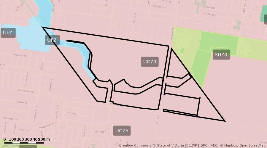
Page 1 of 2 LAND INFORMATION CERTIFICATE SECTION 229 LOCAL GOVERNMENT ACT 1989
Property
interest
PLEASE In with section 175(1) of the Local Government Act 1989, the at the time that person becomes the owner of must be paid by their due dates to avoid penalty at are due by 15/02/2023
10.00% p.a. Full rate payments
Property
This certificate provides information regarding valuation, rates, charges, other moneys owing and any orders and notices made under the Local Government Act 1989, or under a local law of the Council and specified flood level by the Council (if any). This certificate is not required to include information regarding planning, building, health, land fill, land slip, flooding information or service easements. Information regarding these matters may be available from Council or the relevant authority. A fee may be charged for such information. for financial year ending 30th June 2023
the land. All other amounts
Land
Rate CurrentCategoryYear`s General Rates 323,253.19 Current Year`s Garbage Charge 409.00 Current Year`s Fire Service Levy 8,035.20 Current Rates Year`s Charges SUB TOTAL 331,697.39 Current Rates Year Adjust\Payments SUB TOTAL 0.00 Brought Forward Credit -64,946.70 Scheme Charges Scheme Charges - TOTAL 0.00 TOTAL BALANCE OUTSTANDING $266,750.69
Valuation Date 1/07/2022 Effective Date 1/07/2022 Value $149,400,000 Improved Value $149,400,000 Annual Value $7,470,000
Dye & Durham Rates Web Certificates PO Box 447 SOUTH MELBOURNE VIC 3205 Number: 171820 Address: 1275S Pound Road CLYDE NORTH VIC 3978 Description: Lot C PS 846749W Area: 1218500 sqm

Site
Capital
Issue Date: 19 July 2022 Reference: 307372 00369
Property
Details
NOTE:
accordance
Certificate Number: wCerR/C039363
Net
Your
purchaser must pay all overdue rates and charges
Biller Code: 8995 Ref: 01718208
Lot G PS 807039Y ** 1275S Pound Road CLYDE NORTH has not been separately assessed and is subject to a supplementary rate and valuation.
Should you have any queries regarding this Certificate, please contact City of Casey and quote reference wCerR/C039363
Team Leader Rates and Valuations
PLEASE NOTE:
Lot G PS 807039Y ** 1275S Pound Road CLYDE NORTH has been assessed as vacant land. Any improvements made to the property, may be subject to supplementary rate and valuation.
Trevor Riches
Page 2 of 2
Interest continues to accrue at 10.0% on any overdue balances until paid in full.
Telephone & Internet Banking BPAY® Contact your bank or financial institution to make this payment from your cheque, savings, debit, credit card or transaction account. More info: www.bpay.com.au

PLEASE NOTE: If property is assessed as a Part Lot (PT) multiple notices may be required, contact council for further information.
Electronic Payments
PLEASE NOTE: Council will only give verbal updates to the applicant within 60 days of this certificate and it should be noted that Council will only be held responsible for information given in writing, i.e. a new certificate, and not information provided or confirmed verbally. For further information contact Council's Rate Department.

If the property is sold, the vendor is liable to pay all fees incurred in relation to the property until the vendor gives South East Water a Notice of Disposition of Land required by the Water (Disposition of Land) Regulations 2010. Please include the Reference Number set out above in that Notice.
OFFICER: MIKALA CUSTOMERGENERALHEHIRMANAGER&COMMUNITY ENGAGEMENT

Fees relating to the property may change from year-to-year in accordance with the Essential Service Commission's Price Determination for South East Water.
East Water Information Statement Applications

1.Statement of Fees Imposed
If this property has recently been subdivided from a “parent” title, there may be service or other charges owing on the “parent” which will be charged to this property, once sold, that do not appear on this statement. You must contact us to see if there are any such charges as they may be charged to this property on sale and should therefore be adjusted with the owner of the parent title beforehand.
SAI GLOBAL - PSP property.certificates@dyedurham.comE-mail:
* Please Note: if usage charges appear above, the amount shown includes one or more of the following: Water Usage, Recycled Water Usage, Sewage Disposal, Fire Service Usage and Trade Waste Volumetric Fees. Interest may accrue on the South East Water charges listed in this statement if they are not paid by the due date as set out in the bill.
Statement for property: LOT G BREAM STREET CLYDE NORTH 3978 G PS 807039 REFERENCE NO. YOUR REFERENCE DATE OF ISSUE CASE NUMBER 53B//13184/00016 75228196:113062962 11 JULY 2022 41976339
(a)By Other Authorities
(b)By South East Water
The total annual service fees and volumetric fees for water usage and sewerage disposal for each class of property are set out at www.southeastwater.com.au.
PO Box 2268, Seaford, VIC 3198
AUTHORISED
South
TOTAL
Updates of rates and other charges will only be provided for up to six months from the date of this statement.
UNPAID BALANCE $0.00
The property is classified as a serviced property with respect to charges which as listed below in the Statement of Fees.
INFORMATION STATEMENT STATEMENT UNDER SECTION 158, WATER ACT 1989
Financial Updates (free service) are only available online please go to (type / copy the complete address shown below): https://secureapp.southeastwater.com.au/PropertyConnect/#/order/info/update
The map base for any attached plan is not created by South East Water which cannot and does not guarantee the accuracy, adequacy or completeness of any information in the plan, especially the exact location of any of South East Water’s works, which may have changes since the attached plan was prepared. Their location should therefore be proven by hand before any works are commenced on the land.
Any work that requires any South East Water manhole or maintenance shaft to be altered may only be done by a contractor approved by South East Water at the property owner’s cost.
PO Box 2268, Seaford, VIC 3198
Every fee referred to above is a charge against the property and will be recovered from a purchaser of the property if it is not paid by the vendor.
South East Water Information Statement Applications
AUTHORISED OFFICER:
STATEMENT UNDER SECTION 158, WATER ACT 1989
Melbourne Water provides main drainage services to this property, consistent with the standards that applied at the time the Melbourne Water drainage system was constructed. In the event of a storm exceeding the design capacity of the underground / open drain, this property could be affected by overland flows. Please contact Melbourne Water's Waterways and Drainage Group for information available to Melbourne Water on the effect of overland flows on this property. (Telephone 9679-7517)
MIKALA
ENCUMBRANCE ENQUIRY EMAIL infostatements@sew.com.au
For a new connection to our water or sewer services, fees / charges will be levied.
If no plan is attached to this Statement, South East Water is not aware of any works belonging to South East Water being present on the property.
Unless South East Water’s prior written approval is obtained, it is an offence to cause any structure to be built or any filling to be placed on a South East Water easement or within 1 metre laterally of any of its works or to permit any structure to be built above or below any such area.
CUSTOMERGENERALHEHIRMANAGER&COMMUNITY ENGAGEMENT
Information about when and how outstanding fees may be paid, collected and recovered is set out in the Essential Services Commission's Customer Service Code, Urban Water Businesses.
INFORMATION STATEMENT
2.Encumbrance Summary
If a plan is attached to this Statement, it indicates the nature of works belonging to South East Water, their approximate location, and the approximate location of any easement relating to those works.
If this Statement only sets out rates and fees levied by Parks Victoria and Melbourne Water, the property may not be connected to South East Water's works. To find out whether the property is, or could be connected upon payment of the relevant charges, or whether it is separately metered, telephone 131 694.
Where available, the location of sewers is shown on the attached plan. Please ensure where manholes appear, that they remain accessible at all times "DO NOT COVER". Where driveways/paving is proposed to be constructed over easements for water supply/sewerage purposes, or within 1 metre of a South East Water asset, the owner will be responsible for all costs associated with any demolition and or re-instatement works, necessary to allow maintenance and or repair of the asset effected. Where changes to the surface levels requires maintenance shafts/holes to be altered, all works must be carried out by South East Water approved contractors only. For information call 131694. For all other works, prior consent is required from south East Water for any construction over easements for water supply/sewerage purposes, or within 1 metre of a South East Water asset.
Important Warnings
MIKALA CUSTOMERGENERALHEHIRMANAGER&COMMUNITY ENGAGEMENT
INFORMATION STATEMENT
PO Box 2268, Seaford, VIC 3198
This Statement does not contain all the information about the property that a prospective purchaser may wish to know. Accordingly, appropriate enquiries should be made of other sources and information.
STATEMENT UNDER SECTION 158, WATER ACT 1989
This Statement does not include any information about current or outstanding consent issued for plumbing works on at the property.
South East Water has prepared the information in this Statement with due care and diligence. It cannot and does not accept liability for any loss or damage arising from reliance on the information given, beyond the extent set out in section 155 of the Water Act 1989 and sections 18 and 29 of the Australian Consumer Law.
If the owner builds or places filling in contravention of that requirement, the owner will be required to pay the cost of any demolition or re-instatement of work that South East Water considers necessary, in order to maintain, repair or replace its asset.
AUTHORISED OFFICER:
3.Disclaimer
South East Water Information Statement Applications
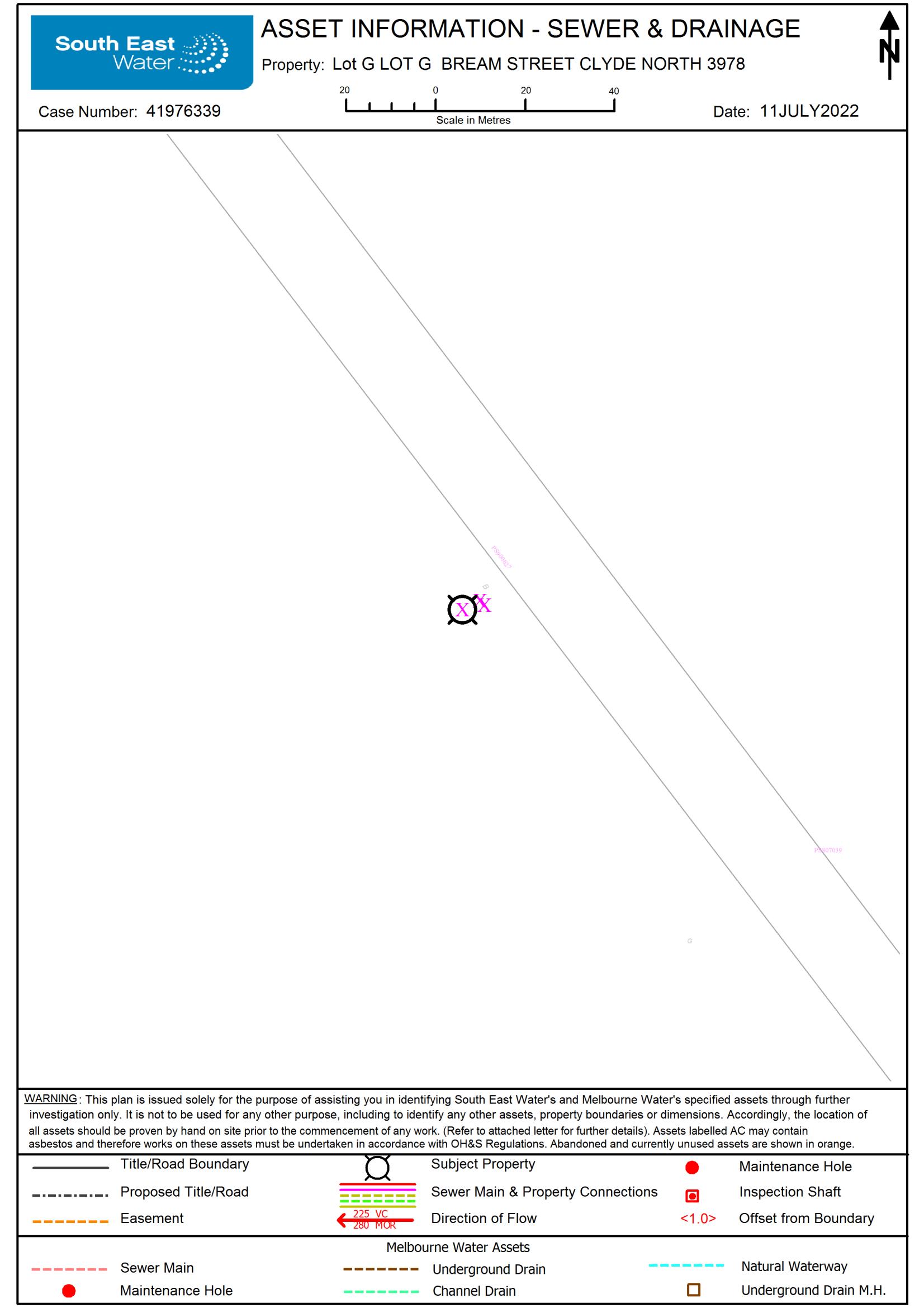
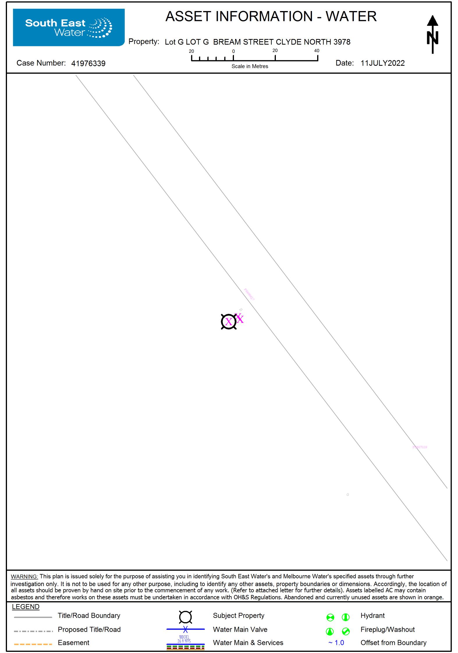
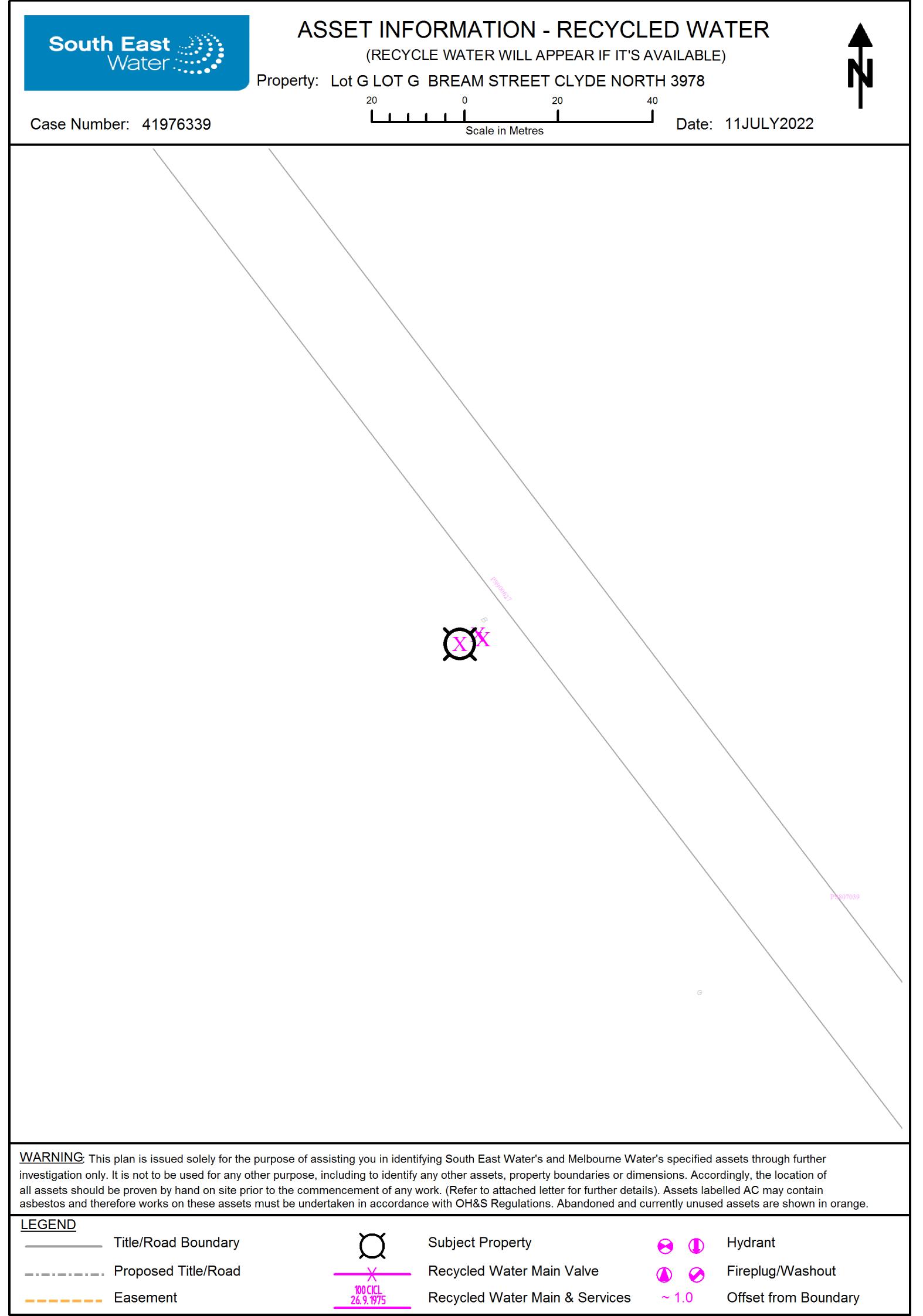
LEVELLTD 20,
Property Clearance Certificate
3000 $64,718,876
Purchaser: FOR INFORMATION PURPOSES
$5,320,591.75AMOUNT PAYABLE: Year Proportional Tax Penalty/Interest Total
Land Id Lot Plan Volume Folio Payable of
Your Enquiries:IssueReference:Date: 75228196:113062961AXW21557262697AUG2022Certificate No:
Commissioner
Proportional
Current Vacant Residential Land Tax Tax TotalPenalty/InterestYear REFER TO ATTACHMENT Value
This certificate is subject to the notes that appear on the reverse. The applicant should read these notes carefully.

&
Taxation Administration Act 1997
Tax
RUSSELL KENNEDY DYE DURHAM PROPERTY PTY 535 BOURKE STREET VIC
MELBOURNE
State Revenue

Comments: Refer to attachment VALUE:
Arrears of
Taxable
Land Address: 1275S POUND ROAD CLYDE NORTH VIC 3978
$64,718,876CAPITAL IMP VALUE: SITE
VIA
Taxable
Current Land Tax Proportional TaxYear REFER TO ATTACHMENT REFER TO ATTACHMENT Value
TotalPenalty/Interest
Land Tax Paul Broderick
Comments: Refer to attachment
Vendor: FRONTLINK PTY LTD
Property Clearance Certificate updates are available at sro.vic.gov.au/certificates
Ref: 57262697 57262697
Taxable Value = $64,718,876
LAND TAX CALCULATION BASED ON SINGLE OWNERSHIP
www.bpay.com.au

Unpaid land tax (including Vacant Residential Land Tax, interest and penalty tax) is a first charge on the land to which it relates. This means it has priority over any other encumbrances on the land, such as a mortgage, and will continue as a charge even if ownership of the land is transferred. Therefore, a purchaser may become liable for any such unpaid land tax.
Certificate No: 57262697
Telephone & Internet Banking - BPAY
Visa or Mastercard
Land tax is a first charge on land
For Information Only
- There is no change to the parties involved in the transaction for which the Certificate was originally requested.
4.3.2.1.
General information
Contact your bank or financial institution to make this payment from your cheque, savings, debit or transaction account.
Code:
Property Clearance Certificate - Payment Options
A Certificate showing no liability for the land does not mean that the land is exempt from land tax. It means that there is nothing to pay at the date of the Certificate.
CARD
Notes to Certificates Under Section 95AA of the Taxation Administration Act 1997
Power to issue Certificate

- The request is within 90 days of the original Certificate's issue date, and
7.6.5.
Despite the issue of a Certificate, the Commissioner may recover a land tax liability from a vendor, including any amount identified on this Certificate.
- Any other information that the Commissioner sees fit to include, such as the amount of land tax applicable to the land on a single holding basis and other debts with respect to the property payable to the Commissioner.
Calculated as $27,975 plus ( $64,718,876 - $3,000,000) multiplied by 2.550 cents.
An updated Certificate may be requested free of charge via our website, if:
Information for the purchaser
The Certificate shows any land tax (including Vacant Residential Land Tax, interest and penalty tax) that is due and unpaid on the land described in the Certificate at the date of issue. In addition, it may show:
Land Tax = $1,601,806.34
Pay via our website or phone 13 21 61. A card payment fee applies. sro.vic.gov.au/paylandtax
- Land tax for the current tax year that has not yet been assessed, and
Amount shown on Certificate
5249 BPAY ®
- Land tax that has been assessed but is not yet due,
Information for the vendor
The Commissioner of State Revenue can issue a Property Clearance Certificate (Certificate) to an owner, mortgagee or bona fide purchaser of land who makes an application specifying the land for which the Certificate is sought and pays the application fee.
BillerRef:
If a purchaser of the land described in the Certificate has applied for and obtained a Certificate, the amount recoverable from the purchaser cannot exceed the 'amount payable' shown. A purchaser cannot rely on a Certificate obtained by the vendor.
LTD
LTD
FRONTLINK PTY LTD
FRONTLINK PTY LTD $191,569.75$203,516.24$228,804.98$228,439.40$527,780.62$2,628.44$1,144.40$1,146.23$1,005.34$946.33
FRONTLINK
PTY LTD
FRONTLINK PTY LTD
FRONTLINK PTY
FRONTLINK PTY LTD
FRONTLINK PTY
FRONTLINK PTY LTD
$204,422.06$203,516.24$228,804.98$228,439.40$527,785.88$2,628.46$1,144.40$1,146.23$1,005.34$1,009.82 $0.00$0.00$0.00$0.00$0.00$0.00$0.00$0.00$0.00$0.00
FRONTLINK
Certificate No: 57262697 Total: Land Id Land Id 1991122819911210 LotLot PlanPlan VolumeVolume FolioFolioGG 807039807039 1238712387 695695 1275S POUND ROAD CLYDE NORTH VIC 3978 1275S POUND ROAD CLYDE NORTH VIC 3978 Land Address: Land Address: $1,380,110.99$6,870.74 Property Clearance Certificate Taxation Administration Act 1997 Tax Payable Tax Payable $5,320,591.75 Comments:Comments:LandTaxDetailsLandTaxDetails Proportional Tax Proportional Tax TotalTotalPenalty/InterestPenalty/InterestYearYear
2015201620172018201920152016201720182019 Taxable Value Taxable Value $10,512,097$10,512,097$23,995,531$9,430,505$9,430,505$119,502$52,662$52,662$46,585$46,585Vacant Residential Land Tax Details Vacant Residential Land Tax Details Tax Liability Tax Liability TotalTotalPenalty/InterestPenalty/InterestYearYear Taxable Value Taxable ValueComments:Comments: 1991122819911210 $1,380,110.99$6,870.74Total Amount Payable for Property: Total Amount Payable for Property:
PTY LTD
FRONTLINK PTY
LTD
Certificate No: 57262697 Total: Land Id Land Id 4866098547149871 LotLot PlanPlan VolumeVolume FolioFolioGG 807039807039 1238712387 695695 1275S POUND ROAD CLYDE NORTH VIC 3978 1275S POUND ROAD CLYDE NORTH VIC 3978 Land Address: Land Address: $1,618,335.11$2,315,274.91 Property Clearance Certificate Taxation Administration Act 1997 Tax Payable Tax Payable $5,320,591.75 Comments:Comments: Land Tax will be payable but is not yet due - please see note 6 on reverse. Land Tax Details Land Tax Details Proportional Tax Proportional Tax TotalTotalPenalty/InterestPenalty/InterestYearYearFRONTLINK PTY LTD FRONTLINK PTY LTD FRONTLINK PTY LTD $1,618,335.11$1,034,821.31$1,280,453.60 $0.00$0.00$0.00 $1,618,335.11$1,034,821.31$1,280,453.60202220202021 Taxable Value Taxable Value $64,718,876$47,040,105$58,026,245Vacant Residential Land Tax Details Vacant Residential Land Tax Details Tax Liability Tax Liability TotalTotalPenalty/InterestPenalty/InterestYearYear Taxable Value Taxable ValueComments:Comments: 4866098547149871 $1,618,335.11$2,315,274.91Total Amount Payable for Property: Total Amount Payable for Property:
DateofSearch: 11/07/2022
PropertyInquiryDetails:
EPAPrioritySites RegisterExtract
FurtherInformation
PrioritySitesRegister
changewithoutnotice.ThePrioritySitesRegisterisupdatedmonthlyandtheinformationonitmaynotbeaccurate,currentorcompleteandmaybesubjectto EPAdirections.risktohumanhealthortotheenvironmentandmustbedealtwithasapriority.Suchsitesaretypicallysubjecttoclean-upand/ormanagementunderindustrialtoresidentialuse.Inmostcasesthesecanbemanagedatthetimethatthechangeoflanduseoccurs.Somesiteshowever,presentapotentialLandcontaminatedbyformerwastedisposal,industrialandsimilaractivitiesisfrequentlydiscoveredduringchangestolanduse-forexample,from Whatareprioritysites? informationaboutpreviouslanduses,anditisadvisablethatsuchsourcesofinformationshouldalsobeconsulted.mayhavebeencontaminatedbypastlandusesandEPAaynotbeawareofthepresenceofcontamination.CouncilandotherplanningauthoritiesholdjustbecauseitdoesnotappearonthePrioritySitesRegister.PersonsintendingtoenterintopropertytransactionsshouldbeawarethatmanypropertiesThePrioritySitesRegisterdoesnotlistallsitesthatareknowntobecontaminatedinVictoria.Asiteshouldnotbepresumedtobefreeofcontaminationenvironment.Suchmanagementcanincludecleanup,monitoringand/orinstitutionalcontrols.thesesitesisnotcompatiblewiththecurrentorapproveduseofthesitewithoutactivemanagementtoreducetherisktohumanhealthandtheTypicallythesearesiteswherepollutionoflandand/orgroundwaterpresentsapotentialrisktohumanhealthortotheenvironment.TheconditionofconditionsofaNoticehavebeencompliedwith.apotentialcontaminatedsiteandthiscannotbecommunicatedbyanyotherlegislativemeans.SitesareremovedfromthePrioritySitesRegisteronceallOntheoccupierorcontrollerofthesitetorequireactivemanagementofthesesites,orwhereEPAbelievesitisinthecommunityinteresttobenotifiedofPrioritySitesaresitesforwhichEPAhasissueda:•CleanUpNoticepursuanttosection62A)oftheEnvironmentProtectionAct1970•PollutionAbatementNoticepursuanttosection31Aor31B(relevanttolandand/orgroundwater)oftheEnvironmentProtectionAct1970•EnvironmentActionNoticepursuanttoSection274oftheEnvironmentProtectionAct2017•SiteManagementOrder(relatedtolandandgroundwater)pursuanttoSection275oftheEnvironmentProtectionAct2017•ImprovementNotice(relatedtolandandgroundwater)pursuanttoSection271oftheEnvironmentProtectionAct2017•ProhibitionNotices(relatedtolandandgroundwater)pursuanttoSection272oftheEnvironmentProtectionAct2017
Client: DX:494MelbourneCertificateNo:75228196:113062965RussellKennedyClientRef:307372-00369
Tothemaximumpermittedbylaw,theEPAexcludesallliabilitytoanypersondirectlyorindirectlyfromusingthissiteandinformationfromit.siteandinformationfromit.Usersofthissiteacceptallrisksandresponsibilitiesforlosses,damages,costsandotherconsequencesresultingdirectlyorindirectlyfromuseofthisdefectsoromissionsintheinformation.suchinformationdoessoonthebasisthattheEnvironmentProtectionAuthorityshallbearnoresponsibilityorliabilitywhatsoeverforanyerrors,faults,TheEnvironmentProtectionAuthoritydoesnotwarranttheaccuracyorcompletenessofinformationinthisExtractandanypersonusingorrelyingupon
AsearchofthePrioritySitesRegister fortheabovemapreference,hasindicatedthatthis siteisnotlistedon,andisnotinthevicinityofasite listedonthePrioritySitesRegister atthedatelastnotifiedbytheEPA.
PrioritySitesRegisterReport:
Page1of1 Dye&DurhamPropertyPtyLtdACN089586872 Level20,535BourkeStreet,Melbourne3000T:1300730000E:epropertysupport@dyedurham.com
Disclaimer
contact@epa.vic.gov.auhttp://www.epa.vic.gov.au1300EPAVIC(1300372842)200VictoriaStreet,CarltonVIC3053EPAVictoriaAdditionalinformationisavailablefrom:

Informationasat31July2021
MapReference:MelwaysEdition39,MapNo:131,GridLetter:D,GridNumber:11Suburb:CLYDENORTHStreetAddress:1275SPOUNDRoad
AUSNET
From www.planning.vic.gov.au at 11 July 2022 02:58 PM
Legislative Assembly: BASS
Address: Lot and Plan Number: Standard Parcel Identifier (SPI): Local Government Area (Council): www casey vic gov au Council Property Number: Directory Reference:
Dimensions for individual parcels require a separate search, but dimensions for individual units are generally not available 570 overlapping dimension labels are not being displayed
All dimensions and areas are approximate They may not agree with those shown on a title or plan Area: 1093145 sq m (109 31 ha) Perimeter: 12 54 km
PROPERTY DETAILS
Southern Rural Water
STATE ELECTORATES
CASEY 174262
This property is in a designated bushfire prone area Special bushfire construction requirements apply Planning provisions may apply
Melway 131 H11
Calculating the area from the dimensions shown may give a different value to the area shown above
South East Water
Legislative Council: EASTERN VICTORIA
PROPERTY REPORT
SITE DIMENSIONS
Rural Water Corporation: Melbourne Water Retailer: Melbourne Water: Power Distributor:
Further information about the building control system and building in bushfire prone areas can be found on the Victorian Building Authority website https://www vba vic gov au

1275S POUND ROAD CLYDE NORTH 3978 Lot G PS807039 G\PS807039
For this property: Site boundaries Road frontages
For more accurate dimensions get copy of plan atTitle and Property Certificates
UTILITIES
Inside drainage boundary
To view planning zones, overlay and heritage information in an interactive format visit https://mapshare vic gov au/vicplan
DEVELOPMENT CONTRIBUTIONS PLAN OVERLAY SCHEDULE 13 (DCPO13)
SCHEDULE TO THE URBAN FLOODWAY ZONE (UFZ)
URBAN GROWTH ZONE SCHEDULE 3 (UGZ3)
This report is NOT a Planning Certificate issued pursuant to Section 199 of the Planning and Environment Act 1987. It does not include information about exhibited planning scheme amendments, or zonings that may abut the land
For other information about planning in Victoria visit https://www planning vic gov au
All or part of this property is an 'area of cultural heritage sensitivity'
If a significant land use change is proposed (for example, a subdivision into 3 or more lots), a cultural heritage management plan may be triggered One or two dwellings, works ancillary to a dwelling, services to a dwelling, alteration of buildings and minor works are examples of works exempt from this requirement
LAND SUBJECT TO INUNDATION OVERLAY SCHEDULE (LSIO)
A planning scheme sets out policies and requirements for the use, development and protection of land This report provides information about the zone and overlay provisions that apply to the selected land Information about the State and local policy, particular, general and operational provisions of the local planning scheme that may affect the use of this land can be obtained by contacting the local council or by visiting https://www planning vic gov au
Planning Zone URBAN FLOODWAY ZONE (UFZ)
URBAN GROWTH ZONE (UGZ)
PLANNING INFORMATION
For details of surrounding properties, use this service to get the Reports for properties of interest
Areas of Aboriginal Cultural Heritage Sensitivity:
Under the Aboriginal Heritage Act 2006, where a cultural heritage management plan is required, planning permits, licences and work authorities cannot be issued unless the cultural heritage management plan has been approved for the activity
For further information about whether a Cultural Heritage Management Plan is required go to http://www aav nrms net au/aavQuestion1 aspx
Planning scheme data last updated on 6 July 2022
'Areas of cultural heritage sensitivity' are defined under the Aboriginal Heritage Regulations 2018, and include registered Aboriginal cultural heritage places and land form types that are generally regarded as more likely to contain Aboriginal cultural heritage
PROPERTY REPORT
Planning Overlay DEVELOPMENT CONTRIBUTIONS PLAN OVERLAY (DCPO)
To obtain a Planning Certificate go to Titles and Property Certificates at Landata https://www landata vic gov au
Under the Aboriginal Heritage Regulations 2018, 'areas of cultural heritage sensitivity' are one part of a two part trigger which require a 'cultural heritage management plan' be prepared where a listed 'high impact activity' is proposed
More information, including links to both the Aboriginal Heritage Act 2006 and the Aboriginal Heritage Regulations 2018, can also be found here https://www aboriginalvictoria vic gov au/aboriginal heritage legislation
All or part of this property is an 'area of cultural heritage sensitivity'
Areas of Aboriginal Cultural Heritage Sensitivity
LAND SUBJECT TO INUNDATION OVERLAY (LSIO)
Selected Property Railway line Railway station Water area Water course Area Map 0 2000 m PROPERTY REPORT
Russell Kennedy via Dye & Durham Property Pty Ltd LEVEL 20 535 BOURKE STREET, MELBOURNE VIC 3000 CERTIFICATE Pursuant to Section 90 of the CatchmentandLandProtectionAct1994 YOUR REF: CERTIFICATE NO: 65171367-021-1 This Certificate is issued for the following property: 1275S POUND ROAD CLYDE NORTH PROPERTY DESCRIPTION: Lot/Plan: Lot G PS807039Y Crown description: Not available Volume/Folio or Book/Memorial: 12387/695 Directory reference: Melways 131C10 Yes/No 1. A regional catchment strategy applies to the land. YES 2. The land is in a special area. NO 3. A special area plan applies to the land. NO 4. A land use condition applies to the land. NO 5. A land management notice is in force in relation to the land. NO 6. A copy of the land management notice is attached. NO By SecretaryAuthoritytothe Department of Environment, Land, Water & Planning DATED: 13 July 2022

The Commissioner may withdraw this clearance certificate at any time if we obtain further information indicating you are a foreign resident.
Our reference: 7128407266163 Phone: 13 28 66
MONDOUS FAMILY TRUST 1B / 4 ROCKLEA DRIVE PORT MELBOURNE VIC 3207 Your foreign
Clearance Certificate Period 5 April 2022 to 5 April 2023
7 April 2022 NATALIE resident capital gains withholding clearance certificate not
› Purchasers are
13 28 66
66
1300000000000000000000210102221100210220200120100033321201200131213 THE TRUSTEE FOR
Notice number 2410647965879
NEED HELP Learn more about foreign resident capital gains withholding at ato.gov.au/FRCGW CONTACT U S

Vendor name FRONTLINK PTY LTD as trustee for THE TRUSTEE FOR NATALIE MONDOUS FAMILY TRUST
If you’re calling from overseas, phone +61 2 6216 1111 and ask for 13 28 between 8:00am and 5:00pm Australian Eastern Standard time, Monday to Friday
We have decided that purchasers are not required to withhold and pay an amount. Your certificate is below:
In Phone us on
Australia?
Hello,
Yours faithfully, Emma Rosenzweig Deputy Commissioner of Taxation
required to withhold and pay an amount › Provide a copy to the purchaser and retain a copy for your records E00000-S00000-F751291 Page74867.397460-09-2020 1 of 1


Municipality Precinct
Owner’s name
Frontlink Pty Ltd ACN 074 034 496
NOTICE OF APPROVAL OF STAGED PAYMENT ARRANGEMENT
Volume
A. APPLICANT DETAILS
Postal address


Kathryn Elleman Russell Kennedy Lawyers 9609 1633 kelleman@rk.com.au
1 TP392956D Casey
property 04024 689 CP-59 P-Cranbourne(part) A 96.00574ha C. GAIC TRANSACTION DETAILS GAIC event (Statement of Compliance PS809748G)* 2 0 *future event (SPA subject to confirmation by SRO of status of secondary school subdivision) D D M M Y Y Y Y GAIC liability (2021-22 financial year rate) $9,602,494.11
type GAIC
Contact details for enquiries
1275S Pound Road Clyde North Subdivision plan structure plan Total area of property Clyde North 135.17414ha Folio land area of
GROWTH AREAS INFRASTRUCTURE CONTRIBUTION (GAIC)
B. PROPERTY DETAILS

c/- 9/484 St Kilda Road Melbourne VIC 3004
In accordance with Section 201SR(4) of the Planning and Environment Act 1987, the Victorian Planning Authority, under delegation from the Minister for Planning, has approved this Growth Areas Infrastructure Contribution (GAIC) staged payment arrangement.
Lot
Page 1 of 4
Full description of whole of the land on which GAIC is imposed
Description GAIC

7- 2.81988 2.94 31/03/2023 26- 0.61132 0.64 30/04/2023
"1D (PS807036F)4.13449 - -----
"1G (PS846748W)4.34996 - -----
"1E (PS807038B)1.50321 - -----
"1H (PS846749U)4.95902 - -----
-----
SPA (no)payment (stage)Estate Non(ha)SPA SPA(ha)area SPA(%)area SPA(%) SPA($) expectedSOC Payment(date)due section 351B (PS846738A)4.01007 - -----
The subdivision area(s) associated with a payment may vary from the applicable area in the schedule by up to 0.50ha, without change to the associated payment amount.
A SPA will not lapse if the subdivision statement of compliance for payment one is issued within 90 days after its PAYMENT DUE DATE provided that the whole of that payment is made within 7 business days of the issue of the statement of compliance. All other payments and due dates in the schedule as approved remain unchanged.
The GAIC notice on any title will not be removed until the GAIC liability including accrued interest applicable to that title is fully paid.
-----
1 (PS809748G)0.32477 5.54838 5.78 31/03/2022
2 (PS809749E)- 3.30491 3.44 30/04/2022
"1C (PS804776D)3.88402 - -----
3 (PS809750V)- 2.58385 2.69 30/05/2022
4- 2.32332 2.42 30/06/2023
67.54624 3.79968 3.96 28/02/2024 214- 4.61910 4.81 4.81 462 002.38 31/03/202530/06/2025
D. SCHEDULE OF GAIC ST AGED PAYMENT ARRANGEMENT
3160.01770 3.06417 3.19 3.19 306 478.28 30/07/202530/06/2026 418- 3.74012 3.90 3.90 374 086.80 30/11/202530/06/2026 510- 1.79614 1.87 1.87 179 649.92 30/03/202630/06/2026 69- 3.53061 3.68 3.68 353 131.61 30/07/202630/06/2027 711- 2.40569 2.51 2.51 240 617.11 30/11/202630/06/2027 8170.00550 2.71254 2.83 2.83 271 308.25 31/03/202730/06/2027 912- 3.38217 3.52 3.52 338 284.64 31/07/202730/06/2028 1013- 3.28188 3.42 3.42 328 253.64 30/11/202730/06/2028 11200.01995 3.21594 3.35 3.35 321 658.32 30/03/202830/06/2028 1219- 2.21053 2.30 2.30 221 097.21 31/07/202830/06/2029 1321- 4.92694 5.13 5.13 492 792.54 30/11/202830/06/2029 1423- 3.07343 3.20 3.20 307 404.47 31/03/202930/06/2029 1522- 3.24036 3.38 3.38 324 100.81 31/07/202930/06/2030 1625- 0.92397 0.96 0.96 92 415.48 31/07/202930/06/2030 1724- 20.14954 20.99 20.99 2 015 356.99 31/07/202930/06/2030 135.17414 39.16840 96.00574 100.00 100.00 9 602 494.11 30/06/2022130.97 2 973 855.66
"1F (PS807039Y)3.03134excluded school1A (PS746170N)5.38213 -
15- 2.36627 2.46 31/07/2022 5- 3.20077 3.33 31/10/2022
8- 3.17423 3.31 31/10/2023
Any other conditions:
The GAIC liability in this schedule is calculated using applicable 2021-22 financial year GAIC rate per hectare of $100,020 for type A land or $118,810 for type B1, B2 and C land.
If the subdivision statement of compliance for payment one is issued after 30 June 2022, the difference between the total liability in the schedule and the total liability calculated using the applicable GAIC rates for the 2022-23 financial year must be paid with payment one. All other payment amounts in the schedule as approved remain unchanged.
An amendment application needs to be lodged at least 20 business working days prior to the next payment due date that is to be amended, failing which the current SPA will lapse.
Page 2 of 4
Page 3 of 4
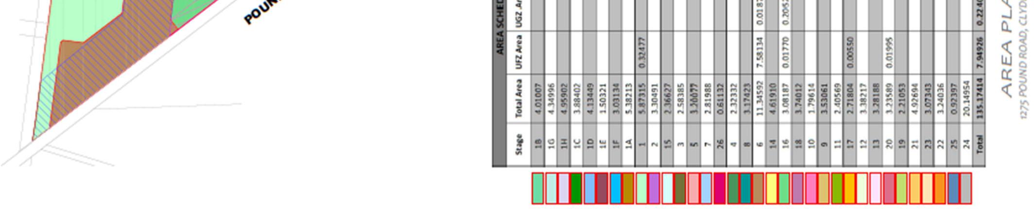
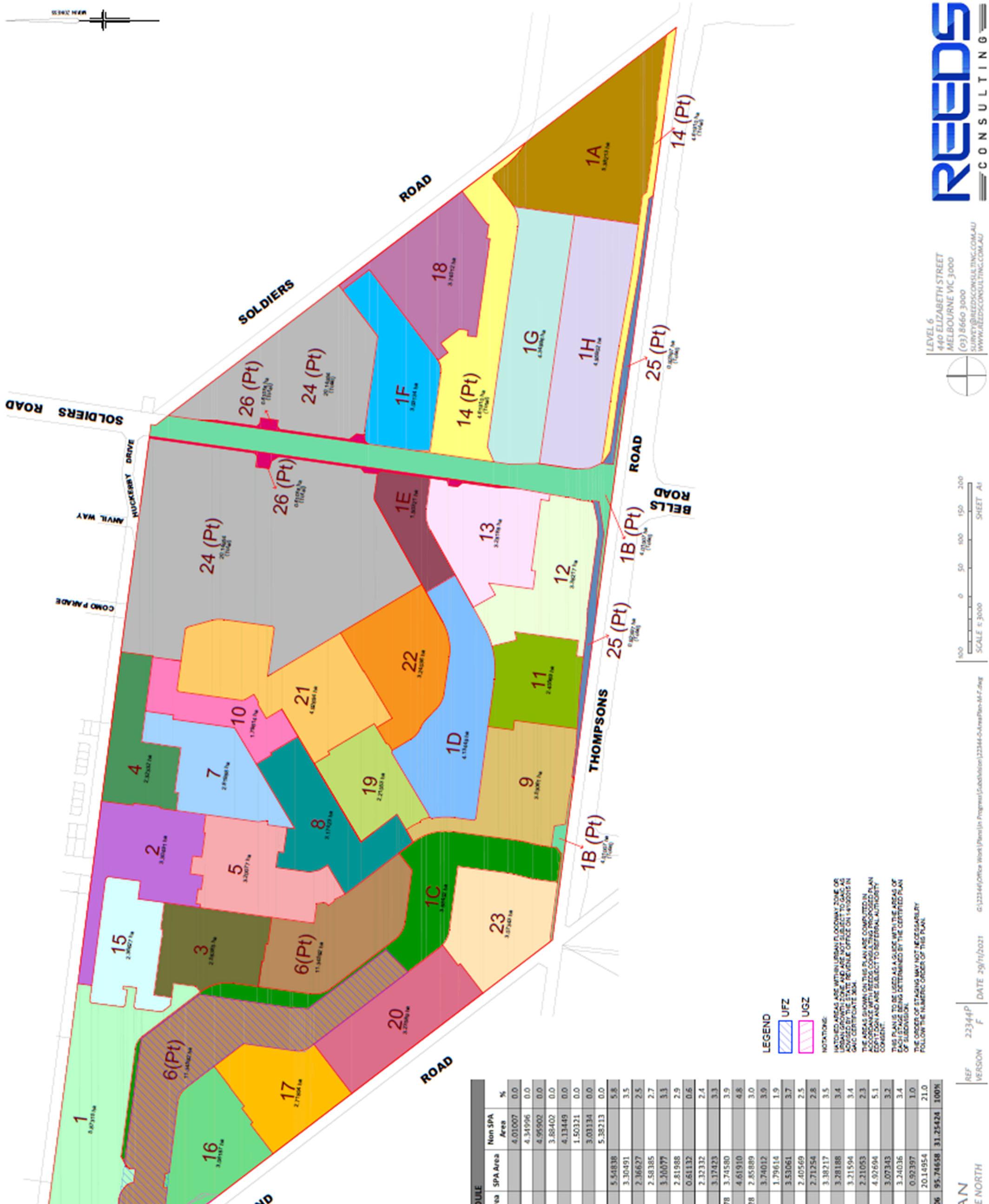
Future GAIC events
However, if the subsequent landowner wishes to amend the schedule of payments or any other condition of this staged payment approval, they have to lodge an application for a further approval.
Name Rachel Dapiran Title Acting Chief Executive Officer, Victorian Planning Authority
Any stage relating to a plan of subdivision not approved under this approval, or amendment to this approval to change the due date for a payment or the amount of a payment specified requires an application to, and further approval from the Minister.
Change of ownership of land subject to this approval
If the whole of the land, the subject of this approval, is sold, the former owner must notify the Minister for Planning of details of the subsequent landowner within 10 days of the land transfer. This staged payment approval is taken to have been granted to the subsequent landowner subject to the same conditions of this approval and on a written application, a new notice of approval will be issued to the subsequent owner.
If this approval relates to a staged payment for a future GAIC event, the GAIC payable set out in the GAIC Staged Payment Schedule is to be calculated using the relevant indexed GAIC rate that applies at the time the actual GAIC event occurs plus relevant interest calculated on a daily basis at the 10-year bond rate applying from time to time during the period of the staged payment approval. Details of the actual amount of GAIC plus interest payable at the relevant specified due date(s) can be obtained from the State Revenue Office.
Failure to comply with conditions ofthe Approval
All the GAIC Staged Payments for this application are to be made in accordance with this schedule. Failure to comply with any condition of this Approval, including a failure to make payments in accordance with the schedule will result in the contribution, plus applicable interest, becoming immediately payable as if the Approval has never been given.
Staged Payments and Interest to be paid toState Revenue Office in accordance with the Schedule
Copy of this Notice
ApplicationSignature Approval Date 2 0 2 2 D D M M Y Y Y Y 1 1 0 1

Page 4 of 4
Issued
The amounts set out in the GAIC Staged Payment Schedule are payable in full to the Commissioner of State Revenue on the stated due date along with any pro-rata interest calculated in accordance with Section 201ST of the Planning and Environment Act 1987. Details of the actual amount of GAIC plus interest payable at the relevant specified due date(s) can be obtained from the State Revenue Office.
Amendment to stages or payments in accordance with the Schedule
The Minister for Planning will provide a copy of this Notice to the Commissioner of State Revenue and to the Victorian Planning Authority under Section 201SU of the Planning and Environment Act 1987 on behalf of the Minister for Planning
promenade village.
design + siting guidelines april 2022
4 built form 9 4.1 architectural style 9 4.1.1 corner and rear access lots (double & single storey) 9 4.2 fibre to the home 10 4.3 external materials 11 4.4 dwelling size 11 4.5 energy efficiency 11 4.6 roofs 11 4.7 garages and carports 12
5 external considerations 13 access and driveways 13 5.2 fences 13 5.3 water saving initiatives 15 5.4 general 15 5.5 landscaping and tree protection 16

3.1 considerations 7 3.2 land use 7 3.3 house orientation 7 3.4 building envelopes, setbacks from front, side & rear boundaries 7
1.5
1.4
1.3
1.2
Berwick Waters is a master planned residential community that is being designed and developed by Frasers Property Australia and Mondous Property Australia. In order to protect your investment, we require that the development of homes maximises a high level of design and quality.
These guidelines deal with the planning and development of vacant residential lots at Berwick Waters, located within the City of Casey.
1.1
2 approval process 5
3.4.1 building envelopes 7 3.4.2 setbacks 8
contents.
3 siting & orientation 7
1 introduction 3 purpose 3 the value of design 3 operation 3 timeliness of application 4 landscaping construction 4
5.1
appendix 17
1.5 landscaping construction
The principal aim of these Design Guidelines (“Guidelines”) is to create a coherent vision for the Berwick Waters community.
To help establish pleasant streetscapes, your landscaping works should be completed within 6 months of Certificate of Occupancy.
1. introduction
1.1 purpose
Developed to enhance the lifestyle and investment of purchasers, the Guidelines are designed to help ensure all homes at Berwick Waters are built to a high standard whilst encouraging a variety of housing styles and compatibility with the streetscape.

The Design Assessment Panel (“DAP”) will be responsible for the review and approvals of your house plans.
However, it is important to note that Covenants or Restrictions on the Memorandum of common provisions cannot be changed by the DAP and therefore must be adhered to at all times.
We recommend obtaining your house plan approvals and building permit promptly as this will provide you with the most flexibility with your design. After houses are built adjacent to your block the Building Regulations will then be applicable and may impact your proposed house design.
Each individual house design should contribute to the surrounding environment and the estate in a positive way.
Owners are encouraged to construct innovative and appropriate designs that address sustainability issues and present a cohesive residential image for the estate.
All proposed building works including houses, garages, outbuildings and fencing are required to be approved by the DAP in relation to these Guidelines prior to seeking a Building Permit. In considering design, the DAP may exercise discretion in limited circumstances to waive or relax a requirement.
The Guidelines will assist in providing you with peace of mind and help protect your investment.
Building Envelopes have been designed for all allotments over 300sqm to ensure homes are appropriately sited with setbacks and height controls to help limit overlooking and overshadowing. These can be found in the Memorandum of common provisions in your contract of sale. Lots 300sqm and under are subject to the Small Lot Housing Code as designated on the Memorandum of common provisions.
1.2 the value of design
43
1.3 operation
1.4 timeliness of application
• Roof plan
step 3 — approval
step 4 — re-submission
The following steps outline the process to construct a house at Berwick Waters.
Plans that do not comply with the Guidelines will be returned with the areas of non-compliance highlighted. Amended plans can be resubmitted for approval.
• House floor plans (1:100 scale)
• Schedule of external materials
• Elevations from four sides (1:100 scale)
• Completed Check List (refer Appendix A of Guidelines)
• Site plan (1:200 scale) showing: setbacks from all boundaries building envelope external features including driveways, paths, fencing and outbuildings - landscaping
-
Note: Design approval from DAP does not exempt the plans from any building or statutory regulations. Separate approval must be obtained from the relevant authorities. Approval by the DAP does not infer compliance under the Building Code of Australia, Rescode and other applicable planning or building regulations.
step 2 submission
step 1 — awareness
-
A Building Permit can be applied for from the City of Casey or a Private Building Surveyor.
Designs are to be submitted in duplicate to DAP for approval as follows:
-
Before you apply for a Building Permit you must first gain approval of your house design from the DAP.
Once a Building Permit has been obtained, and all legal and conveyancing requirements have been met, construction of your house may commence.
step 6 — construction
ApprovedNot Approved
When all documents are submitted (refer Appendix A) and meet compliance, allow approximately 10 working days for approval.
step 5 — building permit
2. approval process
65
Any alterations made to the resubmission other than the initial non-compliance should also be highlighted on the plans or detailed in an accompanying letter.
Homes must be designed in accordance with the Guidelines.

3. siting & orientation
Careful siting of houses and garages is important for a number of reasons:
87
3.2 land use
(a) the front street
3.3 house orientation
3.4.1 building envelopes
3.1 considerations
3.4.2 setbacks
Building Envelopes have been prepared for the lots in each stage at Berwick Waters and are contained within the Memorandum of common provisions. All buildings, including garages, must be contained within the Building Envelope specified for that allotment and in accordance with the profile diagrams.
• Maximising the benefits of solar access
The side and rear setback is also designated on the specified Building Envelope for each allotment. All houses must be set back in accordance with the Building Envelope incorporated into your Memorandum of common provisions. Where an allotment permits building to the boundary on either side, the relevant setback must be applied to the opposite side.
The following setbacks for houses and garages must be met:
• Minimising overlooking
• Respecting the privacy and amenity of neighbours

Houses must face the primary frontage.
In the case of any lot where more than one boundary abuts a road, the shortest of the boundaries which abuts a road is the primary frontage and where there is a splayed corner on a lot, that part of the boundary which is created by the splay (i.e. the corner section) shall be disregarded. Where possible, houses should be sited so that habitable rooms and private open spaces face northwards to receive maximum solar efficiency.
One dwelling only is permitted per allotment. Dual occupancy and further subdivision is not allowed. This excludes those lots designated for multiple dwellings or medium density housing. Refer to the Memorandum of common provisions for details of the expiry of this condition.
3.4 building envelopes, setbacks from front, side & rear boundaries
• Ensuring best visual presentation from the street
• Promoting energy efficiency
The front street setback is designated on the specified Building Envelope for each allotment. All houses must be set back in accordance with the Building Envelope incorporated into your Memorandum of common provisions.
(b) the side & rear boundaries
Fibre to the Home (‘FTTH’) will be provided to parts or all of the development. Due to the provision of FTTH throughout the estate, new technology is employed and as a result the wiring within your house needs to accommodate the fibre as part of its construction. This is something that will need to be addressed as part of the house design, and we therefore recommend that you raise this issue with your builder as part of the design process.
At Berwick Waters, high standards of house design will be required and a variety of styles is encouraged. Designs should be responsive to the individual attributes of the allotment, having regard to any slope or vegetation.
• Front, side street, reserve and rear laneway facing second storey façades must incorporate a habitable room window. They should also incorporate balconies and/or additional setbacks and articulation.
4. built form
Houses with identical façades may not be constructed in close proximity and identical houses must be separated by a minimum of four houses in any direction, excluding multiple dwellings and medium density housing.
Where the DAP considers the dwelling design does not properly or adequately address the street corner and both street frontages, additional treatments may be required to obtain its approval.
• Articulation of some form is required to the upper floor side street elevation.
4.1.1 corner and rear access lots (double & single storey)
Designs that break the front of the dwelling into distinct visual elements will be supported. The inclusion of projections integral to the design and style of the dwellings such as verandas/porticos are encouraged. Further enhancement can be achieved through the use of detail and shade in the form of pergolas and extended eaves.
4.1 architectural style
• For corner and rear accessed allotments, windows that are readily visible from the street must be consistent in style and proportion. These include windows of the front elevation, on the ground floor forward of the corner fence and on the upper storey.
• Double storey homes on corner lots must have a minimum 20% glazing to the upper floor that faces the secondary frontages, measured as an area of the upper floor wall elevation.
Double Storey Corner Treatment. Credit: Porter Davis
Ltd has been selected as the infrastructure services provider for fibre for the development. Refer to their web site for services and retail service providers (www.opticomm.net.au). When you’ve received your Certificate of Occupancy (or 4 weeks before you move in) you will need to call OptiComm to arrange connection to your home.
• Design elements such as verandahs, detailing, feature windows and materials, used on the primary frontage, must continue on that part of the secondary frontage visible to the public realm.
The fibre network has the capability to deliver free-to-air television and some pay TV, therefore you will not require an external television antenna on your roof for these OptiCommservices.CoPty
• Upper floor windows facing a side street are to be clear glass only.
• A feature window must be provided at ground floor level to the secondary street frontage of your home within the first 4m from the front façade and provide a clear view to the secondary streetscape. Highlight windows are not acceptable.
• Double storey dwellings must provide variation in materials between the upper and lower storeys to articulate the corner of both façades.
109
If your home is located on a corner, its design must positively address both the front and side streets, along with any other frontage visible from public open space areas. A consistent architectural style should be used for all visible façades.
4.2 fibre to the home

• The external walls of all other usual outbuildings must be constructed of brick, stone, rendered concrete, concrete sheet, timber or coloured non-reflective metal.
An energy smart home takes advantage of the sun’s free warmth and light and, with the inclusion of energy efficient appliances and systems, will save a great deal of energy. Well-designed homes reduce the demand on heating and cooling. Any style of house can be energy efficient. Energy smart homes have a combination of features that work together to ensure you achieve the highest degree of comfort with minimum energy use.
The garage and family car(s) have a significant impact on the streetscape. The design and location of garages should endeavour to make them an integral and unobtrusive part of the house.
All homes must allow for double garage car accommodation where the primary frontage of the allotment is 12.5m or greater.
• Where the Building Envelope is set back 4 or more metres from the primary frontage, the garage must be sited a minimum of 5.5 metres from the primary frontage;
• Where the Building Envelope is set back 3 metres from the primary frontage, the garage must be sited a minimum of 5 metres from the primary frontage; except in specific instances where the Building Envelopes identifies lots as having an alternative garage setback whereby garages on those lots must not be setback between 3 and 5 metres from the primary frontage.
4.6 roofs
4.3 external materials
1211
Garages must be constructed within the Building Envelope and:
Where a garage is located on a side boundary the garage must not be built forward of the building envelope.
The materials of the walls and roofs of houses will have a major impact on the visual quality of Berwick Waters. The use of a combination of finishes is encouraged for the purpose of achieving a degree of individuality and interest.
Roofing form and controls are to provide visual interest and enhance the building design. All roofs must be constructed of masonry, terracotta or coloured non-reflective metal roofing material.
• At least 50% of the external walls (excluding windows) of all dwellings (including garages and carports) must be constructed of brick, brick veneer, stone, masonry or masonry veneer.
4.4 dwelling size
Thoughtful selection of materials will achieve a degree of visual harmony between houses. For these reasons, purchasers are requested to submit roof and wall materials for approval, based on the following criteria:
The minimum dwelling size will be stated as a Restriction on the Memorandum of common provisions. Site coverage shall be in accordance with the building regulations.
It is preferable for garages to be constructed under the main roof of the house. If garages are free standing and/or visible from the street, they should match the roof form and be constructed of the same materials as the house. The garage door is a major visual element of the streetscape and doors facing the street must be of a colour that complements the house. No roller doors are permitted to the front façade. Where the sides of the garages are constructed facing a street the side of the garage facing the street may be softened by landscaping or alternatively by the inclusion of a window (or windows) in that side wall. Carports can only be constructed if they are not visible from the street.
4.5 energy efficiency
Garage openings must not occupy more than 40% of the width of the primary frontage, unless the dwelling is two or more storeys and on an allotment with an area between 250 to 300 square metres, in which case the garage opening must not exceed 30% of the area of the front façade of the dwelling. The area of the front façade will be measured from a two dimensional elevation plan of the façade excluding the area of the roof of the dwelling.
It is recommended that the minimum Energy Rating be checked with the relevant authority at the time in case there has been a revision of the standard required by the authority.
Homes at Berwick Waters must achieve at least a 6 Star Energy Rating in accordance with the Victoria Home Energy Rating System. A 6 Star Energy Rating certificate will not be required prior to DAP approval; however a certificate will be required prior to obtaining a Building Permit.
4.7 garages and carports
Timber Pailing Fence Materials 4m
Driveways are a major visual element at Berwick Waters and should be constructed using materials that blend with or complement the dwelling textures and colours.
SIDE FENCE SIDE FENCE PRIMARY FRONTAGE BUILDING PERMITTEDENVELOPESTARTOF SIDE FENCE SIDE FENCE PRIMARY FRONTAGE BUILDING
For corner lots where the lot depth (excluding the corner lot splay and any electrical substation reserve in the rear of the lot) is:
Capped 6m Lot 1.2m 2.0
m
4m
Capped
5. external considerations
Recommended paving materials include stone, brick, exposed aggregate or coloured concrete. All driveways must be completed prior to anyone moving into the house.
On side boundaries, no fencing is permitted between the primary frontage and the front of the Building Envelope that is the closer to the primary frontage of the adjoining allotments. PERMITTEDENVELOPESTARTOF PERMITTEDENVELOPESTARTOF FRONTAGEBUILDINGPERMITTEDENVELOPESTARTOF
The objective of the DAP is to provide a degree of uniformity throughout the estate and thereby avoid an untidy mix of various fence standards, colours and types.
2m Height taper 4m 32 Meter
4m 6m
To enhance the park-like character of the estate, front fencing will not be permitted.
Only one driveway will be permitted for each lot, unless there are special circumstances, which will be considered by the DAP.
Timber Pailing Fence Materials Secondary Frontage Fencing Example–Resident Installed
All side and rear fences are to be constructed of timber palings with a timber cap across the top, exposed timber posts on both sides of the fence, and to a height between 1.8 and 2.0 metres, including capping (excluding a screen required for overlooking purposes). In the instance of a fence erected by the developer a side fence may be constructed of a combination of a timber & steel/aluminum with possible stone elements.

All fences located on the secondary frontage, regardless of the lot depth, must return to the dwelling at 90 degrees at the point of termination of the 1.8–2.0m high side fence section. 6m 2m Height taper 4m Meter Lot 4m 6m 1.2m 2.0 m
• greater than 21 metres, the fence located on the secondary frontage must either end a minimum of 6 metres behind the front facade or transition down to a height of 1.2m or less over the next 2 metres from which point it can then continue to the front facade. Refer to image below.
Driveways to all allotments must be set back a minimum of 0.5 metre from the side boundary to allow for landscaping along the length of the driveway.
SIDE FENCE SIDE FENCE
5.1 access and driveways
BUILDING
SIDE FENCE SIDE FENCE PRIMARY
If a new driveway is constructed to match the house design, the existing driveway must be removed at the time the new driveway is constructed.
• 21 metres of less, the length of the 1.8–2.0 metre high section of fence located on the secondary frontage must not exceed 60% of the depth of the lot (excluding the corner splay) taken from the rear boundary towards the primary frontage. The fence can then transition down from 1.8–2.0 metres in height to 1.2 metres or less over the next 2 metres from which point it can then continue to the front facade.
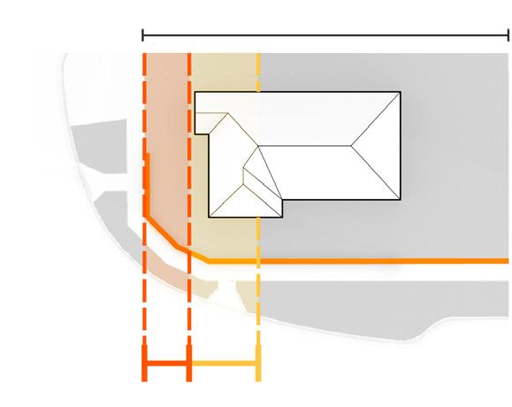
1413
32
5.2 fences
5.5 landscaping and tree protection
Front and side nature strips are Council-owned land however the maintenance responsibility rests with the allotment owner or tenant. Any street tree located within a nature strip cannot be removed without Council approval.
Air-Conditioning Units Both refrigerated and evaporative air-conditioners must be positioned so that they are not visible from the primary frontage and the street abutting it. They must be painted to match the colour of the roof, be low profile units and installed as low as possible below the roof ridgeline towards the rear of the house.
• Garden irrigation drip system (rather than sprayers)
• Front loading washing machine (AAAA rating or greater)
Recycled water is mandated through the development. South East Water requirements for supply are to be complied with; please speak to your builder about this.
• Garden with native plant species, or other appropriate drought tolerant plants
Front Gardens
Satellite Dishes will only be approved if they are not visible from the primary frontage and the street abutting it.
1615
Rubbish Bins & Recycling Bins should be stored out of view from the street. Bins are to be retrieved from the street and stored away in accordance with local bylaws.
The objective is to achieve a cohesive blend of indigenous vegetation and other landscape elements, integrating street landscaping with private gardens so that the streetscape presents as a landscaped garden.
Rainwater Tanks must not be visible from the primary frontage and the street abutting it.
All landscaped areas between the primary frontage and the dwelling should be established within 6 months of the issuing of the Occupancy Permit to ensure that a good presentation is achieved for the local community.
External fixtures must adhere to the following principles and the location must be noted on plans to be submitted to the DAP: Clothes-lines, Garden Sheds, External Hot Water Services and Ducted Heating Units or similar must not be visible from the street.
After settlement, you become responsible for the maintenance of your allotment, even if no construction has begun, and we recommend keeping the allotment neat and tidy to avoid any possible Council Infringement Notices being issued to you.
General Guidelines
Wall mounted air-conditioners must be located below the eaves line, screened so they are not visible from the primary frontage and the street abutting it and suitably baffled to reduce noise.
• completion of a dwelling, whichever occurs first.
Solar Water Heaters are permitted and, where possible, are to be located out of view from the primary frontage and the street abutting it. The solar panels shall be located on the roof, not on a separate frame, and the storage tanks detached and located out of view from the street frontage.
Landscape design and plant selection should minimise the need for garden watering. Purchasers should make their own enquiries with the City of Casey and obtain a list of recommended vegetation.
Advertising Signage is not permitted on any residential lot except when the lot is being sold after:
Berwick Waters is committed to saving water and encourages all residents to consider water saving initiatives in the home including:
• Rainwater to infiltrate into the garden as opposed to draining out to the stormwater system
• the expiration of 5 years from the registration of the Plan of Subdivision, or
5.3 water saving initiatives
5.4 general
• Dishwasher (AAAA rating or greater)
5. Fencing
Front, rear and both sides.
Location, height and materials of all boundary fencing.
Documentation required to be submitted for approval to the Berwick Waters Design Panel.
A copy of this form must be included with the lodgement of plans for approval.
1. Site Plan
4. Schedule of external materials and colours
Each box is to be ticked. Applications cannot be assessed until all of the above information is available.
Owner/Builder (Please circle)
Frasers Property Australia Level 9, 484 St. Kilda Road Melbourne 3004

checklist
6. Landscape plan and planting proposal
appendix a: design guidelines
Walls and roofs of house and outbuildings.
Lot PreferredOwner’sStreetNo:Address:Name:Contact No: Builder’sAddress: Name: Contact Name: Contact SignatureNo:of
2. Floor plans fully dimensioned House only.
3. Elevation fully dimensioned
Email: FPA.Approvals@frasersproperty.com.au
Date / /
Or post: Berwick Waters Design Approval
17
Including dwelling, carports, garages and outbuildings. Including dimensioned setbacks from all boundaries.
Please submit the above documentation to:
the pride of the south-east. 13 38 berwickwaters.com.au38
dlcs SO1001 e d SO5001 e d S001c e d CONSTRUCTIONPLAN WARNING 1050 20 ScaleScale1:500@A11:1000@A3


DISCLAIMER
CHANGES.COUNCIL,ONLYTHECONTENTONTHISPLANISFORPRELIMINARYPURPOSESANDISSUBJECTTOTHEFORMALPLANNINGAPPROVALBYDETAILEDENGINEERINGDESIGNANDAPPROVALSFROMTHECOUNCILANDALLSERVICEAUTHORITIES.ASSUCHTHISPLANISSUBJECTTOCHANGEWITHOUTNOTICE.THISPLANISNOTTOBEUSEDFORANYPURPOSEOTHERTHANFORPRELIMINARYPURPOSES.HOUSESITTINGSHOULDONLYBECOMPLETEDONCECOUNCILAPPROVEDPLANSAREISSUED.THEDEVELOPERBEARSNORESPONSIBILITYFORANYOFTHESETHEPURCHASERSHOULDASCERTAINTHEDETAILSARECORRECTBEFOREPROCEEDING.
dlcsSSO1001eidO45001efidSO9001cred CONSTRUCTIONPLAN WARNING 0510 20 ScaleScale1:500@A11:1000@A3
DISCLAIMER CHANGES.COUNCIL,ONLYTHECONTENTONTHISPLANISFORPRELIMINARYPURPOSESANDISSUBJECTTOTHEFORMALPLANNINGAPPROVALBYDETAILEDENGINEERINGDESIGNANDAPPROVALSFROMTHECOUNCILANDALLSERVICEAUTHORITIES.ASSUCHTHISPLANISSUBJECTTOCHANGEWITHOUTNOTICE.THISPLANISNOTTOBEUSEDFORANYPURPOSEOTHERTHANFORPRELIMINARYPURPOSES.HOUSESITTINGSHOULDONLYBECOMPLETEDONCECOUNCILAPPROVEDPLANSAREISSUED.THEDEVELOPERBEARSNORESPONSIBILITYFORANYOFTHESETHEPURCHASERSHOULDASCERTAINTHEDETAILSARECORRECTBEFOREPROCEEDING.
PRELIMINARY 0 50100 100 150 200 22344P A B C (03) 8660 3000 WWW.REEDSCONSULTING.COM.AUPLANNING@REEDSCONSULTING.COM.AU MELBOURNE VIC 3000 440 ELIZABETH STREET LEVEL 6 1i 30 1i 301i 301in 301i 50 1in 30 1i 30 L O T S 0.05 <>GAS 2.10 37.00 PATH FOOT 1.50 PARKING BAY 2.30 PARKING BAY 2.30 A G:\22344\Office Work\Plans\In Progress\Development Plan\EDP1S-7.dgnS-7 SCALE 1: 2000 @ A1 NATURE STRIP 3.50 LANE BICYCLE 1.70 TRAFFIC LANE 3.50 TRAFFIC LANE 3.50 LANE BICYCLE 1.70 OUTER SEPARATOR 8.00 TRAFFIC LANE 5.50 NATURE STRIP 3.45 WATER 2.50 WATER <>POTABLE 2.90 <>TELECOMM 0.800 <>ELECT 1.30 ESTATE DEVELOPMENT PLAN HONOUR VILLAGE 1275 POUND ROAD, CLYDE NORTH REF VERSION SHEET A1SCALE 1: 3000 SCALE 1: 25 @ A1 SCALE 1: 2000 @ A1 DATE 05/04/2022 ELTIT (120) (10417) 60 60 60 94 ) ) S.S. S SS S SS 60 12 87 83 59 60 6094 0 7 S.S. SS * * * * * ROAD3 ROD2 ROAD3ROAD3 RROAD3OD5ROAD5 ROAD6 ROD8 ROAD8 OAD8 ROAD9 ROAD9 ROAD9 RAD9 ROAD10 ROAD10 ROAD10 ROAD12 ROD13 ROAD15 OAD16 OAD16 RAD17 ROAD18 ROAD14ROAD20 ROAD19 ROAD22 ROAD25 ROAD31 ROAD31 ROAD31 ROAD31 ROAD32ROAD36 ROAD35 ROAD33 ROD34 ROAD38 ROAD42 ROAD43 ROAD43ROAD44 ROAD44 ROAD37 ROAD40 ROA40 ROAD45 ROAD42 ROAD39 ROAD18 ROAD27 ROAD24 ROAD26 ROAD24 ROAD21 ROAD27 ROAD20 ROAD 4 ROD8 ROAD7 ROAD7 ROAD9 ROAD22 ROAD 23 RADIANT R36OAD 4ROAD ROAD23 ROAD 3 BOULEVARDRADANTBOULEVARD The waterways within the encumbered open space reserves are indicative only and subject to the approval of the Responsible Authority. provided within the road reserve at a rate of one car parking space per lot accessed from the driveway link. Where extended driveways are proposed, the width of the driveway is indicated on this plan. Car parking for these lots will be The shared path will be provided at the time of construction within the proposed road reserve. Bells Road has been designed in accordance with Cross Sections 14 and 15 in the Clyde North PSP which both contain a shared path. constructed at the full cost of the developer. To be constructed at the time of the relevant abutting Stage. A 3 metre wide concrete shared path will be provided along the Thompsons Road frontage of the site when Thompsons Road is beVicroads.addressed on the formal Plan of Subdivision and will be in accordance with the requirements of the Responsible Authority and Should additional land be required as a result of the detailed design plans having been prepared, then this canadvice from VicRoads. The land required for the intersection flaring and the ultimate Thompsons Road reservation has been provided in accordance with can be provided on the formal Plan of Subdivision. accommodate the proposed traffic treatment. However, should additional land be required by the Responsible Authority, then this The splays on the southern side of Honour Avenue at the roundabout with Riverstone Boulevard and Como Parade are adequate to The service road in Stage 1 will function as a one way road, with traffic flows only permitted from east to west. The lots to the north of the intersection of Radiant Boulevard and Road 3 will not be accessed from a roudabout. indicative only. No reliance should be placed on the information on this plan for detailed design or for any financial dealings involving the land. heritage assessments and other site investigations may result in changes to the design. All landscape, kerbs and paving detail shown hereon is of the hydrological assessment and approval from council and all other relevant authorities. Findings from flora and fauna reports, cultural Reeds Consulting PTY LTD. The plan is subject to survey, title and easement verification, engineering design, recommendations/ management This plan has been prepared for review and comment only and should not be used for any other purpose without the written consent of Additional traffic calming measures may be incorporated into the future subdivision of the site, as part of the detailed engineering design. Budget contained within the Clyde North Development Contributions Plan. Despite the areas summarised on the plan, any development contribution levies paid and collected will be done so in accordance with the Land Use The road widenings, as required by VicRoads, will form part of a GAIC exemption Plan of Subdivision (Stage 25). The Encumbered Open Space for drainage purposes will be excised out of the overall site as Section 35 plans (Stages 1C, 1D, 1E & 1F). The UFZ land not subject to GAIC will be created as formal reserve (for drainage purposes) on the relevant stage as shown on this plan. This plan has been prepared in support of planning permit PlnA00048/16. The Subject Site is comprised of one Certificate of Title, being Lot 1 on TP392956 (Vol. 4024 Fol. 689). Turning areas provided at no-through roads will be designed to meet the GAA Engineering Construction and Design Manual for Subdivisions. will be placed on Title to identify each lot as "Type A" or "Type B" under the Small Lot Housing Code. The Small Lot Housing Code applies to the construction of a house and associated outbuildings on lots less than 300 square metres. A Restriction Stage numbers are descriptive only and may not indicate the sequence of the subdivision refer to the Stage Sequencing Order table. referral authority approval. The locations of bicycle lanes, shared paths, footpaths, driveway links and bus stops are indicative only and subject to engineering design and The location of substations is indicative only and will be confirmed once the staging of the subdivision has been determined. 4959ha 5382ha 42305ha 1361ha 5362ha 0.761ha 826m 506h 3031ha 1734ha 9236m² 6 721m 0194ha 1427ha 5352ha 03557h 20282ha 14072ha 3883ha 4350ha 1.522ha 25 25 3 25 25 20 25 5 34 1 1 16 14 14 14 1 1 3 2 3 2 4 1 2 8 6 16 16 3 3 1 6 3 2 2 3 3 16 13 1 6 0 4 32 16 16 26 4 5 2 1 3 0 3 8 1 0 5 70 16 5 1 8 3 8 0 2 3 9 112 1 16 16 0 1 1 3 16 14 1 1414 16 3215 15 14 15 0 8 32 28 16 32 0 32 2 4 1 6 7 6 6 16 14 2 1 18 15 5 5 0 1 3 2 6 4 5 8 33 6 1 0 15 30 16 9 37 14 14 14 1 0 6 5 2 4 16 16 3 2 8 4 3 1 0 1 5 2 14 2 1 5 2 4 2 50 ( 0 1 0 25 4 4 8 4 0 4 4 6 4 1 4 4 4 4 6 8 1 1 1 9 1 1 ) 0 6 9 1 1 15 1 1 7 ( 14 14 16 14 ( 3 5 9 5 9 5 1 2 ) 2 0 3 9 1 0 0 1 12 8 ( ) 3 1 2 0 R 3 3 8 1 8 8 1 R 2 5 (5 7 5 R R A 6 1 ( 37 1 ) 2 3 4 4 0 1 6 0 3 3 9 1 1 3 2 2 4 4 R 8 R 3 2 2 2 3 3 4 6 1 1 1 4 1 4 64 14 1414 2 5 25 1 16 6 8 45 8m 63 8 32 8m 78 35 4 44 4 m ² 5 48 2 49 12 5m 4 ² 5m 12 0 40 00 6 15 4 4 47 52 6 0 12 m 3 6 75 6m 57 12 44 00 0m 0m 8m 44 48m 48m 00 00 51 51 4 m 5 ² 48 52m 76 91 8 48 4 ² 56 ² 57 m 6 ² 6 48 4 6 1 0 4 5 8 0 8 12 5 40 40 0m 0m 4 4 m ² 40 40 00 40 6m ² 7 ² 78 5 ² 50 38 00 2 m ² 28m 3 m 2 2m 3 m 48 8 00m 4 m 44 4 5 552 32 8 44 4 0 4 4 5 554 4 4 40 00 4 4 4 40 8 2 4 9 8 2 m 4 1 0 0 4 44 4 8 4 728 7 4 4 38 512 4 44 9 6 8 44 48 8 4 0 5 4 44 2 76 5 m 4 4 8 7 m 51 5 ² 2m 42 60 m 3 5 512 452 m 4 40 451 8 6 448 448 8 400 0 0 48 4 0 0 83 m 7 576 51 00 0 61 5m ² 2 4 4 8 5 8 12 00 44 48 ² 12 2m 5 m 5 m ² 6 5 28 76 4 8 49 4 44 400 00 40 400 4 1 1 92 2 48 ² 50 00 66 5 9 1 4 00 51 73 8 m 7 4 8 m 40 40 4 400 2 ² 71 85 76 5 ² 42 8 12 00 00 6 72 4 0 0 4 1 4 4 m 8 48 4 12 4 3 2 23 5 48 m m 8 8 44 4 0 8 4 2 5 5 2 m m 448 8 4 4 54 48 4 07 8 4 0 4 4 4 m 7 m 344 69m 3 4 m m m 9 7 0 48m² 8 ² 512 40 40m² 44 51 4 4653m² 8 4 8 0 0 0 5 6 4m 0 0 4 8 4 4 8 7 4 4 5 4m 48 92 2 2 1m 4 4 4 4 8 8 4 4 8 1 4 4m 8 5 2 4 4 8 53 577 60m 50 4 8 5 8 7 m 8 4 8 5 8 645 0 4 8 m 4 74 1 9 1 4 5 4 4 1 6 m 7 m 4 576 m 7 400 m 40 4 5 2 m 4 50 40m ² 3 m ² 0m ² 92 8m 40 39 38 2 m 7 8 48 4 m 56m 40 00m 0m 12m 7 7 92 35 76 39 44 48m ² 48 48m 448 400 4 m 5 40 00 ² 7m 71m² 44 00m 51 51 52m² 6m 50m ² 52 52m 5 4 1 48 4 8 ² 48m ² 48m 44 51 12 52 ² 6 ² 4 5 12 12 1 2 448 4 5 1 448 51 5 392 8 8 3 8m 12 35 39 0 50 35 4 48 3 5 1 5 2 7 1 m 7 00 00 8 9 4 51 4 0 0 4 8 4 3 4 2 536 8 m 77 79 THOMPSONS ROAD POUND ROAD ROAD A N V I L W A Y HONOUR HONOUR HONOUR AVENUE AVENUE B O U LE V A R D R A I A N T B O U LE V A R D R I E R S T O E SOLDIERS HUCKERBY DRIVE S O LD I E R S R O A D AVENUE HUCKERBY DRIVE P A R A D E C O M O C O M O P A R A D E R O A D B E LLS ( A R T E R I A L R O A D ) B E LLS R O A D NOTATIONS LEGEND (MELBOURNE WATER DRAINAGE2 RESERVE) BUS ROUTE & INDICATIVE BUS STOPS (BOTH SIDES) SHARED PATH (2.5m WIDE) SUBSTATION SITES (min 5.6m x 8m) LAND SUBJECT TO S.35 GAIC EXEMPTION UFZ LAND (GAIC EXEMPT - 7.951ha) PROPOSED RESTRICTEDSIGNALISEDSTAGINGINTESECTIONVEHICULARPARKING ACCESS TREE UNENCUMBEREDSCHOOLRESERVESITE ACTIVE OPEN SPACE UNENCUMBERED OPEN SPACE ECUMBERED OPEN SPACE (DESALINATION PIPELINE) ENCUMBERED OPEN SPACE FUTURE DEVELOPMENT SITES MEDIUM DENSITY LOTS (<300m²) - SMALL LOT HOUSING CODE TYPE A OR B CONVENTIONAL LOTS SUBJECT SITE 101 102 103 10 10 106 7 108 09 0 1 2 49 1 33214 3 47 0114 141414 8 3 14 5 16 7 8 19 12 1 1 1 1 12 1 127 128 9 1 03 15 5 15 07 15 1 1 1 51 14 15 1516 1517 1518 1519 20 1530 1531 152 3 11 61152 5 9 1532 1533 1534 53 309 310 219 220 216 217 218 330 3 3 3 03 30 3 306 307 311 312 313 314 315 316 317 318 319 320 321 322 323 324 325 326 327 328 329 331 333 334 335 336 337 338 339 340 1 2 4 205 06 20 2 05 4 07 8 40 10 411 4122211 112143 1008 221 530 222 223 224 225 226 227 228 229 230 231 232 233 234 235 236 23 3 2 701 702 703 704 705 706 707 708 710 711 721 1 16 1824 1840 1429 1801 14 18 1823 11828 8291830 501 502 503 504 505 506 507 508 509 510 511 512 513 514 515 631 516 517 518 804 805 806 807 809 519 520 521 522 540 539 523 524 525 526 527 528 529 531 532 533 534 535 536 1 537 538 543 544 545 546 547 548 549 623 624 625 626 627 628 629 630 620 6621 22 608 609 610 611 612 613 614 601 602 603 604 605 606 607 801 802 803 810 811 812 813 8 4 815 816 8 8 819 820 821 8822823824825826827 28 8829830831832833834835 36 837 838 839 840 842 901 902 903 04 9 907 9 9 111 3 99915 1 918 919 920 921 922 92 92 92 9 7 8 92 9 933 934 935 936 937 938 939 94 101 02 03 1104 1105 1106 1107 1108 1109 1110 1 11 1 1114 1115 1116 1117 1118 119 0 21 1 1123 1124 1125 1126 1127 8 2 11 1131 1132 1133 1134 1135 1136 1137 1 20 20 20 1204 1205 1206 1207 1208 1209 1210 1211 2 22 1213 1212 1214 1215 1216 1217 1218 1219 1220 1221 1 1 1226 1227 1228 1229 1230 1231 1232 1233 1234 1235 12 3 12 1239 1 1245 1246 1301 1302 1 03 1304 1305 1306 1307 1308 1309 1310 1311 1312 1313 1314 1316 1317 1318 1319 32 21 32 1323 1331 2103 2210521062107210210921102111 112 2113 114 2115 2116 2117 22118 1 292122121 122 2123 212 2125 2126 2 27 2128 2129 2130 22131 132 2133 2134 2 35 1901 1902 1903 1904 1905 190611907 9081909 1910 1911 912 1 13 1914 1915 916 1917 1191819191920 92 11922 9 13 924 1925 1926 1927 928 1929 1930 1931 193 2201 2202 2203 2204 220 2206 2207 2208 2209 2 2212222 223 2225 22 2231 2220 2213 1701 2001 2002 2003 2004 2005 2006 2007 2008 2009 2010 2011 2012 2013 2014 2015 230122016201720182019 020 2023 2202420252026202720282029203020312032 033 2034 30 2305 2310 23 16 2317 2 2327 615 616 617 618 619 3 4 2306 2307 2308 2309 2231123122313 314 2318 2319 2320 2321 2322 324 5 23 2328 2329 2330 2331 2332 2333 1702 1703 1704 170517061707 170817091710 1711 1712 1713 1714 11715171617171718 719 117201721 722 1723 1724 1725 1726 1727 17281729 173017311732 1733 1734 118251826 827 6 15 15 9 54 541 2101 2102 22 22 22 222152162217 218 2212 22211 210 1601 1602 61 1628 1604 2104 2138 2139 2140 2141 2142 2143 2144 2136 2137 2236 2021 2022 2214 22192224 23 2232 2233 2234 2235 2237 2238 2239 2240 709 712 713 714 715 716 717 732 13 5 16 18 7 1 02 03 404 14 1 1 140 14 1 11 1 3 14 5 416 14 14 14 20 42 1 3 4 1 14 8 1430143114321433 1802 1803 1804 1805 7 18 80 0 181 81 1 81 5 16 1 8 181 0 1 18311832 18331834 1835 1836 1837 1838 1839 18411842 1843 1844 1845 1846184718481849185018511852 1185318541855 856 1185718581859 860 1186118621863186418651866 867 1186818691870 871 1603 1605 718 719 720 722 723 724 725 32 11010 07 1009 1010 1011 1012 1013 1014 1015 110110181019 020 1021 1022 1023 81024 08 726 727 7283230 1 733 734 735 736 737 738 739 740 741 742 743 1606 1607 16081609 1610 1611 11612 613 16111616 6 0 1 1 16 5 62 1629 1630 1631 42 4 43 2 43 841 817 34 435 1240 31241 1 1315 1324 1325 1326 1327 1328 1329 1330 1332 1333 1334 1335 1336 1337 1338 1339 1340 1735 441942442242 2 6 12m 6458m² SEEENLARGEMENT1 SEECROSS SECTION1 ENLARGEMENT 1 UNENCUMBEREDPUBLICSPACE(NP2)"A"OPEN DESALINATIONPIPELINEEASEMENT DESALINATIONPIPELINEEASEMENT &UDFAPPROVAL PERMITAPPLICATION SEPARATEPLANNING SITE SUBJECTTOA FUTUREDEVELOPMEENT TO BE COLLEGERETAINEDCARPARK HILLCREST CHRISTIAN EXISTING ACCESS TO TO BE HILLCRESTCOLLEGERETAINEDCARPARKCHRISTIANEXISTINGACCESSTO HILLCREST CHRISTIAN COLLEGE SEALED ROAD ACCESS TO RESERVE IS TO PROVIDE ULTIMATE THE EXISTING SOLDIERS ROAD CROSS - SECTION 1 (HONOUR AVENUE) 37m UPS(NP6)PACE"C"UBLICOPENNENCUMBERED BELLSROAD)0428ha(THOMPSONSROAD/DoTROADWIDENINGOFSTAGE14 APLAN&LINKEDTOTHEPRACTICALCOMPLETIONCCORDANCEWITHTHEPUBLICINFRASTRUCTURE THEINTERSECTIONWORKSWILLBEUNDERTAKENIN OF02ha(RD21CLYDENORTHDCP)INTERSECTIONFLARING APROALARSUJECTOICRADRIGTTUNOVEENS(NP7) POS D" UNENCUMBERE2D E R R R 12TREE RESERVE DRAINAGERESERVE) (MELBOURNEWATER SPACE"G" ENCUMBEREDOPEN UPS(NP4)PACEB"UBLICOPENNENCUMBERED DRAINAGERESERVE) (MELBOURNEWATER SPACE"F" ENCUMBEREDOPEN 6mDESALINATIONPIPELINEBUFFER 6mDESALINATIONPIPELINEBUFFER SCHOOL STATESECONDARY TREE RESERVE FUTURESCHOOLGOVENMENTFORMPARTOFTHETOVEHICLESANDTOROADTOBECLOSED STAGE 14. PROVIDED WITH OTHERS. LAND TO BE CONSTRUCTED BY ROAD (429m²) TO BE 12mTREE RESERVE BELLSROAD)0496ha (THOMPSONSROAD/ DoTROADWIDENING OF02ha(RD20CLYDENORTHDCP)INTERSECTIONFLARING SEREERT ENLARGEMENT 2 APPROVAL SUBJECT TO COUNCIL IS INDICATIVE ONLY & IS ROAD SHOWN DOTTED &UDFAPPROVAL PERMITAPPLICATION SEPARATEPLANNING SITE SUBJECTTOA FUTUREDEVEOPMENTOFSTAGE14 PLAN&LINKEDTOTHEPRACTICALCOMPLETION ACCORDANCEWITHTHEPUBLICINFRASTRUCTURE THEBELLSROADWORKSWILLBEUNDERTAKENIN SEEENLARGEMENT2 DRAINAGERESERVE) (MELBOURNEWATER SPACE"F ENCUMBEREDOPENDRAINAGERESERVE) (MELBOURNEWATER " H" ENCUMBERED OPEN SPACE TOTALAREA9.309ha (AOS2) ACTIVEOPENSPACE"E" UNENCUMBERED DRAINAGERESERVE) (MELBOURNEWATER SPACE"J" ENCUMBEREDOPEN HONOUR AVENUE (D0CLYENRTDC)T S VE 6 0 S R OFSTAGE9 TAPLAN&LINKEDTOTHEPRACTICALCOMPLETIONCCORDANCEWITHTHEPUBLICINFRASTRUCTUREHEINTERSECTIONWORKSWILLBEUNDERTAKENIN 40 R EE FORRD21INCLYDENORTHDCP VESTINGTOCOUNCILTOCREATEAGGREGATE361haINTERSECTIONFLARINGOF1040²OFROAD (33Lots) (71 Lots)(33Lots) (34 Lots) (32Lots) (39Lots) (35Lots) (40Lots) ( 49 L s ) (46Lots) ( 40 L s ) ( 38 L (ts) 40Lots) (51Lots) (31Lots) (24Lots) (41Lots) (43Lots) (42Lots)(35 Lots) (44Lots) (40Lots) (31Lots) Stage7 Stage10 Stage8 Stage19 Stage21 Stage22 Stage 1 Stage15 Stage3 Stage2 Stage 16 Stage 17 Stage 6 Stage 6 S tag e 5 Stage 4 Stage 10 Stage 24 Stage 24 S tag e 26 S tag e 26 S tag e 1B Stage 1F Stage 21 Stage 1E Stage 18 Stage 14 Stage 1G Stage26 Stage 1H Stage1B Stage 12 S tag e 13 S tag e 1B Stage 25 S tag e 11 Stage 1D Stage23 Stage 20 Stage 1A Stage 14 Stage 25 S tag e 1C Stage 1C Stage 6 Stage1C S tag e 1C Stage 9 1B Stage Stage 4A Stage1J


Urban living
You should consider whether past activities, including the use of adjacent land, may have caused contamination at the site and whether this may prevent you from doing certain things to or on the land in the future.
Rural properties
Properties are sometimes subject to the risk of fire and flooding due to their location. You should properly investigate these risks and consider their implications for land management, buildings and insurance premiums.
(04/10/2016)
You may wish to find out more about exploration, mining and quarrying activity on or near the property and consider the issue of petroleum, geothermal and greenhouse gas sequestration permits, leases and licences, extractive industry authorisations and mineral licences.
Does this property experience flooding or bushfire?
consumer.vic.gov.au/duediligencechecklist Page 1 of 2
Due diligence checklist
Moving to the inner city?
Are you considering removing native vegetation? There are regulations which affect your ability to remove native vegetation on private property.
Does the property adjoin crown land, have a water frontage, contain a disused government road, or are there any crown licences associated with the land?
You should investigate whether you will be required to pay a growth areas infrastructure contribution.
If the property is part of a subdivision with common property such as driveways or grounds, it may be subject to an owners corporation. You may be required to pay fees and follow rules that restrict what you can do on your property, such as a ban on pet ownership.
Are you moving to a growth area?
Do you understand your obligations to manage weeds and pest animals?
Before you buy a home, you should be aware of a range of issues that may affect that property and impose restrictions or obligations on you, if you buy it. This checklist aims to help you identify whether any of these issues will affect you. The questions are a starting point only and you may need to seek professional advice to answer some of them. You can find links to organisations and web pages that can help you learn more, by visiting the Due diligence checklist page on the Consumer Affairs Victoria website (consumer.vic.gov.au/duediligencechecklist).
Can you build new dwellings?
Has previous land use affected the soil or groundwater?
Is the surrounding land use compatible with your lifestyle expectations? Farming can create noise or odour that may be at odds with your expectations of a rural lifestyle.
High density areas are attractive for their entertainment and service areas, but these activities create increased traffic as well as noise and odours from businesses and people. Familiarising yourself with the character of the area will give you a balanced understanding of what to expect.
Moving to the country?
Is the property subject to an owners corporation?

Flood and fire risk
Is there any earth resource activity such as mining in the area?
Soil and groundwater contamination
Growth areas
If you are looking at property in a rural zone, consider:
What you need to know before buying a residential property
There are laws and regulations about how buildings and retaining walls are constructed, which you may wish to investigate to ensure any completed or proposed building work is approved. The local council may be able to give you information about any building permits issued for recent building works done to the property, and what you must do to plan new work. You can also commission a private building surveyor’s assessment.
Are there any proposed or granted planning permits?
Unconnected services may not be available, or may incur a fee to connect. You may also need to choose from a range of suppliers for these services. This may be particularly important in rural areas where some services are not available.
You should compare the measurements shown on the title document with actual fences and buildings on the property, to make sure the boundaries match. If you have concerns about this, you can speak to your lawyer or conveyancer, or commission a site survey to establish property boundaries.
Ask the vendor if there is any owner builder insurance or builder’s warranty to cover defects in the work done to the property.
All land is subject to a planning scheme, run by the local council. How the property is zoned and any overlays that may apply, will determine how the land can be used. This may restrict such things as whether you can build on vacant land or how you can alter or develop the land and its buildings over time.
Can you change how the property is used, or the buildings on it?
The local council can advise you if there are any proposed or issued planning permits for any properties close by. Significant developments in your area may change the local ‘character’ (predominant style of the area) and may increase noise or traffic near the property.
Safety
Buyers’ rights
Do you know your rights when buying a property?
Building permits
Does the property have working connections for water, sewerage, electricity, gas, telephone and internet?
Building laws are in place to ensure building safety. Professional building inspections can help you assess the property for electrical safety, possible illegal building work, adequate pool or spa fencing and the presence of asbestos, termites, or other potential hazards.
Utilities and essential services
The contract of sale and section 32 statement contain important information about the property, so you should request to see these and read them thoroughly. Many people engage a lawyer or conveyancer to help them understand the contracts and ensure the sale goes through correctly. If you intend to hire a professional, you should consider speaking to them before you commit to the sale. There are also important rules about the way private sales and auctions are conducted. These may include a cooling off period and specific rights associated with ‘off the plan’ sales. The important thing to remember is that, as the buyer, you have rights.
Are any recent building or renovation works covered by insurance?
Page 2 of 2
Land boundaries
Is the building safe to live in?
Planning controls
Do you know the exact boundary of the property?
Have any buildings or retaining walls on the property been altered, or do you plan to alter them?
The local council can give you advice about the planning scheme, as well as details of any other restrictions that may apply, such as design guidelines or bushfire safety design. There may also be restrictions known as encumbrances on the property’s title, which prevent you from developing the property. You can find out about encumbrances by looking at the section 32 statement.