
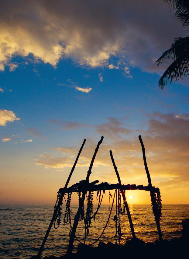
Altars (called lele ho‘okau), such as this one at the Ku‘emanu Heiau, are still used by some for prayer or meditation.
Altars (called lele ho‘okau), such as this one at the Ku‘emanu Heiau, are still used by some for prayer or meditation.
Published by Wizard Publications, Inc.
Post Office Box 991
Lihu‘e, Hawai‘i 96766–0991
© Copyright 2026 Andrew Doughty. All rights reserved.
ISBN: 978-1-949678-26-0 1065
Library of Congress Control Number 2024925660
Printed in China
Cover space imagery courtesy of Earthstar Geographics (terracolor.net). Cartography by Andrew Doughty.
All artwork and illustrations by Andrew Doughty and Lisa Pollak.
Past and present lava flow information for maps was graciously provided by an overworked and under-appreciated United States Geological Survey, the silent partner to all mapmakers. Keep up the good work!
We welcome any comments, questions, criticisms or contributions you may have and have incorporated some of your suggestions into this edition. Please send to the address above, or email us at information@revealedtravelguides.com.
Check out our website at RevealedTravelGuides.com for up-to-the-minute changes. Find us on Facebook, YouTube and Instagram.
All rights reserved. No part of this book may be translated or reproduced in any form, except brief extracts by a reviewer for the purpose of a review, without the prior written permission of Wizard Publications, Inc.
Although the author and publisher have made every effort to ensure that the information was correct at press time, the authors and publisher do not assume and hereby disclaim any liability to any party for any loss or damage caused by errors or omissions, whether such errors or omissions result from negligence, accident or any other cause. Information has been obtained from sources believed to be reliable, but its accuracy and completeness, and the opinions based thereon, are not guaranteed.


252 Island Dining Index
Dining Regions
Island Fish & Seafood 256 Lu‘au Foods 257 Other Island Foods 258 Kailua-Kona Dining
Kohala Dining
Hamakua & Waimea Dining 280 Hilo & Puna Dining
286 Dining Near Kilauea Volcano 287 South Island Dining
Island Nightlife
Surfing & Board Sports
Ziplines

235 Manta Ray Night Dive
Mauna Ulu Crater Hike
238 Marathon Snorkel to Papawai Bay
239 Jump Off the End of the World
240 Close Encounters With Dolphins 243 Rappel Off a 128-Foot Waterfall
244 Explore Untamed Lava Tubes
245 Boulder-hop to a Waterfall
247 Pedal Through Big Island’s Backcountry
248 Command Your Own Boat 249 Spearfishing 250 Hike to Flowing Lava
Lu‘au 292 Cocktail & Dinner Cruises

The Big Island has it all. Nowhere else in the world will you find the diversity available here. Pristine rain forests, lava deserts, world-class beaches, snow-covered mountains, an active volcano, dazzling sunsets and just about every activity you can think of. The island is huge— about the size of Connecticut. Navigating your way through this maze of opportunity can be daunting.
Most travel publishers send a writer or writers to a given location for a few weeks to become “experts” and to compile information for guidebooks. To our knowledge, we at Revealed Travel Guides are the only ones who actually live our books.
We hike the trails, ride the boats, eat in the restaurants, explore the reefs and do the things we write about. It takes us two years, full time, to do a first edition book, and we visit places anonymously. We marvel at writers who can do it all in a couple of weeks staying in a hotel. Wow, they must be really fast. Our method, though it takes much longer, gives us the ability to tell it like it is in a way no one else can. We put in many long hours, and doing all these activities is a burdensome grind. But we do it all for you—only for you. (Feel free to gag at this point.) We have found many special places that people born and raised here didn’t even know about because that’s all we do—explore the island.
We produce brand new editions of our books every year or two, but in the intervening time we constantly incorporate changes into the text nearly every time we do a new printing. We also post major changes on our website and all changes in our Revealed Travel Guides app. This allows us to make some modifications throughout the life of each edition.
In this day of easy-to-access online reviews from countless sources, you can get “ratings” for nearly every company out there. What you get from our reviews is a single source, beholden to none, and
with a comprehensive exposure to all of the companies. There are two critical shortcomings to online reviews. One is that you don’t know the source or agenda of the reviewer. Nearly every company that offers a service to the public thinks they are doing a good job. (But as you know, not everyone does.) So who can blame a company for trying to rig the system by seeding good reviews of their company at every opportunity or having friends write good reviews? Many also encourage satisfied customers to write favorable online reviews (obviously not encouraging unhappy customers to do so). But maybe their enemies or competitors retaliate with bad reviews. The point is, you never really know where those reviews come from, and it’s almost impossible to reconcile terrible reviews right next to glowing ones for the same company. Which do you believe?
The other problem is a lack of a frame of reference. A visitor to Hawai‘i goes on a snorkel boat and has a great time. (Hey, he snorkeled in Hawai‘i, swam with a turtle—cool!) When he goes back home, he posts good reviews all around. That’s great. But the problem is, he only went on one snorkel boat. We do ’em all. If only he’d known that another company he didn’t even know about did a much better job, had way better food, and a much nicer boat for the same price.
We are also blessed with hundreds of thousands of readers—from our books as well as our smartphone app—who alert us to issues with companies and places. Every single message from our readers is received, placed in a special database that we constantly have available while we’re out and about, and we personally follow up on every observation made by our readers. So when we walk into a business or restaurant, we check to see what our readers say and tips they send us, and we use them to our advantage. (Thanks for the head’s up about that in-

credible coconut cake at so-and-so restaurant—I know what I’ll be ordering for dessert today.) With such a resource, and after decades reviewing companies in Hawai‘i full time, there ain’t much that’s gonna get past us.
A quick look at this book will reveal features never before used in other guidebooks. Let’s start with the maps. They are more detailed than any other maps you’ll find, and yet they omit extraneous information that can sometimes make map reading a chore. We know that people in unfamiliar territory sometimes have a hard time determining where they are on a map, so we include landmarks. Most notable among these are mile markers. At every mile on main roads, the government has erected numbered markers to tell you where you are. Where needed, we’ve drawn legal public beach access in yellow, so you’ll know when you’re legally entitled to cross someone’s land. Most guidebooks have the infuriating habit of mentioning a particular place or sight but then fail to mention how to get there! You won’t find that in our book. We tell you exactly how to find the hidden gems and use our own special maps to guide you.
As you read this book, you will also notice that we are very candid in assessing businesses. Unlike some other guidebooks that send out questionnaires asking a business if they are any good (gee, they all say they’re good), we’ve had personal contact with the businesses listed in this book. One of the dirty little secrets about guidebook writers is that they sometimes make cozy little deals for good reviews. Well, you won’t find that here. We accept no payment for our reviews, we make no deals with businesses for saying nice things, and there are no advertisements in our book. What we’ve seen and experienced is what you get. If we gush over a certain company, it comes from personal ex-
perience. If we rail against a business, it is for the same reason. All businesses mentioned in this book are here by our choosing. None has had any input into what we say, and we have not received a single cent from any of them for their inclusion. (In fact, there are some who would probably pay to be left out, given our comments.) We always review businesses as anonymous visitors and only later as guidebook writers if we need more information. This ensures that we are treated the same as you. (Amazingly, most travel writers announce themselves.) What you get is our opinion on how they operate. Nothing more, nothing less.
Sometimes our candor gets us into trouble. More than once we’ve had our books pulled from shelves because our comments hit a little too close to home. That’s OK, because we don’t work for the people who sell the book; we work for the people who read the book. It’s also true that a handful of local residents have become upset because we’ve told readers about places that they’d rather keep for themselves. Ironically, it’s usually not people born and raised here who have this selfish attitude, but rather the newcomers who have read about these places in our book (of all things), then adopted the I’m here now—close the door mentality.
This book is intended to bring you independence in exploring the Big Island. We don’t want to waste any of your precious time by giving you bad advice or bad directions. We want you to experience the best that the island has to offer. Our objective in writing this book is to give you the tools and information necessary to have the greatest Hawaiian experience possible.
We hope we succeeded.
Andrew Doughty Kailua-Kona, Hawai‘i

As with people, volcanic islands have a life cycle. They emerge from their sea floor womb to be greeted by the warmth of the sun. They grow, mature and eventually die before sinking forever beneath the sea.
Sometime around 70 million years ago a cataclysmic rupture occurred in the Earth’s mantle, deep below the crust. A hot spot of liquid rock blasted through the Pacific plate like a giant cutting torch, forcing magma to the surface off the coast of Russia, forming the Emperor Seamounts. As the tectonic plate moved slowly over this hot spot, this torch cut a long scar along the plate, piling up mountains of rock, producing island after island. The oldest of these islands to have survived is

Kure. Once a massive island with its own unique eco-system, only its ghost remains in the form of a fringing coral reef, called an atoll.
As soon as the islands were born, a conspiracy of elements proceeded to dismantle them. Ocean waves unmercifully battered the fragile and fractured rock. Abundant rain, especially on the northeastern sides of the mountains, easily carved up the rock surface, seeking faults in the rock and forming rivers and streams. In forming these channels, the water carried away the rock and soil, robbing the islands of their very essence. Additionally, the weight of the islands ensured their doom. Lava flows on top of other lava, and the union of these flows is always weak. This lava also contains countless air pockets and is criss-crossed with hollow lava tubes, mak-

ing it inherently unstable. As these massive amounts of rock accumulated, their bases were crushed under the weight of subsequent lava flows, causing their summits to sink back into the sea.
What we call the Hawaiian Islands are simply the latest creations from this island-making machine. Someday they will disappear, existing as nothing more than footnotes in the Earth’s turbulent geologic history.
Kaua‘i and Ni‘ihau are the oldest of the eight major islands. Lush and deeply eroded, the last of Kaua‘i’s fires died with its volcano a million years ago. O‘ahu, Moloka‘i, Lana‘i, Kaho‘olawe—their growing days are over as well. Maui is in its twilight days as a growing island. After growing vigorously, Hawaiian volcanoes usually go to sleep for a million years or so before sputtering back to life for one last fling. Maui’s volcano Haleakala has entered its final stage and last erupted around 1790.
The latest and newest star in this island chain is Hawai‘i. Born less than a million years ago, this youngster is still vigorously growing. Though none of its five volcano mountains is considered truly dead, these days Mauna Loa and Kilauea are doing most of the work of making the Big Island bigger. Mauna Loa, the most massive mountain on Earth, consists of 10,000 cubic miles of rock. Quieter of the two active volcanoes, it last erupted in 1984. Kilauea is the most boisterous of the volcanoes and is the most active volcano on the planet. Kilauea’s recent eruptions ran from 1983 until 2018, along with a couple of brief hiccups in 2021 and 2022. The most recent eruption began just before Christmas in 2024 and, despite a few pauses, was still ongoing at press time. Up and coming onto the world stage is Kama‘ehuakanaloa. This new volcano is still 3,200 feet below the ocean’s surface, 20 miles off the southeastern coast of the island. Yet in a geologic


richer with its ascension, sometime in the next 100,000 years.
These virgin islands were barren at birth. Consisting only of volcanic rock, the first life forms to appreciate these new islands were marine creatures. Fish, mammals and microscopic animals discovered this new underwater haven and made homes for themselves. Coral polyps attached themselves to the lava rock and succeeding generations built upon these, creating what would become a coral reef.
Meanwhile, on land, seeds carried by the winds were struggling to colonize the rocky land, eking out a living and breaking down the lava rock. Storms brought the occasional bird, hopelessly blown off course. The lucky ones found the islands. The even luckier ones arrived with mates or had fertilized eggs when they got here. Other animals, stranded on a piece of floating debris, washed ashore against all odds and went on to colonize the islands. These introductions of new species were rare events. It took an extraordinary set of circumstances for a new species to actually make it to the islands. Single specimens were des-
tude. On average, a new species was successfully deposited here only once every 20,000 years.
When a volcanic island is old, it is a sandy sliver, devoid of mountains. When it’s middle-aged, it can be a lush wonderland, a haven for anything green, like Kaua‘i. And when it is young, it is dynamic and unpredictable, like the Big Island of Hawai‘i. Of all the Hawaiian Islands, none offers a larger range of climates and landscapes than the Big Island. The first people to discover Hawai‘i’s treasures must have been humbled at their good fortune.
Sometime around the fifth century A.D. a large, double-hulled voyaging canoe, held together with flexible sennit lashings and propelled by sails made of woven pandanus, slid onto the sand on the Big Island of Hawai‘i. These first intrepid adventurers, only a few dozen or so, encountered an island chain of unimaginable beauty.
They had left their home in the Marquesas Islands, 2,500 miles away, for reasons we will never know. Though some
The ancient Polynesians were exceptional navigators. These stones, at the navigational heiau near Mahukona, were aligned to point the way to other Hawaiian islands, Tahiti and other far away places.

say it was because of war, overpopulation or drought, it was more likely part of a purposeful exploration from a culture that had mastered the art of making their way through the featureless seas using celestial navigation and reading subtle signs in the ocean. Their navigational abilities far exceeded all the other “advanced” societies of the time. Whatever their reasons, these initial settlers took a big chance and surely must have been highly motivated. They could not have known that there were islands in these waters since Hawai‘i is the most isolated island chain in the world. (Though some speculate that they were led here by the golden plover—see facing page.)
Those settlers who did arrive brought with them food staples from home: taro, breadfruit, pigs, dogs and several types of fowl. This was a pivotal decision. These first settlers found a land that contained almost no edible plants. With no land mammals other than the Hawaiian bat, the first settlers subsisted on fish until their crops matured. From then on, they lived on fish and taro. Although many associate throw-net fishing with Hawai‘i,
this practice was introduced by Japanese immigrants much later. The ancient Hawaiians used fishhooks and spears, for the most part, or drove fish into a net already placed in the water. They also had domesticated animals, which were used as ritual foods or reserved for chiefs.
Little is known about the initial culture. Archaeologists believe that a second wave of colonists, probably from Tahiti, may have subdued these initial inhabitants around 1000 A.D. Some may have resisted and fled into the forest, creating the legend of the Menehune.
Today, Menehune are always referred to as being small in stature. Initially referring to their social status, the legend evolved to mean that they were physically short and lived in the woods away from the Hawaiians. (The Hawaiians avoided the woods when possible, fearing that they held evil spirits, and instead stayed on the coastal plains.) The Menehune were purported to build fabulous structures, always in one night. Their numbers were said to be vast, as many as 500,000. It is interesting to note that in a census taken of Kaua‘i around 1800, 65 people
from a remote valley identified themselves as Menehune.
The second wave probably swept over the island from the south, pushing the first inhabitants ever-north. On a tiny island north of Kaua‘i, archeologists have found carvings, clearly not Hawaiian, that closely resemble Marquesan carvings, probably left by the doomed exiles.
This second culture was far more aggressive and developed into a highly classconscious society. The culture was governed by chiefs, called Ali‘i, who established a long list of taboos called kapu. These kapu were designed to keep order, and the penalty for breaking one was usually death by strangulation, club or fire. If the violation was serious enough, the guilty party’s entire family might also be killed. It was kapu, for instance, for your shadow to fall across the shadow of the ali‘i. It was kapu to interrupt the chief if he was speaking. It was kapu to prepare men’s food in the same container used for women’s food. It was kapu for women to eat pork or bananas. It was kapu for men and women to eat together. It was kapu not to observe the days designated to the gods. Certain areas were kapu for fishing if they became depleted, allowing the area to replenish itself.
While harsh by our standards today, this system kept the order. Most ali‘i were sensitive to the disturbance their presence caused and often ventured outside only at night, or a scout was sent ahead to warn people that an ali‘i was on his way. All commoners were required to pay tribute to the ali‘i in the form of food and other items. Human sacrifices were common, and war among rival chiefs the norm.
By the 1700s, the Hawaiians had lost all contact with Tahiti, and the Tahitians had lost all memory of Hawai‘i. Hawaiian
canoes had evolved into fishing, and interisland canoes and were no longer capable of long ocean voyages. The Hawaiians had forgotten how to explore the world.
In January 1778 an event occurred that would forever change Hawai‘i. Captain James Cook, who usually had a genius for


Given the remoteness of the Hawaiian Islands relative to the rest of Polynesia (or anywhere else for that matter), you’ll be forgiven for wondering how the first settlers found these islands in the first place. Many scientists think it might have been this little guy here. Called the kolea, or golden plover, this tiny bird flies over 2,500 miles nonstop to Alaska every year for the summer, returning to Hawai‘i after mating. Some of these birds continue past Hawai‘i and fly another 2,500 miles to Samoa and other South Pacific islands. The early Polynesians surely must have noticed this commute and concluded that there must be land in the direction that the bird was heading. They never would have dreamed that the birds leaving the South Pacific were heading to a land 5,000 miles away, and that Hawai‘i was merely a stop in between, where the lazier birds wintered.
predicting where to find islands, stumbled upon Hawai‘i. He had not expected the islands to be here. He was on his way to Alaska on his third great voyage of discovery, this time to search for the Northwest Passage linking the Atlantic and Pacific oceans. Cook approached the shores of Waimea, Kaua‘i, at night on Jan. 19, 1778. The next morning Kaua‘i’s inhabitants awoke to a wondrous sight and thought they were being visited by gods. Rushing out to greet their visitors, the Kauaians were fascinated by what they saw: pointyheaded beings (the British wore tri-cornered hats) breathing fire (smoking pipes) and possessing a death-dealing instrument identified as a water squirter (guns). The amount of iron on the ship was incredible. (They had seen iron before in the form of nails on driftwood but never knew where it originated.)
Cook left Kaua‘i and briefly explored Ni‘ihau before heading north for his mission on Feb. 2, 1778. When Cook returned to the islands in November after failing to find the Northwest Passage, he visited the Big Island of Hawai‘i.
It’s hard to believe that the Big Island will eventually look like this oldest Hawaiian island, Kure Atoll. One day its last ghostly remains will sink forever beneath the sea.

The Hawaiians had probably seen white men before. Local legend indicates that strange white people washed ashore at Ke‘ei Beach sometime around the 1520s and integrated into society. This coincides with Spanish records of two ships lost in this part of the world in 1528. But a few weird-looking stragglers couldn’t compare to the arrival of Cook’s great ships and instruments.
Despite some recent rewriting of history, all evidence indicates that Cook, unlike some other exploring sea captains of his era, was a thoroughly decent man. Individuals need to be evaluated in the context of their time. Cook knew that his mere presence would have a profound impact on the cultures he encountered, but he also knew that change for these cultures was inevitable, with or without him. He tried, unsuccessfully, to keep the men known to be infected with venereal diseases from mixing with local women, and he frequently flogged infected men who tried to sneak ashore at night. He was greatly distressed when a party he sent to Ni‘ihau was forced to stay overnight due to high surf, knowing that his men might transmit diseases to the women (which they did).
Cook arrived on the Big Island at a time of much upheaval. The mo‘i, or king, of the Big Island had been badly spanked during an earlier attempt to invade Maui and was now looting and raising hell throughout the islands as retribution. Cook’s arrival and his physical appearance (he stood 6 feet, 4 inches) led the Hawaiians to assume that he was the god Lono, who was responsible for fertility of the land. Every year the ruling chiefs and their war god Ku went into abeyance, removing their power so that Lono could return to the land and make it fertile again, bringing back the spring rains. During this time all public works stopped
At the south end of Alii Drive in Kona, when you’ve passed the last resort, there is a lava road leading toward the ocean. This field of lava and an area around the point called Kuamo‘o have an extraordinary past. Here occurred an event that forever changed a people. For it was here that the Hawaiians abolished their ancient religion one day in 1820.
The Hawaiian religion was based on the kapu system. A myriad of laws were maintained, with death being the usual punishment for violation. The Hawaiians believed that rigid enforcement for a single violation was necessary, or else the gods would punish the whole community in the form of earthquakes, tsunamis, lava flows and famine. When Captain Cook came, he and his men were unaware of the many laws and inadvertently violated many of them. When natural punishments failed to materialize, many Hawaiians concluded that the gods would not enforce the laws. Since many found the kapu laws burdensome and oppressive, there was pressure to abolish them. While King Kamehameha I was alive, however, none dared challenge the kapu system. Almost as soon as he died, King Kamehameha II, pressured by his stepmother Ka‘ahumanu, decided to put an end to the kapu system and destroy the temples around the island. This was before any missionaries ever came to these islands.
It was decided that the action would be consecrated by the simple act of having the king eat with women in public in November 1819. This had heretofore been kapu, and the penalty for breaking this law was death. In breaking this kapu in public, Kamehameha II declared an end to the old ways. One of his cousins, Kekuaokalani, was to be king of the spiritual world and challenged Kamehameha. The ferocious battle took place near here in early 1820. His cousin was hit by Kamehameha II’s forces, and the man’s grieving wife ran to his side as he fell. She cried out, begging that her wounded husband’s life be spared. Instead she and her husband were summarily executed on the spot, with her body falling on top of his. The Hawaiian religion, as a dominant force, died with them on that bloody day. If you look to the south, you can see what look like terraces cut into the side of the mountain. These are the graves of the many hundreds who died in that very battle. Today there is a resurgence of the Hawaiian religion. Hawaiians are grappling with their role in the world and are reaching back to their roots. The religion that seemingly died on that raw lava field is being reborn in the hearts of some contemporary Hawaiians.

and the land was left alone. At the end of this Makahiki season, people would again seize the land from Lono to grow crops and otherwise make a living upon it. Cook arrived at the beginning of the Makahiki, and the Hawaiians naturally
thought he was the god Lono, coming to make the land fertile. Cook even sailed into Kealakekua Bay, exactly where legend said Lono would arrive.
The Hawaiians went to great lengths to please their “god.” All manner of supplies
were made available. Eventually, they became suspicious of the visitors. If they were gods, why did they accept Hawaiian women? And if they were gods, why did one of them die?
Cook left at the right time. The British had used up the Hawaiians’ hospitality (not to mention their supplies). But shortly after leaving the Big Island, the ship broke a mast, making it necessary to return to Kealakekua Bay for repairs. As they sailed back into the bay, the Hawaiians were nowhere to be seen. A chief had declared the area kapu to help replenish it. When Cook finally found the Hawaiians, they were polite but wary. Why are you back? Didn’t we please you enough already? What do you want now?
As repair of the mast went along, things began to get tense. Eventually the Hawaiians stole a British rowboat (for the nails), and the normally calm Cook blew his cork. On the morning of Feb. 14, 1779, he went ashore to trick the chief into coming aboard his ship where he would detain him until the rowboat was returned. As Cook and the chief were heading to the water, the chief’s wife begged the chief not to go. By now tens of thousands of Hawaiians were crowding around Cook, and he ordered a retreat. A shot was heard from the other side of the bay, and someone shouted that the Englishmen had killed an important chief. A shielded warrior with a dagger came at Cook, who fired his pistol (loaded with non-lethal small shot). The shield stopped the small shot, and the Hawaiians were emboldened. Other shots were fired. Standing in knee-deep water, Cook turned to call for a ceasefire and was struck in the head from behind with a club, then stabbed. Dozens of other Hawaiians pounced on him, stabbing his body repeatedly. The greatest
explorer the world had ever known was dead at age 50 in a petty skirmish over a stolen rowboat.
When things calmed down, the Hawaiians were horrified that they had killed a man they had earlier presumed to be a god. See what finally happened to Cook’s body on page 76.
The most powerful and influential king in Hawaiian history lived during the time of Captain Cook and was born on this island sometime around 1758. Until his rule, the Hawaiian chain had never been ruled by a single person. He was the first to “unite” (i.e., conquer) all the islands.
Kamehameha was an extraordinary man by any standard. He possessed herculean strength, a brilliant mind and boundless ambition. He was marked for death before he was even born. When Kamehameha’s mother was pregnant with him, she developed a strange and overpowering craving—she wanted to eat the eyeball of a chief. The king of the Big Island, mindful of the rumor that the unborn child’s real father was his bitter enemy, the king of Maui, asked his advisors to interpret. Their conclusion was unanimous: The child would grow to be a rebel, a killer of chiefs. The king decided that the child must die as soon as he was born, but the baby was instead whisked away to a remote valley on the northeast coast to be raised.
In ancient Hawaiian society, your role in life was governed by the class you were born into. The Hawaiians believed that breeding among family members produced superior offspring (except for the genetic misfortunates who were killed at birth), and the highest chiefs came from brother/sister combinations. Kamehameha was not of the highest class (his parents

The Hawaiians built a highly structured society around the needs, desires and demands of their gods. This place of refuge is called Pu‘uhonua o Honaunau.
were merely cousins), so his future as a chief would not come easily.
As a young man, Kamehameha was impressed by his experience with Captain Cook. He was among the small group that stayed overnight on Cook’s ship during Cook’s first pass of Maui. (Kamehameha was on Maui valiantly fighting a battle in which his side was getting badly whupped.) Kamehameha recognized that his world had forever changed, and he shrewdly used the knowledge and technology of westerners to his own advantage.
Kamehameha participated in numerous battles. Many of them were lost (by his side), but he learned from his mistakes and developed into a cunning tactician. When he finally consolidated his rule over the Big Island (by luring his enemy to be the inaugural sacrifice at the Pu‘ukohola Heiau near Kawaihae), he fixed his sights on the entire chain. In 1795 his
large company of troops, armed with some western armaments and advisers, swept across Maui, Moloka‘i, Lana‘i and O‘ahu. After some delays with the last of the holdouts, Kaua‘i, their king finally acquiesced to the inevitable, and Kamehameha became the first ruler of all the islands. He spent his final years governing the islands peacefully from his capital at Kailua Bay and died in 1819.
During the 19th century, Hawai‘i’s character changed dramatically. Businessmen from all over the world came here to exploit Hawai‘i’s sandalwood, whales, land and people. Hawai‘i’s leaders, for their part, actively participated in these ventures and took a piece of much of the action for themselves. Workers were brought in from many parts of the world, changing the racial makeup of the islands. Gov-

ernment corruption became the order of the day, and everyone seemed to be profiting, except the Hawaiian commoner. By the time Queen Lili‘uokalani was overthrown by a group of American businessmen in 1893, Hawai‘i had become directionless, barely resembling the Hawai‘i Captain Cook had encountered the previous century. The kapu system had been abolished by the Hawaiians shortly after the death of Kamehameha the Great. The “Great Mahele,” begun in 1848, had changed the relationship Hawaiians had with the land. Large tracts of land were sold by the Hawaiian government to royalty, government officials, commoners and foreigners, effectively stripping many Hawaiians of the land they had lived on for generations.
The United States recognized the Republic of Hawai‘i in 1894 with Sanford Dole as its president. It was later annexed and became an official territory in 1900. During the 19th and 20th centuries, sugar established itself as king. Pineapple was also a major crop in the islands, with the island of Lana‘i purchased in its entirety for the purpose of growing pineapples. As the 20th century rolled on, Hawaiian sugar and pineapple workers found themselves in a lofty position—they became the highest paid workers for these crops in the world. As land prices rose and competition from other parts of the world increased, sugar and pineapple became less and less profitable. Today, these crops no longer hold the position they once had. The “pineapple island” of Lana‘i has shifted away from pineapple growing and focuses on luxury tourism, with software mogul Larry Ellison buying the island in 2012. The sugar industry is now dead in Hawai‘i, and sugar lands are being converted to other purposes while the workers move into other vocations, often tourist-related.
The story of Hawai‘i is not a story of good versus evil. Nearly everyone shares in the blame for what happened to the Hawaiian people and their culture. Westerners certainly saw Hawai‘i as a potential bonanza and easily exploitable. They knew what buttons to push and pushed them well. But the Hawaiians, for their part, were in a state of flux. The mere appearance of westerners seemed to reveal a discontent, or at least a weakness, in their system that had been lingering just below the surface. In fact, in 1794, a mere 16 years after first encountering westerners and under no military duress from the West, Kamehameha the Great volunteered to cede his island over to Great Britain. He was hungry for western arms so he could defeat his neighbor island opponents. He even declared that, as of that day, they were no longer people of Hawai‘i, but rather people of Britain. (Britain declined the offer.) And in 1819, immediately after the death of the strong-willed Kamehameha, the Hawaiians, of their own accord, overthrew their own religion, dumped the kapu system and denied their gods. This was before any western missionaries ever came to Hawai‘i.
Nonetheless, Hawai‘i today is once again seeking guidance from its heritage. The echoes of the past seem to be getting louder with time, rather than diminishing. Interest in the Hawaiian language and culture is at a level not seen in many decades. All who live here are very aware of the issues and the complexities involved, but there is little agreement about where it will lead. As a result, you will be exposed to a more “Hawaiian” Hawai‘i than those who might have visited the state a generation ago. This is an interesting time in Hawai‘i. Enjoy it as observers, and savor the flavor of Hawai‘i.

In order to get to the islands, you’ve got to fly here. While this may sound painfully obvious, many people contemplate cruises to the islands. Remember, there isn’t a single spec of land between the west coast and Hawai‘i. And 2,500 miles of open water is a pretty monotonous stretch to cover.
When planning your trip, a travel agent used to be helpful, though that method has become less and less common. Most online travel agents (OTAs) have consolidated into a couple of big players, but it is worth your time to poke around a bit. If you don’t want to go through these sources, there are large wholesalers that can get you airfare, hotel and a rental car, often cheaper than you can get airfare on your own. Pleasant Holidays (800-742-9244) is one of the more well-known providers
of complete package tours. They are renowned for their impossibly low rates. We’ve always been amazed that you can sometimes get round trip airfare from the mainland, a hotel, and car for a week for as low as $1,300 per person, depending on where you fly from, when you fly and where you stay. That’s a small price to pay for your little piece of paradise.
If you arrange airline tickets and hotel reservations yourself, you can often count on paying top dollar for each facet of your trip. The prices listed in the free Hotels section of our Revealed Travel Guides app (and on our website) reflect the average rates, meaning the published rates before any discounts. Rates can be significantly lower if you go through a wholesaler.
When you pick your travel source, shop around—the differences can be dramatic. A good source can make the difference between affording a one-week vacation and

a two-week vacation. It’s not always a straightforward process; there is an art to it.
Flight schedules change all the time, but United and others often have direct flights to Kona from the mainland. Not having to cool your heels while changing planes on O‘ahu is a big plus because interisland flights aren’t quite as simple and painless as they used to be. Flight attendants zip up and down the aisles hurling juice at you for the short, interisland flight. If you fly to Kona from Honolulu, sit on the left side (seats with an “A”) coming in (right side going out) for superb views of several other islands. If you fly into Hilo, sit on the right side coming in. When flying to O‘ahu from the mainland, seats on the left side have the best views. Interisland flights are done by Southwest (800-435-9792), Hawaiian (800-367-5320) and Mokulele (866-260-7070). We prefer Mokulele when possible because their smaller planes leave out of the commuter terminal in Kona, avoiding TSA and the rest of the airport system. Arrive 30 minutes early instead of 90.
This list may assist you in planning what to bring. Obviously you won’t bring everything on the list, but it might make you think of a few things you may otherwise overlook:
• Water-resistant, reef-safe sunscreen with an SPF 30 or higher. Make sure the ingredients are zinc oxide and/or titanium dioxide. The higher the percentage, the better.
• Rash guard, or other quick drying cover-up for sun protection
• Two bathing suits
• Shorts and other cool clothing
• Polarized sunglasses (you’ll see much more in the ocean)
• Hiking sticks (carbide-tipped ones are good for boulder-hopping hikes)
• Shoes—flip-flops, trashable sneakers, water shoes, hiking shoes
• Hat or cap for sun protection
• Mask, snorkel and fins
• Camera with lots of memory
• Waterproof case for phone
• Warm clothes (for Mauna Kea or other high-altitude activities) and junk clothes for hikes, etc.
• Light rain jacket
• Small flashlight, if you like caves or for the lava field at night if there’s a surface flow
• Cheap, simple backpack—you don’t need to go backpacking to use one; a 10-minute trek to a secluded waterfall is much easier if you bring a pack
• Mosquito repellent for some hikes (lotions with at least 10% DEET seem to work best)
Rental car prices in Hawai‘i have traditionally been cheaper than almost anywhere else in the country, and the competition is ferocious. Nearly every visitor to the Big Island gets around in a rental car, and for good reason—it’s a big island. Fortunately, none have mileage charges. Don’t forget to check Turo.com for car sharing from a basic island car to an exotic one.
This seems like a good place to mention that Uber and Lyft both have a presence on the island.
At Kona Airport, rental cars are a shuttle bus ride away. It’s a good idea to reserve your car in advance since companies can run out of cars during peak times.
Many hotels, condos and rental agents offer excellent room/car packages. Find out from your hotel or travel agent if one is available. You can rent a car in Hilo and return it to Kona (or vice versa). There’s usually an extra fee of about $50–$100 (depending on the company and car). And prices overall are usually much higher in Hilo than in Kona.
Below is a list of rental car companies. Some have desks at various hotels.

Alamo—(877) 222-9075
Kona: (808) 329-8896
Hilo: (808) 961-3343
Avis—(800) 321-3712
Kona: (808) 327-3000
Hilo: (808) 935-1298
Budget—(800) 527-0700
Kona: (808) 329-8511
Hilo: (808) 935-6878
Discount Hawaii Car Rental— (800) 292-1930
Dollar—(800) 800-4000
Kona & Hilo: (866) 434-2226
Enterprise—(800) 261-7331
Kona: (808) 334-1810
Hilo: (808) 933-9683
Hertz—(800) 654-3131
Kona: (808) 329-3566
Hilo: (808) 935-2898
National—(877) 222-9058
Kona: (808) 327-3755
Hilo: (808) 935-0891
Thirfty—(800) 367-5238
Kona & Hilo: (877) 283-0898
If you’re 21–24 years old, most of the companies will rent to you, but you’ll pay about $25 extra per day for the crime of being young and reckless. Try Discount Hawaii Car Rental first. If you’re under 21, rent a bike or moped or take the bus.
We strongly believe that the best vehicle for the island is a four-wheel drive. They come closed (SUV) or open (like a Wrangler). They are more expensive, but there are several roads, beaches and sights that you can’t visit without 4WD. Unpaved roads are contractually off limits with most of the rental car companies. That means that if you drive one, the insurance you take out with the rental company is void, so you or your insurance company back home would have to eat it. Different companies have different restrictions, but from a practical standpoint, 4WD is the way to go. The drawbacks to open Jeeps are more wind and heat and no trunk. Closed 4WDs are best. Expect to pay up to $80–$100 or more per day for the privilege of cheating the road builders.
If you really want to ham it up, you can try renting a HOG. (Disclaimer—Revealed Travel Guides will not be held liable for bad puns.) Riders-share.com is where locals list their bikes for rent. Prices vary widely (so does your selection), but we’ve found that you can find Harleys available here and prices for any motorcycle can be quite
If a hike or 4WD to Makalawena Beach doesn’t sound appealing, you can always kayak to it.

reasonable. Kona Scooter Rental (808-5184100) in Kona has a Harley for about $250 for 24 hours and scooters for $80–$105 for 24 hours. (Scooters are only useful around Kailua town.) If you want to add a wheel, Aloha Motorsports (808-6677000) in Waikoloa rents Polaris Slingshots (those sporty, three-wheeled roadsters you see zipping around) for a just-hurt-me price of $249 for 4 hours. The hourly prices go down the longer you book them for.
Gasoline is obscenely expensive here. You may want to have some FedExed to you from home to save money. (OK, maybe not that expensive.) Kona is said to have among the highest gas prices in the United States (about 15 cents higher than expensive Hilo). Whether that’s true or not, prepare to get hammered at the pump. If you’re in the Kohala resort area, there’s a station off the road to the Waikoloa Resorts at mile marker 76. The cheapest gas on the east side of the island is in Hilo or Pahoa, south of Hilo. The cheapest on the whole island is in Kona at Costco (but you have to be a Costco member). It’s marked on the map on page 168 and not far from the Kona Airport. Many companies charge a top-off fee due to the airport’s distance to town, so fill it to the top. And make sure you check your receipt. On many occasions we’ve topped off the tank to the brim, only to find a $20 “fuel charge” tacked onto our final tab.
Seat belt and child restraint use is required by law, and the police will pull you over for this alone. Wide open roads and frequently changing speed limits make it easy to accidentally speed here. Police usually cruise in their own private, unmarked vehicles with a small blue light on top, so you might not see them coming. And we’ve noticed a huge increase in the number of speed traps on the island in recent years. We strongly recommend using cruise control and paying attention to
changes in speed limits if you want to leave the island with the same driving score you arrived with.
Cell phone use is illegal for drivers unless you have a headset or wireless.
It’s best not to leave anything valuable in your car. There are teenagers here who pass the time by breaking into cars. Hapuna Beach and several Hilo waterfalls are notorious for car break-ins. When we park at a beach or waterfall, or any other place frequented by visitors, we take all valuables with us, leave the windows up, and leave the doors unlocked. (Just in case someone is curious enough about the inside to smash a window.) There are plenty of stories about someone walking 100 feet to a waterfall in Hilo, coming back to their car, and finding that their brand new iPad has walked away. And don’t be gullible enough to think that trunks are safe. Someone who sees you put something in your trunk can probably get at it faster than you can with your key.
Kailua-Kona possesses the dry town syndrome: At the first drop of rain, many Kona drivers become vehicularly uncoordinated, driving like a drunken cat on ice, so beware of this.
Traffic has increased a lot in the past few years and you should expect to get stuck in it, especially in Kona. Just remember that it could be worse—you could be in traffic back home and on your way to work
The Big Island is, to use the scientific term, one big bugga. With this in mind, we have decided to describe the various parts of the island in a series of tours. You’re not being pigeonholed into seeing the island in this order, but we had to organize the regions in some fashion, and this seemed the logical way to do it rather than a scattershot description. You can take these tours from any place you are staying, but we have described most of them (except the Hilo tour and the Hamakua/Waimea
2015 was a busy hurricane season, with three threatening Hawai‘i at one time, but none nailed us thanks to our normally occurring protective windshear.

tour) on the assumption that you are starting from the west (Kona) side because the majority of Big Island visitors do just that. The Hamakua/Waimea section is described from the Hilo side first because it’s convenient to see it that way after traveling via Saddle Road.
Nearly every guidebook divides the Big Island and its sights by districts. While this land division made perfect sense to the ancients who divvied up the island among themselves, it is not real helpful to the modern traveler who cruises the island by car. So we have divided the island up in a way that makes more sense to today’s visitor. It takes into account where most people stay and how they drive. Look at the inside back cover map to see how we have divided the island and on what pages we describe the sights.
Most main roads have mile markers erected every mile. Since Hawai‘i is mostly void of other identification signs, these little green signs can be a big help in knowing where you are at a given time. Therefore, we have placed them on the maps represented as a number inside a small box. We will often describe a certain feature or unmarked road as being “0.4 miles past mile marker 22.” We hope this helps.
For directions, locals usually describe things as being on the mauka (MOW-ka) side of the road—toward the mountains— or makai (ma-KIGH)—toward the ocean.
Our main island bus is called HeleOn (808-961-8744). It was designed for local use, so it doesn’t go to all the places that visitors want to go, but it’s free (until the end of 2025). However, it does go between Hilo and Kona, and they do take luggage. Passengers exiting at Hawai‘i Volcanoes National Park will have a $15 per pedestrian or bicycle entry fee to be paid by the passenger directly to the park. There are also bus tours from Roberts Hawai‘i (808-539-9400).
A beautiful beach at sunset—many couples dream of such a background for their special day. ‘Anaeho‘omalu Beach is one of the more popular spots for sunset weddings. The Big Island offers an almost unlimited selection of wedding, reception and honeymoon possibilities. Although you can set everything up yourself using the internet and email, it’s usually easier and sometimes less expensive to use a professional who can assist you.
This one’s hard for us. Unlike other activities in this book, we can’t exactly get married with all the companies and review them. (The flower bills alone would bankrupt us.) Almost all the major resorts have wedding coordinators who can offer help. And there are lots of private wedding coordinators. A good re-
280 Inches
240 Inches
200 Inches
160 Inches
120 Inches
80 Inches
60 Inches
40 Inches
30 Inches
20 Inches
10 Inches
source is weddingwire.com, a wedding network professional exchange.
Expect to pay around $500ish for a minimal wedding package (officiant, flower leis and license assistance). Resorts generally charge a hefty fee to use their grounds whether you are a guest or not. All beaches are public, so it won’t be a private ceremony. Consider renting a private home or an entire B&B in which to hold the ceremony and reception.
Contact the State Department of Health (808-586-4545) on the Big Island (or visit their website) to obtain an application or to get the names of license agents on the Big Island. Both parties must be at least 18. No residency or blood tests are required. The fee is $65, and the license is good for 30 days. Both parties must be present with photo IDs at the time of the appointment with the license agent.
The weather on the Big Island is more diverse than any island or other comparably sized chunk of land in the world.
You name it, we got it. According to the Köppen Climate Classification System (which is probably your favorite system, too, right?), the Big Island has 10 of the 15 types of climatic zones in the world. (Not climactic zones, which we accidentally printed in a previous guidebook. Boy, people were really anxious to find one of those!) Only Cold Continental Climate categories are absent. Here we’ve got tropical, monsoonal, desert and even periglacial climates, among others. So no matter what kind of weather you like, we are sure to have it here. As you ascend the slopes of the volcanoes, you lose about 3 °F for every thousand feet.
Kailua-Kona traditionally has had weather that can best be described as eternal springtime. Quite simply, it’s almost always warm and wonderful. The average high in February (the coldest month) is 81 °F and the low is 66 °F, whereas in August (the warmest month) the high is 87 °F and the low is 73 °F. Humidity is usually between 50% and 80%. The temperature change between night and day is greater than the temperature change between winter and summer, so it could easily be
said that nighttime is the winter of the Big Island. Balmy wraparound onshore breezes usually keep it comfortable. The exception is during Kona winds (so named because they come from the Kona direction, rather than out of the northeast as is usually the case). Kona winds occur about 5% of the time and bring stillness or warm air to Kona, creating uncomfortably humid conditions. Normal conditions in Kona and Kohala mean clear mornings with afternoon clouds created by thermal heating, so morning is usually better for activities such as air tours. During the summer, evening showers often occur as warm moist air is cooled, squeezing rain out of the humidity. Because it is totally protected from the trade winds by Hualalai, Kona is the only place in the state that gets most of its rainfall in the summer afternoons and evenings. The higher up the mountain, the more rain you get. Kona is occasionally ravaged by a nasty but natural pollutant called vog from Kilauea volcano (thanks to airflow patterns). Vog seems to affect people in different ways, but the most common symptoms are similar to seasonal allergies—itchy, watery eyes, throat irritation and headache.
Hilo’s weather is almost always described with one word—rain. Hilo is the wettest city in the United States. Annual rainfall is rarely less than 100 inches, usually much more. But rain is not a constant here. Hilo has times of drought like anywhere else. (Like when rainfall was a mere 70 inches one year, triggering rationing.) Most of the rain falls at night. When daytime showers do occur, they are often intense but short-lived. That said, rain or cloudiness will be a factor here. One of the reasons that Kailua-Kona is so much more popular than Hilo is that visitors like sunny weather, and Hilo can’t compete in that area. Also, all that rain has to go somewhere, which is why the ocean off Hilo is not nearly as clear as Kona’s runoff-free waters.
The Kohala resort area is the driest part of the island, with rainfall usually around 10 inches per year. Sunshine is almost assured (which is why it is so popular). The weather penalty here is the wind. As the lava fields heat up during the day, the air heats and rises. Air from the ocean rushes in to fill the void, creating strong afternoon convective breezes. The hotter, drier and sunnier it is that day, the breezier it may be that afternoon.
The general rule of thumb is that in wet areas like Hilo, most of the rain falls at night and early morning. Dry areas like Kona and Kohala get their rains in the late afternoon and early evenings.
Water temperatures range from 75 °F at its coldest in February to 82 °F at its warmest in September/October. It’s colder in some areas where freshwater springs percolate from the ocean’s floor and float to the top, forming a boundary called a Ghyben-Herzberg lens
Visitors are usually unprepared for the sheer size and diversity of the Big Island. The island is over 4,000 square miles, and a circular trip around, on Highways 19 and 11, is a hefty 222 miles. During that drive you pass through dozens of different terrains and climates. (And that doesn’t even include Saddle Road, Lower Puna, any of North Kohala or scores of other places.) Put simply, this island is too big and too diverse to try to see in a few days. The graphic on page 31 gives perspective.
If you are on the island for three days or less, we recommend that you don’t try to see the whole island; you’ll only end up touring Hawai‘i’s exotic blacktop. Pick a side. Since one of your days should be spent at the volcano, that leaves you with a scant two days to experience either Hilo’s and Puna’s beauty or the Kona side’s range of activities.
Deciding which side of the island to spend the most time on is a difficult deci-
sion, but the numbers are definitely skewed. Most visitors spend most of their time on the western, or Kona, side. There are several reasons for this:
The Kona side has the sunshine. The climate in Kona is as perfect as weather gets, and the Kohala resort area has the highest number of sunny days of anywhere in the state. The Kona side also has far more activities available. This leads to another reason—the ocean. Since it’s on the leeward side of the island, and because there are no permanent streams on the entire west side of the island (except for the one from Kona to Hilo that’s filled with tax money), Kona has the calmest, clearest water in the state. Water sports such as swimming, snorkeling, SCUBA, fishing—you name it—are usually unmatched on the Kona side. This side also has the best beaches on the island, with some, such as Hapuna, consistently rated in the top five in the United States. (With a few notable exceptions, the Hilo side has poor beaches.) All this adds up to a traveler’s delight, one of the reasons that the Kona side has such a high visitor repeat ratio. But stand by for a shock when you fly into Kona Airport for the first time. Kona makes a rotten first impression on the uninitiated airborne visitor. Part of the airport sits atop a lava flow from 1801,
and the first thing you think when you fly in over all that jet black lava is, “I came all this way for this?” Don’t worry; it gets much better.
On the other hand, the Kona side is short of what Hilo has in abundance— green. Whereas much of the Kona side is dominated by lava, Hilo is plant heaven. The weather usually comes from the northeast, so Hilo gets around 140 inches of rain per year. This is paradise for anything that grows. Hilo also has breathtaking waterfalls. You won’t find one on the Kona side unless it’s in the lobby of your hotel. Hilo’s weather has created beautiful folds and buckles in the terrain. The unweathered Kona side lacks angles—it’s mostly gentle slopes. Lastly, Hilo is much more convenient for exploring Kilauea volcano.
The schism between the two sides of the island is wide and deep. Because the two sides are so different and the distances so large (for Hawai‘i, that is), many people who live on the west side haven’t been to Hilo or Kilauea volcano in years. And lots of Hilo residents haven’t been to Kona in years. Both sides tend to playfully badmouth the other. The Kona side creates the tax base, and the Hilo side, the center of county government, spends it (often
Only on the Big Island can you experience both conditions on the same day a few dozen miles apart.

on Hilo-oriented infrastructure). Hilo has lots of roads that few drive, while Kona drivers curse the traffic on their limited number of roads.
If you have a week on the Big Island, you might want to spend four to five days on the Kona side and two to three days in Hilo or Puna. The volcano itself can take one to two days, and you’re better off exploring it from Hilo or Puna than from Kona. Hilo all but closes down on Sundays, with most business, even the few touristrelated ones, taking the day off.
Throughout our book we talk about the positives associated with the various areas. In deciding where to stay, here are three negatives for each major location worth considering:
Kohala—Food will cost you more and so will places to stay. You are far from the town of Kailua-Kona and its available resources. You are far from the volcano.
Kailua-Kona—Traffic, while not nearly as bad as the mainland, can be troublesome at commute time. There’s more noise along Alii Drive.
Hilo—Activities are less numerous. The ocean is less pleasant. Rain will probably be a companion. There are no megaresorts on this side of the island. Choices are fewer, but while the hotels were worn and dingy not that long ago, most have been renovated, and you finally have some good choices in Hilo.
Kohala is famous for its mega-resorts. These destination resort hotels have tons to see and do on the premises, pricey restaurants offering superb atmosphere and cuisine, and almost unending sunny weather. The developers have created oases in the lava desert where lava once stretched uninterrupted for miles.
You will notice that accommodation prices are high in Kohala. These snazzy resorts don’t come cheap. We leave it up to you to decide if it’s in your budget. A lot of them have Real Gem icons next to them. We like to think of ourselves as stingy with these, but facts are facts— these are gems. But like the genuine article, these gems come at a price.
Picking the best mega-resort in Kohala is not a straightforward process. All of them have radically different personalities, so your personality is key to which one you’ll like best. Most of these resorts do a great job at creating an atmosphere. The question is, is it your atmosphere? In our view, the Mauna Kea Resort has the best exotic tropical feel. The Fairmont Orchid has the richest, most luxurious feel. The Hilton Waikoloa Village has the most jaw-dropping, elaborate, yet family-oriented feel. And 10 miles south of the main Kohala resort area, The Four Seasons has some of both Mauna Kea’s and the Fairmont Orchid’s assets—rich and luxurious, yet also a great tropical feel. Most of these resorts are world class, and we don’t say that lightly. Choosing one just depends on what you want.
If it’s a cheap condo you’re looking for, go elsewhere. Kohala only has upscale condos for rent.
The resorts in Kailua-Kona and the surrounding area aren’t of the same caliber as the glitzy mega-resorts of Kohala, but neither are the prices. You’ll find that you can stay and eat in Kona a lot cheaper than Kohala. Condos are far more numerous here than hotels. Some condos are a downright bargain, while others can only be recommended to in-laws.
Most accommodations in Kailua-Kona are along Alii Drive. This road fronts the shoreline, offering splendid ocean locations and sunsets. The penalty for
staying on Alii Drive is auto noise. Cars and motorcycles scoot by, sometimes creating unpleasant reminders in some condos that you are still in the real world. (Other condos keep their rooms far enough from the road to keep them blissfully quiet.)
The high season in Kona is December through March, and most condos charge more at that time. Also, most condos have a minimum stay.
Your choices in Hilo are much more limited than on the western side of the island. The number of overnight visitors here is a fraction of what the Kona side gets. The hotels are older here, and Hilo’s economic woes mean once-grand hotels often have closed, but new boutique-type hotels are opening in their place. But you shouldn’t expect Kohala prices. Hotels can be had quite cheap in Hilo, so even if you are staying on the western side, you should strongly consider staying at least a night here when you are exploring this side or visiting the volcano. That’ll keep Hilo from becoming a blur during an around-the-island driving frenzy.
Most of the hotels are located along Banyan Drive. Many have outstanding views of Hilo Bay. There are also a few lovely inns and decent hostels around town, too.
The town of Volcano Village has a limited number of places to stay, but many of the choices you do have are superb. If you are spending a week on the Big Island, at least one night should be spent here. This is the most convenient place to stay when you explore the volcano. You can take your time and do the volcano justice. Remember, it gets chilly here at 4,000 feet, so bring something warm and waterproof. There are lots of B&Bs in Volcano Village, so check online.
Out of the main areas, accommodations are few and literally far between. Waimea is cool and sometimes chilly at 2,500 feet. There are lots of restaurants to choose from. The northern tip at Hawi has a simple hotel and a nice inn, but your dining choices are fewer. Down at the southern tip you’ll find an often-forgotten resort but even fewer dining options to choose from. Finally, you have B&Bs and vacation rentals from Airbnb and VRBO.
The Big Island has it all, accommodations-wise, and as you consider where you want to stay—hotel or condo, by the beach or with a mountain view—you might find it intimidating to wade through the vast number of choices.
So here’s what we did. We have personally reviewed every resort on the island. We have exhaustively cataloged all the amenities, formed opinions on what different properties have to offer and created comprehensive reviews. Sure, you can go online and look at reviews by people who have been to one or maybe two resorts. But none of those sources knows them all and can compare one to the other.
Because this information is so exhaustive, there isn’t enough room in our book to include it all. So we have put all of our reviews in our smartphone app, Revealed Travel Guides, and made that portion available for free (it’s also free on our website). In the app you can sort and sift through the resorts in a matter of minutes using our special filters.
For instance, you might say, I want a hotel in Kohala, on a beach, that’s good for families, has an outdoor lanai, a children’s pool, and takes service animals. Oh, and a swim-up bar would be nice. With the filters in our app, you can cut through the 70 or so resorts and get to exactly what you want by reading our in-depth, brutally honest review. How’s that for cutting through the noise?
The Big Island is made up of five volcanoes. Kohala in the north is the oldest. Next came Mauna Kea, Hualalai, Mauna Loa, and finally Kilauea. None of them are truly dead, but only Mauna Loa and Kilauea make regular appearances, with an occasional walk-on by Hualalai. Nearly the size of Connecticut, the Big Island’s 4,000 square miles can easily hold all of the other Hawaiian Islands combined. And it’s the only state in the union that can get bigger every year (thanks to Kilauea’s land-making machine).
Gentle slopes are the trademark of this young island. It hasn’t had time to develop the dramatic, razor-sharp ridges that older islands, such as Kaua‘i, possess. The exception is the windward side of Kohala Mountain where erosion and fault collapses have created a series of dramatic valleys. Two of our mountains rise to over 13,000 feet. Mauna Kea, at 13,796 feet, is the tallest mountain in the world when measured from its base, eclipsing lightweights such as Mount Everest and K-2. Mauna Loa, though slightly shorter, is much broader, earning it the moniker as the largest mountain in the world. It contains a mindnumbing 10,000 cubic miles of rock.
Another of our mountains is not really a mountain at all. Kilauea, looking more like a gaping wound on Mauna Loa, is the undisputed volcano show-off of the planet. When it’s erupting, hundreds of thousands of cubic yards of lava per day create and repave the land.
All this adds up to an exciting and dynamic geographic location. Things change faster here than any place you will ever visit. There have been lots of times that we have gone to a certain beach or area only to find that it has changed beyond recognition. A new black sand beach shifts to another location. Trails become absorbed by a restless and vigorous Mother Nature. Whole roads get covered with lava. Island hopping in this state is like traveling
through time. This is an exciting time in the life cycle of this particular island. Enjoy the island in its youth, for like all youths, this, too, shall pass.
Both. This island, more than any other in this state, is a bit inconsistent when it comes to names. This is the biggest island in the state, so it is commonly referred to as (brace yourself) the Big Island. Its Hawaiian name is Hawai‘i. So far, so good. But the whole state is called Hawai‘i. So you figure the capital must be here, right? Nope, Honolulu is on O‘ahu. This must be where most of the people live, right? Uh-uh. O‘ahu has 80% of the population. Well, this must be where Pearl Harbor is, correct? Wrong answer—it’s on O‘ahu, too. So why is the state named after this island? Because it’s the biggest island, and this is where King Kamehameha the Great was from. It was he who brought all the islands under one rule for the first time. His first capital was here at Kailua (another naming headache—see below). When you
How Big is The Big Island of Hawai‘i?


Though tempting, please don’t swim in Keanalele Waterhole.
do all that, you have some historical influence. In this book we will refer to this island as the Big Island. When we say Hawai‘i, we mean the whole state. (Even my brother, when he came to visit the Big Island, called from Honolulu to have me pick him up, assuming it must be on the “main” island.) In short, in Hawai‘i could be anywhere—on Hawai‘i means on the Big Island.
We won’t even get into the name confusion for the town of Waimea. (Or is it Kamuela? See page 137.) Let’s tackle a more annoying naming problem. The main town on the west side is called KailuaKona, Kona, Kailua or sometimes Kailua Town In the old days it was simply Kailua. Though there are also towns named Kailua on O‘ahu and Maui, it didn’t present much
of a problem to anyone until the post office discovered these islands. In order to keep from messing up the mail (don’t say it!), they decided to rename the town. (Technically, they renamed their post office, but the subtlety is lost on those who have to address mail.) Since this is the kona side of the island (kona being the name of the less common wind that comes from this direction), they cleverly named the post office Kailua-Kona. To complicate matters further, the builders of the airport here named it the Kona Airport, so people began to refer to a trip here as “going to Kona.” All this leaves you with a quandary. What do you call this place? Well, in keeping with our editorial policy of taking gutsy stands, we’ll call it Kailua-Kona... except when we call it Kona or Kailua Town. In fairness, that’s because most who live here do the same.
Just because you’re in a tropical paradise doesn’t mean there’s nothing here that can threaten you. The sun, sea and island critters can all ruin your day. Knowing what to look for is what this section is all about.
The hazard that affects by far the most people (excluding the accommodations tax) is the sun. The Big Island, at 19–20 degrees latitude, receives sunlight more directly than anywhere on the mainland. (The more overhead the sunlight is, the less atmosphere it filters through.) If you want to enjoy your entire vacation, make sure that you wear a strong sun-
screen or cover up, even while snorkeling. We recommend a water-resistant, reefsafe (mineral-based) sunscreen with at least an SPF of 30. Try to avoid the sun between 11 a.m. and 2 p.m. when the sun’s rays are particularly strong. If you are fair-skinned or unaccustomed to the sun and want to lay out, 15–20 minutes per side is all you should consider the first day. You can increase it a bit each day. Beware of the fact that our ever-constant breezes will hide the symptoms of a burn until it’s too late. You might find that trying to get your tan as golden as possible isn’t worth it. Tropical suntans are notoriously short lived, whereas you are sure to remember a burned vacation far longer. If, after all of our warnings, you still get burned, aloe vera gel works well to relieve the pain. Some come with lidocaine in them. Ask your hotel front desk if they have any aloe plants on the grounds. Peel the skin off a section and make several crisscross cuts in the meat, then rub the plant on your skin. Oooo, it’ll feel so good!
The most serious water hazard is the surf. Though more calm in the summer and on the west side, high surf can be found anywhere on the island at any time of the year. The sad fact is that more people drown in Hawai‘i each year than anywhere else in the country. This isn’t said to keep you from enjoying the ocean, but rather to instill in you a healthy respect for Hawaiian waters. See the Beaches chapter for more information on this. Also, water shoes are a good idea if you don’t want to step on something sharp and painful.
Hawaiian marine life, for the most part, is quite friendly. There are, however, a few notable exceptions. Below is a list of some critters that you should be aware of. This is not mentioned to frighten you out
of the water. The odds are overwhelming that you won’t have any trouble with any of the beasties listed below. But should you encounter one, this information may be of some help.
Sharks—Hawai‘i does have sharks. They are mostly white-tipped reef sharks and the occasional hammerhead or tiger shark. Contrary to what most people think, sharks live in every ocean and don’t pose the level of danger people attribute to them. Shark attacks are rare on Big Island, averaging less than one per year, and fatalities are extremely uncommon. When encounters do occur, it’s usually a tiger attacking surfers. Considering the number of people who swam in our waters during that time, you are more likely to choke to death on a bone at a lu‘au than be attacked by a shark. If you do happen to come upon a shark, however, swim away slowly. This kind of movement doesn’t interest them. Don’t splash about rapidly. By doing this you are imitating a fish in distress, and you don’t want to do that. The one kind of ocean water you want to avoid is murky water, such as that found near river mouths. These are not interesting to swim in anyway. Most shark attacks occur in murky water at dawn or dusk since sharks are basically cowards that like to sneak up on their prey. In general, don’t go around worrying about sharks. Any animal can be threatening. (Even Jessica Alba was once rudely accosted by an overly affectionate male dolphin.)
Portuguese Man-of-War—These are related to jellyfish but are unable to swim. They are instead propelled by a small sail and are at the mercy of the wind. Though small, they are capable of inflicting a painful sting. This occurs when the long, trailing tentacles are touched, triggering hundreds of thousands of spring-loaded stingers, called nematocysts, which inject venom. The resulting burning sensation is usually very unpleasant but not fatal. Fortunately, the Portuguese Man-of-War
is very uncommon on the west shore of the island. When they do come ashore, they usually do so in great numbers, jostled by a strong storm offshore. If you see them on the beach, don’t go in the water. If you do get stung, immediately remove the tentacles with a gloved hand, stick or whatever is handy and rinse thoroughly with vinegar to remove any adhering nematocysts. Then immerse in hot water or apply a hot pack for 45 minutes. If the condition worsens, see a doctor. The folk cure is urine (and it comes with a handy applicator for some of us), but you might look pretty silly applying it.
Sea Anemones—Related to the jellyfish, these also have stingers and are usually found attached to rocks or coral. It’s best not to touch them with your bare hands. Treatment for a sting is similar to that for a Portuguese Man-of-War.
Sea Urchins—These are like living pin cushions. If you step on one or accidentally grab one, remove as much of the spine as possible with tweezers. See a physician if necessary.
Coral—Coral skeletons are very sharp and, since the skeleton is overlaid by millions of living coral polyps, a scrape can leave proteinaceous matter in the wound, causing infection. This is why coral cuts are frustratingly slow to heal. Immediate cleaning and disinfecting of coral cuts should speed up healing time. We don’t have fire coral around the Big Island.
Though devoid of the myriad of hideous buggies found in other parts of the world, there are a few evil critters brought here from elsewhere that you should know about.
The worst are centipedes. They can get to be 6 or more inches long and are aggressive predators. They shouldn’t be messed with. If you get stung, even by a baby, the pain can range from a bad bee sting to a mild gunshot blast. Some local

doctors say the only cure is to stay drunk for three days. Others say to use meat tenderizer or a green papaya.
Scorpions are present on the dry, western side of the island. Though not as nasty as the ones you see in the movies, a sting is unpleasant nonetheless. They’re usually a couple inches across and mildly aggressive.
Cane spiders are big, dark, and look horrifying, but they’re not poisonous. (Though they seem to think they are. I’ve had them chase me across the room when I had the broom in my hand.)
We don’t have no-see-ums, those irritating sand fleas common in the South Pacific and Caribbean. A Hawaiian voyaging canoe that traveled to and from Tahiti on a cultural mission years ago unknowingly brought some back. The crew was forced into quarantine against their will, where the tiny biting insects were discovered and exterminated. No-seeums would have easily spread here and changed Hawai‘i forever.
Mosquitoes were unknown in the islands until the first stowaways arrived on Maui on the Wellington in 1826. Since then they have thrived. A good mosquito repellent containing DEET will come in handy, especially if you plan to go hiking. If you find one dive bombing you at night in your room, turn on your overhead fan to help keep them away.
Speaking of mosquitoes, the Big Island infrequently suffers through sporadic outbreaks of Dengue Fever . The Dengue virus is not endemic to Hawai‘i, meaning it doesn’t exist here naturally, and it likely won’t be a problem during your trip. And during outbreaks, residents get the bug over visitors 4-to-1. Symptoms include
sudden onset of high fever, headache and pain behind the eyes, joint and muscle aches, skin rash, and overall fatigue. Try to not fall ill when you see how much stores here charge for a small 4-ounce bottle of repellent—mosquitos aren’t the only bloodsuckers in Hawai‘i.
Bees and yellow jackets are more common on the drier west side of the island. Usually, the only way you’ll get stung is if you run into one. If you rent a scooter, beware; I received my first bee sting while singing Come Sail Away on a motorcycle. A bee sting in the mouth can definitely ruin one of your precious vacation days.
Regarding cockroaches, there’s good news and bad news. The bad news is that here, some are bigger than your thumb and can fly. The good news is that you probably won’t see one. One of their predators is the gecko This small, lizard-like creature makes a surprisingly loud chirp at night. They are cute and considered good luck in the Islands (probably because they eat mosquitoes and small roaches).
Rat Lungworm Disease almost sounds like a bad heavy metal band’s name. You can get it from accidentally eating a slug. Slugs love to munch on produce, and if your fruit or veggies aren’t washed and rinsed really well, it’s possible that a small
slug can end up in your salad. Symptoms usually show up 1–3 weeks after exposure and can range from fever, tingling of the extremities and vomiting to a rare form of meningitis. If you’re cooking at your rental or love picking up local produce from farmers markets or roadside stands, be sure to inspect your stuff and always wash it in clean water (especially leafy greens).
Lastly in the bug hazards, the Big Island has become home to the little fire ant This unwelcome bugger from South America has become established around the island but is worse in the Hilo/Puna area. The bite can be painful and leave a rash that itches for several days. They like to climb trees, and when the winds pick up, can rain down as the worst shower you’ve ever had. Efforts to keep them at bay haven’t been as successful as anyone would like, and they present a huge problem for native ecosystems and agriculture. Make sure to not leave food out overnight, and treat bites with topical creams such as hydrocortisone.
Leptospirosis is an infectious disease caused by bacteria found in some of
OK, that doesn’t even look comfortable.

Hawai‘i’s freshwater. It is transmitted from animal urine and can enter the body from open cuts, eyes and by drinking. Around 100 people a year in Hawai‘i are diagnosed with leptospirosis, which can be treated with antibiotics if caught relatively early. You should avoid crossing streams with open cuts, and treat all water found in nature with treatment pills before drinking. (Many filters are ineffective for lepto.)
One animal you are almost sure to see is the mongoose. Think of it as a stealth squirrel with mean-looking red eyes. Mongooses (no, not mongeese) are bold enough to take on cobras in their native India and were brought here to help control rats. Great idea, except mongooses are active during the day and rats work the night shift, so never the twain shall meet. It was a disaster for local birds since mongooses love bird eggs. Kaua‘i is the only major island to avoid the mongoose (and vice versa), and the difference between its bird population and the Big Island’s is dramatic. There are no snakes in Hawai‘i (except for some reporters). There is concern that the brown tree snake might have made its way onto the islands from Guam. Although mostly harmless to humans, these snakes can spell extinction to native birds. Government officials aren’t allowed to tell you this, but we will: If you ever see one anywhere in Hawai‘i, please kill it and contact the Pest Hotline at (808) 643-7378. At the very least, call them immediately. The entire bird population of Hawai‘i will be grateful.
Then there are the pigs We’re not referring to your dining choice. We mean the wild ones you may encounter on a hiking trail. Generally, feral pigs will avoid you before you ever see them. If you happen to come upon any piglets and accidentally get between them and their mother, immediately bark like a big dog. Wild pigs are conditioned to run from
local dogs (and their hunter masters), and Momma will leave her kids faster than you can say, “Pass the bacon.”
Also, there are some irritating visitors that first arrived on the island a few years back and won’t leave. (Well, besides the in-laws.) They’re small tree frogs, called coqui, that emit a whistle all night long. Cute at first, like a bird, but incessant and ultimately irritating. Most of the resorts do their best to deal with them, but there’s a chance that some errant froggies may occasionally give you a long night. The Hilo side is froggier (I swear that’s a real word) than Kona.
Vog
Vog is a mixture of water vapor, carbon dioxide and sulfur dioxide. For decades Kilauea belched 5,000 tons of sulphur dioxide per day. (During the 1983–2018 eruption it produced enough sulphur dioxide to fill almost a million Goodyear blimps.) These gases react with sunlight, oxygen, dust particles and water in the air to form a mixture of sulfate aerosols, sulfuric acid and other oxidized sulfur compounds. Why should you care? Because our trade winds usually blow toward the southwest, carrying the vog from its source, down the coast where the winds wrap around Mauna Loa and head up the coast. Then daytime onshore breezes and nighttime offshore breezes rake it back and forth across Kona. Sunsets became events where the sun never seemed to slip below the horizon; it simply sank into a soup of haze and gradually disappeared. In 2018, a brief pause in volcanic activity made Kona once again the land of brilliant sunsets, but the emissions of sulphur dioxide came back (intermittently) with the eruptions in 2023, 2024 and 2025.
Bring and drink lots of water when you are out and about, especially when you are hiking. Dehydration sneaks up on peo-

ple. By the time you are thirsty, you’re already dehydrated. It’s a good idea to take an insulated water jug with you in the car or one of those 1.5 liter bottles of water. Our weather is almost certainly different than what you left behind, and you will probably find yourself thirstier than usual. Just fill it before you leave in the morning and suck ’em up (as we say here) all day.
Legend says that if you remove any lava from the island, bad luck will befall you. Balderdash! you say. Hey, we don’t know if it’s true or not. You don’t have to be a believer, but we at Revealed Travel along with resorts and local post offices, get boxes of lava that come in all the time from visitors who brought a souvenir of lava home, only to have their house burn down, have their foot fall off or get audited by the IRS. Coincidence? Maybe. But if you decide to do it anyway, remember... you’ve been warned. If the curse isn’t enough to dissuade you, the TSA has written us asking us to inform you that they will confiscate any large lava rocks, coral or sand found in your luggage.
Definitely a hazard. Though restaurants on the Big Island are expensive, don’t think you’ll get off cheap in grocery stores. You’ll certainly save money by cooking your own food, but you’ll be amazed, ap-
palled and offended by the prices you see here. If you are staying at a condo, savvy travelers should head over to Costco (808331-4800) just north of Kona (shown on map on page 168) to stock up. If you’re not a member of this national warehouse store, you might consider a membership. With one, the savings on food and everything else are incredible, especially for Hawai‘i. Otherwise, ask around to see if any residents you are dealing with will let you go with them or have a member get you a Cash Card from there.
There are no large grocery stores in the Kohala resort area, just an upscale market in the Queens’ MarketPlace in Waikoloa. You’ll find a larger store 6 miles up Waikoloa Road (which is across from mile marker 75) in Waikoloa Village. They’re easy to find in Kona and Hilo.
Should we have put this section under Hazards, too? Some Kohala resorts try hard to cater to families. If your keiki (kid) is looking for an adventure, we have a dandy of an adventure just for them on page 240. All About Babies ’n Beaches (808-8833675) has the usual assortment of keiki paraphernalia for rent, such as car seats, strollers, cribs, bathtubs, beach gear, etc., as does Baby’s Away (800-996-9030).
For swimming, the beach in front of the King Kamehameha’s Kona Beach Hotel
or the tide-pools at the Natural Energy Lab in Kona, and Onekahakaha in Hilo are probably the safest on the island. (Check them out yourself to be sure.) We don’t need to tell you that keiki and surf don’t mix. Also check out Keiki Beach just north of Kailua Bay. See map on page 65 and park near the gym for the 5-minute walk to this very protected cove.
There’s a great playground at Higashihara Park just south of Kona past mile marker 115. Another one is at the corner of Kuakini Highway and Makala Boulevard. at the north end of Kona, and Waimea Park in Waimea. (See map on page 137.) The Na Kamalei Toddler Playground in Kailua Park is an entertaining spot for the youngest visitors. The most unusual playground is at the Gilbert Kahele Recreation Area rest stop on Saddle Road. The equipment there is physics-based and is safer the lighter you are. (Adventurous parents, you have been warned.)
‘Imiloa Astronomy Center (808-9328901) in Hilo has a great hands-on experience for keiki. See page 113 for more. In Hilo Town proper, a free and educational
distraction is Mokupapapa Discovery Center (808-498-4709). There’s a restroom there, too. Closed Sundays and Mondays.
Kids might enjoy the seahorse tour at Ocean Rider (808-329-6840). It’s $82 for adults, $75 for kids 5–9 and $13 for toddlers 4 and under. (It’s cheaper online in advance.) Open Mondays through Fridays.
If you are an animal lover, the Three Ring Ranch Animal Sanctuary (808-3318778) shouldn’t be missed. A great excursion with the keiki 6 and over, this exotic and native animal rehabilitation facility gives a great hands-on educational experience. You will have to email ahead (tour@threeringranch.org) to set up a tour as time and space are limited. The genuine passion the caretakers have about the animals is contagious. Tours last around 2 hours, and a minimum donation of $70 per person is requested. Visitors must be at least 6 years old. Or for hands-on animal-lovers visit Krishna Cow Sanctuary (808-365-3773) for some cow cuddling (see page 218).
Lastly, you should know that it’s a big fine plus a mandatory safety class if your


keiki isn’t buckled up in a car. If under two, kids must be in a rear-facing car seat. Booster seats are required for kids 10 and under.
There’s no doubt about it, people really are friendlier in Hawai‘i. You will notice that people are quick to smile and wave at you here. (Those of us who live in Hawai‘i have to remember to pack our “mainland face” when we journey there. Otherwise, we get undesired responses when we smile or wave at complete strangers.) It probably comes down to a matter of happiness. People are happy here, and happy people are friendly people. Some people compare a trip to an outer island in Hawai‘i to a trip back in time, when smiles weren’t rare, and politeness was the order of the day.
The Big Island has an ethnic mix that is as diversified as any you will find. Here, everyone is a minority; there are no majorities. The last census revealed the ethnic makeup below:
Asian.
Black or African American.
White.
37.2%
3.2%
2.9%
22.9%
If you don’t get 100% adding these percentages up, it’s not your math skills, people were able to check multiple boxes for their identifying ethnicities.
A person of Hawaiian blood is Hawaiian. Only people of this race are called by this term. They are also called Kanaka Maoli, but only another Hawaiian can use this term. Anybody who was born here, regardless of race (except whites) is called a local. If you were born elsewhere but have lived here awhile, you are called a kama‘aina
If you are white, you are a haole. It doesn’t matter if you have been here a day or your family has been here for over a century— you will always be a haole. The term comes from the time when westerners first encountered these islands. Its precise meaning has been lost, but it is thought to refer to people with no background (since westerners could not chant the kanaenae of their ancestors).
The continental United States is called the Mainland. If you are here and are returning, you are not “going back to the states” (we are a state). When somebody leaves the island, they are off-island
One aspect of Hawaiian culture you may have heard of is Hawaiian Time. The stereotype is that everyone in Hawai‘i moves just a little bit slower than on the mainland. Supposedly, we are more laid-back and don’t let things get to us as easily as people on the mainland. This is the stereotype... OK, it’s not a stereotype. It’s real.
Hopefully, during your visit, you will notice that this feeling infects you as well. You may find yourself letting another driver cut in front of you in circumstances that would incur your wrath back home. You may find yourself willing to wait for a red light without feeling like you’re going to explode. The whole reason for coming to Hawai‘i is to experience beauty and a sense of peace, so let it happen. If someone else is moving a bit more slowly than you want, just go with it.
One gesture you will see often and should not be offended by is the shaka sign. This is done by extending the pinkie and thumb while curling the three middle fingers. Sometimes visitors think it is some kind of local gesture indicating up yours or some similarly unfriendly message. Actually, it is a friendly act used as a sign of greeting or just to say Hey. Its origin is
thought to date back to the 1930s. A guard at the Kahuku Sugar Plantation on O‘ahu used to patrol the plantation railroad to keep local kids from stealing cane from the slow moving trains. This guard had lost his middle fingers in an accident and his manner of waving off the youths became well known. Kids began to warn other kids that he was around by waving their hands in a way that looked like the guard’s, and the custom took off.
The Hawaiian language is a beautiful, gentle and melodic language that flows smoothly off the tongue. Just the sounds of the words conjure up trees gently blowing in the breeze and the sound of the surf. Most Polynesian languages share the same roots, and many have common words. Today, Hawaiian is spoken as an everyday language only on the privately owned island of Ni‘ihau. Visitors are often intimidated by Hawaiian. With a few ground rules you will come to realize that pronunciation is not as hard as you might think.
When missionaries discovered that the Hawaiians had no written language, they sat down and created an alphabet. This Hawaiian alphabet has only twelve letters. Five vowels; a, e i, o and u, as well as seven consonants; h, k, l, m, n, p and w.
The consonants are pronounced just as they are in English with the exception of W. It is often pronounced as a V if it is in the middle of a word and comes after an E or I. Vowels are pronounced as follows:
A—pronounced as in Ah if stressed, or above if not stressed.
E—pronounced as in say if stressed, or dent if not stressed.
I—pronounced as in bee
O—pronounced as in no.
U—pronounced as in boo
One thing you will notice in this book are glottal stops. These are represented
by an upside-down apostrophe ‘ and are meant to convey a hard stop in the pronunciation. So if we are talking about the type of lava called ‘a‘a, it is pronounced as two separate As (AH-AH).
Another feature you will encounter are diphthongs, where two letters glide together. They are ae, ai, ao, au, ei, eu, oi, and ou. Unlike many English diphthongs, the second vowel is always pronounced. One word you will read in this book, referring to Hawaiian temples, is heiau (HEY-YOW). The e and i flow together as a single sound, then the a and u flow together as a single sound. The Y sound binds the two sounds, making the whole word flow together.
If you examine long Hawaiian words, you will see that most have repeating syllables, making it easier to remember and pronounce.
Let’s take a word that might seem impossible to pronounce. When you see how easy this word is, the rest will seem like a snap. The Hawai‘i state fish is the humuhumunukunukuapua‘a . At first glance it seems like a nightmare. But if you read the word slowly, it is pronounced just like it looks and isn’t nearly as horrifying as it appears. Try it. Humu (hoo-moo) is pronounced twice. Nuku (noo-koo) is pronounced twice. A (ah) is pronounced once. Pu (poo) is pronounced once. A‘a (ah-ah) is the ah sound pronounced twice, the glottal stop indicating a hard stop between sounds. Now you can try it again. Humuhumunukunukuapua‘a. Now, wasn’t that easy? OK, so it’s not easy, but it’s not impossible either.
Below are some words that you might hear during your visit.
‘Aina (EYE-na)—Land.
Akamai (AH-ka-MY)—Wise or shrewd. Ali‘i (ah-LEE-ee)—A Hawaiian chief; a member of the chiefly class.
Aloha (ah-LO-ha)—Hello, goodbye or a feeling or the spirit of love, affection or kindness.
Hala (HA-la)—Pandanus tree.
Hale (HA-leh)—House or building.
Hana (HA-na)—Work.
Hana hou (HA-na-HO)—To do again.
Haole (HOW-leh)—Originally foreigner, now means white.
Heiau (HEY-YOW)—Hawaiian temple.
Hula (HOO-la)—The story-telling dance of Hawai‘i.
Imu (EE-moo)—An underground oven.
‘Iniki (ee-NEE-key)—Sharp and piercing wind (as in Hurricane ‘Iniki).
Kahuna (ka-HOO-na)—A priest or minister; someone who is an expert in a profession.
Kai (kigh)—The sea.
Kalua (KA-LOO-ah)—Cooking food underground.
Kama‘aina (KA-ma-EYE-na)—Longtime Hawai‘i resident.
Kane (KA-neh)—Boy or man.
Kapu (KA-poo)—Forbidden, taboo; keep out.
Keiki (KAY-key)—Child or children.
Kokua (KO-KOO-ah)—Help.
Kona (KO-na)—Leeward side of the island; wind blowing from the south, southwest direction.
Kuleana (KOO-leh-AH-na)—Concern, responsibility or jurisdiction.
Lanai (LA-NIGH)—Porch, veranda, patio.
Lani (LA-nee)—Sky or heaven.
Lei (lay)—Necklace of flowers, shells or feathers.
Liliko‘i (LEE-lee-KO-ee)—Passion fruit.
Limu (LEE-moo)—Edible seaweed.
Lomi (LOW-me)—To rub or massage; lomi salmon is raw salmon rubbed with salt and spices.
Lu‘au (LOO-OW)—Hawaiian feast; literally means taro leaves.
Mahalo (ma-HA-low)—Thank you.
Makai (ma-KIGH)—Toward the sea.
Malihini (MA-lee-HEE-nee)—A newcomer, visitor or guest.
Mauka (MOW-ka)—Toward the mountain.
Moana (mo-AH-na)—Ocean.
Mo‘o (MO-oh)—Lizard.
Nani (NA-nee)—Beautiful, pretty.
Nui (NEW-ee)—Big, important, great.
‘Ohana (oh-HA-na)—Family.
‘Okole (OH-KO-leh)—Derrière.
‘Ono (OH-no)—Delicious, the best.
Pakalolo (pa-ka-LO-LO)—Marijuana.
Pali (PA-lee)—A cliff.
Paniolo (PA-nee-OH-lo)—Hawaiian cowboy.
Pau (pow)—Finish, end; pau hana means quitting time from work.
Poi (poy)—Pounded kalo (taro) root that forms a paste.
Pono (PO-no)—Goodness, excellence, correct, proper.
Pua (POO-ah)—Flower.
Puka (POO-ka)—Hole.
Pupu (POO-POO)—Appetizer, snacks or finger food.
Wahine (vah-HEE-neh)—Woman.
Wai (why)—Fresh water.
Wikiwiki (WEE-kee-WEE-kee)—To hurry up, very quick.
Quick Pidgin Lesson
Hawaiian pidgin is fun to listen to. It’s like ear candy. It’s colorful, rhythmic and sways in the wind. Below is a list of some of the words and phrases you might hear on your visit. It’s tempting to read some of these and try to use them. If you do, the odds are you will simply look foolish. These words and phrases are used in certain ways and with certain inflections. People who have spent years living in the islands still feel uncomfortable using them. Thick pidgin can be incomprehensible to the untrained ear (that’s the idea). If you are someplace and hear two people engaged in a discussion in pidgin, stop and eavesdrop a bit. You won’t forget it.
Pidgin Words & Phrases
Ainokea—I no care/I don’t care. Try saying it slowly to hear it.
All bus—Drunk.
An’ den—And then? So?
Any kine—Anything; any kind.
Ass right—That’s right.
Ass why—That’s why.
Beef—A problem one has with another.
Brah—Bruddah; friend; brother.
Brok’ da mout—Delicious.
Buggah—That’s the one; it is difficult. Bus laugh—To laugh out loud.
Chicken skin kine—Something that gives you goosebumps.
Choke—Plenty; a lot.
Cockaroach—Steal; rip off.
Da kine—A noun or verb used in place of whatever the speaker wishes. Heard constantly.
Das how—That’s right.
Fo days—plenty; “He get hair fo days.”
Geevum—Go for it! Give ’em hell!
Grind—To eat.
Grinds—Food.
Hold ass—A close call when driving your new car.
How you figga?—How do you figure that? It makes no sense.
Howzit?—How is it going? How are you? Also, Howzit o wot?
I owe you money or wat?—What to say when someone is staring at you.
Lolo—Crazy, stupid.
Lose money—What you say when something bad happens, like if you drop your shave ice.
Mek ass—Make a fool of yourself.
Mek house—Make yourself at home.
Mo’ bettah—This is better.
Moke—A large, tough local male. (Don’t say it unless you like scrap.)
No can—Cannot; I cannot do it.
No mek lidat—Stop doing that.
No, yeah?—No, or is “no” correct?
‘Okole squeezer—Something that suddenly frightens you (‘okole meaning derrière).
Pau hana—Quit work. (A time of daily, intense celebration in the islands.) Also another name for Happy Hour. Poi dog—A mutt.
Shahkbait—Shark bait, meaning pale, untanned people or a beach newbie.
Shaka—Great! All right!
Shoots, den—Affirmative/Okay, then. As in “We’re meeting for lunch at noon.”
Shoots, den.
Shredding—Riding a gnarly wave.
Slippahs—Flip-flops, thongs, zoris.
Stink eye—Dirty looks; facial expression denoting displeasure.
Suck rocks—Buzz off, or pound sand.
Talk stink—Speak bad about somebody. Talk story—Shooting the breeze; to rap. Tanks ah?—Thank you.
Tita—A female moke. Same scrap results. Training brah—A haole trying (unsuccessfully) to speak pidgin. Yeah?—Used at the end of sentences.
The hula evolved as a means of worship, later becoming a forum for telling a story with chants (called mele), hands and body movement. It can be fascinating to watch. When most people think of the hula, they picture a woman in a grass skirt swinging her hips to the beat of an ‘ukulele. But in reality there are two types of hula. The modern hula, or hula ‘auana, uses musical instruments and vocals to augment the dancer. It came about after westerners first encountered the islands. Missionaries found the hula distasteful, and the old style was driven underground. The modern type came about as a form of entertainment and was practiced in places where missionaries had no influence. Ancient Hawaiians didn’t even use grass skirts. They were later brought by Gilbert Islanders. The old style of hula is called hula ‘olapa or hula kahiko. It consists of chants and is accompanied only by percussion and takes years of training. It can be exciting to watch as performers work together in a synchronous harmony. Both men and women participate, with women’s hula being softer (though no less disciplined) and men’s hula being more active. This type of hula
is physically demanding, requiring strong concentration. Keiki (children’s) hula can be charming to watch as well.
The world’s best gather each year in Hilo for a week starting on Easter Sunday for the Merrie Monarch Festival (named after the 19th-century king credited with reviving the hula). Tickets are often hard to come by if you wait too long. Visit their website for ticket info. Otherwise, check it out on TV. It will utterly dazzle you.
Kailua-Kona—The Kailua Village Farmers Market (Wednesday–Sunday) at the corner of Hualalai and Alii Drive used to be the biggest in town, but their hours and vendors have been unreliable lately. (Supposedly) open 7 a.m.–4 p.m. The Alii Gardens Marketplace near mile marker 2.5 on Alii Drive focuses more on crafts and local handmade items with a few decent food vendors. Open 9 a.m.–5 p.m., closed Mondays. The Keauhou Farmers Market (Saturday) at the Keauhou Shopping Center claims to sell only locally grown products, such as coffee and mac nuts. Open 8 a.m.–noon.
Hilo—The Hilo Farmers Market on the corner of Mamo Street and Kamehameha Avenue has mostly produce and flowers with a few booths of crafts and gift items. Open every day 7 a.m. till it’s gone (or 3 p.m.). Wednesdays and Saturdays have the most vendors. Pana‘ewa Farmers Market is open Fridays 11 a.m–2 p.m. and Saturdays 6–10 a.m. and sells mostly plants. Don’t go out of your way. “Farmers Market” is a generous term for this small collection of vendors. Across from the Home Depot.
Waimea—The Waimea Town Market has a lot to offer. Among the food, flower and plant vendors, you’ll find some great locally made items like goat cheese, chocolate and vanilla beans at Parker School 65-1224 Lindsey Road. Open Saturdays from 7:30 a.m.–noon. Nearby is the
Waimea Midweek Farmers Market on Wednesdays 9 a.m.–2 p.m. Some opportunities to dine here in addition to produce. Look for the stand with chocolate bomb bars. At Pukalani Stables.
Pahoa—The Maku‘u Farmers Market on Sundays, just south of mile marker 7 on Highway 130, has reached flea market (or possibly bazaar) status. Open Sundays from 7:30 a.m.–noon.
If a lawful landowner posts a No Trespassing sign on their land, you need to respect their wishes. That seems simple enough. But here’s where it gets tricky. It’s common in Hawai‘i for someone who doesn’t own or control land to erect his own No Trespassing, Keep Out and Road Closed signs. Picture a shoreline fisherman who doesn’t want anyone else near his cherished spot, putting up a store-bought sign to protect his solitude. Or a neighbor on a dirt road who hates the dust from cars driving by, so he puts up a sign that he knows locals will ignore, but it might dissuade unwary visitors.
Be alert for subtle signs that you might not be welcome.

In the past we did our best to try to ferret out when No Trespassing signs were valid, and when they were not, and we took a lot of heat from residents who thought we were encouraging trespassing when we weren’t. But the current environment doesn’t permit us to do that anymore. So if you’re heading to one of the places we describe, and you encounter a No Trespassing sign, even if you think it’s not authorized by the landowner (and even if it’s on public land), we have to advise you to turn around and heed the sign. All descriptions in our book come with the explicit assumption that you have obtained the permission of the legal landowner, and unfortunately, it’ll usually be up to you to determine who that is and how to get it. But please, under no circumstances are we suggesting that you trespass. Plain and clear. Don’t trespass... ever... for any reason... period.
There is a myth circulating that Hawai‘i doesn’t want tourists anymore. Like many
You stay safe by staying smart. You don’t need a guidebook to tell you that this is a really bad idea.
myths, it’s not true, but there is a grain of truth to it.
Destinations around the world have a love-hate relationship with visitors. And often, the tipping point between love and hate comes with that destination’s level of popularity. I’ve noticed that since around the late 2010s, when the islands were really starting to hum with activity, I was seeing a bit more resentment surfacing, particularly surrounding the environmental impact of tourism. Then came the pandemic and the nearly yearlong shutdown. During that time it was almost impossible to travel to Hawai‘i. You would have thought that island residents would have freaked out since Hawai‘i’s economy is largely tourist-based.
But a funny thing happened. Island residents had the islands to themselves during that time and grew comfortable with the lack of traffic, crowds and the slower pace of life. As a resident during this time, I and others noticed how coral reefs and underwater wildlife flourished with the elimination of visitors. This served as


a poignant visual reminder of the unknowing disruption we cause to our surrounding environments.
Then the shutdown ended in the islands, and visitors were allowed to come back. And another funny thing happened. Many of those visitors who also had been cooped up during that time arrived acting like dogs turned loose at the beach, running around with seemingly no thought to how others might perceive them. Although that now seems like ancient history, it created a belief in a slice of the population that tourism was doing more damage than good for the islands. And these folks are not shy about making their thoughts known, which has led to some rare but unpleasant exchanges between residents and visitors.
Most people in Hawai‘i welcome malihini—newcomers—like you. And by “you” we mean respectful, knowledgeable visitors who understand the uniqueness and beauty of Hawaiian nature and culture. By “you” we mean visitors who want to preserve and celebrate this place and leave it as nice as you found it. With this in mind, there are a few things you can do that might help strengthen the resounding aloha spirit that made Hawai‘i famous:
• Remember that while you’re on vacation, residents aren’t. Many work multiple jobs and cherish their limited free time to enjoy the island. Be mindful of the fact that you are visiting someone’s home and treat the island and its residents with respect.
• Leave every place you visit like you found it (or in better condition), whether other people are doing that or not.
• If you are in a remote area and encounter local residents already there, make an extra effort to be friendly and accommodating rather than aloof—it will usually be appreciated.
• Residents seem to universally feel that today’s visitors seem to act more
entitled than those in the past. Make an effort to prove that, in your case, that’s not true.
• There is a unique local culture here. And it was here before you ever thought about coming to Hawai‘i. Be sensitive to the impression your behavior will leave. We know that we are successful travelers when local residents look forward to our return.
• Please remember that this isn’t Disneyland—it’s nature. Mother Nature is hard, slippery, sharp and unpredictable. If you go exploring and get into trouble, whether it’s your ego that’s bruised or something more tangible, please remember that neither the state, the private land owner nor this publication told you to go. You chose to explore, which is what life, and this book, are all about. And if you complain to or threaten someone controlling land, they’ll rarely fix the problem you identified. They’ll simply close it... and it will be gone for good.
• Our last suggestion is to keep in mind that nothing is static and nothing can take the place of your own observations and good judgment. If you’re doing one of the activities you read about in our book or someplace else and your instinct tells you something is wrong, trust your judgment and go do another activity. There are lots of wonderful things to do on the island, and we want you safe and happy.
It is customary here for everyone to remove their shoes upon entering someone’s house (sometimes their office). If you are going to spend any time at the beach, woven bamboo beach mats can be found all over the island for about $5. Some roll up, some can be folded. The sand comes off these more easily than it comes off towels.

Around the island you’ll see signs saying Visitor Information, Volcano Update or something similar. Allow me to translate. That’s usually code for “We want to sell you something.”
The area code for the state is 808. Daylight Saving Time isn’t observed here.
If you wear sunglasses, polarized lenses are highly recommended. Not only are our colors more vivid here, but the lower latitudes of Hawai‘i make polarized lenses particularly effective.
Plastic bags are banned on the island, and rather than springing for paper bags, many stores will simply hand you your purchases, no matter how numerous. Consider bringing your own reusable bag.
If you want to arrange a lei greeting for you or your honey when you disembark the airplane, call LeiGreeting.com (800) 665-7959. In Kona, you can get a good lei for around $59 and up. (I know where you’re going with that—stop it!) Nice way to kick off a romantic trip, huh?
We love books, which are naturally and instinctively approachable. They convey information in a way that is timeless. But at the same time, new technology allows us to do things with smartphones that can’t occur in books. Our app, Revealed Travel Guides, is unlike any travel app you’ve ever seen. All the information from the books is there, but the app costs extra because we have also harnessed and invented features that will blow you away.
For instance, you want to go for a snorkel in Kahalu‘u Beach today? You can flip to the page in the book and read all about it. But with our app, you tap to the entry and you can read all about it and find out that today isn’t a good day to get into the water due to high surf. Want to do a hike near Hilo? Well, the author woke up this morning, saw that the weather was going to be bad on that side of the island, circled a part of the map that he
thought might be affected and for how long, and every entry in that area that is weather-sensitive will be updated to reflect the bad weather.
Want to find a restaurant that matches perfectly to your vision? I want to dine at a place in Kohala, that has a romantic atmosphere, an ocean view, is vegetarian-friendly, full bar, easy parking, outdoor seating, not part of a national chain... oh, and has gluten-free options? With the filters in our app you can cut through all of the restaurants and get to exactly what you want, read our in-depth and brutally honest review and get directions. How’s that for cutting through the noise? There’s more—a lot more.
When friends and relatives from the mainland come to visit, I often end up tagging along with them in the car showing them the island and expanding on things that I didn’t have room for here. I always wished I could do that for all my readers, and now through the magic of smartphone technology, I can.
Our Big Island Drive Tour, also found in our Revealed Travel Guides app is just like having me in the backseat showing you the island. (It’s actually better, because you don’t have to buy me a mai tai at the end of the day.) I have personally narrated all the places we will drive and include lots of additional information, stories and legends along with the occasional personal story associated with a particular place. Your phone’s GPS triggers the narrations as you drive over specific points in specific directions and doesn’t require a cell signal, so don’t worry about being out of range. I absolutely love creating this book you are holding, but creating these audio tours has been one of the most fulfilling things I’ve ever done. I hope you enjoy using them as much as I did creating them.
You’ll find our app in the Apple or Google Play stores.


Kohala is the oldest volcano on the island, having last sputtered 60,000 years ago. It contains lush forest, dry lava desert, windswept grassy plains and outrageous beaches. Some of the most expensive resorts on the island are along the Kohala Coast.
This is a large, diverse area to cover in one chapter, but because of the way the island’s resorts are distributed and the roads are laid out, most will see this area in a circular driving tour, so that’s how we’ll describe it. (See map on page 48.) We’re going to start as you leave Kona heading up Highway 190. If you’re staying in Kohala, you can come up Waikoloa Village Road and pick up the description on Highway 190 heading north. If staying in Hilo, pick it up from Waimea.

As you leave Kona, you’ll take Palani Road, which becomes Mamalahoa Highway (190) heading north. From near sea level, you will be heading up to 3,564 feet then down again into Hawi, so gas up on that cheap (ha!) Kona gasoline.

[A] Leaving Kailua-Kona, it’s hard to believe that just above the town lies a beautiful fern and ‘ohi‘a cloud forest steeped in fog and moss. Weather here is determined by altitude because the mountain literally creates its own rain through convection. You can see it by taking Kaloko Drive just south of the mile marker 34. Follow it for 7 miles as it winds upward into another world. Just before the end of the road, turn left onto Huehue Street

that dead ends at 5,000 feet. No expansive views due to overgrown vegetation, but it’s cool to see how much lusher things get with altitude. Don’t ride your brakes on the way down.
As you leave Kona, you’ll get some good views down the coast. Keep an eye out for renegade peacocks (which sound like cats being tortured) from the Makalei Golf Club around mile marker 32.
The highway bisects several channels and tubes in the lava between mile markers 28 and 26. Rivers of molten stone coursed down the mountain here during the 1800 Hualalai lava flow. If you look down the coast, you’ll get an idea of the scale of a “typical” lava flow. On your right before mile marker 21 is the road to the Pu‘u Wa‘awa‘a trailhead described on page 209.
By mile marker 19 you have passed from Hualalai Mountain to the slopes of

Mauna Loa. Proof is in the form of a lava flow here that ran for 30 miles in 1859 all the way to Kiholo Bay, destroying Kamehameha’s fishpond (see page 206). If clouds are absent, you may see the top of Mauna Kea and its many dome-enclosed telescopes ahead and on your right.
As you continue, you’ll notice cactus scattered about, and trees appear again. Parker Ranch starts at mile marker 14, part of a colossal 130,000-acre cattle ranch.
At mile marker 11 is the road through Waikoloa Village, which leads down to the Kohala mega-resorts. It’s marked by a giant obelisk shaped like a Hawaiian sail erected by Waikoloa Land Co. in a fit of psychedelic creativity. Waikoloa Village is a relatively stark community. Due to its location, on the leeward side of the saddle between Mauna Loa and Mauna Kea, it’s usually pretty windy. (How consistently windy? When the wind stops, the cows fall down.) If you are staying at a mega-resort in Kohala, you’ll want to know that there is a fairly large grocery store here.
Still on Highway 190 between mile markers 5 and 2 off to your right (up mauka), there’s a large hill called Holoholoku. Everyone has seen the famous WWII photo and statue of the scene where Marines on Iwo Jima raised the American flag over Mt. Suribachi. Possibly the most dramatic WWII photo ever taken, it puts a lump in your throat every time you see it. What you don’t know is that those very guys practiced storming the hill right there on Holoholoku because it was thought to be similar to Suribachi in size and shape.
[B] As you approach the town of Waimea (Kamuela), you may decide to check it out now. Since this is the crossroads between the east and west sides of the island, we could have included it here or in the chapter on Hamakua. After careful analysis of driving patterns, accommodation in-


Kohala is the oldest surviving Big Island volcano The mountain last erupted 6 0,000 years ago and is considered “extinct,” but will probably cough back to life in a million years or less for a last gasp at island-making before it is pronounced truly dead Haleakala on Maui is now in that final phase Diamond
Kohala is the oldest Island volcano. The mountain last 60,000 years ago and is considered “extinct,” but will back to life in a million years or less for a last gasp at before it is dead. on now that final phase. Diamond
Head on O‘ahu is the product of its volcano’s last-gasp phase.
Head on O‘ahu is the of its volcano’s
It’s not hard to guess which is the wet, windward side and which is the dry, leeward side
It’s not hard to guess which is the wet, which is the side.
dexes and topography... we flipped a coin and put it in the Hamakua & Waimea Sights chapter. Waimea has an incredibly colorful history and is worth exploring. If you do it now, turn to page 137 before continuing on.
[C] See map on facing page or page 137 to get to Highway 250. (From 190, turn left at the Shell station onto Lindsey Road then right on 250.) You are traveling up the spine of the sleeping Kohala Volcano. (They say you shouldn’t honk your horn, or you may wake it up.) You’re still on the dry, leeward side and will crest at 3,564 feet before descending to the sea.
Around mile marker 14 you’ll start to see a huge mountain looming in front of you. That’s not on this island; it’s Maui, 30 miles across the sea. On clear days, the island of Maui seems to tower over the little town of Hawi even more than the Big Island’s own volcanoes. Sometimes it looks gigantic, and sometimes it’s less impressive. It’s the same reason the moon
always looks enormous when it’s near a mountain horizon or through trees—it gives your brain some scale to compute its size. Maui looks biggest when you see it with or through something other than on the ocean’s horizon.
[D] Be sure to take the left road to Hawi, not the right to Kapa‘au (so take the left fork) near mile marker 20. As you pull into Hawi, you’re greeted by a couple of old banyan trees on your right. You’ll want to head right (east), but if you’re hungry for a treat, across the street from Bamboo Restaurant on your left is Kohala Coffee Mill, which has Tropical Dreams, an outstanding ice cream made here on the island. We unselfishly review it every time we are on the north shore, just to be thorough.
The sleepy little towns of Hawi and Kapa‘au lie at this northernmost point of the island. Until the ’70s, this was sugar country. When Kohala Sugar pulled out, this area was left high and dry. Rather

than let their towns die, residents stuck it out, opening shops and other small businesses. Today this area is enjoying a comeback of sorts. There are lots of artists who call this area home. A Japanese investment company bought most of Kohala Sugar’s land assets (19,000 acres) in 1988 when land here was cheap and has plans for a resort and golf course at Mahukona, a restaurant at the end of the road overlooking Pololu Valley and more. But they’ve been planning for decades. In the meantime, this is a quiet, peaceful community. It’s said that the investor bought all this land
Though the Pololu Lookout is nice, you’ll get a much better vantage point if you go part of the way down the trail.
after simply flying over it in a helicopter—without ever touching it!
Heading east, you come to the town of Kapa‘au Watch your speed in this area. Police commonly nab people caught by surprise in some of the slower posted areas. On the mauka (mountain) side of the highway in Kapa‘au is a statue of King Kamehameha the Great. If you think it looks just like the famous one standing in front of the Judiciary building in Honolulu, that’s because it is the same... sort of. When the Hawaiian Legislature commissioned the statue in 1878, it was cast in Paris and put on a ship. Unfortunately, the ship and its cargo were lost at sea near the Falkland Islands in the South Atlantic. Since they had shipping insurance, they used the money to order a

new one. Meanwhile, the captain of the wrecked ship later spotted the “lost” statue standing in Port Stanley (somebody had salvaged it). He bought it for $500 and shipped it (this time successfully—must have FedExed it) to Hawai‘i where its broken arm was repaired, and it was erected where you see it now. On King Kamehameha Day (June 11) the statue is piled high with leis and other decorations and is quite a sight to see. There are public restrooms here behind the building that are sometimes open.
Continuing east, just before mile marker 24, is the road to Kalahikiola Church, originally built in 1855. It was ravaged by a strong earthquake in 2006. The current building is new, but the stones from the original building, hand-carried from the ocean and rivers of the area in 1850, were used to build the wall around the new church.
If you want to see some raw coastline and have a 4WD vehicle, take a left 0.5 miles past mile marker 24 onto Maulili (which is just after Old Halaula Mill Road). After 0.3 miles it becomes dirt. Turn right when it ends, and the short paved section leads to an unpaved road that goes to Kauhola Point In 1933, they built a lighthouse at this point that was 85 feet away from the edge of the cliff. In 2009 they had to destroy the lighthouse because it was only 20 feet from the shoreline and ready to topple into the sea. If you look at the sides of the cliffs, you can see how they’re getting munched away by the waves. This area is wild and undeveloped and sports nice views of the sea cliffs that wrap around the north shore. The area a few hundred yards to the right (east) is full of abandoned sugar equipment and cars. Many are actually embedded in the side of the cliff, evidence of the rapid pace of cliff erosion. Just a few decades ago the
cars were buried in “stable” ground, and the cliffs were farther out.

[E] The end of the highway (which lacks a turnaround for some reason, so expect vehicular confusion) is the Pololu Valley Lookout. This outstanding vista displays the raw, untamed side of the Big Island. (Unfortunately, the state sometimes lets the vegetation block some of the view. The view’s much nicer halfway down the trail mentioned below.) Nearly vertical cliffs are battered unmercifully by the winter north shore surf. Accessed via a 15–20 minute trail down through lush vegetation, 400 feet below, is Pololu Beach. (If you make it back up in 15 minutes, we’re proud of you. It means you didn’t stop once.) If it’s been raining much, the trail may be slippery. At the bottom, in several spots, you’ll find black sand dunes over 100 feet high, now mostly covered with vegetation. This type of black sand beach is formed as water constantly chips away at the lava river bed. Though the beach is not very swimmable (the surf and current are usually too violent), it’s very picturesque and a nice place to observe Mother Nature’s force. During the week you may have it nearly to yourself down there. Halfway down the trail is a small natural platform that looks out over the beach— a good photo op.
The beach is prettier from below than above, and there are some rope swings in nearby trees. Pololu is the first of seven valleys that stretch to Waipi‘o. These valleys are the only part of this new island that show much sign of erosion. There are ropes and signs that now line the back of Polulu Valley, and you’ll most likely encounter individuals at the parking area
Out on a lonely point on the northern tip of the island, Mo‘okini Heiau was a place of dread. Thousands of lives were sacrificed on this very rock to the Hawaiian gods.


who will warn you to carry plenty of water, not to swim, and not to wander from the trail along the beach.
In ancient times Pololu Valley was a bountiful source for waterworn stones.
Thousands of tons of stones have been hauled from here to build temples, houses and other structures. The massive Pu‘ukohola Heiau, 25 miles away at Kawaihae, was built from stones from this valley. A gigantic chain of men passed stones handto-hand all the way. If one was dropped, it was left where it lay (unless it was on his foot) to prevent the cadence from being interrupted. When you’re ready, head back west past Hawi.
[F] Near mile marker 20 is a sign saying simply “Upolu Airport.” This road (unpaved past the airport) leads to the northernmost tip of the island and past two important sites. The impressive 10.5 megawatt Hawi Wind Farm is just before the airport. Though it looks peaceful, to
any pilot who has ever landed at ‘Upolu, the location is horrifying. That’s because during normal winds, your approach to the airport places you in the gut-wrenching, scream-for-Mama prop wash from the turbines, turning a previously turbulent runway (before they built the turbines in 2006) into a delightfully terrifying experience.
You head left when you reach the quiet ‘Upolu Airport. The county does a terrible job maintaining the unpaved portion. If it’s dry and they’ve scraped it lately, you may make it in a regular car the 1.5 miles to the heiau described below. Otherwise, it’s 4WD on at least part of the unpaved section, and the last part might even scare four-wheelers. Puddles last a long time here, and some of them are large enough to have nearly spawned their own unique ecosystem. Even during bad weather we’ve seen rental cars back here, giving legitimacy to the question: What’s the difference between a rental car and a 4WD? A rental car can go anywhere...
This area is dominated by the legacy of two influential men—an ancient priest named Pa‘ao and Kamehameha the Great. Pa‘ao is said to have arrived in the 11th or 12th century and changed the islands. He was born in Tahiti or on one of its neighbor islands. It is said that the Hawaiian islands were in a state of anarchy when Pa‘ao arrived. He restructured society, introduced the concept of human sacrifice and brought other similar traditions. Here he built the Mo‘okini Heiau, where countless people were put to death to please Pa‘ao’s hungry gods. You’ll have to park at the gate and walk 5 minutes to the heiau.
Even before we knew the gory details about Mo‘okini Heiau’s history, the place gave us the heebie-jeebies. We aren’t the only ones who have noticed that the area around the temple is filled with an eerie, ghostly lifelessness, and it’s the only place on the island that we like to avoid. Used for human sacrifices, the area feels devoid of a soul. The quiet is not comforting, but rather an empty void. The walls of Mo‘okini are extremely tall and thick—oral tradition says that some of the rocks were passed by hand from Pololu Valley, 9 miles away. Just in front of the heiau is a large lava slab with a slight dip in it. It takes little imagination to see that this slab was the holehole stone, where unfortunate victims were laid while the flesh was stripped from their bones. These bones were then used to make fishhooks and other objects. The number of Hawaiians sacrificed here ran into the tens of thousands.
There were no signs at this heiau at press time telling the terrible history of what happened at this place. Although people from the Marquesas Islands settled on the Big Island around 400 AD, they were eventually overwhelmed by the Tahitians who came with Pa‘ao around 1000 AD. It was the Tahitians who built
this heiau and became the Hawaiians we know today.
Farther down the road is the Kamehameha Akahi Aina Hanau Heiau. This is where Kamehameha the Great, who conquered all the islands, was said to have been born. (Actually, many think he was born nearby, but not right here.)
Kamehameha means “the lonely one,” which seems ironically fitting given the almost palpable loneliness this area of the island exudes.
After Kamehameha’s birthplace, you will come to an old Coast Guard LORAN station where you’ll probably encounter boulders blocking the road. If so, retrace your route to the highway.
As you pass the tip of Kohala on Highway 270, take note of how quickly you go from green to lots of dry scrub and an arid feel. That’s the rain shadow effect, when the mountain causes it to rain more on one side than on the other.
There are a couple of places along this stretch to swim or snorkel—Kapa‘a Beach Park and Mahukona, both described in the Beaches chapter.
Near mile marker 15, look toward the ocean in the distance, and you can see stones sticking up in the air from a fascinating navigational heiau where the stones are aligned to point to other Hawaiian islands, Tahiti and more. You can walk to a position below it from Mahukona Beach Park. We took a GPS here and were able to verify that the stones really do align with Polynesian destinations. Pretty impressive.
By the way, Mahukona is also the name given to the Big Island’s first and nowforgotten volcano, located offshore. This volcano started it all but sank beneath the water less than half a million years ago.
On a clear day, you can’t miss seeing Maui from here. But on very clear late
afternoons, in addition to Maui’s two mountains, you may see the islands of Lana‘i, Kaho‘olawe (in front of Lana‘i from this angle) and Moloka‘i between Lana‘i and Maui. Sunsets from this area can be superb.
[G] At mile marker 14 is Lapakahi State Historical Park, which consists of the remains of an old Hawaiian village. There is a trail running through the village, complete with markers noting interesting spots. Open 8 a.m.–4 p.m. (no incoming after 3:30 p.m.), admission is free. This self-guided tour takes around 45 minutes, and the brochure does a reasonable job of explaining what you are seeing. Lapakahi is interesting at times and worthwhile for anyone interested in a taste of how the ancient Hawaiians may have lived in such an inhospitable place. Park rangers have been uncommonly bad here in the past with some of the worst and most inaccurate
information we’ve run across in any park in the state. An example: “This area was once lush rain forest until western man came along and cut it down, causing the rainfall to go from 100 inches to 10 inches annually.” (In reality, this was originally a thin, rocky and scrubby dryland forest until the Hawaiians burned it down to plant crops after they discovered Hawai‘i. This area is dry because it is, and always has been, in the rain shadow of Kohala Mountain.) Recent visits have seen much better personnel on site.
One often overlooked aspect to Lapakahi is the fabulous water in Koai‘e Cove (described on page 155).
The highway between mile marker 14 and Kawaihae (mile marker 4) is replete with dirt roads leading toward the ocean. You may be tempted to explore them, especially if you have 4WD. With that in mind, using a variety of vehicles and on foot, we traversed nearly every inch of all of them, including their branches (and we
Kamehameha was instructed to build Pu‘ukohola Heiau in order to conquer all the islands.

Fairways

Mauna Lani
Lani
Indicates Foot Trails Roadside mile markers
Note: From this area (clouds permitting) you can see four of the Big Island's five volcano mountains. Looking away from the ocean, from left to right, they are Kohala, Mauna Kea, Mauna Loa and Hualalai. The most massive, Mauna Loa, seems the least impressive from this perspective. Offshore, Haleakala on Maui is often seen.
can cough up the dust-balls to prove it). The result? We can say with complete confidence that most of these roads are utterly wretched and lead to absolute squat. The entire coastline in this area is rocky and mostly unprotected. There are no beaches. It’s pretty but not beautiful, and the land is harsh and unforgiving. (The real beauty of this area is underwater, with lots of extensive coral formations and ultra-clean water.) The only people who bother to make their way to the coast along this stretch are shoreline fishermen or hopeful whale watchers. So don’t bother unless you have way too much time on your hands. The only exception is Kaiholena (Sapphire) Cove between mile markers 11 and 12. The snorkeling is outstanding and usually fairly easy to access. (See Beaches on page 156 for more.)
Look to the shoreline from this area. Somewhere around here you’ll usually find a place where to the left, the ocean looks calm and inviting, whereas to the right it looks choppy and frothing, and the line of demarcation is pretty defined. This is a terrifying place (if you’re a pilot). It’s the transition zone from waters that are wind-protected to waters that are whipped up from nukin’ gales that slither around the tip of North Kohala. The turbulence in this area would make the toughest Ultimate Fighter scream like a little girl if he were flying here. (I’ve tried taking aerial photos of Kaiholena Cove, but that pesky emotion called fear of death keeps turning me away.) So if you see any low flying aircraft around here— salute ’em.
Like an old commercial says, sometimes you feel like a nut. If so, just over 0.5 miles past mile marker 5 is a road that leads to the Hamakua Macademia Nut Co. (808-882-1690). They have all things mac nut. Super friendly folks, they’ll give you
a quickie tour of the processing facilities behind the glass.
[H] The tiny port town of Kawaihae has a few places to eat and shop and is the launching area for some fishing and SCUBA operations. Otherwise, there’s not much to see. There’s an ice cream place on the back side of Kawaihae Center that has really good ice cream.
This is the driest part of the state, with annual rainfall averaging less than 10 inches. (Contrast that with 240 inches on the slopes northwest of Hilo.)
At the junction of Highways 19 and 270 is the impressive Pu‘ukohola Heiau (808-882-7218). Entry is free and an interesting visitor center is open 7:30 a.m.–4:30 p.m. Check out their incredible weapons display. The park also offers an audi walking tour (you can download) to enhance the 0.5 mile paved loop trail. This massive structure was built by King Kamehameha in 1790–91. He had sent his wife’s grandmother to visit a kahuna on Kaua‘i to ask how he could conquer Hawai‘i. The kahuna said that if he built a fabulous heiau (temple) at Kawaihae and dedicated it to his war god, he would prevail. Thousands of “volunteers” worked on the project, carrying boulders from miles away. Workers were routinely sacrificed at different portions of the structure during construction to ensure that the gods would be pleased. When the temple was completed, Kamehameha dedicated it by inviting and then sacrificing his enemy Keoua (see page 94). During construction Kamehameha himself participated to inspire his workers. When his brother picked up a boulder to help, Kamehameha slapped the rock out of his hand saying, “No, brother, one of us should keep the kapu” (meaning staypure). Kame-

hameha then instructed that the rock his brother had touched be taken far out to sea and dumped into deep water. Pu‘ukohola Heiau is best viewed from Kawaihae Harbor Road (the one that leads out to the breakwater) in the late afternoon with Mauna Kea in the background. Just offshore are said to be the remains of a shark heiau, called Hale-o-Kapuni, where human remains were offered to sharks. Its precise location is unknown, and it has been submerged and buried under silt for decades.
[I] Continuing south onto Highway 19 (called Queen K by most locals, short for Ka‘ahumanu) toward Kailua-Kona, you will pass the Kohala mega-resort area Ensconced in this desolate sea of lava and scrub, multi-zillion dollar resorts dot the coastline offering the luxury and amenities that have made this region famous. Golfing is top notch (and expensive) here; see Activities chapter. Ocean activities,
Even where the land is bone dry and harsh, the exquisitely clear ocean makes up for it.
such as snorkeling and SCUBA, are very good. Though you wouldn’t suspect it from the road, some of the best beaches in the state lie between here and KailuaKona. Some, such as Hapuna and Mauna Kea, are well known. Others, such as Manini‘owali (Kua Bay) and Makalawena, are less known or deliciously secluded. The chapter on Beaches describes them all in detail and tells you exactly how to get to each one of them.
See that barren lava field on the mauka (mountain) side of the highway? A Japanese company purchased the 3,000 acres in 1990 for a mere $45 million. They had big plans for it, including six golf courses and 2,600 homes. After paying taxes on it for nine years, the shrewd investors unloaded it in 1998 for $5 million, and the current owners have built precisely nothing.
Most of the lava you see here flowed thousands of years ago. In other parts of the island it’d be covered with forest. But the very thing that brings visitors here— the utter lack of rain—keeps the lava looking so uninviting.
Hold on to your hat along this stretch. The wind can be fierce in the afternoon. As the lava fields heat up during the day, it causes the air to heat and rise. Air from the ocean rushes in to fill the void, creating strong afternoon breezes.
Hapuna Beach is off the road near mile marker 69. This beach is often featured in travel shows and is a superb place to frolic. We like to snorkel from there to Beach 69 on calm days, or boogie board till we’re raw. Otherwise, just gallivant on the fine sand.
The road to the Mauna Lani between mile markers 73 and 74 is worth consideration. See map on page 57. To the north is the Puako/Malama Petroglyph Trail. This simple 25-minute walk through kiawe forest leads to a very large field of petroglyphs—or carvings—in the lava. Though not as extensive as the Pu‘u Loa Petroglyph Trail at Kilauea Volcano, it’s one of the largest in the state and worth a stroll if you want to see how ancient Hawaiians expressed themselves through their tenacious carvings.
The Mauna Lani Auberge sits adjacent to some of the most fascinating grounds of any Big Island resort. Huge fishponds surrounded by palm trees to the south make for wonder-filled strolling. We like to wander back to Secret Pond for a cool, refreshing dip in the crystal clear water. (I know: The other ponds aren’t clear— this one is.) Park at the public parking area (6:30 a.m.–6:30 p.m.) and wander along the trail toward the fishponds. Allow an hour for this pleasant diversion.
Continuing south, the road at mile marker 76 leads to ‘Anaeho‘omalu Bay. If you’re low on gasoline, there is relief on this road. ‘Anaeho‘omalu has a gorgeous palm-fronted fishpond behind the beach. If you’re looking for the perfect location to take a sunset photo, the backside of the fishpond is as good as it gets. When clouds cooperate, even the most photographically challenged (present reader excluded) can take postcard-quality shots.
[J] Back on Highway 19 heading south, the large cluster of palms toward the ocean at mile marker 79 surround a large freshwater pond and a pretty but secluded beach called Ke-awa-iki The pond itself is not available to visitors (the barbed wire, half-starved Dobermans, and snipers with night vision glasses see to that), but the beach is accessible via a 15-minute walk, and there is a special freshwater golden pool available to hikers. (See the Golden Pools of Ke-awa-iki hike on page 208).
The scenic turnout at mile marker 82 overlooks Kiholo Bay Down there you will find a saltwater bay with freshwater calmly floating on top, lots of turtles and a lava tube with fresh spring water just 80 feet from the ocean. Intrigued? I hope so. You can drive part of the way during daylight hours and hike around. (See Kiholo Bay trail on page 206 for more.)
Throughout this part of the island you’ll occasionally see palm trees along the barren coastline. These are almost always an indication of freshwater springfed pools. Since there’s no permanent stream on the entire west side of the island, water percolates into the lava and often bubbles to the surface near the shore, forming pools. We look for them when we’re hiking along the coast. When you’re hot and tired, you can’t beat splash-
ing like a fool in a cold, clean freshwater or brackish pool.
If you’re looking for a stunning, secluded beach and don’t mind walking for 15–20 minutes, Makalawena Beach (see page 165) is west of mile marker 89.
You may still see some “Donkey Crossing” signs along here. Until the turn of the century there was a small herd of wild donkeys that crossed the highway at night and early mornings on the older lava north of mile marker 85. They came down out of the mountains to lick the salt off rocks by the shore, drink from springs and occasionally putt on the Hualalai Golf Club (Now there’s a hazard.) Known locally as Kona Nightingales, (because they would call, or “sing” to each other at night), they were the descendants of coffee-hauling
pack animals that escaped a century ago. Every so often one got whacked by a passing car, leaving both pretty bent out of shape. They were finally rounded up and hauled away to a corral near Waikoloa Village, but many escaped to terrorize the golf course off Waikoloa Road. They’ve been rounded up again, and we haven’t seen any around these parts for a while, although the signs still memorialize their presence. Wild goats still work this area and are fairly easy to spot.
Just north of mile marker 91 is a large lava tube from the Hualalai lava flow of 1801 that bisects the highway. On the ocean side of the road it has collapsed, leaving a large chasm in the lava. On the mauka side it forms a cave, which has collapsed in several spots. This cave looks very unstable.

Ever heard of the green flash? No, it’s not a superhero. We’d heard of the Green Flash for years and assumed that it was an urban myth, or perhaps something seen through the bottom of a beer bottle. But now we know it to be a real phenomenon, complete with a scientific explanation. You may hear other ways to experience the Green Flash— but this is the only true way.
On days when the horizon is crisp and clear with no clouds in the way of the sun as it sets, you stand a reasonable chance of seeing it. Avoid looking directly at the sun until the very last part of the disk is about to slip below the horizon. Looking at it beforehand will burn a greenish image into your retina, creating a “fool’s flash” (and possibly wrecking your eyes). The instant before the last part of the sun’s disk disappears, a vivid flash of chartreuse is often seen. This is because the sun’s rays are passing through the thickest part of the atmosphere, and the light is bent and split into its different components the way it is in a rainbow. The light that is bent the most is the green and blue light, but the blue is less vivid and is overwhelmed by the flash of green, which lingers for the briefest of moments as the very last of the sun sets.
For a variety of reasons, including our latitude, Hawai‘i is one of the best places in the world to observe the Green Flash.
If you aren’t successful in seeing the real Green Flash, try the beer bottle method—at least it’s better than nothing.

Located just south of the Kona airport is the Natural Energy Laboratory (808327-9586). This is a classic example of unintended consequences. Started by the government in the 1970s, they monkeyed with making electricity using temperature differences between 80 °F surface water and 37 °F deep sea water. Yeah, it worked. But the technology wasn’t particularly scalable and was abandoned at this location (though a new company is trying to bring it back). But their three giant pipes (as big as 55 inches) sucking water from as deep as 3,000 feet down has become a magnet for dozens of private companies taking advantage of easy access to cold seawater and year-round sunshine. Industries, such as those as those raising abalone, coral, sea horses, blue green algae, oysters, sea salt and mushrooms, are thriving out here. Some of these offer tours, see page 218. Surprisingly, once you pump seawater out of the ocean, federal environmental laws make it illegal to return it, even if it’s perfectly clean. So they’re forced to pump it into a deep hole (more like a loophole) where it naturally seeps back into the ocean. The energy lab does not give tours, but their HOST Park is free and open to the public.
A nice tour here is the Ocean Rider (808-329-6840) seahorse farm. ( Hey, shouldn’t this be called a ranch?) The price is pretty steep (see our review on page 219), but there’s something undeniably endearing about these critters that have been nearly wiped out in the wild. At the end of the tour you’ll get to have one of them wrapped around your finger. (More likely it’ll be the other way around.)
A mile offshore is Blue Ocean Mariculture (808-331-8222). It’s an open-sea fish farm that raises a delicious fish called Hawaiian Kampachi, which is sometimes available at Roy’s and Merriman’s restau-
rants. Normally tasty but inedibly wormy in the wild, these farm-raised kahala fish are worm-free.
The adjacent shoreline here is also a great place for your own hands-on, ocean experience. An excellent tide-pool is nearby at Wawaloli Beach. (See page 168.)
Near mile marker 97 is the parking lot for Kaloko-Honokohau National Historical Park There is a small visitor’s center with some interpretive signs and entrance is free. Despite its appearance, this area was once a thriving community, and Hawaiian artifacts are still scattered about the lava field. There’s even a holua (stone slide) that was used by chiefs. (See page 71 for more on holua.)
If you are into deep sea fishing, you’ll want to check out Honokohau Harbor listed in the Beaches chapter. Fishing boats leave from here, and weigh-ins take place daily at 10 a.m. and 6 p.m. (You can tell what they caught by the fish flags they hoist.)
Farther south past Honokohau Harbor we are solidly in the Kailua-Kona area.
Best Sunsets—Behind the fishponds at ‘Anaeho‘omalu Bay
Best Place to Get the Willies—Mo‘okini Heiau in Hawi
Best Treat—Tropical Dream Ice Cream in Hawi
Best Secluded Beach—Makalawena
Best Place to Eat ON the Beach—Lava Lava Beach Club
Best Golf—Mauna Kea Golf Course
Best View of Maui—Coming down Highway 250 into Hawi
Best Overlook— Pololu Valley
Best Boogie-Boarding—Hapuna Beach or Mauna Kea
Best Remnant of Ancient Hawaiian Art—Puako/Malama Petroglyph Trail


Kailua was a tiny fishing village in days gone by. Fishermen would haul in giants from the deep, bountiful waters, while farmers tended their fields up the slopes of Hualalai. Many of the great chiefs of old chose this part of the island as their home. Kona weather and Kona waters were known throughout the islands as the very best, and that hasn’t changed. Though no longer the sleepy little village of yesteryear, this is a charming seaside town where the strolling is pleasant, the sunsets are mesmerizing, the food is diverse, and the activities are plentiful. Some people badmouth Kona because it’s not the same as it was 20 years ago—what is? Kona is still great; there are simply more people who know it.

The town is alternately referred to as Kailua-Kona, Kona, Kailua, or sometimes Kailua Town. See page 32 for an explanation of this confusing situation.
Kailua-Kona is nestled in the lee of Hualalai Volcano, meaning that it is sheltered from the trade winds coming from the other side of the island. The winds it does get are usually from wraparound sea breezes. The rains from them have already been wrung out. The heart of Kailua-Kona is the milelong oceanfront stretch of Alii Drive starting at the Kailua Pier. As with any seaside tourist town, traffic can be heavy. Alii Drive is a particularly good area to take a walk after a meal. There have been times that unsavory-looking characters made night walks intimidating, but shop owners

have banded together to hire private patrollers, and it has helped tremendously. Public parking is pretty limited and is shown on the map on the facing page. This part of town has lots of shops and restaurants overlooking the water. If you start strolling from the Kailua Pier, keep an eye out for some of these sights.
[A] To the right (north) of the pier is the Ahu‘ena Heiau Now wonderfully maintained and very picturesque, this was King Kamehameha the Great’s personal heiau (temple) that he had restored in 1812, and it was here that he spent his later years until his death in 1819. Note the bird on top of the tallest ki‘i akua (statue of a god). It is a golden plover, the bird that may have guided the first Polynesians here. (See page 15.) Kamehameha dedicated this heiau to the god Lono and filled it with European and Chinese furniture. Nearby

is Hale Nane Mahina ‘Ai, where the king went to get away from it all. There was a famous portrait painted here of Kamehameha wearing a red vest, white shirt and a yellow silk necktie. The artist pleaded with him not to wear the fancy sailor’s outfit, but Kamehameha insisted.
The tiny beach in front of the heiau is Kamakahonu Beach, one of the calmest beaches on the island. There you can rent kayaks, paddle boats, stand-up paddle boards, snorkel gear, etc. (though at confiscatory prices).
To the left of the pier is the starting gate to end all starting gates. Every year in October an athletic event occurs on the Big Island that draws worldwide attention. The Ironman Triathlon is a profound testimony to the power to challenge, to the ability to reach down to the very core of our spirit and summon the impossible. Three events, any one of which would seem insurmountable to most of us mere mortals, are stitched together in a triathlon that seems almost ludicrous. Swim 2.4 miles in the open ocean, then get out and ride a bike 112 miles on a hot road cut through a lava field. Finally, dismount and run a 26.2-mile marathon. All this is done consecutively under the tropical sun. This is the best opportunity you’ll ever have to look into the faces of mass excellence, and not just the young. We had a friend who, even in his mid-60s, would blow by most of the 25-year-olds and complete the race in under 12 hours. The Ironman brand, purchased for $3 million in 1989 was sold in 2015 to a Chinese billionaire for $900 million.
The seawall near the pier is usually a great place to fish. During abnormally high seas, water crashes over the wall and is quite a sight to see. Even better fishing is at the wall in front of the Hulihe‘e Palace (808-329-1877) farther down.

This palace, built in 1838 by Governor Kuakini, quickly became the house of choice for vacationing Hawaiian royalty until 1914. Now a museum lovingly run by the Daughters of Hawai‘i, inside you’ll find a nice collection of koa furniture, including some stunning armoires, and a 6-foot diameter table cut from a single piece of koa. Most of the furniture was auctioned off in the 1920s but fortunately was cataloged. Later, the buyers were contacted, and many have graciously lent the items to the museum for display. There are many photos of Hawaiian royalty, including Princess Ruth. (History books never mention her without mentioning her size, but we’re above that... no, we’re not. Estimates range from 6foot-2 to 6-foot-10, 400–450 lbs. She slept in a hut outside.) Spears, fishhooks and other artifacts make this museum a worthwhile stop. Self-guided tours are available by reservation on Saturdays only for $16. (Guided tours on weekdays are $22.) Open 10 a.m. with the last tour at 1:30 p.m. or 3 p.m. on Thursdays, but hours vary. Closed Sunday through Tuesday. The Palace Gift Shop next door has
interesting items and hard-to-find books and is worth a peek.
Outside, on the south side of the Palace was a rock with a hole in it. It was the top of a Pohaku Likanaka. This was used for executions out at Kahalu‘u Beach Park. People would be forced to stand in front of it while a rope was passed through the hole, around the neck, and back out. The executioner would then pull back for a few minutes... and that was that. Some palace personnel used to grumble that the darkly historic stone shouldn’t be there. In 2006 an earthquake damaged the palace, forcing its closure and refurbishment. When they reopened, whaddayaknow? The stone had simply vanished. They don’t know where it went, and they don’t seem too unhappy about it.
Across the street from Hulihe‘e Palace is the Mokuaikaua Church This was the first Christian church built in the islands, in 1820. The initial building was a thatched hut with the current structure erected in 1837. You’re welcome inside; admission is free. Built of lava rock and crushed coral with koa hardwood gracing the tall interior, this is a magnificent remnant of the era. Look at the joints inside the build-

ing, which were painstakingly attached with pins made from gnarly ‘ohi‘a trees. There are exhibits relating to early Hawai‘i and the work of the missionaries, along with a model of the Thaddeus, which brought the first missionaries here. Sometimes referred to as the Mayflower of Hawai‘i, the Thaddeus left Boston in October 1819 for a five-month trip to the islands. These men and women left comfortable lives in the United States to come to an alien and mysterious land. Unbeknownst to them, their chances for success were greatly enhanced en route when Kamehameha II and his stepmother Ka‘ahumanu orchestrated the overthrow of the Hawaiian religion less than a month into the missionaries’ journey to the islands.
There’s a large shopping area at Kona Inn, though it looks as though it could use a good sprucing up. If you’re looking for a place to watch the sunset or have a picnic, the grass on the ocean side of this center is ideal.
If you want to watch the sunset from a restaurant along here, the best views (from south to north) are: Magics Beach Grill, Don’s Mai Tai Bar and Huggo’s. See individual reviews in Island Dining. During months around the summer solstice (June 21), the sun may set behind the point from the northernmost restaurants.
As you drive farther south along Alii Drive, keep an eye out for joggers. They trot up and down Alii Drive in large enough numbers to constitute a flock. (Or is it a gaggle?) There are mile markers every half mile here, which we put on the Alii Drive map on this page. Between Kona By The Sea and Kona Isle is a 100yard access trail that leads to something that even most longtime Alii Drive residents don’t know about. It’s a public salt-

water swimming pool fed by the splashing of waves. It was privately built decades ago and reverted to the state when the owner died without heirs. The pool directly abuts the ocean and even has some fish in it most of the time. There’s a smaller tidepool to the left. Sure, you could swim in this pool if you really really wanted to... but the pool is not maintained, so it’s green, slimy and yucky (we prefer the ocean personally) and honestly isn’t worth even a stop-by.
Keep an eye out on the mauka side of Alii Drive for a farmers market called Ali‘i Gardens. Near mile marker 3.5 is Pahoehoe Beach Park No sand here, but it’s a nice place to have a picnic, or to just sit on a bench and watch the surf. White Sands Beach (or as it’s known by locals, La‘aloa, as the sign says) is a little farther down with good boogie boarding when the sand is in town. (See Beaches.)
There are scads of oceanfront condos and apartments along this road. Traffic noise is going to be your penalty for staying on Alii Drive, but it’s a penalty most are quite willing to endure.
Soon you’ll come to the quaintest little church you’ve ever seen. St. Peter’s Catholic Church is known locally as the “Little
Blue Church.” This tiny building, with its etched-glass windows and less than a dozen simple small pews, is the most photographed in the islands. Weddings of all denominations have takes place here (and you’ll see why—the location is picturesque). At one point we said it was “closed for renovations,” but we’re pretty sure it’s just plain closed.
To the right of the church is the Ku‘emanu Heiau. This is the only heiau (temple) in the state known to be associated solely with surfing. This surf spot was available only to chiefs (commoners caught surfing here were put to death), and they came here to pray for gnarly conditions. (They usually got them, too. Even today this is one of the most dependable breaks in Kona.) To this day, Hawaiians still come here to pay homage to the spirits. The small notch in front was a luapa‘u, where discarded bones were tossed—perhaps bones of commoners caught surfing. Incidentally, surfing in the old days was usually done naked (giving new meaning to the term hang loose).
Next to the church is Kahalu‘u Beach Park where you’ll find some of the easiest access to usually (not always) good snokeling on the island. See page 172 for more on

In ancient times Kahalu‘u Beach was heavily populated. Today, it is heavily snorkeled.

Keauhou was dominated by the legacy of a king in the 1600s named Lonoikamakahiki (called Lono by his friends). Lono (not to be confused with the Hawaiian god of the same name) made a series of bets with the king of O‘ahu. Each time Lono won. On one occasion, Lono and the O‘ahu king were out fishing. Lono’s adviser told Lono not to go because he (Lono) didn’t know how to fish. They went anyway, and while fishing, Lono got all worked up while the O‘ahu king was hauling in a beauty and asked to borrow fishing gear. As Lono’s adviser feared, the O‘ahu king mocked Lono for not bringing his own gear. Lono’s adviser, in order to save his master’s honor, volunteered the solution to Lono. He whispered it into his ear and Lono agreed. Lono then shouted, “Hey, I don’t need your gear. I’ll bet you I can catch a fish on my own.” The O‘ahu king accepted, knowing that Lono had not brought any fishing gear with him. Then Lono, at his adviser’s suggestion, clubbed his adviser to death, ripped open his belly and used his intestines for fishing line. Lono splintered the man’s thigh bone for a fishhook. His flesh was used for bait and his head for a sinker. He lowered the gear into the water and immediately caught an ahi. Lono won the bet (a large piece of O‘ahu) and later went on to win all of O‘ahu in another bet. The moral: If you think you sacrifice a lot for your boss, try working for Lono. (Incidentally, Lono’s bones were in the Bishop Museum in Honolulu until 1994 when they were stolen by Hawaiian activists and buried in Waipi‘o Valley.)
this gem. It’s also most likely the spot you’ll paddle out if you sign up for a surfing lesson (see page 231) as it has some of (if not the best beginner waves on the island. It gets crowded on weekends. Kahalu‘u had a large population in the old days, and there are very extensive lava tube caves tucked away in the jungle up mauka (toward the mountain).
There used to be a hotel on the other side of Kahalu‘u Beach Park, and it was the only hotel in all of Hawai‘i where part of the building was literally over an ocean tidepool. It was a big hotel and part of a chain. We were surprised when the resort chain surrendered the hotel to the landowner, Bishop Estate which owns 11% of all the land in Hawai‘i. Even though Bishop was handed the building for free, they ran it a few years and announced
they couldn’t make any money from it. So they closed it and eventually demolished the building in 2018.
Fronting this parcel on some of the lava at low tide, you used to be able to see (and hopefully will be able to see in the future) petroglyphs carved in the rock. They are at the northern end of the salt-andpepper sand and gravel beach kitty-corner to the (currently not-visible) heiau described below. In the 16th century, Kamalalawalu, the king of Maui, was impaled alive by Lonoikamakahiki at Ke‘eku Heiau for 10 or 11 days. Kamalalawalu was then taken to a flat rock nearby and slain. His body was towed out to sea and fed to the sharks. The petroglyphs on the rock date back to that incident and detail the event. (Lonoikamakahiki had a good reason to be miffed at Kamalalawalu. His general had been

captured by invading Maui forces, had his eyes gouged out and his eye sockets pierced with darts before being killed. That was considered uncool even by the standards of the time.)
The land contains several heiau, including one where thousands of Hawaiians were sacrificed to their gods. Local lore says that any business that operates there is cursed. If you don’t believe it, ask the Japanese company that paid millions for the lease to a 454-room hotel here in 1988. They closed the hotel, called the Kona Lagoons, planning extensive renovations. Then they ran out of money. It sat vacant and dilapidated, until they finally gave it up in 1994 to the landowner, Bishop Estate, which bulldozed it a decade later. The area that is home to the re-created heiau is part of a long rebuilding project and has been hidden behind construction walls for years.
As you ascend Alii Drive toward the Keauhou Shopping Center, keep an eye (and an ear) out for a flock of imported wild parrots that cruises around these parts.
If you stay on Alii Drive for a moment, pull over at the service entrance to the Kona Country Club golf course and look up mauka. If the vegetation isn’t blocking it, you’ll see a wide path that looks bulldozed through the lava. That was done by hand to create the Keauhou Holua. In ancient times Hawaiians would fill these holua (slides) with dirt and wet grass, then ali‘i (Hawaiian royalty) would race down these slides at rippin’ speeds on wooden sleds while commoners screamed and cheered them on. These holua remains are 2,500 feet long (not 1,200, which is listed in most references) and at one time extended to Keauhou Bay.
Soon after this, Alii Drive ends near the shoreline. (The road extending south
is a bypass used by folks living up in coffee country.) There is a lava road near the dead end. If you walk on the road for a minute (actually you can see it from your car), you’ll be able to see, on your left, terraces in the side of the mountain. You are at an extraordinary place. It might not look like much, but this is where the battle between Hawaiians to kill their religion took place one day in 1820. (See page 17 for the amazing story.) The terraces are the graves from that battle.
With a name befitting the area, a cliffjumping spot past the battlefield called End of the World is listed in Adventures on page 239.
[B] Hualalai Volcano erupts sporadically every few hundred years. The last time was in 1801 when it covered part of what is now Kona International Airport. The top of Hualalai is mostly covered with ‘ohi‘a and eucalyptus forest with occasional koa and pine. The clouds usually roll in around mid-morning, blanketing the 8,271-foot summit in a rich fog that can reduce visibility to zero. Wild goats and pigs scramble about the uninhabited top portion of the mountain. The views of Mauna Kea and Mauna Loa, as well as its own caldera, make Hualalai a hiker’s haven. Unfortunately, it’s all owned by Bishop Estate, which routinely denies access to the public. (Bishop Estate is a trust set up in the 1800s to help Hawai‘i’s kids. It has grown to now own 11% of the state and has astonishing power. Many of the houses you see on the island are actually on Bishop land leased for several decades by individuals.)
Hovering above the town of KailuaKona is the “artist community” of Holualoa on Highway 180. There are several galleries, Saturday farmers markets, and First Friday

Of all the products produced on the Big Island, none is more well known or has received more accolades than Kona coffee. Though now out-produced in quantity by Kaua‘i, Kona coffee is unmatched in terms of quality. With the possible exception of Jamaican Blue Mountain coffee, Kona coffee is widely considered to be the best in the world. Good Kona coffee lacks the bitterness of coffees from other parts of the world. By the way, contrary to nearly everyone’s belief, lighter roasts have more caffeine than darker roasts. (Caffeine cooks away during the roasting process.)

A quality cup of coffee has little resemblance to mass-produced coffee you see on most supermarket shelves. (Of course, you pay more for the good stuff.) Good Kona coffee will set you back $50 or more per pound. Surprisingly little profit is made by the farmer at that price. Most small farmers grow coffee as a labor of love. If you see 100% Kona coffee (not a blend) selling for $12 per pound, it might be poorly chosen, broken or contain poorly roasted beans. You usually get what you pay for. And if you’re told in a restaurant that they serve Kona blend because pure Kona is too strong, it’s like saying that champagne needs to be blended with gasoline because pure champagne is too strong. Kona blends (which are blended with cheap beans from elsewhere) are less mellow than pure Kona. Blends are usually served because they’re cheaper, not better.
Being wretched coffee addicts, we’ve tried them all. For what it’s worth, we like Kona Amor (808-322-4160), Holualoa Kona (800-322-9937), Greenwell (808-323-9616) and Kona Blue Sky (808-322-1700). Some aren’t available in stores, only by phone or mail order. Kona Joe (808-322-2100) grows their trees on a trellis, like grapes, and the Trellis Reserve medium roast is very good. But at about $100 per pound you’ll be forgiven if you want to pursue less expensive vices, such as caviar or Cristal champagne.
Coffees that we’ve tried and didn’t like are Royal Aloha, Bad Ass Coffee (owned by the previous), Ferrari Mountain Gold, and Starbuck’s Kona coffee. (The last one is surprising.) We are not saying that these companies are bad, just that we didn’t like their coffee and didn’t think it was worth the money.
Coffee tours are available from many growers, but coffee farms that claim to offer tours are often poorly marked, and owners and employees sometimes seem shocked when you show up to buy coffee. Greenwell and Hula Daddy (808-327-9744) have good tours. See map on page 70.
evening strolls. Although there isn’t much to “offer” visitors, this quiet, peaceful bedroom community is still a charming area and a favorite spot for artsy locals (just watch out for those windy roads).
Although Kona itself doesn’t convey the lushness many associate with Hawai‘i, it does exist on this side of the island. Kaloko Drive meanders up into a luxuriant cloud forest. See page 47 for more.
[C] If you head south out of Kona, you’ll come to a series of small towns, all above 1,000 feet. It’s usually cool up here, sometimes even foggy. The theme of these towns is often coffee. Free samples are offered at many establishments. Some are mediocre. Others, such as Greenwell (808323-9616), sell very good quality coffee to take with you.
Just after the Aloha Theater in Kainaliu, stop at the Donkey Ball Store (808-3221475) for some of their namesake treats. (Wonderful chocolate covered mac nuts with thick chocolate.) Available in any quantity. (Not just pairs.) As you head toward this shop, you’ll see the charred remains of what was once the only bowling alley on this side of the island. Thankfully the 2024 fire took no lives, but the muchloved landmark was destroyed after over five decades of business.
In Kealakekua (you’ll be forgiven if you don’t readily see the transition between towns up here) between mile markers 112 and 111 on the ocean side of the road is the Kona Historical Society Museum (808-323-3222). Located in an old general store built during the 1800s, there are lots of old coffee-related photos and other items of historical interest. Worth a stop if you have an interest in the past, but call ahead. They’re usually open by reservations only.
There are good views down the coast from some spots along here. You’ve transitioned from Hualalai to Mauna Loa volcano, and up the mountain there are vast ranches that you’d never know existed. After you pass mile marker 111 on Highway 11, you’ll see Napoopoo Road on the ocean side of the road—take it. There are lots of coffee farms down here. (See facing page.) Since the Big Island, and Kona specifically, is known for its coffee, a tour is worth the effort; you’ll get to try delicious coffee and maybe meet offbeat characters you’ll remember for years to come.
Napoopoo comes to an intersection with Middle Ke‘ei Road. Turn right here and head toward the ocean. You’ll soon see a sign for Big Island Bees (808-3281315), which has a mildly interesting tour. (See page 218.)
[D] When you get to the sea, hang a right to Napo‘opo‘o Beach Park The stone structure you see in front of you at this southern end of Kealakekua Bay (at the end of the road) is Hikiau Heiau. This was a luakini (a temple where human sacrifices were made). Here Captain Cook was first worshipped as the returning god Lono. During the ceremony, an elder priest named Koa, in the honored tradition of the Hawaiians, chewed the food first before spitting it out and offering it to Cook. (He politely declined.) It was also here that the first Christian ceremony was held in Hawai‘i. Ironically it may have contributed to the death of Captain Cook. When one of his men died, Cook ordered him buried near this heiau and personally read the service. This event was proof to some Hawaiians that the strangers were mere mortals, not the gods others felt them to be.
Is there anything more tranquil than coconut trees, like those here at Honaunau?

Napo‘opo‘o Beach used to be a fabulous beach fronting the heiau. It had been eroding for years, being gradually replaced by boulders. When Hurricane ‘Iniki sideswiped the island way back in 1992, its surf removed most of what sand was left. Over the decades very little has returned.
Look a mile across the bay to see a white obelisk, the Captain Cook Monument, which was erected in 1874 by British sailors. It was near this spot in 1779 that Cook was killed by the Hawaiians. (See Introduction starting on page 16 for more on this event.) You won’t need your passport to go there, even though the monument rests on British soil. The small plot was deeded to the United Kingdom by Princess Likelike. The actual spot where Cook died is to the left of the monument (near the kayak tour landing area). A plaque marking the exact spot was swept away during a strong swell a few years ago, but there is still a small “X” carved into the lava rock for interested history buffs to find.
Kealakekua Bay is also popular with dolphins . A large number of spinners reside in the bay, so keep an eye out for them. We see them almost every time we kayak to the monument. Toward the monument side on the bay, up the steep cliff, there is a grayish impression. Local lore says this was made by a cannonball fired from Cook’s ship.
These cliffs hold even more secrets. In the past, important chiefs were buried in small caves in the cliff face. After the bones had been separated from the flesh, volunteers were lowered down the face of the cliffs by rope to place the bones in crevices. No one had a long résumé in this line of work. That’s because the person doing the burying, once finished with his task, would signal to those above that he was done. The officials on top would promptly cut the rope, sending the burial person, and
all knowledge of the location of the bones, crashing to the rocks below. (It was actually considered an honor to be the volunteer at the end of the rope.) All this was to prevent the bones from being desecrated. Bones were often turned into fishhooks and other implements. Skulls were turned into refuse pots or toilets. (Really good joke edited out upon further reflection.)
Today, if you hear something fall from the cliff, it won’t be a person. Brainless cows from above occasionally wander off the ledge, pleasing the fish below with a refreshing change from their seafood diet.
The waters near the monument are crystal clear and teeming with coral and fish. This is some of the best snorkeling in the state–if you’re lucky enough to make it out there, keep an eye out for the bay’s iconic drop-off. Look familiar? It’s said (and more-or-less verified) that this was the inspiration for the drop-off in Disney Pixar’s “Finding Nemo.”
The local community wants to keep it somewhat difficult to access to prevent it from being overrun with “casual” visitors. If you are wondering how to get there, you have several choices:
You can swim it. This takes us about an hour each way with fins and is guaranteed to tucker you out.
You can walk along the edge of the bay for about 98% of the distance. You’ll have to scramble on boulders the whole way and will have to swim for a couple of short patches. You expose yourself to the ocean’s whims and falling rocks with this method. Not a great way to get there.
You can kayak over. (See Kayaking on page 214.) It’s a relatively easy 30-minute paddle across the usually peaceful bay, and you stand a good chance of cruising among dolphins along the way.
Another way to get to the monument is to take the trail near the intersection of

Highway 11 and Napoopoo Road. The trailhead is a little over 0.1 miles from the highway across from three large palm trees. (See map on page 70.) You may have to park a short distance up the road as this hike has gotten much more popular since they limited kayaking to the monument. It used to be a road but is now suitable only for hiking, and in spots the tall grasses have made it a one-lane path. It’s 2 miles each way with a 1,300-foot constant descent to the water. It’s a pretty good puffer coming back up with little shade and some obnoxious footing. It takes most people more than an hour each way. Drink plenty of water before and during the ascent, and be careful not to pull your calves during the steady, grueling climb. Along the way you’ll pass (but won’t see due to brush) the Puhina o Lono Heiau. It was here that Cook’s bones were... well, cooked. (See below.)
Lastly, you can take one of the boat trips seen in Activities on page 188. They stop for snorkeling near the monument. They also offer SCUBA, SNUBA and allaround fun.
The Hawaiians traditionally scraped the flesh off the bones of great men. The bones were then bundled together and burned or buried in secret so they wouldn’t be desecrated. If the dead person was really loved, the bones were kept in a private home for a while. Because Cook was so respected by the Hawaiians, his body parts were distributed among the chiefs. His head went to the king, his scalp went to a high-ranking chief, his hair went to Kamehameha, etc. Some of his organs, including his heart and liver, were stolen and eaten by some local children
who mistook them for dog innards. (Yuck!) Eventually, when two Hawaiians brought a bundle to the ship, the British solemnly unwrapped the bundle and discovered a pile of bloody flesh that had been cut from Cook’s body. Even though the Hawaiians were bestowing an honor upon Cook, the British sailors didn’t see it that way and were naturally shocked and horrified. The anguished sailors begged Captain Clerke to allow them to go into the village and extract revenge, but he refused, fearing a bloodbath. Some went anyway, killing several villagers. Most of the bones were eventually returned to the British, and Cook was buried at sea in Kealakekua Bay. The ship’s surgeon wrote, “In every situation he stood unrivaled and alone. On him all eyes were turned. He was our leading star which, at its setting, left us in darkness and despair.”
The steep cliffs around Kealakekua Bay seem strangely out of place on this otherwise gently sloping mountain. There’s a good reason, and it happened in one day. See page 81 for the explanation.
As you leave Napo‘opo‘o Beach, stay on the ocean-most road heading south. There is a side road leading to Ke‘ei Beach. Pretty but not real usable, its historical legacy is a Hawaiian legend, bolstered by Spanish records, which states that white men straggled ashore in the 1520s, 250 years before Cook arrived.
Lots of blood has been spilled on this part of the island. One particularly important battle took place just south of Ke‘ei Beach at Moku-a-Kae Bay called the Moku‘ohai Battlefield, now overgrown with scrub. It was near here in 1782 that Kamehameha the Great finally became king of this half of the island after defeating Kiwala‘o. During a bloody battle,
one of Kamehameha’s generals, named Ke‘eaumoku (call him Ke for short), got tangled in his own spear and tripped, savagely impaling himself. Presuming Ke to be mortally wounded, Kiwala‘o ran over to the enemy general to finish him off and seize his prized neck ornament. (Taking it off your enemy’s body was symbolic of defeating him.) As he was leaning over Ke’s body, Kiwala‘o was beaned on the head by a sling stone hurled by one of Kamehameha’s warriors, and fell backward. Ke, who wasn’t dead from his spear wound, painfully crawled to the unconscious Kiwala‘o and slit his throat with a leiomanu (a Hawaiian version of brass knuckles, but with razor-sharp shark’s teeth embedded on the outside). Thus Kamehameha was able to defeat his nemesis and rule western Hawai‘i.
Battles such as these are a constant throughout Hawaiian history after the 12th century. Rival chiefs or kings were quick to take each other on. Warriors would often congregate on opposite sides of the battlefield and shout insults at each other in an attempt to intimidate. (Insults about lineage were always a real hit.) During battles, spears, sling stones and clubs were used with remarkable efficiency. Shark tooth-studded leiomanus were often given to old men who would go out onto battlefields after the fighting was over to slit the throats of those still alive. Though it may sound harsh (OK, OK—it is harsh), this was their way and not considered abhorrent to them.
Soon you come to Pu‘uhonua o Honaunau (pronounced Hoe-now-now). Also called Place of Refuge, this is an awesome spot to visit. It is a site of great importance and a fun place to explore. In ancient
Wake me when the mai tais are ready.

by the kapu system. There were a dizzying number of laws to observe. Those of lower classes weren’t allowed to look at or even walk on the same trails as the upper classes. Men and women were forbidden to eat together, citizens were not allowed to get close to a chief or allow their shadows to fall across them, etc. All manner of laws kept the order. The penalty for breaking any of the laws was usually the same— death by club, strangulation, fire or spear. (Well, it’s nice to have choices, at least.) If the offense was severe enough, the offender’s entire family might be executed. It was believed that the gods retaliated against lawbreakers by sending tidal waves, lava flows, droughts and earthquakes, so communities had a great incentive to dispatch lawbreakers with haste. If a lawbreaker could elude his club or spear-wielding pursuers, however, he had one way out of his mess—the area’s pu‘uhonua (place of refuge). This pre-designated area offered asylum. If a lawbreaker could make it here, he could perform certain rituals mandated by the kahuna pule (priest). After that, all was forgiven and he could return home as if nothing had happened,
riors could also come here to await the victor of a battle. They could then pledge their allegiance to whoever won and live out their lives in peace.

Pu‘uhonua o Honaunau is such a place. Designated as a national park by Congress in 1961, it is the finest example of a place of refuge in all the islands. Here you will find neatly kept grounds featuring a remarkable stone wall, called the Great Wall. Built in the 1500s, this massive wall is 1,000 feet long, 10 feet high and 17 feet thick in most places. It separated the pu‘uhonua from the ali‘i’s palace grounds. Though the wall has a chiseled appearance, it was made without dressed (cut) stones and without mortar. Also on the grounds you will find reconstructed Hawaiian houses, temples, and a few petroglyphs (rock drawings). There are wood carvings of gods (including one that is anatomically correct, assuming that’s how the gods were endowed). The reconstructed thatched structure called Hale-o-Keawe was originally a mausoleum, containing the bones of 23 chiefs. Bones were thought to contain supernatural power, or mana, and therefore
ensured that the place of refuge would remain sacred.
There are many other sights here as well. Overall, this place is easy to recommend. The walk around the grounds is gentle, and there are facilities, such as drinking water and restrooms. Coconut trees (which have an almost magical, calming effect) are scattered all over. The official NPS app has an audio tour that compliments the self-guided tour. It’ll take around 30 minutes and is pretty interesting. There is a $20 per-car entrance fee—credit or or debit card only.
Honaunau is particularly enchanting an hour before sunset. Swaying coconut trees have a golden glow as large turtles munch limu in the water near the canoe landing. You won’t find a more relaxing or soothing place to finish off the day. Then head over to the middle/southern end of the park where picnic tables and BBQs await. Local families often bring their keiki (kids) to play in the nearby tide-pools, some of which have coral. Drive to that area using the dirt road to the left of the visitor center after you enter the park.
For the less cerebral, you’ll find unbeatable snorkeling and SCUBA diving in Honaunau Bay to the right of the boat launch. There are also hiking trails, including the 1871 Trail, so named because area residents paid their taxes in 1871 by fixing up this formerly dilapidated trail. (We have a call in to the IRS to see if the offer’s still good.) The trail goes all the way to Ho‘okena Beach, but the portion outside of the park is pretty bleak and not worth your time.
Leaving Honaunau, you’ll continue up Ke Ala o Keawe Road to Painted Church Road. Hang a left onto it to get to St. Benedict’s Catholic Church, known simply as the Painted Church. It’s a charming
little building dating back to the 1800s. Between 1899 and 1904, Father John Velge dedicated himself to creating frescos on the inside walls and ceiling. Everything from hell to the Temptation of Christ is represented in loving detail. There is a sign on the door explaining in detail Father Velge’s efforts. Termites and age are starting to take their toll, but this is always worth a stop.
Still on Painted Church Road you’ll come to the Paleaku Gardens Peace Sanctuary (808-328-8084). We’ve never seen someone do so much with only 7 acres. Formerly a Buddhist retreat center, the way the sculpted grounds blend with their indoor settings creates an amazingly tranquil and serene setting. Worth the $10 entrance fee for those looking for a calm, spiritual experience. Closed Sunday and Monday.
Either continue on Painted Church Road to Middle Keei Road, or backtrack to get back up to the highway.
When deciding where to eat in KailuaKona, see the Island Dining chapter.
Best Place to Meet Fish for the First Time—Kahalu‘u Beach Park
Best Pizza—Kona Brewing Company
Best Fish Sandwich—Quinn’s (cajun)
Best Treat (Despite the Name)—Donkey Balls
Best Snorkeling—Captain Cook Monument or Honaunau
Best Place to Spot Dolphins— Kealakekua Bay
Best Sunset Picnic—The BBQs at Honaunau or the tide-pools of Wawaloli Beach, if the surf’s crashing Best SCUBA Adventure—Manta Ray Night Dive
Best Way to Make Your Lips Numb— Kanaka Kava


Bring your extra-strength hairspray when you visit South Point.
The southern end of the island from Honaunau (near mile marker 104 on Highway 11) to Hawai‘i Volcanoes National Park is the least developed part of the Big Island. Long stretches of lava fields on the western side of Mauna Loa’s flank give way to green as you round the southern part of the island, where rain is allowed to fall with less interference from Mauna Loa volcano. Along the way you’ll pass roads leading to, among other things, a (usually) deserted black sand beach, a lightly inhabited 11,000-plus acre housing subdivision and the southernmost place in the United States. Since most people drive this stretch on their way to the volcano from Kailua-Kona or Kohala, we’ll describe it from that direction.

didn’t have a clue how business in Hawai‘i works and lost their ‘okoles as a result. Three examples, all mentioned in detail later, are:
HOVE If you build it, they won’t come... not for a generation.
Hawaiian Riviera He who underestimates his opponents will ultimately be crushed by them.
SeaMountain How to turn $30 million in cash into $3 million in real estate.
These districts, called South Kona and Ka‘u, are littered with the financial corpses of big businessmen with big plans and big wallets who took a big bath. Most
[A] From Highway 11 heading south from Honaunau, you’ll have several opportunities to visit beaches below the road. Ho‘okena (a decent gray sand beach) and Pebble Beach (a violent ‘okole kicker) are described in Beaches. Distances between gas stations are large, so gas up when you can. Just after Honaunau between mile markers 104 and 103 is the best fruit stand we know of on the west side. South

Kona Fruit Stand (808-328-8547) usually has excellent quality fruits all organically grown on the adjacent farm.
While driving along the flanks of Mauna Loa here, consider this: Mauna Loa was built from countless thin layers of lava flows, usually less than 15 feet thick. (Flows since 1800 are shown on the map below.) About 120,000 years ago, there was a plain below you where there are now steep hills. At that time, a humongous piece (that’s a technical term) of the island, from roughly around mile marker 109 to an area north of Miloli‘i (20 miles to the south), broke off and slid into the ocean, creating what is now Kealakekua Bay and the steep hills south of Honaunau. The resulting tsunami (tidal wave) was so huge that it washed completely over the 1,427-foot-high island of Kaho‘olawe, continued on and washed almost completely over the 3,370-foot-
high island of Lana‘i, where it deposited chunks of coral over a thousand feet up the mountain. This area is, geologically speaking, still unstable. Just didn’t want you to run out of things to worry about.
Be extra careful driving from mile marker 100 to mile marker 90. Though most of it is wide open, it’s also 35 mph and full of speed traps.
Usually referred to as the last remaining fishing village on the island, Miloli‘i is just past mile marker 89. As a beach destination, it won’t offer you much (especially on the weekends—see Beaches for more information). From the highway, 2.2 miles into the beach access road, look off to your left, and you will see a narrow a‘a lava flow. The nearby village of Ho‘opuloa was wiped out when the lava marched down the slopes of Mauna Loa in 1926. Miloli‘i’s residents gained notoriety when

they and their lawyer managed to kill the Hawaiian Riviera Resort, 17 miles to the south. (See below.) A 20-minute walk from Miloli‘i leads to an exceptionally picturesque coconut-lined bay called Honomalino. It got whacked by a tsunami in 2011 and took a few years for nature to restore the sand. See page 176 for more.
The main highway, called the Hawai‘i Belt Road, follows an old Hawaiian road called the Mamalahoa Highway. If you want to see what driving this area used to be like (and why it took so bloody long to circle the island), take the 2-mile stretch of the old road. The intersections are at mile markers 88 and 86 on the mauka (mountain) side of the road.
You’ll see lots of macadamia nut trees along this stretch of the island. (By the way, keep the mac nuts away from dogs; they cause paralysis in certain breeds.) The Big Island is a major player in the macadamia nut world, though trees in this area show signs of distress from the vog. The inner shell of the macadamia nut is impossibly hard. We’ve been told by nearly every macadamia farmer we know that if you roll over them with your car, they won’t break. So we did it. The result? They all broke. Another myth shot to...
Back on the highway, Manuka State Park is near mile marker 81. There’s a 2mile loop trail that wanders through lava flows of several ages, giving you perspective on how things grow over different times. There are restrooms available.
The arrow-straight dirt road 0.7 miles past (south of) mile marker 80 off Highway 11 is a perfect example of why 4WD vehicles are so useful here. It’s called Road to the Sea. (Gee, I wonder where it goes...) Two stark, deserted black sand beaches, unknown even to the vast majority of island residents, are at the end. (See Beaches on page 177 for an explanation.) It’s hard to conceive of a lifeless, arid area being inviting, yet these beaches somehow are. We’ve even seen plankton-eating whale sharks more than
once near the beach. The road is a public access, misleading sign notwithstanding. Another beautiful bay south of here is called Pohue, but access to it from the lava road was scuttled for decades by lawsuits and general bickering. Separately, there was a several thousand acre resort called Hawaiian Riviera slated to be built from Road to the Sea to Pohue Bay. Even though the developer had big bucks, he was thwarted by a handful of residents from Miloli‘i, 17 miles to the north, who protested that a planned marina here (and the resort in general) would interfere with their rich fishing grounds and their way of life. They got a lawyer to take up their cause, and together they successfully killed the project. The 16 thousand-acre parcel has changed hands several times since then, the last time for $9.4 million, and the current owners resurrected giant development ideas (including an airport) for the area in 2009. But they lost interest and never finished their environmental review, and in 2022 the whole parcel ended up getting donated to Hawai‘i Volcanoes National Park.
Continuing along, Hawaiian Ocean View Estate (known locally as HOVE) lies up mauka of the highway along here. They have gas, nice grocery stores (we prefer Malama Market) and a few restaurants. HOVE is sort of a new community and an old one at the same time. Look at the map on page 81. Notice all those roads? About 11,000 1-acre parcels on harsh lava are spread among those roads. An oil company built it in the ’60s, with the dream of creating a new community. Acre lots originally sold for $995 each, and until the early 2000s you could still pick up lots for $1,500. Prospective buyers were lured by photos of palm tree-backed Pohue Bay (which was distant, private and not reachable) and talk of the HOVE Yacht Club (which never existed). For over 30 years the vast majority of the lots remained unbuilt. They used party line phones until
1998 and around that time they got electricity. Rain catchment has been their lifeline. There’s not even a school. Streets have lovely sounding names like Paradise Parkway and Tree Fern Avenue. But after driving around, you’d expect names like Lava Lane and Rocky Road. Most of the lots were sold or given away free with a full tank of gas (just teasing). Not to be outdone, another company built a subdivision below the highway (also shown on the map on page 81) with 1,200 3-acre lots. It took the short-lived land boom of around 2005 to finally shake up HOVE real estate values and draw residents.
To be fair, everyone we’ve met who lives in HOVE loves it there. They have formed a tight-knit community and seem happy as can be with their location. Whenever we drive around here, however, we’re reminded that the Big Island is often rumored to be one of the largest repositories of people from the Federal Witness Protection Program. What a perfect place to lose oneself.
[B] Between the 69 and 70 mile markers is the road to South Point (called Ka Lae meaning “the point”). This is the southernmost part of the island, making it the southernmost spot in the entire nation. (Not the Florida Keys, as most trivia books claim.) The road is paved the whole way. The only hazard is that the road is one lane for much of its length. It is mostly straight, and there is space to pull over for oncoming cars. Try to resist the temptation to speed on the seemingly wide open parts of this road; there are some surprise blind hills and turns.
The wind is always blowing out on this grassy plain, hence this location for the Pakini Nui Wind Farm in the distance. The trees here are all wind-blown in the same direction (west), vividly showing what happens to deflected trade winds coming from the northeast. (The inside back cover map puts it in perspective.)


As you get near South Point, turn right at the fork after the Kalae entrance sign. (The sign looked rickety at press time— the fork is a mile south of some abandoned buildings on the right.) South Point is the site of some of the oldest artifacts yet discovered in Hawai‘i (as early as 300 A.D.) and was probably the first place the Polynesians came ashore and settled when they discovered these islands. Dry and desolate with no permanent streams, this might seem a surprising place for people to settle. The reason for its settlements, however, lies offshore. The waters off South Point are incredibly rich fishing grounds. Large pelagic game fish, such as tuna, mahimahi and marlin are plentiful. The ancient Hawaiians quickly discovered this but had a problem harvesting the fish. The wind and current together form such a strong offshore force that it would require all the fisherman’s attention just to stay put in a canoe. Those who went out too far were considered lost due to these forces since fishing canoes were not as maneuverable as voyaging canoes, and since the currents are uninterrupted all the way to Antarctica. The bottom drops to great depths quickly, so anchors aren’t the answer. Their clever solution was to carve holes into the rock ledge and feed ropes through them so their canoes could
be tied to shore while fishing. Some of those holes are still visible near the boat hoists at the cliffs.
Fresh water is very scarce here, even from wells, and what is available is barely potable. In the 1700s a chief named Kalani‘opu‘u, tired of having to bathe several miles away, asked his kahunas if there was water under the ground. One knowit-all assured him there was water at a certain spot if he dug really deep. After much digging, they found nothing. The big-mouth kahuna was promptly executed for his bad advice.
Today, you’re likely to see long lines strung from the sea cliffs just to the northwest of the actual South Point. These lines are usually held afloat by empty bleach bottles and are sometimes pulled so taut by the wind and current that you’d swear you could walk on them. Fishermen use toy sailboats or balloons to drag the rope out to sea and dangle 10-foot leaders from the main line at every bleach bottle. When they get a strike, they haul in the whole line.
At the cliffs near South Point are old hoists, used to lower small boats from the low cliffs. A metal cliffside ladder is present, as well. Larger boats use the Kaulana boat launch less than a mile to the east. People lived at Kaulana until the beginning of the 20th century. Most visitors make the
mistake of assuming that the cliffs with the boat hoists are South Point. The real South Point is past the light beacon to the left of a place where a rock wall trails down into the sea. There is no cliff there. The beacon will be behind you. Next to the beacon is the small Kalaea Heiau.
Since ancient times this entire area has had a reputation for having exceptionally strong currents, and during all but calm seas this is no doubt true. Even so, we know people who love nothing better than to leap into the water from the boat hoist area and come back up via the metal ladder adjacent to a boat hoist. They also jump into the sketchy hole near the cliffs, though I have to confess to not having the stones to do the latter myself. There are also a few spots along the cliffs where you can scramble down to the water. Some people even like to snorkel here at night when fish and clouds of small, beautiful shrimp greet the eye. The water is unbelievably clear and seems quite inviting when calm, especially when you can see lots of fish swimming below.
With this in mind, I’ve repeatedly snorkeled here below the boat hoists to assess the currents. I was so wary the first time out that I tied myself to the cliff ladder with a long rope—just to be safe. It turned out to be unnecessary. When calm, I have yet to detect much current below the boat hoist area, probably because it’s protected by the point. The water is teeming with life and visibility is usually over 100 feet. But (and I can’t stress this enough) I’ve never gone into the water when it’s not calm, I don’t swim too far, and I don’t endorse swimming there. The surge here demonstrates the extreme power of the ocean, and I’m excited and nervous every time I swim at that spot. South of the cliffs at the actual South Point, the water is always violent and unswimmable. I mention all this so you will know what I’ve experienced here in case you are crazy enough to do it on your own. Check to see that your life insurance policy is in order before you go, and buy a good guidebook to Antarctica—just in case.

South Point was used during WWII for army barracks. Later, the Navy installed a missile tracking station on 33 acres. Not to be left out, the Air Force later took over the facilities and renamed it South Point Air Force Station. The station was closed in 1979, and little remains except the shabby buildings on your right as you approach South Point. Look for horses in the buildings’ remains.
Just north of the boat hoists (see map on page 83) is a road that leads off a cliff. The road was built in 1955 along with a concrete landing below to service fishing boats. Representing the finest county quality, it lasted less than a year. The surf erased the landing and part of the road. What remains is called (you see this one coming, don’t you?) Broken Road. The view from the end of Broken Road is spectacular, but the snorkeling isn’t as good here as it is below the boat hoists. Off in the distance you see Pali o Kulani, which rises 350 feet from the ocean. At the place where the cliff appears to end, it actually turns inland and runs north to an area just south of Highway 11. The inland cliff was caused by another catastrophic landslide, similar to (but pre-dating) the one described earlier. It slid to the west and caused a similar splash.
If you had gone left at the aforementioned fork, you’d come to all that remains of former military housing. We were thrilled when state authorities leveled them a while back. Until then, militant squatters had occupied the crumbling buildings for many years, extracting “Green Sand Parking Fees” from visitors and often threatening car break-ins if they didn’t comply. It was a well-known problem and generated over 150 police reports in one year alone. Authorities seemed paralyzed until finally 21 officers converged here, brought a BBQ, grilled up burgers for themselves and the squatters, then proceeded to bulldoze all the structures.
When the pavement ends, a dirt road leads to a boat launch 0.25 miles away.
Off to the east of South Point is a strange phenomenon called Green Sand Beach. (See page 178.) It features a beautiful mixture of green and black sand and is a fascinating place to visit. We used to say that if you you had 4WD (and insurance) you might be able to drive it, but we’ve changed our tune (as we so rarely do). Don’t drive. No seriously don’t. It’s 2.25 miles each way on the deeply rutted, grassy plain, and there are so many different worn-out paths that if you choose the wrong one... (insert pedantic Robert Frost reference—more like eight roads diverged). Try it yourself, and we’re almost certain you’ll want to bring along four sumo wrestlers to help you carry your car out of the ruts. Wanna find another way? You still have two options. Locals in their big ol’ lifted trucks will drive you round-trip (the normal price seems to be about $20 per person). It used to be cash only but who doesn’t have Venmo these days?
The other option is one we probably won’t be choosing again, and that’s hiking. Although not uphill, it’s pretty challenging, especially on the way back when you’re sandy, tired from swimming and chafing from that wet bathing suit. Many readers (and by that, we mean “hikers”) have written us to say we’re way off on that distance, by the way. We promise, we’re not. We’ve checked it by car odometer and on foot with GPS. It just seems longer since the wind is in your face going out. If you’re short on time, it’s not a must-see, but it’s certainly unusual.
Back on Highway 11, as you continue, you’ll wrap around the island and enter the wetter, windward side. Almost instantly, our old friend green has returned to the scene. This was the edge of sugar country. Big Island sugar died here in 1996 (as a

business—some of the cane still lives on), and many of the fields here have been replaced with the more profitable macadamia nut trees. Coffee has also been planted upslope of the highway. It’s not in the same league as Kona coffee. We’ve had some good Ka‘u coffee, but a lot of bad cups, too. (Ka‘u growers write to us telling us we’re dead wrong and have no taste. Sorry, it’s just our opinion.) Both coffee and mac nuts can be found at roadside stands and local markets.
Waiohinu and Na‘alehu are the first towns you come to. Waiohinu’s claim to fame was the Mark Twain Monkeypod Tree, planted by the author himself. It blew down in the ’50s, but its shoots have grown into a respectable new tree. You’ll find restrooms down the road at Waiohinu Park.
While in Na‘alehu, stop by the best restaurant along this part of the island, Hana Hou Restaurant
As you come down the hill near mile marker 62, you’ll see Whittington Park and the remains of its wharf in the distance. From the vantage point up the hill you truly appreciate the vastness of this Big Island. Whittington is picturesque from a distance and makes a decent restroom pit stop if you’re in need.
Just after mile marker 56 is the road to Punalu‘u Black Sand Beach. This is the
easiest volcanic black sand beach to access on the island. The water here is cold due to the large amounts of fresh water percolating from the floor just offshore. At one time the ancient Hawaiians at Punalu‘u (which means spring dived for) obtained their fresh water here by diving down with an upside-down, dried, hollow gourd to where the fresh water was streaming out. They would flip the gourd, fill it with fresh water, put their thumbs over it, and come to the surface.
There are scads of turtles in the bay, and it’s one of the few areas where we’ve seen them beach themselves. There is also a picturesque fishpond backed by lots of coconut trees. (Incidentally, there were no coconuts in Hawai‘i before the Polynesians came. Though ubiquitous in the South Pacific, Hawai‘i is fed by the North Pacific Current, precluding the possibility that a live coconut could have floated here from any place warm. Just thought you needed to know that for your next appearance on Jeopardy.) The only eyesore at this exotic black sand beach is the closed and ramshackle restaurant behind the fishpond, whacked by a tsunami in 1975. Fortunately, it’s mostly covered over from the beach side, which tells you how long it’s been closed—long enough to choke off their lovely view with vegetation. It’s

been condemned and might be bulldozed by the time you arrive.
When the Japanese attacked Pearl Harbor in 1941, Army troops dynamited the concrete wall over near the boat launch to keep it from being used by the enemy in case of an invasion.
Tour buses sometimes bring groups to Punalu‘u, but it usually isn’t crowded since it is 60 miles from both Hilo and Kona. Forgive us for nagging, but please resist the temptation to take black sand home as a souvenir. Since it is finite, it would eventually deplete the beach for everyone. (Or see Curses on page 37.) The sharp edges of the sand grains ensure that swimmers will inadvertently take some home anyway. You will find plenty of stowaways in the lining of your bathing suit, which will stay there for years. The concessionaire at Punalu‘u sells black sand and, though they claim it’s from another beach consumed by the volcano, that certainly can’t be said of their green sand, so we hope you won’t buy any. OK, end of nag.
This area is sometimes called SeaMountain, named by a developer for Kama‘ehuakanaloa (aka Lo‘ihi Seamount). That undersea volcano, 20 miles offshore from here, will be the Big Island’s next volcano attraction. It’s still 3,200 feet underwater and won’t surface for another 100,000 years, but be sure to look for it when we release our 99,000th version of this book. (Call now to reserve your copy early.) The whole property was purchased by a Japanese investment company for more than $30 million at the height of a real estate boom in 1989. After five years and countless challenges to their plans by local residents, they sold it for less than $3 million, not even a tenth of what they paid for it. (Ouch!) There are older condos here. See Punalu‘u Black Sand Beach on page 180.
From Punalu‘u you’ll start your gradual 4,000-foot ascent to Kilauea Volcano. Along the way you pass Pahala, a former sugar town. Though friendly, the town is
quiet and a little depressing, and the economic harm is, to a certain degree, selfinflicted. Pahala residents were crucial in killing the expansion plan at Punalu‘u in the mid-’90s, confident that their sugar plantation jobs were sufficient and fearful of altering their way of life. After that, the coastal land below Pahala was slated to be a spaceport where private satellites would be launched. Again Pahala residents were able to successfully fight the plan, even though it was backed by the state, the governor and the mayor.
Then in the late ’90s the last Big Island sugar plantation opened the books and told the workers they either needed to accept a 15% pay cut or the company would have to close down due to ongoing losses. (Every other sugar plantation on the island had failed in the previous years due to a changing marketplace.) The sugar workers voted to reject the pay cut, and the sugar company promptly shut down, putting nearly every resident of this oneindustry town out of work. Their way of life changed anyway, but they had nothing to fall back on, and the area has never fully recovered.
[C] A couple miles past the edge of Hawai‘i Volcanoes National Park, take note of the rugged-looking a‘a lava. It’s hard to believe that barefoot armies marched through this stuff, but they did—sometimes under extraordinary circumstances like those described on page 94.
Best Place to Meet Someone in Witness Protection—Hawai‘i Ocean View Estates
Best Place to Not Trust Your 4WD— Road to Green Sand Beach
Best Cliff Diving (or Cliff Dive Watching)—South Point
Best Secluded Beach—Road to the Sea
Best Place to Stop for a Bite—Hana Hou Restaurant Best Black Sand Beach—Punalu‘u


If you had to name the one thing the Big Island is most famous for, it would undoubtedly be Kilauea Volcano In all the world there isn’t a more active volcano, and none is as userfriendly as Kilauea. People often refer to it as the drive-in volcano.
Kilauea is an enigma—you can’t really see the mountain from anywhere on the island, or even recognize it when you are standing on it. It seems more like a wound on the flanks of Mauna Loa. In the past, everyone thought that it was part of Mauna Loa, but today we know that it is separate and distinct, with its own separate (though possibly interrelated) magma chamber. One part of Kilauea, the actual Pu‘u ‘O‘o vent itself, is teasingly inaccessible.

We feel strongly that most people allow far too little time for visiting Hawai‘i Vol-
canoes National Park. Many simply blow through on an aroundthe-island driving frenzy, barely stopping long enough to snap a photo of Kilauea Caldera. There is much more here than meets the eye, and this might be the highlight of your Hawaiian trip. Whether Kilauea is erupting or not, this park may be the most fascinating place you ever visit, and you surely don’t have anything like this back home. The finest hiking on the island is here. The lushest rainforest you’ve ever seen is here to stroll through. Vents spewing steam, brand new land, birds-a-plenty, giant chasms, ancient Hawaiian petroglyphs, lava craters, walk-through lava tubes, unrivaled vistas—it’s all here. Once you know what to look for, you will want to spend at least a whole day, preferably two. Since driving to the volcano can take 4 hours


round trip from Kona or Kohala, consider reserving a place to stay in the town of Volcano. This allows you to experience it at a more leisurely pace and is a nice way to go, if you can swing it. After a long, fulfilling day at the park, the drive back to Kona or Kohala is a drag. If you are staying in Hilo, it’s an easy drive back.
Until 2018 we would have said, probably, yes. After that, for a couple years, we would have said, probably not. After the massive 2018 eruption, lava returned to the park after a 28-month pause, resettling in Halema‘uma‘u Crater in December 2020 (perhaps Madame Pele’s way of saying up yours to that miserable year), but the eruption didn’t last long. Then it made an appearance again in the fall of 2021 and
lasted a little more than a year. In June 2023, Kilauea began erupting again, with fissures at the base of Halema‘uma‘u Crater allowing lava to seep in. The eruption ended shortly after, and the volcano went quiet for over a year. It has come and gone many times since then. Kilauea gave us an early Christmas present on Dec. 23, 2024, then stopped then started again several times over the following months. Some summit eruptions have produced fountains over 1,200 feet high!
So for your visit the truth is, we don’t know if you’ll get to see lava flowing again. And neither does anyone else. You need to know the history of what happened to get the whole picture.
Historically (meaning since 1778), most Hawaiian eruptions have lasted days or weeks, rarely months. Until 1983, only

once—from 1969–1974 at Mauna Ulu— has an eruption outside the crater lasted more than a year. All that changed Jan. 3, 1983, when a fissure opened up in a place later called Pu‘u ‘O‘o, shifted to a vent called Kupaianaha from 1986 to 1992, then shifted back toward Pu‘u ‘O‘o until 2018. There was also a lava lake at the summit in Halema‘uma‘u Crater for the last decade of the eruption.
On April 30, 2018, however, the crater floor collapsed. The lava lake drained all at once, and the crater got deeper and deeper until the magma fell below the water table. The summit is around 4,000 feet in elevation, and the volcano had spent 35 years storing lava for distribution at this higher elevation. Something dramatic was happening.
Like a gopher tunneling underground, the magma worked its way rapidly to the east, outside the park and down the flanks of the mountain. When it got to a quiet residential development called Leilani Estates (elevation 700 feet), scientists sounded the alarm bells. Evacuations were ordered, and on May 3, 2018, fissure after fissure opened up among the houses.
Twenty-two fissures eventually opened until Madame Pele settled in at Fissure 8. And from there came one of the most voluminous lava rivers in modern times.
Imagine 40,000 dump trucks of lava—per hour—raging down a hellish river in your neighborhood. It was as if you had a full water tank located at a high elevation, then ran a hose from it down to a lower elevation. The fluid pressure was enormous, and lava was hotter than any that had previously been measured from Kilauea. The volcano had entered a new phase, and nobody had any idea what would happen or how long it would last.
The lava went due north until it crossed the main street, Leilani Avenue, then pushed its way northeast. It paralleled the ridge down the flank, and some of the lava spilled down the southern flank and
made its way to the ocean, but Fissure 8 pushed on. Homes were destroyed. Businesses were destroyed. At one point the lava broke onto the land where a geothermal power plant existed. This was where the island got 25% of its power, by tapping the heat from a long ago eruption. But this was a geothermal meltdown, forcing the power plant to abandon the wells and flee.


When the massive river made it to a tall cinder cone from a 500-year-old eruption, it slithered around the north end and proceeded to take out some of the most beloved spots in Lower Puna, starting with the one-of-a-kind town and tide-pools of Kapoho. See page 121. After fountaining and cascading for a little more than three months, lava from the fissure slowed until it seemed that Fissure 8 was spent. The lava river crusted over. More than 13 square miles of existing land had been covered with lava and 875 acres of new land created at the shoreline. Madame Pele, who had been on a massive spending spree in Lower Puna, appeared to have exhausted her savings, and it was thought it would be decades before
she’d erupt again. Then at the end of 2022 Mauna Loa woke up for the first time in almost four decades and dumped a quarter billion cubic yards of lava in 12 days on a remote part of the mountain. When it stopped, so did Kilauea. Just goes to show you—never try to predict a volcano.
If and when lava does return to the park outside the crater, this is what it’s like. We’ve been to the volcano countless times, with and without surface lava. It’s always a fantastic experience, though not what people expect. During a relatively calm flow, pahoehoe lava is silvery coated, red or yellow as it oozes its way toward the sea. It is a humbling experience to stand there and observe earthly creation, like seeing the planet during its fiery adolescence. In most parts of the world, people dread active volcanoes, fearing death and destruction. A huge explosion will send clouds of ash and pumice into air, killing everything in its path. (Or screwing up travel to Europe.)
In Hawai‘i, people drop whatever they are doing and drive out to see it. Rather than apocalyptic explosions, Kilauea mostly drools and dribbles. (In historic times, it has exploded only a few times, and one had astonishing consequences—see page 94.) Though the total volume of lava erupting ranges from 300,000 to more than a million cubic yards per day, it is so spread out that it rarely rushes down the mountain in a hellish river of liquid stone. (Well, except for 2018 in Lower Puna, of course.) Usually, it’s small rivulets of molten lava separated by large distances from other rivulets. When it hardens (which occurs


The lava you see around the park came in many flavors and textures.

very quickly), it crunches beneath your feet like shards of glass.
There are not many places on this planet where you can walk on ground younger than you, where you can be assured that there is absolutely nothing alive beneath your feet except for the earth itself. We’ve been there when people from all over the world stood in awe, tears streaming down
their cheeks as they tell their children, “You may never see anything like this again in your lifetime.”
As freshly hardened pahoehoe lava cools, it stresses the silica coating on the outside. This natural glass then crackles and pops off the rock, creating subtle sounds that bewitch viewers. Heat from the flows can be intense. Many times we’ve been less

Mild-mannered Kilauea has exploded on a large scale only twice in recorded history, once in 1790 and once in 1924. (There is evidence that it may have exploded more often in the distant past.) These eruptions are phreatomagmatic, meaning steam-induced (but you knew that).
In 1790, Kamehameha ruled much of the island. While he was distracted with plans to invade Maui, a rival chief named Keoua seized control of this part of the island. Kamehameha sent troops to do battle. Eventually both armies pulled back to their strongholds. As Keoua’s troops and their families camped at Kilauea that night, fire and rock spewed from Kilauea Caldera. Keoua thought he had offended Pele, the volcano goddess, by rolling stones into the crater the day before and spent two days trying to appease her. It didn’t work. On the third day they tried to leave, organized in three divisions. Right after the first division left, the mountain exploded. Darkness enveloped the area, punctured by volcano-induced thunder and lightning, and streams of red and blue light from the crater. Huge amounts of hot ash rained down, then a suffocating gas belched up from the volcano.
The first division to depart escaped mostly intact. The second division disappeared. When the third division came to the scene, they found their comrades of the second division huddled in circles, some hugging each other with their noses pressed together. Relieved, the third division rushed forward to greet them, only to discover that every last member of the second division—around 400 men and their wives and children—were dead. (Not 85 as the park sign says.) Most had been asphyxiated by the noxious gas. The only survivor was a solitary hog. If you take the Ka‘u Desert Trail (see page 108), you can see the faint outline of steps preserved in the ash—steps created by other soldiers at the time of the disaster.
As for Keoua, everyone now knew that Pele was against him and his army. He kept fighting more battles but never turned the tide. Not yet defeated, he was invited by Kamehameha to peacefully dedicate the new Pu‘ukohola Heiau in Kawaihae. When Keoua’s boat approached the shore of Kawaihae, he was immediately murdered by one of Kamehameha’s officers and had the dubious honor of being the temple’s first official human sacrifice. Thus was Kamehameha’s rule over the island forever solidified.
than a yard from the molten lava and felt like we would suddenly burst into flames. Other times, the wind has blown from the other direction so we could enjoy the liquid earth in comfort. Sometimes there is unpleasant black smoke and fumes (especially when the volcano is gobbling up more road or forest). Other times it seems to have absolutely no fumes or smoke and no offensive smell. (What smell it does have is hard to describe but never forgotten.)
At night, the lava may glow in numerous spots like a prehistoric scene from yesteryear. Sometimes, as the lava flows into the ocean, brilliant red and orange steam clouds light up the immediate area, creating dazzling light shows as the flow drips or gushes into the ocean. Sometimes, when it burns scrub vegetation at night, the methane emits a blue flame. A night scene might go like this: A crowd of about 50 people on a bluff overlooks a field of
fresh pahoehoe. It pops, crackles and glows as the night consumes all. What amazes us is how reverent everybody is. Couples hold each other tight. People speak in soft whispers. They try not to move much for fear of disturbing others as they watch Earth’s most primordial show. Nobody wants to leave. Watching the lava enter the sea at night never fails to impress, and we’ve been told by visitors more times than we can count that it is an unsurpassed highlight.
The park was closed and heavily damaged by relentless earthquakes in the summer of 2018. We were mighty impressed when they reopened their doors a month after the flows were over. Since then most of the park’s attractions have been reopened. For a list of what is still closed, see nps.gov/havo/index.htm.
The huge plains in the lower part of the park formed from lava rivers charting their own course.


The park is open 24 hours, every day of the year. Despite the fact that it is operated by the federal government, the park seems very well run. Much of the staff are friendly and professional. (We’ve seen other parks where the staff can be real curmudgeons.) The rangers are pretty good at letting you see the action close up. We’ve been there when they lead people across smoldering lava, the heat coming up through their shoes. They will only keep you away if they truly perceive danger, unlike some other parks where they sometimes keep you away from imaginary dangers on orders from the lawyers. Because of this, you should take their cautions seriously. If they say you can’t go to a certain area because they expect a lava bench might collapse, don’t go there. At least one person has died because he didn’t heed this warning. (The ocean drops quickly off the coast of the park, and new lava land is usually
destined to break off when it reaches a critical mass.) If rangers say an area is off limits because of the dangers of methane explosions, believe it. Methane from plant matter in older flows can heat up when a new flow covers it. This usually escapes by hissing or by small pops, but sometimes it can be more dramatic. We were there once with many other visitors when a large methane explosion occurred 25 feet from us. It was powerful enough to rip through 12-inch thick lava, pieces of which jumped into the air. Under certain circumstances, these explosions occur 100 yards in advance of a lava flow.
And remember, if there are no accessible surface flows, don’t despair. The volcano area is eminently fascinating and exciting, with or without surface flows, and is always worth at least a day of exploration. Below are some of the other delights waiting for you at Hawai‘i Volcanoes National Park.
In Volcanoes National Park, all roads lead to... sometimes not what you’d expect.

Much of the best hiking on the island is in Hawai‘i Volcanoes National Park. See Hiking starting on page 200, which lists scads of great hikes in the park. There are also a couple spookier hikes in the Adventures chapter. Note that strolls of less than 30 minutes are described in this chapter.
Make sure you take the trail for 2 to 3 minutes toward the crater rim for a smashing view of the crater, and where you’ll see additional, more powerful and unobstructed steam vents.
From the steam vent parking lot you can follow along the Sulphur Banks Trail
A quick note: We decided not to use our “Real Gem” and “Not To Be Missed” icons in this chapter because they would fill the pages. The entire park is a real gem and is not to be missed.
Remember that Kilauea Crater is located at an altitude of 4,000 feet, so make sure you bring your warmies for those days when it’s misty and chilly at the summit.
After paying your $30 vehicle entrance fee (it’s good for a week) at the gate, you’ll see the Visitor Center on your right, which closed in 2025 for renovations. The closure will last until at least the end of 2026, and in the meantime the park has opened a Welcome Center farther down the road at Kilauea Military Camp. (More on that later.) Just because the Visitor Center is closed, doesn’t mean there’s nothing to see here. The nearby Volcano Art Center Gallery is still open. Plus you might want to explore across the street at Volcano House for your first peek of Kilauea Caldera from their enviable view. Otherwise, continue straight to start exploring the park.
You’ll want to do a counter-clockwise tour of the caldera to start. Continue past the Visitor Center and the first thing you come to are the Steam Vents on your left. Here, rain that has seeped into the ground is heated by Kilauea and issues forth as steam. The amount varies daily depending on the level of rain in the past few days, and it is rarely smelly like Sulphur Banks. In fact, there is usually no smell at all.
The paved path starts across the street and 800 feet before the lot. It leads 5 to 10 minutes through a pretty forest to a boardwalk at the Sulphur Banks. This colorful but stinky phenomenon is where hydrogen sulphide gas and steam form deposits of sulphur, gypsum and hematite on the ground. This should be avoided by those with a heart condition, respiratory problems, children or anyone eating lunch.
Continuing on Crater Rim Drive you’ll see Kilauea Military Camp. This is where the park has set up the Welcome Center while the original Visitor Center is under renovation. You’ll find park rangers and many of the services otherwise offered by the Visitor Center, as well as the park gift shop. Despite the name, if you’re a civilian, you can stay here with active, retired military or DOD sponsorship. They just need an email from your sponsor. No connections? No problem. Visitors are still welcome at their restaurants, game room, lounge and bowling alley (though they reserve the right to bump you from the latter if a real guest wants to bowl). The bowling alley (the only one on the east side of the island) has six lanes, a small snack shop, and, if you ask really nicely, they might even turn on the disco lights.
Small handmade signs asking for military ID may seem at odds with their warm welcome, but the people are friendly, accommodating and seem enthusiastic about visitors.
The general store has a decent selection of sundries and even carries the current edition of our book, The Big Island Revealed (just in case you forgot yours at the hotel), which is banned by the park in most places (we gave away a few too many secrets).
There is also a restaurant on site that gets mixed reviews. One of the employees said it used to be great but now just serves cafeteria food.
Rounding the crater, you come to Kilauea Overlook. This is a different perspective on Kilauea Crater and its progeny, Halema‘uma‘u Crater, and is definitely worth a stop. Look for white-tailed tropic birds soaring on the thermals down in the crater.
This is as close as you’ll be able to get to Halema‘uma‘u Crater This crater-within-a-crater is said to be the home to Madame Pele, the Hawaiian volcano goddess. For most of the 19th century this was a boiling lava lake. Mark Twain and other celebrities of his time visited here and described it as viewing the fiery pits of hell. When Isabella Bird saw it in 1873, she wrote:
Suddenly, just above, and in front of us, gory drops were tossed in air, and
springing forwards we stood on the brink of Halemaumau, which was about 35 feet below us. I think we all screamed, I know we all wept, but we were speechless, for a new glory and terror had been added to the Earth. It is the most unutterable of wonderful things. The words of common speech are quite useless. It is unimaginable, indescribable, a sight to remember forever, a sight which at once took possession of every faculty of sense and soul, removing one altogether out of the range of ordinary life. Here was the real “bottomless pit”—the “fire which is not quenched”—“the place of hell”—“the lake which burneth with fire and brimstone”—the “everlasting burnings”—the fiery sea whose waves are never weary. There were groanings, rumblings, and detonations, rushings, hissings, and splashings, and the crashing sound of breakers on the coast, but it was the surging of fiery waves upon a fiery shore.

Halema‘uma‘u is unpredictable. The whole crater has risen and fallen over time—going from 1,335 feet deep to overflowing its top. It was about 3,000 feet across for many decades until the lava retreated in 2018, and once the liquid rock got below the water table, explosions of steam rattled the crater—and the whole region. Strong earthquakes happened daily for months. Today the crater is more than four times its previous size and more than 1,000 feet deep. It expanded so much that it swallowed part of the previous viewing area parking lot.
Until the road closure, Hawaiians still made offerings here to Pele. It is said that Pele will appear as a beautiful young woman in the mountains and as a very old and ugly woman at the shoreline. (Hence the Hawaiian saying, “Always be nice to an old woman; it might be Pele.”)
There may or may not be a lava lake in the crater, but if it’s there you probably won’t see it because of the depth. At night, however, you’ll get to see an orange glow if the crater is active.
Just past the overlook are the sites of the former Jaggar Museum and the Hawaiian Volcano Observatory. These structures were built so scientists could observe the erupting volcano up close and personal. They got more than they asked for when Halema‘uma‘u Crater collapsed in 2018 and the series of earthquakes that followed did so much damage that there are no plans to reopen them. Now razed, the location is an active construction site—but one with parking and a bathroom.
From the Kilauea Overlook, you’re gonna have to backtrack toward, then past, the visitor center, then hang a right before the park entrance to stay on Crater Rim Drive. If you need a break, you could stop by the Volcano Art Center Gallery (808-9677565) near the visitor center. Built in 1877, this was the original Volcano House before it was moved here to make way for another building. Now an art gallery, they specialize
in an exquisite and eclectic selection of local art, including originals, prints, furniture, décor and accessories. Prices range from about $100 up to $10k+ for original pieces. This is also a good place to check out what’s going on in the area in terms of events and demonstrations. Open 9 a.m.–5 p.m.
Now you’re going clockwise around the crater. There is a nice hike called the Earthquake Trail (see Hiking on page 203) that starts near Volcano House. Part of it is on the old Crater Rim Drive—before it fell into the crater in 1983—and the results are dramatic.
Watch for the Kilauea Iki Overlook on your right. This is definitely worth stopping for. This crater (meaning “little Kilauea”) had been asleep for almost a century when it became active in 1959. Then it erupted into gargantuan fountains of lava, some reaching a staggering 1,900 feet—that’s more than four times the height of the crater walls and is the highest on record. Scientists had warnings that an eruption was going to occur. Earthquake swarms and a swelling of Kilauea told them it was coming. So they set up their instruments and waited for the inevitable—at Halema‘uma‘u. They were stunned when the lava instead shot from the southwest wall of Kilauea Iki (across from you) 2 miles away from Halema‘uma‘u.
Ground zero was near the Pu‘u Pua‘i (meaning gushing hill) cinder cone on the other side. It was created as fountains of lava, blown southwest by the trade winds, piled high into a cone. The vent spewed enough lava at one point to bury a football field 15 feet deep in lava—every minute! Each time the showers ended, the lava would drain back into the vent opening, only to be shot out again. When it ended, 36 days after it began, the crater floor was a dead zone with a lava bathtub ring above the floor to show how high the lava lake had reached. The lava lake cooled and cracked as sheets of lava buckled and

The 1959 eruption of Kilauea Iki punished this part of the forest when it showered the land with falling bits of gas-frothed lava from the 1,900-foot-high fountains. But it’s the forest that will prevail. Take the short Devastation Trail and see for yourself.
warped, giving the crater the look of dried, crusted-over gravy. Today, steam usually issues from cracks in the crater floor, and the rock is still molten a couple of hundred feet down. There are still vents on the crater, though the main vent was covered by falling cinders. Kilauea Iki offers one of the best hikes on the island. See Hiking on page 201.
Kilauea Iki is separated from Kilauea by a narrow shelf of land called Byron Ledge. It was on this ledge in 1824 that Princess Kapiolani publicly stood and, to the horror and fear of many, denied the volcano goddess Pele and embraced Christianity. She initiated this by eating ‘ohelo berries without offering any to Pele first. (It was thought that Pele would strike you dead if you didn’t offer her some first by tossing a fruiting branch into the crater.) When the Princess didn’t die after snubbing and denying Pele, Christianity was more widely embraced by her people.
Back on Crater Rim Road, you come to a parking lot (probably full of buses). This is Nahuku Lava Tube (aka Thurston Lava Tube). If you are looking for an easy way to see what the inside of natural lava plumbing looks like, Nahuku is worth a stop. It is considered one of the “must sees” at the volcano. If you get there between tour buses, it can be an interesting experience. The entrance is a few minutes walk from Crater Rim Drive (see map on page 96). This part of the tube is lit and is the most widely visited. Most of the lava stalactites have been removed over the decades, but you can still see enough tube detail to get the idea of how the lava travels. Undisturbed tubes often have floors littered with rocks that fall from the ceiling (either from when the tube cooled or from rainwater seeping through the cracks over the years). Nahuku has been cleaned up and lighted to make it easy to visit. You exit about halfway through
the tube. It’s a shame they put up a fence to Nahuku’s darker half. At the stairs at the end of the tube tour and past the gate, Nahuku continues for another 1,000 feet (it seems like more) before it ends abruptly. If the park reopens the gate, make sure you bring a good flashlight (or two) for the journey, as you will be in total darkness most of the way. At the end, turn off the light. You’ve never seen real blackness until you’ve seen this blackness.
If you’re running tight on time during the day and there are too many other
things in the park you want to see, skip Nahuku and tour it at night instead, when the crowds will be gone. It’s open 24 hours and lit from 8 a.m.–8 p.m., and you may need a flashlight to follow the walkway to the entrance.
Lava sometimes bursts from fissures such as this one from the 1970s Mauna Ulu eruption. But life always reclaims the land.

The dirt road that leads south of Nahuku is an escape road . It is wellmaintained in case Chain of Craters Road is ever obliterated by a lava flow (again). But in the meantime that dirt road is a fun place to ride mountain bikes. It goes through very lush forest and is a delight. Just make sure you close all gates behind you. Some areas are fenced off to prevent pig damage. Wild pigs are amazingly destructive, and rangers fight an unending war to minimize their impact.
Driving past Nahuku, on your right will be a road to the Pu‘u Pua‘i Overlook. The overlook just past the parking lot is great. You’re right next to the cinder cone where all the debris from the eruption piled up. From here you can stroll for 10–15 minutes along the Devastation Trail. This is where the fallout from the 1959 Kilauea Iki eruption killed the fern and ‘ohi‘a forest. The line of demarcation is abrupt, going from healthy forest to a field of tephra littered with bleached tree trunks. Tephra is airborne gas-frothed lava from fountains, which cools as pumice cinders. The forest is working to come back, and you will see the results along the way. You can either walk back the way you came, loop around on Crater Rim Road, or have someone pick you up at the other end.
Soon you’re confronted with the other Crater Rim Drive road closure. If you wanted to walk

0.8 miles on the closed road, you’d come to another crater called Keanakako‘i. The Hawaiians used to fetch abnormally hard rock from here until it was covered by subsequent lava flows. Across the road from Keanakako‘i is a lava fissure. These fissures are usually long cracks where lava erupts in a curtain of fire, as this one did in 1974.
At the road closure you’re at Chain of Craters Road, which leads 19 miles down to the shore and ends abruptly where the current lava flow cut it off. The road was so named because it passed numerous craters along the rift zone before veering off to the shore. It was rerouted after Madame Pele repaved 12 miles of the road with lava during the 1969–1974 Mauna Ulu flow and now visits fewer craters than it used to. Mile markers are on alternating sides of the road, and we will refer to some of them. There are still some craters along the way you might want to check out, such as Puhimau (but
don’t bother with Ko‘oko‘olau). Remember to check your gas gauge; we’ve seen people run out of gas coming back up.
A little more than 2 miles into Chain of Craters Road is Hilina Pali Road, 8.3 miles long. It may be closed during nene nesting or if there is a perceived fire danger. The drive isn’t impressive, but at the end is Hilina Pali Lookout. Walk down the path for 100 feet or so, and you are treated to an amazingly expansive view. You’re perched above the vast shoreline below, and on a clear day you can see the entire shoreline for over 30 miles south. It’s very quiet, desolate and peaceful, with the sound of the distant ocean sometimes present. If you take it, please drive very slowly as the endangered nene are usually in the road and aren’t afraid of cars. The Kulanaokuaiki backcountry campgrounds are also on Hilina Pali Road.
Less than 0.1 miles past Hilina Pali Road, on the left (east) side is a 60-second walk to Devil’s Throat (It’s unmarked.) This small collapsed crater is impressively sheer and a genuine heart-stopper. It’s

According to legend, ‘Ohi‘a was a young, handsome Big Island chief. The volcano goddess Pele knew that ‘Ohi‘a was courting a beautiful young girl named Lehua. Pele became enamored with ‘Ohi‘a and desired him for a husband. One day as ‘Ohi‘a went up into the mountains to cut kukui bark to stain his surfboard, Pele appeared to him. She was dressed in her finest clothes and was quite striking. After a time, she announced to ‘Ohi‘a who she was and asked him to be her husband. Nervously but very diplomatically, he turned her down, professing his eternal love for Lehua. In her anger, Pele told him he was as gutless as a piece of wood, and changed him into a gnarled tree with greygreen leaves. When the other gods saw what

Pele had done, they felt bad and tried to reverse it, but failed. The best they could do to reunite the broken-hearted Lehua with her beloved ‘Ohi‘a was to turn Lehua into a beautiful blossom on the same tree. To this day, it is said that picking a lehua blossom off an ‘ohi‘a tree will produce rain. These are the tears from heaven for separated lovers everywhere.
Currently, ‘ohi‘a trees are under assault from an alien fungus that causes a condition called Rapid ‘Ohi‘a Death, and it’s raising statewide concern.
straight down. Be careful at the edge; it looks pretty fragile. Along this stretch of Chain of Craters Road, keep an eye to your left. You might see steam coming from a hill. This is Mauna Ulu, the source of the second longest flank eruption of Kilauea. From
1969–1974 it poured lava and harassed park road builders, forcing Chain of Craters Road to be rerouted. There is a trail off the spur road past Pauahi Crater (another crater worth seeing) that goes near Mauna Ulu. (See Adventures on page 236 for more.) In 1997 a couple camping
way out at Napau Crater Trail (3.5 miles east of Mauna Ulu) was awakened when lava suddenly began gushing from the ground half a mile away.
Just east (to the left) of mile marker 4 is a field of gravel-like tephra. We’ve walked along here (staying mostly to the left side of the flow) and discovered incredible lava fissures and colorful blobs from five decades ago (such as the one shown in the photo on page 102), with ferns and trees already growing in them. But there is no trail, so you are on virgin, and untested, ground. This is an area where lava fountains shot into the air, and the violence from the event is evident.
Proceeding down the road, you will get an appreciation in several spots of how lava actually flowed down the mountain during the 1969–1974 Mauna Ulu eruption. At the Alanui Kahakai turn-
out (near mile marker 14) you will see a segment of the old, partially covered Chain of Craters Road. At the Holei Pali Lookout, just before mile marker 15, there is a great view of the mountain lava flows, where you get a feel for the volume of ‘a‘a and pahoehoe that drooled down the mountain. The newer highway cutting through the lava flow is dramatic.
About 0.3 miles past mile marker 15, you will pass a lava tube on your left. Road crews bisect them every time they cut a new road in this area.
Past mile marker 16 you will see the Pu‘u Loa Petroglyph Trail. This 15–20 minute walk is over an old pahoehoe lava flow with cairns (mounds of rock) marking the way. (The undulating lava is a bit more tiring than flat ground.) It leads to an area studded with thousands of petroglyphs (rock carvings) representing

everything from birth to death. This is the largest petroglyph field in the state. A circular boardwalk has been built near some of them to allow you to view them without walking on them. If you circle the boardwalk from both directions, you notice some you didn’t see on the first pass. Many more carvings are located past the boardwalk, but they request that you avoid walking around to protect the perishable petroglyphs from wear. The small holes bored in the rock were usually cut by parents who placed the umbilical cords from their newborns there for good luck. The area is very peaceful and worth your time if you wish to see a direct expression of ancient Hawaiian life. It’s 1.5 miles round trip. There will be a turnaround before the actual pavement ends. At that turnaround, a quick walk to the ocean takes you to the Holei Sea Arch, where the ocean has undercut the rock, leaving an arch, but it might be closed due to cliff instability.
Past here is the end of Chain of Craters Road and mile after mile of desolate, barren, black lava rock as far as the eye can see. Absolutely incredible. This is where the lava usually flowed during the Pu‘u ‘O‘o eruption when it was heading toward the ocean. Sometimes lava would flow on the surface nearby; other times it would be too far inland to walk, or outside the park boundary altogether. The road you see scraped through the lava goes all the way to the other side of the lava flow. It’s blocked. Can you walk or ride on it anyway? See page 120 for an explanation.
Old maps showing Kamoamoa Campgrounds, a visitor center, Waha‘ula Heiau, Lae ‘Apuki, Waiaka Pond, Queen’s Bath, Royal Gardens, Kalapana Gardens and more are all tragically out of date. These were victims of the 1983–2018 eruption. Before you is a newly paved lava wasteland, where liquid rock has poured above and below ground, reaching
the ocean and building more land. The park “Visitor Center” at the bottom is now a movable temporary building, which has had to be moved many times to avoid the fate of the last visitor center down here. They may or may not be open (to be safe, assume they won’t be). If they are, they may have beverages and souvenirs available; otherwise, there’s no place to refill your water bottles, so bring plenty to drink.
Just outside the park entrance there are a few sights that are worth checking out, either before or after your park visit. If you are heading back toward Kona, Mauna Loa Scenic Road leads past the Tree Molds These holes are created when a lava flow encounters a sopping wet tree trunk, which resists bursting into flames just long enough to harden the lava around it. They look a little like water wells with the texture of the tree bark that go pretty far down into the ground, giving a good sense of how deep the lava flow that created them must have been. No walking required—the tree molds are right at the parking area.
Farther up the road is Kipuka Pua‘ulu (Bird Park). A trail goes through a kipuka, an old growth of forest surrounded by newer lava flows. This kipuka features many native trees and plants, but is less visually dazzling than other hikes nearer the crater. Birds abound in this park— hence its nickname, Bird Park. The entire 1-mile stroll takes only 20–30 minutes plus stopping time. There is a bench partway along the trail, the first half of which ascends gently. If you are feeling adventurous, there is a little-explored cave near to marker No. 6 that you can worm your way into. (It opens up substantially once you get inside.)
Heading farther up Mauna Loa Scenic Road, it’s tempting to speed, but the road drops to one lane with several blind turns


as it passes through a pretty forest that is different from other forests in the area. No big payoff here (so don’t expect an expansive view of the summit), just a lonely road that often ascends into the clouds, usually with lots of pheasants around. At the end of the 13-mile road (at 6,650 feet) is the trailhead to Mauna Loa Trail. This is where you start your multi-day trek through the cold and altitude to ascend the summit of Mauna Loa. (Maybe another day.) There are picnic tables and a nice view of the park at the road’s end. Though pleasant, this road is dispensable if you are budgeting your time.
Off the main highway south of the park entrance near mile marker 38 is the Ka‘u Desert Trail, which leads less than a mile to Footprints Most of these were created during the explosion of 1790 (plus a few from an earlier explosion in the 1500s). You may read or be told that the footprints are worn away because they were vandalized. The truth is apparently a little more embarrassing. Park sources have told us that park personnel tried to protect the footprints many years ago by placing a glass case over them. Their intentions were good, but when it rained, water condensed on the underside of the cracked glass and dripped onto the prints, wearing them away. That’s why the display case is gone, but the vandalism rumor persists. Most personnel believe the vandalism explanation to be true to this day. Regardless, if you look around, you can still find better footprints elsewhere when shifting ash dunes permit.
Just outside the park a mile down Piimauna Road, you’ll find Volcano Winery (808-967-7772). This is a good place to stop for a sip of some locally made wines. They have several unusual wines, including a local favorite, Mac Nut Honey Wine. They also have wines made from fruits— even grapes. Hardcore oenophiles might turn up their noses, but less finicky palates might enjoy a snort or two of the exotic.
They also offer tea tastings and a few snacks. We like their sign that says “Reserved for Winos.”
When you first see the town of Volcano on a map, you figure they must spend all their time biting their nails over the active volcano crater less than 2 miles away. In fact, since they’re upslope of the crater, they’re safer from lava flows than Hilo or even the Kohala Resort area 50 miles away, as far as the geologists are concerned. Though extensive lava flows did cover this area about 500 years ago, the summit has since been reshaped so that today nearly all the lava flows happen on Kilauea’s southern flank (away from the village). Their main threat is from falling tephra or ash from the occasional crater explosion like the one in 1790—annoying, but not as bad as a lava flow. And as for volcano smoke, normal trade winds send the smoke around the bottom of the island and up the coast where it harasses Kailua-Kona. It’s ironic that this dreamy little community, set in a misty, lush fernfilled forest, can be so snug living on an active volcano.
Volcano is also a convenient place to pick up some supplies and gas (which is breathtakingly expensive here). If you enter the loop road from near mile marker 27, you pass by the Volcano Store and Kilauea General Store and Gas Station farther down. If you’re driving back to the west side of the island, you can grab some gas or a snack before the long drive back. It’s also amazingly over-represented when it comes to upscale restaurants, so consider dining here.
In addition to the hotels and inns, there are cabins at Namakanipaio Campground (808-756-9625). See Camping on page 192. Current and retired military can rent cabins at Kilauea Military Camp (808967-8333) right in the park. Higher rank, higher rent.


Hilo is a charming mix of old and new Hawai‘i. Once a thriving town bolstered by limitless sugar revenues, the demise of the sugar industry has kept Hilo in a time warp. And that’s the charm. Though a full-fledged city, things move slower here, and the community is tight. They’ve been through a lot. Slammed by tsunamis, threatened by lava flows, racked by a changing economy, Hilo has withstood it all.

Hilo is also a strikingly beautiful town. Abundant rains give the flora a healthy sheen that soothes the soul. Though the exodus of business has left many of its buildings looking worn and neglected, Hilo’s charms lie deeper.
Hilo’s Achilles’ heel is weather. Only in Hilo would water officials quake in fear
and declare a drought, even encouraging water conservation, when they receive only 70 inches of rain in a year. (All you Arizona residents can stop laughing now.)
This rain translates to an unacceptable gamble for many visitors. People are hesitant to spend precious Big Island days in a soggy place. But they forget that even if it’s rain-city here, elsewhere along the eastern side things might be sunnier. Hilo is the logical gateway for exploring Puna, the easternmost part of the island, where you’ll find lush rain forests, a black sand beach, and volcanoravaged towns. Puna is also famous for its outlaws from the 20th century, guerrilla gardeners and bizarre characters.
Hilo has a reputation for being less friendly to visitors than other parts of the

island. Sort of a let da buggahs go to Kona mentality. Though this reputation is not entirely unearned, it is also not entirely accurate. Some of the friendliest, nicest and most helpful people we’ve run into have been in Hilo. But we’ve also gotten more blank expressions and outright nastiness here.
Hilo is a ghost town on Sundays. Don’t expect much of anything to be open. We’ll describe sights around Hilo in a scattershot manner before heading toward Puna.
[A] Starting at the corner of Kamehameha (which fronts the bay) and Waianuenue (in northern Hilo), head southwest on Waianuenue. (See map on page 112.) When you pass the Hilo Public Library on your right, take a look at that oblong stone out front, six full strides
long. Think you can move it? At age 14 (not his 30s as the official sign claims), Kamehameha risked death (if he failed) and agreed to try to move that Naha Stone (estimated at 7,000 pounds). He did it because legend said that whoever could overturn the stone would be the first king of all the islands. At that time the stone was slightly imbedded in the ground. The oxlike youth, whose strength was unprecedented, squatted and gave a huge push— nothing. He tried and tried but could barely nudge it. As people gathered round and the priest started to come over (to condemn him to death), he summoned a final burst of strength and overturned the boulder, shocking everyone and beginning the fulfillment of his destiny.
Just off Waianuenue Street, on the corner of Haili and Kapiolani, the Lyman Museum (808-935-5021) is worth a stop.


fake.) The cave below the falls is where Kamehameha is said to have buried the bones of his father.
The Earth Heritage exhibit alone justifies the $7 admission (reservations recommended). It has incredible displays of Hawaiian geology, plant, animal and fish life (nicely done), plus an exceptionally beautiful rock and mineral collection from around the world. Elsewhere they have Hawaiian history displays and a few other interesting items. Tours of the Lyman missionary house (built in 1838, it’s the oldest framed building on the island) next door are given with a separate advance booking. Closed Saturday and Sunday. Take the right fork after mile marker 1 and follow the signs to Rainbow Falls. These falls change dramatically depending on water flow. Moderate flow is best. (Too little and the wishbone shape is gone; too much and it’s an undefined, roiling mess.) The falls are best seen in the morning when the sun is behind you. (Rainbows can only be seen when the sun is behind you, so if you ever see a photo with the sun and a rainbow in the same frame, it’s
A mile farther up the road is Wailuku River Boiling Pots State Park This series of bowl-shaped depressions roil and boil when the water flow is heavy, creating dramatic photo opportunities. From the lookout, you might not be able to see the boiling pots because of the state’s perpetual lack of vegetation grooming, which used to mean you’d have to take the trail to the right of the railing, but access to this trail has been closed. So while you can visit the Boiling Pots State Park, if you aren’t able to see the park’s namesake feature... gee, thanks.
To the left of the railings, you will see Pe‘epe‘e Falls (No, it’s not pronounced pee-pee, but rather peh-eh peh-eh, so wipe that smirk off your face.) The trail we mentioned previously used to lead the bottom of the falls, but you’ll have to settle for the view from the lookout. While we’re nagging, this is probably a good time to tell you that Boiling Pots and Rainbow


Falls are common places for car breakins. We often see thieving scum casing the lots looking for unsuspecting tourist cars to rob while their drivers are away lost in the beauty.
Less than a mile up Waianuenue the road veers right. From a bridge you can see Wai‘ale Falls. The amount of water is considerably more than what you saw downstream at Rainbow Falls, an impressive demonstration of how much actually seeps into the porous lava bed along the way. (It’s not tapped at the nearby dam.) You can hike there and enjoy some wonderful pools. See Hiking on page 210.
Over on Kaumana Drive (see map on facing page) is Kaumana Cave. This lava tube can make for fun exploring and is described in detail in Saddle Road Sights on page 149 since it’s usually visited by those coming into Hilo from the Saddle.
Off Komohana Street is the ‘Imiloa Astronomy Center (808-932-8901), a good hands-on exhibit for kids and a pretty cool planetarium that will make you dizzy. Check their website for a schedule of shows. (They usually have one geared specifically to kids on Saturdays.) $26 for adults, $17 for kids. Closed Monday.
Along the bay, the grassy park fronting the town is the Hilo Bayfront. It used to be the main Japanese district, Hilo’s Japantown. On April Fool’s Day 1946 a tsunami (tidal wave) of enormous height was generated by a horrific earthquake off Alaska. The tsunami lashed the entire state, but punished this part of the Big Island the most. In all, 159 people, including 21 schoolchildren in Laupahoehoe, were killed in one of the worst natural disasters in Hawai‘i’s history. After another tsunami killed 61 more people in 1960, town fathers decided to make this area a park rather than risk more lives during the next tsunami. (The clock on the side of
the road on Kamehameha Street in front of Naniloa Golf Course stands with its hands frozen in time—1:04 a.m.—from the 1960 tsunami. Townsfolk refurbished the clock but refused to rebuild it to working order in honor of those who died.) Tsunamis have unimaginable power. The water first recedes, exposing the ocean’s floor, and then bulldozers of water come crashing in. The event can last for hours.
The Pacific Tsunami Museum (808935-0926) is on Kamehameha and Kalakaua in the old First Hawaiian Bank Building. (You sit in the old bank vault while they show a movie of the tsunami.) It’s small and mostly self-guided, though the docents there are helpful. Lots of photos, and you’ll leave with a good understanding of what a tsunami is—and why it’s not really a wave. Although the museum nearly closed permanently after some financial struggles, after an influx of volunteer offers (plus a rather large contribution from a local trust), it currently remains open at the time of publishing. Admission is $15 on weekends from 10 a.m.–2 p.m only.
If you’re walking around Hilo town with the kids and need free and educational respite from the heat, stop into Mokupapapa Discovery Center (808-498-4709) on the corner of Kamehameha and Waianuenue. This small learning center has some nice displays about the history, science and marine life of the Northwestern Hawaiian Islands. Closed Sunday and Monday.
Banyan Drive, where most of Hilo’s hotels are located, is named after the graceful and stately banyan trees that line the road. If a tree can look wise, then banyan trees definitely qualify. Each tree was named after the person who planted it. Familiar names such as Amelia Earhart, King George V, Babe Ruth, FDR
and Richard Nixon. (In one of those ironies of life, the first tree Nixon planted was washed away on election day when he became VP.) Also on Banyan Drive is Lili‘uokalani Gardens. This is one of several graceful and serene parks in the area and is our favorite place in Hilo for a great early morning or late afternoon stroll. If you’re a bit warm, look for the nearby ice pond. (See map on page 112.) Cold water intruding into this part of the bay (you can sometimes see it percolating to the surface) creates water so cold it’ll give you chicken skin kine.
If you were to continue east along the shoreline on Kalanianaole, you would pass most of Hilo’s beach parks. See Beaches chapter for more on these. On your way
out to the parks check out a beach access across from Lokoaka Street. It is very jungly and draped with vines. The beach is worthless, but the short walking road is kind of cool, as is the trail on the left, which ends at the more desirable Carlsmith Beach Park
[B] As you head out of town, you will pass by Hilo’s biggest shopping area. Prince Kuhio Plaza, Waiakea Center, and Puainako Town Center are where you will find a Safeway grocery store, Longs Drugs, Walmart and a zillion fast food restaurants.

Free energy: In Puna they used to drill for steam, supplying 25% of the island’s electricity—until Madame Pele chased them away.
On Hinano Street off Kekuanaoa is Big Island Candies (808-935-8890). Their locally made chocolates and cakes are excellent, though their prices are confiscatory. (This is a favorite stopping place for tour buses.) Good place for chocolate if you don’t mind paying double-extra-super-retail. You can see their impressive operations behind giant glass windows, but refrain from calling their chocolate makers oompa-loompas—it irritates ’em.
The road past mile marker 4 heading west leads to Stainback Highway and the Pana‘ewa Rain Forest Zoo & Gardens (808-959-7224). We haven’t been too warm and fuzzy about this zoo in the past, but they’ve really put effort into improvements, and it shows—the grounds are lush and beautiful. Although small and not overly impressive, it’s the only zoo in the U.S. lo-

cated in a tropical rainforest, and all the animals featured are able to live comfortably in this hot, humid environment (so don’t expect to find polar bears, though they do have two tigers and a Saturday petting zoo). Kids should enjoy the zoo as a brief diversion, and parents will enjoy the low price—$12 for adults, $5 for kids 3–17 and anyone under 2 is free.
Between mile markers 5 and 6 is Macadamia Road and the Mauna Loa Visitor
Center (808-982-6562). This is the mac nut giant’s main processing plant, popular with tour buses and cruise ships. You can see the process (weekdays only) through the glass or pick up some of their products; otherwise, it’s an expendable nut house. Closed Sunday.
The Star of the Sea Church had to be pulled from its foundations in Kalapana and moved to avoid being destroyed by an advancing lava flow.

If you’re going to explore Puna, your best route is to take Highway 11 to 130, then take 132 to 137, and 137 to Kalapana where you link back up to 130. See map on page 110 or 115. If you want a meaningless diversion, you could continue along Stainback Highway past the zoo until it ends at the Big Island’s least popular visitor attraction—our prison. This one-lane road goes for miles through an otherwise impenetrable forest, ending at over 5,000 feet elevation. There are signs saying that it is illegal to drive the road, but they were put up by the prison to cover their ‘okole—they told us that it’s perfectly OK to drive it as long as you’re not planning to spring anyone. Some 13.75 miles into the one-lane (and dead-on straight) road is the Pu‘u Maka‘ala Forest Reserve. The roads in there are 4WD only, and the trails (if you can find them) are lush and wet.
[C] Head south on Highway 130 and you’ll come to the town of Pa-
hoa Known as the Big Island’s outlaw town, this is where guerrilla gardeners (pakalolo farmers), dreadlock enthusiasts, FBI fugitives and the never-bathe crowd coexist without stepping on each other’s toes—usually. You’d be surprised to learn how many homes you see are built on vacant land—at least according to the County Tax Assessor’s Office. Permit? What’s that? To be honest, Pahoa’s reputation is a little exaggerated—probably. People-watching here can be a hoot sometimes. There are a couple places to eat here that you may like (and it seems like more are popping up every day), reviewed in the Island Dining chapter.
Pahoa was in the international spotlight in 2014 due to a near-miss with a lava flow. This lava flow started more than 12 miles to the southwest of Pahoa along a vent from Pu‘u ‘O‘o. It was predicted that the flow could reach all the way to the ocean, cutting off Pahoa and lower Puna from the rest of the island in the process. Forest burned, fences were lost, and one home was claimed by the advancing flow. After burying the town cemetery and part of the refuse station, the flow stopped, sparing the funky town and its relieved residents. There ain’t much you can do if a river of lava is coming your way, and the attempt to insulate a couple of power poles can still be seen along Pahoa-Keaau Road.
Turn south onto Highway 130. Subdivisions in East Hawai‘i often have names at odds with reality. Places like Hawaiian Beaches Subdivision (there are no beaches there), Hawaiian Paradise Park (it’s not a park, and it sure ain’t paradise) and our personal favorite up mauka of mile marker 17 on Highway 130. It’s surrounded by jungle, miles from the ocean, and is called Black Sand Beach Community . (The lots were prob-
ably easier to sell than if they had named it Surrounded By Jungle Community.)
Continuing south on Highway 130 look for the church on the left (east) side of the road near mile marker 20. Called the Star of the Sea Church, it was built in 1928 by the same priest who created the Painted Church near Honaunau. The building was in the path of an advancing lava flow in 1990. Community members had to wrench it from its foundations to save it just in the nick of time. After sitting on the side of the road for years without a home, it was finally placed on a foundation and can now be visited. Watch for aggressive wasps flying around inside.
[D] Shortly after mile marker 22, you’re confronted with the consequences of the previous Kilauea eruption. A rolling sea of hardened lava stretches in front of you. This particular flow occurred in 1990, annihilating the towns of Kalapana, Kaimu and the Royal Gardens Subdivision beyond. (See map on page 105.) Kalapana was a treasured Hawaiian fishing village, richly steeped in the traditions of the past. Its loss was a stunning blow to those wishing to keep the old ways alive.
Until the 1990 lava flow, this was also the site of the most famous black sand beach in the world. A long curving bay of jet black sand with numerous stately palm trees sprinkled about, the black sand beach at Kaimu was universally regarded as the finest. Today, it is gone, forever entombed under 50–75 feet of lava.
When the road stops, get out and walk to the top of the lava and look toward the shore. You’ll notice young, sprouting coconut trees in the distance. The campaign to bring the plantings was begun by a local resident. She encouraged others in the community to take trees out to the new black sand beach 0.3 miles in front of you to begin the process of rebuilding
their precious beach. Even as she was dying of cancer, residents and school children continued the tradition in her honor. Today, there are vast numbers of sprouting coconuts along the new black sand beach, a testament to the vision of one resident who refused to let her community die, even in the face of her own death.
Like people, black sand beaches have limited life spans. Once the lava flow stops, the source of the sand disappears as well, and the ocean begins robbing the sand. The new Kaimu Beach was born in 1990, but after two decades, it is mostly gone. There is still some black sand that was tossed up beyond the low sea cliffs and a thin padding of sand that’s best appreciated at low tide. But the new Kaimu Beach is now mostly a memory. A hundred years from now, when every grain of black sand is gone, visitors may wonder why there are so many coconut trees along a sandless lava shoreline.
Imagine what it must be like to have grown up in Kalapana. Sights that seemed so permanent to you like the freshwater queen’s bath you played in as a child, the fishing shrine that your grandfather used
every day before he went fishing, that beautiful coconut grove where you had your first kiss. All these things that seemed so timeless, that came before you, and you knew would always be there, are now gone, erased without a trace, as if your whole world had been nuked. Kalapana residents didn’t just lose their home; they lost all traces to their past and share the unique experience of having outlived their world.
A 5- to 10-minute walk straight out across the lava field on crushed red rocks leads to what’s left of the new black sand beach. Don’t even consider swimming there—the surf is treacherous. To the right of the trailhead are some perfect impressions of palm trees. Their dying act was to cool and harden the lava around their trunks, forever capturing the bark texture of a vanished Kalapana coconut tree. There are even some hala tree fruit moldings in the lava. A short way out onto the barren, otherwordly field of lava rock there is an “alien landing pad” its builders call the Hawai‘i Star Visitor Sanctuary. It’s basically a couple of poorly arranged rings of stone. “Junk rocks” as one resident called it. If


aliens come all the way for this, they’ll be mightly disappointed.
If you look at the map on page 105 you’ll see another road, Highway 130, leading toward a demolished neighborhood. For two decades, the Royal Gardens Subdivision was an odd ghost town. Cut off from the rest of the island, most but not all of its homes burned and buried by lava, just a couple of hardy souls stuck around, living a surreal existence in an abandoned neighborhood. But today, all of it is now buried under lava. (Just two tiny road segments are left from the lava flow.) The last resident of Royal Gardens was finally run off by Madame Pele in 2012. During the devastating lava flows, the media and the public focused their sympathy on the people who lost their homes. The real people to have felt sorry for were the people who didn’t lose their homes. You see, insurance covers loss of property, not loss of access to property.
Imagine an insurance adjuster walking up to your now-worthless house, surrounded but untouched by a sea of hardened lava and saying, “Nothing wrong with this house; claim denied.”
The narrow paved access road at the end of Highway 130 that you drove past is a public road, and you are allowed to drive on it, despite any misleading “No Trespassing” or “Restricted Area” signs you may see. (The land on either side is private, but not the road.) In about a mile the road is blocked, though it continues into the park. Because it was paid for by FEMA as an emergency bypass when Pahoa was being threatened in 2014, cars aren’t allowed past the roadblock. But if you have a mountain bike, it makes for an interesting journey through new land, and we don’t know of any restrictions on biking it.
You may be wondering what happens if you own oceanfront property, and the volcano creates new land in front of you
(called accreted land for the trivia-deprived). Do you now own a larger parcel? No. You don’t even own oceanfront any more! Apparently Madame Pele signed a quitclaim deed over to the state, because all newly created land goes to our hungry state government.
At that trailhead to the new Kaimu Beach you’ll find some concessions, restrooms and a restaurant at Uncle Robert’s Awa Bar & Farmers Market (808-987-7247). The late and revered patriarch of a local family that remained after the lava flow, Uncle Robert Keli‘iho‘omalu, has turned his family property here into a farmers market/craft fair/music venue/kava bar (how’s that for diversification?). If you’re in the Puna area on a Wednesday evening, it is one of the best and more unusual things to do in this remote part of the island. Leaving the end of Highway 130, continue onto Highway 137, which parallels the shoreline. Near where mile marker 19 should be (but isn’t) is Kehena Beach This is a powerful testament to the changing nature of the Big Island. This beach wasn’t even here until it was created by the 1955 lava flow just past the beach. Officials created stone steps leading down to the western part of the beach. Then an earthquake in 1975 sank the beach 3 feet all at once. The lower portion of the stone steps collapsed. The steps are still there (now blocked by vegetation), ending abruptly 10 feet above the shoreline. The trailhead to the beach itself is to the left of the parking area and has its own shorter dropoff at the end. Swimming is dangerous during high surf, and the beach is often used by nudists (who don’t take kindly to cameras on the beach). Be careful not to leave anything in your car here, as we’ve noticed lots of thieving scum casing cars.
As you drive along this stretch, realize that this is one of the least known parts of
the Big Island. The vast majority of island residents and visitors never see this area, and that’s a shame. It is mostly untouched and exceptionally beautiful. Take your time here. You will drive through part of the shoreline that was covered by a lava flow in 1790. (See map on page 115.) The flow killed everything in its path, leaving nothing but barren, unforgiving rock for new life to work with. Yet look at what life has managed to accomplish in these two centuries. Remember this natural rejuvenating power when you come to the modern devastation that lies ahead on this road.
About 4 miles past Kehena you’ll come to MacKenzie State Recreation Area. Just past here is where lava from the 2018 eruption veered from the lava river and ran down the south side of Kilauea’s flank and hit the ocean here. The highway was recut through the lava months later.
Isaac Hale Beach Park farther down the road is where local fishermen launched their boats for decades. The massive 2018 lava flow came to an end just before overrunning this park. Giant amounts of black sand from the ocean entry piled up in this bay, cutting off the boat ramp and creating the island’s newest beach. We were excited when the new black sand beach was created, but already the ocean has erased much of it, leaving a black bouldery beach behind. Pretty, but hard to sink your toes into much of the shoreline.
Since the ocean tends to be rough and intimidating here, water-seekers will sometimes take a dip in the pools created where the shore used to be. There are warning signs posted about the dangers of stagnant water, so enter at your own risk. Also, if you take the shoreline trail to the right of the boat launch for two minutes, where it veers inland, you’ll come to a surprise. There, set in the vine-

covered jungle but only a short walk from the shore, is a small (8-foot by 14-foot) warm water pool (called Pohoiki). The setting is heaven-sent. It’s cut off from the ocean, but historically the level follows the tide, so it’s deeper and more desirable at high tide if it’s being refreshed. You may encounter wild pigs (or wild nudists) in the jungle here. And being a surprise participant in a notorious pig-licking incident (no, we don’t want to talk about it) is a memory that will never leave you.
A wasteland of new lava is all that is past here. Reverse the way you came and read on to find out more about it.
[E] Lava began erupting on May 3, 2018, from Leilani Estates, a residential area below the intersection of Highways 130 and 132 in Puna. It ran for over three months and caused major damage and disruptions. Highway 130 from Pahoa leading to Kaimu and Kalapana is open, along with Highway 132, which passes Lava Tree State Park and ends near the coast where it intersects with Highway 137. Highway 137 along the coast is open to Kehena Black Sand Beach, ultimately stopping at Isaac Hale Beach Park. The rest of Highway 137 is expected to be cleared sometime in 2026.
After Pahoa, turn onto Highway 132 and you’ll soon come to Lava Tree State Park. Lava trees form when fast flowing pahoehoe encounters wet ‘ohi‘a trees. As the flow drains away, it leaves a thick coating around the dying tree. Most of these free-standing tubes are moss-covered. You can saunter around the park in 20–60 minutes. Look for the huge chasms created during the explosive eruption of 1790. Even if you don’t want to hike (there are better lava trees on the Napau Crater Trail—see page 202), take a minute to drive into the park and gawk at the regal trees that dominate the area.
Across the street from Lava Trees, beyond the treeline is Leilani Estates, the large subdivision that became the center of the volcanic world in May 2018 when an enormous lava river blasted its way to the surface, crossed the main street and wrought havoc in Lower Puna.
Shortly after Lava Trees (where a new road cuts through the lava) take the left fork where Highway 132 continues toward Kapoho. Ever wonder where people on an island get their electricity? Well, here on the Big Island, 25% of our juice was volcano-powered. They drilled basketball-sized holes a mile deep, and when they did, steam shot up at pressures sim-

ilar to what you’d find inside a SCUBA tank. They used the steam to turn turbines. The underground water source is naturally replaced by the ocean’s pressure, so it would have lasted indefinitely— until the 2018 eruption brought lava flows onto their property that forced them to plug their wells and flee until they could make repairs.
Interestingly, though the land is private, all mineral rights in Hawai‘i belong to the state government (as all first-time landowners here discover to their shock). This includes “any steam over 150 °F.” So, even though the private company returned the water vapor back to the ground, they have to pay the state almost $2 million a year for the steam they temporarily borrowed because it’s considered state steam. (Just thought we’d pass that along, in case you were thinking of opening a gold mine here.) By the way, the cost of steam rose proportionally with the price of oil over the years. But when oil prices dropped, the price the state charged for steam never did. (Gotta be an oversight.)
Across from mile marker 5 on the left (north) side is the lava vent from the 1955
eruption. The vent is interesting to walk on. It’s made up of loose and cemented blobs of airborne lava (called tephra) that fountained out of the vent. It’s worth a few minutes if you want to poke around. There are opportunities for a good fall, so be careful.
The end of Highway 132 is on lava flows from 1960. A dirt road leads out to the point. Fountains of lava 1,500 feet high produced enormous amounts of lava that wiped out the town of Kapoho, leaving only two subdivisions. Having hiked through countless lava fields on the island, we’ve decided that this wins the prize as the harshest and most difficult to walk through. (You’d have an easier time walking through the minefields of the demilitarized zone between North and South Korea than hiking through this stuff.) At the end of the unpaved road leading to the sea is a light tower
Take a deep breath. This is the easternmost part of the island, and since our winds come from that direction, scientists use it to test “virgin air” that has drifted over the landless Pacific for many weeks. Air from here is considered as pristine as any in the world, and it is analyzed by
governments around the globe and used as a benchmark to compare to their air.
While you’re out on this point, you’ll see a 4WD gray lava road on the right. Until 2018 it was a rough, oil pan-eating road that led 1.2 miles to Kapoho Bay. And it was worth the effort. Why would you want to do that? Simple. A truly awesome experience called Champagne Pond awaited.
vision at Kahakai Road and return to Highways 132 and 137 when you’re done.

Imagine a calm, protected ocean inlet filled with crystal clear water. A scattering of fish and sometimes a turtle or two (or nine, our personal record here). Fine, you say. There are lots of places with that. Maybe. But how many of them are heated? Sparkling clean freshwater heated by the volcano percolated from the ground. It was not Jacuzzi-hot, but rather relaxing-warm (around 90 °F on top). This was in a gated residential community called Vacationland, and the lava road was the only way to legally access Champagne Pond. Today it’s gone, paved over by the massive lava flow described below.
Back at the corner of Highways 132 and 137, you’ll want to head south on 137. But if you feel like a different kind of forest drive, head north first for 5 miles or so. It goes from stark lava to a luxuriant jungle filled with birds almost instantly. One positive result of the lava activity is that some previously very rough roads (such as this one) were improved. This was so residents could evacuate had the flow cut off travel along Highway 130. It also means that access to some pretty parts of Puna has improved. Here dense jungle and violent, rocky shores (there’s no good swimming along this stretch, so don’t even try) make for cool scenery. There is even a large grove of mango trees along the road deemed “exceptional” by the county. Turn around when you get to Hawaiian Beaches subdi-
Heading south on Highway 137 you will see an impressive cinder cone on your right. This cone was the home of a small but 200-foot deep lake called Green Lake. It was created during an eruption 500 years ago. In June 2018 new lava flows from Kilauea did an extraordinary thing. Scientists are normally pretty good about creating maps that show where lava is likely to flow by using slight depressions in the land. When lava coming from a vent 5 miles to the west was approaching the cinder cone, they thought it would go a different direction. What they didn’t take into account was the temperature. This flow was the hottest lava that had ever come out of Kilauea, and hotter lava has a thinner viscosity. When it got to the area, it was so thin and of such massive volume, it simply followed the roadbed of Highway 132. When it slithered around the north side of the cinder cone, it took gravitational advantage of a depression leading into the cone and poured into Green Lake, evaporating the entire body of water in 90 minutes.
After this, the lava flow turned back toward the ocean, widened and set its sights on Kapoho. There was nothing like Kapoho anywhere in Hawai‘i. Dozens and dozens of spring-fed, brackish pools and tide-pools, some volcanically heated, were strewn throughout the area known as the Kapoho Tide-pools.
There were hundreds of private homes and vacation rentals available here, and I wept in anguish that terrible day when the broad lava flow literally erased Kapoho from the map, filling in the bay and tidepools. For me, that was the day the eruption became personal. Lava flows had always been a sense of wonder and delight for

me. I must admit I had always felt a certain detachment from the destructive aspect. But not on that June day. I had to struggle to remind myself of this painful but alltoo-true reality: No one really owns any of the lands on the flanks of Kilauea. We are merely tenants. And Madame Pele reserves the right to serve an eviction notice any time she wants. This is the way of things and has been for eons.
receives lots of rain and is the size of Moloka‘i, doesn’t have a single river or stream— not even an intermittent one. The reason? The land’s too new. Rain that falls simply seeps into the porous lava. If you get a chance to hike in a lava tube, you’ll see it dripping from the ceiling on its way to recharging the vast water table below.
HILO
Farther down Highway 137 past mile marker 10 was Ahalanui. This delightful gem was a spring- and oceanfed pool with a manmade wall and an inlet separating it from the ocean. Although the original builders created this spot when the water was ice cold, the Kapoho eruptions of 1955 and 1960 reworked the lava plumbing here so that instead of coming out cold, this pool was volcanically heated to a toasty 91–95 °F.
As mapmakers we couldn’t help but notice that this area called Puna, which
Best Way to Wrench Your Back— Duplicating Kamehameha’s Feat of Lifting the Naha Stone
Best Waterfall—Rainbow Falls
Best Secluded Waterfall—Wai‘ale Falls
Best Missed View—Boiling Pots
Best Shakedown—State Charging for Use of Steam at Puna Geothermal Best (But Probably Unnecessary) Outdoor Gear—Bear Spray from S. Tokunaga Store
Best Place to Nuke Your Cholesterol Count—Café 100
Best Burger—Hilo Burger Joint

Yeah, so imagine a lava river like this opening up in your neighborhood, the way it did in Leilani Estates in 2018.


The lush waterfalls of the Hamakua Coast contrast with this rolling countryside of Waimea, creating one of the best drives on the Big Island.
When local residents speak of driving between Hilo and Kona, they either “drive the saddle” or they “take the upper road.” The upper road is the stretch of Highway 19 between Hilo and Waimea. It passes through magnificent country reminiscent of old Hawai‘i. Along the way you can check out numerous waterfalls, drive along stunning gorges, gaze over (or go into) an Eden-like valley, or check out Hawai‘i’s premiere ranch town, home to one of the country’s largest private ranches, Parker Ranch. Part of this drive is actually in the districts of North and South Hilo, but that distinction is lost on the driver.

the waterfalls and much of the best scenery face east.
Highway 19 was constructed to make it easier and faster to travel this part of the island. Consequently, most people are totally unaware of the almost forgotten stretches of road that make up the old highway. We have a particular fondness for these diversions off the highway and point them out as Diversion Alerts.
We’ll start our description from the Hilo side. (If you’re coming the other way, just turn the book upside down.) It’s best to start this drive in the morning since
[A] Heading north (see map on page 127) you will see a cemetery on the mauka side past mile marker 4. Take Nahala Street on the ocean side, then turn left at the T. You pass by Honoli‘i Beach Park This is the primo surfing and boogie boarding spot on this side of the island.

There are stairs leading down to the black sand beach. The road continues around the back of the stream. When it ends, hang a right to go back to the highway, then left. This is probably a good time to mention that, while stopping at scenic spots along here, during certain times of the year, it’s a good idea to have mosquito repellent. Sometimes they are absent; other times they are ferocious. Feeling lucky?
Past mile marker 7 is the only part of the old highway that is marked. This 4mile scenic route is breathtaking—do not miss it—and leads past the Hawai‘i Tropical Botanical Garden (808-964-5233). (Consider the 4-mile drive a “Not To Be Missed.”) You don’t have to be a “garden person” to appreciate this stunningly beautiful area that fronts Onomea Bay. For $32 ($22 for kids 6–16 years
old), you wander on a self-guided tour for about an hour through over 2,500 exotic types of marked flora. (Umbrellas are thoughtfully provided, but mosquito repellent is extra.) Birds abound in this Eden-like setting. The smell of flowers and fruit (especially mangos) fills the air. Onomea Falls is located on the grounds, which makes a nice place to stop and take in the surroundings. Views of the bay are unbeatable. The entry price is pretty steep for a garden, but this is the Big Island’s best. If you want a free taste of the environment there, a trail on the ocean side just before the HTBG visitor center leads to the shoreline. A guard will politely keep you from accidentally wandering onto garden grounds. Last entry is at 4 p.m.
Past the garden on the old highway you’ll cross two one-lane bridges. The second is a historic wooden bridge that

spans Kawainui Stream. The stream flows through a man-made tunnel (not an old lava tube as local lore tells). If there haven’t been heavy rains recently, this is also a great swimming hole. (Lots of rain turns it into a washing machine and you into a rag doll). There’s space for two to three cars on the side of the road here. The trail down, next to the parking spot, is steep and requires climbing down tree roots and over rocks. (Not recommended for little ones or those in flip-flops.) There are a couple of large boulders under the bridge here that make for a great place to lounge in the sun and listen to the water rush through the tunnel. Weekends often have a number of people enjoying this spot, but weekdays you’ll probably have it to yourself.
A mile past the garden is a food stand called What’s Shakin’ (808-964-3080) that serves exceptionally good smoothies. (They make ’em the way you’re supposed to make ’em—starting with frozen bananas, not ice—oh, yeah…) They also have a small lunch menu with dependably great food.
Back on the highway between mile markers 13 and 14 is a 3.75-mile road through former sugar land to ‘Akaka Falls This free-fall plunge of 420 feet is best seen in the late morning. It’s $10 per car to park in the lot—free outside the parking lot—and $5 per person to walk in. They certainly aren’t spending the money keeping the views open, and the bottom of the falls might be obscured unless you climb on the railings. If you’re in a hurry, walk left 3–5 beautiful minutes through lush vegetation and over streams to the lookout for the falls. There you’ll find silver/ white strands forming as the water hits the rocks on the way down. Otherwise, there is a 0.5-mile, 15–20-minute amble (with lots of steps) through the lush bamboo-filled woods along with another waterfall lookout. (Though the latter, Kahuna Falls, is largely blocked by vegetation.) The full loop is recommended if you have the time. Everything’s paved. After visiting ‘Akaka Falls, consider checking out the shops in Honomu on the way back down the hill. It’s a small community, and you can usually find at least a decent cup of coffee and some locally made crafts.

As you continue on Highway 19, there is another piece of old road to take. It’s shortly after mile marker 14 on the mauka (mountain) side. It leads past Kolekole Park. The massive highway bridge in front of you was part of an old railway. The great tsunami of 1946 carried away many of the girders, rendering the bridge useless. This was the deathblow for the railway, sparking the construction for the entire highway. This is where the
water from ‘Akaka Falls ends up, so if you lost something up there, maybe you’ll find it here.
If you stay on this road, it crosses the highway, curves left and empties into Hakalau Bay. A rich, vine-filled forest dripping with life ushers you into the bay. The ruins at the mouth on the east bank are from a mill destroyed during the tsunami. The swimming here is poor, but you can’t say that about the view. Backtrack to the highway.

The bridge past mile marker 16 boasts nice views of two waterfalls. As impressive as they are, they don’t even come close to the multi-tiered beauty of Umauma Falls upstream. This may be the most stunning waterfall setting in the state. You can only see it by visiting the Umauma Experience (see page 233) and paying $10 or going on one of their zipline tours. (See the photo on page 130 to see if it’s worth it to you.)
Whether you want to pay for the falls or not, while you’re on the highway, be sure to backtrack 0.2 miles from the highway bridge turnout, then take the road on the mauka side across from mile marker 16 and turn right at the T. This 4-mile-long, one-lane country road passes through sugar land before it takes you to a small tree tunnel and several striking gulches. This is the Hawai‘i of yesteryear, when life moved a bit slower. You might want to do the same. Stop at one of the old bridges and enjoy the peace. Vine-covered trees and ever-chirping birds give this area an unforgettable feel.
Early into this road is the Botanical World Adventures (808-731-

1160). Originally just a garden, they now include (pricey) Segway tours, a zipline course, and a (football field-sized) hedge maze. The grounds are huge and showcase tropical plants from around the world. Kids will like the hedge maze, but you may have some spiderwebs to dodge. (You’d be amazed how quickly you can find the exit when pulling spiderwebs from your hair.) Entry for selfguided garden tour is $15. Be sure to bring mosquito repellent.
Just past the botanical gardens, across from a sign that says “The Umauma Experience,” is a bridge. If you park across from that sign, there is a super-short, steep, treacherous (especially when muddy) trail that leads down to a pretty waterfall and perch from which to observe it. From looking at county TMK maps, it appears that the land here is part of a roadway
easement, meaning you’re allowed to be there, but it’s hard to say for certain. Still on this 4-mile back road, one of the small Depression-era bridges crosses Nanue Stream (it’s stamped into the bridge). The nearside of the bridge has a crude and steep trail that leads down to the stream. From there a person could walk over to the top of the falls (don’t fall off), or go upstream where another waterfall awaits. (The upstream falls, though only 900 feet away, require very awkward stream hiking. See Adventures on page 245.) If you don’t have mosquito repellent, be prepared for the bloodletting of a lifetime.
Bypass any opportunities to reconnect with the highway until you pass the rarely used Waikaumalo Park near a pretty stream.
Umauma Falls is one waterfall on the island you have to pay to see. Is it worth it? You decide...

When you reacquire the highway just north of mile marker 19, you may want to backtrack less than a mile to see the densely jungled gulch and waterfall visible from the highway that you missed before continuing north.
As you effortlessly cruise these gulches on our modern bridges of today, try to visualize what a nightmare it must have been to cross them in days gone by. It took many days to get from Hilo to Waipi‘o Valley. When author Isabella Bird toured this area on horseback in 1873, she wrote of the utter dread she felt as she plunged down and then trudged up gulch after harrowing gulch on her way to Waipi‘o, fording raging streams on a snorting, terrified horse. Today, the hardest thing about traversing these gulches is resetting the cruise control after a sharp bend.
[B] Just past mile marker 25 is the road leading mauka to the town of Laupahoehoe. (The short road on the ocean side sports a nice view of the point mentioned below.) The town itself doesn’t offer much. If you’re looking for lunch or road snacks, the Papa‘aloa Country Store & Café (808339-7614) is down a road on the ocean side of the highway 0.3 mile past mile marker 24. (See Island Dining.)
Also on the highway is the Laupahoehoe Train Museum (808-962-6300). This assortment of artifacts and photos of Hamakua’s history with trains is somewhat interesting. They have over a dozen volunteers. Some are extremely knowledgeable... and some aren’t. It’s $10. Monday, Tuesday, Wednesday and Friday, 10 a.m.–2 p.m. By appointment only other days.
Day tsunami of 1946, 21 schoolchildren and three adults were swept to their deaths. Following this, the village was moved topside. The views from the road down to the rugged point sport dramatic views of the sea cliffs beyond and is well worth the stop. There is a memorial at the bottom to those who lost their lives. From out on the jetty, the ocean’s energy feels raw and menacing. Waves come in with powerful anger. You feel (and are) exposed to the ocean’s fury on the jetty. Here it’s not the calm, soothing ocean of Kona, but rather the unpredictable, hot-tempered ocean of Laupahoehoe. Away from the jetty the surf pounds against the twisted and jagged lava and is spectacular to watch, especially when surf’s up, but don’t even think of swimming here at any time. In 1985 a barge full of brand new Toyotas broke loose from its tug and washed ashore near here, spilling the entire cargo. When an insurance adjuster from Lloyd’s of London came to check it out, he insisted on landing on the deck of the wrecked ship in a helicopter. Then a wave knocked the chopper over, drowning the adjuster. Surf is almost always violent here.
This whole area was once dominated by sugar. Over 70,000 acres of the Big Island were under cultivation. Even with generous government subsidies, the last mill shut down in 1996, ending 150 years of sugar production. Today this area has a different look and a different crop. More than 24,000 acres of fast-growing eucalyptus trees were planted. Harvesting is ongoing, so you may see logging trucks carrying their loads to a power plant in Pepe‘ekeo to be burned.
Just past mile marker 27 is a road on the ocean side that leads 1 mile down the cliffs to Laupahoehoe Point To many on the Big Island, Laupahoehoe is associated with tragedy. During the April Fool’s
Since sugar was king for so many years here, how did they move their crops to boats offshore? The coastline along here is all sea cliffs. One example is still accessible. At 0.75 miles past mile marker 35
there is an abrupt right turn. The onelane paved road cuts through the forest toward the ocean. Sometimes it’s gated. When it ends, turn right. At 0.3 miles after a one-lane bridge there’s a dirt road on the left. Follow it until it ends. Then take the trail toward the left, which goes through buffalo grass and ultimately takes you to a deep channel cut through the lava, ending at concrete stairs. You’re now at sea level, and the dramatic sea cliffs are on both sides. The view is smashing. Avoid on weekends when families use the area for other purposes.
Between mile markers 39 and 40 is the road to Kalopa State Recreation Area, which offers nice hiking and camping.
Near mile marker 42 is a road through the town of Honoka‘a. Most merely use it to get to Waipi‘o Valley, described below. It’s got a little touch of old Hawai‘i feel and is a good place to shop for antiques. There are also a few places to eat that are mentioned in Island Dining.
[C] Waipio Valley Road down into the valley is currently closed to visitors and island residents who don’t live in the valley. The lookout is still open, but you won’t be able to drive (or hike) down into the valley for now.
effects, Waipi‘o was often chosen as the meeting place for chiefs when important decisions, such as the succession of the king, were made. Even the kings who resided in sunny Kona had residences in Waipi‘o Valley. According to Hawaiian legend, Waipi‘o Valley was gouged out by a powerful warrior with his club to demonstrate his power. (Unfortunately, the warrior was himself clubbed to death by the one he was trying to impress.)
At one time thousands of people lived here, meticulously cultivating the lush valley floor with everything from bananas to taro to coconuts. Even Waipi‘o pigs were considered tastier here in the Big Island’s breadbasket. During times of famine, you could always count on Waipi‘o Valley for much-needed sustenance. Fifty generations of Hawaiians have lived and died here, and they believe that the spiritual mana, or supernatural power left by those departed, is preserved and felt to this day.
That being said, Waipi‘o Valley is as beautiful a place as you will ever see. With unimaginably steep walls on all sides, waterfalls etching the perimeter, fields of taro and a luscious, mile-long black sand beach, Waipi‘o never fails to impress. The instant you arrive at the lookout above this awesome spectacle, you realize why this place was so special to the ancient Hawaiians. Because of its inspiring and tranquilizing
The peace of Waipi‘o Valley was shattered by the great tsunami of 1946 that washed away nearly everything. Most people moved away, and the valley was left mostly wild for two decades. Then in the ’60s and early ’70s people started trickling back in. Most were hippies and recently discharged veterans who wanted to “get away from it all.” Others soon joined. These days Waipi‘o is populated by a colorful assortment of 50 or so characters (including an inordinate number of guys named Dave). Many have turned their backs on traditional society; others simply live there to experience the grace of nature at its grandest. Lots of feuds take place down here, and it’s not uncommon for one to result in a building getting torched. Police hesitate to get involved in Waipi‘o disputes, so residents usually settle things on their own.
Those who live in the valley have no power, water, sewage, phones, cell or TV coverage. Solar power and generators provide the electricity they need. (A few nearside residents have phones and power courtesy of small lines stretching down into the valley.) They share their valley with two herds of wild horses (the swamp horses and the bush horses) that were left by the departing residents after the tsunami of ’46. The horses can get pesky if they want something (such as apples, which they love), so don’t turn your back on ’em. There are people who live “topside” and come down daily or on weekends to tend their taro patches.
Land ownership is a big issue. Even the biggest, most powerful landowner in Hawai‘i, Bishop Estate, has trouble proving how much of the valley they own. Dueling surveyors keep boundaries in flux. When Bishop tried to block access to a beach parcel in 1997, all of their signs were torn down, and Bishop gave up.
Until the road closed, the allure of Waipi‘o Valley beckoned outsiders. Visitors and residents alike enjoyed the splendor of Waipi‘o. Experienced surfers and boogie boarders rode the waves off the black sand beach. Horseback rides were popular. Currently only Waipi‘o Valley Shuttle (808775-7121) takes groups down the steep road. It's $72 per person (see Activities on page 219). This doesn’t mean Waipi‘o was ablaze with activity, even before the road closed. To you and me, Waipi‘o looks like a quiet, peaceful location. But if you’ve had the place all to yourself for years, even a few people a week would seem like a crowd. The residents here range from the friendly to the grouchy to the very weird. We’ve found that we’ve been less likely to get a smile or a wave in this valley than anywhere else on the island, in sharp contrast to the friendly folks in Kukuihaele and Honoka‘a. Stink eye (dirty
looks) and overall unfriendliness from some residents is common. Perhaps it’s because they see visitors as antithetical to the reason they chose to live in Waipi‘o in the first place.
OK, sure, the road is closed for now, but you might as well know what it was like, because honestly, driving into Waipi‘o Valley was half the experience.
Back when the valley was open to visitors, it was practically forbidden to even consider driving a regular car down Waipi‘o Valley Road. The paved one-lane road down into the valley has a ridiculously steep 25% grade. Vehicles with 4WD— not AWD or all-wheel drive—and low gears (so you don’t burn up your brakes) were able to make it down the 900-foot descent (in less than a mile). Regular cars
Waipi‘o Valley is a lush wonderland where taro farming is still the main occupation.


simply couldn’t. (There is a wad of metal that was once a two-wheel drive truck below one of the turns left by someone who thought otherwise. He miraculously survived by jumping from the vehicle just as it started tumbling down the almost vertical plunge.) Even if you were allowed to drive down, you would probably be violating your rental car agreement if you brought your SUV down here, meaning that they wouldn’t come save your bacon if it broke down. Turnouts were the only way to navigate the one-lane road with other cars around. Downhill traffic yielded to uphill traffic due to the extreme angle. While driving up the road, that steep grade made it feel like your vehicle was about to flip over backward. (Lance Armstrong once biked up the road on a bet in just over 9 minutes.)
While the overlook sports an unforgettable view of the valley and along the
coast, it gives you only a taste of what the valley has to offer. The view from the valley floor with its numerous waterfalls is even better.
Some folks opted to trade horsepower for mule power. Waipi‘o Valley Wagon Tours would take people down into the valley on a mule-driven wagon, just like they used to do in the olden days. The trip took twice as long, but you got to see the valley in a way that you just couldn’t behind a wheel.
Horseback riding was also a popular activity. Na‘alapa Stables–Waipi‘o operated an outstanding Waipi‘o tour that would take you deep into the valley for some excellent views.
For some people, the best way to get into Waipi‘o was on foot. There was a hike that would take you less than a mile to get to the valley floor (though it sure felt like 5 miles coming back up).
The wild horses of Waipi‘o Valley ain’t exactly cute—or patient. This one is saying,“You got an apple and I WANT it!”

At the bottom of the valley is Waipi‘o Beach. You can still see it from the lookout, but seeing it from the top of the valley doesn’t give you the full picture. Sure, it’s picturesque from up there, but anyone who went to the bottom of the valley would see that the beach is often treacherous to swim in unless the surf is real calm. Rip currents are a constant problem and the power of the waves is impressive. Legend states that the door to the underworld is near Waipi‘o Beach, so Hawaiians were always careful where they camped, lest they should take the one-way trip there themselves.
The back part of Waipi‘o Valley is awesome. In the first nook you could see twin falls of staggering heights. One of the falls is periodically shut off by Bishop Estate. (We assume that still happens but can’t say for certain because we aren’t allowed into the valley.) The falls on the right, Hi‘ilawe Falls, is 1,450 feet high with a free fall of 1,200 feet, the highest on the island. There isn’t a good vantage point outside of the valley, but trust us—the falls are there.
Waipi‘o was so idyllic and peaceful that most folks felt compelled to dig in and explore. But the fact is that, other than the roads we show in yellow on the map, the rest of the valley is privately owned and jealously guarded. There are still residents in Waipi‘o today, and many of them used to get downright grumpy towards visitors wandering around. This has always been the case with Waipi‘o, but we feel some responsibility for steering visitors into the back of the valley. We hope that, if there’s any good to come of the road being closed, there’s a bit of peace and quiet for Waipi‘o residents.
When we did our very first edition, we went down to the county building to
diligently research road access in the valley. County personnel took out great big TMK maps and showed us that the roads leading to the back of the valley were “government roads,” and we eagerly labeled them as such on our maps. In a later edition, we went back to the county and were shown the same TMK maps. But that time we dug deeper. We looked up the ownership of every single parcel that make up the road. Lo and behold, most of the “government road” was actually private. What we found is that you could wander down to the bottom of Waipio Valley Road, and about as far back as the second stream crossing, where there used to be an “End of County Road” sign. After that, Waipi‘o Valley was pretty much all privately owned parcels.
Visitors traditionally were allowed to use the beach, despite a variety of odd signs over the years. There was also a wonderful hike to the neighboring Waimanu Valley , which offered a far grander view of Waipi‘o than the automobile lookout. You could see the back of the valley, the twin falls, and a whole lot more. Waimanu is much farther along the trail, and while the valley is utterly gorgeous, devoid of residents, and used to permit camping to those willing to make the trek, there isn’t a good way in without getting into Waipi‘o first, so it is similarly off limits now. You can still see the zigzagging trail from the lookout if you look to the other side of the valley.
Anyway, even with the road closed, you can see that Waipi‘o is an unusually calm valley. It felt wrong to have a guide to the island without at least describing the immense beauty of this place. We’re anxious to hear more about the road situation, but for now, we’re leaving this section in as a love letter to one of the greatest gems on the Big Island.

[D] Leaving Waipi‘o and Honoka‘a behind, get back on Highway 19. Along this stretch of the highway, between mile markers 43 and 52, there is another forgotten piece of the Old Mamalahoa Highway Again the scenery on Old Mamalahoa is much nicer than Highway 19 and worth the diversion. Lush, green hillsides bracket this old country road. Mist and rain mean that lovers of green will be very happy. If you like caves, there are several along Old Mamalahoa Highway. The best, by far, is labeled on the map as Cave #3. You should bring two flashlights. (There are lots of long chambers snaking pitch black into the mountain and, though tall enough to walk upright in, you’d be groping till the
cows come home if you lost your only flashlight toward the back of some of these chambers.) The entrances are often dripping with ferns. Cave #3 has lots of structures inside (such as walls and platforms), presumably built by early Hawaiians, and a few empty drinking bottles, presumably left a bit later. It’s 1.5 miles from Dahana Ranch Road or 2.25 miles from where Kahana meets Old Mamalahoa Highway. The other caves labeled are much less impressive. These caves are in old Mauna Kea flows, and it’s unusual for lava tube caves to last so long.
[E] This town is often labeled Kamuela on maps. That’s because there are two other Waimeas in the state, so the Post
Office named the local branch Kamuela— Hawaiian for Samuel (as in Samuel Parker; see below). Many locals object to the use of Kamuela, so we will use the original name in deference.
On the surface, Waimea seems like the least Hawaiian town in Hawai‘i. In fact, if Scotty beamed you here and asked you where you were, Hawai‘i would probably be the last state you’d guess. At 2,600 feet, the air has a cool crispness to it. Clouds slither over the saddle between Kohala and Mauna Loa volcanoes, often bathing Waimea in a cool fog. Evergreen trees and cactus sit side by side, and the trees all seem blown in one direction. (Kind of like your hair if you’ve rented a convertible.) Rather than seeing surfers in shorts and aloha shirts, you’re more apt to see Hawaiian cowboys (called paniolo) wearing blue jeans and driving pickup trucks.
Life runs a little slower here, and families are a bit closer knit. Many people compare its appearance to a Northern California rural town, but prettier. As you drive through town from the east side of the island, note how quickly the terrain changes from lush upland forests and green pastures to dry lava scrubland. If it’s raining in Waimea (a common occurrence) and you’re heading to Kohala via Highway 19, it’ll
areas.)

stop raining less than 5 minutes after you leave Waimea—guaranz, brah. Waimea is remarkably over-represented when it comes to fine shopping and has several restaurants that are utterly superb. Some of the homes up in the Waimea Homesteads where the descendants of cattle magnates live are absolutely beautiful. Be careful if you take the Waimea Bypass. It looks wide open, but is a notorious 25 mph speed trap.
The town is dominated by the legacy of John Palmer Parker. When Captain George Vancouver brought long-horned cattle to Kamehameha as a gift in 1793, the king made them kapu (off limits) for 10 years to build up the numbers. By 1815 the wild herds that roamed Kohala were so ferocious that locals steered clear of them. Marauding cattle were known to drive Hawaiians from their homes by munching and goring everything in sight—even the homes themselves. Kamehameha the Great hired Massachusetts-born John Palmer Parker to shoot them, salt the meat and bring it to the harbor to sell to passing ships. This was no easy task. Long-horned cattle of that time were not like the tame, mindless morons we know today. They were wily, lean and stealthy. They would charge men on horseback, goring them. They lived in the valleys and canyons as well, making them very difficult to detect. Good horses became the equivalent of hunting dogs—they would smell the wild cattle before they saw them, and their ears would perk up, warning their rider to the danger. Because Parker possessed a musket and good shooting skills, Kamehameha made him the first person ever allowed to kill the cattle. Parker took great pains to select cattle with favorable
traits and kept them for himself as payment. These he domesticated, starting the Parker herd.
As a totally irrelevant aside, one of the casualties of these cattle was the Scottish botanist David Douglas. He’s the guy for whom Douglas fir trees were named. He was walking near Mana Road (see map on facing page) on the slopes of Mauna Kea one day when he fell into one of the covered pits used as a cattle trap. (Some said he was thrown in.) Although he was lucky enough to survive the fall, so was the bull already occupying the pit. The unhappy bovine made his displeasure known by goring Douglas to death. A lonely stone memorial to Douglas by the pit where he died is 28 miles into Mana Road from Waimea (see map on page 126), or 17.7 if coming from Mauna Kea Access Road. Look for the sign and follow the short path.
John Parker himself was a colorful character. A lover of adventure, he was a natural born risk-taker who, though a long-range planner, felt strongly that part of wisdom is to know the value of today. He was well loved and respected by his contemporaries. (But he sure wasn’t very photogenic—in his sour photo he makes Ebenezer Scrooge look like SpongeBob SquarePants.)
In 1816 John Parker married Kamehameha the Great’s granddaughter, forever cementing the bond between him and the royal family. He was eventually allowed to purchase 2 acres of land. His wife, because of her royal blood, was later granted 640 acres, and he bought another 1,000 acres. Thus was born what would become, until the 1990s, the largest privately owned cattle ranch in the entire United States, peaking at over 225,000 acres, 9% of the Big Island. Parker and his descendants would go on to become very powerful on the island.
Later, when Kamehameha III realized that Hawai‘i was lacking in people knowledgeable in the ways of cattle ranching, he arranged for three Mexican cowboys to come to the Big Island and teach the locals about ranching. Nearly all Big Island paniolo traditions descend from these three cowboys.
Parker Ranch was severely neglected by subsequent Parkers. John Parker’s grandson, Samuel Parker, was a flamboyant playboy who spent money like water and had a genius for making profoundly stupid investments. Unlike King Midas, everything he touched turned to manure. As the aging Parker II saw money pouring down Samuel’s many ratholes, he began to squirrel away funds as fast as he could. But when the time came to retrieve the money, the old man could not remember where he had hidden most of it. To this day, much of the fortune Parker II hid away has never been found. In 1900 the family hired a Honolulu attorney to manage and rejuvenate the ranch. This he did with a vengeance, turning a dying relic into a powerful and very lucrative operation.
The serenity of Waimea was broken in the 1990s when Richard Smart, the descendent of John Palmer Parker, died, leaving some of his $450 million estate to his family, but the bulk of the land (135,000 acres) to a non-profit trust. Lawsuits started flying from disgruntled family members angry about their share, and it was beginning to look as if the ranch might be broken up and fed to the lawyers and tax collectors. Fortunately, the dispute was finally settled, and peace once again returned to sleepy little Waimea.
Most of Parker Ranch is mile after mile of rolling, grassy hills and wide open plains interrupted by rows of trees for windbreaks. Owls, pheasant and wild turkeys crisscross the ranch, while ever-chewing

cows wander about. The ranch consists of several non-contiguous segments of land, and its 30,000 cattle are controlled by a mere 12 paniolo (Hawaiian cowboys). The road across from the mile marker 55 (see map on page 137 or graphic on page 138) slices through Parker Ranch. Called Mana Road, it goes 45 miles around Mauna Kea mountain to Mauna Kea Access Road (off Saddle Road). 2WD vehicles can drive it for the first part to see what the ranch looks like. After 18 miles there’s a bad 5-mile segment through forest that requires a 4WD vehicle with high ground clearance, plus there’s an area with confusing but presumably parallel roads. Choose your route carefully as some of the roads turn into muddy, slanted ruts several feet deep, putting you at risk of tipping and getting stuck against the earth wall, or scraping the heck out of the side of your vehicle. But if you pay attention, it’s easy to find alternate ways around the worst sections. Otherwise, you can go as far as your desire takes you. Close any gates that you open (all of them). According to the county, it is a public right of way, despite any signs you may see that imply the contrary. Avoid it if it’s been too rainy; some of the puddles can be big enough to waterski in. This is a beautiful and adventurous mountain drive through incredible terrain. Allow 3 to 4 hours.
then lashed to the outside of small boats, which ferried them to the main ship where they were belly-hoisted aboard. Now they simply walk into converted shipping containers (lovingly dubbed “cow-tainers”), transferred to a container ship and off they go to the mainland. Why cow-tainers instead of a dedicated cattle-barge? Because no shipbuilder in the U.S. makes cattle haulers. Yet a government law from 1920 makes it illegal for a foreign-built ship to sail from one U.S. port to another. Hence, they gotta ship with other containers and goods.
If you want to get an idea of what Big Island beef tastes like, the best (and most convenient) source is KTA Waikoloa Village (808-883-1088) located in Waikoloa Village at the Waikoloa Highlands Center. The grass-fed beef is darker and stronger than grain-fed beef and is particularly good marinated. Deliveries are usually Tuesdays and Fridays. Expect to pay double what you would pay for beef that is flown in by jet from the mainland. For a cheaper (price, not quality) local beef selection, try Honoka‘a Country Market (808-775-7744) in Honoka‘a and pick up some kiawe wood for grilling, if you’re staying someplace with a BBQ.
Past Waimea heading into Kohala, sights are described in the Kohala Sights chapter.
A successful cattle ranch is first and foremost a grass farm. After being raised on sweet Hawaiian range grass for five to six months, most of the cattle are shipped by 747 or boat to the mainland, then fattened in various areas before slaughter. (Ironically, cattle class on a 747 has more leg room than what you had in coach.) In the old days, just getting the cows to the ship was a traumatic process. They were driven to Kawaihae, forced into the ocean,
Best Garden—Hawai‘i Tropical Botanical Garden
Best Waterfall—Umauma Falls
Best View—Waipi‘o Overlook
Best Place to Wear Down an E-Bike Battery—Mana Road E-Biking Adventure
Best Hole to Avoid—Douglas Pit
Best Spot to View the Churning Ocean— Laupahoehoe Point
Best Place to Find Affordable Local Beef— Honoka‘a Country Market


Saddle Road runs between our largest volcanoes, Mauna Loa and Mauna Kea. The entire area is called the Saddle because of the saddle-shaped valley between the two mountains. It travels through some unpopulated and very surreal-looking country and is the fastest way between the two sides.

The saddle crests at an impressive 6,578 feet. (That’s some saddle.) The 52mile-long road has a bad and outdated reputation. It was hastily built by the military in 1942 for strategic purposes. This was wartime, and they wanted a road connecting the two sides of the island, and they wanted it fast. They didn’t design it with general traffic in mind; it was meant for military vehicles.
Until 2013, the saddle was a bumpy, winding, hilly road with blind turns that weren’t banked and had been paved by Sadists-R-Us. Driving on it could void your rental agreement. But it’s been improved and rerouted in areas. Today it’s probably the smoothest stretch to drive
on the island and is the only way to get to Mauna Kea. But there are no lights, and the road is often licked by fog toward the center crest. (We came out here in the middle of the night to watch a comet some years back and got chicken skin fo days—i.e., it was spooky. The only sound was a lone birthing cow screaming in the blackness.)
The landscape is otherworldly in places and decidedly different. Even back when it was in horrible shape, we’d take our own car on it. (As we all know, Drive it like a rental is like saying, Drive it like it’s stolen.) And it’s a shorter distance than Highway 19, known locally as the upper road. We like to take Saddle Road from the Kona side and return from Hilo on the upper road for variety. In 50 miles the terrain goes from dry lava scrub land to rolling green hills and plains to young lava fields to dripping fern-covered forests. With this in mind, we’ll describe it from west to east. There’s no gas on this road, so fill up before you go.

Look at the inside back cover map to familiarize yourself with the route and to put it in context. From the intersection of Saddle Road (200) and Highway 190, you leave lava land behind and enter rolling plains of grasses. Keep an eye out for wild turkey (the bird, not the booze) and pheasant, which are plentiful here.
[A] As you ascend to the crest of this saddle, you’ll get an idea of the scale of Mauna Kea on your left and Mauna Loa on your right. The military often drives this road in their HUMVEEs and other camouflaged vehicles. If you stop and listen, you’ll often hear the booms of artillery from the Pohakuloa Military Training Area. Sometimes you’ll see their choppers swooping low like a scene out of Apocalypse Now. Tanks and Armored Personnel Carriers also use this road on occasion. (We respectfully suggest that you always give armored tanks the right of way.) They have used B2 Stealth Bombers
to drop unguided inert bombs from 18,000 feet. If you use the “Historical Imagery” feature on Google Earth, you’ll even find a fake airfield and broken jets from bombing practice scattered on part of their lava field.
Gilbert Kahele Recreation Area is near mile marker 34. There are restrooms here. There’s also a playground with physicsbased equipment if you have kids who are getting antsy in the car. Watch your speed on either side of this park. It’s a notorious speed trap when it drops from 55 mph to 45 mph.
You’ll find the road up Mauna Kea (on your left) marked by a large mound, called Pu‘u Huluhulu (hairy hill). This hill is a good place to stretch if you want to walk the 0.7 miles round trip to the top. (If you have kids, this is a good place to let ’em burn off some of that extra energy.) It’s an old cinder cone created long ago by Mauna Kea that has been surrounded by more recent lava flows from Mauna Loa. (You can tell by scars on the side that it was


once mined for its cinders.) There are several trails on top of this forested mound, but it’s kind of hard to get too lost. You can go around the top and connect to the trail you took coming up. The splendid view, as well as the birds, makes it a short but worthwhile diversion.
[B] If someone asked you to climb from the base of Mauna Kea to the summit (which is more than 13,000 feet above sea level), you’d have to climb more than 30,000 feet. (The base of Mauna Kea just happens to be 17,000 feet below sea level.) Those wimps who climb from the base of Mt. Everest to the summit only have to climb a mere 12,000 feet. (Its base just happens to start at 17,000 feet above sea level.) Everest, too, is located in a warm latitude, 28°, as far south as sweltering Orlando, Florida. But people still freeze to death in the summer on Everest because the summit’s high altitude (29,032 feet) offsets the warm latitude.
That being said, before heading to the summit, call (808) 935-6268 for a recorded weather update of Mauna Kea and current road closures (which happens frequently after a snowstorm.) You can also check conditions online at Mauna Kea Weather Center
The second of the five surviving volcanoes to create the island, Mauna Kea (meaning White Mountain) pokes its head 13,803 feet above the ocean. In its prime, half a million years ago, Mauna Kea was 3,500 feet higher. But it gets shorter with age. It shrinks every day, settling under its own weight and bending the ocean floor beneath it. The ancient Hawaiians considered it the home of Poli‘ahu, the snow goddess. She and Madame Pele, next door on Mauna Loa, didn’t always get along very well, and the saddle between Mauna Loa and Mauna Kea was said to be their battleground. The ancient Hawaiians were uncomfortable in this region, not wishing to get in the middle of this domestic disturbance.
Atop the mountain, the air is dry, thin and incredibly clear. Scientists recognized this spot as possibly the best place in the world to observe stars and have been placing the world’s finest telescopes up here for years. (The twinkle, twinkle of the little star is caused by air turbulence, and the air above Mauna Kea is some of the least turbulent in the world—windy, but not turbulent.) With little precipitation (except for the occasional blizzard), little in the way of city lights below (those that do exist cast a carefully chosen color to make life easier on astronomers), and relatively
easy access, Mauna Kea is the pride of the astronomical community. About a dozen of the finest space observatories in the world are sprinkled about the summit or are in the works. Some of these telescopes can look at objects over 12 billion light years away, meaning that the light they are seeing left those objects long before the earth and sun were even born. The mighty Keck telescope has a 33-foot wide viewing surface. The moveable part weighs 300 tons but is so perfectly balanced that it can be moved with one hand. Unfortunately, you won’t be able to visit the inside of any of the telescopes (see map below).
Here’s a thought for you: Look around at all the infrastructure necessary to look at the stars—the roads, the buildings, the computers, the people, the research, the ’scopes themselves. All of these things and the hundreds of millions of dollars they cost are here for a single purpose: to hold one tenth of an ounce of metal in a specific shape. That’s how much aluminum coats the giant mirrors that gather all the starlight and where all the information comes from.
Plans to build the most advanced telescope in the world on Mauna Kea came
to a grinding halt in 2015 when a large number of protesters physically blocked construction of the massive Thirty Meter Telescope (TMT). Although their ancestors were the undisputed masters at navigating by the stars, the protesters, who consider Mauna Kea sacred, succeeded in overturning a permit granted to the TMT by the state. Then when TMT again got permission to proceed in 2019, the same thing happened. A physical stand-off ensued at the corner of Saddle Road and Mauna Kea Access Road. Protesters blocked the road for months and nobody was budging. It took the stayat-home order at the beginning of the Covid-19 pandemic to break the logjam, and people were once again able to drive up this road.
The view from atop Mauna Kea can only be described as a majestic moonscape. The Apollo astronauts did considerable training up here because it was deemed uniquely moon-like. Looking down on the clouds below is mesmerizing. It’s a cliché but true—you feel like you’re on top of the world! Off in the distance, the still-active volcano of Mauna Loa seems

bigger than life, especially from a place about 2 miles down the road from the summit. Ironically, Mauna Loa’s massive size makes it appear smaller than Mauna Kea. (Huh?!) Because Mauna Loa rises so gently to its 13,679-foot height, you don’t get the sense of size that you would if it was steeper, like Mauna Kea. But that very gentle slope hides a volume of rock far greater than Mauna Kea—10,000 cubic miles of stone. From atop Mauna Kea, the islands of Maui, Moloka‘i and Kaho‘olawe can be seen on clear days. From this area people ski down the mountain to link up with the road below.
The actual summit is a quick (5–10 short-of-breath minutes) hike from the University of Hawaii Observatory. (You’ll see the trail if you look over the railing.) There is a large sign discouraging people from hiking to the summit, but it’s not official. It was placed during the fight over the TMT. We checked with authorities and you are still legally allowed to go to the true summit, which offers awe-inspiring views in all directions. Consider making the trail a loop hike.
Sunsets from up here when clouds cooperate are an unrivaled splendor of unequaled expansiveness. The summit appears utterly lifeless except for a few unlucky bugs blown up from below and a few flightless native insects that feed on them. No trees, no plants. Just a lifeless void. The mountain last erupted 4,500 years ago and is considered dormant. (If it erupts when you are up there, please disregard this last statement.) Sunset visitors can expect to be rousted 30 minutes after the sun goes down by officials. It’s not you they hate, it’s your headlights that annoy astronomers.
Also located near the top are two oddities. Lake Wai-au, at 13,020 feet, sits in the bottom of an old cinder cone and is one of the highest lakes in the United States. The explanation for its unlikely existence goes back to the last ice age,
when Mauna Kea was covered by a 20square-mile glacier that was up to 350 feet thick and extended 3,200 feet below the summit. When the volcano erupted under the ice cap, it formed a dense layer of volcanic ash that prevents water from easily draining through the normally porous lava rock.
For a time there was debate over what was feeding the lake, since there are no rivers on top of the mountain, and rain and snow seemed insufficient to replenish it. Many (including us) believed the official answer that permafrost left over from the glacier was under the surface, tricklefeeding the area, but that theory went out the door when the lake dried up to a puddle only a few inches deep by the end of 2013, following several years of drought. When heavier rain and snowfall returned, the lake filled back up to the brim. Since then we’ve even seen a trickle overflowing out the backside, forming what is surely the coldest waterfall in all Hawai‘i. Though only 10–15 feet deep, the ancient Hawaiians thought the lake was bottomless, probably because they couldn’t find anyone crazy enough to venture into it at this frigid altitude.
Lake Wai-au can be accessed by a 15–30-minute walk from the road. (See map on page 144.) Turn right when the trail intersects another trail. The upper trail, near the hairpin turn on Mauna Kea Road at mile marker 7, is the easier trail.) Many of the gulches you see on the side of Mauna Kea were created when the glacier melted, sending the snowmelt to scour the sides of the mountain.
The other oddity up here is an ancient Hawaiian adz quarry. (An adz is a stone cutter used for shaping wood.) When Mauna Kea erupted during the last ice age, the glacier cap cooled the lava very quickly. The result is the densest and hardest rock in all the islands (tougher than spring steel), which was the hardest substance in the state. What’s impressive is

that the ancient Hawaiians discovered this site (at 12,400 feet) and were able to successfully mine it for generations, trading it to other islanders for assorted goodies. The only trail to the adz quarry is near Lake Wai-au. Coming back up involves a grueling 800-foot ascent, a genuine ‘okole kicker at this altitude.
some snacks like freeze-dried ice cream (really weird), sandwiches and instant noodles. There are restrooms available (though heavily used—consider the ones back at the Gilbert Kahele Recreation Area). About 50 people live up here (tending the ’scopes), and they have to bring in their water several times a week by truck.
From Saddle Road it’s 14.7 miles to the summit. About 2 miles into Mauna Kea Access Road is a dirt road on your right called Mana Road. It leads 45 miles around Mauna Kea Mountain all the way to Waimea and passes through tranquil forest and pastureland. There’s rarely anyone on Mana Road, and you need 4WD (or a mountain bike and legs of steel) to take it. (See Hamakua & Waimea Sights for full description of this challenging drive.)
The Onizuka Center for International Astronomy Visitor Information Station is 6 miles up Mauna Kea Access Road at 9,200 feet. Ellison Onizuka was a native of Kona and part of the crew of the Space Shuttle Challenger in 1986 that “slipped the surly bonds of Earth to touch the face of God.”
The Visitor Information Station has a few displays and small telescopes that they break out at night for visitors. They also sell warmies (for those who came in shorts) and brake fluid (for brake-riders coming down the mountain), as well as water and
Across from the visitor center there is a short trail that leads to Sunset Hill that offers a nice vantage point for people who don’t want to venture all the way to the summit.
While driving up this part of Mauna Kea Road, watch out for mindless, wayward cows occasionally wandering onto the road.
On the road, right by the visitor center, there will almost certainly be a couple of rangers to make sure you’re ready for the ascent. They will check your fuel level, see if your car has 4WD, and they’ll make sure that your car is clean enough to drive up. Keep this in mind, because we’ve been those people who had to take off their extra layer of clothing to wipe the dirt and mud off our tires. They will also make sure that you stop at the visitor center to acclimate for at least 20 minutes. It may seem annoying, but we’ve seen more than one person faint at the top, and now it’s less likely to be you.
After the visitor center the road is unpaved for 5 miles before it becomes paved again for the last 3.7 miles. 4WD is now
required to continue past the visitor center and to the summit. The unpaved portion of the somewhat steep road coming down can get a bit slippery at times, especially when wet and it’s hard on brakes. 4WD vehicles usually have a gear low enough to deal with this situation. The road is a bit washboardy, and they’ll often close it for a short time after a snow until they can plow it. (Finding a good snowplow repairman in Hawai‘i must be about as easy as finding a good surfboard shaper in Anchorage, Alaska.)
If you don’t want to drive it (there are no shuttles), several companies will pick you up on the west side and take you to the summit for sunset, then come down a bit for some stargazing and hot chocolate sipping. They’ll provide warm coats for you, and the total time is 7.5 hours. See Stargazing on page 230 for more.
Those who really want a challenge can opt to hike the trail from the visitor center to the top. (See map on page 144.) It’s 15 miles round trip and a very tough day hike, even for the fittest. You need a very early start and should take precautions mentioned in Hiking on page 205. Expect blinding headaches, extreme nausea and
bewildered looks from anyone who ever finds out that you did it.
If you drive up, drink plenty of water before, during and after, as dehydration is a severe problem at that altitude. Children, pregnant women and those with respiratory problems should avoid the summit. The atmosphere is 40% thinner at the summit than sea level, so sunblock and sunglasses are a must to protect against harmful UV rays, which are more intense here. Try to avoid soft drinks and (how do I put this delicately?) foods that produce gas. (You figure it out.) Bring a can of unopened Pringles with you and watch how it explodes when you open it up top. And consider chewing gum on the way down to help with the pressure in your ears. Don’t come up here within 24 hours of a SCUBA dive. As far as your nitrogen is concerned, you’re flying.
Altitude sickness can strike anyone, causing weakness, dizziness and nausea. Some claim that ibuprofen before the trip will help this, similar to the way aspirin is said to forestall hangovers, but we won’t swear by it. (Well, we’ll swear to the hangover part.) Go slow and don’t exert yourself too much. Acclimating for a half


hour or so at the 9,200-foot visitor center can help.
Then there’s the cold. Between November and April, snow is not uncommon. Even summertime brings the occasional freak snowstorm. During the rest of the year, it’s often bone-chilling up there. Dress warm. (Like you packed your parka for your Hawaiian vacation!) The wind can be exceptionally fierce. It’s often warm and calm up there, but you shouldn’t count on it being this way, especially during sunset. During the winter, you can snow ski short distances. See Snow Skiing on page 229. When it snows, local residents often rush up the mountain to frolic. We’ve seen people dashing down the hill below the summit on every conceivable mode of transportation: skis, snowboards, sleds, boogie boards, surfboards, tarps—we’ve even seen people sliding down in ocean kayaks, complete with paddles!
According to King Kalakaua, the Hawaiians had their own version of the Ironman Triathlon. Here, the objective was to climb Mauna Kea during the winter, grab all
the snow you could carry, bolt back down the mountain, and run all the way to the ocean. If you had enough snow for a snowball, you won. (If you didn’t, you probably grabbed the winner’s snowball and stuck it in his pants.) Ironically, this is still done. Only today people bring the snow back in pickup beds and throw a party when they get home. This may be the only place in the world where you can experience snow less than 30 miles from an 85 °F tropical resort area.
By the way, if you have anything in a watertight case—keep it closed. If you open it up here then close it, the lower air pressure trapped inside will seal it shut at sea level. (We learned this the hard way.)
[C] Across the saddle from Mauna Kea is the more active Mauna Loa (long mountain). This is the most difficult volcano summit on the island to access. You’ve got two choices, and both are a buggah. (See Hiking on page 204.) However, off Saddle Road a quarter mile east of the road up Mauna Kea, there is a narrow,
paved road leading 17.4 miles up to the Mauna Loa Weather Observatory, just above the 11,000-foot level. (It’s gated and not open to the public.) From there the view across the saddle to Mauna Kea is stunning, especially if there is snow on top. Otherwise, Mauna Loa Observatory Road offers little for you in exchange for the hour-long drive.
Created in 1958, the observatory has the longest record of direct measurement of CO2 in the world, and their findings are universally cited by climatologists to bolster arguments in favor of climate change. Built near the top of a semiactive volcano, it is protected by a firstof-its-kind lava barrier on the upslope side designed to redirect any lava flows long enough to get the scientists out during an eruption.
This part of Mauna Loa is littered with portions of lava tubes. After telephone pole #138 (then after the lava goes from rough a‘a to smoother pahoehoe) there are numerous short sections of a discontiguous lava tube going up the hill for over half a mile. Some are long enough to hike into where you’ll get to utter pitch black. Stay on the pahoehoe. Also, you might want to check out the pit crater across the street from telephone pole #200. It’s about 50 feet from the road and 50 feet deep where lava drained after overflowing.
[D] As you continue on Saddle Road, you’ll descend toward Hilo. You’ll be periodically passing through fields where lava flowed during historic times. (See inside back cover map.)
You’re on the windward side now, and things will start to get greener. Around mile marker 6 you’ll have to turn left to stay on Kaumana Drive and Highway 200; look for the sign. (Otherwise, the bypass—Highway 2000—will take you to Highway 11 if you remember to dogleg
to the right at the end of Highway 2000 onto Puainako—see map on page 112.)
As you approach Hilo, before Highway 200’s mile marker 4, you’ll see Kaumana Cave on your left. Created by the Mauna Loa lava flow of 1881 that traveled 25 miles and threatened Hilo, this lava tube skylight is saturated with green. Fullgrown trees and ferns have taken over the cave and its entrance. It stands in stark contrast to other caves throughout the island. Elsewhere, a century-old lava tube would be little changed from when it was created. But here, in lush, wet Hilo, geologic time marches at a rapid pace.
The cave looks old, worn and rickety. You can take the stairs to the bottom and peer in. Once down there, most people are immediately attracted to the large opening to the right, never even noticing the cave entrance to the left. Remember, this is simply an interruption in a 2-mile long lava tube. If you have a flashlight (make that two—it’s so dark you can’t tell whether your eyes are open or closed) and sufficient nerve, you can go cave exploring. (It’s called spelunking—in case that’s the only word you forgot in your last crossword puzzle.) The cave to your right has more low overhangs between long stretches of tall ceilings, but the formations are more fascinating. To your left, after an initial low overhang, the cave is more cathedrallike. Tree roots occasionally poke through the ceiling. You could spend hours exploring this lava tube if you wanted.
This flow came within 1.5 miles of Hilo Bay. Princess Ruth was sent from Honolulu to save Hilo. She stood in front of the lava flow beseeching Pele to stop the lava. That night she slept next to the advancing flow, and by morning it had stopped. Today several hundred homes are built on the 1881 flow and can easily be recognized by their rock gardens.
Rainbow Falls and Boiling Pots are off Waianuenue Road in this area. See Hilo & Puna Sights for more on these.


The Big Island has the incorrect reputation of being the island without beaches. That’s because in the past, lack of roads and lack of knowledge caused most of its more glorious beaches to go unnoticed. Granted, the island has fewer sand beaches per mile of shoreline than any of the other islands. It’s newer, and plentiful beaches are the blessing of older, more mature islands. However, what beaches we do have, especially on the west side, are among the very best in the state. The water off the west side of the Big Island is the clearest, warmest and often calmest water in all the islands. There is not one permanent stream on the entire west side, so cloudy river runoff is not a problem. And the shape of the island, along with the prevailing current, often gives the west side
relatively gentle water. Rough seas usually come from the northeast. Kona and Kohala’s calmer waters can be dramatically seen from the air. During normal conditions, the inbound flier will notice that the transition from coarse, choppy channel waters to fine textured leeward waters is almost instantaneous, just south of the northernmost tip of the island. (By the way, flying a small airplane through that wind transition is utterly nasty.)
On the Big Island we have white sand, black sand, salt-and-pepper sand and even green sand beaches. As for beach quality, Hapuna Beach is often named the best beach in the entire country by travel magazines. Mauna Kea Beach is not far behind. Kahalu‘u and Honaunau offer outrageous snorkeling. And secluded gems like