

A Strategy-Driven Model for Sustainable Socio-Environmental Transformations in Chile
Flavio SciaraffiaIn 2019, the Chilean Ministry of Environment commissioned my office with a nationwide study to identify priority wetlands for conservation. Soon after, it included us as part of a multidisciplinary team to draft the minimum sustainability criteria of the Urban Wetland Law’s bylaws— legislation that aims to protect urban wetlands and avoid further loss by enabling cities to enforce specific regulations. Other related projects fol lowed, like developing urban wetlands conservation guidelines for city planning departments, as part of the law requirements, and supporting the implementation of the law. Traditionally, the public sector calls for special ist disciplines, like science and engineering, to design policy and develop studies or plans. However, these projects were developed by a firm led by a landscape architect. In an unlikely context where technocrats had not considered design a discipline capable of addressing critical socio-environ mental challenges, the discipline of landscape architecture has influenced public policy at scale and high-level decision making. In the following I will explain how a design-led practice came to play an important role in issues that perhaps lay outside the profession’s traditional playground. First, I will briefly examine the challenging context that precludes design-led practices to contribute to solving important socio-environmental chal lenges in Chile. Second, I will discuss the value proposition that allowed my office to be a relevant actor in addressing some of the challenges the country is currently facing. Lastly, I will reflect on the implementation of the value proposition by discussing two projects developed by my practice.
Context: The Technocratic Silo as a Barrier and Opportunity
Public institutions in Chile are geared towards specialization to address programmatic agendas. The hyper-specialization of professions fosters a natural association between a discipline and a field of knowledge. From the perspective of the public good and appropriate use of taxpayers’ money, it is, therefore, correct and responsible to account for the best disciplinary fit between problem and solution. This builds the idea of “expertise” which
O pp O site page Valdivia River and Adjacent Wetland Mosaic, City of Valdivia. GoogleEarth Pro
Strategy-Driven Model for Sustainable Socio-Environmental Transformations in Chile
265A
5.3
is especially beneficial for policymakers: by supporting their actions on expertise, they can provide a robust justification for decision-making and modulate their accountability against public scrutiny. In practice, this trans lates to a procurement system that outright disregards design disciplines by excluding them from the eligibility criteria in public tenders.
In this challenging context, our main client is an ensemble of technocratic institutions whose understanding of the physical environment and underlying processes is compartmentalized and siloed due to the bureaucratic nature of their organization. As a result, public institutions have specialist disciplines—science and engineering—on call to address sometimes complex issues that, in hindsight, would require a more comprehensive approach and collaboration across disciplines. In this scenario, how could a design-led practice compete with specialist disciplines? More importantly, what would be an appropriate value proposition that would make public institutions consider a generalist discipline to address their needs?
The Value Proposition: A Design-Led Practice with a Strategy-Driven Model
My practice is composed of professionals from several disciplines. On staff we have geographers, planners, data analysts, economists, and natural re sources engineers. More than half of the professionals come from gen eralist disciplines (landscape architecture, geography, and regional plan ning). Trained in architecture, urban design, and landscape architecture, I am the firm’s leader.
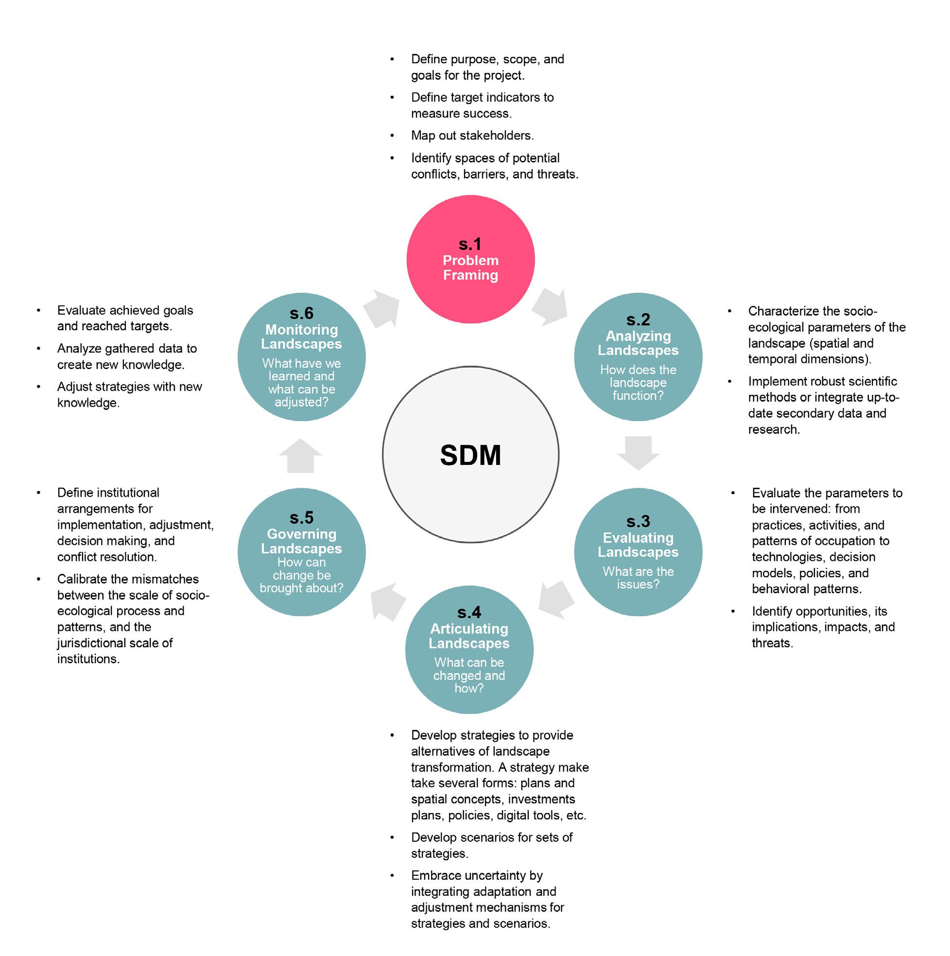
Our competitors are large consulting firms and university research centers populated with professionals from engineering, economics, or any combination of StEM1 disciplines. This is the world of strategy consulting firms, an industry sector that rewards specialization and the figure of the expert professional with extensive experience. To compete in such a market, however, we offer a combination of robust analytical methods— which provide accountability in decision making—with strategy, design, and creativity. We refer to this as a strategy-driven model (SDM), which is a six-step framework to articulate landscapes and processes that respond to socio-environmental challenges in a prospective manner. The SDM draws from a corpus of landscape planning methodologies2,3 developed over the last thirty-five years4 and more recent adaptive management approaches in conservation planning5 [FIG. 1].
Through a systematic review of projects commissioned by public institutions, we noticed that most of them focused on a single step of the SDM. For example, we found numerous analytical studies exploring specific, socio-environmental issues, but at the same time those studies didn’t provide alternatives to address or solve them. Conversely, we discovered planning proposals that weren’t rooted in analysis or even
Landscape Approach
266
secondary scientific data—only assumptions—rendering them too risky to be implemented by authorities. Most critically, we detected a plethora of policies and public programs that never saw implementation because they lacked an adequate institutional framework for it. In sum, a constellation of isolated projects with good intentions—some repeated several times—that ended up archived and eventually lost after each government administration. After this extensive review, we figured that an appropriate value proposition was perhaps a project methodology that could to some extent articulate the entire SDM framework.
Fig.1 The strategy-driven model (SDM): Note that each step can be framed as a guiding question. Flavio Sciaraffia
267A
Strategy-Driven Model for Sustainable Socio-Environmental Transformations in Chile
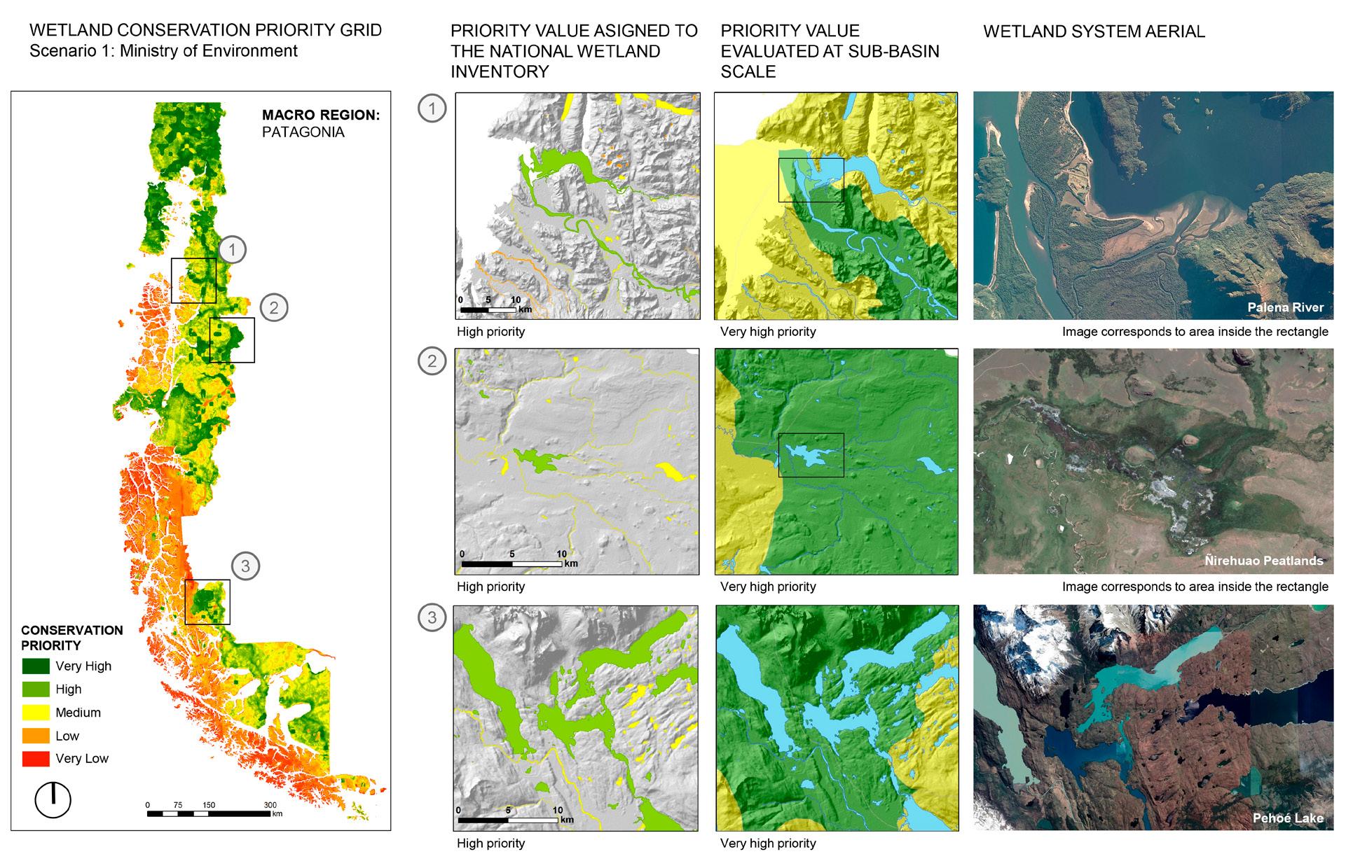
Fig.2 Wetland conservation priority
GIS application: The application takes the form of a geospatial model that allows stakeholders assigning relative weights to variables and indicators. Once the weights are set, the model yields a high-resolution grid (30x30 meters) at national scale with priority values for each cell. The model then eval uates the grid values overlapping with the wetlands in the inventory and assigns a final priority value for each wetland. The figure shows results for the southern edge of the country based on a scenario created by the Department of Aquatic Ecosystems of the Ministry of Environment. The map on the left is the priority grid. The maps in the first column show the priorities for each wetland in the example. The maps in the second column show the priority at the sub-basin scale. This is another functionality of the application and allows contrasting how variables and indicators behave at the wetland scale and the next hydrological scale above.
Flavio SciaraffiaOur main innovation, however, is not the SDM, which is a model that builds over a bulk of existing methodologies, but the realization that a successful project is one that spills over the entire process—albeit conceptually—either by considering previous steps or by anticipating and enabling the steps following further ahead. Thus, the value proposition conceives each project within the entire framework, understanding that its products need to account for the full sequence of the SDM model— even if our client requires us to focus just on a single step. We thus started developing our project proposals with that rationale. Eventually they caught the eye of public institutions, and soon after we saw our projects working to solve a wide range of socio-environmental challenges: from development planning to conservation planning, and from urban and infrastructure planning to regional and resource planning.
The Strategy-Driven Model in Practice: Two Case Studies in Chile
The strategy-driven model provides a whole-system approach to address socio-environmental challenges. It secures the project viability, while ar ticulating strategies that act over the landscape. The model can be im plemented in a range of topics, dimensions, and challenges, and it is a framework that systematically adds value to the initial project scope de fined by the client. In addition to the framework, the SDM integrates five principles6 that need to be considered throughout its execution. First, the “multi-scale” principle, which allows the reconciling of the mismatches that occur between the scales of governance and the progression of spa tial and temporal scales of territorial processes and patterns. Second, the consideration that landscape patterns and processes are conditioned by the jurisdictional and geographical limits on which they unfold; find ing the “interlinkages across limits” secures capturing the complexity of landscapes. Third, the “integrative” principle which allows aligning stake holders’ interests and negotiating trade-offs to create synergies across the landscape. Fourth, “adaptive strategies” that are more adequate to respond to unexpected change and can integrate new knowledge to reduce future uncertainty and increase resilience of landscape articulations. The last principle is based on the understanding of challenges in their “spatial (or geographical) dimension.” Spatially explicit analyses and strategies drive stakeholders towards shared goals, fostering consensus and, therefore, fa cilitating new landscape articulations.
In what follows, I present two projects that work as case-studies for the SDM. The reader is encouraged to associate the project process with the SDM framework in figure 2, as well as identifying how the principles are captured through the project activities.
Landscape
268
Approach
Case 1: Prioritizing National Wetlands Inventory for Conservation
Chile’s National Wetland Inventory identifies over 5.6 million hectares of wetlands (7.4 percent of the country’s gross area). Of these, 38 percent are under a protection category. Wetlands in its wide definition7 are present along and across the country thanks to the Andes Mountains that draw rain from the ocean accumulating water in the form of snow and cente nary glaciers. The interaction between drainage patterns, varied geomor phologic settings, and human activities gives way to a mosaic of coastal, continental, and artificial wetlands. Looking to meet national and interna tional targets in biodiversity conservation,8 the Ministry of Environment (MMA), our client, tasked us with prioritizing wetlands to guide conserva tion efforts. Prioritizing conservation is usually necessary because of con ditions like limited resources, time, and political commitments. In this case, prioritization was also necessary because of a growing inventory of over 100,000 unique wetlands.
Initially, the client required a list of prioritized wetlands as the main product. We started with a comprehensive review of the state-of-the-art in wetland prioritization, encompassing national and international methodologies. Factoring in the recurrent updating of the inventory 9 which denotes how dynamic wetlands and their management are—we proposed the development of a geospatial tool that could plug-in to the
269A
Strategy-Driven Model for Sustainable Socio-Environmental Transformations in Chile
inventory and provide prioritization scenarios as needed. The tool is a GIS (Geographic Information System) application and was built using a visual programming interface. It prioritizes wetlands by evaluating spatial information from thirty variables packaged in five indicators that work as prioritization objectives: biodiversity conservation, water resources conservation, threats mitigation, carbon sequestration, and cultural ecosystem services [FIG. 2]
A new scenario can be generated by assigning relative weights to variables and indicators in the application. The objectives were defined with the client and capture specific institutional commitments and goals in wetland conservation. Several workshops were held with academic and public stakeholders to validate the objectives and variables, and to create alternative scenarios that resonate with each stakeholder’s priorities. As government administrations change, and with it the MMA’s programmatic agenda, the tool could accommodate incoming priorities, remaining relevant as different ministerial cabinets put forward their conservation agendas. By integrating the views of many stakeholders, the tool set the ground for a shared governance in wetland conservation, reducing the likelihood of conflict when deciding what—and what not—to conserve. A case in point during the project were the conflicting views between the MMA and the scientific community. For the former, priority was mostly based on the threats the wetland ecosystems were facing, whereas the latter considered that biodiversity conservation was the most important objective. Both views were able to converge in a scenario with shared priorities. We finalized the project by establishing a protocol to update the information on which the prioritization is made and by designing a flexible structure to integrate new objectives, if necessary, therefore equipping the tool with a built-in adaptation mechanism. Currently, the tool is in the process of being uploaded to the MMA’s national biodiversity information system which houses data and applications to aid conservation efforts at different governance levels.
Case 2: Implementing the Urban Wetland Protection Law
In 2020, Chile passed a legislation to protect wetlands in urban contexts. This bill represents a general paradigm shift in conservation that has been applied in other contexts as well. It follows discussions in nature conserva tion which state that conservation does not mean an incompatibility be tween human activities and natural ecosystems,10 proposing that it is the rational use—and not only the restriction of activities, uses, or access—that is the most effective conservation mechanism. Before this law, urban wet lands in Chile lacked legal recognition, making their conservation prob lematic.11 Wetlands in urban environments are subject to an array of threats like draining, filling, and fragmentation because of land use change. At the same time, it is in cities where their benefits are more felt and needed by communities (providing ecosystem services like coastal protection, water
270 Landscape Approach
purification and accumulation, food sources, biodiversity, and recreation). Thus, the law enables municipalities to identify and declare their urban wetlands, bestowing them with normative tools to conserve them. It also means that local governments acquire a series of responsibilities that will require new resources and capacities that are not often found in local en vironmental and planning departments. For example, the law requires the modification of municipal zoning plans to establish compatible uses and urbanistic conditions near declared wetlands; it also requires implementing a conservation management plan with specific measures based on identi fied threats. After our involvement in developing the bylaws of the legis lation, the Ministry of Environment tasked us with designing a skill-de livering program—consisting of knowledge products, such as courses and guidelines—that could support and enable the implementation of the law by local governments.
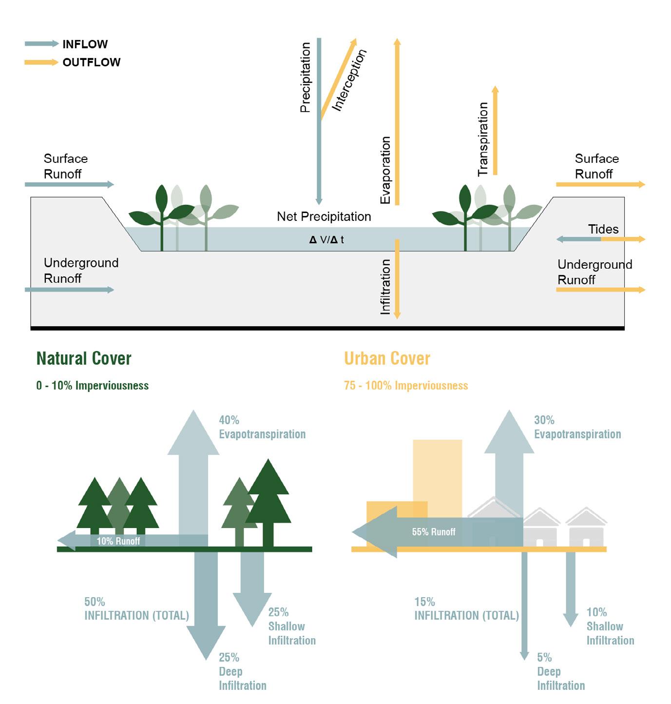
In Chile, municipalities are the smallest unit of local government and where most traditional urban planning takes place. There are over three hundred municipalities with stark differences in resources and professional capacities. With the law already in force, we set the focus on defining a strong monitoring system that could accompany its implementation and aid the MMA in defining an appropriate support package for municipalities. We started by analyzing the current state of municipal management to assess whether local governments were adequately prepared or not to implement the law. Using public data, we developed an indicator system covering five dimensions of municipal management: environmental management, urban planning, civic participation, and public investment. For example, we examined how up-to-date local zoning plans were, if funded projects were successfully executed, and if there was an existence of participatory mechanisms, among other factors. Evaluating the indicator allowed us to carefully mediate between local realities and the expectations of the central government. The MMA realized that a one-size-fits-all approach to support the implementation was not possible because of the diverse municipal landscape. Using the indicator, we took a snapshot of the state of municipal management in 2020 and used the insights to design knowledge products for municipalities. We developed a series of selfguided online courses and guidelines covering basic and more advanced topics pertaining to urban wetlands. Topics included: the law and its implications to municipalities, procedural and normative aspects of the legislation, the state of urban wetlands in Chile, wetland hydrology and biology, threats to wetlands in urban environments, and wetland management, among others [FIG. 3].
To test the suitability of our monitoring system, we piloted one course dealing with the first steps of the law implementation, which involves the declaration of urban wetlands following a series of technical requirements per the bylaws. This includes the process of identifying
A Strategy-Driven Model for Sustainable Socio-Environmental Transformations in Chile
271
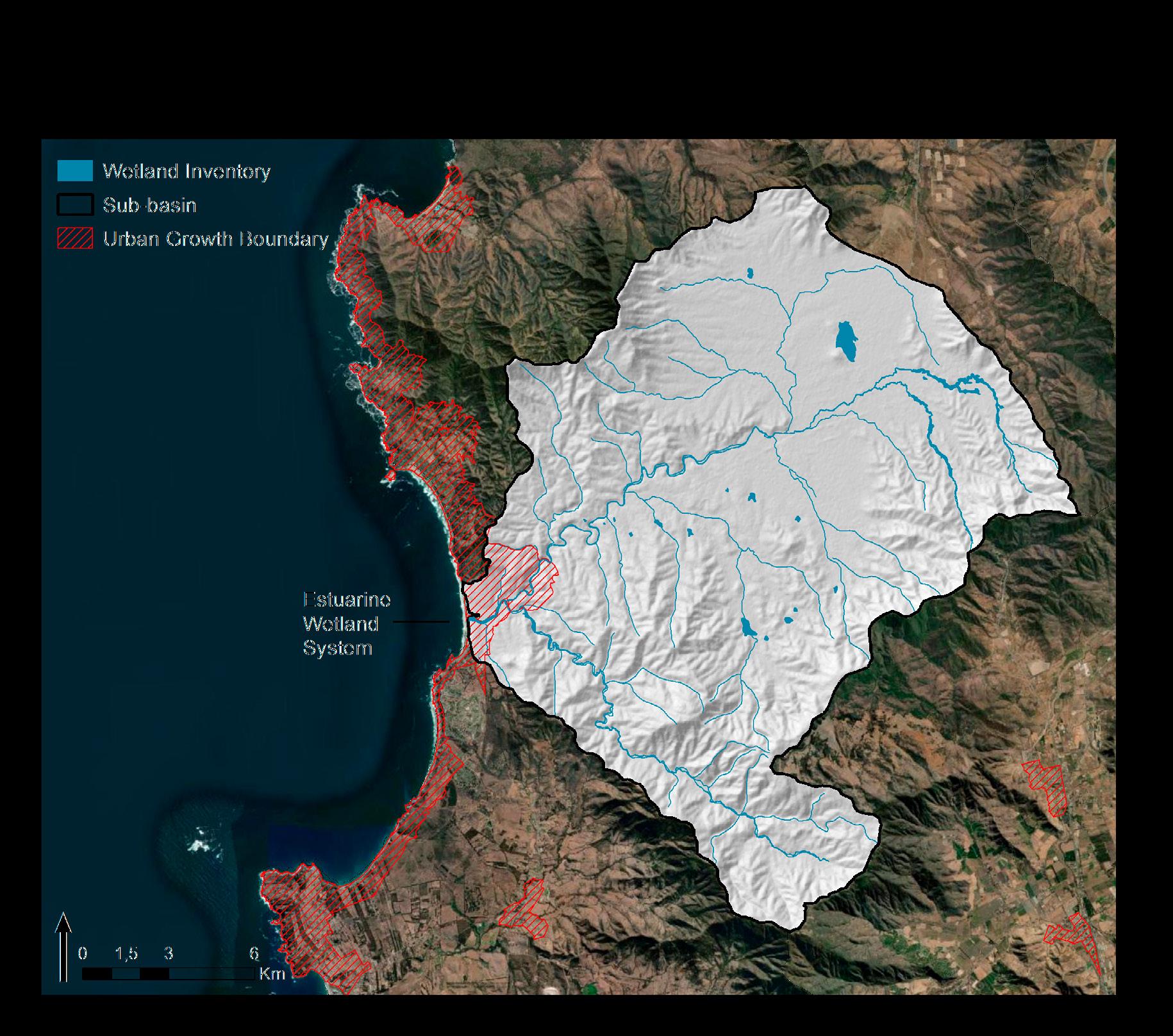
Fig.3 A sample of the information inside the knowledge products (guidelines and courses) designed to support the implementation of the Urban Wetland Law. Top: General model for the water balance of a wetland. Bottom: The impacts of urbanization in hydrological processes. Opposite page: Concept of drainage basin as a management scale for wetland conservation. Flavio Sciaraffia
and delineating wetlands, identifying threats and the benefits they provide for urban populations, and evaluating the ecological value of wetlands. Our team prepared this course and its materials over a period of six weeks in May 2021. More than half (#181 or 52 percent) of the country’s municipalities subscribed and took the course, along with other regional level institutions. This proof-of-concept validated the usefulness of the monitoring system by providing practical insights in developing knowledge products. As part of the pilot, we also advised a selected group of municipalities in different aspects of law using the guidelines developed by us. Looking ahead, we expect that the yearly update of the indicator system enables a recurrent monitoring of municipal management, providing the inputs to adjust the MMA’s skill-delivering program and support packages.
Lessons from the Implementation of the SDM in Chile
1. Landscape at the core of the strategy-driven model: In my prac tice we work under the assumption that the cultural project of humanity
272 Landscape Approach
is enabled by a strong interdependence between societies and ecosystems, and that such entanglements are often disturbed by unsustainable land scape patterns of occupation and transformation. As such, our response focuses on articulating new landscapes—socio-environmental systems— where humans are agents of sustainability12 as much as they are drivers of regressive landscape transformations. For this to happen, we believe it is critical to develop projects within a framework that allow explaining, eval uating, and/or changing the parameters and structures by which human societies give form to and modify landscapes. The SDM enables this for us. It allows exploring both the causes of problems and how to change re gressive trajectories of landscape transformations.
2. Accountability and creativity in tandem: Scientific rigorousness and design coalesce in the SDM.13 The former provides accountability, which is necessary for public decision-making; it has also given us cred ibility amid a professional space overcrowded with specialist practices. The latter provides us with flexibility and creativity to think of adaptable solutions and strategies.
A Strategy-Driven Model for Sustainable Socio-Environmental Transformations in Chile
273
3. Working for impacts at scale: As a principle of the SDM, working in a progression of scales is important because socio-environmental processes unfold at scales beyond a specific site. For us, and for most decision-mak ers in the public sector for that matter, the solution must be, unequivocally, at the scale(s) of the problem—both spatial and temporal. For designers, this means conceiving solutions under the concepts of strategy, scalabil ity, flexibility, adaptation, and uncertainty. As a practice, we have decided to pull the strings that exert change at large landscape scales. Including other cases not discussed in this paper, the following projects stand out because of their impact:
• We defined the planning and sustainability criteria of the Urban Wet land Law under which over 460,000 hectares of urban wetlands could be integrated as green infrastructures in Chilean cities.
• We set up a template of municipal ordinance with actions, measures, and standards to guide municipalities in the management of their urban wetlands. This is national-level policy acting at a local scale.
• We provided a roadmap for the Ministry of Environment for an ad equate rollout of the Urban Wetland Law by understanding the in tricacies of municipal governance at national scale.
• We were responsible for developing a climate risk adaptation plan for the Metropolitan Region of Santiago, an area where 40 percent of the country’s population live.
4. A viable model for design-led practices: The better part of two years passed before our model of practice was deemed attractive by the public sector—our main client. We feel the patience and persistence was worth it since it has allowed us to provide the much sought “expertise” with an expanded value proposition. So far, we have worked on diverse so cio-environmental challenges across sectors, and at national, regional, and local scales. Projects on topics like climate change, biodiversity conserva tion, economic development, and policy making are part of our portfolio. Thus, we believe the SDM is a viable model for other design-led practices seeking similar objectives.
274 Landscape Approach
Endnotes
1. Science, technology, engineering, and mathematics.
2. André Botequilha Leitão and Jack Ahern, “Applying Landscape Ecological Concepts and Metrics in Sustainable Landscape Planning,” Landscape and Urban Planning 59, no. 2 (January 2002): 66–70.
3. Jack Ahern, “Theories, Methods and Strategies for Sustainable Landscape Planning,” in From Landscape Research to Planning: Aspects of Integration, Education and Application, ed. Tress et al. (Dordretch: Springer, 2006), 125–128.
4. The two previous references (Botequilha and Ahern, and J. Ahern) provide a summary of the main frameworks in the American tradition; in chronological order these are: (1) Landscape Planning by Julius Gy. Fabos (1985); (2) Framework Method for Landscape Planning by Carl Steinitz (1990); (3) Landscape Ecology by Richard T. T. Forman (1995); (4) Framework Method for Sustainable Landscape Ecological Planning by Jack Ahern, (1999); (5) Ecological Planning Model by Frederick Steiner (2000); (6) Sustainable Land Planning by André Botequilha and J. Ahern (2002).
5. Conservation Measures Partnership (CMP), Open Standards for the Practice of Conservation Version 4.0. (2020), 2–7, https://conservationstandards.org/ download-cs/.
6. Jianguo Liu and William W. Taylor, “Coupling Landscape Ecology with Natural Resource Management: Paradigm shifts and New Approaches,” in Integrating Landscape Ecology into Natural Resource Management, ed. Liu, Taylor. (Cambridge: Cambridge U. Press, 2002), 8–11.
7. As a contracting party of the Ramsar Convention, Chile adopted a similar definition for wetlands, which is generally wide: (…) “extensions of marshes, swamps, and peats, or surfaces covered with water, whether of natural or artificial regimes, permanent or temporaries, with water that is stagnant or flowing, fresh, brackish or salt, including extensions of marine water, the depth of which at low tide does not exceed six meters.”
8. As a member of the Conference of The Parties (COP), Chile committed to the Aichi Biodiversity Goals of the Convention on Biological Diversity. Target 11 states that by 2020, at least 17 percent of terrestrial and inland water, and 10 percent of coastal and marine areas, should be conserved through protected areas. Chile has made significant efforts and even exceeded the original targets.
9. The National Wetland Inventory set up an updating protocol where different levels of governance, from local to regional, and national, can incorporate new information based on new wetland delimitation efforts, and corrections of existing ones. The inventory is updated yearly, with sometimes weekly and monthly updates in between.
10. Thomas Campagnaro, Tommaso Sitzia, Peter Bridgewater, Douglas Evans and Erle C. Ellis, “Half Earth or Whole Earth: What Can Natura 2000 Teach Us?” BioScience 69, no. 2 (February 2019): 119.
11. Chile has a Civil Law legal system, meaning that court decisions are based on the codified law and precedent is less important. For example, until 2020 the Environmental Evaluation System could not consider impacts on wetlands since this type of ecosystem wasn’t codified in the text of the environmental law.
12. Jianguo Wu, “Landscape Ecology, Cross-Disciplinary, and Sustainability Science,” Landscape Ecology 21 (2006): 3.
13. Joan I. Nassauer and Paul Opdam, “Design in Science: Extending the Landscape Ecology Paradigm,” Landscape Ecology 23, no. 6 (2008): 636.
Strategy-Driven Model for Sustainable Socio-Environmental Transformations in Chile
275A