HOME BOOK
PREPARED FOR:


Email-based, real estate fraud schemes are on the rise. One common scenario is altering wiring instructions with the intention of rerouting funds.
Keeping this in mind, First American Title is changing the way we receive payment information. It is imperative that we are familiar with the people in our transactions.
Fraudsters often use email to send falsified wire instructions to unsuspecting victims. Please warn your buyers and sellers to only follow wire instructions they receive personally from First American Title.
Additionally, we will not accept disbursement instructions for seller or buyer funds via email OR from any third party (attorney, real estate agent, etc).
If your buyer or seller receives alternative wiring instructions that appear to be from First American Title, make sure they contact their escrow officer at a trusted phone number for confirmation.
Know that our wiring instructions do not change so any communication is suspect. Our banking institution is First American Trust.
IN SHORT – wire instructions will not be accepted by email. New wire instructions must be hand-carried or uploaded to the First American Secure Portal.
Thank you for joining First American Title in fostering a secure real estate transaction process. Have questions or concerns? Please contact our office or your escrow officer.
For more information please contact your First American representative. www.firstam.com
This report is not an insured product or service or a representation of the condition of title to real property. It is not an abst ract, legal opinion, opinion of title, title insurance commitment or preliminary report, or any form of Title Insurance or Guaranty. This report is issued exclusively for the benefit of the Applicant therefor and may not be used or relied upon by any other person. This report may not be reproduced in any manner without First American or Title Security's prior written consent. First American or Title Security does not represent or warrant that the information herein is complete or free from error, and the information herein is provided without any warranties of any kind, as-is, and with all faults. As a material part of the consideration given in exchange for the issuance of this report, recipient agrees that First American or Title Security's sole liability for any loss or damage caused by an error or omission due to inaccurate information or negligence in preparing this report shall be limited to the fee charged for the report. Recipient accepts this report with this limitation and agrees that First American or Title Security would not have issued this report but for the limitation of liability described above. First American or Title Security makes no representation or warranty as to the legality or propriety of recipient's use of the information herein.

Data Provided By:
First American Title Ins Co

This REiSource report is provided "as is" without warranty of any kind, either express or implied, including without limitations any warrantees of merchantability or fitness for a particular purpose. There is no representation of warranty that this information is complete or free from error, and the provider does not assume, and expressly disclaims, any liability to any person or entity for loss or damage caused by errors or omissions in this REiSource report without a title insurance policy.
The information contained in the REiSource report is delivered from your Title Company, who reminds you that you have the right as a consumer to compare fees and serviced levels for Title, Escrow, and all other services associated with property ownership, and to select providers accordingly. Your home is the largest investment you will make in your lifetime and you should demand the very best.

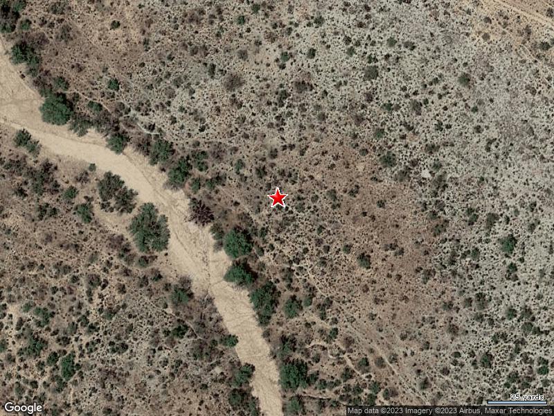
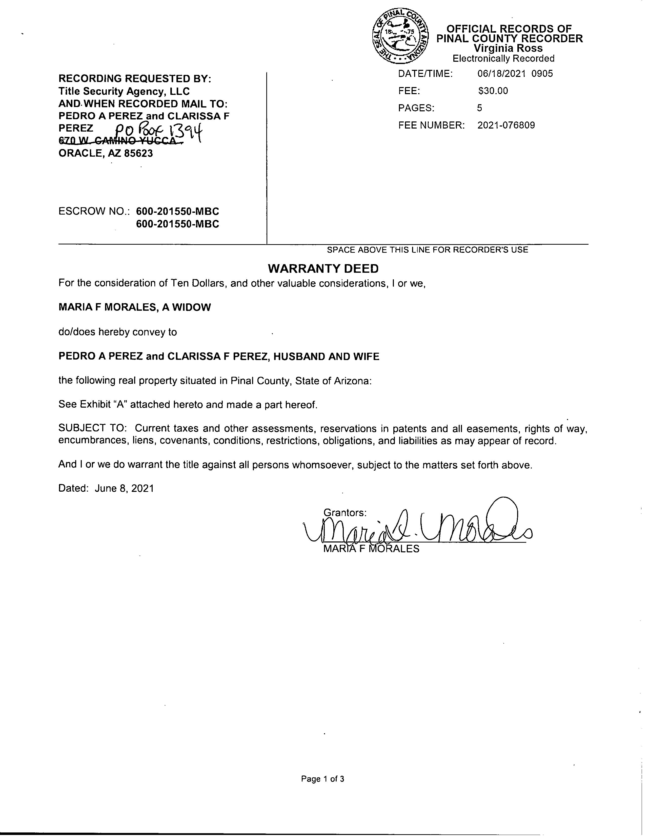
Subject Property : Oracle AZ 85623
Owner Information
Owner Name : Perez Pedro A / Perez Clarissa F
Mailing Address : Po Box 1394, Oracle AZ 85623-1394 B016
Location Information
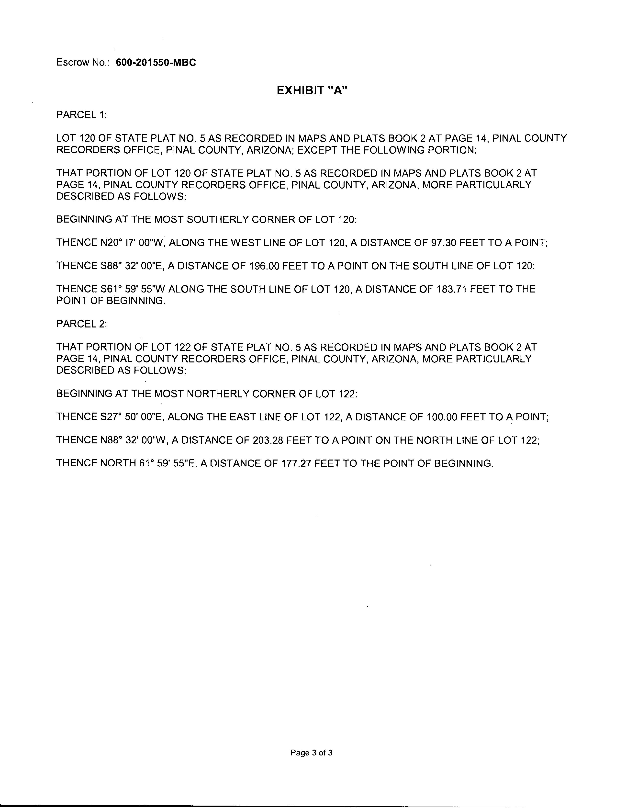
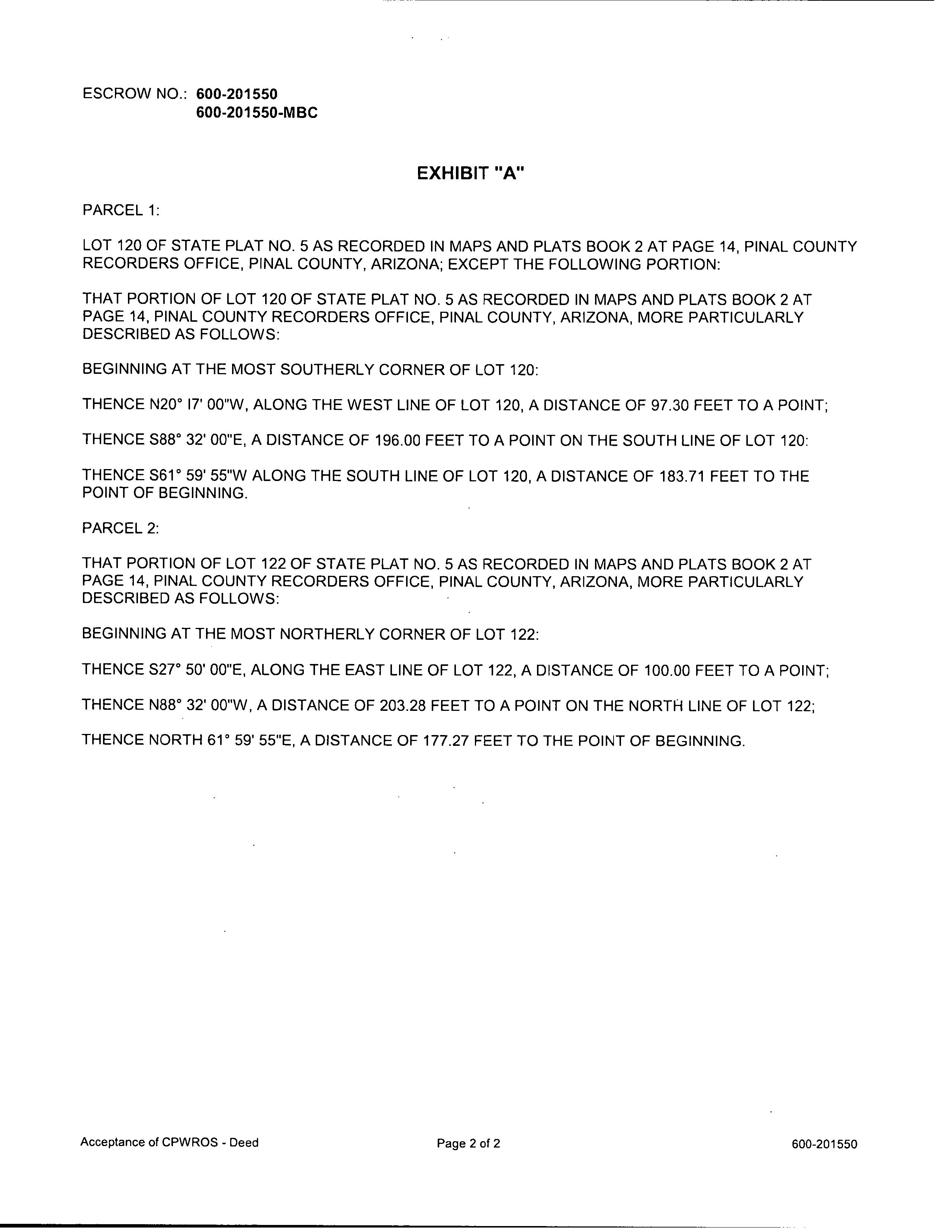
Legal Description : Oracle State Tracts: Lt 120; & That Por Of Lt 122 Beg At The Mostnly Cor Of Lt 122; Th S-27 Deg E-100' Th N-88 Deg W-203.28' Th N-61 Deg E-177.27' Exc Tri In Sly Cor Of Lt 120 Sec 36-9s-15e 1.30ac
County : Pinal, Az
Census Tract / Block : 22.00
Township-Range- Sect : 09S-15E-36
Legal Lot : 120
Last Market Sale Information
Recording/Sale Date : 06/18/2021 / 06/08/2021
Sale Price : $55,000
Document # : 76809
Title Company : Title Sec Agcy Llc

Seller Name : Morales Maria F
Prior Sale Information
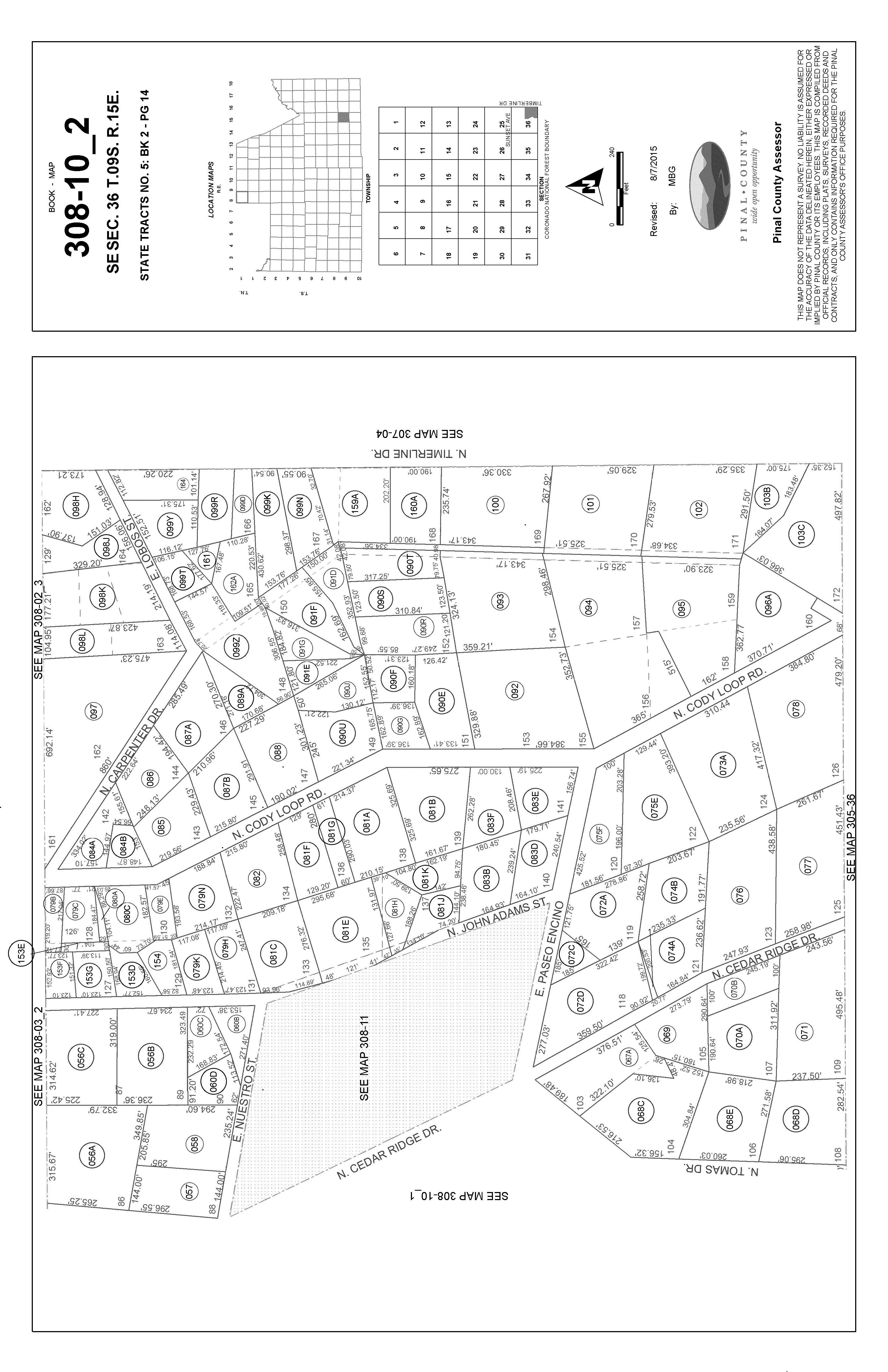
APN : 308-10-075F
Subdivision : State #5
Map Reference : 3609S15E
Deed Type : Warranty Deed
Price Per SqFt : $0.97
Prior Rec/Sale Date : 04/02/1991 / 04/02/1991 Prior Deed Type : Joint Tenancy Deed
Prior Doc Number : 1736-208
Property Information Land Use : Residential Acreage
Zoning : SINGLE RESIDENCE ZONE
Tax Information
Acres : 1.30
Use : Vac Res-urban Subd
Total Value : $42,590 Tax Year : 2022
Total Taxable Value : $6,389
Customer Name : Jeremiah Stiffler Customer Company Name : First American Prepared On : 09/07/2023



Customer Name : Jeremiah Stiffler
Customer Company Name : First American Prepared On : 09/07/2023
© 2023 CoreLogic. All rights reserved
Customer Name : Jeremiah Stiffler
Customer Company Name : First American Prepared On : 09/07/2023
© 2023 CoreLogic. All rights reserved

200 N CODY LOOP RD Distance 0.04 Miles
Owner Name : Read Halley (te)
Recording Date : 05/28/1991
Sale Date : 05/28/1991 Sale Price : $90,000
Total Value : $129,127
Property Tax : $1,106.08
Land Use : Sfr Lot Acres : 1.90
Stories : 1 Living Area : 1,422
Yr Blt / Eff Yr Blt : 1940 / APN : 308-10-075E
Subdivision : State 05
1290 E PASEO ENCINO Distance 0.04 Miles

Owner Name : Stager Terrell J Recording Date : 07/15/2003
Sale Date : 07/03/2003 Sale Price : $240,000
Total Value : $207,625 Property Tax : $2,010.98
Land Use : Sfr Lot Acres : 0.82
Stories : 1
Living Area : 2,113
Yr Blt / Eff Yr Blt : 1996 / APN : 308-10-083E
Subdivision : Oracle State
1212 E PASEO ENCINO Distance 0.04 Miles
Owner Name : Wnek Donald Recording Date : 11/10/2021
Sale Date : 10/08/2021 Sale Price : $245,000
Total Value : $139,264
Property Tax : $1,107.10
Land Use : Sfr Lot Acres : 0.85
Stories : 1
Living Area : 1,052
Yr Blt / Eff Yr Blt : 1994 / APN : 308-10-083D
Subdivision : State 05
1165 E PASEO ENCINO Distance 0.05 Miles
Owner Name : Huffman James R Subdivision : State 05
Sale Date : 09/16/1986
Total Value : $207,107
Recording Date : 09/16/1986
Property Tax : $1,714.18
Land Use : Sfr Lot Acres : 1.45
Stories : 2
Living Area : 2,410
Yr Blt / Eff Yr Blt : 1981 / APN : 308-10-072A
Customer Name : Jeremiah Stiffler
Customer Company Name : First American Prepared On : 09/07/2023
© 2023 CoreLogic. All rights reserved
149 N CEDAR RIDGE DR Distance 0.06 Miles
Owner Name : Howell Matthew V
Recording Date : 08/18/2022
Sale Date : 08/03/2022 Sale Price : $340,000
Total Value : $251,475
Property Tax : $1,809.74
Land Use : Sfr Lot Acres : 1.05
Stories : 1 Living Area : 1,840
Yr Blt / Eff Yr Blt : 2002 / APN : 308-10-074B
Subdivision : State # 5
364 N CODY LOOP RD Distance 0.07 Miles
Owner Name : Wolff Stuart
Recording Date : 11/04/2022
Sale Date : 10/12/2022 Sale Price : $368,500
Total Value : $164,351 Property Tax : $1,593.12
Land Use : Sfr Lot Acres : 0.81
Stories : 1
Living Area : 1,520
Yr Blt / Eff Yr Blt : 1994 / APN : 308-10-083F
Subdivision : State 05
333 N JOHN ADAMS ST Distance 0.08 Miles
Owner Name : Torres-taylor Suzanne
Recording Date : 06/24/2020
Sale Date : 06/02/2020 Sale Price : $280,000
Total Value : $232,214 Property Tax : $2,294.90
Land Use : Sfr Lot Acres : 0.94
Stories : 1
Living Area : 1,682
Yr Blt / Eff Yr Blt : 2015 / APN : 308-10-083B
Subdivision : State #5
1125 E PASEO ENCINO Distance 0.08 Miles

Owner Name : Robinson Richard L (te) Subdivision : State 05
Sale Date : 05/31/1996
Total Value : $115,606
Recording Date : 05/31/1996
Property Tax : $1,070.74
Land Use : Sfr Lot Acres : 0.35
Stories : 1
Living Area : 1,320
Yr Blt / Eff Yr Blt : 1982 / APN : 308-10-072C
Customer Name : Jeremiah Stiffler
Customer Company Name : First American Prepared On : 09/07/2023
© 2023 CoreLogic. All rights reserved
176 N CODY LOOP RD Distance 0.09 Miles
Owner Name : Cook Phillip J Recording Date : 05/28/1986
Sale Date : 05/28/1986 Sale Price : $35,000
Total Value : $94,264 Property Tax : $1,065.12
Land Use : Sfr Lot Acres : 2.47
Stories : 1 Living Area : 672
Yr Blt / Eff Yr Blt : 1988 / APN : 308-10-073A
Subdivision : State 05
169 N CEDAR RIDGE DR Distance 0.09 Miles
Owner Name : Kauffman Adrienne Y Recording Date : 10/19/2022
Sale Date : 10/03/2022 Sale Price : $225,000

Total Value : $131,877 Property Tax : $1,173.36
Land Use : Sfr Lot Acres : 1.25
Stories : 1 Living Area : 752
Yr Blt / Eff Yr Blt : 1999 / APN : 308-10-074A
Subdivision : State # 5
Customer Company Name : First American Prepared On : 09/07/2023
© 2023 CoreLogic. All rights reserved
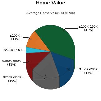
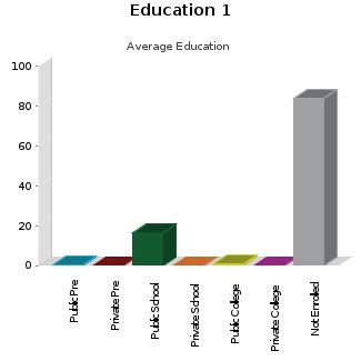
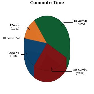
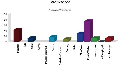
Customer Name : Jeremiah StifflerCensus Tract / block: 22.00 Year: 2020


Customer Name : Jeremiah Stiffler
Customer Company Name : First American Prepared On : 09/07/2023

© 2023 CoreLogic. All rights reserved
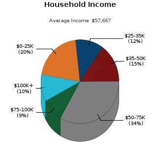
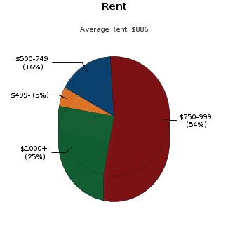
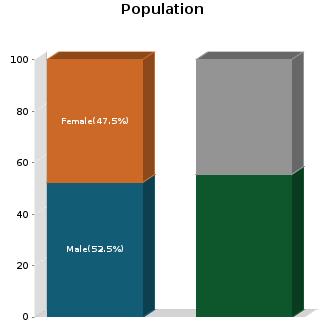
Customer Name : Jeremiah Stiffler
Customer Company Name : First American Prepared On : 09/07/2023

© 2023 CoreLogic. All rights reserved
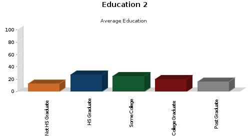
Customer Name : Jeremiah Stiffler
Customer Company Name : First American Prepared On : 09/07/2023

© 2023 CoreLogic. All rights reserved


This map is provided for general location only. Please contact school districts for actual street boundaries
PARCEL: 308-10-075F
PARCEL: 308-10-075F 3
OWNER: PEREZ PEDRO & CLARISSA
MAIL: PO BOX 1394
LEGAL: ORACLE STATE TRACTS: LT 120; & THAT POR OF LT 122 BEG AT THE MOSTNLY COR OF LT 122; TH S-27 DEG E100' TH N-88 DEG W-203.28' TH N -61 DEG E-177.27' EXC TRI IN SLY COR OF LT 120 SEC 36-9S-15E 1.30AC
ADDITIONAL PROPERTY INFORMATION STANDARD LAND USE:
We are providing the requested information without CC&Rs. Unfortunately, we are unable to confirm CC&Rs at this time, possibly because:
The property is too complex to obtain CC&Rs without a complete title examination
The property is sectional, whereas there are no “standard” subdivision‐type restrictions
A recorded plat may not exist
The recorded plat may be older, with limited information available, or
Recorded CC&Rs may not exist.
Once escrow is opened, the property will be thoroughly examined. CC&Rs and other matters that may “run with the land” will be disclosed in Schedule B of the Commitment for Title Insurance.
If you have questions, or need additional information at this time, please contact your First American or Title Security Account Manager or Escrow Officer.
