CYCLE & WALKING TRAILS Redlands Hill Reserve
Nulla Nulla Swamp & Redlands Hill Trail
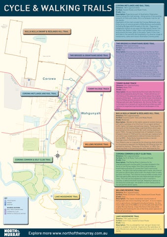
Corowa Wetlands and Rail Trail
Distance: 18km approximately Surface: Sealed Roads and Made Trails Grade: Easy Description: Experience part of Australia’s Federation History along this trail journey. Using some of the existing network of trails and roads, this is a fantastic trail for all the family. Highlights of this trail include the Corowa Wetlands area. Enjoy acres of natural growth of Billy Buttons and wildlife including Brolgas which breed on the site. Experience indigenous history as you pass the Aboriginal Canoe Tree located near Baden Lodge. Take a self guided journey in and around the town, play in the parks, swim in the river and take in the warmth and hospitality of a diverse range of restaurants, cafes and classic Australian Country pubs.
Albu How ry 55km long 28km
Nulla Nulla Swamp
TWO BrIdGEs & GranTHaMs BEnd TraIL distance: 10km approximately surface: Sealed Roads and Earth Trails Grade: Easy description: Discover the true beauty of the Murray River on this trail with breathtaking views from Granthams Bend. Granthams Bend provides numerous tracks meandering through the forest and offers plenty of good fishing spots to catch the famous Murray Cod. The John Foord and Federation Bridges connect Corowa and Wahgunyah. The John Foord Bridge construction was completed 1892 and named after early pioneer John Foord. A new bridge was officially opened on 2 April 2005, known as the Federation Bridge named in recognition of the significant role Corowa played in the formation of the Nation of Australia as we know it today. A series of structural features on the Federation Bridge include the Federation Arch and the Barassi Line, a set of Australian Rules Football posts.
Two Bridges & Granthams Bend Trail
Deep Lead Site
n7
Pr
op
ga rri
os ed
Be
Tr a
il
Grantham’s Bend
m
0k
TOMMy MCraE TraCk
8
distance: 3km approximately surface: Made Trail Grade: Easy description: As you travel along this track take the time to read the storyboards along the way. These will tell you of the history of the area and cultural facts about the original owners of this land. It was a very fertile forest cherished by Tommy McRae and his ancestors. As you will see, between Wahgunyah and Lake Moodemere, the Tommy McRae Track is the basis for a network of tracks which provides you with options for experiencing the different landscapes of the area.
Tommy MCCRAE TRACK
Corowa Wetlands and Rail Trail 7
Bowls Club Proposed Civic Centre
Bangerang Park
Nulla Nulla Swamp & Redlands Hill Trail
6
Uncle Tobys
Wa h
gu
m
ny
ah
rgl
en
Ra
l
HER DR IVE
MOORE CT
Ru
ilT rai
GALLAG
Footbridge
to
the
RLEY DRI
VE
MO
la 37k Mulwa
WILLOWS RESERVE TRAIL KILBORN
RD
Morris Park
COrOWa COMMOn & GOLF CLuB TraIL
COROWA COMMON & GOLF CLUB TRAIL O’DONOG
HUES RD
GATE
GATE
Corowa Golf Club
Distance:19km approximately Surface: Country Earth Trails and Made Roads Grade: Moderate Description: Wonder at the idyllic pastoral scenes that you will catch a glimpse of on this trial. It is a region without traffic lights, toll ways and parking meters. Travel past the remnants of the Corowa Deep Lead Gold Mine which was proclaimed at the site during 1861 with mining ceasing in early 1900’s. Yuruga homestead (site of Caldwell’s Corowa Vineyard closed in 1940) and the concrete gun replacement site which was established to defend Corowa Aerodrome during WW2. Nulla Nulla Swamp provides a natural drainage area to Redlands Hill. Tom Roberts was so inspired by the shearing shed activities on the property opposite the Redlands Hill Reserve that he painted his famous “Shearing of the Rams” in 1890. The shearing shed in the painting was later destroyed by fire.
GATE
Ruthergle
GATE
THREE CH
AIN RD
n 8km
distance:15km approximately surface: Earth & Made Trails and Sealed Roads Grade: Easy description: The Murray River is famous for its championship golf courses with 3 courses situated in the North of the Murray region This 12km trail provides a breathtaking glimpse of Corowa Golf Club’s manicured course. The golf club trail provides earth tracks, any time of the year but particularly good under the shady trees on early summer mornings. The common area provides a lovely short 3km trail particularly along the river bank amongst the gum trees. This trail can be traveled by itself or started in Corowa, or before the Golf Club trail. Weaving in and out of the beautiful landscape, the wildlife is often nearby and so too are perfect picnic spots.
WILLOWs rEsErvE TraIL
GATE
KEY
LAKE MOODEMERE TRAIL
GRAHAM
S LANE
a 43km
TOILET BLOCK
WINERY
Wangara tt
MUSEUM BUSINESS LOCATIONS
LDS RD
FEDERA TION WA Y
G AT E
GATE
MCDONA
A BALL PARK CARAVAN PARK B COROWA RSL CLUB C WHISKY & CHOCOLATE FACTORY
MOO
DEM
ERE
RD
MURRAY
VALLEY
HIGHWAY
Explore more www.northofthemurray.com.au
distance: 8km approximately surface: Made and Earth Trails, Sealed and Gravel Roads Grade: Easy description: The classic Australian country town of Wahgunyah was once a bustling river port. It is in a region rich in agriculture, mining and viticulture history. On this track make use of the BBQ or sit on the jetty and watch the mighty Murray flow by. Enjoy the flora in the area while watching and listening for one of the forty seven species of birds all around you.
LAKE MOODEMERE TRAIL
Distance: 13km approximately Surface: Earth Trails, Sealed & Gravel Roads Grade: Easy Description: This is a delightful river red gum forest trail which is shaded in Summer. Experience the splendour of Lake Moodemere and why not stop and enjoy a picnic on its banks.