Joint Land Use Study Letterkenny Army Depot (Updated Summer 2016)
This study was prepared under contract with the Franklin County Area Development Corporation (FCADC), with grant support from the Pennsylvania Military Community Enhancement Commission (PMCEC).
The Letterkenny Army Depot (LEAD) Joint Land Use Study (JLUS) is a cooperative land use planning initiative between the Army, the Letterkenny Industrial Development Authority (LIDA), and surrounding Franklin County municipalities, as well as others responsible for planning, development, and communications in the area.
Acknowledgements
Grantee and Project Sponsor:
Franklin County Area Development Corporation
JLUS Technical Advisory Group Members:
John Van Horn, Executive Director, Letterkenny Industrial Development Authority
Todd Burns, Chair, Greene Township Board of Supervisors
Michael Kessinger, Chair, Hamilton Township Board of Supervisors
Charles Myers, Chair, Letterkenny Township Board of Supervisors
Phil Wolgemuth, Land Use and Development Director, Borough of Chambersburg
Colonel Deacon Maddox, Commander, Letterkenny Army Depot
LTC Trent Conner, Commander, Letterkenny Munitions Center
Edward Averill, Deputy to the Commander, Letterkenny Munitions Center
Phil Tarquino, Planning Director, Franklin County
Project Oversight and Grant Administration:
L. Michael Ross, Chair, Franklin County Area Development Corporation
The Technical Committee has been led by Martin & Martin, Incorporated, a Chambersburg Planning and Consulting firm, which assigned the following principal researchers:
Martin and Martin, Inc., Planning Consultants
Timothy C. Cormany, A.I.C.P.
Scott Shildt, Planner
EXECUTIVE SUMMARY
The Joint Land Use Study (JLUS) for the Letterkenny Army Depot (LEAD) is prepared in the context of the recognized need to provide coordinated land use planning policies between the adjacent, or impacted, civilian community and U.S. military installations
The objective of the JLUS program is twofold:
1) Encourage cooperative land use planning between military installations and the surrounding communities so that further community growth and development are compatible with the training or operational missions of the installation.
2) Seek ways to reduce the operational impacts on adjacent land. The JLUS program should encourage communities and the neighboring military installation to study the issues of incompatibility in an open forum, taking into consideration both community and military viewpoints.
It is intended that the recommendations in this study be used to guide local jurisdictions in the development and implementation of appropriate land use controls. Such controls should ensure that future development around LEAD will be compatible with both the military mission and the development needs of its host community.
Findings
Geographic conditions, aerial photography, environmental records, and existing land uses were examined during the course of the investigation, and representatives from LEAD, LIDA, and the surrounding municipalities were interviewed in order to determine existing and potential areas of incompatibility. The investigation resulted in the conclusion that the Depot is ideally located due to the relatively rural, undeveloped surrounding areas. Existing conflicts between LEAD and the surrounding communities are existent but minimal. Groundwater pollution and vapor intrusion resulting from past LEAD disposal practices continue to be an ongoing issue. The mitigation efforts initiated by the Army in the mid-1990s have been comprehensive but to date have not resulted in a significant reduction of the identified contamination plume. Ordinance detonation and rocket motor disposal operations by the Letterkenny Munitions Center (LEMC) are an integral part of daily operations and have been ongoing for decades. LEMC makes a concerted effort to coordinate disposal with appropriate meteorological conditions to minimize noise, dust, smoke, and vibrations from the munitions disposal mission.
Three additional concerns were identified during this planning exercise. The first of these is related to the protection and security of operations occurring at LEAD, referred to as Force Protection. The second has to do with radar testing missions conducted at the Depot. The third issue that raises concern from the community leadership is traffic.
The purpose of Force Protection is to prevent/deter aggressors, such as terrorists, from attacking the vital military operations at the Depot and, if an attack occurs, minimizing the resulting damage. The location of sensitive missions within the Depot and the business park, the unanticipated re-occupation of LIDA property by LEAD activities, their relation to surrounding outside land uses, and the accessibility to those missions need to be analyzed to determine the best methods of protection. Due to the proximity of operations occurring within the Depot, surrounding communities, and Business Park, as well as common traffic arteries, it is recommended that Greene Township, Letterkenny Township, LIDA and LEAD maintain a regular dialog concerning planning and methodology to achieve the greatest level of Force Protection. The effort must be made to ensure that there is no incompatible use of community land that threatens the safety and mission viability of the depot. Similarly, Force Protection within shared public areas must be designed and employed with consideration of, and minimal interruption to, other Business Park operations and public thoroughfares.
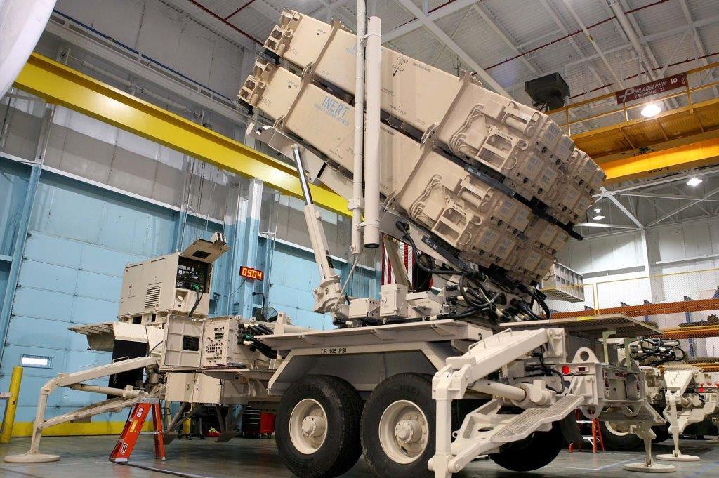
LEAD has secured and maintains an FCC license for conducting testing of the Hawk and Patriot Radar Systems. This reinforces the Letterkenny location as an invaluable asset to continued Department of Defense (DOD) operations. Radar testing occurs in relatively close proximity to property controlled by LIDA. Obstructions in the testing zones can present problems with the testing of these radar systems. Also, electronic interference from sources in the field of view of the radar can cause test results to be invalid. LIDA, being the area most often impacted by the LEAD Radar Test Missions, coordinates proposed construction activities located in the “active” radar testing direction with LEAD in order to minimize or eliminate potential sources of interference with the radar testing mission.
Vehicular traffic attempting to connect between the I-81 Exit 20 Interchange and entrances to LEAD and the Cumberland Valley Business Park has led to both local and LEAD concerns regarding congestion during shift changes and truck traffic utilizing the SR 0997 segment of road between the Route 11 intersection in the Village of Greenvillage and the SR 0433 intersection at the LEAD entrance next to the Village of Culbertson. Discussions of alternative truck routing, additional points of vehicle ingress and egress, and roadway and signalization modifications are critical to resolving these growing transportation concerns. Local municipalities, the Pennsylvania Department of Transportation, and the county’s transportation planning arm, the Franklin County Metropolitan Planning Organization (MPO), are critical resources in assisting the greater Letterkenny community with addressing these issues.
It is anticipated that development surrounding the Depot will remain largely controlled by the rural nature of the land. The Greene Township Zoning Map shows that the Cumberland Valley Business Park is zoned Heavy Industrial (HI). The area south of the business park is zoned Light Industrial (LI). There are narrow strips of Highway Commercial (HC) zones to the east and southwest of the Depot. The areas beyond these HC areas are zoned Low Density Residential (R1), of which some properties (six farms totaling over 900 acres) are protected agricultural land via recorded conservation easements. The nearby Village of Culbertson area is zoned Medium Density Residential (R-2). While Hamilton and Letterkenny Townships do not have zoning ordinances with coinciding land use restrictions, the abundance of agricultural and state land combined with the lack of public water and sewer facilities continues to effectively limit development to relatively low-density residential uses. It is expected that there will be negligible encroachment occurring in the foreseeable future. Continued development of the Cumberland Valley Business Park will be controlled by the Greene Township Zoning Ordinance and use and performance standards established by LIDA. Based on the existence of these controls, any development is unlikely to encroach or impact negatively on any Depot mission.
Recommendations for Consideration:
Consider initiating and implementing the following practices and policies:
1) Enhance community relations to ensure that citizens of the affected areas are kept informed through direct contact about the changes that may result from revisions or
additions to mission plans at LEAD and changes in the municipalities (including LIDA) which may affect LEAD.
2) Develop and coordinate education programs between LEAD, LEMC, CASD, local universities, and the local communities in order to provide occupational and vocational opportunities that will serve to develop and maintain a homegrown, skilled labor force capable of attracting and sustaining new technically demanding missions to LEAD.
3) Maintain a clearinghouse of data collected during the course of preparing this JLUS and beyond that can be made available to LEAD, the study area municipalities, and the public. These records may be maintained in the offices of the JLUS sponsor, FCADC, and/or the JLUS consultant, Martin and Martin, Incorporated.
4) The surrounding municipalities should consider requiring disclaimer notations on subdivision and land development plans for property in proximity to the Depot advising buyers of the potential negative externalities generated by mission activities at LEAD. By requiring such a note on plans the notification becomes accessible through the title search process and interested buyers are advised of the potential impact.
5) Monitor growth and change in the impacted municipalities in an effort to achieve early detection of potential encroachments on LEAD missions.
6) Maintain and improve regular communication among the leadership of the study area municipalities, LIDA, and LEAD. Local governments (including LIDA) should be encouraged to notify LEAD of specific proposals that may affect base missions. Such notification would allow LEAD to submit comments for consideration by local officials. LEAD should also be encouraged to notify local governments (including LIDA) concerning new missions that could impact, or be impacted by, adjacent land or land uses in order to address any potential issues. This will allow parties to provide comment at the concept stages and work together to develop best-fit solutions that are mutually agreeable.
7) In an effort to promote safety, efficiency and improved quality of life, it is recommended that LIDA, LEAD, the Franklin County MPO, and Greene Township work together closely to investigate possible improvements to the existing five-way intersection (SR0997, SR0433, and Coffey Avenue), and traffic routing between LEAD and Cumberland Valley Business Park, U.S. Route 11, and the I-81 Exit 20 Interchange at Scotland. In consideration of the study area’s regional economic significance, ongoing review of the Business Park and military traffic situation is an issue that should remain a regional priority for the life of these operations.
8) The majority of the above-referenced recommendations rely on a common thread to ensure successful implementation: improved communication between the community and LEAD. The affected parties should initiate leadership to establish a body that can meet regularly, and as otherwise needed, to discuss local,regional, and base developments and to work together to actualize the JLUS recommendations.
TABLE OF CONTENTS
TABLE OF ILLUSTRATIONS
TABLE OF ILLUSTRATIONS (continued)
NOTE: Illustrations and background mapping developed in the course of this planning study will be maintained in the offices of the consultant, Martin and Martin, Inc.
CHAPTER 1
Introduction, Study Objectives And
Joint Land Use Planning Process
Introduction
The background for undertaking a Joint Land Use Study (JLUS) for the Letterkenny Army Depot (LEAD) closely parallels the concern of the Department of Defense (DoD) about public health, safety and welfare when it established the program in 1985 by stating:
“Most military installations were originally located in remote areas, distant from urban areas due largely to the availability of land and for defense and security purposes. Over time however, installations drew people and businesses closer and closer to take advantage of civilian job opportunities offered by the installation and to provide the goods and services to support the installation’s operations. As urban growth and development increased near and around military installations land use conflicts between base operations and civilian development increased.
“Conversely, urban development near the perimeter of active military bases impacts operational effectiveness, training, and readiness missions.”
In response, the JLUS program was developed as “a cooperative land use planning effort between affected local government and the military installation.”
The objective of the JLUS program is twofold:
1) Encourage cooperative land use planning between military installations and the surrounding communities so that further community growth and development are compatible with the training or operational missions of the installation.
2) Seek ways to reduce the operational impacts on adjacent land. The JLUS program should encourage communities and the neighboring military installation to study the issues of incompatibility in an open forum, taking into consideration both community and military viewpoints.
It is intended that the recommendations in this study be used to guide local jurisdictions in the development and implementation of appropriate land use controls. Such controls should ensure that future development around LEAD will be compatible with both the military mission and the development needs of its host community.
This Joint Land Use Study is prepared in the context of the recognized need to provide coordinated land use planning policies between the adjacent, or impacted, civilian community and U.S. military installations. Incompatible urban development can constrain military installation mission activities and threaten national defense readiness. It also can unnecessarily expose adjacent residents to unacceptable negative externalities resulting from military operations. In short, joint planning activities can help resolve current incompatibility issues and avoid future conflicts.
The design of this document is based on multiple meetings and discussions with the Letterkenny Industrial Development Authority (LIDA), local municipal and county officials, and representatives of LEAD and LEMC and has been prepared in the context of the Department of Defense’s “Joint Land Use Study Program Guidance Manual”.
Joint Land Use Study Objectives
The JLUS is prepared with the purpose of creating a resultant work product, which will promote a desired quality of life in communities adjacent to or impacted by LEAD, while fostering existing and proposed military operations and missions at LEAD. The objective has been summarized based on multiple discussions and documents prepared by LIDA, local officials and representatives of LEAD as follows:
To enhance the communication between community and Depot officials to ensure a harmonious and mutually beneficial coexistence that promotes regional land use compatibility, economic stability, and environmental quality while allowing LEAD to efficiently and flexibly fulfill its military missions with minimum negative impacts to surrounding areas.
The following objectives have formed the basis of this JLUS effort:
• Identify and document for regional officials the current and proposed future military operations and missions at LEAD;
• Document and assess regional land use, economic and demographic trends in the region, and project future changes;
• Document and assess existing land uses in potentially impacted areas, along with land use controls/regulations;
• Document and assess the current negative externalities of Depot operations and potentials for future conflict based upon proposed military missions and regional development/preservation trends;
• Document and assess the state regulatory environment as it relates to development/preservation issues in the region;
• Document and review environmental and safety issues at LEAD as they relate to contiguous municipalities;
• Identify appropriate regulatory and non-regulatory actions to make sure of future land use compatibility between local governments and military operations;
• Foster increased communications among LEAD and the surrounding local governments and communities;
• Build a credible sub-regional database in order to continue to conduct thorough analysis of the development activities and growth patterns of the study area.
Joint Land Use Planning Process
Based on data collected at multiple meetings with the project sponsor, representatives of the Technical Advisory Group, and other community stakeholders, it has been determined that the most important work product resulting from the JLUS is the enhancement of communications between LEAD and the surrounding community to ensure a safe and mutually prosperous future.
To this end, this plan focuses on a close collaboration with both community officials and representatives of LEAD, both for collection and dissemination of pertinent missions and development data as well as to ensure that the voices of the community have been and continue to be heard.
Study Region
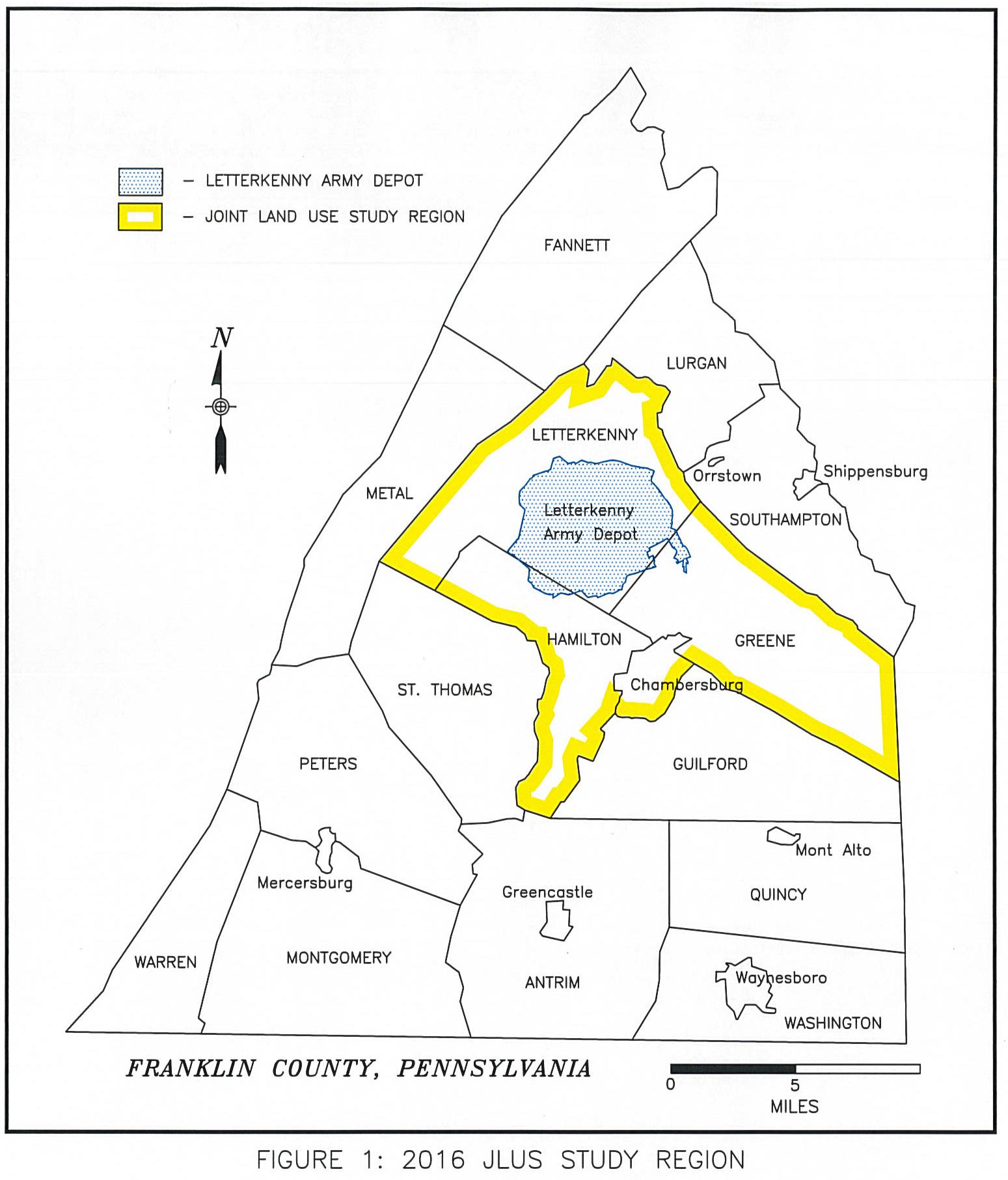
The study area for this report is considered to be a set of nesting geographic areas that include at the broadest level Franklin County; at the sub-regional level townships contiguous with the Depot (Greene, Hamilton, and Letterkenny, plus the Borough of Chambersburg – the nearest significant population node and the county seat) (see Figure 1); also at the sub-regional level, a variable distance based on the buffer of land surrounding the Depot grounds; and, at a micro level, specific parcels of land. These geographies have been employed variously as needed.
CHAPTER 2
Letterkenny Army Depot
History of Letterkenny Army Depot
During the early years of World War II the War Department began planning multiple large new ordinance depots to control and distribute the growing deluge of war materials. The sites were chosen based on their characteristics with regard to distribution. On December 18, 1941 the Secretary of War ordered the purchase of the land for what was to become the Letterkenny Army Depot. It was selected due to its proximity to the eastern seaboard and Washington, D.C., the nearby confluence of two major rail lines, adequate power and water, and the reputed work ethic of the people in the region. Construction commenced in early 1942 and the first shipments of ammunition arrived on September 23, 1942.
As may be expected, there was an element of public concern over the loss of nearly 21,000 acres of agricultural land and the displacement of some 1,000 residents. Actual objections abated rapidly, however, in the growing support for the World War II effort following the bombing of Pearl Harbor. The Letterkenny Army Depot, which derived its name from the Township from which the land came, would have the mission of reducing the surplus of forthcoming war material and storing and shipping ammunition, trucks, parts and other supplies.
The following is a brief outline of the years at Letterkenny Army Depot from its inception in 1942 to the current period. This history has been published by the Letterkenny Public Affairs Office.
“Construction began immediately with 798 underground igloos, 12 aboveground magazines and 17 warehouses. In 1956, an additional 104 igloos were constructed bringing today’s total to 902.
At the beginning, a large number of buildings were remodeled farmhouses, barns and chicken houses. The first shipment of ammunition arrived by train on September 23, 1942, three weeks ahead of schedule. More than three million tons of supplies were moved during the war years. As
men were called to service, staffing problems became acute. The depot drained the countryside of manpower needed for agriculture. Women, Commandos, Minute Men, even Italian prisoners of war filled the jobs. Regular employees worked 7 days a week and blitzes were common. With ingenuity and devotion, Letterkennians completed seemingly impossible tasks to keep ordinance material flowing constantly to 70 theaters of war. Letterkenny was one of the largest depots of its kind and was called the Springboard of Invasion in 1944.
After WWII, Letterkennians had hardly become adjusted to the idea that the war was over when they found themselves caught up in the new missions of peace. Even before these missions became official, combat vehicles began rolling into the depot for storage. An enormous amount of ammunition was being returned from overseas, some of which was unserviceable and had to be destroyed.
At the time of the Korean conflict, July 1950, Letterkenny Ordnance Depot was in much better condition to meet the emergency than back in WWII. However, the gears had to be shifted from peacetime drive to high war-time production and the work force swelled to 6,500 persons, with as many as 50 new employees coming each day. Letterkenny’s mission of receiving, processing, storing and shipping vehicles was strong. In 1946, experimental long-term dehumidified storage tanks were built to “can” or preserve vehicles. With the demands for ordnance materiel, the process was soon tested and deemed a success as vehicle after vehicle came out of the 169 petroleum storage tanks—all in excellent condition.
The 50’s were a time of growth as new technologies in electronics and guided missile maintenance increased the depot’s workload. Employees were trained in these fields and began working on NIKE missile components in 1953. Letterkenny became a pilot depot for the implementation of the Depot Command Management System and SPEEDEX (System-wide Project for Electronic Equipment at Depots Extended). In 1955, Major Item Supply Management Agency (MISMA), which provided control functions on a worldwide basis, became a tenant of Letterkenny. It evolved into the U.S. Army Depot System Command, Letterkenny’s immediate higher headquarters.
With the growth in operations came the need for expanded physical facilities. Renovation and the replacement of outdated machinery was needed to modernize some existing buildings, but major construction projects lead the way in the 1950’s to meet the depot’s new needs. Letterkenny became a permanent military installation on July 1, 1954. The ordnance depot was renamed Letterkenny Army Depot in August 1962, and command and control of the depot fell under the
U.S. Army Materiel Command. The 28th Ordnance Detachment relocated to Letterkenny from Fort Meade, MD in the 1960’s. With the war in Vietnam, Letterkenny’s missions increased.
In the 1970’s, command of Savanna Army Depot Activity, Ill. fell under Letterkenny. Although Letterkenny’s growth seemed to slow during the decade, the depot still played a vital role. An ammunition washout facility was built and the Northeast Area Flight Detachment moved to Letterkenny. The U.S. Army Depot System Command was established in 1976 and headquartered at Letterkenny. The 2-star command remained at Letterkenny until 1995 when it became the Industrial Operations Command at Rock Island, IL – today’s Operations System Command.
The 1980’s and early 1990’s saw the depot evolving into its present form. New facilities and modernization projects, such as the Automatic Storage and Retrieval System-Plus, were constructed. Letterkenny’s mission became three fold; supply, maintenance and ammunition. Paladin, PATRIOT and HAWK work made Letterkenny a Center for Technical Excellence. With the Department of Defense’s reorganization, Letterkenny’s supply mission moved to New Cumberland, PA under Defense Logistics Agency. In 2001, a smaller Directorate of Supply and Transportation was reestablished at Letterkenny.
Letterkenny’s future was reshaped in the 1990’s by the tactical missile consolidation and DoD’s downsizing, reorganization and realignments. The five-year Paladin howitzer upgrade partnership completed 950 Paladins in 1999 and artillery work moved to other depots.
In 2002, Letterkenny celebrated 60 years of supporting soldiers and the Army. The depot has unique tactical missile repair capabilities for a variety of Defense Department missile systems including PATRIOT ground support and radar equipment.
Comprising over 17,500 acres, a large land portion of the depot is used to conduct maintenance, modification, storage and demilitarization operations on tactical missiles and ammunition. The depot remains among the top three employers in Franklin County, PA fueling an economic engine that propels over ¼ billion dollars annually into the region through payroll, contracts and retiree annuities.
Since World War II, Korea and Vietnam, through Operation Desert Storm (Iraq) and Operation Just Cause (Panama), Letterkenny is proud to serve the soldier serving anywhere in the world.”
1995 Base Realignment and Closure (BRAC)
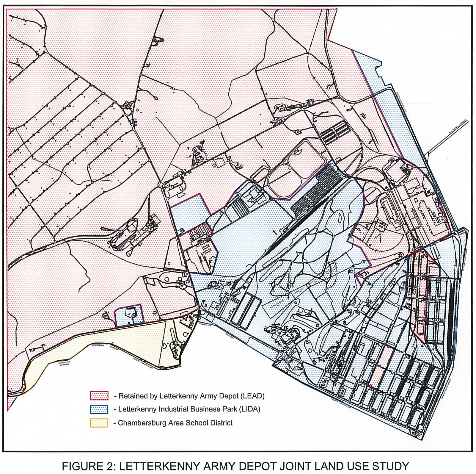
The Franklin County community responded to the 1995 Base Realignment and Closure (BRAC) decision by the Department of Defense to reduce the capacity of the Letterkenny Army Depot (see accompanying Figure 2). Approximately 1,460 acres of land with nearly 4 million square feet of buildings were considered excess property by the realignment. This also included the privatization of the electrical, water, sanitary sewer utilities, and the railroad system.
The Cumberland Valley Business Park
The Franklin County Commissioners established a 45-member committee of interested and skilled volunteers to begin the process of evaluating the property being disposed by the DoD. The Franklin County Reuse Committee considered the issues of transportation, business market, the environment, and quality of life issues during this process. The committee was aided by a team of consultants selected through a nationwide request for proposals. The consultants and the committee completed a detailed review of the property and prepared a strategic plan for the community to consider. Public meetings were held throughout the process to gain local insight into the development of the facilities. The Reuse Plan called for creation of a public authority to act as the agent to receive the Army property. The County Commissioners accepted the reuse plan, and created two separate public entities; the Letterkenny Industrial Development Authority (LIDA) to accept real estate and administer the electrical utility, and the Franklin County General Authority (FCGA) to administer the water, sanitary sewer and railway systems. A common staff of five professionals acts on behalf of both authorities, operating a modern, fully equipped, industrial development property known as “The Cumberland Valley Business Park.”
♦ John Van Horn, Executive Director of LIDA, contributed to the history of the 1995 BRAC and subsequent emergence of LIDA and the Cumberland Valley Business Park
The community began requesting property for reuse in 1997 through an interim lease from the Department of the Army. The establishment of private businesses within the Army Depot began. Faced by numerous challenges such as access, jurisdiction, and emergency response, the incoming industries teamed with the Letterkenny Army Depot to jointly address the needs of both parties.
Property Transfers Depend on Environmental Issues
To begin accepting property from the Department of the Army, LIDA utilized a Rural (no-cost) Economic Development Conveyance mechanism via a quitclaim deed. The first phase of property transfer took place in 1998 and included 233 acres of land and buildings. This property was transferred to LIDA with full protections from the U.S. Army, with concurrence from the Environmental Protection Agency (EPA) and the Pennsylvania Department of Environmental Protection (PaDEP) that any environmental issues were the responsibility of the previous owner and there would be no liability to the new owner. These covenants and protections allowed LIDA to sell and redevelop the property rapidly. The rationale for providing these covenants was that any soils issues were already addressed and that any remaining groundwater contamination would not be remediated on these specific parcels.
Subsequent to the Phase 1 transfer, the environmental regulators determined that the ground water remedy needed to be in place and operating satisfactorily before any additional land could be transferred. Concerned about delays in further transfers of property, LIDA immediately requested a review of the groundwater contamination in the large central district within the excess area that was underlain by Martinsburg Shale. Due to the impermeable properties of this lithology, it was doubtful that the area would be infiltrated by the nearby contaminated groundwater in the limestone formations. Eleven groundwater wells were installed and a twoyear sampling protocol began for this area.
At the same time, the community asked the Department of the Army to define the areas of the excess property that had no soil contamination but were suspected to be underlain by
contaminated groundwater. A comprehensive review of water level data for the previous 20 years was then undertaken by LIDA staff and consultants, which resulted in the establishment of reasonable, safe seasonal high groundwater table levels. These levels were used to establish that the property horizontally above this level was clean and transferable. The remaining property, below the seasonal high groundwater table, was accepted by LIDA in a lease in furtherance of conveyance until the groundwater remediation is completed.
This unique limited depth transfer method provided for the transfer of 327 acres of property (Phase 2) in May of 2002. Parcels were transferred to a safe depth of eight feet below existing grade to provide for construction and installation of necessary utilities. A considerable amount of the Phase2 property captured the nearly seven-mile network of paved roadways that served the Depot industrialized area. The transfer was preceded by a $4.2M project to upgrade the roadway and related storm water systems to municipal standards so that they could be dedicated to the local municipalities immediately after transfer. Subsequently, both Greene and Letterkenny Townships accepted the roadways and began maintaining them as public roads.
Upon sampling, validation, and review by the regulators, Phase 3 was ready for transfer. There were no findings of groundwater contamination under the Martinsburg Shale lithology, and public regulators were willing to provide similar protections and covenants for this 201 acres as for the first transfer of property. In April of 2004 this property was accepted by LIDA for immediate redevelopment free of any use restrictions.
During the year prior to the Phase 3 transfer, LIDA proceeded with master planning, parcelization, and proposed layouts of facilities within a 5 to 15 acre parcel mix to provide flexibility for the development of raw land in the Central “Hills” district. LIDA also invested nearly $1.5M in utility installation, including potable water, natural gas, and electrical and telecommunications conduits. The local community and the Commonwealth of Pennsylvania provided tax incentives to attract development to this area. Because there is no soil or groundwater contamination, the Phase 3 property is considered protective of human health and the environment and, as a result, is not restricted for any use.
In January of 2007 LIDA agreed to an amendment that would allow 243 acres of the allocated property to remain in the possession of the Army. The Phase 4 transfer was completed in September of 2010. LIDA received 61 acres located to the north of the Phase 3 area. The Phase 5 transfer was completed in March of 2014. LIDA received 83 acres consisting of numerous parcels in the Business Park that were not part of the Phase 1 and Phase 2 transfers. In April of 2014 LIDA agreed to another amendment that would allow the Army to retain an additional 103 acres.
To date, of the 1,400 acres declared excess by the BRAC decision of 1995, roughly 905 acres (65%) have been transferred to LIDA, 346 acres (25%) have been retained by the Army through amendments, and 149 acres (10%) are to be transferred at a future date.
Buildings develop faster than raw land
Since the beginning of community redevelopment within the excess area, LIDA has been fortunate to have considerable interest from local and regional businesses in expanding into the
excess depot facilities. Although plagued with low ceilings, inconvenient structural supports, and limited parking, the “bricks and mortar” of the warehouse area developed considerable interest for low-cost space. Bulk commodity storage filled the non-heated facilities and light manufacturing (woodwork and assembly) adapted to the heated warehouse buildings.
Office space renovations have drawn various companies interested in sharing the skilled workforce afforded by the adjacent Army Depot. LIDA continues to bring transferred facilities into code compliance and make “B” level renovations to meet market demand. Nearly $2M has been reinvested into “roofs, ramps, and rails” on various office and light industrial facilities within the park.
LIDA reached a milestone in 2005, a year with 100% occupancy resulting in no available existing facilities for sale or lease. In response, LIDA embarked on the development of the “Hills” area located on Opportunity Avenue in the center of the Cumberland Valley Business Park. Today, there are several new facilities with a limited number of remaining land parcels available in the “Hills”. Additionally, only one site remains in LIDA’s “Heartland” area which is bisected by Development Avenue. LIDA’s next logical step is the development of the 150 acres on Coffey Avenue known as the “Coffey Corridor”. This area offers the unique combination of economic incentives and a fully complemented infrastructure with roads and utilities. LIDA also manages the “400 Series” representing 150,000 square feet on 40 acres that offers business accelerator opportunities along with community benefit facilities. A current list of Business Park Tenants is shown in Figure 3.
56 VOLVO Road Machinery Road Machinery 1280 Superior Avenue
Warrior Roofing Manufacturing of PA
Manufacturer of Roofing products 323 Development Avenue
Woodland Equipment & Supply Co. Salt Distribution 821 Development Avenue
422, 424, 428
Wyle-CAS Group Defense Contractor 1425 Excel Avenue
Information contained herein is believed to be accurate but is not guaranteed or warranted in anyway whatsoever. It shall not be copied, reused or otherwise utilized in anyway whatsoever with the expressed written consent of the Letterkenny Industrial Development Authority. Information contained herein is subject to change without notice.
CUMBERLAND VALLEY BUSINESS PARK TENANTS
Figure 3
Utility development
As the excessed property has grown into a major regional industrial park, utility investment into unserved areas has diminished. The utility operational costs will stabilize and a defined customer base will be established. LIDA, responsible for the electrical distribution system, will create a reasonable business plan that quantifies the capital improvements necessary to operate a reliable utility. The value of ownership of the utility to facilitate economic development will decrease as the park is built out. LIDA may consider selling the system to an adjacent provider of this service as an addition to their service area.
In the future, similar considerations could be made of the water and sanitary sewer utilities, however it is anticipated that these services would be best provided under the current municipal authority structure (Franklin County General Authority) and need to provide for the existing and anticipated needs of the park. Also incorporated into the FCGA responsibilities is the leasing of the railway system to the Pennsylvania and Southern Railway as the park’s short line operator. The current long-term lease of the rail system provides for a reimbursement to FCGA. Therefore it is very probable that FCGA will continue to provide long-term services to the park tenants.
Jurisdiction and Land Use Controls
As the excess property transfers to the community, service provision is also transferred from the federal government to the jurisdiction of the Commonwealth of Pennsylvania and its municipalities to provide private property owners with emergency services and enforcement of traffic and related laws. Also, this jurisdictional change provides for local municipal oversight and control of land use for the parcels.
There are two local municipalities that encompass the transferred property. Approximately 75% of the park is within Greene Township and the remaining 25% is in Letterkenny Township. Of the two municipalities only Greene Township has existing land use controls (zoning) in place by ordinance. Currently the business park is considered a Heavy Industrial District, which allows for a mix of heavy industrial uses, light industrial uses, and highway commercial uses. This mix and flexibility provides for reasonable redevelopment of the park while respecting the adjacent land uses of the surrounding community.
The two municipalities have been very involved in the planning and subsequent transfer of property out of Federal jurisdiction and into the public domain. Both municipalities are cognizant of the importance of the realigned Letterkenny Army Depot to the local economy and quality of life. Each municipality has made every effort to work with LIDA and the incoming park tenants to assure proper protections to their constituency.
As property continues to transfer from the Department of the Army to the community and redevelopment of the park follows the market demand for the property, each municipality will be involved in the review process for the new construction. The requirement for building permits, subdivision plans, and land development plan approvals provide for community awareness and control of the park’s growth.
In yet another layer of protection for park tenants, LIDA established the Cumberland Valley Business Park Association (CVBPA) for oversight within the park. The CVBPA has adopted a
Declaration of Covenants, Conditions, and Restrictions (CCR), which pertain only to the tenants and landowners within the park. The CCR provides a structure to address permitted and prohibited uses, common area needs of the park, performance standards for operations, and design guidelines for facilities constructed within the park. The most noted restriction regarding land use within the CCR is the prohibition of residential use. This came as a result of the reuse planning and environmental review levels (industrial and commercial use) in anticipation of the first land transfer.
Military and Community
Since the BRAC 1995 decision, many changes have taken place that have caused the military and the community to resolve challenges and provide solutions to problems never anticipated. The ongoing military mission and environmental remediation of the excess property has affected the timetable for land to be transferred to the community. Market demand for available raw property varies as global markets change. Force protection requirements for Department of the Army facilities result in the need to develop secure military compounds within public areas while maintaining vehicle access to private property. Addressing these requirements is an on-going challenge for the Army. When feasible, a municipal or regional police force would reduce the Business Park’s reliance on State Police coverage. The significant expansions to military missions in the past decade have required the community to be flexible and adjust their business planning by providing certain excess facilities needed once again by LEAD. A significant partnership has evolved between the military and the community to address the changes that are inevitable.
Military Operations and Missions at LEAD and LEMC
LEAD aggressively pursues new missions to support joint service operations for the conflicts in the Middle East, the Global War on Terrorism, and Homeland Defense initiatives. The following are some of the military operations and missions currently being undertaken at LEAD:
Patriot Recap
The Patriout Recap provides sevices for Tactical Missile Maintenance, Modification and Integration, and possesses the specialized capabilities that support Total Weapon System Maintenance, from the manufacturer to storage, certification, GSE rebuild, CONUS and OCONUS support, to final demilitarization. Radars, Launchers, Communication Relay Groups, Engagement Control Stations, Information Control Centrals, and Antenna Mast Groups are serviced as part of this mission.
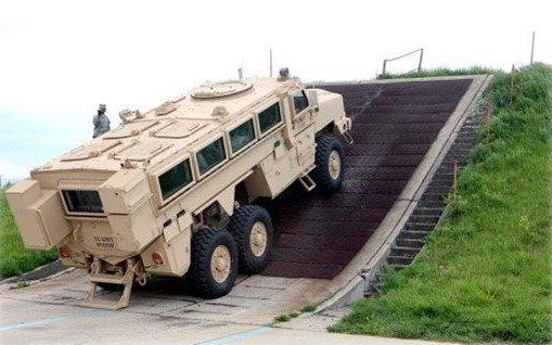
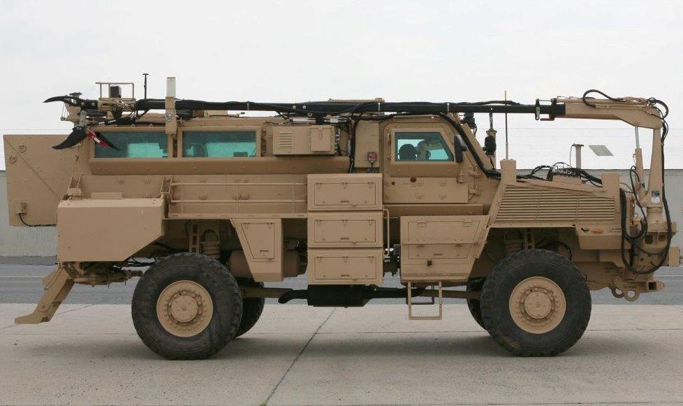
Route Clearance Vehicles
LEAD currently performs fleet repair and modernization for various types of Route Clearance Vehicles including the Buffalo/MPCV, a mine-hunter clearance system; the VMMD “Husky” System, a mine detection and detonation system; the RG 31 MMPV, a blast-protected protection
platform; the MMPV Panther, an ambush protected command and control platform; and the JERRV, used in neutralizing IEDs, mines, and other ordinance.
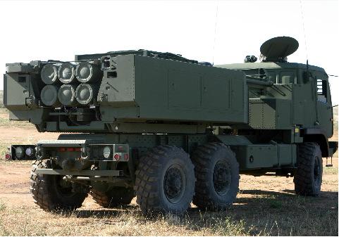
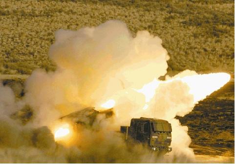
High Mobiliity Artillery Rocket System
HIMARS is a light multiple rocket launcher mounted to an FMTV. LEAD is currently overhauling various system components as well as conducting equipment testing in support of Marine and Army requirements.
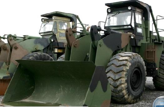
Material Handling Equipment
LEAD works closely with the National Guard Bureau and has the capabilities to perform total vehicle rebuilds. Vehicles include 7.5-ton cranes, 4k forklifts (ATLAS), 6k forklifts, 10k forklifts (ATLAS), and 5 cubic yard scoop loaders.
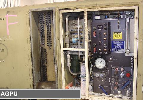
Aviation Ground Power Units (AGPU)
The AGPU is designed to provide electrical, hydraulic, and pneumatic servicing of rotary-wing aircraft.
LEAD is the AGPU Reset “Gold Site” and provides complete overhaul services, direct support, final handoff inspections, new equipment training, and complete testing of all assembles and assets.
Generators
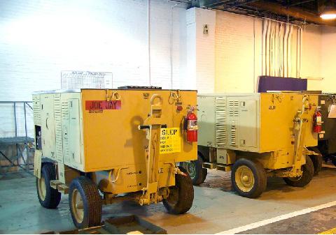
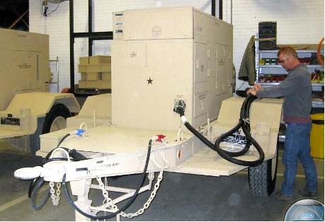
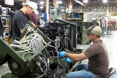
Power generation provides electricity to meet mission infrastructure needs for soldiers and civilians at home and abroad. LEAD is the “Center of Technical Excellence” for Tactical Quiet Generator (TQG) repair/overhaul., servicing 54 variations of skid and trailer mounted generators. The TQGs are rugged and can be operated under extreme environmental conditions.
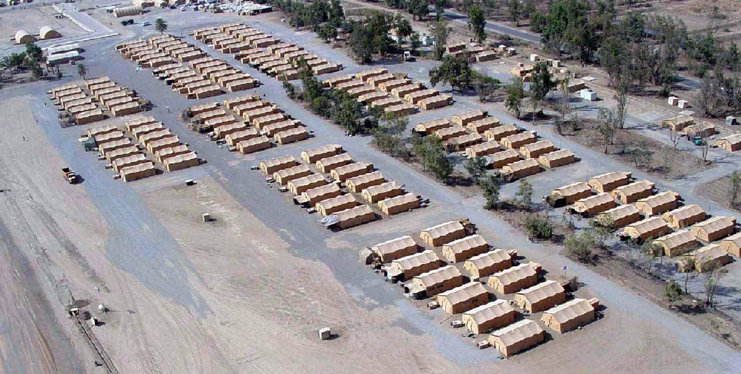
Force Provider Systems
Force Provider is invaluable to the morale and welfare of joint service troops deployed in a combat zone by providing climate-controlled billeting, latrine, shower, laundry and welfare facilities to the forward deployed Soldier. LEAD has the capability to build new modules as well as rebuild/refurbish complete systems.
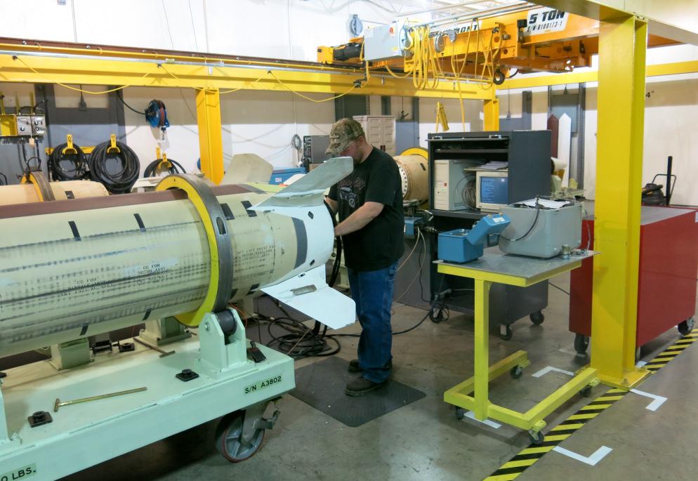
TOW Component Repair
The TOW is a wire-guided line-of-sight heavy anti-tank missile used in anti-armor, anti-bunker, anti-fortificaiton, and anti-amphibious landing roles. The TOW missle system has been in service since 1970. LEAD has been overhauling and resetting the TOW Ground and TOW Bradley systems and secondary components since 1994.
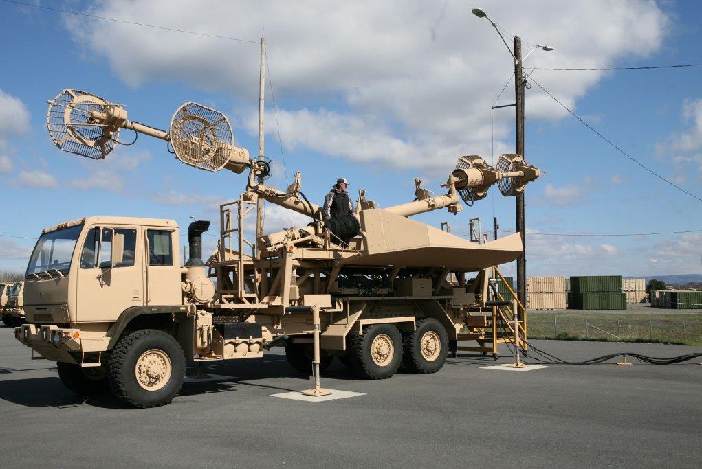
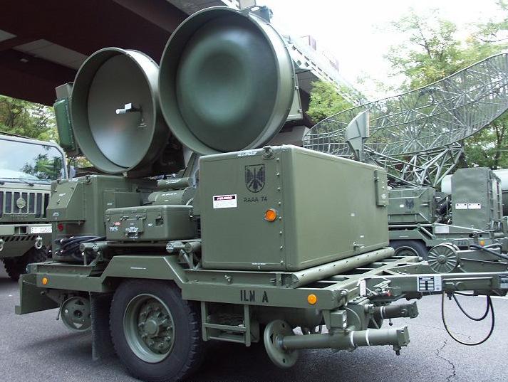
Hawk and Patriot Radar Systems
The Depot also “reconditions” and tests various radar systems, the most current being the Hawk and Patriot Radar systems. LEAD is one of only two sites in the United States that has an FCC license to live-radiate these radar systems.
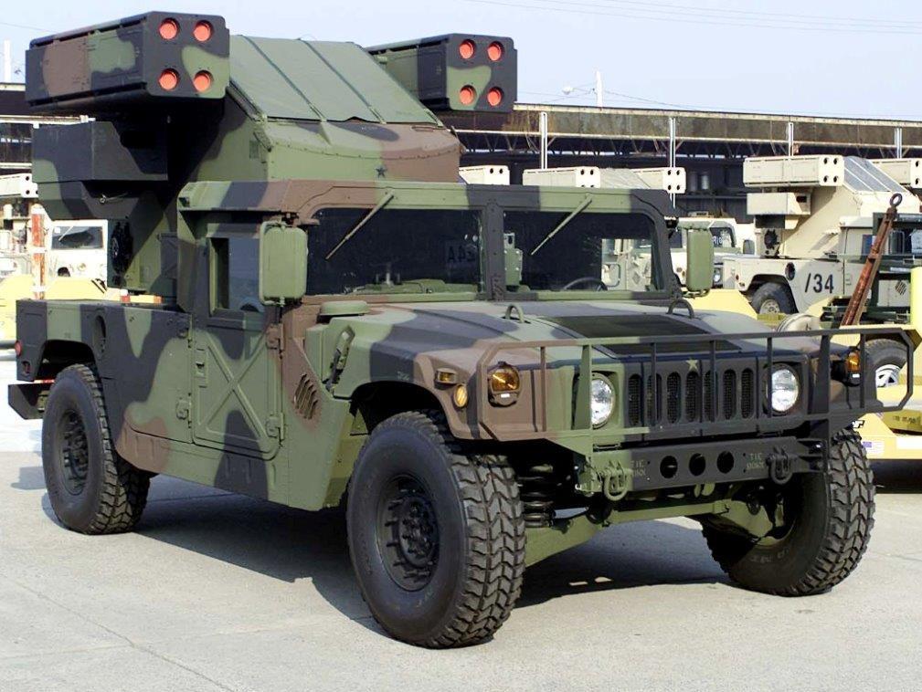
Avenger Overhaul
The Avenger Air Defense System is a missile system which provides mobile, short range air defense protection for ground units against cruise missiles, unmanned aerial vehicles (UAV), low flying fixed winged aircraft, and helicopters. LEAD has provided Avenger Depot Level Maintenance and total fleet maintenance of all Avenger variants to the Army, Army National Guard Bureau, Marine Corp, and Foreign Military customers since 1992.
Letterkenny Munitions Center (LEMC)
Located on 16,000 acres in the Depot, LEMC is the Army’s East Coast Power Projection Platform for munitions and is responsible for conducting regional and global distribution of munitions, missile maintenance, and demilitarization of munitions for joint forces and international partner nations. LEMC also provides Centralized Ammunition Mangement for training ammunition and contingency stocks for Army units in the Northeast region. Currently over $9 billion in joint munitions are stored on the Letterkenny Army Depot. LEMC is the Army’s only depot for the Army Tactical Missile System (ATACMS) and Guided Multiple Launch Rocket System (GMLRS), and supports some of the most advanced Air Force and Navy
missile systems. LEMC was named Center for Technical Excellence for Multiple Launch Family of Munitions in 2016.
Army Reserve Operations at Letterkenny
The 99th Regional Readiness Command (RRC) runs Army Reserve operations in Pennsylvania, West Virginia, Virginia, Maryland, Delaware and Washington, DC. The command is comprised of 185 units and more than 20,000 soldiers. The 99th RRC has an annual budget of more than $70 million dollars and is responsible for over 200 facilities including Army Reserve Centers, Army Maintenance Support Activities, Equipment Concentration Sites, local training areas and air support facilities.
Biological Integrated Detection System (BIDS)
A sheltered, biological detection laboratory mounted on a High Mobility Multipurpose Wheeled Vehicle (HMMWV), the BIDS system is equipped with air sampling detection and identification equipment. Within 30 to 45 minutes, the two soldiers operating the BIDS can presumptively identify a suspected biological agent and warn soldiers in the corps' area of operations to take
appropriate action. It consists of seven sampling and detection items, along with navigational devices, weather sensors and communication links.
Environmental Review
General activities at the Depot since its establishment in 1942 have included ammunition storage, overhauling and rebuilding of wheeled and tracked vehicles, maintenance, demilitarization and modification of ammunition, and open burning and open detonation of munitions and explosives. Some of these activities involved the use of trichloroethylene, other solvents, lubricants, corrosives, and various metals. Various industrial operations included cleaning and stripping, plating, lubrication, chemical, and petroleum storage and transfer.
Prior to construction of the Industrial Waste Treatment Plant and storage lagoons, runoff from the various industrial areas was collected in storm drains and would have been carried off-site through stormwater drainage channels. Prior to the use of burn pans in the Open Burning Area, burning operations were conducted on ground. Open detonation, due to the nature of the activity, is conducted in ground, resulting in the disturbance of large areas of soil.
This environmental section of the JLUS report briefly discusses the various activities, the areas where they occurred, off-site contamination that has resulted from these operations, and the various environmental remediation activities conducted by LEAD, past, present and future.
Information for this section of the report was provided by the Pennsylvania Department of Environmental Resources in the Waste Management, Environmental Clean-up, Water Management, and Air Quality Programs.
Various staff members were also interviewed from LEAD environmental offices and the Letterkenny Industrial Development Authority (LIDA).
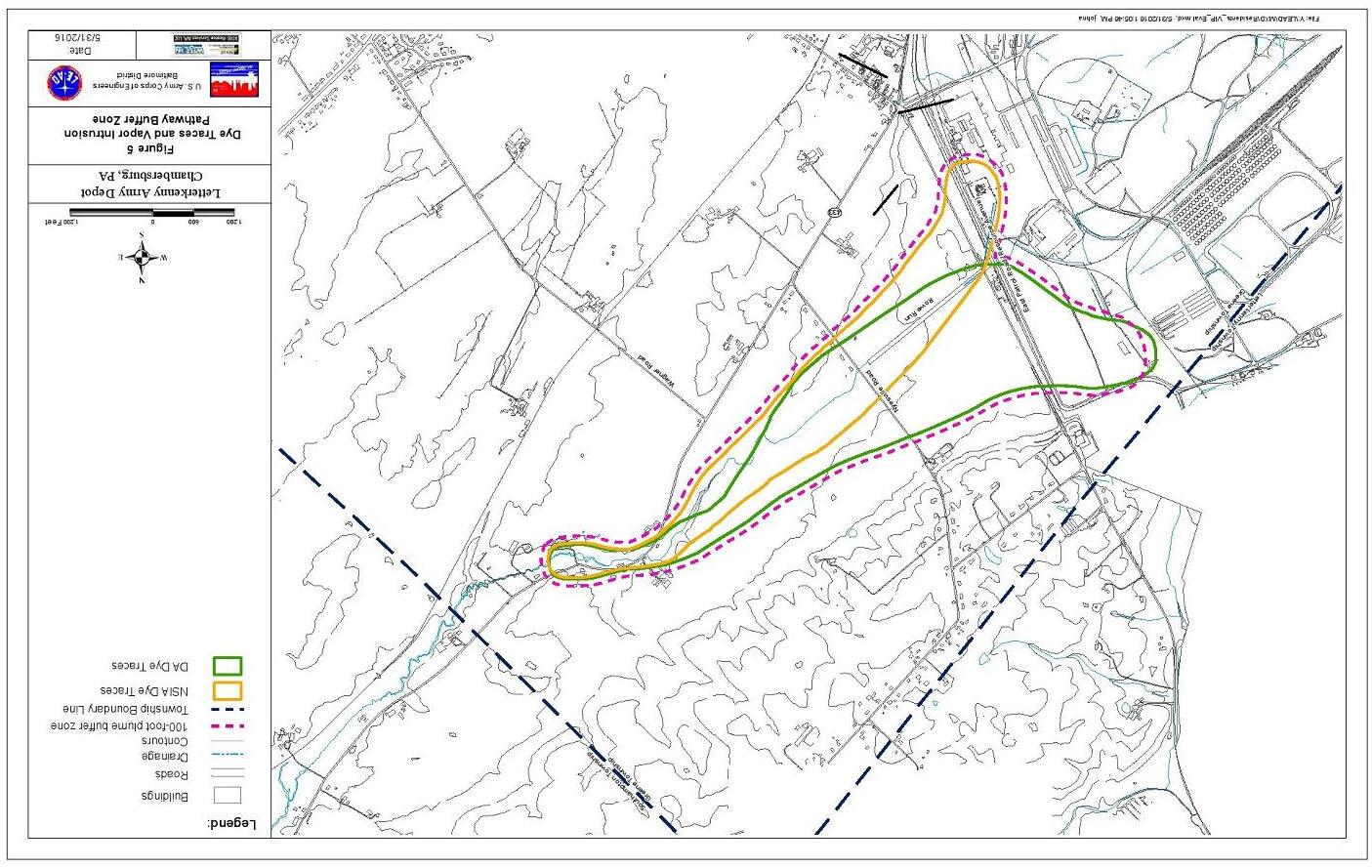
The attached Figures 4 and 5 illustrate the Current Layout of Groundwater Operable Units (OUs).
1. Industrial Waste Treatment Plant (IWTP) and Facilities.
A one million-gallon unlined lagoon was constructed as part of the IWTP between 1954 and 1957. In 1967, leakage was detected from the lagoon. The lagoon was excavated and replaced with two concrete lined lagoons. Cracks were discovered in these lagoons in 1986. Use of the lagoons was totally discontinued in 1988.
The activities of the IWTP and lagoons caused off-site groundwater contamination to the East and Northeast of the Depot (SE OU 11). The underlying geology of the site, as well as off the Depot, is limestone. Limestone is prone to sinkholes and solution channeling, making groundwater recovery and treatment very difficult.
All areas utilizing well water supplies that exhibit contamination above the maximum concentration levels (MCL) have had public water (Guilford Water Authority) extended into those areas to serve homes. Additionally, other homes without contaminated wells along the line have been able to connect to public water.
During the early 1990’s the IWTP lagoons were closed, VOC contaminated soils were excavated, thermally treated, backfilled, and capped as required under the RCRA and
CERCLA hazardous waste closure requirements of EPA and the PaDEP. Contaminated soil has been removed from storm drains with follow-up confirmation sampling.
Solvents are no longer discharged to the IWTP. Wastes previously stored in the lagoons are contained in the various process tanks. The wastes are pumped out by a hazardous waste contractor and hauled off-site for proper treatment and disposal. Various other hazardous wastes produced at the depot are stored in roll-offs or drums and are also picked up and hauled off-site by the hazardous waste contractor.
The Phase 3 property was transferred in 2004 with no environmental restrictions. The Phase 4 property (SE OU 3A area) was transferred to LIDA in 2010. The remaining portion of SE OU 10 (Phase 5) was transferred in 2014. LEAD conducted “enhanced bio-remediation” of the groundwater in this area in 2005 and continues to monitor the groundwater. The results of the monitoring have not shown a decrease in contaminant levels in the SE OU 10 area.
a. SE OU 3 / SE OU 11 – areas on the depot.
SE OU 6 – area off-depot in the Rowe Run area Further groundwater investigation is continuing in these areas to determine the vertical delineation (depth) of contaminants. Additionally, as a result of the potential for seepage of volatiles into homes in the Rowe Run and Rowe Spring area, vapor intrusion investigation will be conducted by LEAD in the latter part of 2005. If vapor intrusion is discovered in homes, radon-type venting systems can be installed.
b. PDO OU2 – Southern area
(Rocky Spring Area and Rocky Spring Lake)
Groundwater flow is in a southwesterly direction off-site. Although there currently is groundwater contamination on-site, there is no contamination offsite. LEAD is conducting on-going groundwater monitoring off the depot including the Rocky Spring Area and Lake.
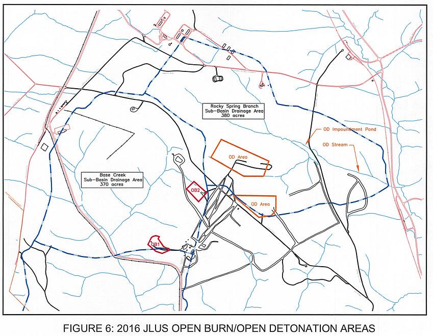
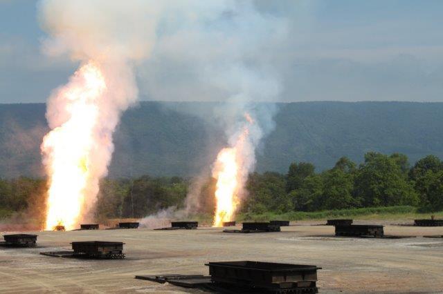
2. Open Burning / Open Detonation Areas (OB/OD)
The OB/OD areas were constructed in 1945 and have been in operation since that time. OB activities are conducted in burn pans, burn cages, or rocket motor static firing tubes. After treatment the areas are inspected, residues are then collected and treated or disposed of at the next burning. See Figure 6.
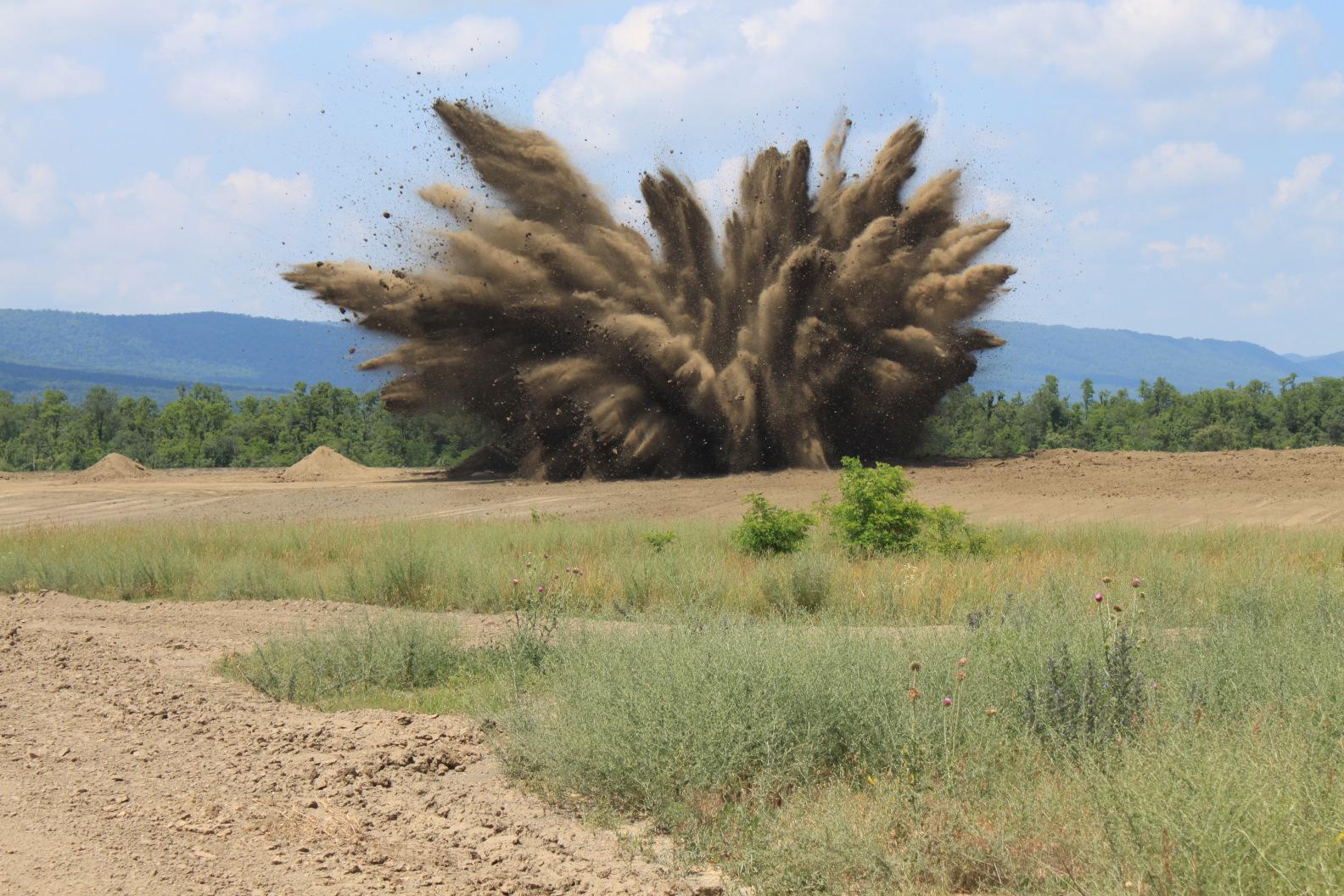
OPEN DETONATION
OD activities are conducted in-ground. Contaminants from these activities may be released through runoff, or erosion into surface waters, or in groundwater. Contaminants may also be emitted directly into the air. However, there has been no indication that contamination release, if it does in fact occur, is in excess of allowable standards.
LEAD conducted a groundwater-sampling program in 2001, which indicated that concentrations in the samples were below the MCLs for groundwater protection. No explosives were detected in the groundwater samples. Although the results indicated that groundwater has not been impacted, LEMC maintains an on-going groundwater monitoring program. Nearby wetlands have been delineated in order to maintain adequate isolation distances from activities.
OB Area – additional controls include diversion of surface water run-on, down gradient diversion dikes, silt fences and sediment traps.
OD Area – sedimentation impoundment is used to trap and collect sediment down gradient of the OD area. An NPDES permit for stormwater discharge from the basin has been issued by PADEP and will be monitored by LEAD. Additional controls included revegetation of portions of the area, reduction in size, buffer zones, and berms to reduce erosion and sediment runoff.
SUMMARY OF ENVIRONMENTAL REVIEW
On-going environmental issues that have impacted areas off base include groundwater contamination from the closed hazardous waste lagoons and potential for vapor intrusion from volatile organics into homes and buildings. Public water has been extended into these areas, and groundwater remediation is on-going. Additional studies and remediation efforts will be conducted to further identify and reduce the contamination plume and determine the potential for vapor intrusion.
Soil erosion and sediment run-off from the OB/OD areas have been controlled as described in the discussion on the OB/OD areas such as the installation of a new sedimentation basin, reduced detonation area, size limitations for detonations, etc.
Occasionally a complaint is registered resulting from the open detonation of munitions at the Letterkenny Army Depot. LEMC maintains a hotline to address these complaints and closely monitors environmental conditions in order to minimize noise and vibration during detonation periods. The number of annual complaints have been reduced from hundreds to less than 30 per year. Additionally, a multi-million dollar project for enclosed disposal of rocket engines is underway at LEMC. The target date to bring this new facility online is November of 2016. This
facility will essentially eliminate offsite impacts from rocket engine disposal in the future. However, current programs will generate the need for open detonation far into the future. If the residential land adjacent to LEAD is developed into residential or commercial properties, there could be noise issues in the future.
Off depot noise and vibrations from activities conducted in the OB/OD area are expected to continue. LEMC has attempted to control off-site noise by following restrictions based on weather conditions as described. LEMC maintains an on-site weather station to provide more accurate weather conditions. LEMC is permitted a maximum explosive volume of 500 lbs per open detonation.
There is a continuous and well-documented record of rapid and effective response to environmental issues. Examples include:
• The Phase 3 property was transferred with no environmental restrictions.
• The Army removed contaminated soil and installed monitoring wells on the Phase 3 Parcel in order to environmentally clear the parcel for subsequent transfer in January 2004. Environmental investigation cleared both the groundwater and soil for unrestricted reuse.
• SE OU 3, 6, 11 – Vapor intrusion studies were completed in 2007/08 and resulted in no human health concerns. Currently Letterkenny is in the middle of conducting another round of vapor intrusion samples. Risk assessment of these samples has not been finalized yet.
• PDO OU 2 – Letterkenny conducts annual groundwater monitoring as part the remedy for PDO OU 2. Recent sampling confirmed that there still is no offpost contamination in the Rocky Spring Lake area.
• IWTP Lagoon/K Area Lagoon - The Army is finalizing the Record of Decision (ROD) for the IWTP Lagoon groundwater (SE OU 11) and the K Area Lagoon groundwater (SE OU 3). Proposed remedy is in-situ chemical oxidation using potassium permanganate. ROD will be signed by the end of FY 16. The groundwater remedy will be implemented by the Spring/Summer of 2017.
• In-situ enhanced biodegradation – I am assuming this referring to the SE OU 10 groundwater (Building 37). Letterkenny continues to monitor the groundwater on an annual basis. Only wells in the immediate vicinity of Building 37 are above MCLs.
• Lot 48 – Lead contaminated soil removal was completed in 2002.
These and other environmental activities on the part of LEAD have validated a sense of responsiveness and the perception of appropriateness in the community as a whole.
CHAPTER 3
The Study Area, Economic and Demographic Trends and Projections, and
Sub-Regional Land Use
The Study Area
The specific physical features of the four-municipality study area would indicate that the actual area impacted by the Letterkenny Army Depot is somewhat less than the total area of the four municipalities. The northwestern boundary of the Depot is bordered by Broad Mountain, which offers a natural and significant topographic buffer area. This section of Broad Mountain is heavily forested, and the majority is designated as State Land.
The lands to the north and east are mainly used for agricultural purposes. The majority of the soils in these areas are considered Prime Agricultural Soils, and, to date, six farms totaling over 900 acres have had their development rights purchased via Franklin County’s or other private agricultural conservation easement programs. The small villages of Upper Strasburg and Pleasant Hall are the only residential communities located within these agricultural areas. A small number of farms and residences are scattered along State Routes 553 and 997, which run along the Depot’s northern and eastern borders.
The southern boundary of the Depot is bordered by State Game Lands #235 and sparsely populated, largely agricultural land. The only residential area directly adjacent to the depot in this area is the village of Cheesetown. The Borough of Chambersburg is located further south and is a significant population center.
The Cumberland Valley Business Park is located on former Depot land to the southeast of LEAD and is designated mainly for industrial use. Residential uses are prohibited within the confines of
the Cumberland Valley Business Park, and it subsequently serves as a buffer for activities at the Depot. The villages of Culbertson and Greenvillage are located to the southeast of the Depot and the industrial park.
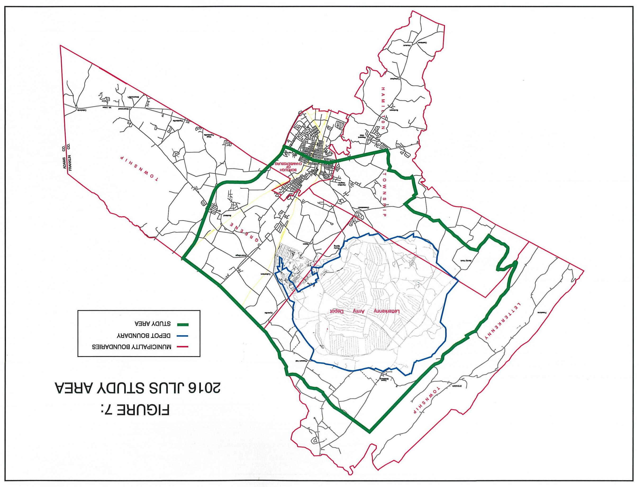
The 19,500-acre Depot itself is bounded to the northwest by mountainous state forest and game lands, while the areas to the north, south, east and west exhibit a decreasing impact with linear distance. As is illustrated on the accompanying Figure 7 entitled, “JLUS Study Area,” the impacted area is as follows:
• To the north a logical geographic boundary for the sub-regional study area would be northerly municipal boundaries of Letterkenny and Greene Townships.
• To the east, the potential impact from Letterkenny Army Depot diminishes to nearly zero at Interstate 81.
• To the south the Borough of Chambersburg and the Township of Hamilton are only significantly impacted in the areas north of Route 30. Based on the above geographical reasoning, this study has reduced its focus to the outlined area.
Population Growth
Historically Franklin County has had a growth rate somewhat less than the United States as a whole, but a significantly faster rate than that of Pennsylvania. The recently completed report prepared by Shippensburg University and entitled “The Economic Impact of Letterkenny Army Depot in Franklin County, Pennsylvania” characterized the population patterns as follows:
“The county grew by 15.7% between 2000 and 2010 to 149,618, with subsequent Census Bureau population estimates (153,696, 2015 est.) showing that growth continuing. This growth played a role in transitioning the county from a micropolitan area to Census Bureau defined Metropolitan Statistical area in 2013. Two projections each show this growth continuing at least through 2025 to 2040 and placing it among the 15 fastest growing counties in the state. The more conservative Pennsylvania State Data Center projection forecasts a population of 173,765 in 2040. This growth is consistent with other counties in the wider area of south-central Pennsylvania and ranks the county among the fastest growing in the state.”
FIGURE
8
Source: Franklin County Comprehensive Plan, June 2012
As illustrated in Figure 8, the population of Franklin County as a whole has grown significantly since 2005, rising from under 130,000 to 149,618 in 2010.
FIGURE 9: TOTAL POPULATION 1960-2010
Source: U.S. Department of Commerce, Bureau of the Census
Figure 9 illustrates the population characteristics of the four municipalities under study. It is clear from reviewing this data that growth is occurring at a greater rate in Greene and Hamilton Townships and the Borough of Chambersburg than the more rural, minimally developed Letterkenny Township.
A unique characteristic of the population within the study communities is exhibited in age composition. This characteristic exhibits itself throughout Franklin County and in the four municipalities and is the subject of the Shippensburg University report, which comments on the age composition characteristics of Franklin County as follows:
“Franklin County is distinctive for having a much higher Age Dependency Ratio than Pennsylvania and the country at large. The county’s ratio is 68.9 (29.4 for the old age dependency ratio, and 39.5 for the child dependency ratio). For the United States the numbers are 59.3 (21.9,
27.4) and for Pennsylvania, 59.9 (25.6, 34.4), respectively. In other words, the county simultaneously has higher proportions of people who are older (65 and above) and younger (0-17), relative to those aged 18-64. This number is also much higher than nearly all surrounding counties, which largely resemble the numbers for the state.”
The aging characteristic of Franklin County’s population has interesting and much discussed economic impacts. For the purposes of this Land Use Study, however, certain other conclusions may be drawn. Specifically, this “gray” population may well be attracted to Franklin County because of the Pennsylvania state tax structure and its proximity to the large metropolitan areas of Baltimore and Washington, D.C. In the mid-2000s the housing market in Franklin County expanded dramatically. This expansion was significantly curtailed when the market collapsed in 2008. However, the county’s population has continued to increase more rapidly than most other parts of the state. In any event, it can be expected that the area of developed land within the study area will expand to some degree. As this expansion occurs, it can be concluded that an increasing number of Franklin County residents will be living within the area of influence of the Letterkenny Army Depot.
Economic and Demographic Trends and Projections
The study area for this joint land use study is comprised of Letterkenny Township, Greene Township, Hamilton Township and the Borough of Chambersburg. These areas encompass some 170 square miles and a residential population of over 50,000 persons.
The historic perspective tells us that this portion of Franklin County, along with a wider multicounty area in both Pennsylvania and Maryland, has been and remains a predominantly
agricultural community, with the significant non-residential development concentrating in the Borough of Chambersburg. During the last several decades growth has occurred in an outward direction from Chambersburg along the major traffic routes to the west and north in Hamilton and Greene Townships. These townships are gradually transforming themselves into suburban, bedroom communities. Letterkenny Township, however, due to its physical distance from the major population concentrations and transportation routes, and the lack of available central sewer and water, has remained predominantly agricultural.
Non-residential development initially and historically occurred largely in the borough, but in the past decade has associated itself almost exclusively with Route 30 and Interstate 81 and, to a lesser degree, Route 11. Employment opportunities have in recent years grown significantly in the logistics and distribution sector, stimulated by the regional location of the Franklin County area, the growth of activity on Interstate 81, and the existence of the intersection of two major railroads in Chambersburg.
The industrial and business development occurring in the Cumberland Valley Business Park under the direction of LIDA represents one of the few examples of business and industrial development occurring in a location not directly associated with the major transportation routes in the county.
The recently completed economic impact analysis prepared by the Center for Land Use and Sustainability at Shippensburg University studied the potential impact of the closure of Letterkenny Army Depot and attempts to frame the local and regional significance of the
economic linkages between the Base and the Franklin County economy. The study pointed out that the Depot is directly responsible for some 2,700 jobs, and tangentially responsible for an additional 3,600 jobs. These jobs account for approximately 8.1% of employment in Franklin County. The total monetary value of LEAD is estimated at $495 million dollars (8.5% of the total county value). Additionally, economic activity generated at the Letterkenny Army Depot acts to:
1) Reduce the out migration of people in their most productive years, thereby slowing the trend toward a disproportionately “gray” population.
2) Slow the shift of industry and employment toward a greater percentage of low wage jobs and adds training opportunities, which expands human capital and enhance employment productivity.
3) Reduce the local trend toward a declining average wage pattern
4) Keep residents’ jobs in the county, reducing the degree to which Franklin County has become a net exporter of employees.
5) Provide an employment structure in the manufacturing sector in the face of the county’s increasing service and retail oriented economy.
It is largely acknowledged by the community’s leadership that the Letterkenny Army Depot is a spur to many aspects of the local economy ranging from personal income and gross regional product, to supporting a more youthful demographic trend. The report prepared by the Center for Land Use at Shippensburg University concludes:
“Letterkenny Army Depot has a long and important past within the Franklin County community from an economic standpoint and arguably for a social and cultural standpoint as well. The highly skilled workers at the base have long formed a key component of the region's labor force As we noted in a similar study a decade ago, the base not only provides the region with solid jobs, but indirectly with workforce training and links with other industrial sectors. The central position of LEAD in the community
has been clearly expressed over the years in the changes that have occurred relative to various fluctuations in base operations have also been felt in the larger community ”
“In sum, we found that the base is associated with more than 8% of both county employment and value added. Net earnings would drop substantially across the region and the area would likely suffer substantial labor force and population declines. Importantly the loss of both the general population and the labor force would fall most heavily within the younger and mid-career cohorts - typically those with significant skill sets. The community at large would suffer measurable property value declines with a loss of base operations, an impact that would affect both those directly associated with the base as well as others.”
CHAPTER 4
Existing Land Use
in Potentially Impacted Area
Definition of Impacted Area
The study area and its geographical configuration have been illustrated earlier in the report on Figure 7. As discussed earlier, the impacts that may be felt from activities at the Letterkenny Army Depot and, vice versa, impacts from land development impacting on the activities of the Depot are constrained to a geographical area where distance acts to bring actual perceived impacts to at or near zero along the perimeter of the defined study area.
Existing Land Uses
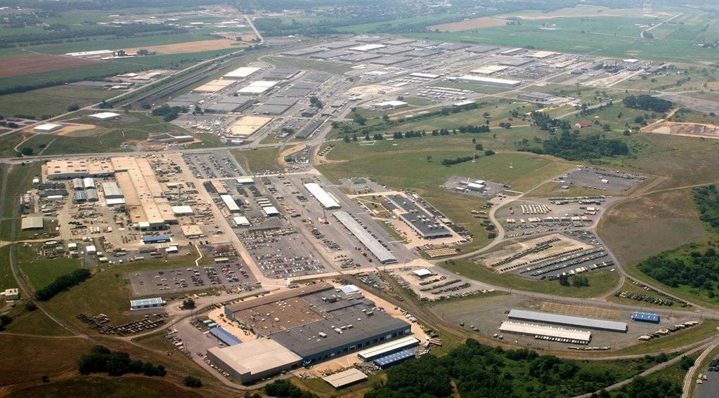
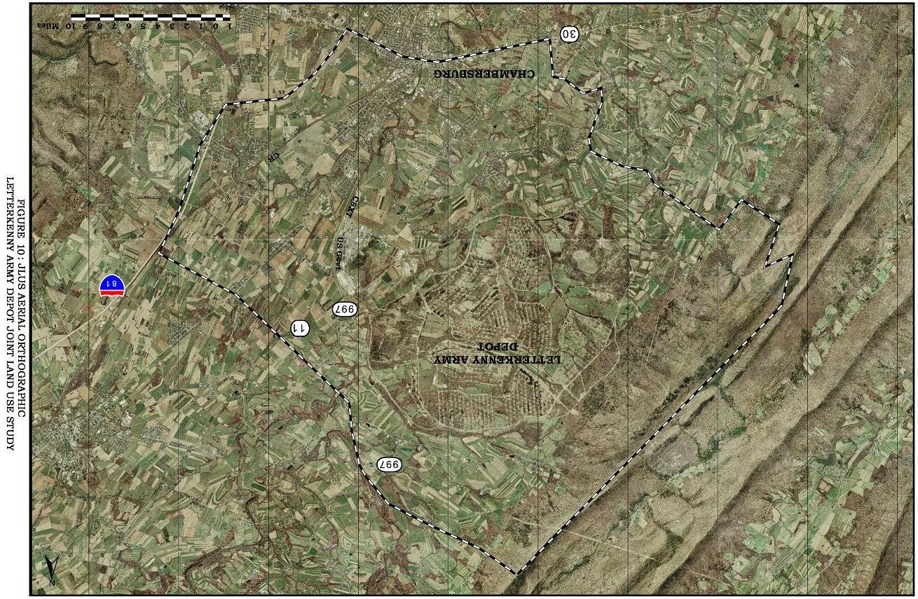
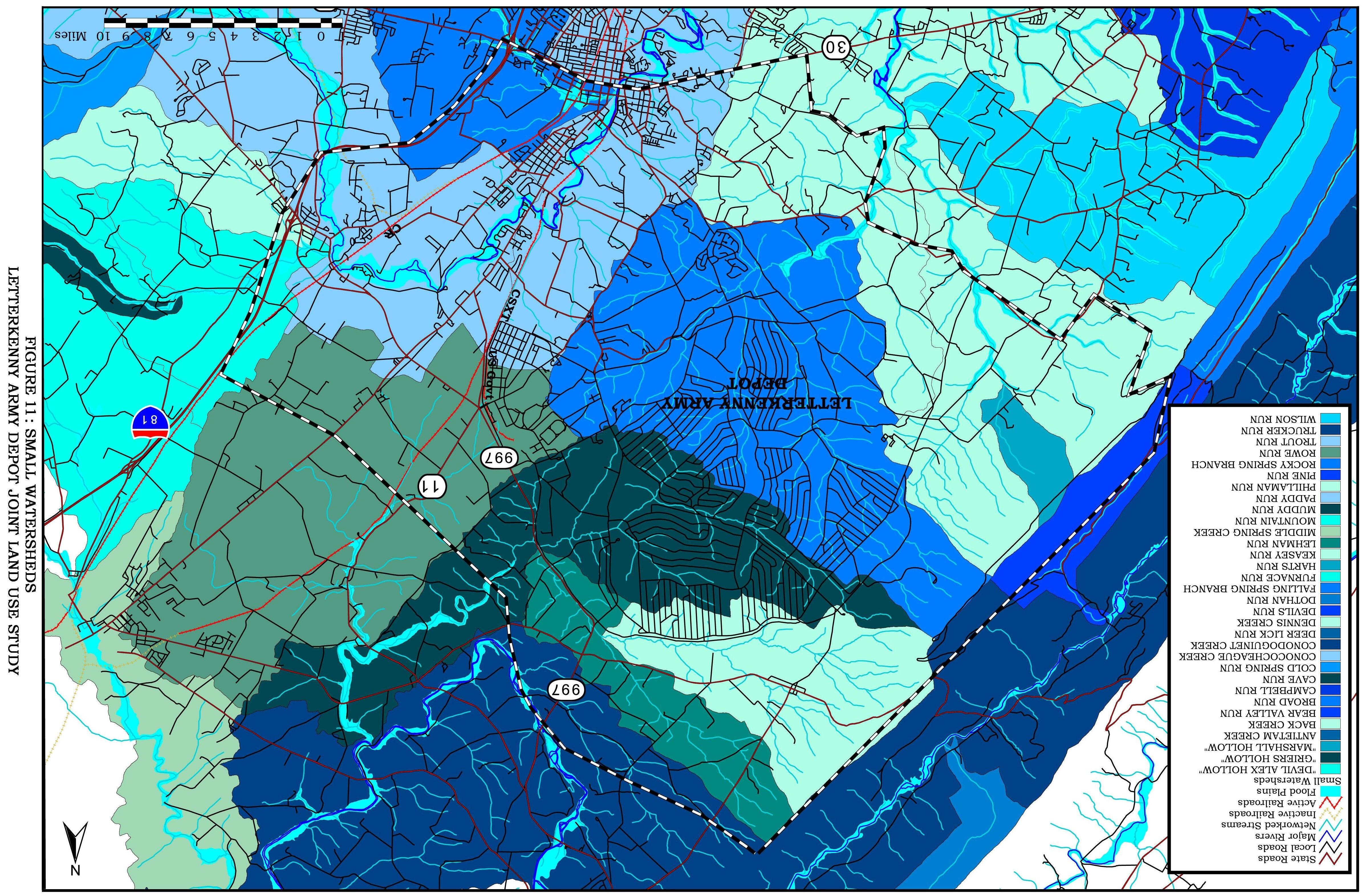
An analysis of existing land uses within the study area and surrounding Letterkenny Army Depot was conducted. Figure 10 shows an aerial photograph mosaic of the Depot and surrounding area. Publicly available data was analyzed and used to create mapping for agricultural areas, watersheds, geologic conditions, flood plains, streams, and roadways (see Figures 11 and 12).
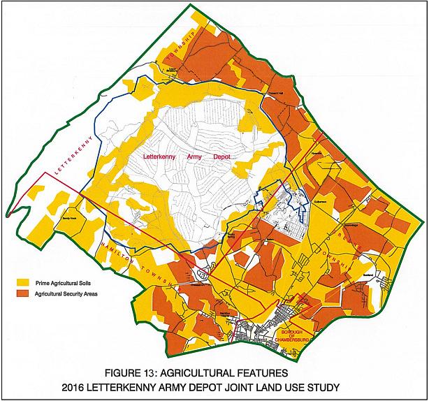
Mapping from the Townships and Franklin County Planning Commission provided the basis for the illustrations of prime agricultural soils, agricultural security areas, and land preserved by agricultural easements. It is the land use assumption of this analysis that the prime agricultural soils and the soils that are encompassed by some form of agricultural preservation are usually the least likely and last to be developed. Figure 13 illustrates these agricultural features and to a large degree shows that vast portions of the study area will be slow to develop in the context of the assumption that prime agricultural land will remain viable for agricultural purposes for longer periods of time than lands with less desirable agricultural characteristics.
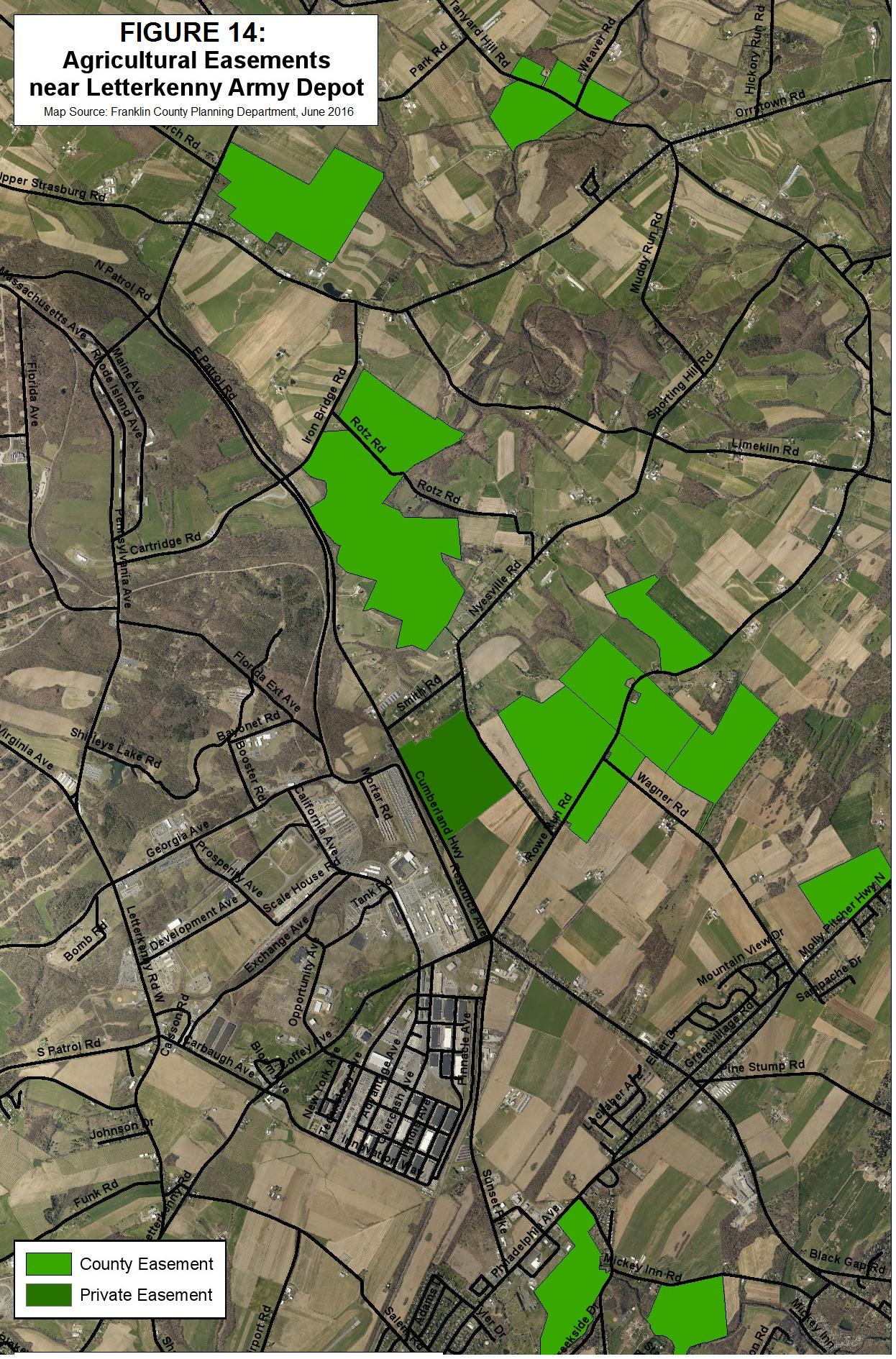
Figure 14 shows farmland in the vicinity of the Depot that is preserved through private and County agricultural easements, making this property unlikely to develop for other uses.
Additionally, a large area of State Forest Lands exists along the entire northwestern boundary of the study area as illustrated on Figure 15.
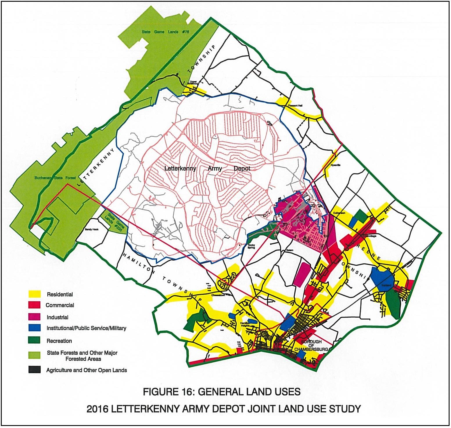
The result of the land use analysis discussed above and illustrated on the attached illustrations are summarized on Figure 16, which graphically illustrates the general land uses existing in the study area surrounding the Letterkenny Army Depot. Much open space is available and as pressures for residential developments grow, it can be expected that the land use pattern will change from agricultural to residential. The exception to this expectation is the Cumberland
Valley Business Park, which can be expected to grow and fill in with business and manufacturing uses.
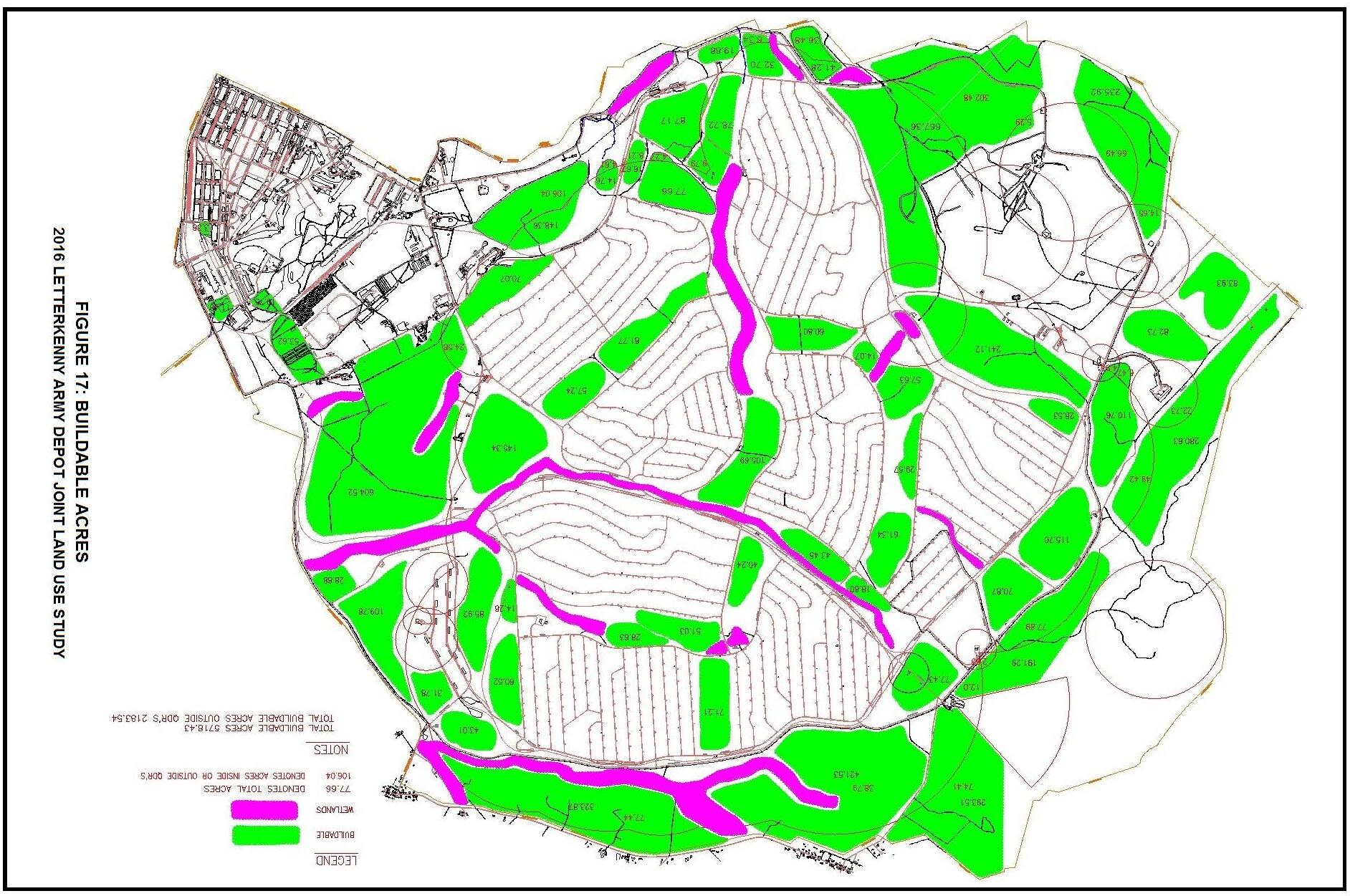
Land uses within the Depot itself consist of largely industrial areas in the southeast corner of the Depot and vast munitions storage areas and buildable acreage on the preponderance of the total base. The mapping on Figure 17 illustrates the buildable acreages and the open space areas consumed by munitions storage activities and wetlands.
Land Use Controls and State Regulatory Environment
The impacted municipalities surrounding the Letterkenny Army Depot control land uses in various ways. Greene Township and the Borough of Chambersburg maintain sophisticated and well established zoning ordinances, administered by professional zoning officers and predicated on well thought out comprehensive plans. Hamilton Township and Letterkenny Township, because of their less developed character and more rural culture, do not have zoning. These two Townships control development through the “subdivision and land development” process, and also have comprehensive plans in place. In as much as Greene Township and the Borough of Chambersburg control the usage of land and apply zoning control through certain performance standards, any impact of a future development in the township or borough on activities at LEAD is unlikely. In the cases of Letterkenny and Hamilton Townships, where large areas of agricultural land occur that have limited access to utilities such as sewer and water, the subdivision control mechanism is adequate for the purposes of controlling land development. It can be expected that all four municipalities will actively administrate the land use controls available to them. However, growth will occur, and it will increasingly locate in areas of potential interaction with activities at LEAD.
The State Regulatory environment enters into the picture of land use control via controls such as the permitting of environmentally sensitive uses such as quarries, sanitary landfills, or waste disposal facilities. Also, the state of Pennsylvania, through its Act 537 procedures, controls the growth of residential development in areas where no central sanitary sewer system exists. This process acts to force development around existing sanitary sewer lines and to slow the development of areas not served by the existing utilities. Additionally, the Pennsylvania
Department of Environmental Protection (PADEP) administers a permitting procedure for air emissions that offers a level of control over existing and potential manufacturing uses that may locate in the Cumberland Valley Business Park.
CHAPTER 5
Current and Projected Negative Externalities and
Land Use Conflicts
Related to Base Missions
Municipal Interviews
In addition to observation and review of all available documentation regarding any negative externalities caused in the context of Land Use Conflicts, the consultant conducted interviews of the leadership in each of the study area municipalities. The results of this interview process are contained in Figure 18. The thrust of the interviews was to discern any adverse impacts of activities at LEAD. As can be seen by reviewing the attached interview logs, the only adverse impacts that repeatedly emerged had to do with the occasional sound of munitions demolition.
• Greene Township has agreed to consider the study recommendations and their implementation in Greene Township to the extent that, in the sole judgment ofthe Supervisors of Greene Township, the recommendations are feasible and practical for implementation in Greene Township.
• LEAD is a valuable asset to the economic health of Franklin County. The CountyPlanning Commission has committed itself to assist in addressing anyexisting or potential conflicts in order to achieve compatibilityrecommendations resulting fromthe JLUS Plan.
• LIDA will continue to maintain a strong relationship with LEAD and will work toward successfully achieving compatibility recommendations resulting from the JLUS plan.
• CASD recognizes that LEAD is a valuable asset to the economic health of Franklin County would be willing to work towards achieving anydistrict-related compatibilityrecommendations resulting fromthe JLUS plan.
Municipality: Letterkenny Township
Date: 5/25/2016
Interview Setting: Letterkenny Township Office
Attendees: Charles Myers, Chairman of Board of Supervisors
• Letterkenny Township commits to a good faith effort to implement the recommendations made by the Joint Land Use Study Committee to the extent that the recommendations are feasible, practical, and as agreed to by the Board of Supervisors.
• The Borough of Chambersburg has agreed to consider the study recommendations and their implementation to the extent that the recommendations are feasible and practical in the opinion of the Borough.
Municipality: Hamilton Township
Date: 5/26/2016
Interview Setting: Hamilton Township Office
Attendees:
Michael K. Kessinger, Chairman of Board of Supervisors
Debra Hollenshead, Secretary of Board of Supervisors
Interviewers: Tim Cormany
Scott Shildt
Issues discussed:
1. Adverse impacts of activities at LEAD
• Occasional sound of munitions demolition. Constituent calls are usually from the Kensington Heights neighborhood and are primarily curiosity. Most complaint calls usually originate from the same residents
• Occasional dust plume associated with munitions demolition. No citizen complaints.
2. Commitment:
• Hamilton Township commits to a good faith effort to implement the recommendations made by the Joint Land Use Study Committee to the extent that the recommendations are feasible, practical, and as agreed to by the Board of Supervisors.
Noise Issues
As a result of the responses in the interviews, an investigation was conducted of the munitions demolition issue. The findings indicate that occasional complaints have been received from neighbors around LEAD as a result of the open detonation activities. Since weather conditions affect the potential for off-site noise as well as air emissions, LEMC closely monitors weather conditions to determine appropriate timing of OB/OD activities. LEMC follows an established set of weather condition restrictions that determine whether a detonation can occur. Conditions such as temperature inversion, precipitation, electrical thunderstorms, wind speed and direction, cloud cover, and cloud ceiling are determined in an effort to limit the potential for off-site noise and emissions. In addition to negative externalities raised in the interview process, three other potential concerns have been identified as a result of this planning exercise. The first of these is related to the protection and security of operations occurring at LEAD. The second has to do with radar testing missions that are occurring at the Depot. The third issue that raises concern from the community leadership is traffic. Traffic issues include the routing of truck traffic from LEAD and the Cumberland Valley Business Park to Interstate 81 at Scotland as well as the design of the five-way intersection at SR0997, SR0443, and Coffey Avenue. The review of these three issues reveals the following.
Force Protection
Due to the terrorist attacks against the United States on September 11, 2001, the country as a whole has become more vigilant, especially concerning those areas that present high-profile or
logistically critical targets. Force Protection is a top security priority of the Letterkenny Army Depot and the United States Army. The purpose of Force Protection is to prevent/deter aggressors, such as terrorists, from attacking vital military operations, and, if an attack occurs, minimizing the resulting damage. The location of sensitive missions within the Depot, their relation to surrounding outside land uses, and the accessibility to those missions need to be analyzed to determine the best methods of protection.
LEAD currently controls property that extends into the Cumberland Valley Business Park and also an additional 1.5 million square feet of space in the Park. This necessitates a sharing of public roadways and a co-mingling of non-military businesses and services with LEAD operations. As a result, LEAD and its surrounding communities maintain a mutually beneficial dialog on common issues and continue to develop and employ joint emergency preparedness plans.
Radar Testing
LEAD is currently testing Patriot and Hawk Radar Systems. Radar systems are reconditioned and tested prior to reuse. A 120m-safety zone has been established for the Patriot System and approximately a 400ft x 400ft area for the Hawk System, which rotates 360º. Testing zones of distance greater than required have already been established. LEAD is currently moving to a Configuration III System. The safety zone fence for this configuration has already been installed.
Concerns related to radar testing involve potential development in areas in the direction of “active” radar testing. The safety zone fenced area will remain in control of LEAD. However,
future construction in areas of the “active” test direction beyond the fence represents a potential non-safety interference concern. This concern could result from the height of buildings, or the type of machinery or operations that may be located in the test direction, particularly machinery or equipment, which might operate in the same frequency as radar. The location of such operations and facilities could have a negative impact on LEAD radar testing and operation of incoming industry equipment. “Passive” testing of the radar units is conducted in a more southwesterly direction and would present less likelihood of any conflicting future land uses.
In the course of the development of the Cumberland Valley Business Park, being the area most impacted by the LEAD Radar Test Missions, LIDA coordinates construction activities located in the “active” radar testing direction with LEAD. Such coordination will allow property developers to consider alternatives that will avoid future encroachment issues.
Traffic
A tertiary issue that has surfaced with regard to negative externality has to do with vehicular traffic attempting to connect between I-81 Exit 20 interchange and old gates numbered six and five, now entrances to LEAD and the Cumberland Valley Business Park. In an effort to protect the residential communities in the villages of Culbertson and Greenvillage, truck traffic has been directed to utilize SR0433 (Sunset Pike) and Route 11 (Molly Pitcher Highway). However, some truck traffic continues to use the restricted section of SR0997, creating negative impacts to the adjoining residential neighborhood. Solutions must be developed and implemented to further reduce these occurrences.
Greene Township collects traffic impact fees for subdivision and land development plans that occur in their municipality. The Township is divided into districts. Fees collected for each specific district are applied to projects in that district. Currently, Greene Township has funds set aside for the improvement of the Advantage Avenue-Coffee Avenue intersection. These improvements include additional turning lanes and upgraded signalization. Vehicular congestion at the intersection of SR0997, SR0433, and Coffey Avenue during shift changes is also a concern. Greene Township is aware of the need to improve this intersection, however the Township does not have sufficient funds to move the project forward. The Township is currently applying for multimodal funding from PennDOT to investigate improving this intersection with additional turning lanes and modified signalization. Additional funding and partnership with both LEAD and PennDOT may be required for these improvements to be fully realized. Franklin County now has a Metroplitan Planning Organization (MPO) for the purpose of evaluating regional transportation projects. Surrounding municipalities and the County should urge the MPO to prioritize the affected roads and to investigate ways to improve traffic conditions impacting the Letterkenny complex.
Educational Opportunities
Many LEAD and LEMC missions require a technically skilled workforce in vocations such as avionics, electronics, and munitions. The opportunity exists for Chambersburg Area School District, local universities, and LEAD to create programs aimed at developing homegrown, technically proficient workers. This would keep talented workers in Franklin County, raise average wage levels, and make LEAD a more attractive location for ongoing, technicallydemanding missions and affiliated work.
COMMUNICATION WITHIN THE COMMUNITY
In addition to the interaction afforded as part of the JLUS process between the County, local municipalities, the Army, and various other participating stakeholders, the completed research validates a need for ongoing, substantive, and enhanced community dialogue and relationships. From a perspective of regular communication, the entity known as Team Letterkenny has historically and locally played the role of facilitator. Team Letterkenny is a coalition of key community policy-makers under the direction of the Franklin County Area Development Corporation (FCADC). Its primary purpose is to avail itself of all applicable community, state and federal resources to support LEAD initiatives intended to strengthen the military value of the installation.
Team Letterkenny members include FCADC, Franklin County, Greene Township, Letterkenny Township, Hamilton Township, Chambersburg Borough, Chambersburg Area School District, Summit Health, the Greater Chambersburg Chamber of Commerce, LIDA, U.S. Senators Pat Toomey and Robert Casey, U.S. Congressman Bill Shuster, State Senator Richard Alloway, and State Representatives Rob Kauffman, and Paul Schemel. The Pennsylvania Military Communities Enhancement Commission also serves as an ex-officio member.
Although the Depot is Team Letterkenny’s reason for being, LEAD attends Team meetings but is not considered an official member. In the event of a BRAC action, a heightened threat assessment, or advanced military support activity, LEAD personnel may become increasingly restricted in the amount of information they can share. Consequently, official membership status is not a consideration to avoid any semblance of conflict.
Team Letterkenny meets quarterly with topics of discussion ranging from mission, expansion/contraction, and work force development to targets of opportunity and known operational challenges. The Team’s purpose is to create and sustain a forum for communication wherein issues, concerns and challenges identified in the JLUS, the Economic Impact Study, and beyond can be effectively managed and addressed to the benefit of all.
The Team Letterkenny approach is an excellent framework within which the community and LEAD can strengthen their bonds and their shared resolve to find solutions to emerging and potential conflicts. As partners in the Depot’s future, the affected shareholders must strive to evolve communication into a complete two-way discourse where not only internal LEAD and business park external impacts are assessed, but also where greater regional and municipal issues (land use, transportation, economic, political, demographic and infrastructure) are evaluated with respect to the Depot’s continued efficiency and prosperity. Regardless of the entity that ultimately serves as the conduit for these efforts, its role is undeniably critical to the goals of this JLUS and to the continued health of the entire community.
CHAPTER 6
Current and Projected Land Use
Encroachments
Current and Projected Land Use Encroachments
This review of land use conditions as they currently exist, and as are now projected, has revealed one potential outside encroachment on LEAD mission activities. Greene Township adopted Ordinance 2004-1 on February 24, 2004, which amends the Greene Township Zoning Ordinance Chapter 105, Article III, Section 105-15 entitled Chambersburg Municipal Airport Zoning District. This amendment created a number of Airport Zones and related Allowable Height Formulas. These zones establish maximum height limitations for man-made and naturally occurring objects in order to minimize potential problems for aircraft utilizing the Chambersburg Municipal Airport. Figure 21 shows the relevant portion of the Greene Township Zoning Map, which illustrates the various Airport Zones and the Allowable Height Formulas. The zones on this map are shown to extend beyond the borders of Greene Township, covering portions of the Letterkenny Army Depot, Letterkenny Township, Hamilton Township, Chambersburg Borough, and Guilford Township.
Aside from the airport issue, no other potential outside encroachments or impacts were identified. The development that has occurred and is likely to occur in the future is in the form of relatively low-density residential uses, which are slowly appearing within the established existing agricultural land use base. The mission activities at LEAD generate very little in the way of negative externalities, and the mission assignments that LEAD is currently pursuing, or is likely to pursue in the future, are such that they are well-contained within the boundaries of the Depot. As such, it is expected that there will be little to no encroachment occurring in the foreseeable future. Consequently, little or no impact on the Depot missions will occur as a result of the projected continued growth.
The single area where significant development will occur, other than the low-density residential conversion of portions of the surrounding agricultural land, is in the area of the Cumberland Valley Business Park. The plans to develop a business and manufacturing area have not produced any encroachments on the Depot’s missions. However, as development occurs in this area, two factors are important to the character of said development. First, the Greene Township Zoning Ordinance will control any development activities through performance standards. Specifically, the Greene Township Zoning Ordinance states “No land or building in any district in the Township shall be used or occupied in such a manner so as to create any dangerous or objectionable elements as to adversely effect the surrounding area or premises”. All uses of land or buildings shall initially and continuously comply with a detailed list of applicable performance standards contained in the Greene Township Zoning Ordinance, and established by Federal and State Agencies.
Secondly, in addition to this zoning control there exist independent use and performance controls established by LIDA. These standards for development of the Business Park are in place, professionally administered, and legally binding to all property holders. Based on the existence of these controls and the Greene Township Zoning Ordinance, any development, existing or projected in the LIDA Cumberland Valley Business Park, is unlikely to encroach or impact negatively on any Depot mission.
CHAPTER 7
Recommendations for Consideration
Recommendations
Through research into what other military jurisdictions have implemented, what local governments in conjunction with LIDA and LEAD are currently accomplishing in this location, and in the context of constructive suggestions from the leadership in the community as well as the advice of the Policy and Technical Committees, several recommendations have been developed. The usefulness and ultimate success of this plan and the inter-relationships that occur between subject communities and the Letterkenny Army Depot will depend on whether the recommendations become a reality. The following are the recommended practices and policies resulting from this analysis that the relevant parties should consider initiating and implementing:
1) Enhance community relations to ensure that citizens of the affected areas are kept informed through direct contact about the changes that may result from revisions or additions to mission plans at LEAD and changes in the municipalities (including LIDA) which may affect LEAD.
2) Develop and coordinate education programs between LEAD, LEMC, CASD, local universities, and the local communities in order to provide occupational and vocational opportunities that will serve to develop and maintain a homegrown, skilled labor force capable of attracting and sustaining new technically demanding missions to LEAD.
3) Maintain a clearinghouse of data collected during the course of preparing this JLUS and beyond that can be made available to LEAD, the study area municipalities, and the public. These records may be maintained in the offices of the JLUS sponsor, FCADC, and/or the JLUS consultant, Martin and Martin, Incorporated.
4) The surrounding municipalities should consider requiring disclaimer notations on subdivision and land development plans for property in proximity to the Depot advising
buyers of the potential negative externalities generated by mission activities at LEAD. By requiring such a note on plans the notification becomes accessible through the title search process and interested buyers are advised of the potential impact.
5) Monitor growth and change in the impacted municipalities in an effort to achieve early detection of potential encroachments on LEAD missions.
6) Maintain and improve regular communication among the leadership of the study area municipalities, LIDA, and LEAD. Local governments (including LIDA) should be encouraged to notify LEAD of specific proposals that may affect base missions. Such notification would allow LEAD to submit comments for consideration by local officials. LEAD should also be encouraged to notify local governments (including LIDA) concerning new missions that could impact, or be impacted by, adjacent land or land uses in order to address any potential issues. This will allow parties to provide comment at the concept stages and work together to develop best-fit solutions that are mutually agreeable.
7) In an effort to promote safety, efficiency and improved quality of life, it is recommended that LIDA, LEAD, the Franklin County MPO, and Greene Township work together closely to investigate possible improvements to the existing five-way intersection (SR0997, SR0433, and Coffey Avenue), and traffic routing between LEAD and Cumberland Valley Business Park, U.S. Route 11, and the I-81 Exit 20 Interchange at Scotland. In consideration of the study area’s regional economic significance, ongoing review of the Business Park and military traffic situation is an issue that should remain a regional priority for the life of these operations.
8) The majority of the above-referenced recommendations rely on a common thread to ensure successful implementation: improved communication between the community and LEAD. The affected parties should initiate leadership to establish a body that can meet regularly, and as otherwise needed, to discuss local, regional, and base developments and to work together to actualize the JLUS recommendations.
As is stated in the Joint Land Use Study Program outline as published by the Office of Economic Adjustment, Department of Defense:
“An important venue of a successful JLUS is building community consensus. If the JLUS has positive results the participating jurisdictions and military installation must agree to make good faith pledge to implement controls to achieve compatibility…. Experience from these studies has shown a high success rate and a generous effort can benefit both the jurisdiction and the installation by:
• Protecting the health and safety of residents living and working in the military installation.
• Preserving long-term land use compatibility between installation and the surrounding community.
• Promoting comprehensive community planning.
• Encouraging a cooperative spirit between local base command and local community officials.
• Integrating local jurisdiction’s comprehensive plans with the installation’s plans.”