EVA MALIS
LANDSCAPE ARCHITECTURE
USC MLA+U CLASS OF 2024


LANDSCAPE ARCHITECTURE
USC MLA+U CLASS OF 2024
Los Angeles, CA, 90026 | emalis@usc.edu | (661)476-6564
I am a community organizer and horticulturalist passionate about advocating for justice through design. I am deeply invested in the study of public space within urban environments, especially at the intersection of the housing crisis, park accessibility, and ecological resilience. I have a background in CA native plant horticulture, ecological restoration, environmental justice, and community organizing.
University of Southern California, Class of 2024 Masters of Landscape Architecture + Urbanism
University of California, Berkeley, Class of 2017 Environmental Sciences, B.S.
English Mandarin Chinese
CRAFT LA, Landscape Architecture Intern
• Assist with CAD construction documentation, planting design, and renderings for residential projects, with a focus on CA native plants.
LA River Fellows, Program Co-Coordinator
• In collaboration with Friends of the LA River, designed a curriculum for local high school students to engage with the urban ecologies of the LA River
RELM, Landscape Architecture Intern
• Conceptual design of a neighborhood park project in a low income community of color. Assisted with plant selection and construction documents for other ongoing projects in the office.
LA Parks Foundation, Nursery Manager & Design Consultant
• Managed local seed collection, propagation, and plant maintenance for a native plant nursery in Griffith Park.
• Co-designed and installed a fire-wise native plant demonstration garden for the LA Parks Foundation with Professor Esther Margulies.
Plant Material, Shift Manager
• Care for native plants in nursery, including watering, weeding, and pruning.
• Advise customers on plant selection, plant care, and garden design.
Amigos de los Rios, Project Manager
• Supported the implementation of thirteen green infrastructure projects within Low-Income Communities and Disadvantaged Communities in Los Angeles County.
CCED, Community Organizer
• Chinatown Community for Equitable Development (CCED) is a volunteerrun community group that advocates for a just and equitable Chinatown. The Fighting Developments Committee tracks gentrification and organizes campaigns to prevent unwanted development.
Theodore Payne Foundation, Nursery Sales Associate
• Cared for thousands of California native plants for sale in the nursery. Consulted customers on plant care, plant selection, and the benefits of native gardening.
Grand Canyon Trust, Uplift Coordinator
• Built a youth-led movement for climate justice in the Southwest, prioritizing indigenous youth.
• Coordinated a team of youth organizers to launch an annual youth-led conference that has become a hub of climate action.
• Traveled to the UNFCCC COP23 international climate negotiations in Bonn, Germany in November 2017 with a delegation of 14 young leaders. Led a series of strategic and impactful direct actions for climate justice.
Wetland Restoration in the SF Bay
Save the Bay and Merenlender Lab
Jan 2016 – May 2017
Spatial Patterns of Urban Riparian Corridors in Shanghai Society of Urban Ecology (SURE)
Jun – Jul 2016
Phytoremediation of Arsenic Contaminated Soils
Pallud Lab
Aug – Dec 2015
Community Urban Soils Project Richmond, CA
Sep – Dec 2014
CLASS Fund Honors Scholarship
USC MLA+U, 2023
Student Excellence Award
USC MLA+U, 2022
1st Place Team Project: Bringing Climate Justice to Skid Row Pando Days 2021
UNFCCC COP23 U.S. Youth Delegate SustainUS, 2017
Emerging Leaders Program in the Outdoors and Conservation SHIFT, 2017
Undergraduate Scholarship
Udall Foundation, 2016
Doris Duke Conservation Scholars Program Fellowship
Northern Arizona University, 2016
Spring Grant Award
The Green Initiative Fund
UC Berkeley, 2015
Adobe Suite
Rhino
AutoCAD
Land F/X
ArcGIS
Grasshopper
Twinmotion
Enscape
CA Native Plant Identification
Planting Design & Consulting
Horticultural Propagation
Landscape Maintenance
Community Outreach
Facilitation & Training


CARCERAL LANDSCAPES
DESIGNING FOR THE MARGINS
REGIONAL SOIL FUTURES
INDIGENOUS WATERSCAPES
ASSORTED RESEARCH
INTERNSHIP WORK
MATERIAL STUDIES
My ongoing thesis research focuses on carceral landscapes in the Tulare Basin. I am studying and cataloguing their socio-spatial conditions, the landscape-based systems they participate in, and their potential for liberatory futures. I aim to answer these two questions: 1) How do prisons shape the landscape of the Tulare Basin, and vice versa? And 2), how can we design liberatory futures in a landscape of mass incarceration?
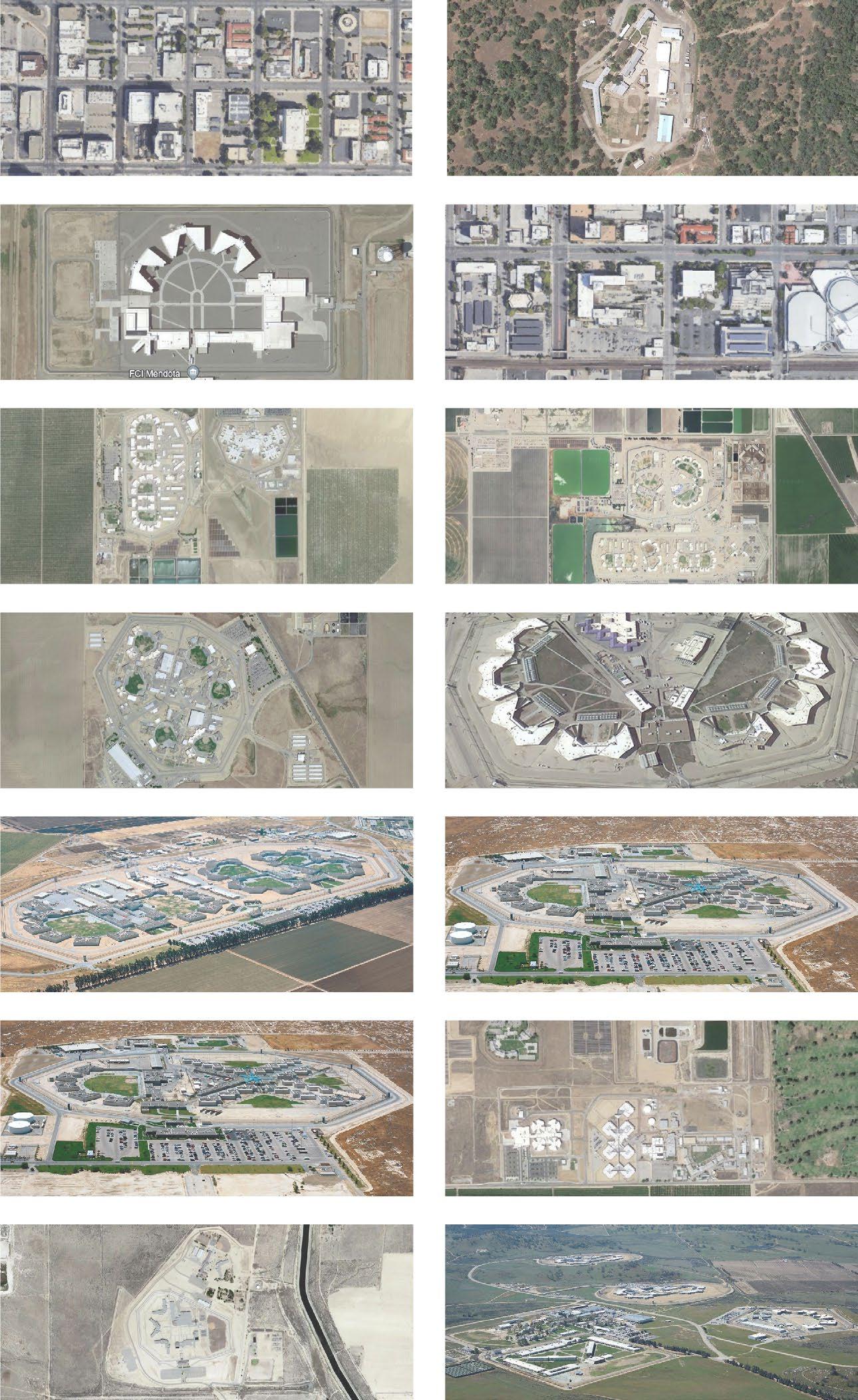

My research begins with the existing conditions of the prison industrial complex in the Tulare Basin and their impact on prisoners cycling through the carceral system. I aim to explore the unique implications of siting prisons in California’s central valley landscape on a socioeconomic, racial, and spatial level. My research will span the arenas of labor, migration, criminal justice, rural economies, punitive architecture, climate resilience, and abolitionist futures. I will also collect extensive existing precedents for the removal of prisons, the repurposing of former prison sites for future public good, and exploratory innovations in restorative and transformative justice.
This board catalogues 17 carceral sites in the Tulare Basin: prisons, jails, detention centers, and labor camps. It tracks the different types of prison labor being performed at each site, as well as the environmental hazards that inmates face. The following pages catalogue the spatial typologies of carceral infrastructure, examine the landscape implications of prison labor, and explore a framework to imagine possible futures for the carceral system.


Both human and non-human life are in crisis in our cities. The most vulnerable humans and wildlife are both forced to live on the margins of our society. Sepulveda Basin Recreation Area is a vital green space in the middle of the San Fernando Valley, home to 300+ unhoused individuals and hundreds of species of wildlife. Designing for the Margins transforms Sepulveda Basin into a welcoming shelter for both human and non-human life on the margins of our society.


This project begs the question: how do we design for both the housing crisis and ecological crisis in our cities? How do we create public green spaces that are not hostile to our unhoused populations and displaced wildlife? This urban design framework expands shelter and habitat for the Basin's inhabitants, improves connectivity between key resources, and enhances accessibility. The marginal typologies below outline strategies that were implemented at a local scale on a corner of the Sepulveda Basin, but could be implemented across the Basin and similar public green spaces in Los Angeles County.
Zooming in to the Southwest edge of the Basin, the existing golf course is restored to native habitat with braided walking trails for recreational use. A wildlife bridge extends over the US 101 and Burbank Blvd and meets a series of connectivity corridors that lead to the Santa Monica Mountains. Across Encino Creek from the wildlife bridge is a raised safe encampment zone that will allow the unhoused community to safely camp within the Basin without being evicted by the Flood Control District. The proximity of the existing community garden presents a key opportunity to pair this intervention with supportive programming for the unhoused, including a food bank, resource center, tiny home village and RV park. With effective and intentional outreach, this project can radically reshape the housed and unhoused community’s relationship with each other and with their local ecologies.
connectivity corridor


primary trail
secondary trail
safe encampment zone habitat patch


pedestrian trail
bikeway
residential zone habitat patch
shelter connectivity access


Urban soils of the LA Basin often are threatened by contamination, sealing, compaction, erosion, and climate change. This project explores possible futures based on reciprocal relationships between LA urban soils and LA communities. What can our communities offer to the soil, and what can the soil offer our communities?

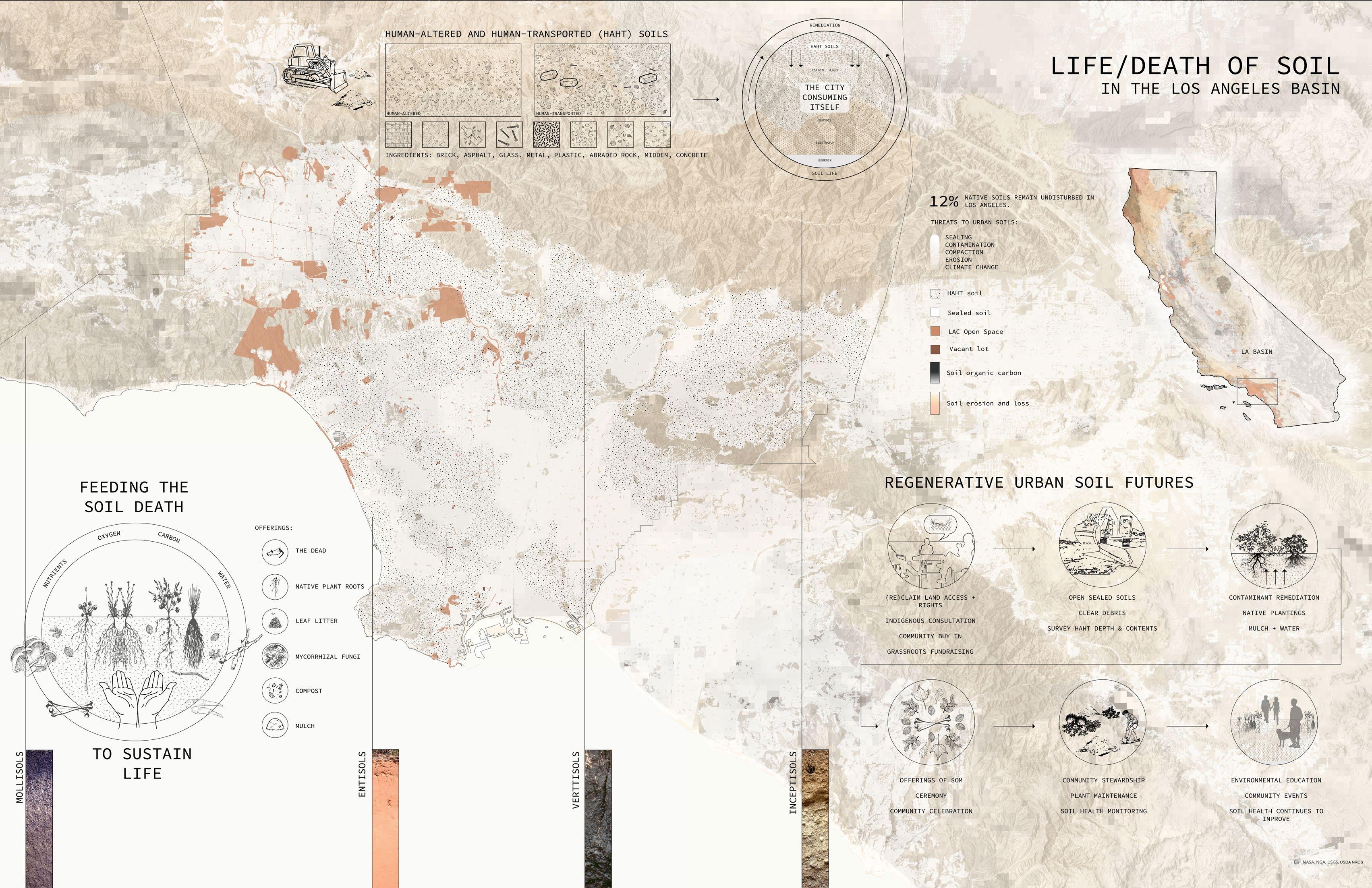


The pathway to soil life in East Los Angeles extends along a corridor of an existing railroad with multiple vacant lots alongside its reaches. This “brown corridor” provides an opportunity for neighborhood connectivity while also rebuilding the relationship between a community and its soils. The corridor follows a sequence of soil interventions, from reintroducing oxygen to a sealed asphalt lot, to rebuilding the carbon in industrial fill soil, to remediating heavy metals in contaminated soils, to restoring the relationship of water in floodplain soils.

Eastside Soil Park transforms a vacant lot of urban HAHT dirt into a thriving community-led soil stewardship project. This project explores the importance of soil to supporting all life and opens a dialogue about the health of urban soils. What would community stewardship of our soil health look like, and how can we establish reciprocal relationships with our neighborhood soils? In industrial East Los Angeles, the soils are depleted of carbon and struggle to support life. However, with community input of organic matter, Eastside Soil Park can restore an ecology of microbial soil life and become a great carbon sink for the city. It can directly involve the community in Los Angeles' Healthy Soils Program and "Brown New Deal" commitments to tend to urban soil health and sequester carbon through soil restoration. mmunities offer to the soil, and what can the soil offer our communities?
The park features hugelkultur mounds planted with native plantings, heaps of community compost, community garden plots, an educational soil profile wall, walking trails, shade trees, and soil-themed play elements. Over time, these interventions reintroduce carbon and moisture to rebuild the humus layer and reintroduce an ecology of microbial life that can better support the macro. As the hugelkultur mounds compress and sink over time, the community continually adds compost and builds up the mounds, a process of "feeding the soil". This marks the beginning of a long-term, mutually reciprocal relationship between the Eastside community and its soils. The native plants and community garden plots will grow and flourish, while the soil life flourishes underneath.
COMMUNITY COMPOST SOIL-THEMED PLAY SOIL PROFILE WALL HUGELKULTUR MOUND COMMUNITY GARDEN BEDSThe Owens Valley is inevitably tied to Los Angeles' dramatic water history. However, the stories told about California's water often leave out the elaborate water management systems of California's indigenous peoples. This site design for the Eastern Sierra Visitor Center retells the story of water through the lens of the Bishop Pauite and Shoshone peoples.

The Owens Valley is famous for its dramatic ties to Los Angeles' water violent history. However, it was once known as Payahuunadü, the land of flowing water. East of the Sierra Nevadas, snowmelt used to flow directly into the Owens River and the Owens Lake, and the Paiute and Shoshone people used to heavily manage these water systems to support life throughout the valley. They created grids of irrigation channels to support a lush green valley of abundance. Today, this water is directed hundreds of miles south through the LA aqueduct for urban use. The landscape left behind is alien, dusty, and deserted.
The Eastern Sierra Gateway Visitor Center is a major stop for a people passing through the valley. From hikers getting permits to roadtrippers taking a bathroom break, this center is the key access point for storytelling about this place. However, the story of water that is told here centers around Los Angeles, Mulholland, and the LA aqueduct. This project creates an immersive landscape experience that tells a more holistic story of water in the valley, centering indigenous histories of water management and honoring the slow movement of water across the land.

 INDIGENOUS IRRIGATION
RIPARIAN CHANNELS
PETROGLYPH LAND ART MONUMENT
EPHEMERAL POND AND VIEWPOINT
INDIGENOUS IRRIGATION
RIPARIAN CHANNELS
PETROGLYPH LAND ART MONUMENT
EPHEMERAL POND AND VIEWPOINT
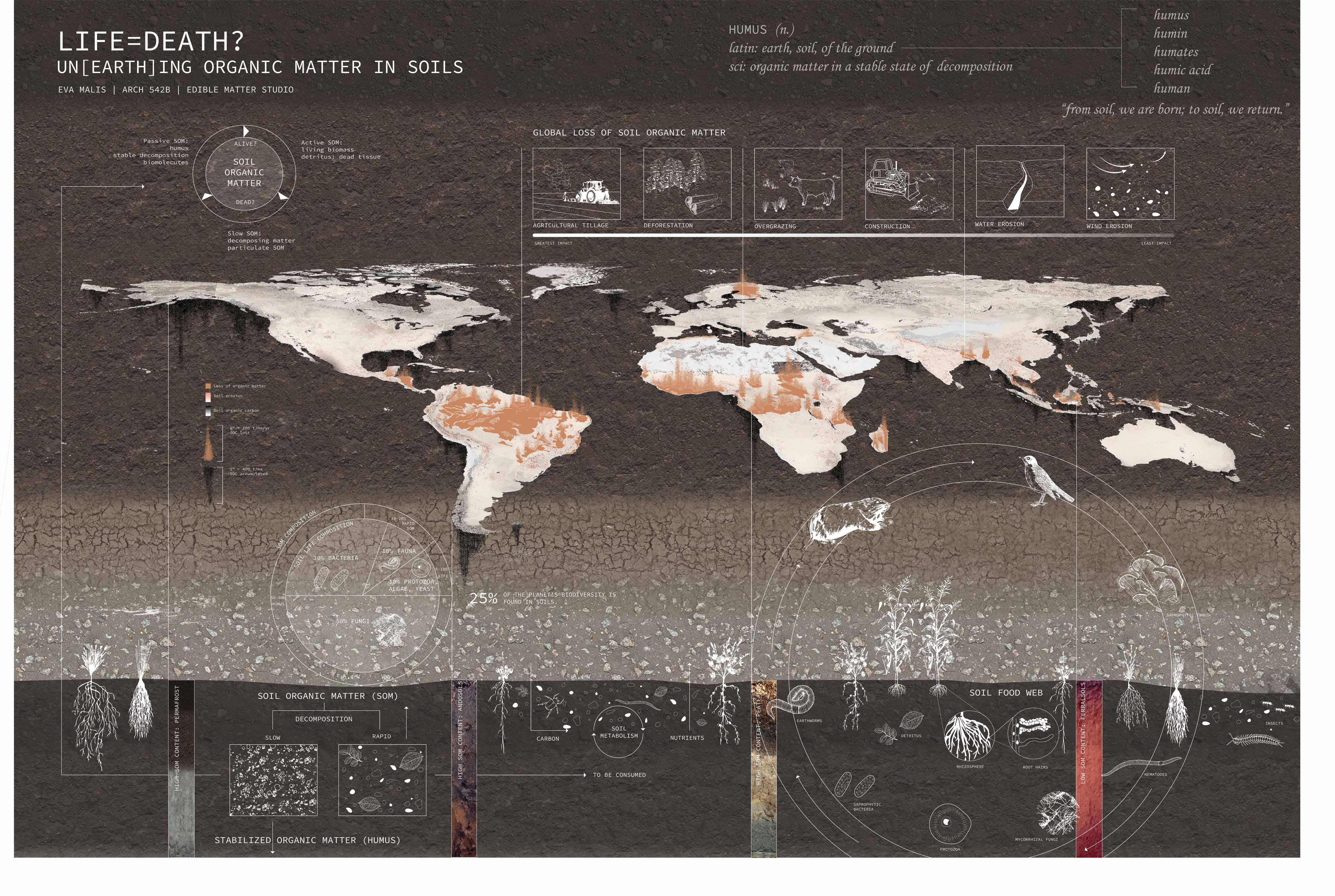
Research projects for various classwork. Here I take a deep dive into global soil conditions, resource extraction in the Central Valley, and regenerative planting design on the USC campus.
05.01 Life and Death of Global Soils
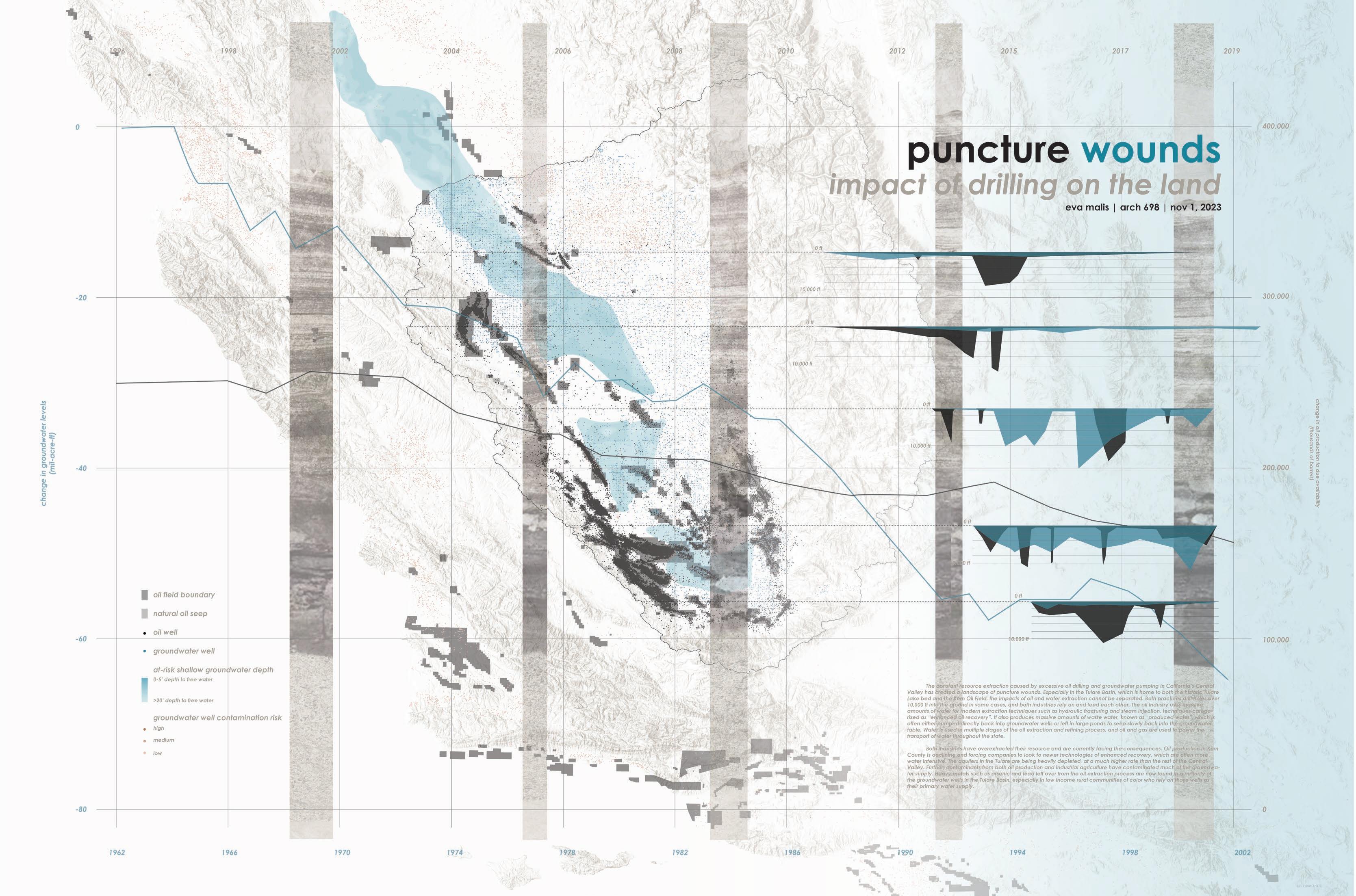
05.02 Oil and Water Extraction in Central CA
05.03 Coastal Scrub Campus: Planting Native @ USC


Explorations of planting design with California native plants on the USC campus taking into account microclimate and the historical ecologies of the coastal sage scrub plant community. Plants were selected based on habitat quality, aesthetic value, shade tolerance, low water requirements, and bloom periods.


Cercis occidentalis
Garrya elliptica
Platanus racemosa
Gambelia speciosa
Muhlenbergia rigens
Polystichum munitum
Rhus integrifolia
Ribes viburnifolium
Clinopodium douglasii
Heteromeles arbutifolia
Solidago californica
Frangula californica
Carex pansa
Monardella villosa
Holodiscus discolor
Iva hayesiana
Juncus patens
Lepechinia fragrans
Achillea millefolium
Bouteloua gracilis
Phyla nodiflora
Cornus sericea


Diplacus longiflorus
Heuchera maxiima
Keckiella cordifolia
Encelia californica
Baccharis salicifolia
Sisyrinchium bellum


Participated in an independent study where I worked as a part of a team of six students to design and implement two test plots on the USC campus. Test Plot is a community stewardship project that focuses on regenerative planting practices with sites across Los Angeles. I helped to develop the planting design concept and focused on the question of community engagement and labor acknowledgement. This test plot is an experimental study of the efficacy of vertical mulching on native plant growth and soil health.
shady swale permeableMy summer internship focused on the conceptual design of a pro bono project to redevelop a neighborhood park in the Eastside neighborhood of San Antonio, Texas. This project partnered with a community organization to bring forth a vision of a multi-generational nature-play green haven for an underserved community of color. I helped with the site analysis, conceptual design drawings, and created a 3D model, renderings, and presentation materials for the project under the guidance of Yong Kim and Luning Li. I also assisted on various projects in my internship, creating plant palettes and


Previous Page: (Left) A series of point, line, and polygon logics were extracted from an image and projected onto three physical models made of carved soap, zip ties, and yarn, respectively. Then, these physical models were digitized in Rhino and fabricated through CNC milling, a topographic laser cut, and a laser cut rib model. (Right) Topographic form model on CNC-milled foam was later plaster-cast and then slumped glass on top to produce the glass model.
Current Page: (Left) 3D digitized models of the experimental physical models on the previous page. (Center) A plaster cast on boulder was used to form the base of a landscape model. The plaster was then carved to reveal an oak woodland landscape of walking trails and viewing decks. Then, the physical model was digitized and recreated in Rhino. (Below) Sketch model of a hillside outdoor classroom on Catalina island.


