Water - June 2012
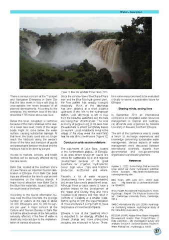
Figure 12: Blue Nile waterfalls (Picture: Maes, 2011)
There is serious concern at the Transport and Navigation Enterprise in Bahir Dar that the lake levels in future will drop to unacceptable low levels because of all planned developments. According to the enterprise, the minimum level of the lake should be 1785 meter above sea level. Below this level, navigation is restricted because of the many shallows in the lake. At a lower lake level, many of the larger boats might hit rocks below the water surface, causing substantial damage. At that level, the boats could also no longer reach the harbours along the western shore of the lake and transport of goods and passengers between the boat and the harbours had to be done by barges. Access to markets, schools, and health facilities will be seriously affected during low lake levels. Bahir Dar, located at the southern shore of Lake Tana is an important tourism destination in Ethiopia. From Bahr Dar, boat trips are offered on the lake to visit ancient monasteries on the various islands. A major tourist attraction near Bahir Dar is the Blue Nile waterfalls, located about 35 km south-west of the town. According to the tourist information bureau near the Blue Nile falls, the average number of visitors at the falls is about 30 000 Ethiopians and 10 000 foreigners per year. A major concern at the Culture and Tourism Bureau in Bahr Dar is that the attractiveness of the falls will be seriously affected, if the flow of water is drastically reduced due to the implementation of various structures.
Since the construction of the Chara-Chara weir and the Blue Nile hydropower plant, the flow pattern has already changed drastically. Much of the discharge has been diverted at a short distance upstream of the falls to the hydropower station. Less discharge is left to flow from the beautiful waterfalls and the falls are losing their attractiveness. The local economy of people living in the area near the waterfalls is almost completely based on tourism. Local inhabitants living in the village of Tis Abay (near the waterfalls) fear the loss of income in future.(Figure 12) Conclusion and recommendations The catchment of Lake Tana, located in the northwestern plateau of Ethiopia, is an area where resources issues are critical for sustainable local and regional development because of its great potentials for irrigation; hydroelectric power; high value crops and livestock production, ecotourism and others. Recently a lot of water resource developments have been implemented and in near future more projects will arise. Although these projects seem to have a positive impact on the development of the region and country, they also have negative local impacts and may result in conflicts or instability at a smaller scale. Before going on with the implementation of more structures it is important to focus on possible environmental impacts. Ethiopia is one of the countries which is expected to be strongly affected by climate change and more pronounced droughts are expected in future. There-
fore water resources need to be evaluated critically to secret a sustainable future for Ethiopia. Sharing minds, saving lives In September 2011 an international conference on integrated water resources management in tropical and subtropical drylands was organized by Mekelle University in Mekelle, Northern Ethiopia. The aim of the conference was to create a forum to exchange experiences and knowledge concerning sustainable water management. Various aspects of water management were discussed between international scientists, experts from governmental and non-governmental organizations and leading farmers. References Ayalew, L., 2002. Some things that we need to know about our rivers’ hydropower potential. Online available: http://www.mediaethiopia. com/engineering.htm. BBC News, 28th June 2011, online available: http://www.bbc.co.uk/news/world-africa-13944550. IPCC Fourth Assessment Report (2007). Working Group I Report “The Physical Science Basis”, Cambridge University Press, Cambridge, 996 p. SMEC International Pty Ltd, (2008). Hydrological monitoring network. Hydrological study of the Tana-Beles sub-basins, 47p. BCEOM, (1997). Abbay River Basin Integrated Development Master Plan Project.Phase 2: Data collection – site investigation survey and analysis, Section II: Sectoral Studies, Volume II: Water Resources – Hydrology, p. 64-83.
27