Photo by Olena Bohovyk on Unsplash.
Effective tools to monitor biodiversity Protecting biodiversity is widely recognised as an urgent priority, yet at the same time, decision-makers are under pressure to modernise infrastructure. We spoke to the team behind the GUARDEN project about their work in developing tools to monitor biodiversity and keep it at the forefront of decision-makers’ minds when considering development plans. The
world’s biodiversity is in decline, with animal and plant species disappearing across the globe at a rapid rate, prompting intense efforts to protect the natural world and restore habitats. Effective monitoring tools have an important role to play in these terms, both in assessing the current biodiversity status of specific areas and in evaluating the impact of restoration work, an issue at the core of the EU-backed GUARDEN project. “We aim to both build and improve tools to monitor biodiversity. Secondly, we’re also working to evaluate and assess ecosystemic services. Finally, we’re developing tools to inform decision-makers when they make decisions around protecting biodiversity,” says Jean-Marc Sadaillan, a Project Officer at CIRAD, an agricultural research organisation in France, responsible for coordinating the project.
34
Photo by Alexander Wark Feeney on Unsplash.
proposed path of the railway, and identify which plants are currently there. This provides decision-makers with a clearer picture in terms of the current biodiversity status, so they can properly assess the ecosystemic services currently in the area, which can then inform protection efforts. The four case studies are being conducted primarily in countries around the Mediterranean, with broadly similar climates and biodiversity profiles, yet they differ in certain aspects. Some of them are in urban areas (such as the Barcelona metropolitan area or industrial sites in Cyprus) and others are more rural, while part of one case study is based in Madagascar, in collaboration with
“We aim to both build and improve tools to monitor biodiversity. We’re also working to evaluate and assess ecosystemic services, and are developing tools to inform decision-makers when they make decisions around protecting biodiversity.” Case studies
GUARDEN technologies The project brought together 18 different organisations across Europe and Madagascar to work on variety of technologies designed to provide a deeper and more accessible picture of biodiversity. One example is Pl@ntNet, an AI-driven tool available for several years on smartphones and the web, which enables users to identify plant species instantly. This technology has been significantly improved over the course of the project and made more accessible. In particular it now better serves the needs of decision-makers, with the inclusion of features such as plant community identification, allowing users to identify plants using high resolution quadrat photos. As part of its ambition to provide powerful tools to both citizens and decision makers, GUARDEN developed new solutions such as GeoPl@ntNet — an innovative mapping tool that uses state-of-the-art AI models to generate interactive maps predicting the habitat types and plant species likely to occur across European landscapes. Two major databases, the Global Biodiversity Information Facility (GBIF) and the European Vegetation Survey, have been used by the project team in developing the GeoPl@ntNet tool.
Each dashboard is co-designed by the different stakeholders, so alternative perspectives are taken into account, helping to meet the specific needs of individual projects. In developing these different tools, the project team have considered biodiversity in quite a broad sense. The AvesEcho technology for example includes data on almost 600 different bird species, while Pl@ ntNet covers around 70,000 plant species, representing almost a fifth of the estimated 350,000 plant species identified around the globe.. The project team is developing or improving a constellation of technologies which contribute to the same goal of facilitating the protection of biodiversity.
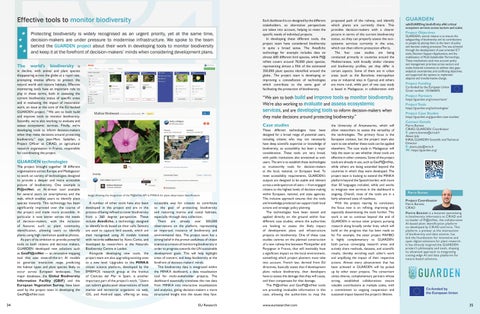
Image showing the integration of the Pl@ntNet API in MINKA for plant observation identification.
A number of other tools have also been developed in the project and are in the process of being refined to cover biodiversity from a 360 degree perspective. These include AvesEcho, a technology designed to identify birds based on their calls. Sensors are used to capture bird sounds, which are then recognised using AI models trained with records collected by Xeno-Canto, and developed by researchers at the Naturalis Biodiversity Centre in Leiden. Alongside developing new tools, the project team are also upgrading existing ones to a new level. Upgrades to the MINKA citizen science platform, developed by the EMBIMOS research group at the Institut of Ciències del Mar in Spain, is another important part of the project’s work. “Users can submit geolocated observations of both marine and terrestrial organisms via web, iOS, and Android apps, offering an easy,
accessible way for citizens to contribute to the goal of protecting biodiversity and restoring marine and costal habitats, especially through data collection. There are already over 500,000 observations on the platform, representing an important resource of biodiversity and environmental data. The project team has a strong belief in the proven usefulness of citizen science as a means of monitoring biodiversity in order to progress towards the UN sustainable development goals. This will help highlight areas of concern, and keep biodiversity at the forefront of decision-makers’ minds. This biodiversity data is integrated within the MINKA dashboard, a data visualization tool for multi-stakeholder projects. The dashboard essentially translates the raw data from MINKA into interactive visualizations and analytics, giving decision-makers a more structured insight into the issues they face.
EU Research
These different technologies have been designed for a broad range of potential users, including citizens who may not necessarily have deep scientific expertise or knowledge of biodiversity, so accessibility has been a major consideration. These tools are very broad, with public institutions also envisioned as endusers. The aim is to establish these technologies as trustworthy tools for decision-makers at the local, national, or European level. To meet accessibility requirements, GUARDEN’s outputs are designed to be usable and relevant across a wide spectrum of users — from engaged citizens to the highest levels of decision-making within European, national, and state agencies. This inclusive approach ensures that the tools and knowledge produced can support both local actions and strategic policy planning. The technologies have been tested and applied directly on the ground within four different case studies, where the authorities are looking to assess the likely impact of development plans and infrastructure projects on biodiversity. One of these case studies centres on the planned construction of a new railway line between Montpellier and Perpignan in France, that will inevitably have a significant impact on the local environment, something which project planners must take into account. French law, derived from EU directives, basically states that if development plans reduce biodiversity, then developers have to assess the damage that they will cause, and then compensate for that damage. The Pl@ntNet and GeoPl@ntNet tools are providing invaluable information in this case, allowing the authorities to map the
www.euresearcher.com
the University of Antananarivo, which will allow researchers to assess the versatility of the technologies. The primary focus is the European context, but the project team also want to see whether these tools can be applied elsewhere. The case study in Madagascar will help the team to see whether those tools are effective in other contexts. Some of the project tools are already in use, such as GeoPl@ntNet, while others are being extended beyond the countries in which they were developed. The project team is looking to extend the MINKA platform beyond the Spanish border, with more than 50 languages included, while and works to integrate new services in the dashboard is ongoing. Overall, most of the tools are in a fairly advanced state of readiness. With the project nearing its conclusion, the focus now is on refining, improving and especially disseminating the tools further. This work is set to continue beyond the end of GUARDEN in various sister projects pursuing research along broadly similar lines, which will build on the progress that has been made so far. For example, the sister project MAMBO is highly complementary to GUARDEN: both pursue converging research areas and actively share methods, datasets, and scientific results, thereby enriching each other’s work and amplifying the impact of their respective actions. Almost every advancement that has been achieved in GUARDEN will be picked up by other sister projects. The consortium unites diverse, complementary partners whose strong, established collaborations ensure valuable contributions at multiple scales, with a commitment to ongoing cooperation and sustained impact beyond the project’s lifetime.
GUARDEN
safeGUARDing biodivErsity aNd critical ecosystem services across sectors and scales
Project Objectives
GUARDEN’s central mission is to ensure the safeguarding of biodiversity and its contributions to people by placing them at the heart of policy and decision-making processes. This was achieved through the development of user-oriented ICT tools, Decision Support Applications, and the mobilisation of Multi-Stakeholder Partnerships. These mechanisms took into account policy and management priorities across sectors and scales, fostered consensus to address data gaps, analytical uncertainties, and conflicting objectives, and supported the options to implement adaptive and transformative change.
Project Funding
Co-funded by the European Union Grant number 101060693.
Project Partners
https://guarden.org/consortium/
Project Tools
https://guarden.org/technologies/
Project Case Studies
https://guarden.org/guarden-case-studies/
Contact Details
Pierre Bonnet CIRAD, GUARDEN Coordinator E: pierre.bonnet@cirad.fr Alexis Joly INRIA, GUARDEN Scientific and Technical Director E: alexis.joly@inria.fr W: https://guarden.org/
Pierre Bonnet Project Coordinator Pierre Bonnet, CIRAD Pierre Bonnet is a botanist specialising in biodiversity informatics at CIRAD and co-leader of Pl@ntNet, the collaborative AI-based plant identification platform co-developed by CIRAD and Inria. This platform, a pioneer at the intersection of biodiversity and data science, has laid the foundations for innovative and open digital solutions for plant research. It has directly inspired the GUARDEN project’s philosophy and tools, shaping its advanced approach to integrating cutting-edge AI and data platforms for nature-based solutions.
35