International Journal of Scientific and Research Publications, Volume 8, Issue 10, October 2018 ISSN 2250-3153
235
Computations of Geoid Undulation from Comparison of GNSS/Levelling with EGM 2008 for Geodetic Applications Oluyori, P. D., Ono, M. N. and Eteje, S. O. Department of Surveying and Geoinformatics Nnamdi Azikiwe University, Awka, Anambra State, Nigeria. DOI: 10.29322/IJSRP.8.10.2018.p8230 http://dx.doi.org/10.29322/IJSRP.8.10.2018.p8230
ABSTRACT Consistency is an important characteristic in height systems which the mean sea level (msl) surface cannot guarantee. Only a geoid surface can provide height consistency. The quality of geoid undulation (N) will obviously affect the resulting orthometric height (H) determined from GNSS. The geoid undulation may be global, regional/national and local. Online software CSRS-PPP was used for post processing rinex data. đ?‘ đ??¸đ??şđ?‘€2008 was computed from AllTrans EGM2008 geoid calculator while h was used to compute đ?‘ đ??şđ?‘ƒđ?‘† from the relationship N= h-H. H is the existing orthometric height. Twenty-four controls with FCT 260 P as base reference station were used for this study. The computed standard deviation of differences inđ?‘ đ??şđ?‘ƒđ?‘† − đ?‘ đ??¸đ??şđ?‘€2008 (Ďƒ) is used as accuracy indicator and Ďƒ =0.419m .The root mean square error (RMSE) is 0.934m. This indicates the quality and reliability of the geoid undulation from the EGM2008 model. Comparing the observed đ?‘ đ??şđ?‘ đ?‘†đ?‘† and đ?‘ đ??¸đ??şđ?‘€2008 , the use of global models may not satisfy the accuracy level of orthometric height desired for local applications in the FCT, Abuja. GNSS (GPS) may be used along with local geoid model as a way to acquire acceptable orthometric height. The smaller the đ?‘ đ??şđ?‘ƒđ?‘† -đ?‘ đ??¸đ??şđ?‘€2008 makes it better model. The range of 1.585m from (đ?‘ đ??şđ?‘ƒđ?‘† -đ?‘ đ??¸đ??şđ?‘€2008 ) in this study is a strong indication that global models should be avoided as much as possible in local applications. Keywords: Geoid undulation, Ellipsoidal height, Orthometric height, EGM2008, Accuracy INTRODUCTION Geospatial data are acquired by space or conventional techniques. The space techniques of GNSS produce ellipsoidal heights (h) based on mathematical best-fit ellipsoid model of the earth surface. GNSS is presently used for coordinate (N, E, H) determination of points of interest on the earth. The orthometric height (H) is determined from the relationship given by Abdulkahdum (2015) and Eteje et al (2018) as: H = h-N (1) The N is termed geoid undulation that is the difference between ellipsoid and geoid surface used for the conversion of ellipsoidal height to orthometric height. The N is given by Heiskanen and Moritz (1967) and Eteje et al (2018) as: N = h-H (2) Geoid undulation may be determined from global, regional and local geoid models. GNSS, by default is integrated with global http://dx.doi.org/10.29322/IJSRP.8.10.2018.p8230
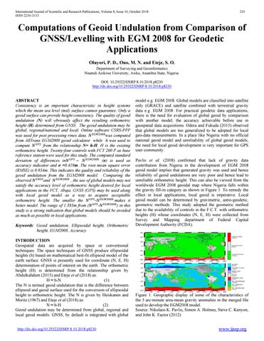
model e.g. EGM 2008. Global models are classified into satellite only (GRACE) and satellite combined with terrestrial gravity data e.g. EGM 2008. For practical geodetic data applications, there is the need for evaluation of global geoid by comparison with another model, the accuracy achievable before use in geospatial data acquisitions. Odera and Fukuda (2015) observed that global models are too generalized to be adopted for local geo-data measurements. In a place like Nigeria with no official national geoid model and unreliability of global geoid models, the need for local geoid development is very important for GPS user community. Pavlis et al. (2008) confirmed that lack of gravity data contribution from Nigeria in the development of EGM 2008 geoid model implies that generated gravity was used and hence reliability of geoid undulations are very poor and hence lead to unreliable orthometric height. This can also be viewed from the worldwide EGM 2008 geoidal map where Nigeria falls within the gravity fill-in category as shown in Figure 1. To remedy the effect in local applications, local geoid is imperative. Local geoid model can be determined by gravimetric, astro-geodetic, geometric methods. This study adopted the geometric method due to the availability of controls in the F.C.T. with orthometric heights (H) whose coordinates (N, E, H) were collected from Survey and Mapping department of Federal Capital Development Authority (FCDA).
Figure 1. Geographic display of some of the characteristics of the 5 arc-minute area-mean gravity anomalies in the merged file used to develop the EGM2008 model. Source: Nikolaos K. Pavlis, Simon A. Holmes, Steve C. Kenyon, and John K. Factor (2012) www.ijsrp.org