How This Came to Be
The tide was rising fast, lapping against the rim of my tyres. The beach sand was collapsing under the weight of my Landcruiser. I was alone for nearly a hundred kilometres in every direction. "Oh gee, James." I said to myself, "how do you get into these situations!" It was the end of April 2021. I was halfway through a 110,000km trip around Australia mapping indigenous song lines. I was driving south from the Eyre Bird Observatory down the beaches of the beautiful and remote Nullarbor Coastline.
I grew up in Melbourne, with parents who liked to explore. Holidays were hours of car cricket as we drove west to the Flinders, north to Mungo, further north to the Dig Tree and more. Weekends were filled with sport, fishing trips, bird watching or tracking down historic buildings and gardens. I was fascinated by the natural sciences and history but mostly by explorers. Mawson, Ranulph Fiennes and Jacques Cousteau were my poster heroes.
I graduated with degrees in Earth Sciences (Geology), Economics and Polar
Studies and then worked as an explorer looking for resources across the deserts of Central Australia, the Pilbara and Bass Strait as well as other countries.
Over the years my interests and skills grew. Mountaineering, scuba diving, sailing, paragliding, hiking, biking, 4WD, rock climbing, canoeing, birdwatching, dendrology, climatology, oceanography and more. I climbed the seven summits, skied to the poles, sailed oceans and crossed many deserts. I travelled extensively with my five children although I admit that I am probably more excited than them at seeing the Devonian Buchan limestone caves or the Ochre mines in the MacDonnell Ranges. I am a single Dad and take them where ever and whenever I can.
My car and bookshelves are full of Hema maps, guides and other books. My walls are covered in maps and new routes and places to discover. I realised that most books are specialised whereas I want to see and do it all. So, I created my own lists of things to see and do in the countries and places I went. I
gathered these from many sources and discussions with other explorers.
As I travelled around Australia I realised two things;


1 Many of the places I would only visit once in my lifetime so I didn’t want to miss out on “the best beach/view/drive/ hike" because I didn’t know that it was there.
2 With a simple, easy-to-follow map with dots, I could get more people out to see these incredible places and hopefully raise awareness of the importance of protecting them for future generations.
I hope that you enjoy this first edition. There are thousands of activities to see and do and there are equally thousands more that I have left out. I hope by using this book you’ll be able to spend more time doing and seeing and less time researching. A big thank you to the Hema team for making the book professional with layout, editing and brilliant maps.
Have a wonderful time exploring our
3
1st Edition
Compiled by James Allen EXPLORER
Things to see and do
We have over 3000 activities to suit all types of explorers
Creating a book of things to see and do is extremely subjective. It’s judged through my eyes and my interests. Many of the top 10 per state are obscure. Some of them don’t even have plaques telling you what is there yet I’ve included them because of the thousands of places I have seen they represent the best, the most interesting in their category in that state. Additionally, travelling with kids presents a whole range of entertainment challenges. So I’ve included simple things like where are the best playgrounds, waterparks, museums, beaches, walks and snorkelling with kids.
I have also deliberately left out a few incredible places to help preserve them. While I wanted to include as many indigenous cultural sites as possible I have been particularly careful to only include sites that have been published and authorised for visits. Nevertheless,
please be respectful of the sensitivity around visiting and photography at these locations.
While the general idea of the book is one book for a “big lap” style tour it is also designed to use to discover many things in your local area. I have left off a number of longer multiple-day trips in preference for more shorter and more readily accessible walks and features.
I do need your help though. I will get things wrong. Site access will change, facilities improved and some awesome places I may have missed. Scanning the QR code will take you to a simple page where you can record the changes to be included in edition two.
My main aim of this book is to help you spend less time planning and more time doing as you travel around Australia. Have an awesome trip and I look forward to hearing from you as you explore more of

UPDATES AND ADDITIONS
We would love to hear about your adventures and any updates or additions to activities you have discovered.
Just scan the QR code below and fill in the form.

How to use the Quick Reference index
Indigenous Culture
Defined as any location or activity where there are indigenous experiences, indigenous art or indigenous history.
Natural Wonders
Defined as any location or activity which is purely nature with no or limited influence by humans, eg, geology, fossils, forests,
waterfalls, coral reefs, beaches, animals and sunsets.
Man Made Landmarks
Defined as any location or activity where there is a man made component to that thing to see or do, eg, classic drives, museums, botanical gardens, lighthouses and historic monuments.
Combination
Many activities have a combination of types of activities, eg: Uluru has geology (nature), Indigenous art (Indigenous) and walking tracks (man made). In these cases I have given the headline map location colour the following priority: Indigenous first, then Natural then Man Made.
5
T P 10 James’
1. Lone Gum, Coolabah Tree, Simpson Desert
How trees of this size survive out here is incredible. Its not so much about the destination on this one but yes, you guessed it, its about the journey. Whatever route or line you travel to get to this point will be memory that last a lifetime. If you can, time your trip to see the desert wildflowers. (Page 251)
2. Strezlecki Track
Weaving through the desert from the Flinders Ranges to Innaminka. I prefer the North to South route watching the Flinders appear then fill the horizon. (Page 252)
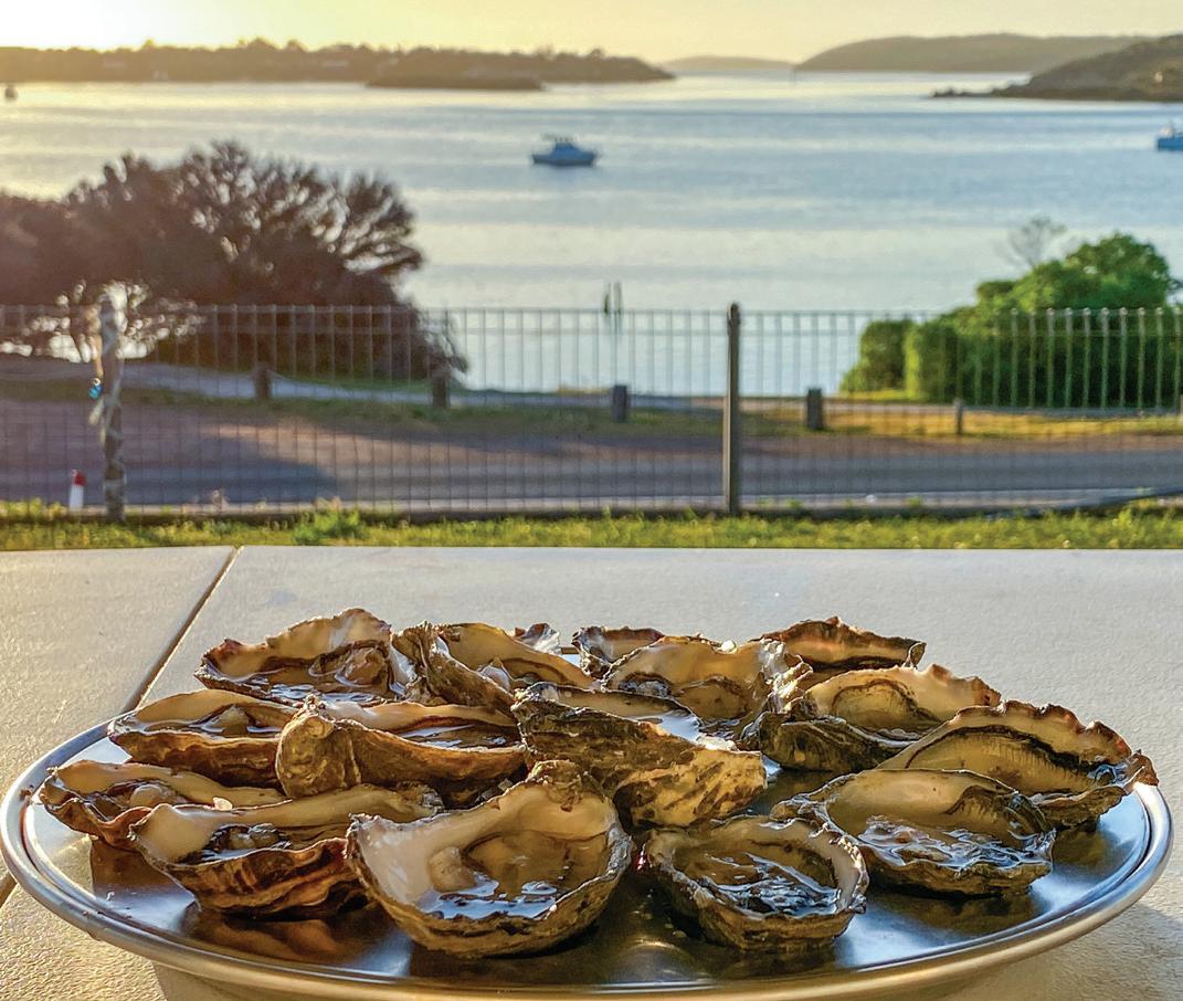
3. Coffin Bay Oyster Trail
South Australia is food and wine and this is my top pick in that class across Australia. None did it better than these guys. Great total sensory immersion experience for kids and adults. (Page 253)
4. Mawson Trail
A long distance and remote mountain bike trail though spectacular country. Uniquely Australian. (Page 263)
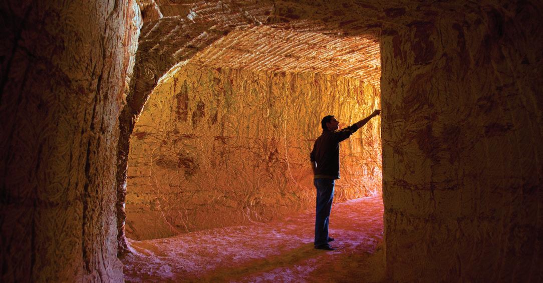
5. Coober Pedy
Mining and their towns are part of Australia’s history, non more so than here. It is easy to imagine the harshness and joy of outback life here in this town. (Page 250)
6. Arkaroola Wilderness Sanctuary Resort
Crystals and stars. Lots to discover and explore in this northern part of the Flinders Ranges. (Page 250)
7. Barossa Valley
I love a good Australian shiraz and its home is here. No trip to South Australia is complete without a cellar-door tasting or three. It’s like a massive drive through bottle shop to supply the rest of your journey…well at least until the Margaret River, Yarra Valley or Hunter Region. (Page 258)
8. Blue Lake, Ewans Ponds Conservation Park, Mt Gambier
Kids and adults can discover cave snorkelling and diving in these crystal clear waters. For more advanced divers check out Kilsby sinkhole. (Page 260)
9. Cordillo Downs, Sturt Stony Desert
A stunning drive with an incredible pioneering history of sheep, dingoes and hard working Aussies. (Page 250)


10. Yalata/Fowlers Bay
The lessons learned of how we treated our fellow Australians should never be forgotten and never be repeated. (Page 255)
6
THINGS TO SEE & DO 8 SA
5 Clare Valley
The Clare Valley is a gourmet travel destination with an emphasis on wine. The region is known as a premier grower of Riesling grapes. Walkers and cyclists can enjoy the aptly-named Riesling Trail, that tours the area’s small towns along the course of an old railway.
Activities Listings
6 Barossa
257
This world-renowned wine-making region is a Shiraz grape mecca with a strong blend of German and English heritage. The area combines a traditional feel with the comforts of modern luxury, in equal parts family-friendly activities and romantic retreats.
Activities Listings
7 Riverland
258
Some of the finest stretches of the Murray River can be found in Riverland, as it traces along the edges of the Murray River National Park, cutting a deep path east before turning south. It’s a popular area for water sports and is frequented by four-wheel drivers and trail bike riders.
Activities Listings
8 Murraylands
258
Murraylands covers the lower part of the Murray River Basin, as the waterway travels south towards Lake Alexandrina and the coastline of The Coorong. The region can be explored by road or from a houseboat and when it’s time for a change of pace, water-skiers and
wakeboarders will be in their element.
Activities Listings 258
9 Limestone Coast
There’s much more to the Limestone Coast than meets the eye. The southern coastline is dotted with surf breaks and sheltered beaches, while flat inland expanses are punctuated by picturesque agricultural towns. Below the surface are a series of limestone caves and subterranean lakes that are a must-see for any visitor to the area.
Activities Listings 259
10 Adelaide
South Australia’s capital is a diverse city with healthy industrial, cultural and historical sectors. Its proximity to local wine and produce regions makes Adelaide an easy place to indulge, while

historic buildings, parks and botanic gardens provide ample opportunity to walk off the day’s excesses.
Activities Listings 260
11 Adelaide Hills
A short drive from the big city, the Adelaide Hills are an easy escape for those in need of some fresh air. This region is peppered with vineyards and quaint cellar doors, as well as plenty of luxurious boutique accommodation, caravan parks and campsites to choose from.

Activities Listings 263
12 Fleurieu Peninsula
A land of coastal culinary delights awaits on the Fleurieu Peninsula, with succulent seafood and award-winning wines aplenty. Beach-lovers will find what they’re after at
CLOCKWISE FROM ABOVE: Boat sheds on the Torrens River, Adelaide City; Colourful vineyards, Barossa Valley.
9 SA
C
Lake Albert, Wagga Wagga
One of Wagga's most popular recreational facilities. ///greet.louts.residences 154 C2, 157 E14
O b e Q W 681
683
683.1
A
Cristo Homestead
Rock Nature Reserve
Recognised as Australia's Most Haunted homestead. ///earlier.genetic.martini
B A
Trail Cultural 42-kilometre loop around the city. ///tonight.skews.dent
Big Murray Cod, Tocumwal
A
///mitigating.shackles.beads
A
///tinkle.nourishing.grad
154 C1, 157 E13
157 C11
I W B
157 A10
154 B2, 157 E14
157 H8 -35.8116635 145.5639888 L p K
e
J13
F6
157 F10 -35.3363746 146.2710022 K p 693
A Wagirra Trail & Yindyamarra
Walk
157 J13
150 F5 -33.97754 142.98755 C J H 695 A Yarkuwa
Indigenous Knowledge Centre
cultural centre of family histories and photos.
Peak & Carruthers Peak
highest mountain in Australia (2 145m). ///fluffs.dishwater.aimed
C5
158 D1
Seventh
680
-35.1679848 147.3736675
Monte
-34.8683295 147.575894
154 A3
H 682
Kengal Aboriginal Place offers walking, picnicking, birdwatching and rock climbing. ///fluoride.heatproof.laugh -35.2751971 147.0760377
-34.7504438 146.5342641
Sandhills Artefacts Hand crafted Aboriginal cultural items. ///suits.renaming.swindled
C B
H
-34.3501686489999 146.041922246
684 Wiradjuri
-35.11269 147.37452
685
The Big Wine Barrel Used as the entrance to a Winery and Cellar Door. Pleasant surrounds ///fizzed.unimpeded.unpaid
K K p
C B H c
686
This fish represents what the area is most famous for. ///sirens.shelves.convoluted
A Edward River Canoe & Kayak Trail
156 H6 -35.7887387 144.9653817 C 2 Q 687
Mungabareena
Great paddling spot with camping, picnic, and swimming. ///shape.banner.necklaces
Reserve, Albury
154 G1, 157
-36.0913477 146.9551742 C H 688 A Mungo Foreshore Walk
150 F5 -33.7184885 143.0238888 W H 689 A Mungo National Park & Lunette Oldest
///stand.durations.consisting 150 F6 -33.7600797 143.0969442 C I O D H
Important cultural reserve, significant to Indigenous people in the area. ///spoiler.deform.puts
A moderate 3.4-km loop near Mungo ancient dry lake takes 40-min.
skeletons found in Australia Mungo Lady & Mungo Man (c42 000 yrs).
690 NSW Central
11. THE MURRAY
Murray Forests
156 H6 -35.77744 144.98149 F B 691 A Perry Sands, Wentworth
///rudest.misfortune.scenic 150 G3 -34.1012511 141.867067 B I W 692
Red
150
-33.7879375 143.1131875 O W 692.1
Key forest areas: the Millewa, the Werai and the Koondroo.
Ancient
shifting sand dunes which include Aboriginal cultural heritage areas.
Top Lookout View of the erosion on Mungo’s landscape and the drying Willandra Lakes. ///skipped.lasting.institutes
The Big Spider
Sculpture
Suspended from the town's water tower. A beauty ///restoration.resize.expansions
154 G1,
-36.0872323 146.8877871 B W 694
Sculptures by local Aboriginal artists line the 5km trail. ///will.active.glitter
B Willandra Lakes Region
Indigenous Aboriginal
///pamper.stoves.internship 156 G6 -35.5342116 144.9664762 C H 12. SNOWY MOUNTAINS 696 A Abbott
Ninth
154 H5,
-36.4099613 148.2908907 I W 697 Adelong
154
-35.2961843 148.0568911 I P Q
698 A Alice
154 H5 -36.4158133 148.2636475 I W
James’ Top 10
Indigenous Culture Natural Wonders Man Made Landmarks 10 NSW
UNESCO Heritage site: 60 000 years of Indigenous history & giant marsupial fossils. ///shimmers.remember.wooded
Falls, Gold Workings Reserve Perfect for history buffs & a popular swimming hole in summer. ///portraying.counted.bikers
H
Rawson Peak
highest mountain in Australia (2 160m). ///constructs.messed.impacts
per State A Best of the Best B Kid friendly
B A
Big Trout, Adaminaby A 10-m fibreglass fish built in 1973 & one of more than 150 Big Things. ///deductions.isolated.custody
A Blue Lake, Kosciuszko National Park
A
A
One of only four glaicial cirque lakes on the mainland. ///supervises.grouped.couches
Cart Trail Easy 4wd dry-weather-only trip of 270 km. ///regress.handing.cheek
Charlotte Pass Walk, Kosciuszko NP
Plain Karst, Kosciuszko National Park
A
All-day walk with views of three lakes, climbs Mt Kosciuszko and crosses the Snowy River twice. ///browns.converting.rental
These limestone features formed about 420 million years ago. ///fluid.computers.liable
Ginini Flats Wetland Complex The Ginini Flats Wetland complex is listed wetlands of international significance under the Ramsar convention. ///opportune.wildfires.kings
Walk An easy 5km return walk through Kosciuszko NP. ///gloomy.pining.topmost
Alpine town on Lake Jindabyne, at the edge of the Snowy Mountains.
A Lake Jindabyne Built in 1967 and one of sixteen dams in the Snowy Mountains hydro-power scheme.
Self-guided tour around some of Cooma's historic landmarks.
challenging 24km hike for fit walkers, it takes 7 hours.
Plain The Monaro Plains are part of the tablelands of the Snowy Mountains alpine region. ///lacked.partied.hems
Gates Class IV white-water rapids with a 23km technical ride. ///ritually.hollow.saddle
River Dam Beautiful bush camp beside a small trout dam in Bago State Forest.
Walking Track A popular walk for fishing and picnicking by the river and birdwatching. ///polite.reissued.breastfeed
The southern hemisphere's largest snow resort. ///rebuffed.gladiator.fleshy
Phillip Trail East-west drive in the High Plains of Kosciusko NP. ///unaware.recite.spilling
Head Fourth highest mountain in Australia (2 190m). ///remit.bookseller.congestion
H6, 158 D2
699
159 K2 -35.9973022 148.7745783 L
700
p K e
154 H6,
-36.4043142 148.3153717
701
159 E1 -35.4653244 148.5983837 4 702
158 D1
I B
Broken
154 H6,
-36.4318413 148.3286239
703 Cooleman
158 D1
W
159 G2 -35.6531432 148.700445
704
159 F2 -35.5165837 148.7666587
705
Illawong
154 H6,
-36.3877727 148.3634397
706
Jindabyne
154 H7,
D2 -36.4172451 148.6248294 O e 5 9
707
///evolve.practitioner.drones 154 H7,
D2 -36.3722118 148.6286836 I b e 708 A Lambie
Cooma
///bloodshot.eardrum.sentencing 155 G8, 158 C3 -36.2322279 149.1147328 H W 709 A Main Range Track, Kosciuszko National Park A
154 H6,
-36.418821 148.311396 I W 710 Monaro
155 H9, 158 D4 -36.4310826 149.2382744 I 4 711 C Mt Kosciuszko Australia’s
154 H5 -36.4558975 148.2635987 C I H W 712 A Mt Northcote Tenth highest mountain in Australia (2 131m). ///groovy.tell.faultless 154 H5, 158 D1 -36.4298242 148.2789332 I W 713 A Mt Townsend Second highest mountain in Australia (2 209m). ///supersonic.cockiness.asparagus 154 H5 -36.4227655 148.2587273 I W 714 A Mt Twynam Third highest mountain in Australia (2 195m). ///starring.fishing.titled 154 H6, 158 D1 -36.3928456 148.3153112 I W 715 A Murray
154 H5 -36.4645415 148.1369271 C 2 716 A Paddys
///weekdays.gallery.hypothetical 154 E5 -35.712713 148.168078 4 e 717 A Pallaibo
154
-36.3660625 148.5735625 W e 718 Perisher
154 H6,
-36.4055484 148.4094358 C I H 719 A Port
159 H1 -35.713954 148.6282242 4 720 A
154 J5 -36.5152778 148.2347222 I W 721 A Rams
154 H5 -36.4877777 148.2612857 I W 11 NSW
I
B
158 D1
W
B A
///compulsory.sharpens.supermarkets
158
W
158
Town Walk,
///earl.hindering.signposts
158 D1
highest mountain (2 228m). ///scales.nurse.digging
158 D1
Rams
Head North Sixth highest mountain in Australia (2 177m). ///verifying.squadrons.sponge
p p p p p p p p p p p p p p p p p p p p p p p p p p p p p p p p p p p p p p p p p p p p p p p K K K K K K K K K K K K K K K K K K K ! ! ! ! ! ! ! ! ! ! ! ! ! ! ! ! " " " " " " " " " " " " " " " " " " " " " " " " " " " " " " " " " " " " " " " " " " " " " " " " " e For more detail see Hema s South West Western Australia map To C o olgardie To Menzies To Narembeen To Corrigin L L L L L L L L L L L L L L L L L L L L L L L L L L L L L L L L L L L L L L L L L L L L L L L L L L L L L L L L L L L L L L L L L L L L L L L L L L L L L L L L L L L L L L L L L L L L L L L L L L L L L L L L L L L L L L L L L To Mount Magnet To Sandstone To Sandstone 49 144 173 147 293 L 4 6 7 7 7 8 13 9 9 9 18 51 10 10 14 20 11 11 11 11 11 11 18 12 12 47 2 3 12 2 1 13 13 3 1 13 13 14 29 4 1 14 14 14 15 14 14 15 15 15 15 42 15 15 16 16 16 6 1 16 16 16 17 8 1 18 17 18 18 18 18 18 18 19 19 19 19 29 0 2 20 21 20 20 21 21 21 42 21 21 21 21 23 21 22 23 22 3 2 22 22 23 23 23 57 30 24 24 24 25 25 25 25 25 25 25 25 25 26 26 27 8 2 85 28 28 8 2 28 29 30 35 43 31 30 31 31 32 32 33 32 32 33 36 35 5 3 38 37 36 38 37 38 39 9 3 0 4 1 4 41 42 42 43 43 43 43 43 44 6 4 49 50 50 59 60 60 63 61 60 62 3 6 67 68 69 72 80 92 99 99 1 0 4 9 Warning to travellers This area is continuously baited with S7 "1080"baits that are lethal to cats and dogs. Muzzle domestic dogs in this area. t t t t t t M M M M M M M M M M M M M M M M M M M M M M M M M M M M M M M M M M M M M M S a l t R W a r ne R. Lake Giles Lake Eva Lake Julia Barker Lake Lake Baladjie Lake Walton Lake Campion Lake Harvey Hamersley Lakes Mollerin Lake Lake Seabrook Lake Deborah East Lake Wallambin Lake Deborah West Lake Noondie Lake Moore Lake Barlee Lake Barlee Springwell Valley Auriferous Island Mount Richardson 554m Mount Forrest 560m Mount Walton 523m South West Peak 570m Mount Mason 566m Mt Ida 560m Mount Geraldine 642m Deception Hill 516m Yagar 532m Mount Dimer 510m Bungalbin Hill Yenyanning Hill 530m 615m Mount Alexander 510m Pvt. Pvt. Pvt. Pvt. Pvt. Pvt. Pvt. Pvt. Pvt. Goldfields Woodlands NP Boorabbin NP ex Credo Yellowdine NR Yellowdine NR ex Cashmere Downs (proposed for conservation) Ninghan IPA Karroun Hill Nature Reserve ex Jaurdi ex Ennuin Walyahmoning NR Geeraning NR Chiddarcooping NR Baladjie Lake NR ex Mt Elvire Jilbadji Nature Reserve Mt Manning Conservation Park Mount Manning Range Nature Reserve ex Bulga Downs (proposed for conservation) E m u F e n c e Rd Job Rd R em la p R d Patroni R d Mount W a l t o n Road Dulyalbin Rd S o u t h e r n C r o s s South Rd Bimbi y R d Bu l l finch Evanston Road C a s h m e r e Downs Rd Meranda North Rd Scotsman Road ekaL B a r l e eYouanmi Road Angle R d Baker Rd Mo r i s o n R d Garbin R d Kent Rd v e y Rd d R y e l a V o h c E N o o n g a r N o r t h Rd B o d a l n N o r t h R d Mount Jackson Rd Mount J ack son Rd d R k r a l C Kwoly in W e s t R d L ak e B a r l e e Rd M o u r o u b r a Menzies-SandstoneRd Menzies-Sand stone Rd Paynes Find Sandstone Road R d Emu Fence R d Road Moo r i n e South Trans Au s t r a l i a n R a i l w a y Koorda - Bullfinch Rd B o nni e R o c kW i al k i Rd M u k i n budin Rd Bruce Roc kM rre e dinRd Great htroN nre Hwy Eastern Hwy Great Eastern Hwy A A 94 A A 94 A A 95 'Kirkalocka' Narndee' 'Lake Barlee Mount Jackson' 'Perrinvale Outcamp 'Boodanoo 'Mount Elvire 'Cashmere Downs' 'Meeline' 'Diemals' 'Wills More Outcamp' 'Wydgee 'Nalbarra' 'Bulga Downs' 'Ennuin Mount Hampton' '45 Mile Outcamp' 'Remlap' 'Trelawney' Mangowine 'Gimlet Park' 'Mount Lookout' 'Hill View Park' 'Windy Ridge' Wattle Hill' 'Oudabunna' 'Goodingnow' 'Yuinmery' 'Pullagaroo' 'Youangarra 'Pindabunna 'Ida Valley' 'Walling Rock' 'Carinta 'Jaurdi' 'Euroa 'Wilbah Outstation' 'Karloning' 'Neening' Jilbadgie' 'Maranalgo' 'Bimbijy Youanmi Downs' 'Mouroubra 'The Rock' Booraan Boondi South Trayning Mulline (abandoned) Youanmi (abandoned) Eyanning Yelbeni Boorabbin Chandler Cleary Paynes Find Kwelkan Yellowdine Kwolyin Beacon Baandee Wogarl Muntadgin Cramphorne Welbungin Moorine Rock Trayning Marvel Loch Holleton Jelbercuting Erikin Barbalin Bencubbin Bungulla Hines Hines Hill Walgoolan Carrabin Bodallin Garratt Corinthia Lake Brown Noongar Warrachuppin Warralakin Bullfinch Boodarockin Baladjie Burracoppin Shackleton Yoting Eujinyn Nungarin Wialki Bonnie Rock Nukarni Westonia Doodlakine Kununoppin Southern Cross Kellerberrin Bruce Rock Mukinbudin Merredin 'M ul garo ona Outc am p' (aba ndo ned) Mo un t Ida (aban don ed) Kooly anobb ing \ Access to track parallel to railway line is restricted. Permission is required from Westrail to access Gullyvye Pool Ward Springs Thugaroo Spring Nungajinny Pool Bayes Soak Bunao Rockhole Jiljinny Pool Merbine Waterhole Djua i Rockhole Gabito Spring Budnee Dam Pulcher too Spring Gingier Pool Croobenyer Rockhole Candierring Rockhole Goonabbery Spring k s i r n o s i o p 0 8 0 1 –g n n r a W Warning–1080poisonrisk Datjoin Well Rainy Rocks Kurrajong Gorge Trayning Gnamma Holes Holland Track Centenary Plaque 206 221 # 332 # 330 # 329 # 343 120°30'E 120°30'E 120°E 120°E 119°30'E 119°30'E 119°E 119°E 118°30'E 118°30'E 118°E 118°E 28°30'S 29°S 29°30'S 30°S 30°30'S 31°S 31°30'S 8 8 9 9 10 10 11 11 12 12 13 13 14 14 K J H G F E D C B A 17 1 W A © Hema Maps 13 WA
3001

things to see & do aroundAustralia


Prepare for your next adventure with the 3001 things to see & do around Australia from Hema, Australia’s premier producer of off-road and touring maps and guides. Travellers can browse comprehensive activity listings, split into 75 regions across all states and territories, or select activities along their path using detailed Hema Maps. The listings are categorised as indigenous culture,
Compiled by James Allen EXPLORER
natural wonders and man made landmarks, making it easy to find the perfect destination, while an intuitive design ensures stress-free trip planning. And it’s all backed up with over 20 years of fieldwork by the Hema Map Patrol.
This ultimate TRAVEL GUIDE includes:
• Over 3001 indexed activities, grouped into 75 regions
• 180 pages of maps showing activity locations
• Listed by state, territory and region for easy navigation
• James’ Top 10 per state, best of the best activities and kid friendly fun
• Islands around Australia
Listings are simple and intuitive, making it easy to locate a specific activity or browse for something unique
• History, culture and exploration
• Intuitive, easy to use design
• Exploration and travel tips
Colour coded activity listings:
Indigenous Culture
Natural Wonders Man Made Landmarks
1st Edition
www. hemamaps .com Prepared to explore Queensland Regions 1 Tropical North From the Daintree Rainforest to the tip of Cape York, Tropical North Queensland never ceases to delight. Skirted by the diverse Great Barrier Reef and filled in with red dirt, the entire region is packed with bucket-list experiences. A trip to the Tropical North is one that won’t soon be forgotten. Activities Listings 21 2 Outback Queensland Remoteness takes on a unique charm in the vast expanse of Queensland’s Outback. As visitors push deeper into the unknown, more and more unusual delights will be discovered. Set coordinates for the iconic Birdsville Hotel for a once in a lifetime trip. Activities Listings 27 3 Northern Queensland The area that sits on the northern end of the Great Dividing Range contains an array of major river systems that branch into World Heritage rainforest, irrigate large sugar cane plantations and push nutrients out into the teeming seas. A truly spectacular region without the remoteness of the Tropical North. Activities Listings 29 2 4 5 9 4 Whitsundays The Whitsundays are one of Australia’s picture-postcard destinations, thanks to their quintessentially pristine beaches and untouched wilderness. Airlie Beach is the primary jump-off point for the islands, which are best explored on a sailing yacht with no hard and fast itinerary. Activities Listings 30 If you think the Whitsundays look stunning on the page, just wait until you see them in person. LEFT TO RIGHT Elliot Falls, Cape York; Idalia National Park’s Wave Rock, Outback Queensland. 16 QLD Incorporating /// what3words locator system p p p p p p p p p p p p p p adura 9 11 13 109 16 17 23 25 26 27 28 38 31 33 33 38 50 50 52 59 60 65 66 66 67 118 148 156 1 t t t t t P v Lake Daringdella Lake Dover Point Culver Malcolm Point Dempster h H m d Cundeelee Mission ALT Nu R e e Haig (siding) Ov g wn e t P t P P vt. vt. Public Access Public Access C ed C dd R n R a a a oR w a R M c m dR d R Ey H G r e a t A u s t a a n B g h t Israelite Bay T wilight N a r b r P a n A A A A x h D B h d d W d B y b k b d ed Ngadju IPA Ng Ngadju IPA 'Pondana' 'Nanambinia' d a 'Kinclaven' 'Seemore Downs' A B 'Balgair' 'Woorlba' 'Gunnadorrah' d h R 'Noondoonia' C b dd Links Hole 10 (Eagle's Nest) Ro Bu ( u Zanthus Rawlinna Caiguna y A n d b W n b a \ S h g d\ A dy track becomes difficult to follow it traverses Rawlinna Station and it may be best to take the Haig route Rawlinna instead. As courtesy, contact Arubiddy Station (Ph 08 9039 3451) before using the track from the Eyre Highway to Rawlinna. \ o Balladonia Road remote and unmaintained track which may be closed from time to time by the Shire of Dundas due poor conditions. Contact the Shire of Dundas on 08 9039 1205 or the Visitor Centre 08 9039 0040 road conditions prior to considering to travel. x s y d a k p b R Rockhole k W d Oodlegabbie Rockhole b W –1 8 pi k h b d g y E p d 1 7 n d h d O y y N h d d d g y C W b Baxter Caiguna Blowhole Nullarbor Links Hole (90 Mile Straight) Baxter Longest straight of road Australia 146.6km Ways Israelite Bay Loading Jetty (abandoned) C Eyre Bird Observatory h Edward Eyre and co. memorial plaque NullarborHole 12 (Skylab) Balbinya Homestead (built in 1883) D Toolinna Rockhole e more detail Nullarbor Plain map 169 209 # 333 # 333 8 8 9 9 10 10 11 11 12 12 13 13 14 14 K J H G F E D B A 126°E 126°E 125°30'E 125°30'E 125°E 125°E 124°30'E 124°30'E 123°30'E 123°30'E 31°S 31°30'S 32°S 32°30'S 33°S 33°30'S 34°S 157 WA © Hema Maps p p p p p p p p p p p p p p p p p p p p p p K K Menzies L L To w To Lake King To Lake King 5 7 8 33 8 9 10 13 11 12 12 12 13 13 13 13 13 13 14 14 14 14 15 16 16 17 16 17 18 18 18 44 19 19 58 9 19 20 21 21 21 22 22 23 24 24 24 39 25 26 26 27 26 27 27 28 27 27 27 29 30 1 34 43 34 34 36 36 69 37 61 40 41 41 57 42 45 45 4 46 47 48 48 51 50 51 56 56 62 66 83 68 91 79 80 120 99 106 38 54 293 10 185 188 1 W g s area is continuously baited with S7 "1080" baits that are lethal to cats and dogs. Muzzle domestic dogs this area. t u u u u t t t t t t t t t t tt t t t t t t t t M M M M M M M M M M M M N Mungliginup W Peters Nancara Rockhole Dingo Rockhole Capewelluck he u w W C u ayCh Odf R Lort R. P The Dog Gap p C R k Rock h B Bronco Plains Em Hampton Plains Mt Pleasant Peak Charles Peak Gilmore Pyramid Lake Lake Mends Lake Roe k Lake Tay L J e a Lake Dundas Lake Cowan Middle Island North Peak Mondrain Woody Is Figure of Eight Island Frank Hann National Park NP Cape Le Grand NP Helms Arboretum Yallari Timber Reserve Cu de M on Cape Arid National Park Peak Charles Nat. Park Goldfields Woodlands National Park P m R Permit Dundas Nature Reserve Karu Goldfields Woodlands CP Clyde Hill NR Beaumont South NR Ridley Neredup NR Niblick Alexander Truslove Townsite Shaster NR Nearnup NR Cheadanup NR Griffiths NR Griffiths NR Kangaroo Fields Wallaby Timber Res. Coonana Timber Res. Rocks Timber Randell Timber Res. Road H - d Road D R Field Road S d M g S u Rollond k a P m go M G G A R H o Muntz Road W o d e R o S H Styles Rd d Fisheries Road d M Mo S B a R Rd t d d Baldona R Lake King Norseman Road C s de Norseman Road Road HydenVc a Rock Nepean- Spargoville Rd me Sp fxR nge Fase Range Permanently A c h p g o o f t h e R e h e c h e R Esperance Bay d A Ngadju IPA Ng d PA C a Hw Eyre Hwy G o H Ge t Ea en pe e H w y Co gard Hw C ogadEsperance A A A A A A 'Fraser Range' 'Warriup' 'Madoonia Downs' B a W 'Mt Monger' 'Benelong' B A o 'Jenabillup' M g F d A hg W U d 'Southern 'Cataby' M 'Rangitoto' C 'Kappi Ki' 'Macsfield' 'Woolibar' Sh Lu 'Nurragi' 'Munglinup Station' O s m A Kurrawang Tjirntu-Parapara Ninga Mia Village (Ninga Mia) Upurl Upurlila Ngurratja Coonana Boy p Bullabulling ( b d d ( b d nd Lakewood (ruins) Widgiemooltha C a b p Gibson Scaddan Dalyup Mu g p Condingup Cascade Shark Lake Higginsville Wallaroo Curtin Wharton Ea M g G m Grass Patch B a up Binneringie Dundas Norseman Coo ga d Kambalda K mba d W s E p ance Ka goor e-Boulde Golden Ridge (abandoned) \ d T o h n 5 h 39 0 p – 1 p k Newman Rock Dundas Rocks Links Holes (Golden Horse & Ngadju) Nullarbor Hole 13 (Sheep's Back) F Hill Springs Whistling Old Train Carriage Nullarbor Links (Silver Lake) Peak e For see Hema's Nullarbor map 175 188 173 176 177 184 197 201 232 172 180 183 186 189 190 200 202 204 207 218 222 224 229 179 237 239 223 212 219 240 # 332 # 329 # 345 1 1 2 2 3 3 4 4 5 5 6 7 7 K J H G F E D C B A 122°30'E 122°30'E 122°E 121°30'E 121°30'E 121°E 121°E 120°30'E 120°30'E 31°S 31°30'S 32°S 32°30'S 33°S 33°30'S 34°S 156 Kalgoorlie-Boulder to Cocklebiddy WA V 330 WA 331 WA C James’ Top 10 per State A Best of the Best B Kid friendly Indigenous History Natural Wonders Man Made Landmarks 166 VIC 1. MALLEE Big Lizzie Fascinating history of a real working BIG Thing. One of a kind. ///pastries.dapper.trim 200 D6 -34.3078868429999 142.186849437 K H K p 1.1 Hattah-Kulkyne National Park Lies in rolling sand hills, with Mallee scrub & open native pine woodland. ///benefactor.desk.chummy 200 G7 -34.7556363 142.3395402 B W 2 Kerang Wetlands Ramsar listed wetlands, with dozens of species of waterbirds, on fresh & salt lakes ///title.bowhead.growers 199 E11 -35.599948 143.8227045 B 3 A Kings Billabong Nature Walk Experience a Mildura Cabernet & regional delights while on the walk. ///polling.putter.sandals 200 D7 -34.2256227 142.224015 B W 4 C Murray-Sunset National Park One of the few remaining semi arid regions in the World where the environment is relatively untouched. ///orchid.wingspan.udder 200 H4 -35.0396448 141.7199585 C I D H 5 B A Swan Hill Visit the Heatbeat of the Murray light show, at the Pioneer Settlement. ///confuses.essence.insight 199 D10 -35.3396318 143.5524803 E H 6 5.1 The Big Mallee Root Obscure, but real and life-sized. This is the world record holder. ///doorways.upside.pasture 200 J7 -35.0726437169999 142.319073273 K K p 5.2 Big Mallee Fowls A pair of 3m high birds, doing what they do best: scratching ///dexterity.barrels.stupidly 198 D6 -35.3830958269999 142.189420577 K K p 6 A Brim Silo Art Painted by Guido Van Helten the silos depict local farmers. ///sadness.skinny.fearless 198 G6 -36.078345 142.4210656 A 7 Lake Albacutya Park Ramsar listed lake, great for birdwatching when full (the Wimmera River empties into here). ///forks.fearless.smirking 198 F5 -35.7475839 141.9685998 B W 8 C Lake Tyrrell Victoria's largest salt lake & great for photography. ///fitting.divided.sunflower 199 D8 -35.3479943 142.8321695 I M O p 8.1 The Mallee Bull Plenty of local folklore with this revered old fellow. Nice park, lovely town ///tango.upstate.improvements 199 G8 -35.9821003119999 142.917615976 K K p 9 A Wyperfeld National Park Central feature is chain of lake beds connected by Outlet Creek. Lookout for Mallee Fowl ///plonk.joked.contributed 198 E5 -35.5865135 142.0511392 W 10 Bunjil's Collective Indigenous Art Gallery & Gift Shop; Horsham Gift shop ///unzips.plaque.armrests 196 A6, 198 K6 -36.7124802 142.198462 B A 11 A Byaduk Caves Located in the Mt Napier state park the caves were formed by lava flows. Take a torch. ///antics.nicknamed.recipient 196 F5 -37.8964919 141.9710926 D I 12 B A Giant Koala, Dadswell Bridge Completed in 1988, this BIG THING contains a souvenir & gift shop ///mixing.satins.hands 196 B7 -36.9183019 142.5140008 L 13 Harrow Discovery Centre Home to Johnny Mullagh & the story of the first cricket team of 1868. ///microwaves.thundering.courier 196 C3 -37.1659673 141.5925553 C H 15 A Lava Blisters/ Tumuli One of only three sites in the world where tumuli (lava blisters) exist. ///fundamental.toucan.scratch 196 F4 -37.9376673 141.8850471 I 16 A Mount-ArapilesTooan State Park Rises sharply from the Wimmera plains & is great for rock climbing. ///flask.thinly.monochrome 196 A4 -36.786039 141.7150537 C I H 5 I 2. WIMMERA 3. WEST GRAMPIANS


 Dive and see turtles in crystal clear warm water at Mataranka Thermal Pool & Bitter Springs in the Northern Territory.