
URBAN PLANNING PORTFOLIO
Emily Jackson 2025
EDUCATION
The University of Cincinnati Cincinnati, OH School of Design, Architecture, Art, and Planning (DAAP)
Projected Graduation of May 2025
• Dean’s List Recipient 2022-2024 Cumulative GPA: 3.6/4.0
• UC Ground Floor Makerspace – certifications received for 3D printing, wood working, laser cutting, and soldering circuits.
KU Leuven Brussels, BE
School of Architecture
Study Abroad, September 2023- January 2024
LEADERSHIP ROLES
Korean Culture and Dance Club (KCDC) Treasurer August 2019 – August 2023
• Served as an executive board member for this competitive audition-based dance crew. As Treasurer, I developed a detail oriented and fiscally responsible mindset, where I continually accounted for and analyzed my total budget of ~$4,000 and the various expenses we incurred throughout the year. I multi-tasked by scheduling practices, mentoring new dancers, and orchestrating an annual showcase.
Girl Scouts of America
Gold Award Recipient (2019) 2007 – 2019
• Concluded a twelve-year journey with the Girl Scouts by creating a non-profit organization, Sanitary Haven, where our mission is to ensure feminine hygiene products are accessible to all women, regardless of their socio-economic status. Designed, created and distributed over 300 reusable pads to women in India & Haiti. Presented workings to committee and received Gold Award.
Emily R. Jackson (615) 934-5303 • jackse9@mail.uc.edu • Cincinnati, OH
WORK EXPERIENCE
3CDC
Development Intern
• Conducted in-depth research on childcare services in Ohio, presented comprehensive findings, proposed strategic recommendations, and authored a detailed request for proposal.
• Led the redevelopment of the “Third Thursdays” initiative and facilitated an introduction to development projects, ensuring effective stakeholder engagement.
• Developed a comprehensive database cataloging housing units in the Northern OTR area, providing a valuable resource for future developers.
• Supervised the development timeline for a new downtown restaurant, proactively identifying delays and recommending adjustments to ensure project milestones were met on schedule.
Ricondo Inc. Cincinnati, OH
Airport Planning Intern May – September 2023
• Collaborated and completed technical and analytical work with major airports such as Atlanta, Dallas, and San Juan.
• Worked across the country with different branches of Ricondo to assess flight schedules using Excel and adjust plane parking logistics for Atlanta using AutoCAD.
• Organized over 2000 files by reviewing them and assigning their subject and usefulness into an excel graph
Green Umbrella Cincinnati, OH
Communications and Graphic Intern August – December 2022
• Developed strong multi-tasking skills by working on projects with 6 environmental justice non-profits simultaneously. Green Umbrella is a non-profit incubator where I created graphics through Canva and managed social media posts for the 501(c)(3)s.
• Encouraged community involvement at numerous city improvement project events that I coordinated logistics for.
City of Centerville Centerville, OH
Planning Intern January - May 2022
• Coached my team through the technological and operational functionality of the cloud-based traffic counting software, MS2 TCDC. Retrieved and analyzed data received during this assessment to provide insights for traffic and roadway improvement.
• Digitally mapped Centerville trails through the Esri ArcGIS platform, which highlighted my strength of being detail oriented.
SKILLS & CERTIFICATES
• Adobe proficiency with InDesign, Illustrator, Premiere Pro, and Esri ArcGIS Pro / ArcMap / AutoCAD
• Pursuing Revit & Lumion Certifications
• Designing impression, imageability, thematic, and analysis maps both by hand and digitally
• Performing strategic planning / urban research and creating horticulture perennial garden designs for mock clientele
• Other interests include landscape architecture, handcrafting activities, crochet, and planning themed parties.


Adver tisem ent

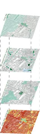
Developing a global perspective on Urban Planning through a master’s studio during study abroad
Pacheco, Brussels, Belgium & Ghent, Belgium
FROM NEGATIVE TO POSITIVE SPACE
Analysis of the built environment and pedestrian pathways in the Pacheco region of Brussels
INSIDE THE BLOCK
Proposal to eliminate blocks from the Brussels area to promote pedestrian walkways and student unity
INSIDE THE BLOCK PERSONAL SPREAD
Personal magnification on a specific site behind the new KU Leuven building, restructuring the inner block to be open to the public through a local gallery East of the site’s block
BRUSSEL’S ECOLOGY
Study on the flora and fauna found in the Brussel center due to urban sprawl and increasing heat index
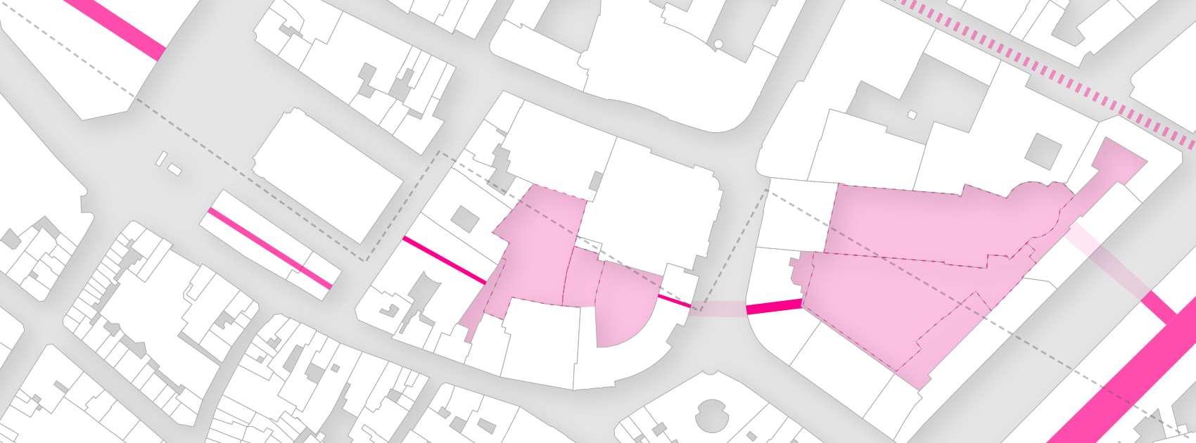
STUDENT AND PEDESTRIAN CONNECTION NEAR PACHECO
This project analyzes the relationship between street space, public space, and private space within the study area of the Pacheco space in Brussels. This map is inspired by a classic Nolli Map to illustrate the different levels of open space and their functions.
Between the streets and hidden spaces
Function areas
Strategic interventions
(Semi-) public open space
Emily Jackson, Floor Loos, Ubbe Vandenameele
Strategic proposals on the micro, meso, and macro scale were proposed in order to connect the buildings, the blocks, and neighborhoods respectively. A larger pedestrian “highway” connects the North and South open spaces like a taproot in the system.
Programs: AutoCAD, QGIS, Illustrator
This project used an industrial UV Printer to emboss the design in white and pink on the contrasting black background.
FROM NEGATIVE TO POSITIVE space


Descriptions:


The final project proposed to transform the scattered camous space in an important way for pedestrian movement. My group tackled topographical changes of the region while creating third spaces for students and residents through east west pedestrian pathing. I worked in AutoCAD and Illustrator to create 3D renderings of building extractions and elevations showing the change in building s and topography.


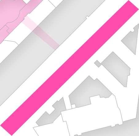
Carving out a space for pedestrians

Project: Personal “Inside the Block” Spread Year: 2023

Programs:
AutoCAD, Illustrator, and SketchUp were used to create the concept designs for the change in built environment for students of Brussels.

INSIDE THE BLOCK
My personal proposal involved restructuring academic buildings of various universities. The project subtracts parts of the buildings to make space for a large stair structure to be used as a courtyard and pathway from the campus to innder pedestrian pathways of the city. There are several different universities that neighbor each other in the Pacheco region of Brussels, so a universal campus space would provide a sense of unity and identity within the students.


possibilities and reference projects
possibilities Channel
Section 2


possibilities brown eld conversion
By focusing on soft banks, biodiversity can redevelop and this can have a strong in uence on the surrounding fauna and ora. Next to this, a lowered and soft bank of the canal can also o er new opportunities to the campus area. By making the water accessible, the canal can become part of the campus for recreation and relaxation
Section 1
Although the area around the Abattoir is still actively and productively used, it is noticeable that many old buildings and vacant lots are also visible in the area. To maintain the character of the environment and increase biodiversity in the area,


possibilities Pocketparks & green streets
The dens neighborhoods around the canal often have narrow and inaccessible roads. If the mobility plan is revised, less used starts could be used


and

and

Brussel’s Ecology
possibilities and reference projects


by


for

Reopening the old arms of the Senne and restoring the river to its original state could help ensure a cooler climate in the city center. The Senne's presence could help reduce the Heat Island e ect, which weighs negatively in the heavily paved area. Opening the river can also be an incentive to green the environment in the neighbourhood


Programs: Adobe Illustrator, QGIS

In order to create natural connections in the center of the city, it is necessary to support private initiatives in order to create coherent connections. Initiatives such as the Swedish BeUrban can be a possible stimulator to promote both rooftop gardens and biodiversity projects that bene t the city and the people.
green streets By reopening the old (said arms) of the zen and restoring it to its original state, this can help ensure a cooler climate in the city center, and this can have a positive e ect on the Heat Island e ect, which weighs heavily in the stong paved area. Opening the river can also be an incentive to green the environment in the neighbourhood possibilities and reference projects
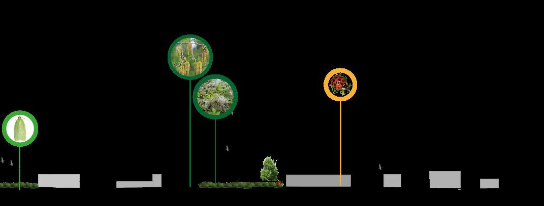
An observational diagram made on the urban flora and fauna of the Brussels region. Including invasive species prevalent from unchecked cross contamination and native species endangered from deforestation.
In order to create natural connections in the center of the city, it is necessary to also support private initiatives in order to create a coherent connections. Initiatives such as the Swedish BeUrban can be a possible stimulator to promote both rooftop gardens and biodiversity projects that benet the city and the people.


The heat map, available greenspaces, and watershed maps help describe the built environment and hospitality for the flora and fauna in the Brussels urban space.


During the construction of the North-South connection, many places were heavily paved and fell into disuse. These scars are still visible today as over-dimensioned / redundant roads,... These forgotten places could be an ideal location in the future to set up softening or greening projects.
During the construction of the Nort-South connection, many places were heavily paved and fell into discuse. These scars are still visible today as over-dimensioned / redundant roads,.. These forgotten places could be an ideal location in the future to set up softening or greening projects.
Through this group project, I created elevations, designed maps through Adobe Illustrator, and learned how to use a new form of GIS called QGIS.


geodata.envirennement.brussels, curieuzenair BXL, geobru, brussels.be Plantes_biodiversit, Science direct, convention on bioloical diversity, erfgoed.brussels,
possibilities Old Senne
Pocketparks &
Queensgate Revival
Queensgate Revival
Year: 2024
Team: Emily, Andrew, Lucas
Programs: Illustrator, SketchUp, GIS, Revit
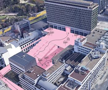
With the installation of a new bridge over the Ohio River, our class envisioned ways to make the connecting area in Cincinnati a more vibrant community. Currently the Queensgate neighborhood does not have many residents and has been reserved for a dying industrial use.
Project Vision: To transform Queensgate from a neglected and divided industrial space into a connected, vibrant high-tech hub that will bring a renaissance to the area. This transformation will help elevate Cincinnati as region leading city for economic growth and job opportunity.
Zone 1: Creating new recreational spots under the highway overpass and revitalizing an unused railway overcome by nature
Zone 2: Revitalizing the area with diverse economic and mixed-use buildings
Zone 3: Focusing on an urban forest to reduce heat island effect form vast highway network


Longsworth Link
Skills and Programs Used: Adobe Photoshop, Illustrator, GIS, AutoCAD, and SketchUp.
Longsworth Link is my own vision to make use of the overpass areas creating walking trails, sports courts, recreation equipment, bike trail, and pedestrian path with a line of small shops like cafes, book sotres, and local businesses.
The trail leads to the Western portion of the project that has mixed use buildings, studios, and an open-air first floor that allows pedes trian pathways to remain unobstructed.
Focuses on the building use, walkability, and greenspace were all considered.


Emily Jackson


C0-OP Graphic Work
3CDC CO-OP Work
OTR Building Typology Map
The map provides an understanding of the building types within North OTR, distinguishing between apartments, condos, single-family homes, and other types of properties
The area is bounded by Liberty St to the south, E McMicken to the east, W McMicken to the north, and Central Parkway to the west.


• Land refers to vacant lots, parking lots, or occasionally alleys or rights-of-way with an address.
• Vacant refers to any building we determined to be currently unoccupied.
• Other include commercial buildings, offices, manufacturing spaces, places of worship, etc.
Year: 2024
Team: Emily, Ismael Programs: ArcGIS Online, Excel, Illustrator
Descriptions:
In order to collect the accurate percentage of building types and number of units in each apartment, my teammate and I handcchecked all apartment numbers and building registrations in the Northern OTR neighborhood. We created a spread in excel and visually for the rest of our department to use in future devleopment projects.


Green Umbrella Graphic Work
Programs: InDesign and Canva Nonprofit graphic work such as announcements and revisualizing benchmark and Gield Guide PDFs in future devleopment projects.


The West side of Cincinnati has long been neglected and tumbled down the path of Environmental Injustice. The Mill Creek, once known as the most polluted water system in America, has made substantial improvements in cleaning the creek water and protecting the environment. But still risk hangs onto this infamous area.
Emily Jackson 2024 by EmilyPlanning - Issuu
This project proposes to create a system to increase greenspace and mitigate floodrisk through a cloudburst system. Study areas were found through GIS and the project honed onto specific suitable areas near the Mill Creek
U se C ases
Learn Pricing
I proposed to restructure the area of English Woods (pictured below) to prioritize nature preservation and education of the public through community centers and pocket parks in the neighboring area.
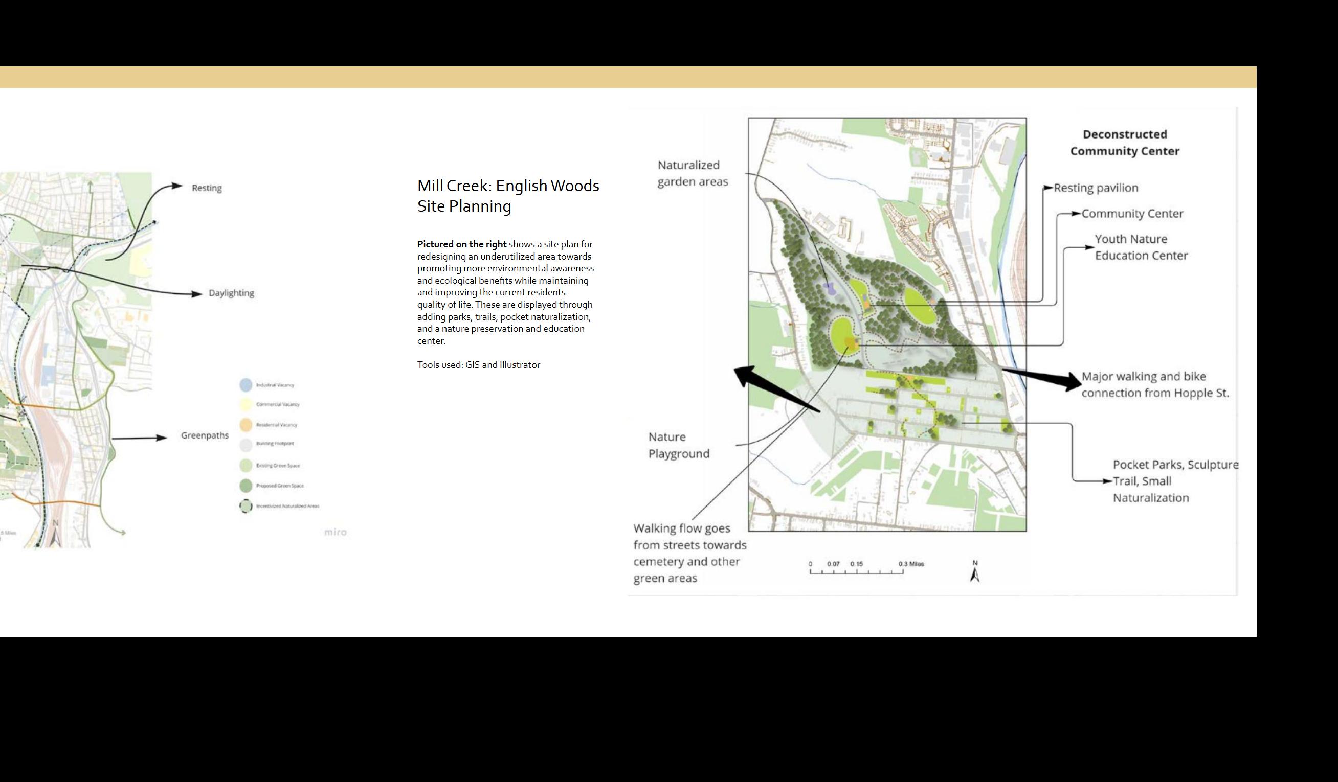
ENGLISH WOODS POCKET PARKS
Year: 2022
Team: Emily, Florence, Arika
Programs: ArcGIS, ArcGIS Online, Adobe Illustrator, MIRO


Built Environment of The University of Cincinnati

Project: Understanding Your Current Environment
Year: 2020


University of Cincinnati Topography
Skills and Programs
Used: Illustrator, ArcGIS, LaserCutting, and Woodworking
Revit Practice for St. Louis Property

MISSOURI NATIVE RAIN GARDEN
Client: Seeker Real Estate
Year: 2024
Skills and Programs: Revit, Illustrator, Hand Drawing, Excel
In 2024, I challenged myself to learn Revit and completed the Beginner Revit Certificate Course on LinkedIn Learning. I worked with a residential developer in St. Louis and modeled one of their properties to propose a garden design best suited for their needs.


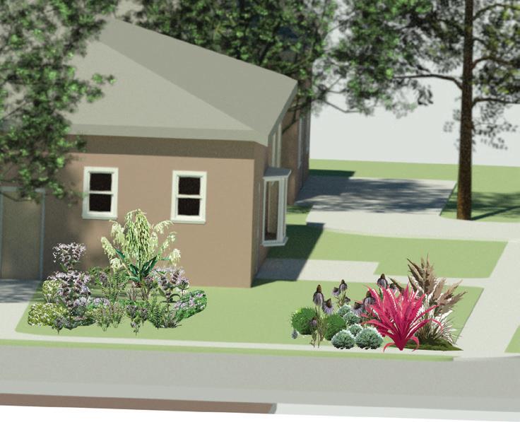

Description:
I researched for several weeks the different soil types of Missouri, native plants, full sun to shade loving plants, and designs of other gardens common in the area. My goal was to make a shade heavy rain garden to mitigate drainage problems from the nighbor’s rain runoff. I designed a smaller full sun garden on the corner to be used for privacy and aesthetics.
I created excel sheets of the native plants and catalogged their information and bloom times to graph an ideal selection for beautiful garden design year round for the client.