ENVIRONMENTAL AND SOCIAL JUSTICE IN HARLEM INTERROGATING ENVIRONMENTAL HISTORIES THROUGH PRESERVATION


Historic Preservation Studio II Spring 2022

Columbia University Graduate School of Architecture, Planning, and Preservation

CONTENTS
ACKNOWLEDGEMENTS 4
FACULTY PREFACE 5 INTRODUCTION AND METHODOLOGY 6
HISTORIC CONTEXTS AND ASSETS 10
Climate Risk and Response 12 Energy 14 Fresh Food and Nutrition Access 16 Hazardous Material Exposure 18 Indoor Air Light and Ventilation 20 Open Spaces and Green Resources 22 Outdoor Air 24 Redevelopment and Displacement 26 Solid Waste Management 28 Transportation 30 Water and Quality Management 32
KEY ISSUES
34
NARRATIVES OF ENVIRONMENTAL JUSTICE ACTIVISM 37
Occupying Space for Gray 37
The Young Lords: Organized Offensives for Justice 38 Green Guerillas 38 WE ACT: Targeting Sites of Pollution 39 Contemporary EJ Activism 40
LACK OF SPATIAL ENCOUNTERS WITH ENVIRONMENTAL JUSTICE HISTORIES
42
Listing and Designation 42 Environmental Justice in Listing and Designation 42 Monuments, Memorialization, and Public Art 44
LANDSCAPE VULNERABILITY 46
Bedrock Differences and Complications 47 Soil Compounds Land-based Vulnerabilities 47 Historic Waterways and Marshlands 48 Land Reclamation and Infill on Harlem Marsh 49 Floodplains and Contemporary Risk 52 East and West Harlem Disparities 53 Modeling what Lies beneath Harlem 54
VULNERABLE POPULATIONS 56
Dispossession of Lenape Peoples 56 Changing Demographics 56 Shifts in Geographic Distribution 58 Harlem’s Income Gap Widens 59
HOUSING INEQUITIES 60
Housing’s Relationship to Environmental Justice 60 Access to Light and Fresh Air Limited by Design 60 Poor Plumbing, Ventilation, and Lighting 62
2
| CONTENTS
Heat Inadequacies 62
Conditions Exacerbated by Slum Clearance & Redlining 63
Redevelopment versus Rehabilitation 64
Lead Paint Vulnerability 66
NYCHA’s Lead Paint Crisis 66
Public Housing Demographics 67 Public Housing Vulnerabilities 67
DISPLACEMENT RISKS 69
Density and Crowding 69
Power and Displacement 70 Displacement Vulnerability 70
Changing Rent Burden Impacts Affordability in Harlem 71
High Proportion of Renters Contributes to Harlem Vulnerability 72 Loss of Businesses 72
REDEVELOPMENT CONFLICTS 74
Cleanliness as a Driving Narrative for Redevelopment 74 Redevelopment and Contaminated Land 76 Burdens Associated with Transportation 78
Energy Transitions 79
Historical Precedents for Community Distrust 81
OPEN SPACE DISPARITIES 82
Public Parks, Playgrounds, and Community Gardens 84
Trees 87
Heat Vulnerability and Cooling 90
HARLEM SKY TENSIONS 92
PROPOSALS 98
Spatializing Environmental Justice Activism In Harlem 100
Visualizing Harlem’s Green History 106
Adding a Historical Layer to the 135th Street Marine Transfer Station 114 Melting: Experiencing Heat In Harlem 118 Expanding Green Space: Living Roofs In Harlem 122
The Harlem Sky: Viewsheds And Energy Open-Scapes 126
Breaking the Cycle: Learning From the Past to Reimagine a New Energy Future 130
Redesigning Pleasant Village Community Garden For Resiliency 136 Creek Corner 142
Public Outdoor Swimming Pools Re-Imagined 147 Energy Retrofits in Historic Public Housing 153
Visualizing Health and Housing Inequities in Harlem: A Mobile Exhibition on Environmental Injustice 158
APPENDICES 162
APPENDIX A: HISTORIC CONTEXTS AND ASSETS 163
APPENDIX B: HISTORIC ASSETS DATA 218
APPENDIX C: CONTEMPORARY ASSETS 236
APPENDIX D: CONNECTOR ORGANIZATION INTERVIEWS 238
APPENDIX E: BIBLIOGRAPHY 241
APPENDIX F: IMAGE SOURCES 253
3
CONTENTS |
ACKNOWLEDGMENTS
This report was produced by Columbia University’s Graduate School of Architecture, Planning, and Preservation (GSAPP). The report compiles the findings of a semester-long Historic Preservation (HP) studio in the spring of 2022 at GSAPP. This is a studio premised on concepts of community-engaged research and learning as integral aspects of preservation practice. Students and faculty alike have benefited from the knowledge and perspective of a number of representatives of the Harlem community and beyond, whom the team would like to thank and acknowledge.
Ascendant Neighborhood Development Corporation
Chris Cirillo, Executive Director
Manhattan Community Board 10
Karen Horry, Chair, Parks and Recreation Committee
Friends of Morningside Park
Brad Taylor, President
Harlem Community Development Corporation
Curtis Archer, President
Harlem Park to Park Nikoa Evans, Executive Director
Marcus Garvey Park Alliance
Suzan Marciona, Vice President
New Yorkers 4 Parks
Adam Ganser, Executive Director
Pleasant Village Community Garden
Lupe Sanchez, Interim Secretary
Nadege Alexis, Member
Save Harlem Now!
Angel Ayon, Vice President
Lynn Hendy, Treasurer
The Shabazz Center
Najha Zigbi-Johnson, Director of Institutional Advancement
Trust for Public Land
Joan Keener, Deputy Director, NYC Playgrounds Program
WE ACT (West Harlem Environmental Action)
Chris Dobens, Director of Communications
Groundwork Hudson Valley
Brigitte Griswold, Executive Director
Candida Rodriguez, Director of Community Relations
Columbia University Climate School, Earth Institute
Dr. Liv Yoon, Addressing the Urban Heat Island through an Equity Lens
The studio team extends its gratitude to Columbia colleagues who lent time and support to the studio, including Thaddeus Pawlowski of the Center for Resilient Cities and Landscapes at GSAPP, Jacqueline Klopp and Paul Gallay of the Center for Sustainable Urban Development at the Climate School, members of the Environmental Justice and Climate Just Cities Earth Network, and the faculty at-large of GSAPP’s Historic Preservation Program. Students and faculty also wish to thank Najha Zigbi-Johnson and the Shabazz Center for graciously providing access to the historic Audubon Ballroom, and Lindsay Papke for sharing her thesis research on East Harlem.
| ACKNOWLEDGEMENTS 4
FACULTY PREFACE
The subject of environmental justice may seem removed from the scope of historic preservation. In conceiving this studio, faculty intentionally sought to explore what connections might exist and how the methods of preservation might inform understanding of how environmental injustices are historically created and persist within the built environment.
People of color, low-income people, and Indigenous peoples are disproportionately affected by harmful environmental conditions. These injustices are historically rooted in racist and exclusionary land use decisions. They are embedded in built environments and institutions, and are often repeated and reinforced in ongoing decision-making about land use, planning, preservation, climate adaptation, and more.
This studio was inspired by the Environmental Justice for All Scope of Work report prepared by the NYC Mayor’s Office of Climate and Environmental Justice (2021), which called out the need to address land use issues that may contribute to new or existing environmental justice concerns. We challenged students to apply a preservation lens to examine how environmental injustice and climate vulnerability have been socially constructed in Harlem over time through policies, practices, and projects that shape landscapes and the built environment, and privilege or disprivilege the publics that inhabit them. Students leveraged preservation methodologies to investigate the social-spatial dynamics and place-based dimensions of communities and their longitudinal manifestations.
Student inquiries focused on the following:
HISTORIES: What stories, places, events, works, policies, organizations and entities, and individuals characterize, represent, and/or demonstrate evidence of environmental justice or environmental racism/injustice?
CONSEQUENCES: How have people and the places they inhabit been affected by these histories over time? How are these histories and their consequences encountered and/or experienced today, if at all?
INTENTION: How can the preservation enterprise through community-engaged research, policy, physical intervention, interpretation, creative expression, etc. instrumentalize the social and spatial evidence of these environmental legacies to promote environmental and climate justice?
Through their research and conceptual proposals, students challenge these histories and their complicity in perpetuating environmental injustice, and also imagine and posit preservation’s role in activating these histories toward more just futures.
Students Kemuning Adiputri Elaf Alsibyani Adam Brodheim Daoxin Chen Emily Conklin Schuyler Daniel Jacqueline Danielyan Kerrian France Michelle Leach Xiyu Li
Winnie Michi Trujillo Nina Nahitchevansky Student Graphic Designer Hongye Wang Teaching Assistants
Anna Gasha
Ziming Wang Faculty
Erica Avrami, PhD
James Marston Fitch Assistant Professor of Historic Preservation Morgan O’Hara
Adjunct Assistant Professor of Historic Preservation
FACULTY PREFACE | 5 ▪ ▪ ▪
Shivani Rajwade Jerry Schmit Yinjie Tian Shannon Trono Mimi Vaughan Hongye Wang Wenjing Xue Clara Yip Damiana Yousef Zihao Zhang Shuya Zhao
INTRODUCTION & METHODOLOGY
INTRODUCTION
This studio inquiry, titled Environmental and Climate Justice in Harlem: Interrogating Environmental Histories through Preservation, focuses on these contemporary health and equity issues through a preservationist’s perspective— prioritizing change over time and spatial histories. As a studio, we spent a semester engaging local community groups while conducting on-the-ground field studies and rigorous research into the environmental story of Harlem.
This report presents key issues that we identified and interrogated through historic research, material engagement, and community outreach: many of the topics explored in the report investigate overlaps, intersections, and parallels we found between previously disparate ideas. In this way, we have brought into conversation bodies of work spanning environmental science, social justice, architectural preservation, and city politics, to name a few.
This breadth of inquiry may seem outside the realm of what is typically understood as “Historic Preservation,” and that in many ways was our goal. We believe that our work as preservationists, and as part of Columbia’s architecture school, is to find and illuminate concepts and practices that affect our built environment. The work of this studio goes beyond architectural aesthetics and into the realm of turbulent spatial histories that make up the historic fabrics in which we live.
First, it is important to ground our research in the definition of environmental justice, or EJ, with which we began the studio. The following is cited from the New York City Environmental Justice for All Report, which was used as a base:
The fair treatment and meaningful involvement of all persons, regardless of race, color, national origin or income, with respect to the development, implementation and enforcement of environmental laws, regulations, policies and activities and with respect to the distribution of environmental benefits.
Fair treatment means that no group of people, including a racial, ethnic or socioeconomic group, should (i) bear a disproportionate share of the negative environmental consequences resulting from industrial, municipal and commercial operations or the execution of federal, state or local programs and policies or (ii) receive an inequitably low share of environmental benefits.
(NYC Mayor’s Office of Climate and Environmental Justice 2021, 6)
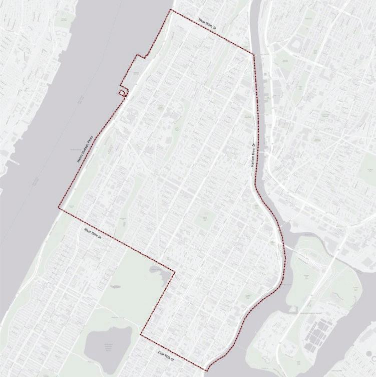
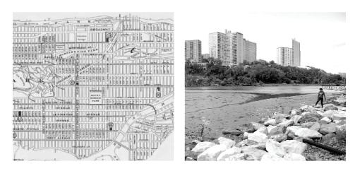
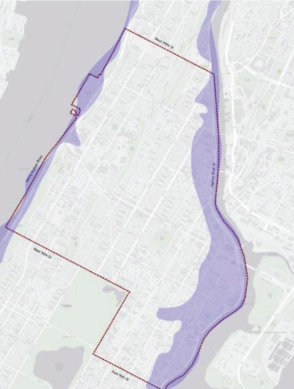
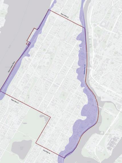
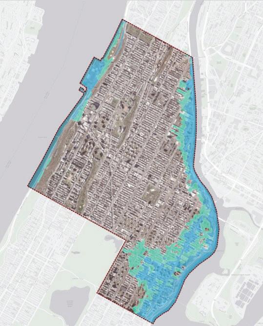
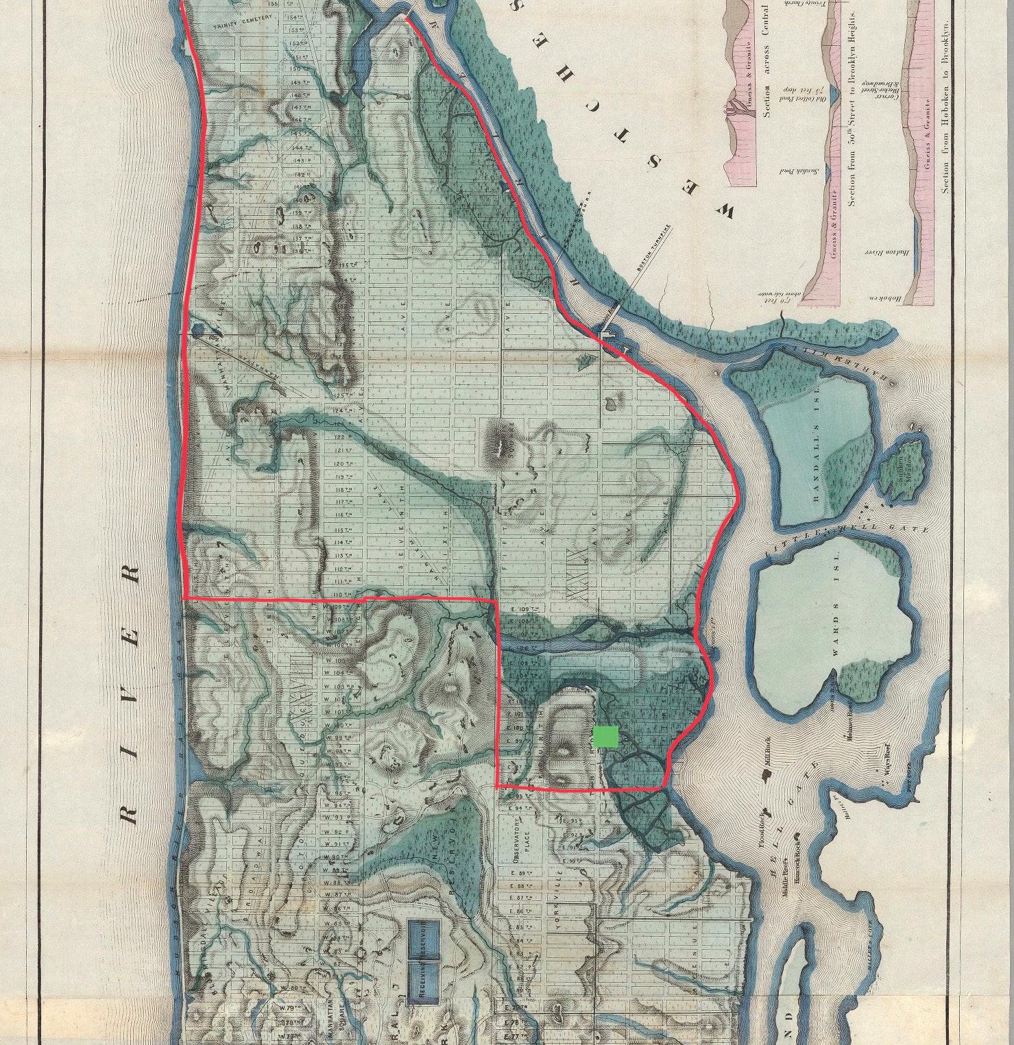
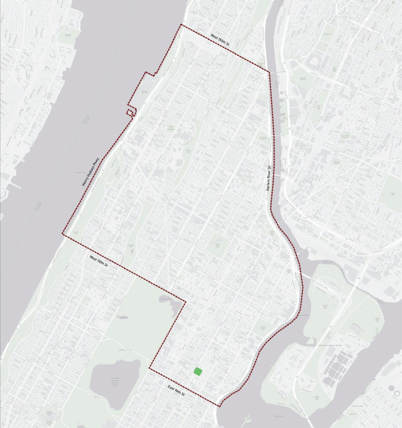
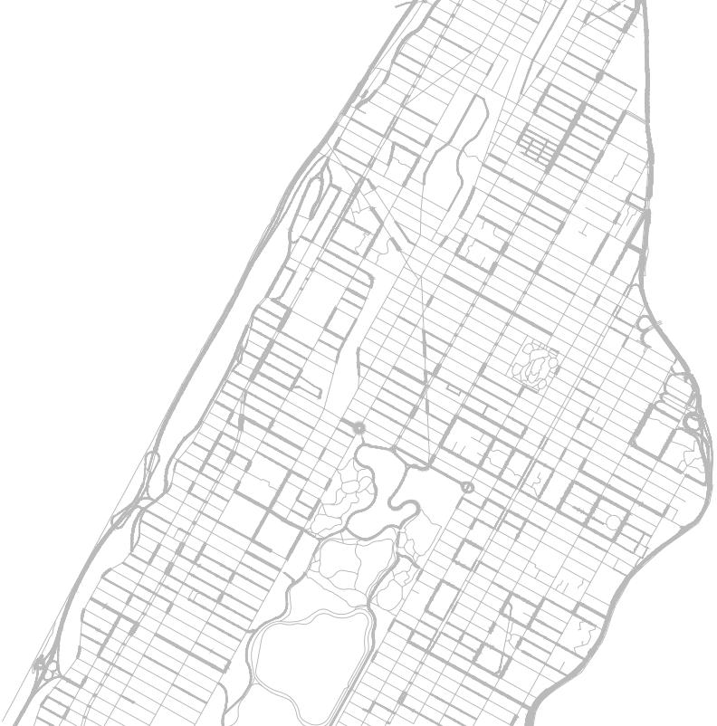
With this definition in mind, we then defined our geographic area of study for inquiries further into the spatialization of this environmental justice issue. Our area is defined roughly as “Harlem,” bounded by the Hudson and Harlem Rivers stretching from 155th Street down to West 110th and East 96th Streets to the east of Central Park. We did not investigate this large area of Upper Manhattan homogeneously, however. We recognize that there are significant differences in land form, culture, and population histories in smaller neighborhood pockets like Hamilton Heights, Morningside Heights, and El Barrio, just to name a few.
Studio II study area.
7
INTRODUCTION & METHODOLOGY |
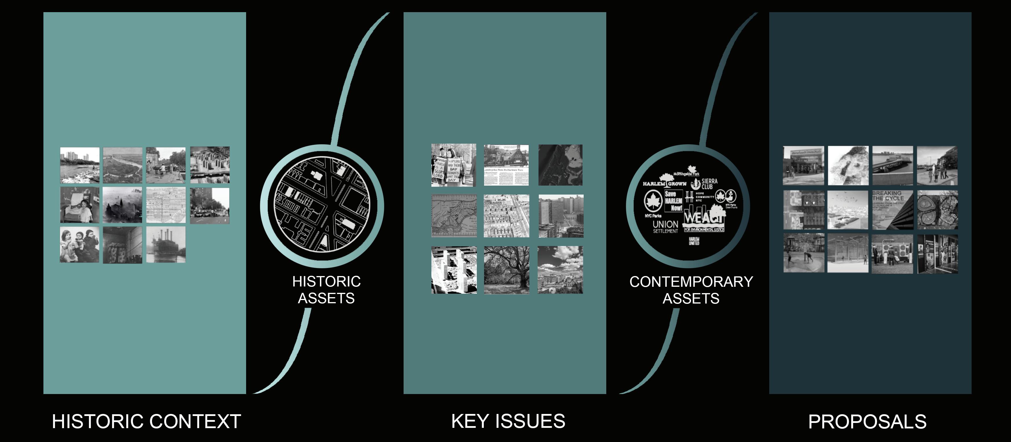
The methodology of Studio II consists of five steps: historic context, historic assets, key issues, contemporary assets, and proposals.
METHODOLOGY
Our research process constructs the core of our studio methodology. Each step of the process will be explained in detail, but includes historic context research, key issues focusing on analysis of change over time, and proposals that respond to the wide base of work previously conducted. The studio identified historic assets to spatially orient our historic research and contemporary assets to connect with actors in the community.
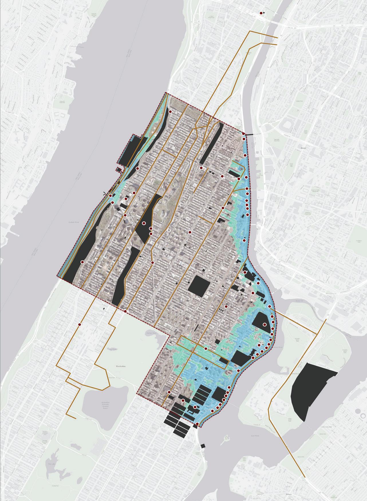
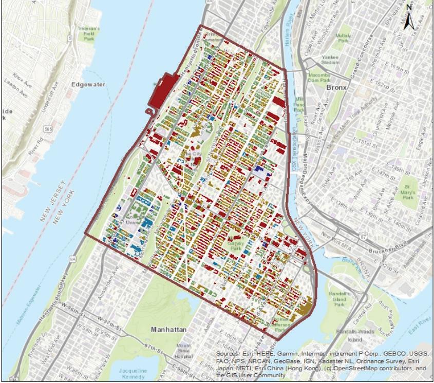
We began this studio in January 2022 by exploring historic context. Eleven themes were identified by the faculty as pertaining to environmental justice. They deal with a wide range of social, spatial, and political realities that have been historically tied to fights for environmental justice, and remain at the forefront of activist efforts today. These research-based explorations, which revolved around a specific spatial identity and the populations that interacted within Harlem, helped us to better understand the issue of environmental justice in our study area. Working within these themes, we undertook Historic Context analyses, which summarized our research findings as well as a selection of Historic Assets.
By embarking on a field survey in February, we identified historic assets within the study area these “assets” ranged from individual objects or building footprints to entire urban corridors that contain significance and histories related to climate and environmental justice issues, whether surviving or not. These place-based heritages within the community gave us a better understanding of the multidimensional history of environmental justice in Harlem.
Through exploring historic context and assets, nine major key issues were identified that significantly affected the histories and consequences of environmental justice in Harlem. We delved deeply into examination of the data compiled to date, and generated additional information and insights through a field survey, mapping, narrative and demographic analysis, formal analysis, data visualization, and community-engaged research. With these key findings, we sought to establish a firm basis to inform future action.
8
| INTRODUCTION & METHODOLOGY
In tandem with the spatial assets identified through our historic context research, we also identified community connectors as contemporary assets. By interviewing representatives of organizations that share common values with our studio inquiry, we learned about intersecting concerns, observations, and added insights for our study. These informed our analysis of key issues and guided proposal development.
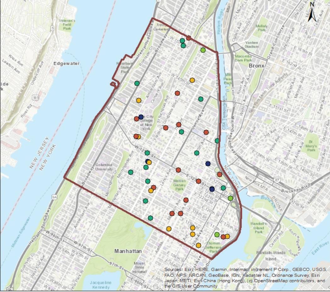
The historic assets map includes 61 point assets, 18 polyline assets, and 122 polygon assets.
Students and faculty discussed key takeaways from interviews with representatives of organizations.
To implement our evidence-based findings in the final part of the methodology, our ultimate goal in this studio was to put forth proposals that promote environmental and climate justice in Harlem, and alert stakeholders, residents, and governmental bodies to past injustices. Each of the proposals that make up the final section of this report has a clear objective, and delves into complex and multi-faceted key issues. By raising our proposal ideas such as architectural intervention, artistic installation, interpretation, and further research recommendations we as future preservationists hope to use our own strengths to address the social, cultural, and environmental issues that affect our built world.
9
INTRODUCTION & METHODOLOGY |
HISTORIC CONTEXTS & ASSETS
HISTORIC CONTEXTS AND ASSETS
The starting point of this studio was the examination of the historic contexts that contributed to the conditions experienced in Harlem today. Eleven overarching themes were identified by the faculty, each dealing with a wide range of social, spatial, and political realities that have been historically tied to fights for environmental justice, and remain at the forefront of activist efforts today. These research-based explorations revolved around specific spatial identities and the populations that interacted within Harlem, and were foundational in better understanding issues of environmental justice within the study area and as it relates to the city as a whole.
In relation to each of these themes, students also identified historic assets: places and spaces associated with the theme’s stories and narratives. This process of identifying, mapping, and ground-truthing assets through a field survey allowed students to further understand how these narratives are spatialized and encountered in the Harlem landscape. Whether assets survive or not also speaks to how certain narratives and the publics vested in them are advantaged or disadvantaged through decision-making about the built environment.
The following themes are summarized in this section, and examples are provided of associated assets. Full analyses of these historic contexts are included in Appendix A, and the complete list of historic assets is included in Appendix B.
> Climate Risk and Response > Energy > Fresh Food and Nutrition Access > Hazardous Material Exposure > Indoor Air Light and Ventilation > Open Spaces and Green Resources > Outdoor Air > Redevelopment and Displacement > Solid Waste Management > Transportation > Water Quality & Management HISTORIC CONTEXTS AND ASSETS | 11
CLIMATE RISK AND RESPONSE
ASSETS CONTEXT
Endemic flooding, heat island effects and heat-related health issues, as well as extreme temperature fluctuation are areas of climate concern that have been and will continue to be exacerbated by the ongoing effects of climate change, and the costs will directly affect various vulnerable communities living and working in Harlem. Extant historic assets for this theme include public access-based solutions like shade and cooling facilities, acute vulnerability sites, and historical interventions to the existing landscape. Key historic assets analyzed also included historic waterways throughout the neighborhood, topographic outliers, glacial remains, and historic landscape typologies.
Harlem’s topography and underlying natural formations are greatly influenced by geologic histories stemming from the island’s formation by the Wisconsin Glacier during the last ice age. The extreme differences in elevation between east and west boundaries of Manhattan, as well as an extensive floodplain on the eastern shoreline, are the root causes of many of these instances of climate injustice and uneven mitigation efforts over time. Conditions are exacerbated by ongoing negligence toward resilience efforts to protect populations from the negative effects of the environment and the underlying, systemic forces that have resulted in community vulnerability then and now.
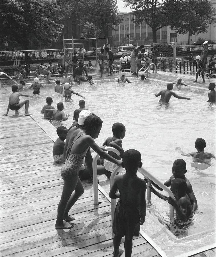
Due to multiple factors, Harlem has been documented to have high vulnerability to extreme heat conditions and is one of the warmest neighborhoods in New York City (Vant-Hull et al. 2014; Rosenzweig et al. 2006). The area did not have a public pool until 1936, when Colonial Park (now Jackie Robinson Park) was developed. This facility was built thirty years after the West 60th Street pool, the oldest pool documented in Manhattan, illustrating how cooling facilities came to Harlem late compared to other areas of the island.
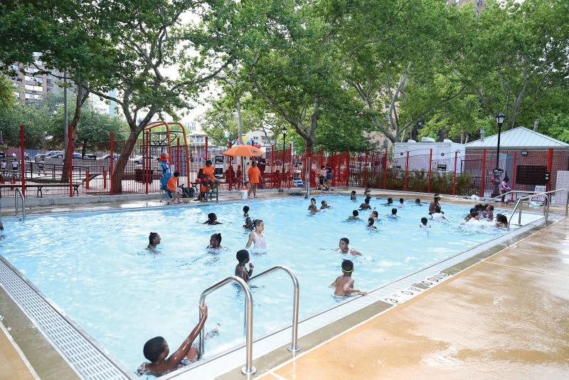
A few additional public pools were added to Harlem, including Jefferson Pool, built in 1936; Abe Lincoln Pool, built in 1951; Marcus Garvey Pool, built in 1967; Wagner Pool, built in 1969; and Sheltering Arms Pool, built in 1970. All of them provide a necessary cooling spot for public use, which Harlem lacked in the past.
Abe Lincoln Pool serves as a cooling facility to mitigate heat in the neighborhood. Photo c. 2005.
12
| HISTORIC CONTEXTS AND ASSETS 12
Abe Lincoln Pool
Before the permanent pool in Marcus Garvey Park was built in 1971, a portable pool would be temporarily set up on what is now the chess table area near Madison Avenue and 122nd Street. Photo c. 1968.
The New York City Housing Authority leased this property to the City in 1969 to develop a public pool for the community. The Wagner Houses Pool serves not only as a memorial to a dedicated political leader but also as a refreshing place for rest and recreation in the community.
c. 2019.
13
Jackie Robinson Pool is in the southernmost section of Jackie Robinson Park. It is one of the eleven pools that commissioner Robert Moses proposed in 1936. Photo c. 2007.
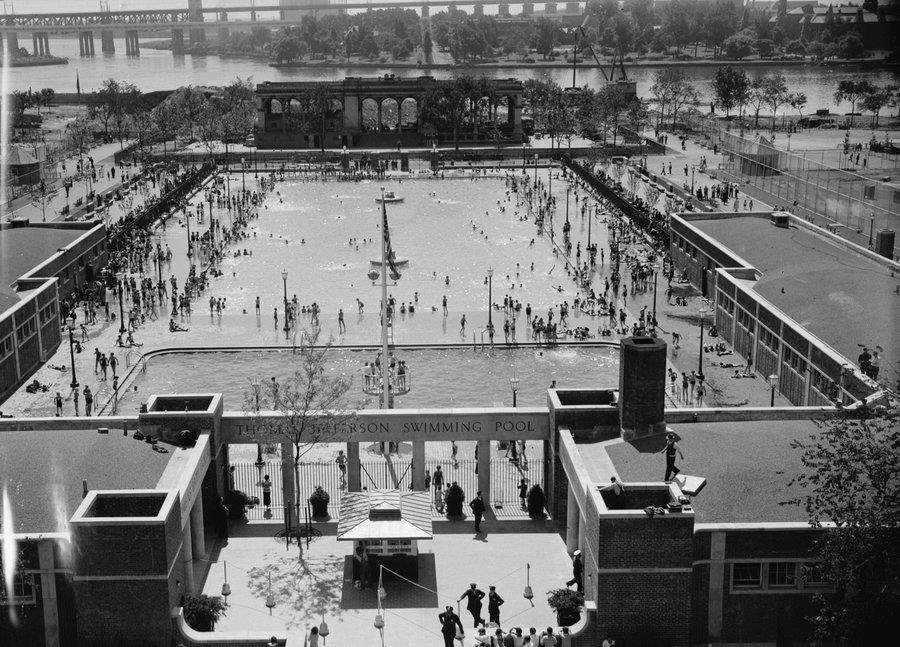
The opening of East Harlem’s Thomas Jefferson Pool, c. 1936.
Photo
Jackie Robinson Pool
Thomas Jefferson Pool
Marcus Garvey Pool
HISTORIC ASSETS - CLIMATE RISK AND RESPONSE |
Wagner Houses Pool
Students identified nine topics as key issues that have significantly informed how environmental injustice and climate vulnerability have been socially constructed in Harlem, through policies, practices, and projects that shape the built environment. Student inquiries leveraged narrative and demographic analysis, formal analysis, data visualization, and community-engaged research to investigate the social-spatial dynamics and place-based dimensions of how these land use decisions have privileged or disprivileged Harlem communities over time.
Through the following nine key issues, students have established the foundation that informs the forthcoming proposals, which imagine and posit preservation’s role in activating these histories.
> Narratives of Environmental Justice Activism > Lack of Spatial Encounters with Environmental Justice Histories > Landscape Vulnerability > Vulnerable Populations > Housing Inequities > Displacement Risks > Redevelopment Conflicts > Open Space Disparities > Harlem Sky Tensions
ISSUES KEY ISSUES | 35
KEY
LANDSCAPE VULNERABILITY
While memorialization represents a more tangible reminder of environmental justice histories in Harlem today, land-based vulnerability poses a less visible way in which environmental justice concerns persist in Harlem. Inquiries of land conditions were developed to understand the underlying forms and systems inherent to upper Manhattan that have contributed to landscape vulnerability
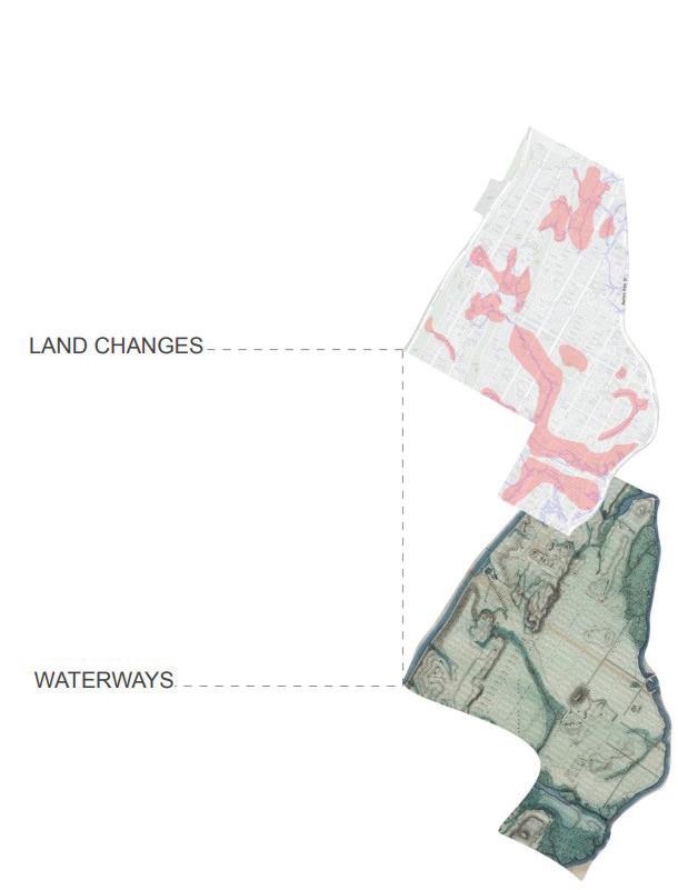
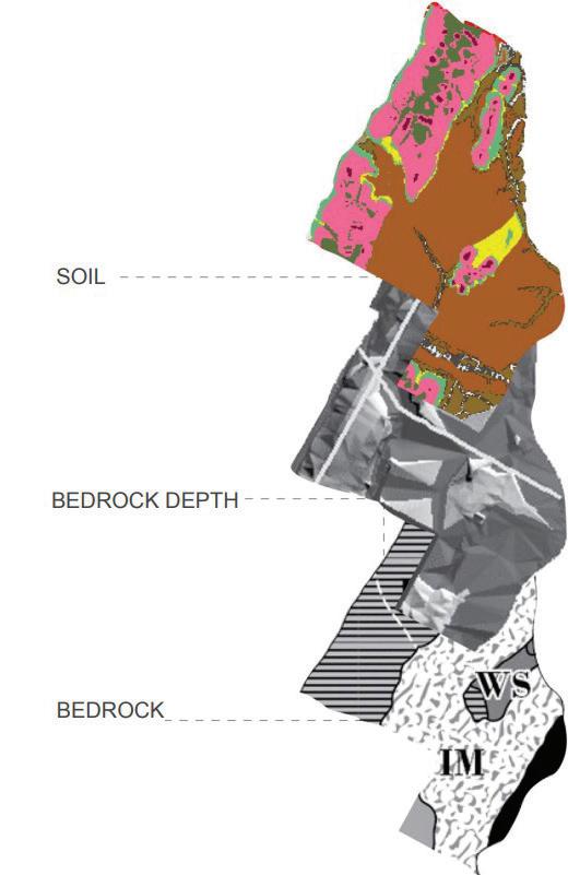
and greatly impacted how people have lived and constructed in Harlem over time. It is important to note that many characteristics of Harlem’s landmass have been modified by human intervention through development and other land use decisions. To set up subsequent inquiries, bedrock and its depth, soil, natural waterways, and manmade land were examined to better understand the foundational layers beneath Harlem as it is known today.
The research focused on the primary formational layers, composed of soil and bedrock, which serve as the foundation for all land and development. This analysis revealed that these layers compiled atop each other constitute a relatively weak foundational base for East Harlem—disproportionately more than West Harlem and the rest of Manhattan Island.
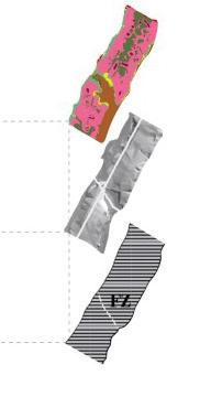
A layered axonometric diagram of each foundational layer of Harlem depicts the site as a whole with various vulnerabilities mapped.
46
| KEY ISSUES - LANDSCAPE VULNERABILITY
BEDROCK DIFFERENCES AND COMPLICATIONS
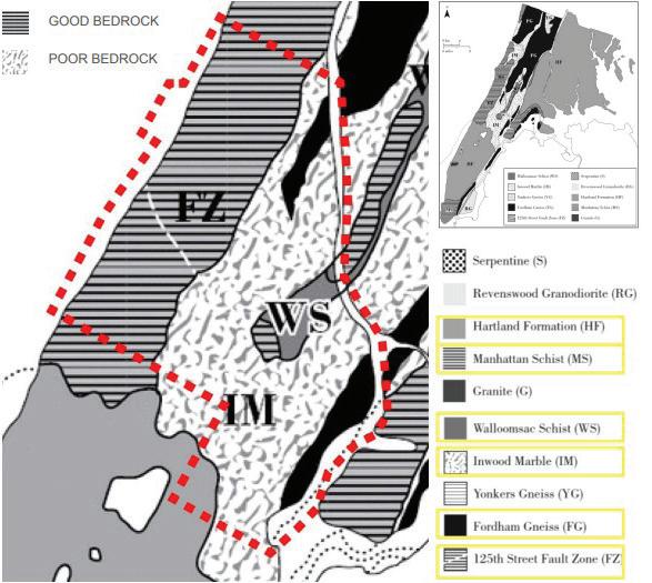
Harlem as a whole is composed of Inwood marble and two types of schist (Manhattan and Walloomsac), with small pockets of Fordham Gneiss found in the north-east (Sanderson 2009). On Manhattan Island at large, the weathering character of each of the metamorphic rock units listed above influences the local topography (Stoffer [1998] 2019). Beneath the densely urbanized Harlem lowlands lies Inwood marble. Inwood marble is both softer and more soluble than the other rock units, and therefore wears down more readily, so that over geological time scales, it has fallen further below top soils and closer to sea level over time (Stoffer [1998] 2019). The majority of the rest of Manhattan is built on Manhattan schist or Manhattan Formation, both of which are exceptionally hard, and are able to support weight more consistently and over longer periods of time (Merguerian and Moss 2006).
Continuing westward from East Harlem is the escarpment rising towards Morningside and Washington Heights. Composed of massive exposures of schist, these locations reveal the complex, faulted, and contorted structures of the bedrock below (Brock and Brock 2001). Not only is the rock type of bedrock poorer quality in Harlem compared to Manhattan at large, but the depth of bedrock dictates vulnerability as well.
SOIL COMPOUNDS LAND-BASED VULNERABILITIES
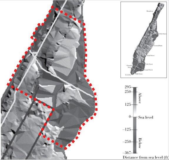
Due to the topography of the island, as subsoil formed, it slid down from the higher hills of West Harlem into the lowlands of East Harlem, burying the bedrock below the soil. Where bedrock is far below the surface and difficult to reach, such as the Inwood marble below Harlem, the need for deeper, more costly foundation types creates inherent problems with possible development and construction in Harlem. To give an example of this, at 90th Street and Central Park West—just below our study area but of the same geological makeup as East Harlem—a developer in the 1940s attempted to reach bedrock to construct a large apartment building. When laying the foundations, the crew was surprised to discover that the bedrock was 60 feet below grade, requiring them to change their foundation plans to reach to the depths of bedrock below (Barr 2016).
47
Map illustrating the rock type of bedrock in Harlem and Manhattan at large.
KEY ISSUES - LANDSCAPE VULNERABILITY |
Mapped bedrock depth of study area in cmparison to Manhattan at large.
Atop the foundation stones of Harlem lies soil. The soil type that lies under East Harlem compounds the issue of vulnerability by being inherently prone to erosion and slow to absorb. But what is bad soil? To the engineer, the subsoil indicates the type of structures that can be supported and what foundations are necessary for stability. Are shallow foundations enough for a building, or does it need to be attached to the bedrock? How does this subsoil affect the construction of infrastructure, such as subways, streets, and other projects?
sea level, well above water, these soils are well drained, and when they do come in contact with large amounts of water, shed the water down hills and into surrounding areas (National Cooperative Soil Survey 2016).
The Ipswich and Deerfield series are less common, but present in East Harlem. The Ipswich series consists of very deep, very poorly draining soils, formed in thick organic deposits. They are found near tidal marshes, which in Manhattan are subject to inundation by salt water (National Cooperative Soil Survey 2018b).
The Deerfield series consists of very deep, moderately well drained soils formed in glaciofluvial deposits, which are sediments consisting of boulders, gravel, sand, silt, and clay from ice sheets or glaciers (National Cooperative Soil Survey 2018b).
When these largely wetter, less permeable soil conditions are considered alongside Harlem’s low-lying geography and deep bedrock, these conditions compound to create problematic conditions during storm surges and large rainfalls. When the area is overwhelmed with water, the soil that Harlem is built atop cannot efficiently drain itself, resulting in land-based vulnerabilities like flooding, poor grounding for infrastructure, and other developmental factors that East Harlem experiences today.
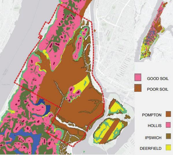
HISTORIC WATERWAYS AND MARSHLANDS
Pompton soils—indicated in brown on the soil map above, and the majority type— are characterized by their moderately coarse texture and poor drainage (Borough of Hawthorne Environmental Commission 2022). They are derived from glacial outwash and exhibit moderate permeability, but due to high water tables and low slopes, they are usually wet (National Cooperative Soil Survey 2013).
The Hollis series, by comparison, which are indicated in pink and predominantly found along the westernmost portion of the site, are shallow to bedrock and are found on ridge crests and areas adjacent to rock outcrops. Far from the average
G
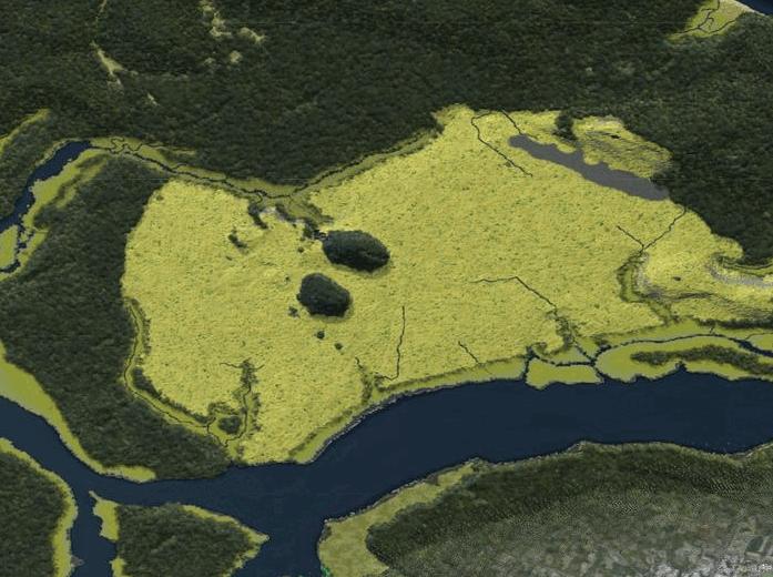
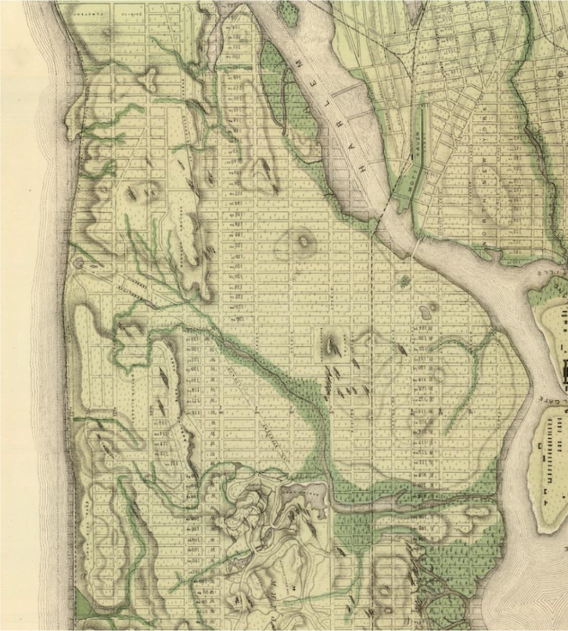
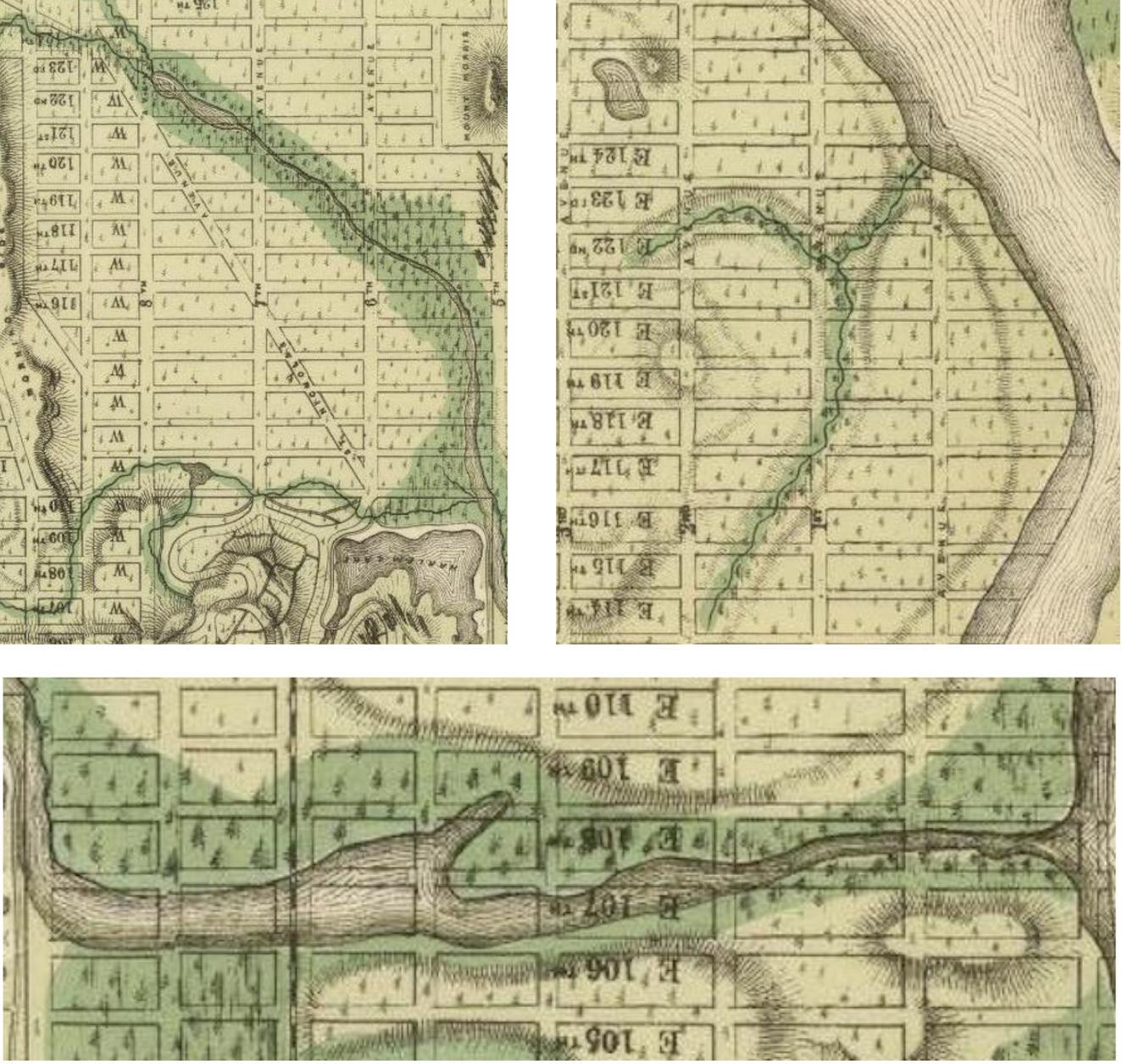
iven the elementally erosive character of Harlem soil, the natural waterways and aquatic systems that impact these soil conditions were investigated next. Looking back at pre-development, pre-grid maps and topographic studies of Manhattan, it is clear that Harlem formerly contained a complex and interconnected system of waterways.
Streams carried water from the heights in the west, creating pockets of rivers and streams. These eventually conjoined at lowland points in East Harlem to create marshland. These marshy areas served as water filtration points, and also absorbed overflow from heavy rain and storm activity naturally. Today, these lowland areas persist, despite being drained, paved over, and geologically forgotten.
The low, marshy areas remain vulnerable as areas where water naturally collects. Today, they are recognized by the socio-political phenomenon of the “floodplain,” or areas that incur high risk of flood action for inhabitants. East Harlem was
48
| KEY ISSUES - LANDSCAPE VULNERABILITY
Map illustrating the variety of soil type in Harlem and Manhattan at large.
Manhattan’s largest active marshland before development spread northwards, taming the ebb and flow of the East River through a system of filtering streams. Now, with East Harlem being one of Upper Manhattan’s most densely packed neighborhoods, the unpredictable nature of the lowland topography poses a threat to residents and the built environment. FEMA’s updated floodplain map shows the potential impacts of 100- and 500-year flood events pumping water as far inland as Madison Avenue, where the Harlem marsh originated.
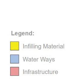
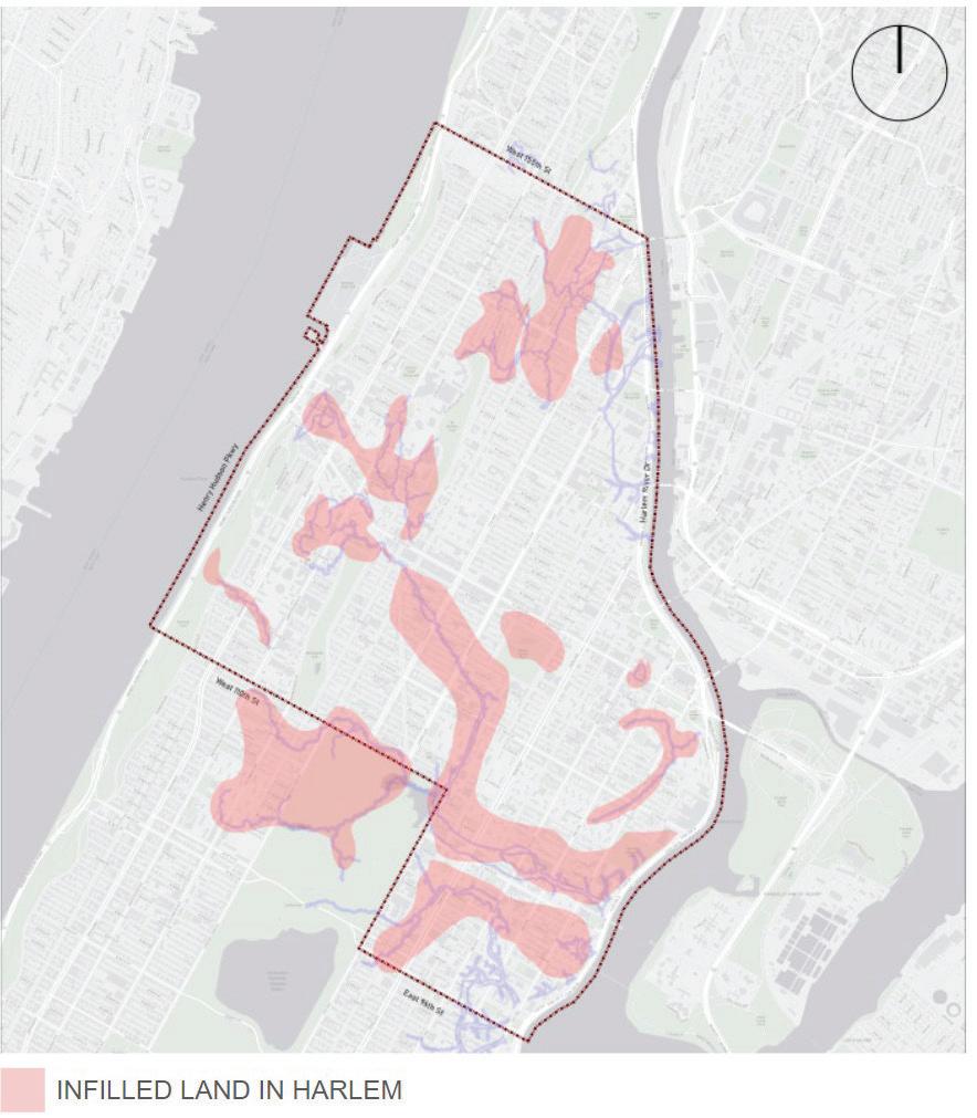
LAND RECLAMATION AND INFILL ON HARLEM MARSH
Even though the marshland areas of East Harlem were unstable, unpredictable, and unsuitable for construction and development in their natural forms, nineteenth-century developers and policy-makers in New York City sought to
overcome this natural barrier. They wanted to make East Harlem just as prosperous as the stronger landmass to the west and south. They chose to embark upon a campaign that drastically changed the natural qualities of the Harlem Flats, infilling the streams and marshes as well as extending land development further into the East River.
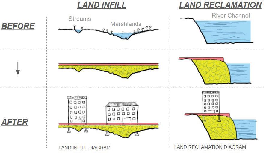
They tackled this feat through two methods: land infill and reclamation. Land infill was implemented along the smaller water bodies and streams that ran through East Harlem to make unusable land usable by filling it with foundation material to level the ground. Land reclamation was also employed to extend the landmass of Harlem by filling shorelines with ground material.
Difference between land infill and land reclamation.
49
KEY ISSUES - LANDSCAPE VULNERABILITY |
Map of land infill and land.
The red area on the left map shows infill along water systems and marshlands, while the yellow areas on the map on the right indicate newly reclaimed land along the Hudson and Harlem Rivers that did not exist before.

Visualization of land reclamation, c. 1609.
This visualization shows the shoreline near the Harlem River before and after land reclamation. The comparison shows how government projects attempted to stabilize the land of East Harlem. Yet their efforts only exacerbated vulnerability in the landscape, leading to land-based inequities that persist in these lowland areas today.
50
| KEY ISSUES - LANDSCAPE VULNERABILITY
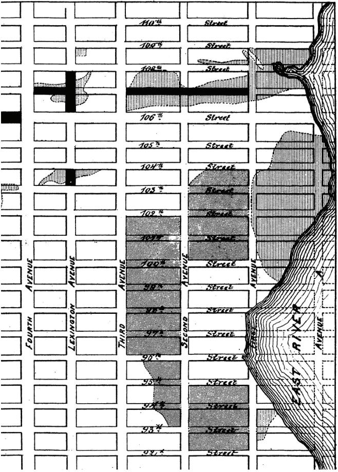
Substandard infill materials.
The efforts of land “stabilization” were carried out through the use of unsuitable materials that did not comply with the New York City code. Repeatedly, surveyors, reformers, journalists, and citizens called for the use of “clean fill,” as in this newspaper article from 1875. In the same year, however, papers followed up with another story, observing that the contractors, as well as private parties, were careless in selecting proper material.
Map of reclaimed land in Harlem.

51
KEY ISSUES - LANDSCAPE VULNERABILITY |
Hurricane Donna (1960) storm surge.
Hurricane Sandy (2012) storm surge.
Floodplain map from FEMA.
FLOODPLAINS AND CONTEMPORARY RISK
These first two maps show two historic storms that devastated Harlem with storm surge and flooding: Hurricane Donna in 1960 to the left, and Hurricane Sandy in 2012 to the right. These storms had surges of 11 and 14 feet, respectively, and surge waters covered many vulnerable coastal lands that are home to public housing, aging infrastructure, parks, and social amenities.
The predictions into the twenty-first century, likewise, are not rosy: looking at the FEMA map, East Harlem’s vulnerable marshland floodplain is poised to continue to flood, the impacts worsening, into this projection for 2050 without coastal resilience intervention or building adaptation. Climate change has and will continue to exacerbate existing vulnerabilities that have been presented thus far; the compounded issues of poor infill on vulnerable lowland, inadequate adaptation, and unstable foundational ground coalesce to form this FEMA floodplain. The increased risk of surges as far inland as Madison Avenue is a significant environmental justice threat.
52
| KEY ISSUES - LANDSCAPE VULNERABILITY
GOOD SOIL
HIGH ABOVE SEA LEVEL
STRONG BEDROCK
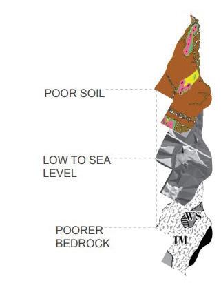
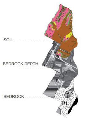
SOIL BEDROCK DEPTH BEDROCK
POOR SOIL
LOW TO SEA LEVEL POORER BEDROCK
An exploded axonometric view of a comparison of Foundational Layers of East and West Harlem.
EAST AND WEST HARLEM DISPARITIES
Land-based vulnerabilities raise a few provocations—the layered maps visually compile all facets discussed that compound East Harlem’s land-based vulnerability.
Shown on the left of the image are the rock formation layers beneath the neighborhood of West Harlem. Supported by Manhattan schist, the soil is composed in a thinner layer, resting atop the bedrock, while the soil itself, being mainly of the Hollis series, performs better with respect to water permeability, erosion, and strength. Illustrated to the right are the layered inequities of East Harlem. Geologically poorer and harder to reach, lies Inwood marble, with inherently poorer abilities to deal with water—both from the sea level and storm surges.
53
WEST EAST HARLEM AS A WHOLE KEY ISSUES - LANDSCAPE VULNERABILITY |
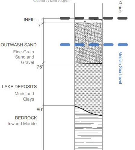
MODELING WHAT LIES BENEATH HARLEM

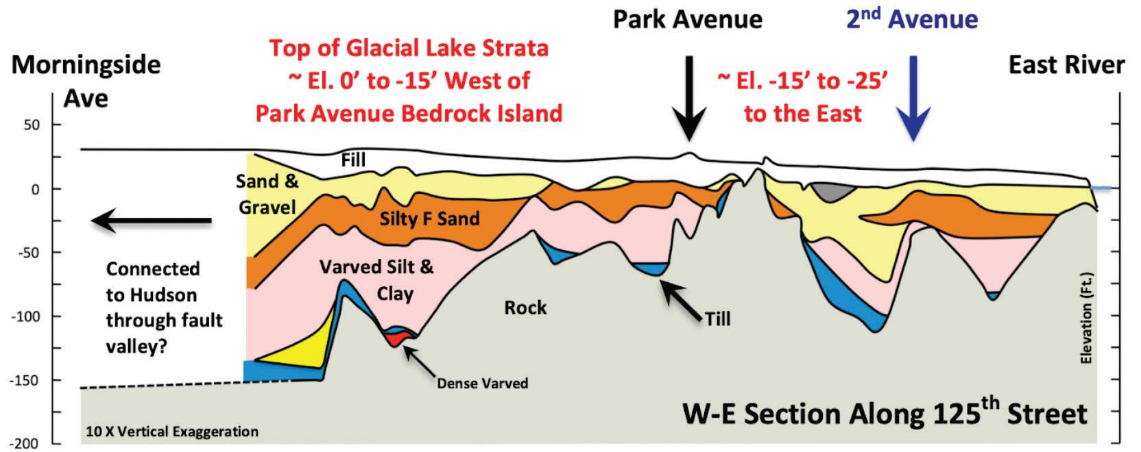
In addition to the aforementioned layers, modeled here are extrapolated earth cores based on our findings. Illustrated through the image of a soil core are the vast differences between the formation of foundations of different neighborhoods. Illuminated is the difference in land quality throughout the study area. Imagining we could physically drill and take core samples from the top soil to the bedrock at various points in West, Central, and East Harlem the findings are not equal.
To focus on the inequities present in East Harlem’s vulnerable landmass, three key findings are illustrated in the upper drawing on the figure to the right, taken on Second Avenue at 140th Street: the median sea level, depicted in blue, hits the finegrained sand of the lowland marsh’s historical typology. This means that building foundations laid into this land hit deep, spongy, erosion-prone materials, and will continue to do so as sea levels rise. By comparison, the lower core drawing taken on Broadway at 128th Street shows the median sea level farther down the core, hitting the solid schist bedrock. The soils atop this bedrock drain better and flooding does not immediately affect these constructions, creating stabler and surer ground for building construction, with less expensive building foundations required.
While these disparities suggest inequities, it is important to keep in mind the difference between causation and correlation. The compounded vulnerabilities shown through landmass are not the only factors inr Harlem’s rate of development, investment, and infrastructure just because there are no skyscrapers where the bedrock is deepest does not mean that deep bedrock was the reason. Just because there were dense immigrant enclaves where the ground is damp and poorly drained, does not mean that wet ground made them slums. Government intervention, knowledge and ignorance of material and land, along with a plethora of other decisions made Harlem as it is today. In order to separate cause and effect, we must also view how socio-economic development occurred in relationship to the environment (Barr 2016).
Image of a soil core illustrating the compounded land-based vulnerabilities found in East Harlem, through median sea level, bedrock depth and rock type, soil, and material.
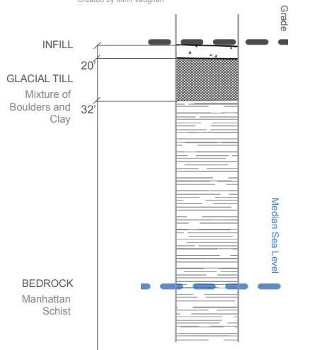
Image of a soil core illustrating the compounded landbased advantages found in West Harlem, through median sea level, bedrock depth and rock type, soil and material.
54
| KEY ISSUES - LANDSCAPE VULNERABILITY
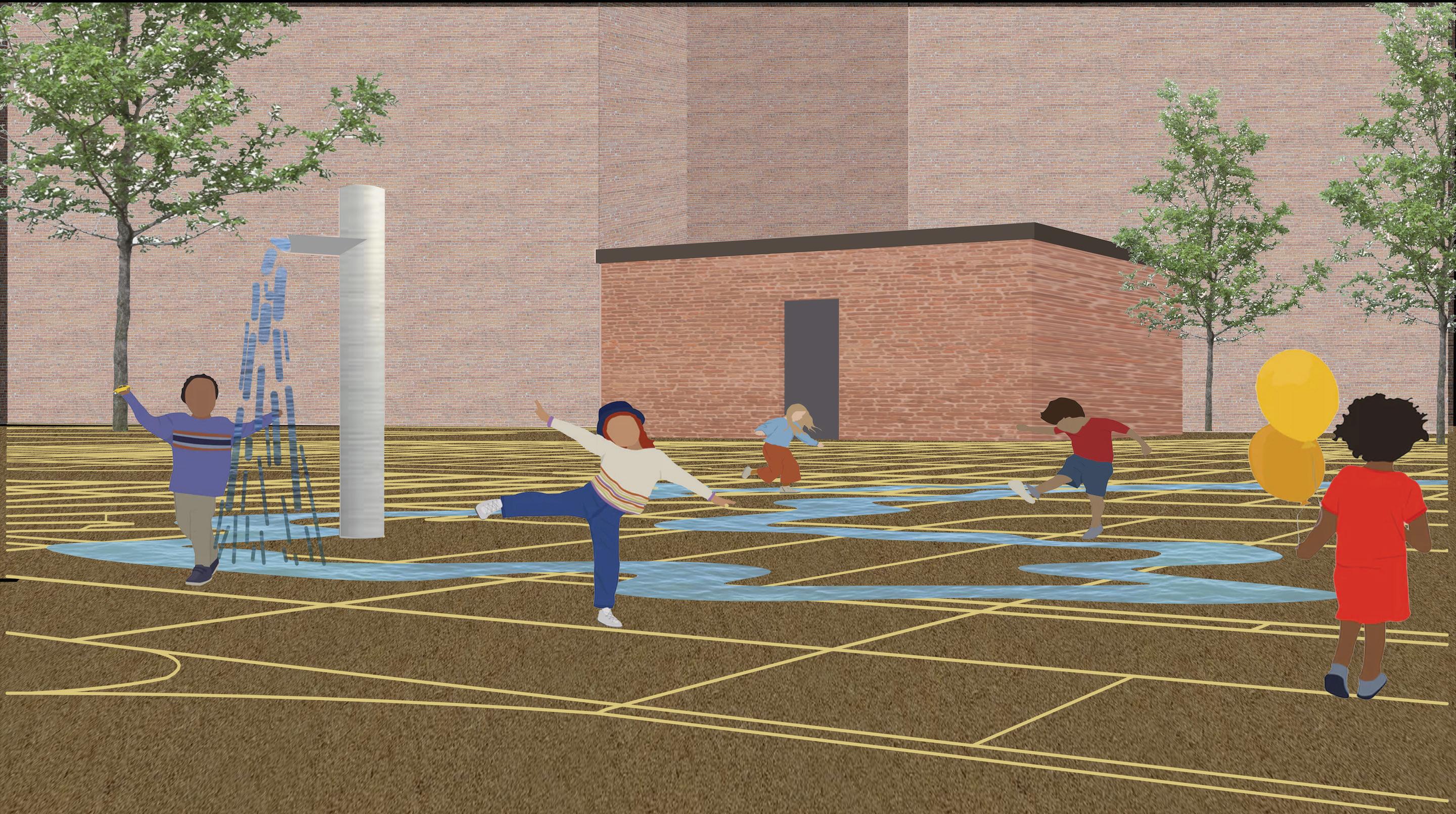
CREEK CORNER
Throughout our studies of the history of environmental justice in Harlem, we began to understand the correlation between the lack of physical space held by environmental justice histories, the inherent vulnerability of the landscape (both natural and man-made), and the inequity of distributed green space. For the three of us, these issues collided and crystallized around the central importance of East Harlem’s past as a marshland with Harlem Creek running through it. We sought a space in this critical location where we could physically ground this history of Harlem. Our proposal is to do this by bringing a brand new interactive children’s sprinkler to the playground in Cherry Tree Park, a playground sited on what was once Harlem’s marshland on Third Avenue and East 99th Street. This new water feature would consist not only of a new and improved spray head, but would create a flow of water that gushes through a model of the historic waterways of Harlem. Further, the project would combine Harlem’s past with its present by overlaying New York City’s street grid on top of the waterways model. We call this “Creek Corner,” as it would inhabit a previously underutilized corner of Cherry Tree Park. It would enable community engagement with Harlem’s histories and “daylight” areas in Harlem that once were marshland or riverbeds.
142
KEY
> NARRATIVES OF ENVIRONMENTAL JUSTICE ACTIVISM > LACK OF SPATIAL ENCOUNTERS WITH ENVIRONMENTAL JUSTICE HISTORIES > LANSCAPE VULNERABILITY > VULNERABLE POPULATIONS > HOUSING INEQUITIES > DISPLACEMENT RISKS > REDEVELOPMENT CONFLICTS > OPEN SPACE DISPARITIES > HARLEM SKY TENSIONS
Adam Brodheim, Mimi Vaughan, and Emily Conklin
ISSUES ADDRESSED
Cherry Tree Park (site of Creek Corner) is located at the green square on this 1865 map of Manhattan.
| PROPOSALS
Cherry Tree Park (site of Creek Corner) is located at the green square.
SIGNIFICANCE AND RATIONALE
Harlem currently has minimal opportunities for interaction with histories of environmental justice. As noted earlier in this report, only three statements of significance for designated sites in Harlem explicitly mention environmental justice. This proposal for Creek Corner’s physical space engages with concepts of landscape vulnerability and open space injustices, bringing these issues to the forefront by allowing for playful interaction around these challenging issues.
Cherry Tree Park is located on top of the former marshland known as The Harlem Flats. As such, Creek Corner would be located on top of the very historic story of vulnerability to which this proposal hopes to bring attention. This area of Harlem is particularly susceptible to flooding from both large storms and consequent storm surges, as well as flooding from heavy rainfall events. Sited here, Creek Corner would be well-positioned to tell powerful stories of environmental injustice and its lasting consequences for young and old audiences alike.
Harlem, and particularly East Harlem, suffers disproportionately during summer heat waves. Staying cool during the hot Harlem summer has historically been a priority for area residents, and is the center of a NYC Parks initiative, “Cool It” (NYC Dept. of Parks and Recreation, “‘Cool It’ Program,” n.d.). This proposal’s sprinkler revitalization offers a new, engaging, local solution to bring investment into Harlem’s parks and would work to keep Harlem residents cool.
While bringing attention to these challenges does not solve them, Creek Corner posits that providing educational moments, particularly in a playground that caters to younger residents, is a meaningful first step in moving towards a more just and equitable Harlem.
BACKGROUND
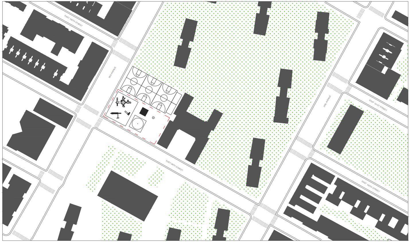
Cherry Tree Park, Creek Corner’s planned site, is a New York City Parks Department park located in the southwest corner of the George Washington Houses superblock. Originally named the George Washington Houses Playground of East Harlem, it was renamed Cherry Tree Playground in 1997 as an homage both to the cherry trees in the park as well as the apocryphal tale of President Washington and the cherry tree. The park opened in 1957 around the same time as the neighboring Washington Houses. It last received a major upgrade in 1996, which included new play equipment and refurbished courts (NYC Dept. of Parks and Recreation, “Cherry Tree Park,” n.d.).
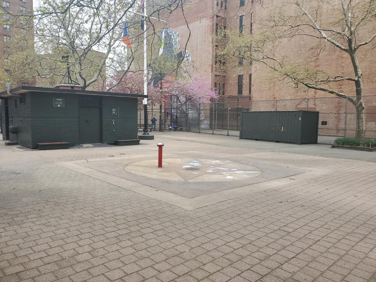
Current conditions at Cherry Tree Park (99th Street and Third Avenue), depicting play structure, basketball and handball courts, and the sprinkler system, which has been in place since the 1950s.
143
PROPOSALS |
Today, Cherry Tree Park has a variety of recreational facilities, including basketball courts, handball courts, a children’s play area with jungle gym and swings, as well as a spray shower. Additionally, located behind the sprinkler is a small building that houses restroom facilities and maintenance equipment for the Parks Department.
Creek Corner proposes utilizing a renovation to this dated element of the park to create an opportunity for learning, by illuminating the connection between Harlem’s historic marshland landscape and the superimposed modern-day grid, and allowing children to identify themselves, their homes, and other locations of significance in this historic landscape.
Existing Cherry Tree Park sprinkler.
Cherry Tree Park is a strong site for Creek Corner because it lies within the historic pathway of Harlem Creek, connecting this proposal intrinsically to the physical site of intervention more concretely. Further, Creek Corner would be located next to PS 109, a National Register and LPC-designated school building that is now the El Barrio Artspace). Despite being built on East Harlem’s marsh, the designation reports make no mention of PS 109’s sitting as an important element of its history. Instead, the report focuses more on PS 109’s survival in the midst of urban renewal (Herman 2018). As such, Cherry Tree Park is an appropriate site for a proposal that would elevate this untold history.
DESCRIPTION
Our proposal focuses on the portion of the park located along the western edge, where the children’s sprinkler is currently situated. According to the Parks Department, the water feature has not had any renovations or improvements since the park’s initial opening in March 1957.
Creek Corner’s proposed site plan, featuring a new sprinkler and wading pool system at the eastern edge of the park, implementing the historic path of the Harlem Creek and the modernday grid plan.
Open Source Data grid of Harlem used as a stencil for Creek Corner’s interactive map overlay.
144
| PROPOSALS
Historical map showing the Harlem Creek as it was in 1865.
Creek Corner first initiates the relocation of the washroom facilities from the center of the children’s play area to the northeast corner of the site, allowing for the installation to be opened up to the rest of the children’s space.
Using historic maps of the Harlem Creek, Creek Corner integrates a threedimensional set of waterpaths, to be carved out of the ground to create the bathymetry of the Harlem Creek. Atop the gently sloping creekbed, inlaid in metal is the current grid plan of Harlem, at the same scale as the Harlem Creek interpretation, to show where the Harlem Creek would flow through Harlem, had it not been drained, filled, and built on. By placing a water sprinkler at the northwesternmost corner of the daylighted mini-creek, its water flows through the sprinkler and rushes into the paths of the waterbeds. This aquatic activation of Creek Corner enables the waters of Harlem Creek to flow through the neighborhood once again.
By allowing these two histoires to intersect, we hope to illuminate the environmental injustice of Harlem, allowing children and their parents to explore the new mini landscape, and physically find their location, their home, their school and see where it would have fit into an earlier Harlem. By embedding this historical context back into the neighborhood, we hope to shed light on a since-buried history of infill locations, areas of land reclamation, and changed landscapes over time.
Materially, Creek Corner implements tactile, pervious materials to draw attention to the native soils and marshes of pre-urbaned Harlem, allowing children to explore this topography in hopes that they would be able to interact with history, and gain an understanding of the true threat of climate change through material, history, and site.
Creek Corner raises awareness about climate and memorializes the past histories of Harlem. By taking these issues which are difficult to visualize due to scale and time and giving them physical space to inhabit and be interacted with through play, it can support community-led movements towards addressing them.
We believe that by “daylighting” the historic waterways of East Harlem and its inherent vulnerability to climate change, while overlaying the grid of the streets as water from the sprinkler flows children will begin to connect material, land mass, and vulnerability in a educational, interactive, and tactile way to highlight broader vulnerability challenges. While creating an educational playground for children, this project would also help improve a critical necessity for Harlem residents in the summer, helping to keep them cool on hot summer days. Used outside of the summertime, when the sprinkler system is off, the gentle dips in elevation of the waterbeds could be used as general park space, continuing the thread of childsplay year round.
145
PROPOSALS |
IMPLEMENTATION
In order to make Creek Corner a reality, a variety of New York City organizations and individuals would be consulted. There are two primary groups that Creek Corner would solicit input from: organizations that act as local stakeholders for Cherry Tree Park and individual collaborators who would help refine specific design and curricular elements of Creek Corner.
The primary organizational collaborator for Creek Corner would be the NYC Parks Department. They not only have jurisdiction over Cherry Tree Park, but are also a part of the aforementioned “Cool It!” program, which seeks to make cooling features more accessible to residents. As such, Creek Corner would be realized through their capital construction projects and ongoing maintenance and
Rendered image collage illustrating children at play in the rethought Creek Corner.
program management. Creek Corner would also connect with local communitybased organizations, including Community Board 11 and the Washington Community Improvement Council, a resident-led coalition between George Washington and Washington Carver House residents.
Creek Corner would also seek out individual collaborators to help realize this proposal. Since Creek Corner borders the El Barrio artspace, artists who live and work there would be prioritized to help with this project. Additionally, Creek Corner would look for local educators and teachers who may want to integrate climate change and histories thereof into their curriculums. The ultimate goal is to bring a variety of voices together in a resident-led, grassroots design workshop process that can help make Creek Corner a reality.
146
> Climate Risk and Response > Energy > Fresh Food and Nutrition Access > Hazardous Materials Exposure > Indoor Air Light and Ventilation > Open Spaces and Green Resources > Outdoor Air > Redevelopment and Displacement > Solid Waste Management > Transportation > Water Quality & Management This appendix comprises the full historic context analyses for the studio’s eleven faculty-identified themes representing the concerns and histories associated with environmental justice and land use in Harlem: APPENDIX A: HISTORIC CONTEXT ANALYSES
CLIMATE RISK AND RESPONSE
Emily Conklin and Kemuning Adiputri
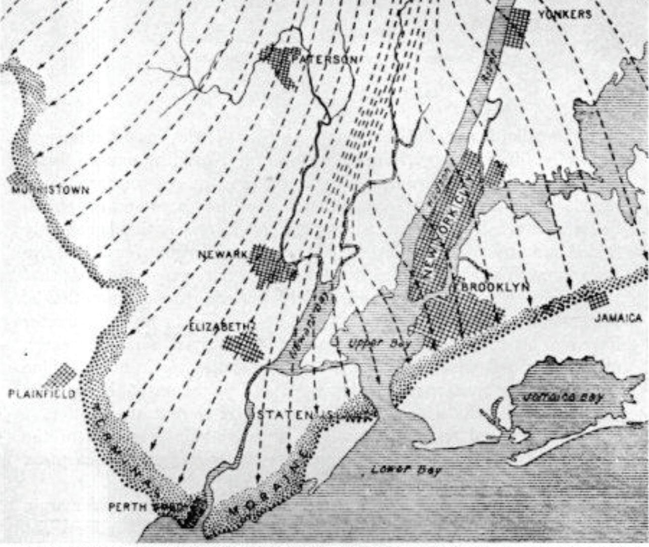
New York City and vicinity, showing position of the terminal moraine and directions of the ice movement (indicated by the arrows) during the last or Wisconsin glaciation. United States Geological Survey.
GEOLOGIC HISTORY AS PRECONDITION: LAND-BASED INEQUITIES
New York City’s rivers, ridges, and valleys were created during the last ice age, approximately 22,000 years ago, by the Wisconsin Glacier. The area was the southernmost point of the glacier’s reach, and evidence of its movements and debris dispersal are evident in the terminal moraine stretching throughout the
boroughs, as well as rock formations throughout, which are particularly visible in Central Park. Harlem’s landscape shows evidence of this glacial history through steep cliffs of schist to the west, sloping down towards the Hudson River, and a low valley leading to marshland to the east, meeting the Harlem River.
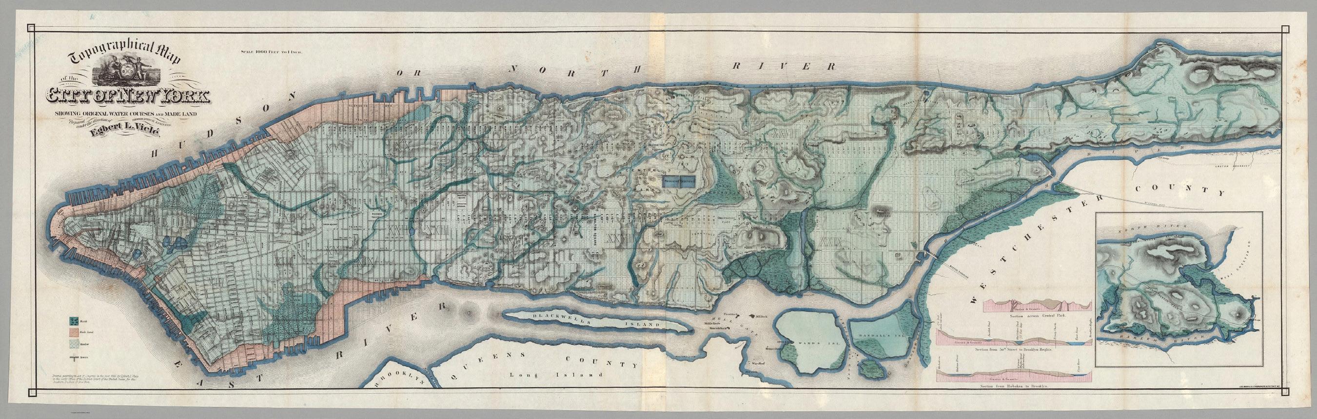
Detail of the Viele Map showing original waterways and systems, c. 1865.
There is a notable elevation difference between the “heights” to the west and the “valley,” or Harlem Marsh, to the east, from as high as 200 feet to just 15 feet above sea level, respectively. This creates a condition where the west side’s rock elevations protect land, property, and people from flooding, while the waterways, lowlands, and valley conditions to the east are more vulnerable in the event of a heavy storm or natural disaster. These distinct landscapes establish unequal climate risk conditions that underlie urban development and infrastructural design.
164
| APPENDIX A: HISTORIC CONTEXT ANALYSES
Section along 125th Street, showing elevation change and soil makeup.
Harlem is also filled with myriad hidden waterways, well documented on historic maps and visible in many nineteenth and early twentieth century fire insurance atlases. These small creeks, streams, and ponds indicate places in the landscape where waters naturally flowed, gathered, and drained into the adjacent rivers, and also irrigated farmland and soils. However, as development persisted in the area, and in Manhattan more generally, these streams and creeks were ill-used and became a nuisance rather than a natural asset. Waste dumping and animal feces polluted many of the streams, and flooding damaged crops and properties. Downtown, City Hall itself was built on the site of the former (infamous) Collect Pond, a cesspool of human and animal wastes, trash, and soot that became so offensive to public health that the city had it drained and infilled in 1811. This trend continued as the city expanded northwards following the layout of the grid and was also often accompanied by leveling topographies that challenged an even plane of development.
Heat
Despite infill and dynamite, Harlem shows many signs of its natural landscape, from its previously mentioned dynamic elevation changes to the rocky outcrops at the mountain of Mount Morris (also known as Marcus Garvey Park). These landscapes also remind us that nature triumphs over the most carefully planned manmade interventions. Old streams and creeks will reappear in subway tunnels
165
APPENDIX A: HISTORIC CONTEXT ANALYSES |
map overlay of Harlem with green to red tones delineating higher elevations.
despite hydraulic pumps meant to keep water out. Low-elevation streets or roads located over river infill, like East 106th Street, will flood in heavy rain, becoming veritable rivers themselves. The Harlem Marsh encompasses most of East Harlem, as indicated by the blue streams and green areas on the accompanying map, and these marshy conditions persevere despite the addition of asphalt overlay and apartment buildings. The geological character of Harlem provides a necessary basis for analyzing and understanding the environmental conditions of the studio study area.
that was moist, close to sea level, and characterized by a system of streams and rivulets, draining rainfall and other streams from the heights on the west side of Manhattan Island. Even early in Harlem’s post-settler colonial history as farmland, the marshiest areas on the riverfront were left undeveloped, with farms starting to sprout around what we now know as Second and Third Avenues. However, as several consecutive fire insurance atlases show, the steady development from the south meant that even these marshes surrendered to the grid, and decade by decade, new streams were taken off the atlas maps as avenues were laid over their drained beds. East 107th Street is constructed almost entirely over a preexisting large stream, depicted on the Viele map of Manhattan. Subsequent areas between First and Third avenues from 96th to 104th Streets on the south of the study area, as well as further north between East 114 and East 122nd Streets, are also buried streams whose outlets fall into the Harlem River.
Details of the Viele Map, showing large stream systems in East Harlem marsh, c. 1865.
FLOOD RISK AND RESPONSE
While Harlem has been a marshland and therefore a natural floodplain for centuries, intensive development in the last 200 years has meant that natural flood events have come with a cost to human existence in the neighborhood. The East Harlem neighborhoods between Fifth Avenue and the Harlem River, stretching from East 96th Street to East 155th Street, have been most heavily impacted. According to our geological research, this area was once the Harlem Marsh, a lowland area
Detail of fire insurance map showing the expansion of the grid northward and construction over existing waterways, c. 1891.
These two maps illustrate the most prominent areas of land lying on the Harlem Marsh, which is occupied today by many NYCHA housing complexes, multi-family apartment buildings, and multi-use storefronts. The area is serviced by the 6 train, whose infrastructure chronically floods. This marsh was infilled with solid waste to “reclaim” land for Manhattan’s development, and this ongoing flood vulnerability impacts the populations who live there.
Another prominent historic waterway is the Harlem Creek, visible on almost every fire insurance atlas and depicted in bold on the Viele map. This creek ran from West 116th Street down to the Harlem Meer, and was also fed by Montagne’s Rivulet. This creekbed explains the depression in land grade in Central Harlem, and is buried beneath the major subway express lines of the 2, 3, A, C, B, and D trains that traverse tunnels from Central Park West to the central vein of Harlem up to the 125th Street depot.
166
| APPENDIX A: HISTORIC CONTEXT ANALYSES
However, flood vulnerability is not solely based on the presence of historical waterways, as the west side of Harlem is littered with streams feeding into the Hudson. The area’s topography is also a factor in East Harlem’s frequent sewer overflows: water flows down from the heights through the plains of East Harlem, overworking the water maintenance systems on that side of the island. Together, these two geological realities have combined to create a perfect storm for East Harlem residents for decades.
The Federal Emergency Management Agency (FEMA) has outlined data for the 100and 500-year floodplain locations for many cities that are at risk for flooding and increasing negative effects from climate change and sea level rise. In New York City, a large percentage of the floodplain danger is in East Harlem. FEMA, as well as the open data nonprofit First Street, have collected data and run simulations on the Harlem floodplain’s performance during several historic flood events. Their findings show that Harlem has likely always flooded, and will continue to flood with increased severity (Risk Factor, n.d.).
Harlem’s geography and topography establishes conditions of environmental inequality, with different areas of the neighborhood being more prone to flooding. The area has not received funding or infrastructural support to mitigate these environmental stressors when compared with other, wealthier at-risk areas of New York City, underscoring further injustice. One example of this inequity can be seen in the city’s major investment into the coastal resiliency program for the Lower East Side, a neighborhood that has changed dramatically and is now an expensive enclave. The East River Park that services this neighborhood is set to have millions of dollars invested in soft landscape upgrades, new park facilities and amenities, and above all, flood protection for that neighborhood (NYC Dept. of City Planning, “East River Waterfront Study,” n.d.). None of these plans extend upwards to Harlem, which was hit as hard as or harder than the Lower East Side by Hurricane Sandy.
EXTREME HEAT HISTORY AND HEAT PROSTRATION REPORTS
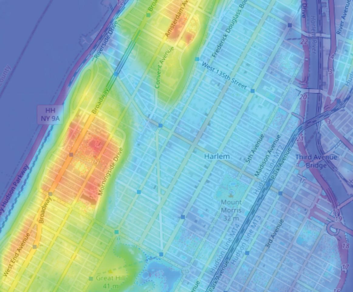
Harlem has been documented to have high vulnerability to extreme heat conditions and is one of the warmest neighborhoods in New York City (Vant-Hull et al. 2014; Rosenzweig et al. 2006). As wind moves from south to north during a heatwave, the air is heated by the buildings on the southern end of the island, causing the wind to become warmer before it reaches Harlem. The high ridge on the west side reduces the prevailing surface wind, further increasing the temperature in Harlem (Ramamurthy et al. 2017).
Historically, Harlem also has had fewer street trees, and the 1995 tree census of Manhattan still portrayed the Harlem area to have less tree density than the rest of the island (NYC Dept. of Parks and Recreation 2015). The lack of shade on the street allows more sunlight penetration, which causes a warmer urban fabric, leading to extreme heat danger.
There are also fewer hours of shade produced by buildings in Harlem due to their average lower height. Structures in Harlem mainly consist of residential buildings built between 1900 and 1940, which are generally lower in height (4.6 floors tall on average) compared to the business area around lower Manhattan (the average height for all of Manhattan is 6.3 floors) (Vant-Hull et al. 2018). Within Harlem itself, Central Harlem and South Harlem are documented to have lower buildings than West Harlem (based on the PLUTO dataset; see NYC Dept. of City Planning 2022), indicating even greater heat risk.
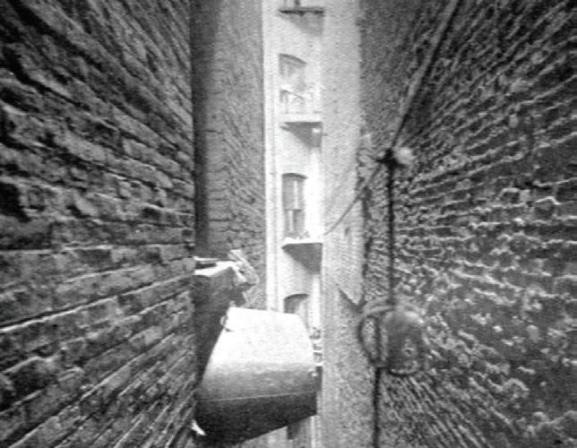
In addition to building heights, the interior living condition among residential buildings in Harlem is another characteristic of the built environment in Harlem that affects heat vulnerability. As discussed in the Indoor Light, Air, and Ventilation historic context, 48 percent of housing in Harlem documented in 1969 was built during the era of Old-Law Tenements. This type of residence utilized 90 percent of the lot area for built space, with very minimal interior air shafts and narrow courts between buildings for ventilation. This resulted in minimal air circulation, which trapped stagnant warm air inside, increasing Harlem residents’ vulnerability during extreme heatwaves.
167
1995 Street Tree Census. Data Source: New York City Open Data.
APPENDIX A: HISTORIC CONTEXT ANALYSES |
The availability of open space in Harlem indirectly affects the increasing heat vulnerability of this area as well. Before 1900, Harlem residents often utilized undeveloped land and streetscapes as public spaces in response to the lack of parks in this neighborhood (Gill 2012, 256).


While it is apparent that the Harlem area is a vulnerable neighborhood during heat waves, what is the effect of this danger to the residents of Harlem? For hundreds of years, newspapers have reported heat prostration victims and heat casualties in Harlem. The accompanying map illustrates areas of concentration where heat victims were reported in the media between the 1880s and the 1940s. While this data is neither a comprehensive accounting of heat prostration cases in Harlem nor relative to the city as a whole, it provides a perspective on the prevalence of the problem in Harlem.
The first map shows whether the victims survived or not after prostration, while the second map shows the year when the case was reported. The maps indicate that Central Harlem and South Harlem have denser recorded cases than West Harlem, with particular patterns of concentration, such as a linear arrangement of dots along 125th Street.
Harlem mostly consists of low-rise buildings.
Heat prostration map based on reported year.

168
Narrow courts between Old-Law Tenement buildings. Street gathering in Harlem.
| APPENDIX A: HISTORIC CONTEXT ANALYSES
HEAT RISK MITIGATION: DEVELOPMENT OF COOLING FACILITIES
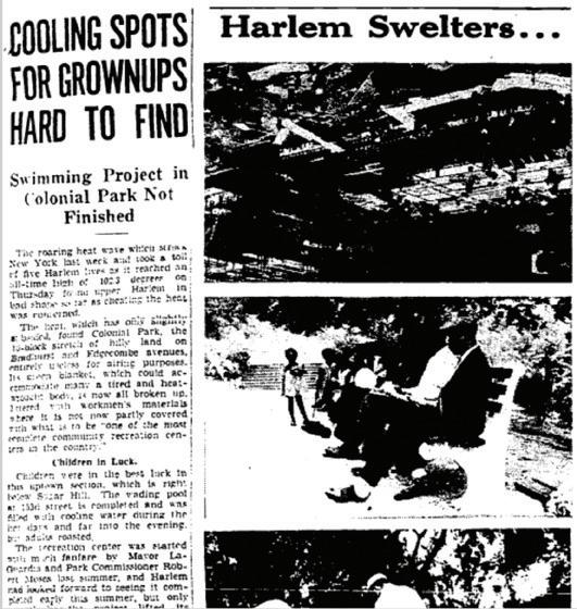
The establishment of cooling facilities suggests a response to mitigate extreme heat risk. One newspaper article from 1936 reported heat prostration casualties and the lack of public cooling facilities in Harlem. The caption says, “Cooling Spots for Grownups Hard to Find.” It notes the in-progress development of Colonial Park (now Jackie Robinson Park) and mentions the facilities it will provide after its completion: pool, benches, and greenswards (New York Amsterdam News 1936). The Jackie Robinson Pool was the first public pool for adults in Harlem. Considering that the first pool built in Manhattan was the West 60th Pool, developed in 1906, it shows how late the development of cooling facilities and public spaces was in Harlem compared to other neighborhoods.
The establishment of drinking fountains in Manhattan has a similar pattern. Some existing drinking fountains in Manhattan were documented back in 1899 (NYC
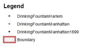
Dept. of Parks and Recreation 2019). All of those earlier drinking fountains were established in Lower Manhattan and Midtown, indicating a pattern of progression from the southern parts of the island to the north. Harlem residents’ minimal access to cooling facilities increased the risk of extreme heat in the neighborhood, as relief from the heat was hard to find in the past.
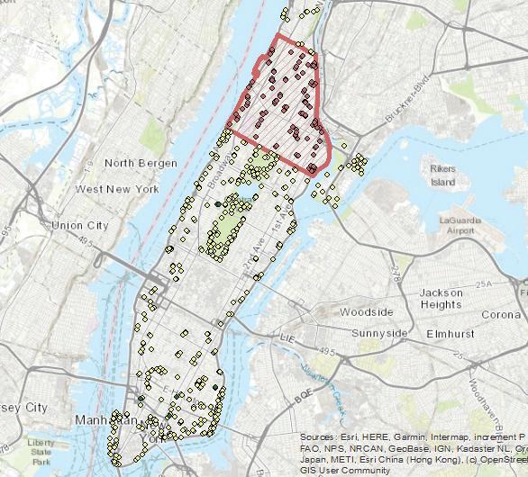
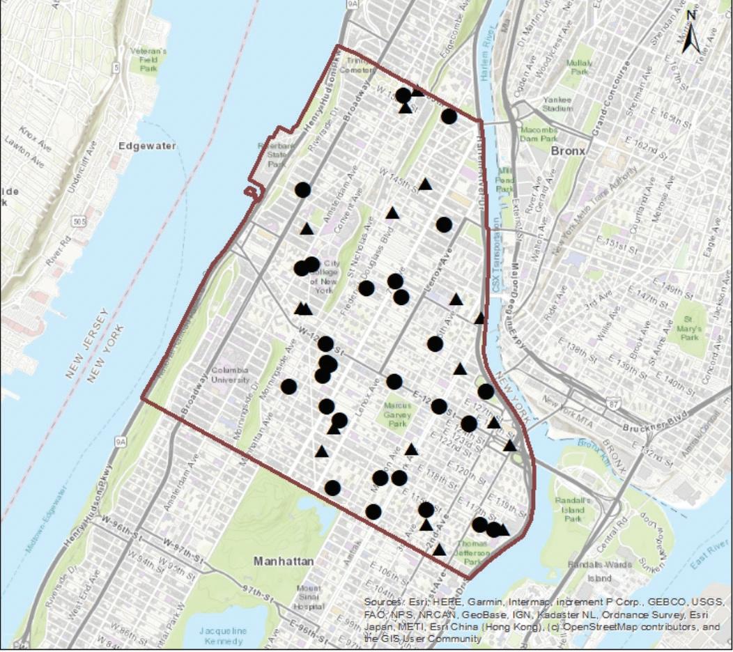
Existing drinking fountains in Manhattan.
New York Times headline about the lack of cooling facilities.

Heat prostration map based on victim condition.

169
APPENDIX A: HISTORIC CONTEXT ANALYSES |
