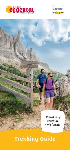

33 trekking routes & 4 via ferrata

Symbols:
“KIRCHSTEIG” TO THE STONE AGE SETTLEMENT OF ENZBIRCH
This Stone Age settlement includes a hilltop with heavy overgrowth, the ruins of a walled fortress, and great views of the Adige Valley.
ROUTE: Deutschnofen | Nova Ponente (1357 m), Piazza Gibitz –left towards Wölfl farm – left onto the church trail K (Kirchsteig) –across meadows and past beautiful farmsteads – on trail n. 10 to Högger farm (1h) – Schadner farm – trail R – downhill to the rocky outcrop. Return: trail n. 10 – Wölfl farm – trail E5 – village centre (2 h).
VARIANT RETURN: Högger farm – church trail K (Kirchsteig), trail n. 11B – Wölfl farm – trail E5 – village centre (2 h).


PANORAMA CIRCULAR HIKE
Easy and pleasant walking tour with a stunning view of the Dolomites and Alps.
ROUTE: Deutschnofen | Nova Ponente (1357 m), Piazza Gibitz – roundabout at the village entrance/Bar Luise – along the road to the Pfösl Chapel – take first trail n. 6 left downhill – after 1 km right onto trail P – “Schlernblick House“ (splendid view) – Weissbamer farm (possible short-cut to St. Helena | S. Elena church in 10 min.) –trail P – across the road right on trail P – Hotel Pfösl (10 min.) or trail H behind the Untermoser farm – Bühl farm – Deutschnofen | Nova Ponente (1 h).


EUROPEAN LONG DISTANCE PATH E5: FROM DEUTSCHNOFEN | NOVA PONENTE TO KOHLERN | COLLE AND TO BOZEN | BOLZANO
Varied walking tour on the wooded plateau.
ROUTE: From the village centre of Deutschnofen | Nova Ponente (1357 m), proceed on trail E5, n. 1 until you reach the Wölfl farm (1 h) – take forest trail n. 1 to the “Toten Moos” (1 h) & to the view points “Rotstein” & “Rotwand” – trail n. 1 to the Schneiderwiesen Inn – Colle di Bauernkohlern | Colle di Villa (2 h). Take the cable car to Bolzano (please check times!). From the valley station in Kampill, take the city bus (runs half-hourly) to the centre. Return to Deutschnofen | Nova Ponente by bus (line 181).

12 km 3-4 h 500 m
Petersberger Leger hut, Gasthof Weissenstein | Albergo Pietralba, Laab hut
TO THE PILGRIMAGE SITE OF WEISSENSTEIN | MADONNA DI PIETRALBA
Nice excursion between meadows and forest to Pietralba, the most famous pilgrimage church in South Tyrol.
ROUTE: Deutschnofen | Nova Ponente (1357 m), parking at Bar Arche (ski lift) – path n. 1 to Bühl farm and Laab hut – path n. 1B to Petersberger Leger hut – path n. 2 to Weissenstein | Pietralba – pilgrimage path n. E5 back to Deutschnofen | Nova Ponente.
Points 10 Stamp
PETERSBERGER LEGER HUT | MALGA MONTE S. PIETRO, LAAB HUT

TO THE LIEG HUT

VARIANT 1: Along the road to Deutschnofen | Nova Ponente – parking between Hotel Ganischgerhof and Hotel Schwarzenbach – path n. 9 A to the Bajerlsäge – path n. 9 – Lieg hut (1750m).
Return: on the same path.
VARIANT 2: From Lavazè Pass | Passo Lavazè –path n. 9 – Lieg hut, easy, also for children (1 h).
VARIANT 3: Village centre of Deutschnofen | Nova Ponente – Bar Luise – path n. 1 – Bühl farm –path n. 8 on the left – path n. 9 on the right to Eggel farm – Bajerlsäge path n. 9 – Lieg hut (3 h).
RETURN: Bajerlsäge path n. 9 and to Deutschnofen | Nova Ponente.
TO THE LAAB HUT AND TO THE PETERSBERGER LEGER HUT
Magnificent high-altitude walk starting from the Laab hut to three traditional huts.
ROUTE: The the Laab Alm is accessible by car. The starting point of the hike is the Laab Alm hut (1649m). Proceed easily along Forest Trail n. 1 until you come to the Neuhütt Alm (1791 m). Continue along Trail n. 2 to Petersberger Leger Alm (1530 m). On Trail n. 1B, you can return to the Laab Alm.

6.8 km 2 h 314 m
Laab hut, Petersberger Leger hut, Neuhütt hut easy
TO THE CHURCH S. AGATA | ST. AGATHA
ROUTE: Deutschnofen | Nova Ponente (1357 m) – Via Castel Thurn – path n. 5 – Oberkofl farm – path n. A to the church St. Agatha | S. Agata – Unterkofl farm – Deutschnofen | Nova Ponente.
VARIANT: back to the Oberkofl farm – forest path n. 5 – Thaler farm – Hotel Kreuz at Birchabruck | Ponte Nova – bus stop and back to Deutschnofen | Nova Ponente by bus (line 181) (2.5 h).


TO THE BLETTERBACH GORGE
A hike with many geologically interesting sights into the Bletterbach gorge.
ROUTE: Pilgrimage site of Weissenstein | Pietralba (1520 m), Pilgrims’ House – path n. 15 – trail E5 and path n. 3 to the Lahner hut (1 h) – Geo Center Bletterbach – down into the riverbad and gorge – “Gorz” trail – gorge-trail back to the Geo Center – Lahner hut (1 h) – path n. 3 – Köser Tal valley – trail E5 and path n. 15 back to Weissenstein | Pietralba (helmet recommended).

TO THE WEISSHORN | CORNO BIANCO
A climb to the summit, with a uniquely beautiful panoramic view from the top.
ROUTE: Pilgrimage site of Weissenstein | Pietralba (1520 m), Pilgrims’ House – path n. 15 to “Pichlwies” – trail E5 through Köser Tal valley – trail n. 5 to the top (2317 m) (3 h). Return: Jochgrimm | Passo Oclini – path n. 1 – Neuhütt hut – path n. 2A and trail E5 through the Köser Tal valley to Weissenstein | Pietralba (3 h).

ROUNDTRIP HIKE THROUGH ALPINE MEADOWS ON THE JOCHGRIMM | PASSO OCLINI
This pleasant roundtrip hike brings you to places with stunning vistas of beautiful landscapes.
ROUTE: Drive by car to the Auerleger hut (1872 m) (Lavazé Pass | Passo Lavazé - Jochgrimm | Passo Oclini) (1989 m) – parking –path n. 2 to the Jochgrimm | Passo Oclini – to the Gurndin hut –path n. 12A to the Isi hut – path n. 7 – Jochgrimm | Passo Oclini –back to the Auerleger hut.

Points 10 Stamp
GURNDIN HUT


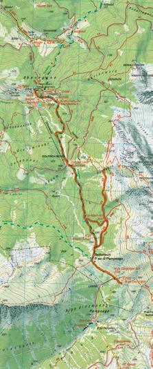
LATEMARIUM – LATEMAR.PANORAMA
This adventure-hiking trail directly beneath the walls of the Latemar will guide you to the region’s most-spectacular outlook points, with lots of educational and informative fables of these places.
ROUTE: Obereggen – ascent with the chair lift Oberholz to the alpine hut Oberholz (2096 m) – path n. 18 – platform
Latemar.360° – path n. 22 – Feudo Pass | Passo Feudo (2175 m) –path n. 504/505 – Reiterjoch | Passo Pampeago – path n. 9 –Epircher Laner hut – Obereggen.

Alpine
TO THE TORRE DI PISA HUT
This is a challenging hike over mountain slopes and rocky terrain to the Latemar, on to the Forcella dei Camosci Gap, over the summit and to the Torre di Pisa hut. It affords a beautiful panoramic view.
ROUTE: Obereggen (1550 m) – ascent with the chair lift Oberholz to the alpine hut Oberholz (2096 m) – uphill on path n. 18 – Forcella dei Camosci Gap (2560 m) – path n. 516 – Torre di Pisa hut (2671 m).
Descent on paths n. 516 and n. 22 to the Mayrl hut – path n. 23 (20 min.) to the mountain station of the chair lift Oberholz. Return via the chair lift Oberholz to Obereggen.
VARIANT: Down path n. 516 to the Feudo Pass | Passo Feudo –path n. 504 to the Zischg hut and Ganischger hut – path nr. 505 and n. 9 back to Obereggen.
Torre di Pisa hut, Mayrl hut, Ganischger hut, Zischg hut, Epircher Laner hut, Alpine hut Oberholz, Platzl Mountain Lounge, Loox difficult

TO THE HUTS OF OBEREGGEN
A panoramic hike across alpine meadows below the impressive mountain scenery of the Latemar and the Zanggen.
ROUTE: Obereggen (1550 m) – upper parking – “Alm” path n. 9 – uphill to the Epircher Laner hut (40 min.) – path n. 9 after 1 km take the left path n. 23 up to the Mayrl hut (30 min.) or on to the Reiterjoch | Passo di Pampeago (1996 m) – path n. 505 to Ganischger hut and Zischg hut (30 min).
RETURN: to the Mayrl hut – 20 min. to the mountain station of the chair lift Oberholz (50 min. from the Zischg hut) or back on path n. 9 to Obereggen.
9 km 2-4h 500 m
Alpine hut Oberholz, Epircher Laner hut, Mayrl hut, Ganischger hut, Zischg hut, Platzl Mountain Lounge, Loox moderate


HIKE OVER THE SAMBERG MOUNTAIN
A somewhat arduous, but rewarding forest hike with lots of panoramic views.
ROUTE: Eggen | Ega (1120 m), village square – path n. 7 – Grott farm – path S – Häusler Sam hut (3 h).
RETURN: trail n. 8 to Bewaller farm – trail n. 8B – Städtl path n. 10 to Eggen | Ega.


ALONG THE TEMPL PATH TO LAKE CAREZZA
An interesting tour, especially for families with children, from Obereggen through the forest to the famous Lake Carezza. Hikers can also start from Eggen | Ega or vice versa.
ROUTE: Obereggen (1550 m), upper parking – path n. 9 – Bewaller farm – path n.8 – possible detour on to the Häusler Sam hut – path S or path n. 25A and n. 25 to Stadl Alm hut – path n. 8 to Lake Carezza – back on the same path.
VARIANT: Start from Eggen | Ega – path n. 10 – then on path n. 8B and on as described above.

12-14 km 3-4h 150 m
Stadl Alm hut, Häusler Sam hut easy
STADL ALM HUT, HÄUSLER SAM HUT Points 5 Stamp

FROM WELSCHNOFEN | NOVA LEVANTE TO LAKE CAREZZA
Lake Carezza is one of the most beautiful alpine lakes and is known for its wonderful colours.
ROUTE: Parking lot cable car Welschnofen | Nova Levante (1182 m) – along the main street 500 m in the direction of Bozen | Bolzano until the civil defence centre – path n. 10A –Hotel Adler – path n. 10A – Lake Carezza (1520 m) – path n. 10A – Hotel Adler – path n. 7A – path n. 7 – parking lot cable car Welschnofen | Nova Levante.
VARIANT: From Hotel Adler – path n. 27 or n. 25 – Stadl Alm hut –path n. 27 – civil defence centre – main road back to the parking lot cable car Welschnofen | Nova Levante. Duration: 5 h; Height difference ascent: 675 m; Length: 14.6 km.

SISSI TOUR
Destination of this lovely hike is the monument to the Empress Elisabeth (Sissi, wife of Franz Josef I), who stayed several times in the Grand Hotel Carezza. She was often accompanied by a local guide along the path n. 6, which was her favorite walk.
ROUTE: Lake Carezza (1520 m) – suspension bridge – path n. 6 –grain mill – path n. 6 – Meierei inn – Ladritscher farm – path n. 3 –Elisabeth monument (1566 m) – back to the crossing – path n. 6 –path n. 16 to the chairlift Tschein – path n. 6 – suspension bridge –Lake Carezza.
VARIANT: From Elisabeth monument – path n. 3 – path n. 3A –parking lot cable car Welschnofen | Nova Levante. Duration: 2 h; Height difference ascent: 68 m; Length: 6.5 km.
easy - moderate
9.9 km 3 h 357 m
Meierei
ELISABETH MONUMENT Points 10 Stamp


FARM HIKE
With the fabulous view of the surrounding Dolomite mountains Rosengarten | Catinaccio and Latemar, this hike is an absolute Must-Do here in Val d‘Ega.
ROUTE: Church square Welschnofen | Nova Levante (1182 m) –path n. 5 – pilgrimage chapel Lengeria – wolf pit – path n. 1 –Schiller farm (1555 m) – path n. 4A – Hagner hut (1550 m) –path n. 4B – path n. 15A – path n. 15 – path n. 5 – church square Welschnofen | Nova Levante.
VARIANT: Welschnofen | Nova Levante – ascent by cable car Laurin I – Frommer hut – path n. 1A – Nigerpass | Passo Nigra –path n. 1 – path n. 4A – Hagner hut – path n. 4A back to Welschnofen | Nova Levante (Duration: 3.5 h; Height difference ascent: 37 m; Length: 12.5 km) or return on path n. 1 – Schiller farm –path n. 1 and n. 5 back to Welschnofen | Nova Levante (Duration: 3 h; Height difference ascent: 36 m; Length: 11 km).


LATEMAR LABYRINTH
Latemar forest is home to the hazel spruce, a wood used to manufacture string instruments. Therefore, it is also called “tonewood”. From the Latemar forest you can reach into the popular rock labyrinth, which got its name from the boulders, which are as high as houses and which are the result of a huge landslide from the Latemar long ago.
ROUTE: Bus stop Karerpass | Passo Costalunga (1752 m) – path n. 21 to the Mitterleger | Radura di Mezzo (1839 m) – Labyrinth path n. 20 – turn left on path n. 18 – turn right on path n. 21 –path n. 21 – Karerpass | Passo Costalunga.

MASARÈ PATH
Along this panoramic path you will see an eagle made of bronze – this is to commemorate Theodor Christomannos, who built the legendary Dolomite road from Welschnofen | Nova Levante to Cortina.
ROUTE: Mountain station chairlift Paolina (2125 m) – path n. 539 –Christomannos monument (2349 m) – path n. 549 – Fronza alle Coronelle | Kölner hut (2337 m) – path n. 549 and n. 552 – chairlift Paolina.
VARIANT: Welschnofen | Nova Levante – cable car Laurin I –Frommer hut – cable car König Laurin I and II – Fronza alle Coronelle | Kölner hut – the round in the opposite direction.

Paolina hut, Fronza alle Coronelle | Kölner hut, Laurins Lounge, Frommer hut
Stamp
MASARÈ PATH N. 549 (BIG STONE CROSSING
VAJOLONPASS | PASSO VAJOLON)
Points 10

CIRCULAR HIKE AROUND THE ROSENGARTEN | CATINACCIO MASSIF
This hike offers a fantastic view of the surrounding mountains for those who like walking and have mountain experience.
ROUTE: Welschnofen | Nova Levante (1182 m) – cable car
Laurin I – Frommer hut (1743 m) – cable car König Laurin I and II –Fronza alle Coronelle | Kölner hut (2337 m) – path n. 550 –Tschagerjoch | Passo Coronelle (2630 m) – path n. 541 – Cigoladepass | Passo Cigolade (2550 m) – path n. 541 – Roda di Vael | Rotwand hut (2283 m), Pederiva hut (2275 m) – path n. 549 –path n. 539 – Paolina hut (2125 m) – path n. 552 – path n. 549 –Fronza alle Coronelle | Kölner hut.
VARIANT: From Paolina hut – the round in the opposite direction. Challenging hike; walkers must be well-equipped and have a head for heights.

11.5 km 5 h
780 m
Frommer hut, Fronza alle Coronelle | Kölner hut, Laurins Lounge, Roda di Vael | Rotwand hut, Pederiva hut, Paolina hut
Points 20 Stamp

TO THE POPPEKANZEL | PULPITO IN THE LATEMAR
The exhausting ascent will be repaid by an amazing view of the surrounding mountains like the Pala Group, Marmolada, Sella, Sassolungo, Rosengarten | Catinaccio and Ötztal Alps.
ROUTE: Karerpass | Passo Costalunga (1752 m) – path n. 17 –mountain cinema – Poppekanzel | Pulpito peak (2328 m) – back the same way.
Challenging hike; walkers must be well-equipped and have a head for heights.


KING LAURIN TOUR
This hike takes you to the highlights between Latemar and Rosengarten | Catinaccio.
ROUTE: Parking lot cable car Welschnofen | Nova Levante (1182 m) – Laurin I cable car – Frommer hut – cable car König Laurin I and II – Fronza alle Coronelle | Kölner hut (2337 m) – Masarè path n. 549 – path n. 552 – Paolina hut (2125 m) –descent with Paolina chairlift – path n. 6 – path n. 10 – Lake Carezza (1520 m) – suspension bridge – path n. 6 – path n. 16 –chairlift Tschein – descent with cable car König Laurin I and cable car Laurin I to Welschnofen | Nova Levante.

INTO THE HEART OF THE ROSENGARTEN | CATINACCIO MASSIF – VAJOLON
Very nice excursion in the heart of the Rosengarten | Catinaccio massif. The hike offers a fantastic view of the nearby mountains.
ROUTE: Karerpass | Passo Costalunga (1752 m) – path n. 552 –Hirzel path – path n. 9 – Vajolonpass | Passo Vajolon (2560 m) –path n. 551 – path n. 541 – Pederiva hut (2275 m), Roda di Vael | Rotwand hut (2283 m) – path n. 548 – Karerpass | Passo Costalunga.
Challenging hike; walkers must be well-equipped and have a head for heights.


TO THE CHRISTOMANNOS MONUMENT
You will enjoy the marvellous view of the surrounding mountains.
ROUTE: Parking lot Kaiserstein (1744 m) – path n. 1A –path n. 548 – Roda di Vael | Rotwand hut (2283 m), Pederiva hut (2275 m) – path n. 549 – Christomannos monument (2349 m) –path n. 539 – Paolina hut (2125 m) – path n. 552 – path n. 6A –Masaré hut – forestry road – path n. 1A – parking lot Kaiserstein.
SHORT VARIANT: Mountain station chairlift Paolina (2125 m), Paolina hut (2125 m) – path n. 539 – Christomannos monument (2349 m) – path n. 549 – Pederiva hut (2275 m), Roda di Vael | Rotwand hut – same way back. Duration: 1.5 h; Height difference ascent: 153 m; Length: 3.8 km.
Pederiva hut, Roda di Vael | Rotwand hut, Paolina hut, Masarè hut easy
MASARÈ HUT Points 10 Stamp

TO THE MESSNERJOCH HUT
Excursion for everybody with breathtaking view.
ROUTE: Parking lot cable car Welschnofen | Nova Levante (1182 m) – path n. 3A – Niger path – Nigerpass | Passo Nigra (1688 m) – path n. 1 – Messnerjoch hut (1930 m) – back the same way or path n. 1B, n. 15, Niger path and n. 3A.
SHORT VARIANT: Welschnofen | Nova Levante – cable car Laurin I – Frommer hut – path n. 15 and n. 1B – back the same way (Duration: 1.5 h; Height difference ascent: 200 m; Length: 3.4 km).

Points 10 Stamp

VIAL DE LE FEIDE (SHEEP PATH)
High-altitude hike between Vigo di Fassa and Carezza with breathtaking panoramic views.
ROUTE: Parking lot cable car Welschnofen | Nova Levante (1182 m) – by bus to Vigo di Fassa (line 180) – cableway Ciampedie – Ciampedie (2000 m) – Vial de le Feide (Sheep path) – path n. 541 – Roda di Vael | Rotwand hut (2283 m), Pederiva hut (2275 m) – path n. 549 – path n. 539 –Paolina hut (2125 m) – descent with chairlift Paolina – return by bus to Welschnofen | Nova Levante.

CIRCULAR HIKE TALTBÜHL
Circular walk with panorama view across the romantically situated “Totmoos” up to the last wolf pit of the area. The path leads then towards Niger Pass | Passo Nigra and Rosengarten | Catinaccio.
ROUTE: Bus stop Obergummer | S. Valentino di Sopra (1350 m) or car park in front of „Lärchenwald“ – path n. 3 – at the farm Weggut junction turn left n. 22 – Totmoos (1625 m) – path n. 22 –Wolf pit (1506 m) – path n. 1 – Schiller farm (1555 m).
RETURN: path n. 1 – parking place in front of „Lärchenwald“ or bus stop Obergummer | S. Valentino di Sopra


STEINEGG | COLLEPIETRA HIKING PATH
Very nice circuit with breathtaking panoramic view.
ROUTE: Bus stop or parking Egger Moos (1522 m) –yellow shoe shield path and path n.5 – Kaserer Bild (1278 m) – path n. 5 – Lärch farm (1310 m) – Oberölgart farm (1201 m) – path n. 6 – follow the forest road with yellow shoe markings (do not turn off to Steinegg | Collepietra) –Soluck parking place - Steinegg | Collepietra sports zone –path no. 3 - bus stop or car park Egger Moos.

WIEDENHOF - TOUR
Beautiful hike with great views of Steinegg | Collepietra, the Schlern | Sciliar and the valley of Bozen | Bolzano.
ROUTE: Steinegg | Collepietra (820 m) – path n. 3 – path n. 6 (Farm Kummer) – a side visit to the viewpoint Spitzköfele (935 m) – path n. 7 (above Spitzköfele) – Ölgartner Bild (1102 m) – right path n. 6 – right path n. 8B – Farm Wiedenhof (920 m) – path n. 8 – Steinegg | Collepietra.

Wiedenhof farm, Hotel Berghang/Astra, Unterwirt Inn, Hotel Oberwirt
CIRCULAR HIKE STAR VILLAGE
Discover all the highlights of the star village of Steinegg | Collepietra in a varied hike. You will be accompanied by the mascot „Luxi“.
ROUTE: Steinegg | Collepietra (820 m) – path n. 2B via Pstosser Bühl (open-air exhibition & mountain cinema) – chapel “Weißes Bild” – path n. 2 – Katzenbach gorge – path n. 2 (earth pyramids) – Dosser Cross (970 m) – right path n. 2A – Kummer farm (950 m) – path n. 2A (rocket tree house) – right path n. 2 –Steinegg | Collepietra.
TIP: side trip to the ruins of Steinegg | Collepietra (from Steinegg | Collepietra centre, follow the signs with ruins symbol for 20 minutes).

PLANET PATH
Against the backdrop of Latemar and Rosengarten | Catinaccio, it is possible to walk the planets of our solar system in a scale of 1:1 billion – within three hours from Mercury to Jupiter and on to Pluto.
ROUTE: Astronomic observatory (1315 m), Unteregger Inn –path n. 5 – Biotop – planet path shield – path n. 3 – Lärchenwald (1350 m) – path n. 1 – planet path shield – parking Schenken (1300 m) – path n. 5 A – Learn pond – planet path shield – path n. 5 – Tschigg farm (1332 m) – planet path shield – Astronomic observatory.


PYRAMID PATH
Romantic hike through forests, meadows and gorges with a view of the mighty earth pyramids, remnants from the ice age.
ROUTE: Steinegg | Collepietra (820 m) – path n. 2 / 3 – chapel „Weißes Bild“ (895 m) – on the left follow the wooden pyramids with stone – Katzenbach gorge – Raffeiner farm (840 m) – right path n. 10 – right path n. 2 – Dosser farm (855 m) – Dosser Cross –right path n. 2 – earth pyramids – Glirger farm – path n. 2 – chapel „Weißes Bild“ – Steinegg | Collepietra.