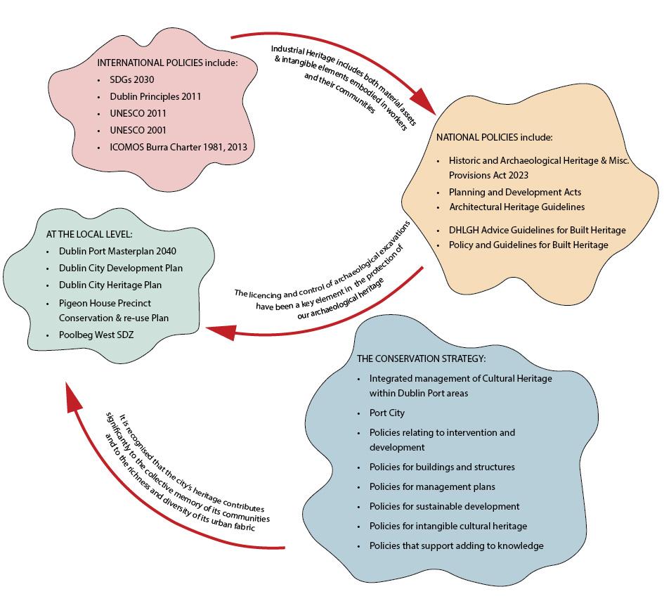
UNESCO - United Nations Educational, Scientific and Cultural Organization
UTM - Universal Transverse Mercator
3FM - Third and Final Masterplan
Foreword
My objective in dwelling so much upon the history of our profession has been to stimulate you to assist in making its future worthy of its past. John Purser Griffith, Port Engineer, 1887 1
Dublin Port's rich history is interwoven with extraordinary engineering feats that have profoundly shaped the development of Dublin city. This enduring legacy of innovation has bridged the past and the present, addressing longstanding challenges while providing a blueprint for future needs. While the core challenges endure, their significance has grown, leading to dynamic shifts in how we tackle these obstacles.
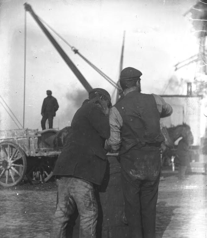
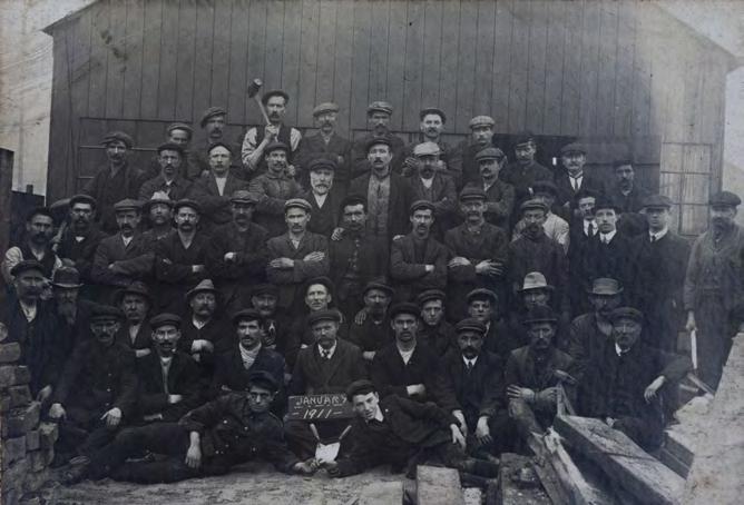
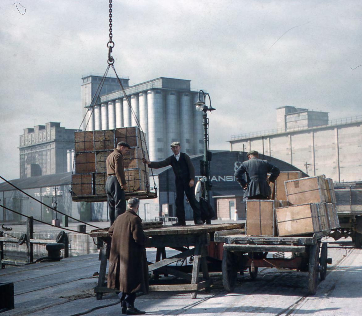
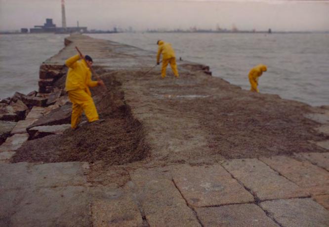
Once, Dublin Port was part and parcel of many Dubliners' identity. Ships, cargos, and dockers once flooded the city quays up to Essex Bridge. The port was one of the driving forces that expanded the city, extending its boundaries beyond the sea. Pioneering Port Engineers such as John Halpin and Bindon Blood Stoney, faced technical challenges with limited resources, while today's engineering teams benefit from financial strength and global expertise. However, they must also manage the environmental impact of modern development and preserve heritage within strict planning guidelines. Grand infrastructural visions were transformed into reality by the tireless efforts of generations of Dubliners, like those who ventured out in adverse weather to lay the foundations of the Great South Wall—an iconic city landmark enjoyed by all today. It resonates with the collective memory of dockers and workers, their hard work intricately woven into the fabric of the city's social history. Together, they have not only constructed physical structures but also forged a living bridge between Dublin's past and its flourishing future
This mandate serves as the cornerstone of the Dublin Port Masterplan 2040 —a comprehensive road map designed to support crucial projects aligning with sustainable development principles and positively impacting Dublin and its residents. Central to this effort is the objective of reconnecting Dublin Port with the city, exemplifying the masterplan's core values. Key objectives encompass re-establishing the Port's links with the city and its bay—an intricate mission rooted in heritage and the natural environment. In this context, the Port Heritage and Communications Department (PHC) emerges as a pivotal foundation. Arising directly from the Masterplan 2040 and statutory obligations outlined in the Harbours Act 1996, PHC embodies a strategic imperative of paramount importance: to reintegrate Dublin Port with the city to realise Dublin as a Port City once again.
Within the intricate interplay of urban life and port operations, PHC assumes a crucial role, safeguarding the past while paving the way for the future. As dedicated practitioners, PHC ensures that Dublin Port Company's (DPC) growth harmonizes with deep respect for the Port's heritage, infusing each project with meticulous historical research, thoughtful design, and meaningful community involvement. DPC has undertaken measures proactively to protect the Port's heritage legacy as stewards of what remains. In recognition of the significance of preserving the cultural and historical richness within the Port Estate, DPC initiated a comprehensive Conservation Strategy. This strategy forms the bedrock, safeguarding heritage assets within the Port Estate. Importantly, it aligns closely with the visionary goals outlined in Masterplan 2040 , underscoring DPC's commitment to seamlessly integrating heritage with capacity building. This integrated approach reflects DPC's renewed dedication to restoring historical bonds with Dublin City and fostering community enjoyment.
Moreover, the Port has commissioned a Flood Risk Assessment to address sea-level rise challenges, alongside a Tern Colony Management Plan catering to natural heritage interests around migratory birds. These initiatives reinforce DPC's dedication to the natural and built Environment, Heritage, and Port-City Integration in the sustainable development of the Port Estate for the future.
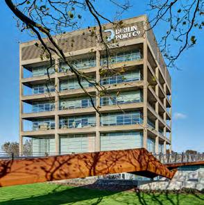
Barry O'Connell CEO
Dublin Port Company
Foreword Endnotes
1 John Purser Griffith (1848 to 1938) was an engineer with Dublin Port & Docks Board from 1871 to 1913. He worked alongside Bindon Blood Stoney for 27 years before replacing him as Chief Engineer in 1898. Purser Griffith retired in 1913 in frustration at what he perceived as the Board’s reluctance to continue with the development of deepwater berths in the Port. This quotation is taken from his Presidential Address to the Institution of Civil Engineers in 1887.
Executive Summary
Chapter 1
Introduction, discusses the purpose of the Dublin Port Heritage Conservation Strategy, which is to understand the significance of the Port’s heritage and promote Dublin Port Company’s (DPC) commitment to preserving, interpreting and making accessible its heritage assets in the context of its responsibilities for sustainable development of the Port towards a maximum capacity of 73.8 million tonnes per annum by 2040. DPC faces challenges of retaining its significance as a Deep Water Port and the plan recommends policies for interventions that are considered in relation to challenges of climate change and sustainability, in balance with environmental and heritage constraints.
Chapter 2
Understanding the context, summarises the Port’s development from earliest times and describes the current policy context with reference to statutory and non-statutory cultural heritage policy and to Dublin Port Masterplan ( Masterplan 2040) . It develops further detail on DPC’s policies in relation to current and future developments within the Port Estate. It considers the interdependency of cultural heritage and natural heritage, and includes an ownership statement that sets out certain differences between Port lands north and south of the River Liffey. The differences can be traced back to the circumstances in which the Port acquired lands and has ramifications for the management of the Port’s heritage.
Chapter 3
Assessment of significance, describes the many perspectives that are active across the maritime industrial cultural landscape, and considers intangible aspects as well as the tangible assets that exist as archaeological and built heritage features and structures above and below the waterline across the Port Estate.
Chapter 4
Threats to significance, considers the principal agents and factors that can impact on cultural heritage within the Port area, arising from land-use and from natural factors such as environmental change.
Chapter 5
Heritage and conservation management policies, develops principles for protecting and enhancing the elements of significance
and making them accessible to the public where possible, and sets out the following twelve policies:
1. Policy for integrated management of cultural heritage within the Dublin Port areas
2. Policies for protection of Dublin Port as a Cultural (Historic Urban; Maritime; Industrial) Landscape combined with Polici es of Port-City integration – The Port City concept
3. Policies relating to retention, recovery and use
4. Policies which support awareness of cultural heritage, improved access and engagement
5. Policies relating to intervention and development affecting significant cultural heritage
6. Polices for buildings and structures of heritage significance not protected by heritage legislation
7. Policies for works to buildings or structures which are of local or record only importance
8. Policies relating to management plans
9. Policies for sustainable development
10. Policies to address intangible cultural heritage of the Port
11. Policies that support adding to knowledge and record
12. Dublin Port Heritage and Communications Policy
The above policies can be considered recommended objectives when the heritage assets are not in Dublin Port Company ownership. These policies are in line with AIVP and ESPO Agenda 2030 to reinforce Port-City relations and strengthen DPC's commitment to heritage safeguarding while contributing to broader sustainability goals on a global scale.
Chapter 6
Implementation and review, sets out a possible means of implementing the Conservation Strategy and ensures that it is reviewed and remains current.
In conclusion, this strategy looks at the Port Estate, firstly as a discreet collection of cultural heritage and archaeological assets to be understood and protected; secondly as a heritage port landscape expressing Dublin City’s unique marine character; thirdly as a collection of extraordinary documentation, stories and memories to be protected, interpreted and remembered; fourthly, as a story of innovation and engineering excellence of international significance and, finally, as an ancient connection with water at the centre of Dublin City’s identity and an expression of Irish national pride.
Introduction
• Background and Purpose
• Vision
1.1 Background and Purpose
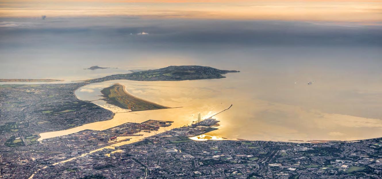
The Dublin Port Estate is best described as a maritime industrial cultural landscape that retains a complex interaction of community and heritage alongside the operational activities that are associated with being Ireland’s principal port. It is a rich tapestry of intensive land use that takes place across a large swathe of the River Liffey’s estuary, with Special Areas of Conservation to its north and south, and with cultural heritage structures and features dotted across its footprint above and below the waterline.
Dublin Port Company’s commitment to acknowledging its responsibilities to its cultural heritage assets is set out in the Dublin Port Masterplan 2040 , which includes as one of its strategic objectives ‘the preservation of all Protected Structures within the Port Estate’ 1 The 2018 review of the Masterplan strengthened this awareness by including the strategic objective to ‘integrate new development with the built and natural landscapes of the surrounding area’. 2
The review also committed to carrying out project specific heritage and leisure assessments of proposals for individual development projects brought forward under the Masterplan. 3 The objective aims to avoid loss of or damage to heritage features and where possible, to incorporate heritage features into the Port Estate, with particular regard to local maritime and industrial heritage.4
The present document builds on these objectives. It takes the opportunity to present a history of the Port’s development from earliest origins upriver at Wood Quay, to the present location that has been developed progressively since the eighteenth century, as the city and its port responded to the ever-growing needs of the burgeoning economy across Ireland. In developing a Conservation Strategy (Conservation Strategy) for the Port Estate, the Port does so
within the context of statutory commitments to safeguard heritage assets, and at a time when we are keenly aware of pressures from climate change, as well as from development.
The Conservation Strategy will advance a series of policies that the Port will champion, and it will provide a clear road map for the implementation and review of the Conservation Strategy. In doing so, the document sits comfortably alongside exemplars of international best practice and represents an important milestone achievement in Ireland’s developing awareness of maritime and industrial heritage.
1.2 Vision–Maintaining the Cultural Significance of Dublin’s Deep Water Port
Seminal and innovative engineering has enabled the creation of a deep water channel and berthing in Dublin Port. As with all ports, Dublin’s development has tracked the changes in shipping and its phased expansion has followed advancements in shipping. It has been noted that a port’s survival depends on its ability to adapt to changes in shipping technology. It is the shipping perhaps more than the transported cargo that leads to changes in port infrastructure.
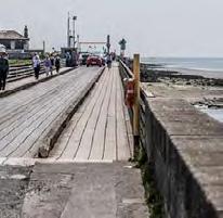
The requirement to facilitate the future expansion of Dublin Port respects its cultural significance as a deep water port. In the past, its development has required exceptional engineering techniques on the north side of the Port and in particular the expertise of Bindon Blood Stoney, John Purser Griffith and Joseph Mallagh. 5 On the south side of the Port, the Great South Wall constructed between 1716 and the 1790s was the longest breakwater of its type in the world. It is extraordinary that it still stands substantially in its original form to protect the channel to Dublin Port, allowing the safe passage of commercial shipping that is estimated to account for at least 60% of Ireland’s imports.
Dublin Port Company is mindful that the image and experience of Dublin City has been significantly shaped by its antecedent bodies, and particularly by their engineers, whose remits were extensive. The development of port-related land uses inevitability contributed to the iconography of the City.
Blood Stoney was responsible for the design of the bridge that replaced Essex Bridge (1750), renamed Grattan Bridge, in 1872/73. He was also responsible, in 1877/80, for the design of Carlisle Bridge (now O’Connell Bridge) which replaced an earlier bridge designed by James Gandon.
In 1877/79, he designed Ireland's first swivel bridge – Beresford Bridge – later to be renamed Butt Bridge. It was short-lived (51 years) and was replaced in 1932 by Ireland’s first reinforced concrete bridge, designed by the Port and Docks Board’s chief engineer, Joseph Mallagh.
The overlay of the regenerated Docklands has seen the substantial conservation and integration of vestiges of the Port’s ‘Georgian’ epoch, notably the Custom House Docks and Grand Canal Basin.
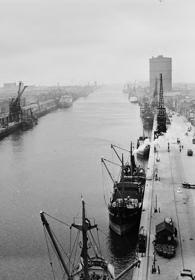
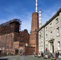
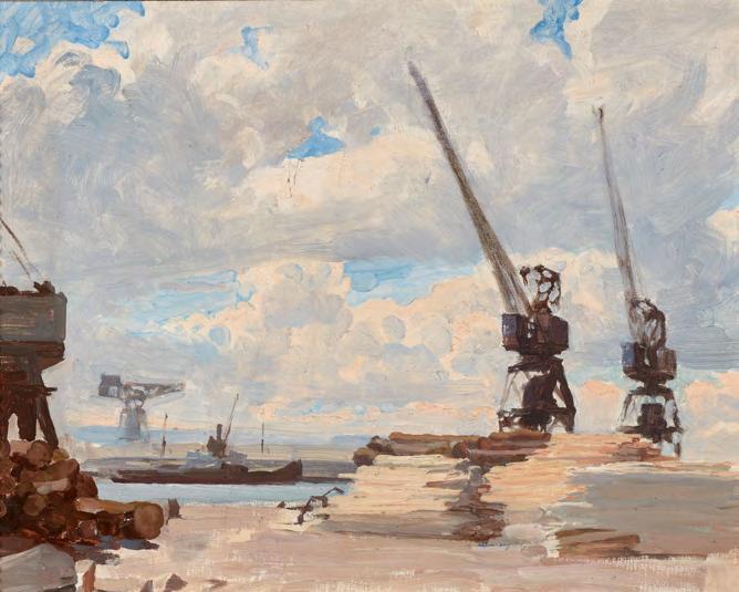
Other structures evolved on the former Dublin Port and Docks Board area, such as the now demolished landmark Gasometer, which was for generations a symbol of Dublin.
Structures on or adjacent to historically Port related lands continue to evolve in Dublin’s iconography. The National Convention Centre stands at the junction of the Royal Canal and the Liffey a t Spencer Dock. Immediately south of it is Santiago Calatrava’s Samuel Beckett Bridge.
Together, they offer a set piece that is increasingly invoked as a symbol of contemporary Dublin in television broadcasting, nationally and internationally.
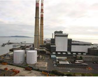
The ‘Poolbeg Chimneys’ in turn were, at the time of their construction, seen as blots on the coastline. Today they have become iconic to Dublin, and appear prolifically on tourist-oriented posters and prints.
In short, Dublin Port, and its related land uses, buildings and infrastructure, has been, is and will be central to the image, experience and culture of Ireland’s capital city.
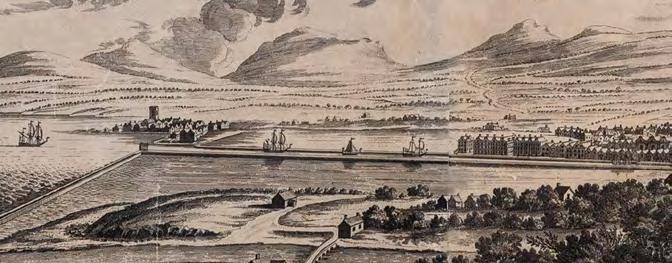
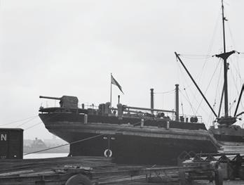
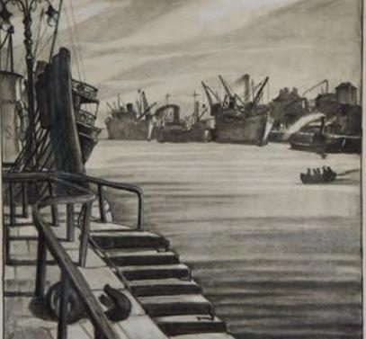
Historic view along the Quays looking east, with the Gasometer in the distance
Source: Dublin Port Archive
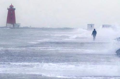
Today’s port managers face not only the technical and environmental challenges of a complicated port, but also the ever-expanding size, depth and turning requirements for both commercial shipping and cruise liners. Added to this are the effects of global warming and rising tide levels that pose a threat after the Port is developed to full capacity by 2040, and the desire to manage the natural and cultural heritage of the Port Estate in a responsible and meaningful way.
In order to preserve the cultural significance of Dublin’s deepwater port, changes and development are required that respect the significance of past achievements. According to Article 1.2 of the ICOMOS Burra Charter, cultural significance means aesthetic, historic, scientific, social, or spiritual value for past, present, or future generations. 6
There is also an appreciation within Dublin Port Company that the Port has a long history which has generated a rich resource of cultural, archaeological, industrial and maritime heritage, the significance of which is acknowledged within the Conservation Strategy.
Against this background, Dublin Port Company has adopted policies described in the Conservation Strategy to ensure that in
re-engineering a substantial amount of old infrastructure, the cultural, archaeological, industrial and maritime heritage of what is being redeveloped is respected and preserved appropriately and consistent with the need to expand the capacity of the Port.
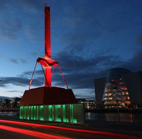
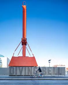
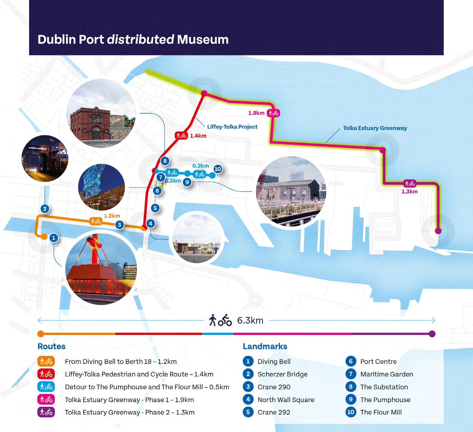
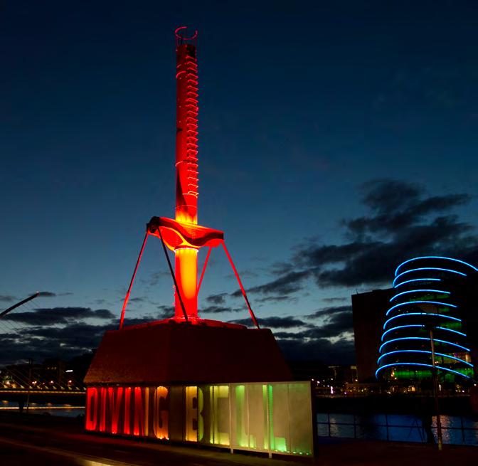
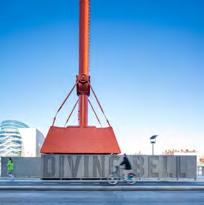
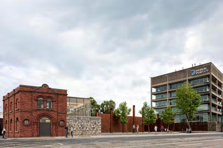
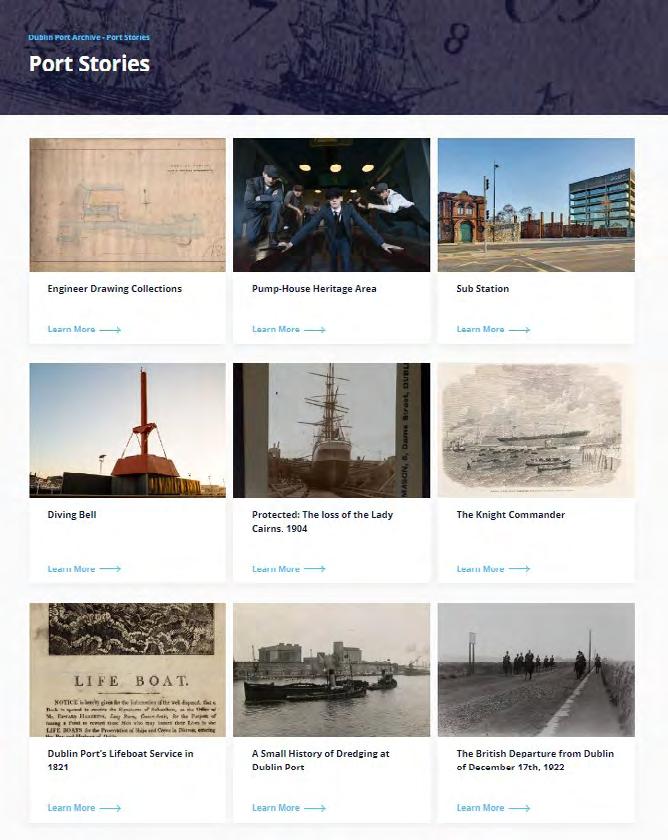
Dublin Port Company has also adopted policies that ensure the care of heritage assets outside the development zones to ensure that structures which are not under development scrutiny are properly cared for. There are multiple stakeholders operating within the Port and its immediate land areas. The Conservation Strategy presents policies that facilitate a cooperative approach among such parties to ensure care of heritage assets across the wider port area. The Port is pursuing a number of initiatives to promote awareness and public engagement with the physical elements of Port heritage. These have been grouped under the concept of the Distributed Museum and include the Dublin Port Diving Bell, the reconfigured and publically accessible Dublin Port Centre Precinct, the Pumphouse, the Substation, the Liffey Tolka Project, the Flour Mill Project and the Tolka Estuary Greenway, all described in Section 2.4.
This Conservation Strategy also introduces the Port City, which offers itself as a framework within which heritage assets across DPC’s estate can be accessed safely by the public, while recognising
Source: Dublin Port Archive
that the geography, history, heritage and ecologies of the Port are shared with other landholders, policy makers and stakeholders. The Port City concept is also described in Section 2.4.
Chapter 1 Endnotes
1 Dublin Port Company Masterplan 2012-2040 , p. 15.
2 Dublin Port Masterplan 2040 , reviewed 2018, p. 17.
3 Ibid, p. 70.
4 Ibid, p. 100.
5 Bindon Blood Stoney worked from 1856 to 1898 and developed extraordinary construction techniques using 350-tonne pre-cast concrete foundations on North Wall Quay Extension, Eastern break water (Tolka Quay), Alexandra Wharf and the North Bull Lighthouse. John Purser Griffith worked from 1871 to 1913, and was responsible for the continuation of Stoney’s deep-water facilities. Joseph Mallagh from 1917 to 1941 developed construction using concrete caissons in Crossberth Quay and Alexandra Quay West (Ronald Cox, Dublin Port Chief Engineers, (Dublin Port Company and Engineers Ireland, 2023)).
6 Australia ICOMOS, The Burra Charter: The Australia ICOMOS Charter for Places of Cultural Significance, 2013. http:// openarchive.icomos.org/id/eprint/2145/1/ICOMOS-Australia-TheBurra-Charter-2013.pdf.
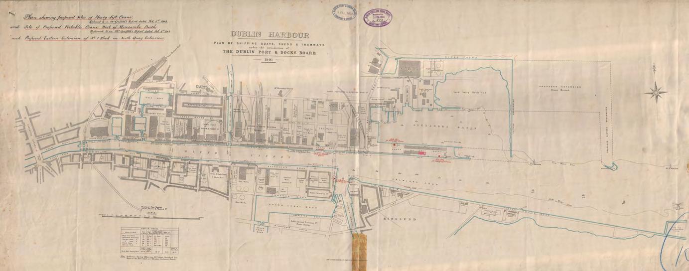
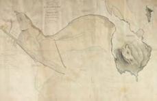
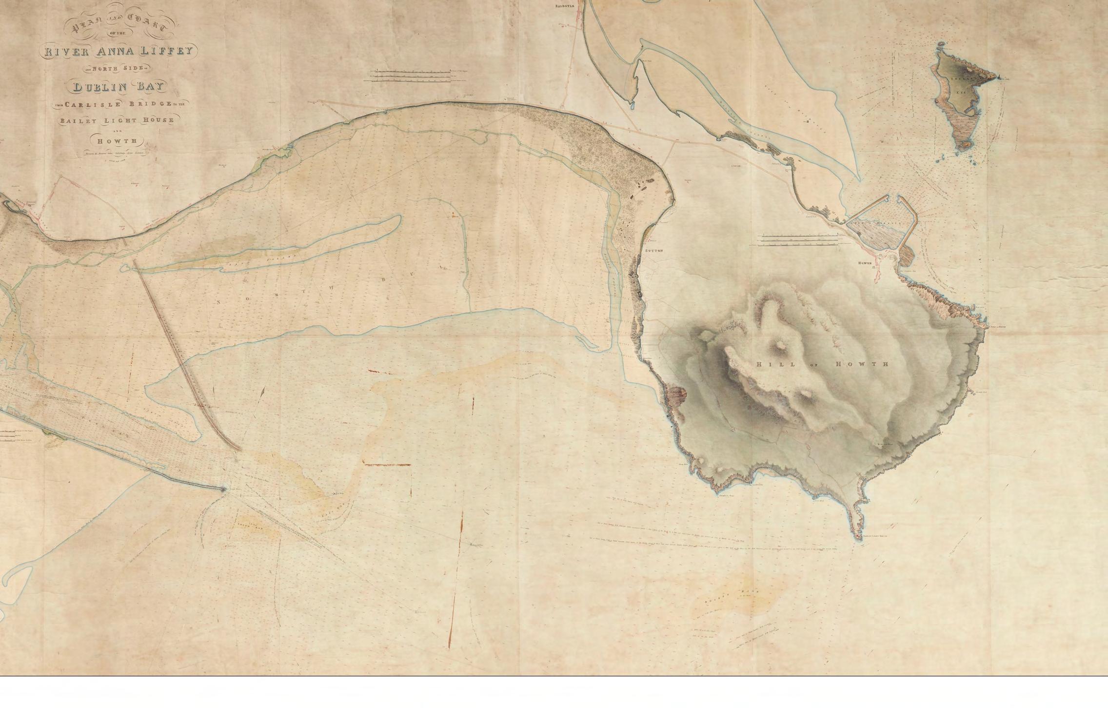
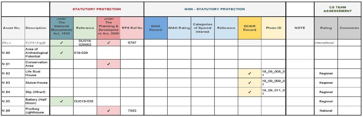
Dublin Harbour, Plan of Shipping Quays, Sheds and Tramways, 1901
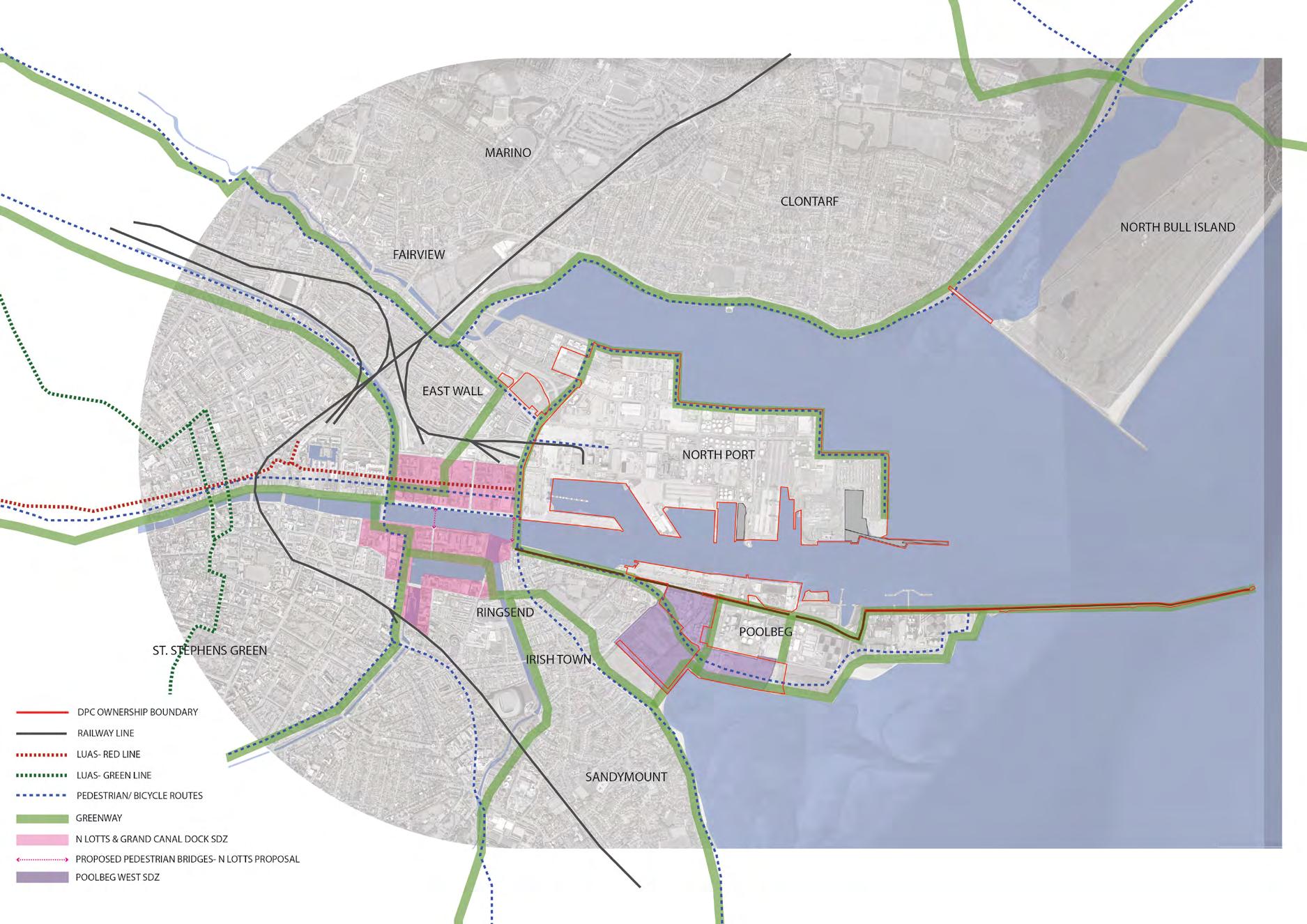
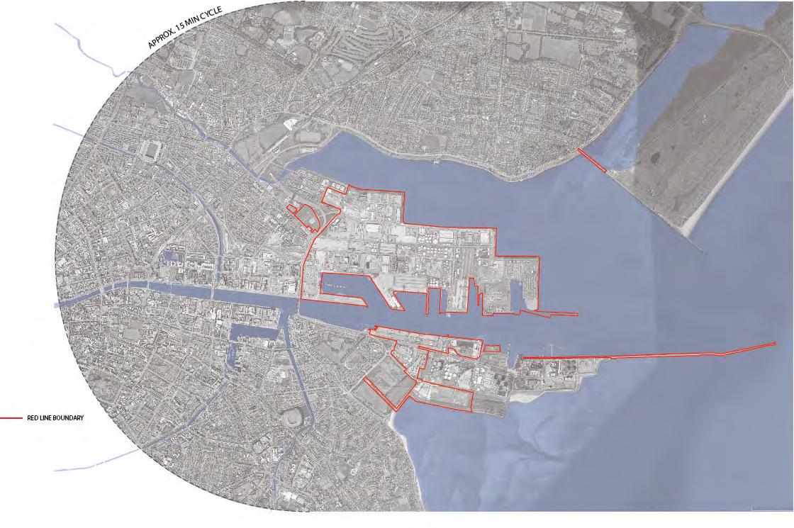
Conservation Strategy Study Area
This map identifies the area of focus of the Conservation Strategy in particular with regard to the Policies set out in Chapter 5. The map identifies the area in Dublin Port Company ownership and extends beyond this to include areas under separate ownership and management.
Dublin Port Company (Current Estate)
Dublin Port Company (current estate)
CMP Study Area Conservation Strategy Study Area
2.0
Understanding the Context
• Scope of Study
• Sources
• Historical Development of the Port
• Current Context
• Cultural Heritage Policy Context
• Masterplan and Rising Tides
• Cultural Heritage and Natural Heritage
• Ownership Statement
Opening of Alexandra Basin
Source: Dublin Port Archive
2.1 Scope of Study
The Conservation Strategy is used to define long-term heritage proposals and interaction with the public, heritage policies and management, and is intended for outside observers to see a longterm Heritage Plan within the Port Estate.
In a similar way to the principles advocated by ICOMOS, the International Council on Monuments and Sites for Conservation Management Plans, this Conservation Strategy is designed to explain constraints and issues that will arise in the future, and set out standards, protocols and managed procedures to mitigate what is otherwise a constraint when approached on a case-by-case or piecemeal basis. This Conservation Strategy is a ‘live’ document based on a strong foundation of empirical data relating to the project area and subject to periodic review and updating as regulations and guidelines develop and as new opportunities present themselves.
This Conservation Strategy for Dublin Port recognises the complexity of this landscape and incorporates insights from a wide spectrum of core Port interests and disciplines, including but not limited to:
• Port Heritage and Communications
• Port Engineer
• Port Estates and Facilities
• Port Harbour Master
• Port environmental consultants
• Port cultural heritage consultants
• Port community groups (residential, recreational, business) via Dublin Port Company
• Regulators (including Dublin City Council, National Monuments Service, National Parks and Wildlife)
The RPS team with responsibility for the Conservation Strategy is led by Dr Alan Barr, Senior Director of RPS Group, reporting to the Port Heritage and Communications Department and the Port Engineer. The team’s sub-disciplines include:
• Archaeology, led by Dr Niall Brady, Director of the Archaeological Diving Company (ADCO) Ltd
• Conservation Engineering, led by Christopher Southgate, Director of Southgate Associates
• Conservation Architecture, led by Gráinne Shaffrey, Director of Shaffrey Architects
• Heritage Gain initiatives/Compensatory, led by Seán Ó Laoire, Consulting Director, Kieran Fitzgerald, Associate, and Maliha Rafique, Architect of MOLA Architecture
• Coastal Processes, led by Adrian Bell of RPS
The team has extensive experience of Dublin Port, with the RPS members, ADCO, Southgate Associates and MOLA playing key roles in preparing the EIS and EIAR that were delivered successfully for the ABR Project and MP2 Project respectively. RPS and ADCO are also active participants in the construction phase of the ABR Project, and ADCO has served as the Port’s Project Archaeologist since 2015. Shaffrey Architects are currently working on the Odlums’ Flour Mill project and the Liffey-Tolka project.
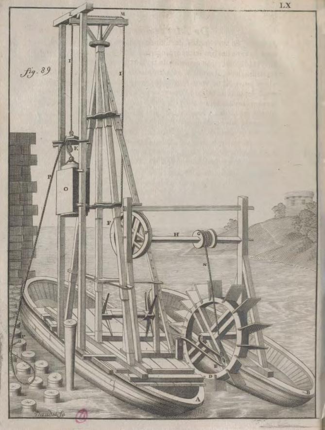
Source: Recueil d'ouvrages curieux de mathématique et de mécanique, ou Description du cabinet de M. Grollier de Servière, avec des figures en taille-douce, par M. Grollier de Servière, 1733. Fig. 89, plate LX BnF_2013-76536
Scope
This Conservation Strategy is a high-level document that sets out its purpose and scope within the context of Masterplan 2040. It identifies and develops the Port’s vision for cultural heritage within the Port Estate and the relationship between Port and City.
It describes the principal issues in terms of significance, pressures or threats on the Port, and policy issues and legal status.
The Port Estate is approached as a Maritime Industrial Cultural Landscape. It is both the sum of its parts and the focus of individual detail.
The Conservation Strategy presents a narrative of the history of the Port, considering the historical context and the development of the Port’s footprint. It draws on existing registers of features, the Port’s archives, publications and grey literature (i.e. unpublished studies and reports), as well as current work during the ABR Project and harbour maintenance works, to demonstrate and show the nature of the record and the vulnerabilities that exist on land and at sea, above the ground and underwater.
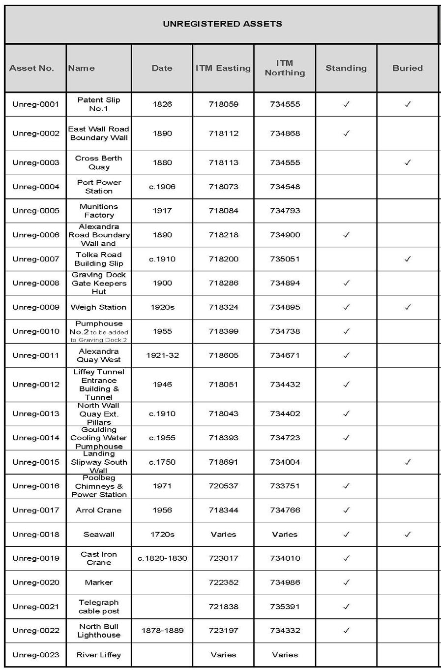
There are key heritage features that are well known and clearly visible, but there are also many less well-known features and locations/settings that need to be referenced. The Conservation Strategy refers to an audit of the Port’s and associated land-owner’s heritage assets that are standing and those that are buried, much of which can be collated from existing records and studies, as introduced in Chapter 3.2.
Vulnerabilities exist from development projects within the Port and from those associated with the Port lands. Vulnerabilities also exist from natural processes, and the concurrent research into coastal processes and sea-level rise being carried out by RPS on behalf of the Port plays a key role that has a direct bearing on the consideration of the Great South Wall and the North Bull Wall within the context of the Conservation Strategy and the future integrity of the Port area.
The Conservation Strategy highlights existing and future opportunities for heritage gain and compensatory measures, in terms of setting, in terms of the preservation of standing remains where possible, and in terms of new design initiatives and concepts. The engagement with the public in terms of visitor facilities and
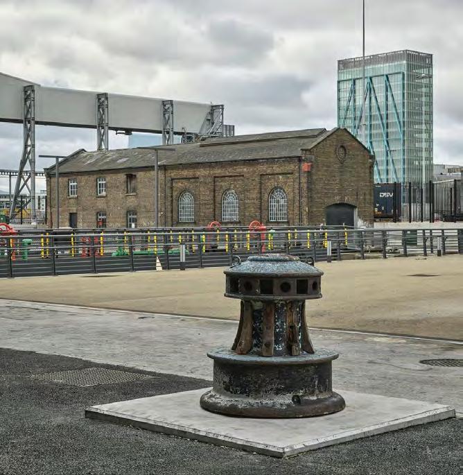
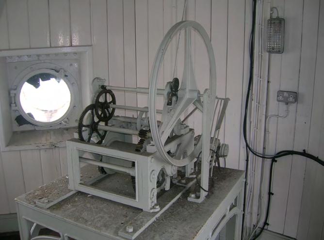
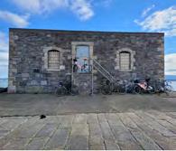
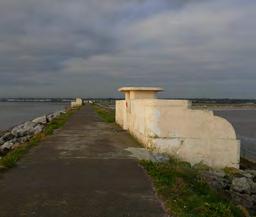
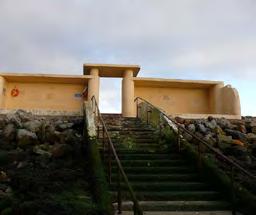
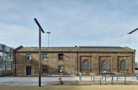
The Substation
The Graving Docks
Port Precinct Time Ball
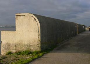
The Great South Wall
space, events, recreation, education, interpretation and public safety are key issues. In view of the high demand for land for Port use within a comparatively small and intensely used space, clear and robust policies are recommended for preserving and enhancing the setting of certain heritage assets, and these policies are introduced under the heading The Port City.
The management of heritage within the context of the Conservation Strategy will address implementation, which includes decisionmaking, resources, finance, communications, research, objectives and opportunities, in the short-to-medium-to-long terms, as well as monitoring and reviews.
Method
The project team has held a series of workshops and field trips that have included Dublin Port Company and the principal stakeholders within Dublin City Council, the National Monuments Service and the National Museum of Ireland. The workshops have presented the opportunity to agree the scope and inputs, to understand further the constraints and to report the findings and outputs.
Communication has been key to the successful delivery of the Conservation Strategy and the project team has met regularly over a twelve-month period at fortnightly meetings. A series of wider community engagements are planned and the observations and findings from these will be added to the Conservation Strategy as appendices.
Outputs
The Conservation Strategy is a high-level over-arching document that will inform the cultural heritage risks and requirements for the successful delivery of the Port’s future planning needs.
Emphasis is placed on conveying the substance of the Conservation Strategy visually through a set of well-designed maps and selected illustrations that convey the message of the Conservation Strategy to specialist, engineer, and interested person alike.
Key maps and illustrated sequences illuminate:
• An understanding of the site and its significance
• Ownership
• Environmental issues
• Development proposals
• Vulnerabilities
• Opportunities for heritage gain and public access
The Conservation Strategy combines text and image to deliver a landmark study in Ireland that will inform Dublin Port Company’s vision and apparatus for managing, protecting and showcasing its cultural heritage assets for the next decade and in line with Masterplan 2040.
Sources
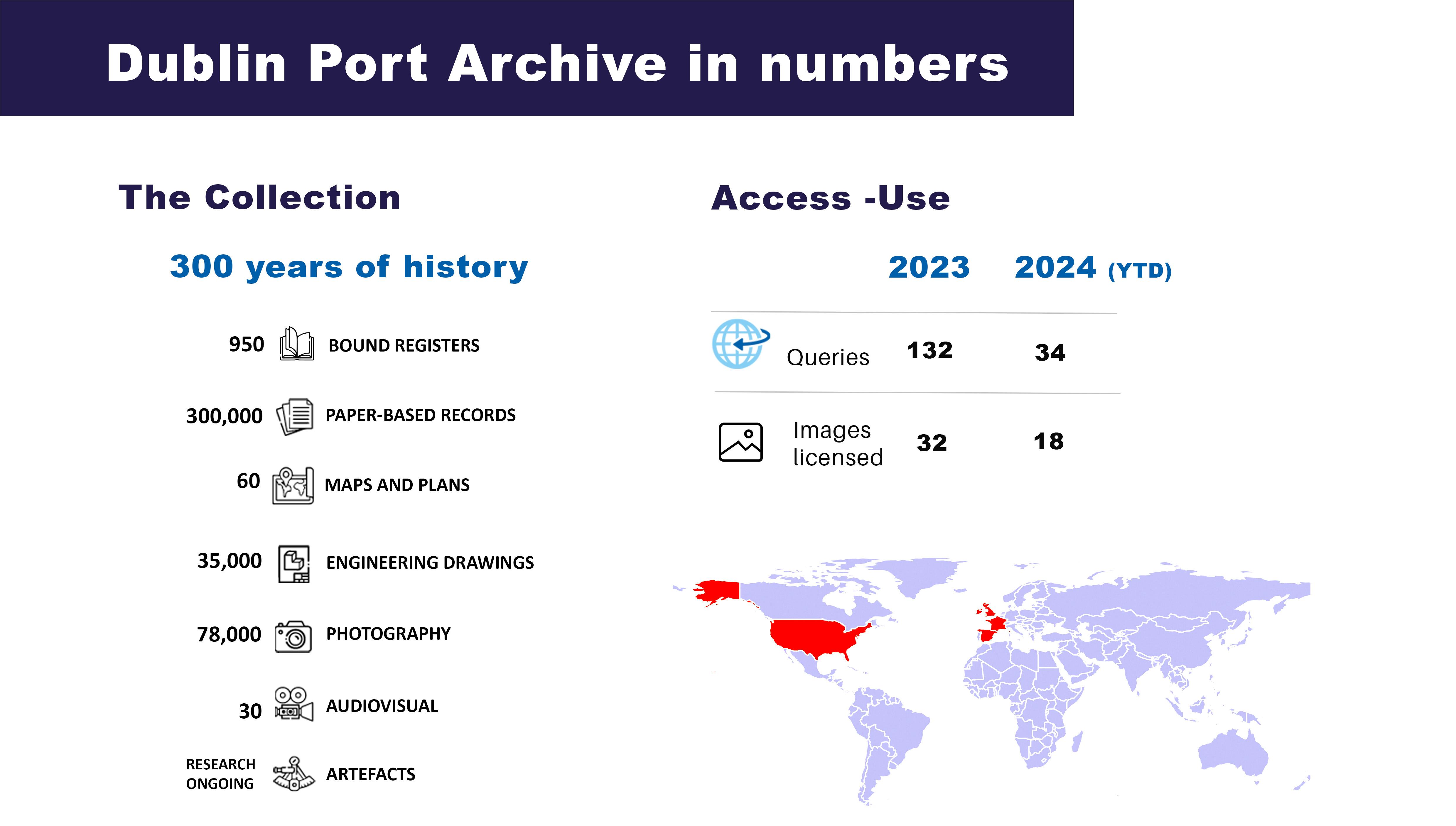
A wide variety of primary sources exist to inform the history and development of Dublin Port. In addition to the standing remains, many of which are recorded in the statutory and non-statutory heritage registers, there are innumerable historic map series, sea charts and engineering drawings, along with historic photographs, paintings, illustrations, audio and multimedia files that illustrate and comment on aspects of the landscape, the activities, the interventions and the sensitivities that intermingle across it. A considerable amount of this material is catalogued and known about, but new elements will continue to be revealed and it is clear that the size of the corpus is beyond finite. Dublin Port Company’s own archives, which extend back to the early 1700s, are a remarkable resource of knowledge about the Port and remain indispensable to its management.
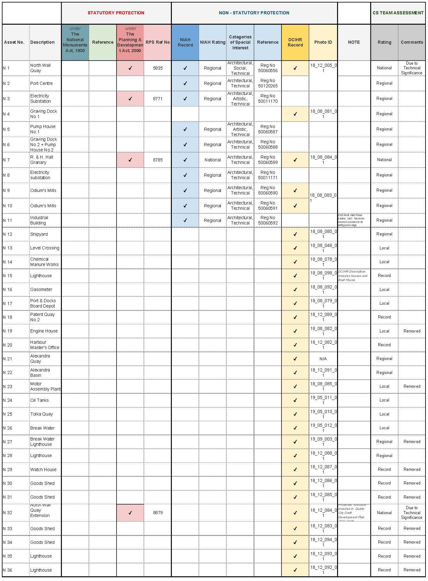
The physical remains of the historic port and its associated activities present a first step in any study of its cultural remains. Yet because many of the standing remains date from the late eighteenth century and more recently, they are not necessarily recorded in the Sites and Monuments Record (SMR) and the associated Record of Monuments and Places (RMP) maintained by the National Monuments Service (NMS) of the Department of Housing, Local Government and Heritage (DHLGH), whose focus is on archaeological sites and features that pre-date c. 1750. A counterpoint to this is the National Inventory of Architectural Heritage (NIAH) maintained by the Built Heritage Policy unit of the same Department, which seeks to record sites and features of architectural heritage interest. However, not all cultural heritage features are of architectural interest and to ensure that such elements are recorded, Dublin City Council has established the Dublin City Industrial Heritage Record (DCIHR). In addition, the NMS has created the Historic Shipwreck Inventory for
sites that exist under water and any wreck older than 100 years is automatically a protected site in accordance with the National Monuments Act, which is being superseded by the Historic and Archaeological Heritage and Miscellaneous Provisions Act (2023). The NMS also has a Ports and Harbours inventory that can contain useful observations, while the National Museum of Ireland is the national repository for artefacts.
The features and sites that are recorded within the Port Estate on these registers are summarised in the sequence of maps and tables presented in Chapter 3.2, and are referred to as needed throughout the Conservation Strategy. It is the case that not all the heritage features that exist within the Port area are recorded on the existing registers, and it is necessary to anticipate that new features will continue to be identified. Consequently the Port is providing a supporting heritage register of such observations and a list of some of these items identified to date is presented in Chapter 3.2.11.
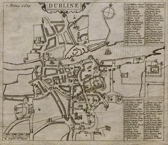
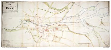
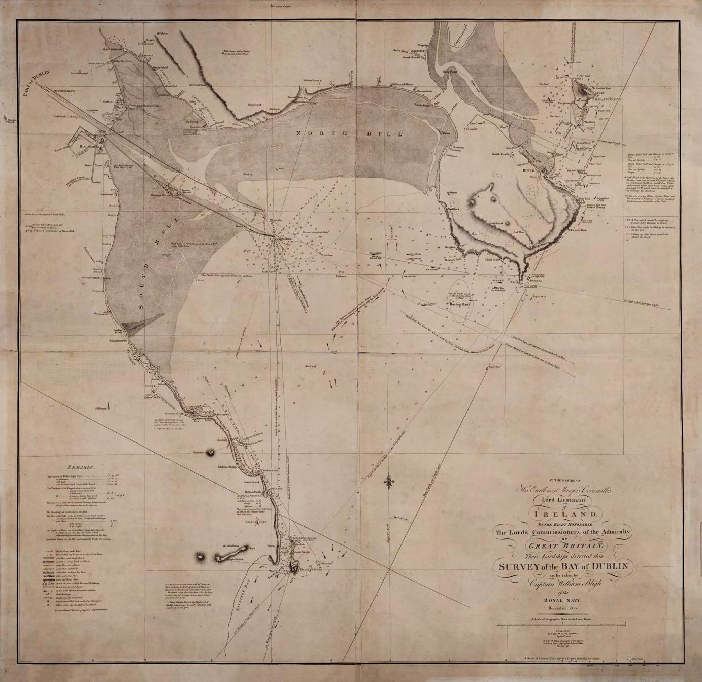
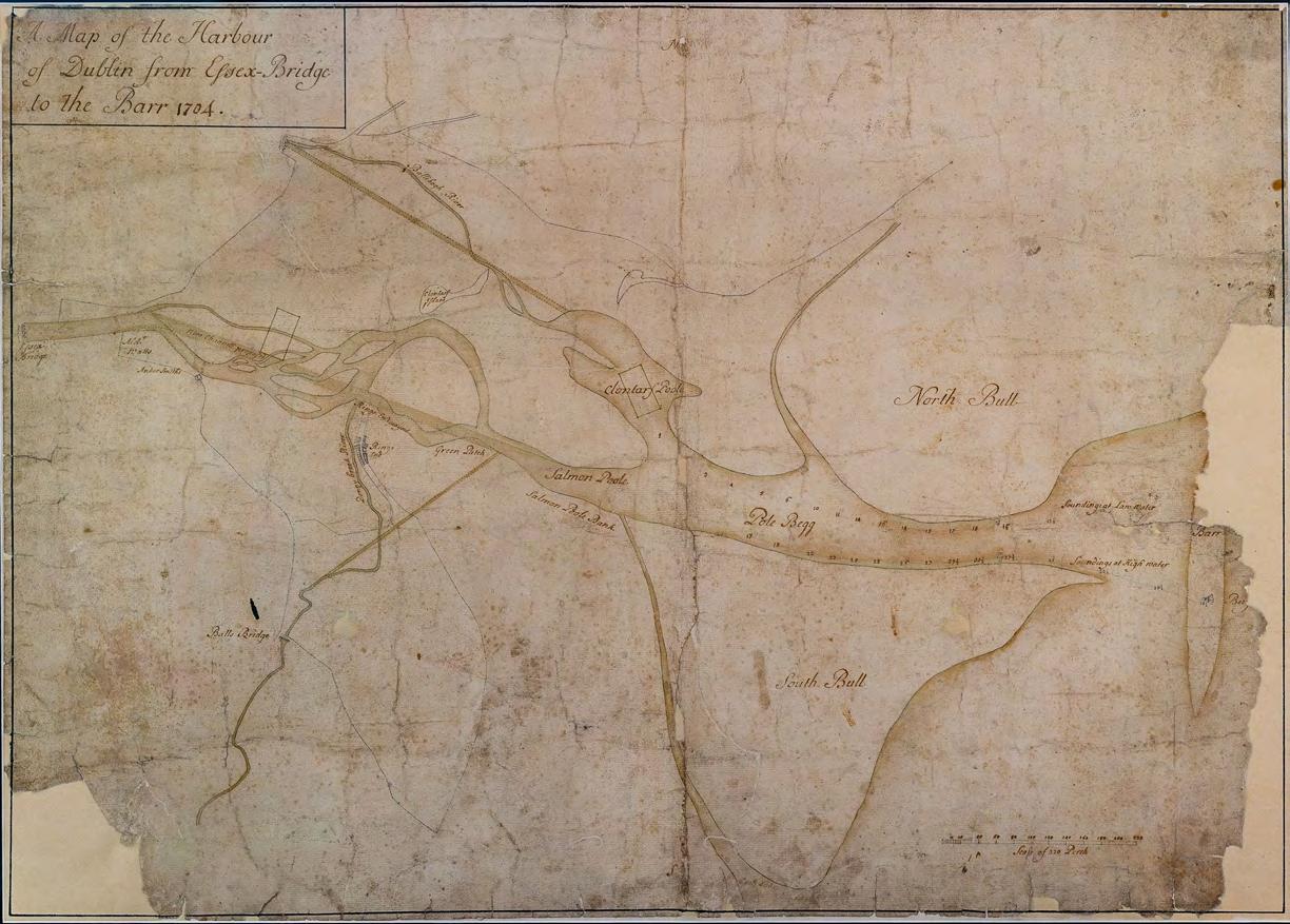
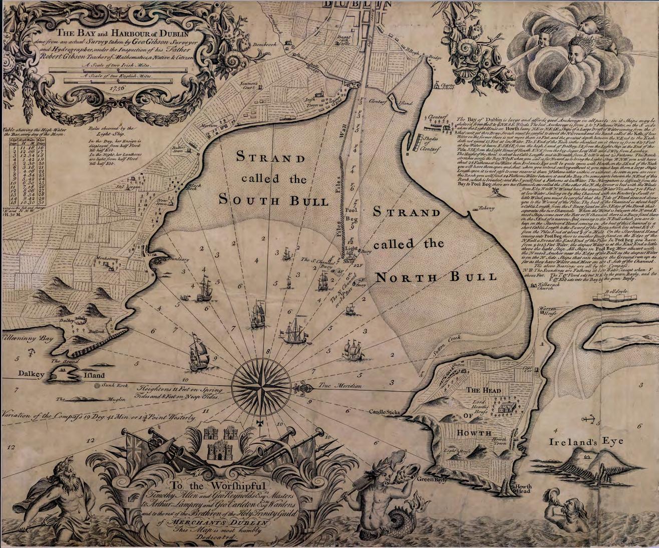
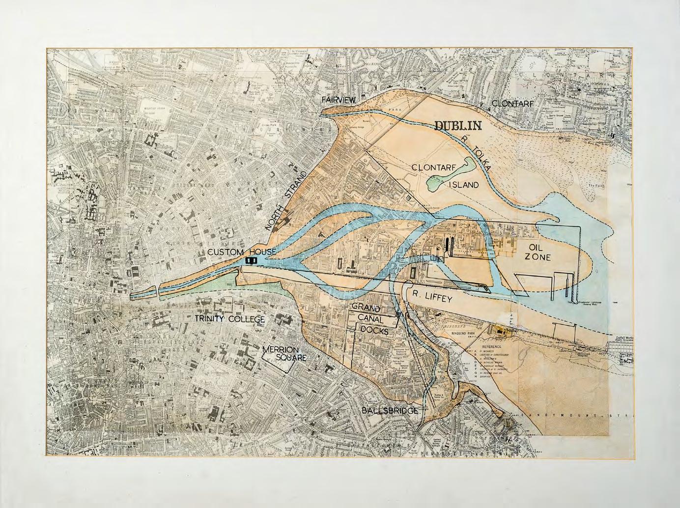
As Ireland’s capital city and principal port, Dublin attracted a series of cartographers and hydrographers since it became commonplace to map places. One of the earliest useful maps of Dublin is John Speed’s map of 1610, which shows the small medieval town focused upriver at Wood Quay and Christchurch, and its working quayside. 1 As Dublin expanded eastwards, so the mapping extended downriver, and Bernard de Gomme’s map of ‘The City and Suburbs of Dublin’ (1673) includes a strong focus on the deltine estuary, reflecting the keen interest of that time to start manipulating the river channel to facilitate shipping and expand the city seaward. As with many historic maps and charts, de Gomme’s map included factually accurate records of streets and places, as well as aspirations that were never realised, such as the proposal to construct a star-
John Speed's Map of Dublin, 1610
Source: Dublin Port Archive
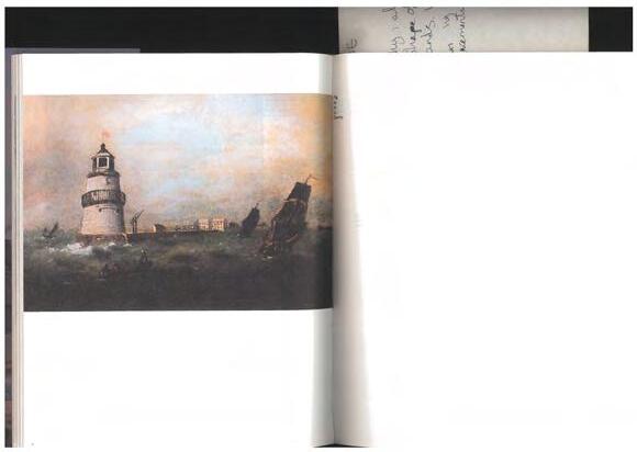
Poolbeg Light House. Proposed plan for protecting the base of the tower, detail of. Bindon Blood Stoney engineering drawing, 1861
Source: Dublin Port Archive, ref 8437
shaped fort at Ringsend that was to straddle the confluence of the River Dodder with the Liffey. Confident large-scale civil and marine engineering projects are a feature of the eighteenth and nineteenth centuries, as well as more recent times, and the historic maps of Dublin and its port area reflect these well.
The Ordnance Survey’s map series that commenced in the mid1800s provide the baseline metrically-accurate maps for Ireland and are accessible online. In addition to their regular coverage of the Port area at 6-inch to the mile and 25-inch to the mile historic map series, the Ordnance Survey maps also informed larger-scale mapping programmes that include the Port area (which are not available online), such as the Dublin City map series of 1847 at 1-inch to 88 feet, and Griffith’s Valuation Maps of 1909 at 5-feet to the mile; these maps bring the reader much closer to the detail at street level and permit the recording of small items such as boundary walls, gate posts, service ducts and other less obvious features. The surviving maps may also include annotations or notes added to the base map by various individuals who used them over the years, adding potentially important insight to how streetscapes changed over time.
The National Library of Ireland, the National Archives and the Dublin City Archives retain many of the primary historical sources that inform a study of the Port area and its development. So too does Dublin Port Company, whose archives are currently the focus of a long-term programme of cataloguing and preservation. The archives include engineering drawings, photographs, testimonials and port board records that illuminate the history of the Port, its staff and its operational history since the 1700s.2
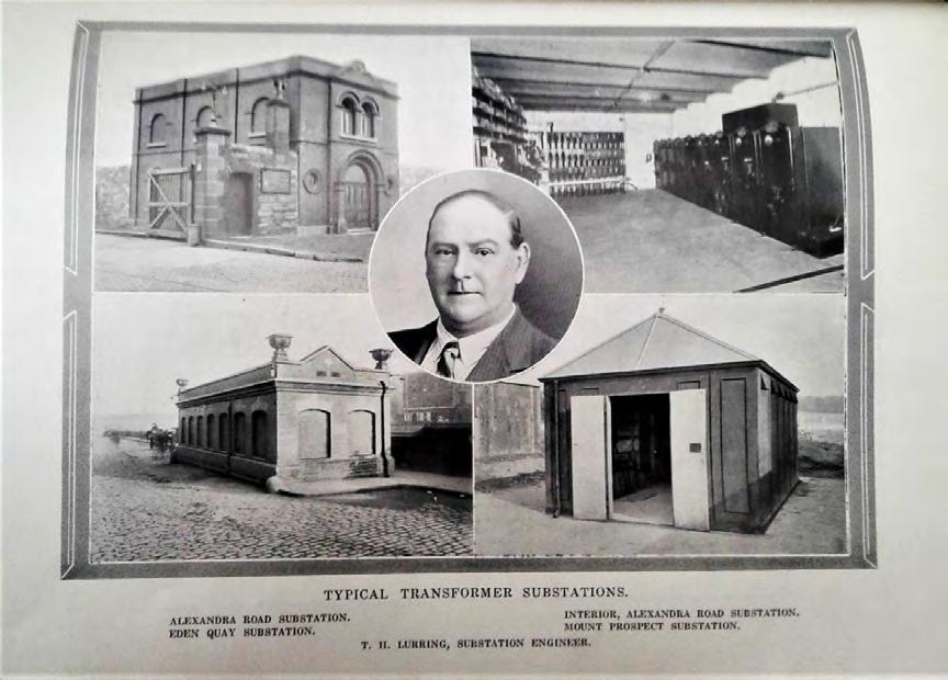
One can anticipate that other stakeholders within the Port area will have their own archives of documents and images that are worth consulting. While the ESB may be the principal such stakeholder (its utilities operations include large tracts of the south port area with substations and cabling across the north port area as well), there is every likelihood that smaller operators, the boat clubs and indeed individuals will have their own historic records that can lend insight.
The primary sources have helped to inform a series of comprehensive studies of the Port, and two such books deserve special mention because they are based on a deep knowledge and comprehensive understanding of the sources:
• H.A. Gilligan, A History of the Port of Dublin (Gill and Macmillan, Dublin, 1988). Gilligan worked at the Port for over forty years and served as secretary to the Board for seven years. His is a study of the governance of the Port and its interactions with Dublin Corporation.
• J. W. DeCourcy, The Liffey in Dublin (Gill and MacMillan, Dublin, 1996). John DeCourcy was Professor of Engineering at University College Dublin and his book presents an encyclopaedic style account of the Liffey’s history based on placenames and key personnel, arranged A–Z.
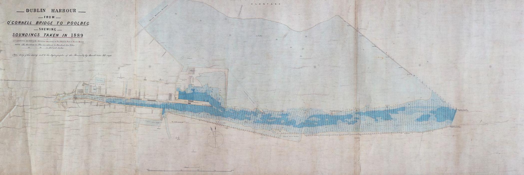
Dublin Harbour from O'Connell Bridge to Poolbeg Shewing Soundings taken in 1889, by JP Griffith
2.3 Historical Development of the Port
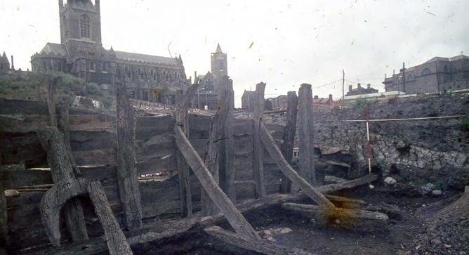
As the country’s principal port and capital city since the Middle Ages, the story of the Port’s development is well known and referenced. 3 Its early origins were revealed upriver at Wood Quay, when construction of the future Civic Offices complex uncovered elements of the Hiberno-Norse town and quayside.
The River Liffey offered access to the emerging town, and its wide and shallow course suited shipping in these centuries but shipping changed over time, becoming more deeply drafted and unsuited to the shallow waters within the river channel and the deltine nature of the estuary. By the fifteenth century, the situation was such that the larger and heavier craft would have to use deep-water harbours around Dublin Bay as they were unable to bring their vessels directly to the city. It accounts for why Dalkey would become an important entity at this time, hosting seven fortified merchant’s castles, along with Lambay, Clontarf and other small anchorages around the bay. 4 The city fathers were keen to retain authority, however, and required that all merchandise landed at the satellite harbours was to be transported overland into Dublin before it could be sold.
It was not until the seventeenth century that the city addressed the challenge by actively engineering solutions to encourage shipping back to the city. What began as small-scale local attempts to embank the river were elevated to a more coordinated approach with the establishment of the Ballast Board in 1707 to initiate engineering and reclamation works along the Liffey. The board was established by an act of Parliament and was a committee of Dublin Corporation, which administered the Port of Dublin until 1786, at which point it was replaced by a new port administration that was independent of the Corporation. Although the new entity continued to be known as the Ballast Board, it was the Corporation for Preserving and
Improving the Port of Dublin, which continued until 1867 when it was replaced by the Dublin Port and Docks Board. Dublin Port Company has managed the port since 1997.
City Quays
The quays that present themselves today as a uniform suite of cut granite blocks belong to the nineteenth century but have their origins in the early 1700s, when embankments were constructed downstream of Essex Bridge to the mouth of the Dodder on the south side and to the east wall on the north side. The embankments served to create a single channel for the river and were completed by 1728. They also facilitated the reclamation of lands to the north and south; namely, the North Lotts and the South Lotts respectively.
The Ballast Board upgraded the quays west of O’Connell Bridge, while those downstream to Ringsend would be deepened and further improved to accommodate steam ships. The construction of large enclosed docks on both sides of the river would become industrialised zones. 5
East Wall Road polder
Reclamation of the North Lotts began in the early eighteenth century. The term ‘Lott’ derives from the manner in which the various properties within the reclamation area were distributed, which was done by casting lots. A survey carried out in 1715 was directed at dividing the ground into lots to rent to the chief officers of the city. There were acre lots, which covered much of the area, and foot lots which were smaller parcels that abutted what would become North Wall Quay.
Wood Quay excavations showing river-front Source: National Museum of Ireland
Charles Brooking, Dublin, 1728, detail of Source: Dublin Port Archive
Ceremonial Silver Trowel used in 1817 to lay the foundation stone of George's Dock. Source: Dublin Port Archive
One proposal was for the reclamation to extend all the way to Clontarf’s north strand, and it would be built and maintained by the funds raised by the allottees. A map of 1717 sets out the aspirations, but the full plan was not realised and only the southern element was developed.
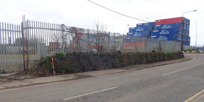
A massive sea wall was constructed in the late 1720s to permit reclamation within the large swathe of former sand flats. The sea wall lends its name to East Wall Road, and ran north from the Liffey channel, was angled northeast and turned northwest following the shoreline that led beyond where the River Tolka discharged into the bay. It defined the easterly extent of the city on the north side of the Liffey and quickly came into use as a quayside.
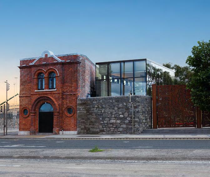
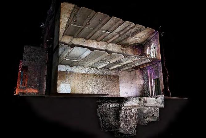
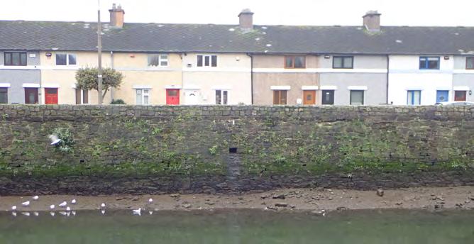
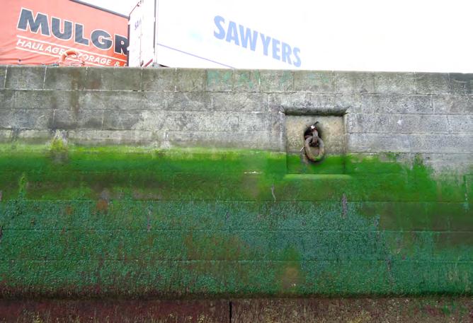
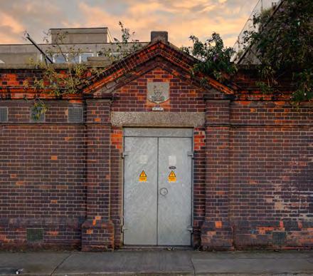
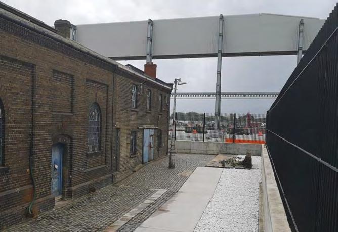
A stretch of the sea wall still stands intact over some 375m, west of Alfie Byrne Bridge. The sea wall survives within the Port Estate as a buried feature, where it lies under the later Port boundary wall that runs along East Wall Road. The road name remembers the sea wall, even if its origins have largely been forgotten. Rehabilitation of the former eletricity substation at the junction of East Wall Road and Alexandra Road in 2023 (now referred to as The Substation) exposed a length of the eastern façade of the sea wall, and this is preserved beneath the substation where visitors can view the wall through a glass panel set into the floor.
South Lotts
The South Lotts was originally a small parcel of land developed on the south side of the Liffey between Moss Street and Creighton Street for housing in the early eighteenth century but came to be associated with a larger swathe of ground extending east to the River Dodder. This is where the Grand Canal Docks would be developed in the late 1700s, and the Dublin and Kingstown Railway and its workshops along with the city’s gasworks in the nineteenth century.
6
The Dodder in its own right was a core location for the Dublin fishing fleet and the many slipways and landing stages recorded on the historic Ordnance Survey maps on the east bank, or right bank of the Dodder at Ringsend highlight the historic focal point. 7 The experience of the Ringsend community with the waters of Dublin Bay may explain why the Port’s pilots traditionally came from here, while the Port’s dockers were from the East Wall and Sherriff Street communities.
Navigation
The delta that formed at the mouth of the Liffey created a multitude of shallow channels, and a large sand bar known as the Dublin Bar formed across the mouth of the river where the riverine sediment held in suspension was released into Dublin Bay. These natural features were impediments to shipping. Plans to initiate specific solutions for navigation, including Captain Perry’s proposal for a marine canal between Fairview and Sutton that would bypass such obstacles (1721 or 1725), did not materialise. 8 The focus instead was on creating a single approach channel across the delta in the hope that such would also scour through the Dublin Bar. These plans would come into focus over time.
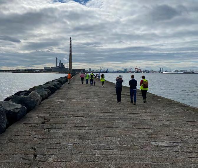
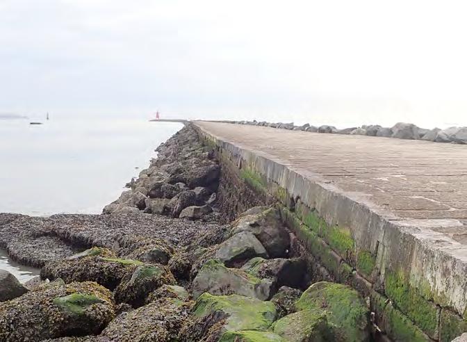
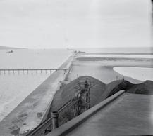
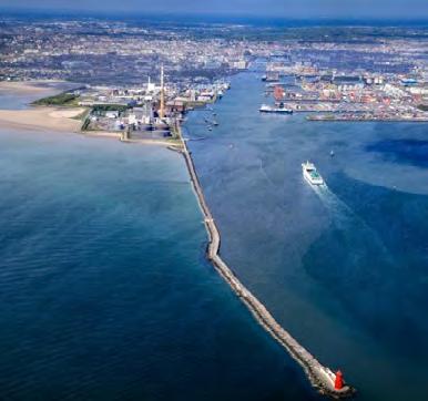
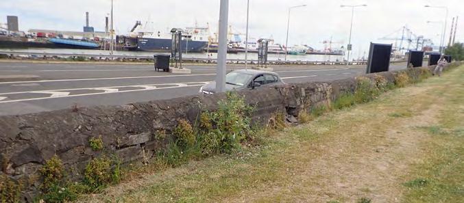
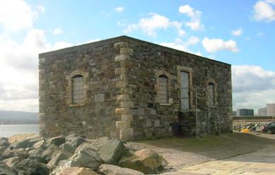
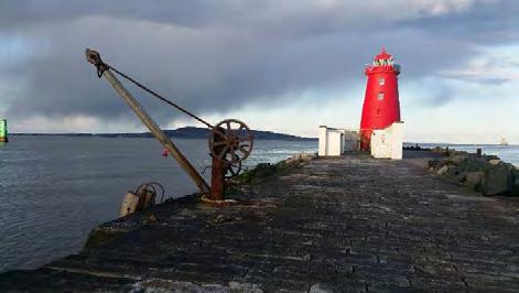
The Great South Wall (RMP DU018-066 and DU019-029, RPS 6797 & 6798) 9
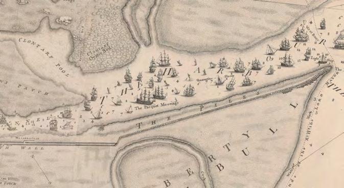
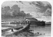
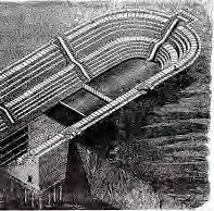
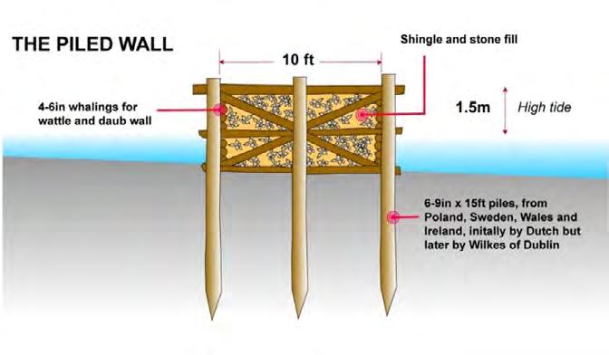
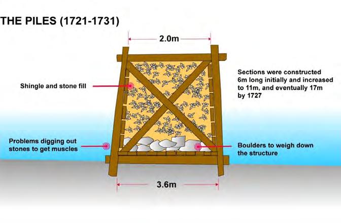
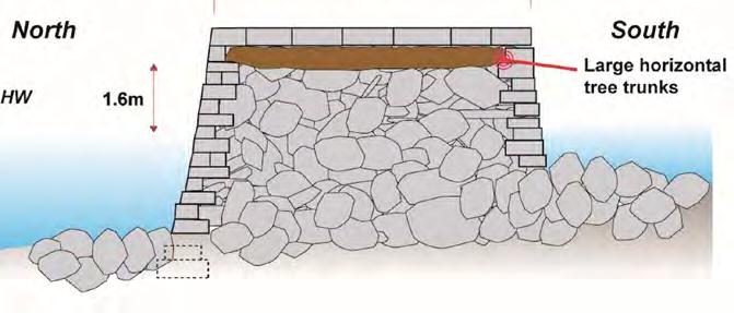
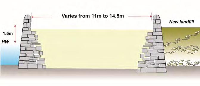
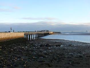
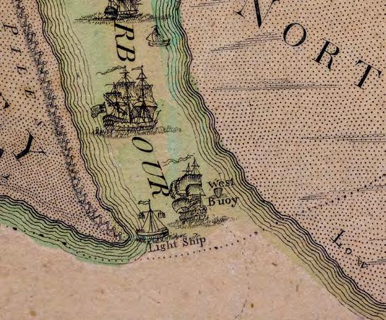
A first attempt was aimed at training the river channel to the east of Ringsend where sands from the South Bull/Sandymount area were encroaching northwards across the delta. In 1716/17 timber piling operations got under way to construct a breakwater that would run between a natural shallows known as the Green Patch to the east of Ringsend and Poolbeg Lighthouse. By 1731 the breakwater was complete and was known simply as ‘The Piles’, reaching 3,109m in length.
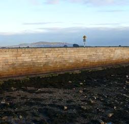
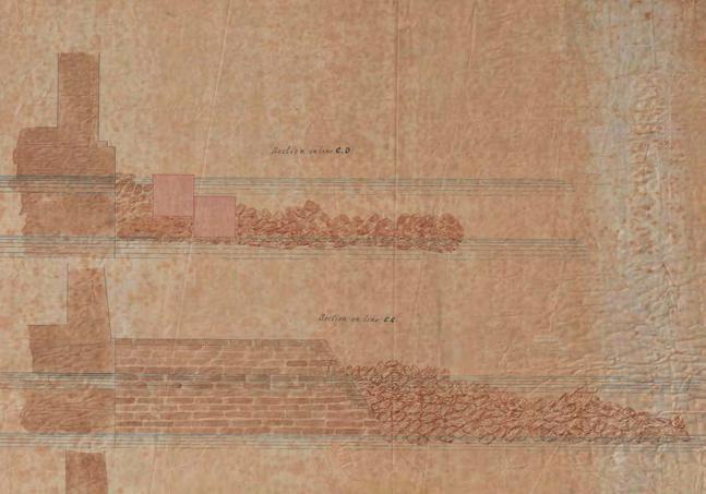
In 1748, the Ballast Board announced plans to construct a double wall in stone that would extend the 2,100m from the west end of the Piles to Ringsend Point. The wall was completed in 1759 and was known as the Ballast Office Wall. It was built with two parallel rubble walls and the intervening space (varying between 37 and 48 feet in width) filled with sand. Today this length of wall lies under Pigeon House Road, but some lengths of its boundary walls are visible as low parapet walls, and a length of the north-facing wall is exposed to its full height as the wall runs alongside the cooling water outfall associated with the ESB Dublin Bay Power Plant.
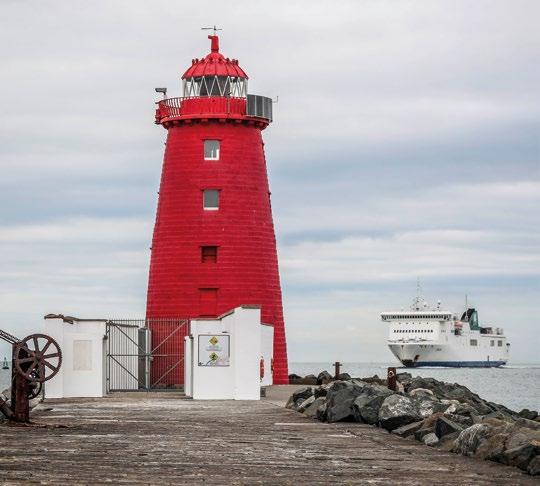
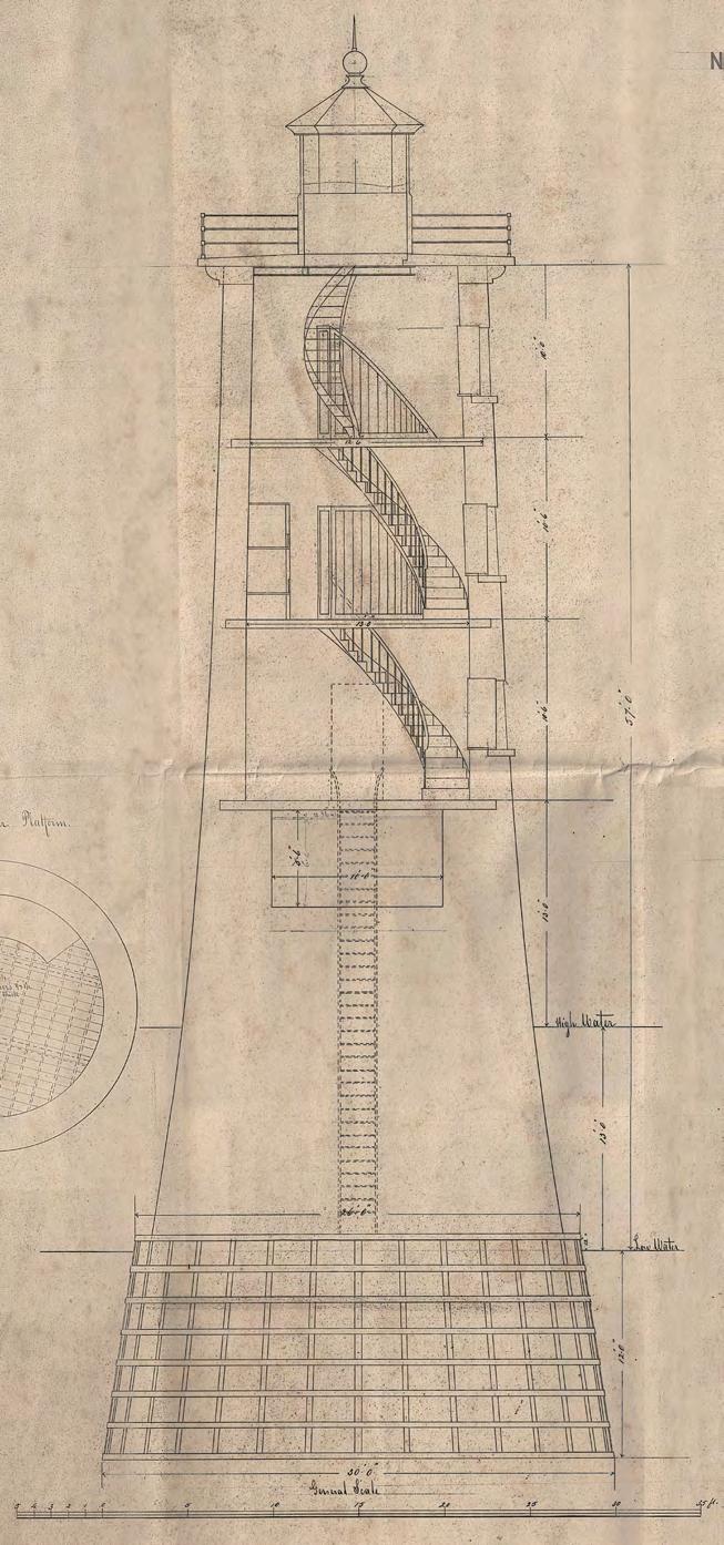
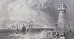
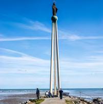
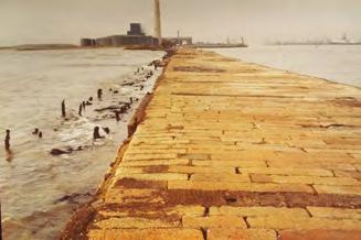
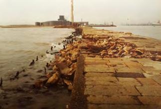
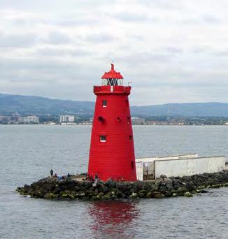
In 1761 work began to extend the wall to Poolbeg, which took over 30 years to complete. The wall was built westwards from Poolbeg and on the north side of The Piles. The early works included laying the foundations for Poolbeg Lighthouse in 1764, which was completed in 1767. The main wall length has a different construction to that of the Ballast Office Wall, comprising a dry rubble core with granite ashlar in distinctive linear-shaped blocks that form the two façades
Laser scan survey showing the eighteenth-century sea wall under the redbrick substation at the junction of East Wall Road and Alexandra Road
Source: ADCO for DPC
East Wall Road Sea Wall opposite Fairview Park
Source: ADCO for DPC
Historic reconstruction drawing showing the East Wall in the early 1700s by Uto Hogerzeil
Source: Uto Hogerzeil for DPC
Conservation Strategy
of the wall and have a 24-feet wide deck surface. Timber coping was employed in places to bond crossing timbers but much of the timber has rotted out and is replaced by cement.
The collective of wall lengths extending east from the Dodder confluence to Poolbeg lighthouse becomes known as the Great South Wall (GSW). The wall does not appear to have produced much beneficial influence on reducing or scouring Dublin Bar but it did protect the river channel from further deposition of the sands from the South Bull. It also acted as a training wall that directed the tidal currents in a more defined channel. When serving in conjunction with the North Bull Wall (1819-1824), the two great walls were then able to induce tidal scour on the Bar.
The GSW is a registered archaeological monument and a protected structure, RMP DU018-066 and DU019-029, RPS 6797 & 6798.
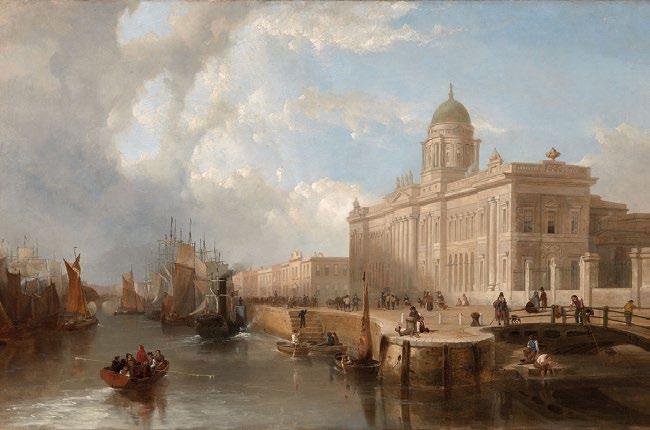
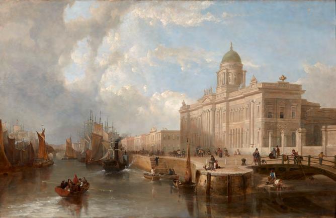
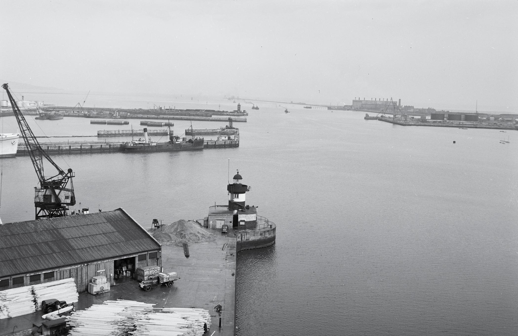
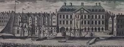
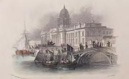
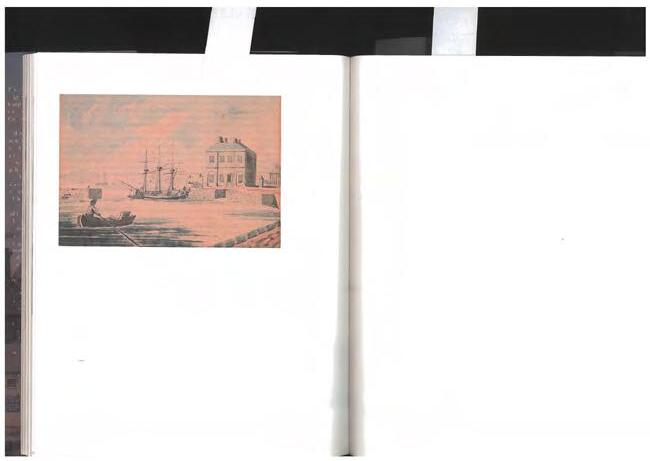
Custom House, Custom House Quay
The creation of a single channel downstream to the mouth of the Dodder and the development of the GSW were first steps in improving navigation to the city. There was now a wider channel with quays downstream of the post-medieval harbour precinct around Essex Bridge where the Custom House (proposed 1705) was located on Wellington Quay. It was not long before there was pressure to move the port centre downstream to where shipping would have better facilities for loading and unloading. In 1780, John Gandon was invited to Dublin to discuss the building of a new custom house. The site was subject to over-topping during spring tides but Gandon’s grand Georgian design was substantially completed by 1791.
The same year, Gandon laid the foundation stone for the future Carlisle Bridge, which opened in 1795. The bridge curtailed shipping upstream of it and cut off ready access to the old Custom House and port area at Wellington Quay. The refocusing of shipping downstream to the new Custom House was facilitated in 1802 when the Wide Streets Commission advised the Ballast Board of their proposal to extend the north quays to the Custom House. The extension was completed in 1814 and became the upstream limit for seagoing vessels. The Carlisle Bridge was subsequently re-built by the Dublin Port and Docks Board and designed by Bindon Blood Stoney. Its renaming to O'Connell Bridge was to tie in with the O'Connell commemoration spirit, and was a better serving structure. O'Connell Bridge opened in 1880.
For centuries, Dublin’s Custom House was both a testament to imperial power and the apex of the legacy of a visionary and powerful oligarchy whose legacy was ‘Georgian’ Dublin. The term ‘Georgian’ is popularly associated with the squares and architectural legacy of that period. The legacy, however, includes the canalisation of the River Liffey and the formation of the matrix of the port which moved progressively eastward.
Canal infrastructure
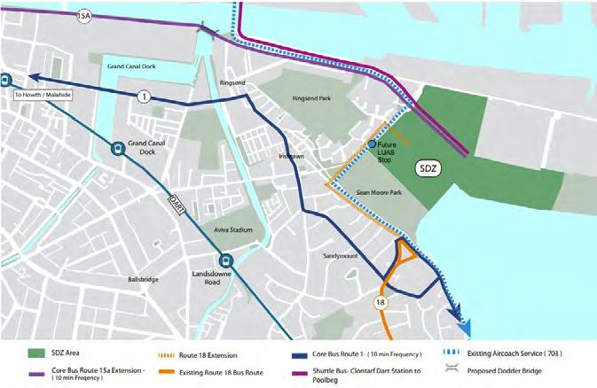
The arrival of canal infrastructure would transform the connectivity of Dublin with the rest of the country, and the Liffey would play an important role in this. Today the canals offer connectivity westwards for wa lkers and cyclists. Luas and DCC's proposed rubber tyred rapid transit system will connect to the gateway of the North Port and the heart of the Poolbeg Peninsula respectively.
The Royal Canal was granted permission to be built in 1789 and by 1803 the canal was connected to the Liffey through lock gates downstream from the Custom House. The Grand Canal in turn was facilitated with a grant in 1791 to construct new docks across the River Dodder from Ringsend and would host three graving docks when it opened in 1796. 10
The connection of the Port to the interior of the country by canals from the late eighteenth century is also part of the legacy of that Augustan Age. The Grand and Royal Canals have imprinted themselves indelibly on the image of the city, and the character and cultures of the interior of the country, notwithstanding that they were progressively superseded by the emerging railways from the 1840s onwards.
It is a testament to the legacy of that epoch that the terms ‘inner canal’ or ‘between the canals’ are popularly in use in describing the historic city, resultant on their connections to Dublin Port. The Grand Canal commenced construction in 1757 and terminated in the Grand Canal Docks/Basin, hosting the three graving docks when it opened in 1796. 11 In their time, the graving docks were the biggest of their kind in the world and represent an exceptional example of Port engineering. Today they are at the heart of the so-called ‘Silicon Docks’ which, like much of the matrix of the eighteenth- and nineteenth-century Port, has been progressively redeveloped in the last four decades years, contributing significantly to the Irish economy.
A survey of the City of Dublin, John Roque, 1757, detail of Source: Dublin Port Archive
Parapet of the GSW stands today as a low boundary wall on Pigeon House Road in close proximity to the operational port, and has been breached in many places
The Royal Canal commenced construction in 1790 and originally terminated in Broadstone (1801), but was later linked to the Port at Spencer Dock in 1817. Both canals, and particularly the Royal Canal, struggled throughout their history to be economically viable. The bankrupted Royal Canal was purchased by the Midland and Great Western Railway Co. in 1845. The route and related lands were extensively used to host the emerging railway, which connected with the Port at the North Wall, in 1864.
The Grand Canal did not offer itself as a rail corridor. However, in 1877, the Great Southern and Western Railway Co. created a link to the Port via a bridge crossing over the Liffey, north of Kingsbridge (now Heuston Station), then through a tunnel in the Phoenix Park, on to circling the emerging Victorian City, passing through cuttings in Cabra, and ultimately joining with the M.G.W.R.Co. line at Glasnevin, and thence to the North Wall.
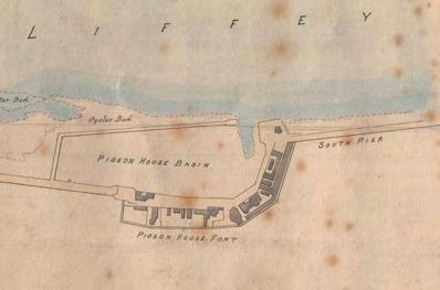
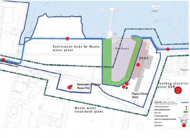
Pigeon House Harbour and Fort – Pigeon House Precinct
As developments were restructuring the focus of port activities within the city area, the presence of the GSW breakwater offered opportunities along what would become the Poolbeg Peninsula.
Rocque’s map of 1757 records ‘The Pacquet Moorings’ next to The Piles and so highlights the existence of moorings that served the cross-channel ferry service of the eighteenth century. Interestingly, this is pretty much where the ferries berth today, albeit on the north side of the channel. Ringsend provided passengers with lodgings from where they would journey to the moorings, at first by tender and then along the GSW. It was not long before attention was directed towards making this location an accommodating haven. The Green Patch had served as a depot during the construction of the GSW, and John Pidgeon was the watch man in the first structure. In 1761 a timber structure was replaced with one of stone and John Pidgeon became the first caretaker of this ‘Blockhouse’ stores. The Blockhouse became a refuge in times of bad weather and was known locally as ‘Pidgeon’s House’. In 1766, the Ballast Office ‘ordered two new wharfs to be built at the end of the new wall near the blockhouse, one at each side, for the more convenient landing…that may be necessary’.12 John Pidgeon died in 1786 and the following year the blockhouse was replaced by the Ballast Board with an eight-roomed building for the Inspector of Works, and the new caretaker continued providing meals and refreshments for the tourists. The plan for the harbour was made in 1791 and construction was completed in 1793, in the same year that a more
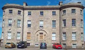
elaborate accommodation was built in the form of Pigeon House Hotel, which remains today and is a protected structure (RMP DU019-027).
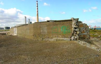
In 1793, the Half-Moon Battery (DU019-028), a three-gun platform battery, was built along the GSW to protect ships from privateer attacks, while the 1798 Rebellion led the government to requisition the Pigeon House precinct as a temporary military fort that lasted until 1897. The army’s presence led to the construction of defensive walls and gateways and a series of buildings within the fortified enclosure. The commercial business of the harbour continued until 1813 when the mailboats were directed to the new harbour in Howth, and it was only in 1814 that the hotel served as Officer’s quarters, while meals were still provided ‘for good fellows’ as late as 1848.
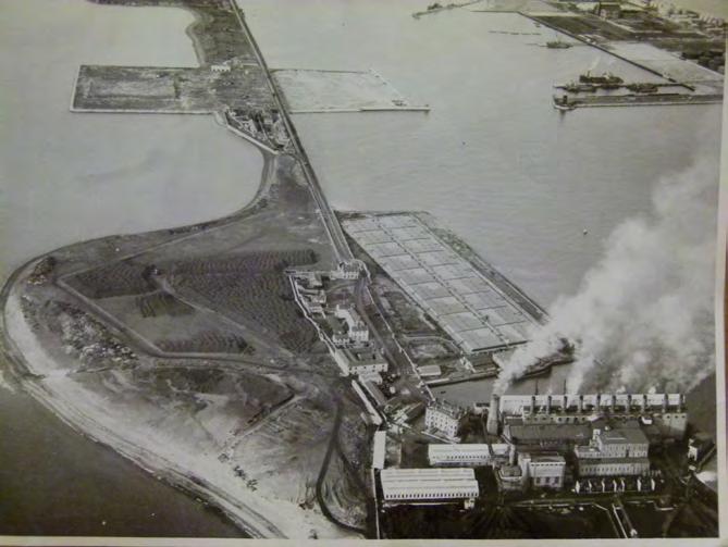
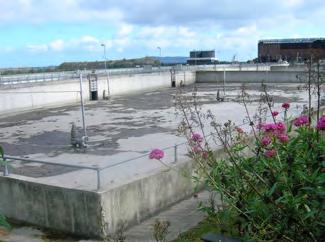
In 1897, Dublin Corporation bought the fort from the (British) Ministry of Defence. The site served as a base for utilities’ operations. The first operation upgraded the metropolitan sewerage scheme, which was discharging raw sewerage into the Liffey at the White Bank to the east of the fort. The decision was taken to fill in much of the harbour with a series of sludge beds that were opened in 1906 and which still operate today, albeit as storm overflows, and are registered on the Dublin City Industrial Heritage Record (DCIHR 19_09_004_01). The use of the peninsula for waste-water processing continues, and the footprint of those operations has expanded to the south and are being managed by Irish Water.
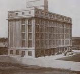
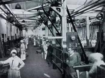
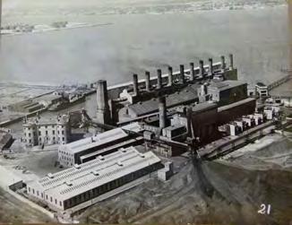
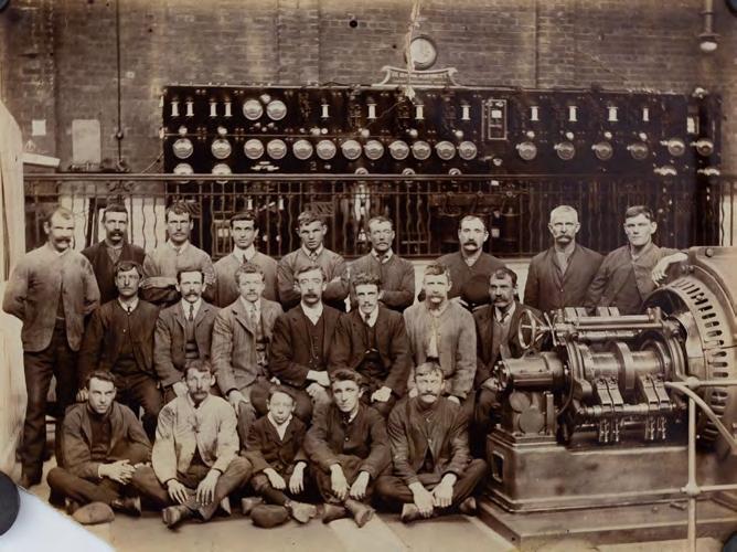
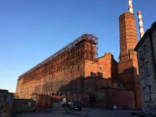
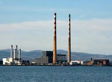
The precinct also served power generation, and the three-storey monumental redbrick building that was built along the east side of the harbour in 1902 became the first electricity generating plant in the world to generate three-phase electricity (19_09_006_01). The Corporation handed over the Dublin Electricity Generating Station to the ESB on its formation in 1927. This was the start of the ESB’s presence on the Poolbeg Peninsula, which expanded through land reclamation in the 1970s.
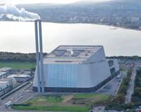
Decommissioned in 1976, the Corporation reacquired the generating station in the late 1990s to facilitate the ‘Waste to Energy’ plant, which was ultimately constructed on an adjacent site.
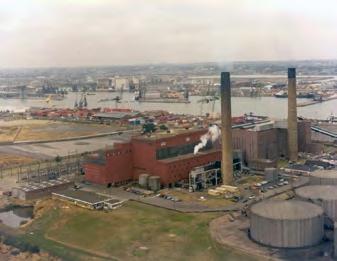
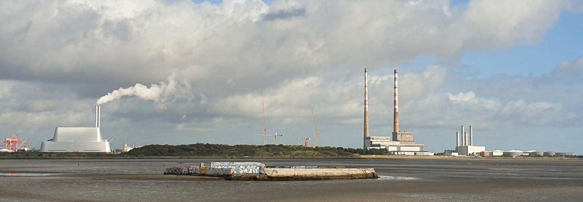
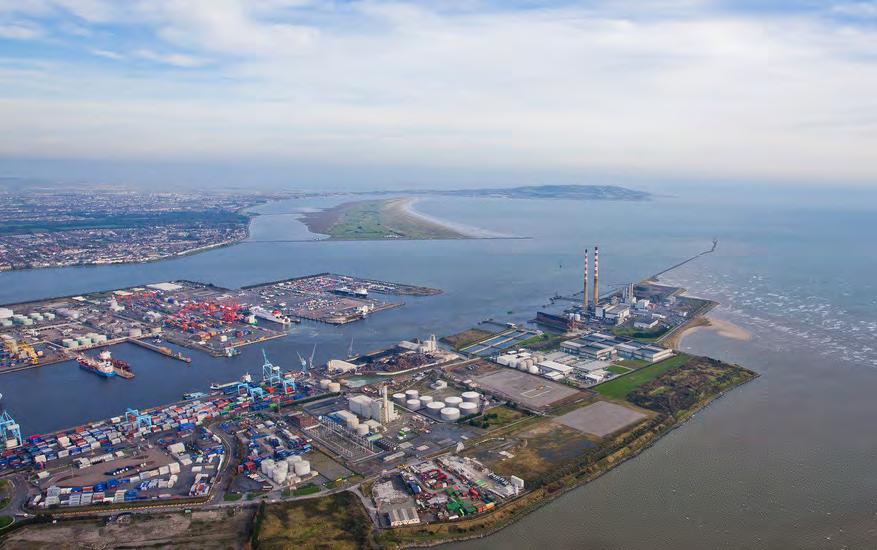
The Poolbeg Electricity Station was built to the east of the former generating station as an oil-fired station and continues to serve. The station includes the now-decommissioned twin concrete towers that are an iconic symbol of Dublin today.
Pigeon House Fort, Samuel Brocas, c 1810
Source: National Library of Ireland, print 1963
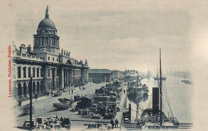
Historic postcard showing Custom House and Quays, Lawrence, Publisher
Source: Dublin Port Archive ref 7823
Custom House, 1851 by Richard Brydges Beechey
Source: Dublin Port Archive ref 7664
Conservation Strategy
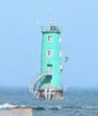
North Bull Wall (NIAH 50030056)
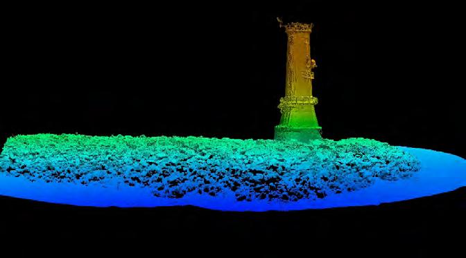
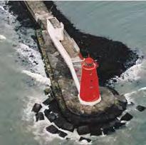
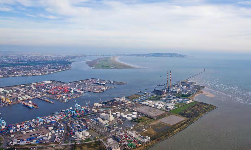
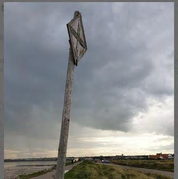
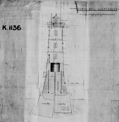
Construction of the GSW resulted in noticeable improvements for navigation in the Liffey channel but impediments to navigation remained, including great obstruction caused by the Dublin Bar. The early nineteenth century saw a range of plans from marine surveyors, including Captain Bligh’s proposal for a training wall that would run parallel with the GSW (1800). The solution decided upon was to construct the Great North Wall (1819-1824), or Bull Wall, under the direction of George Halpin, inspector of works to the Port Corporation, and Francis Giles. The wall is a rubble construction using quarried stone and was built in stages, which permitted observation of its effect on inducing scour. The wall is 9,000-feet long (2.7km). The landward 5,600 feet (1.7km) section stands above the HWM while the remainder is submerged, is only visible at Low Water and stands 1-foot above the LWM. Its toe lies 1,000 feet from the terminus of the GSW. 13 The intended purpose of allowing the seaward length of the breakwater to be submerged was to reduce outflow velocities at High Water, enabling sailing ships to successfully navigate the approach channel and the safe haven of the Port. By the time the North Bull Lighthouse was built (1889), the depth of the channel across the bar had increased from 6 feet, in 1819, to 16.5 feet at low water on spring tides. The growth of Bull Island to the north – a UNESCO designated Biosphere Reserve since 1988 – is directly attributed to the changes in sand deposition resulting from the work done to induce scour across the Dublin Bar.
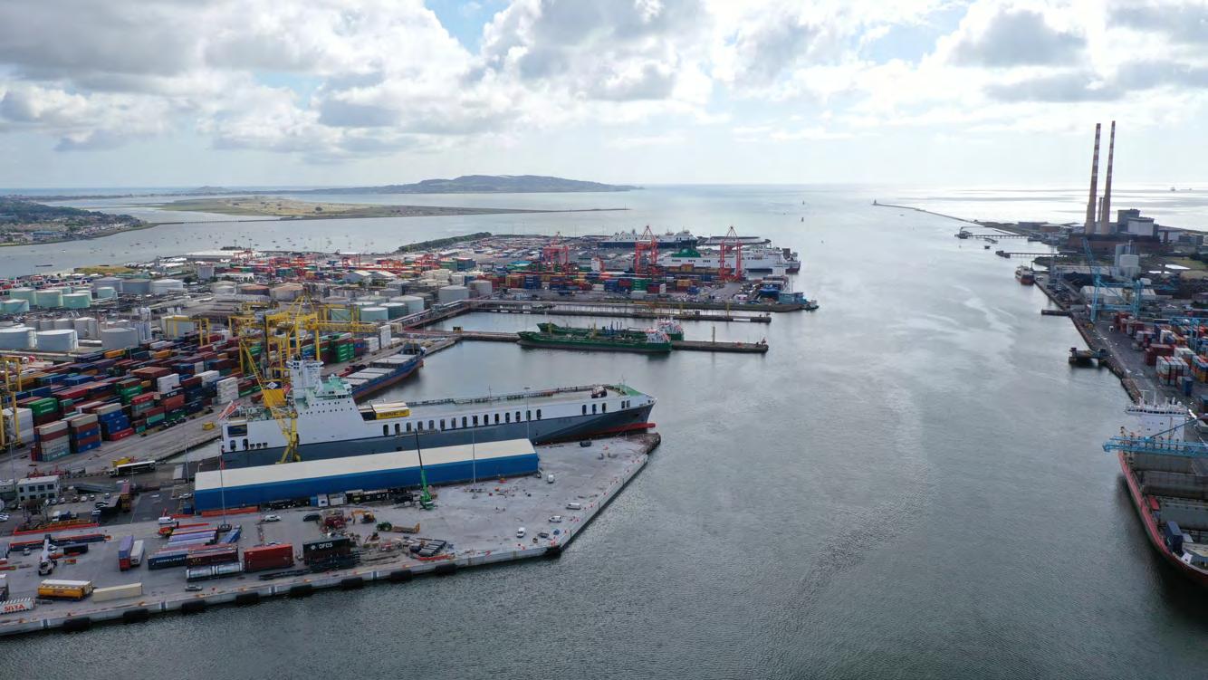
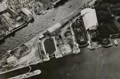
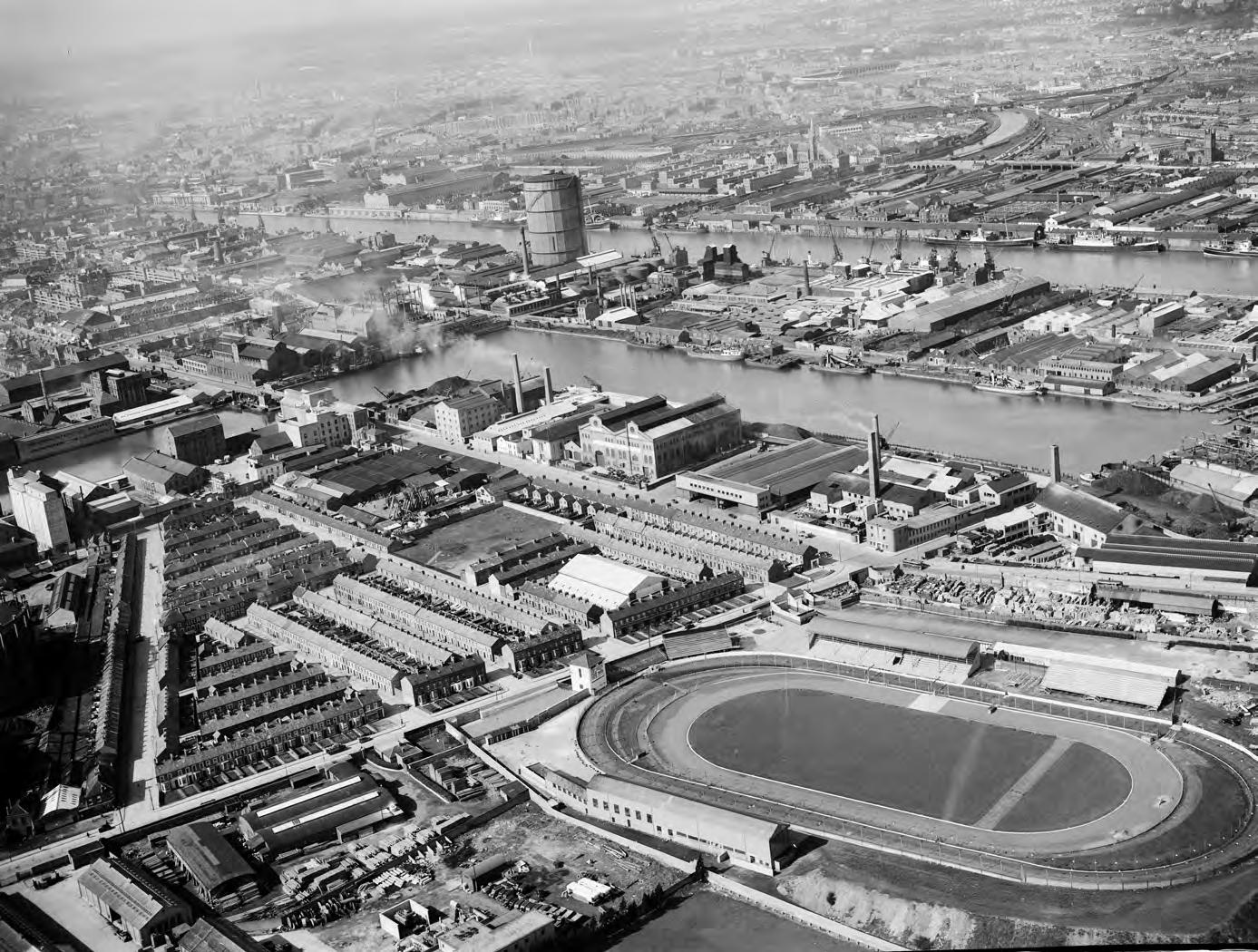
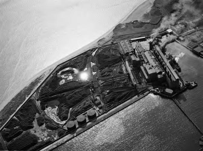
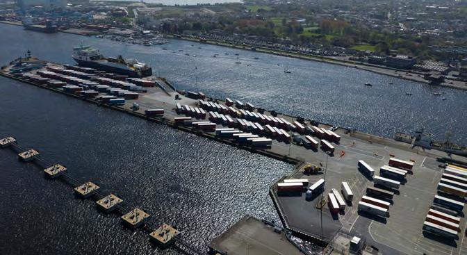
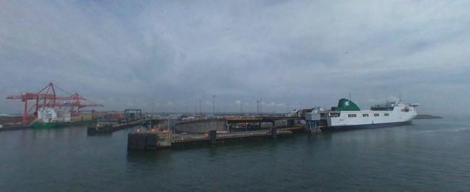
Alexandra Basin, a deepwater entity
With the principal issues associated with navigation along the approach channel being dealt with, attention focused on the port facilities. Shipping had been moored along the city quays when tidal access permitted but the development of steam ships and the demand for increased sea traffic meant that such resources were no longer adequate. The needs of the rapidly developing port soon out-paced the ability of the slipways and the existing Grand Canal Basin dry docks to service the vessels using Dublin Port. The largely undeveloped north side of the Liffey at East Quay became the principal location for attending to ship repair and maintenance.
The new developments began with No. 1 Graving Slip in 1826. In 1832 a second graving slip was built. These were followed by further constructions, including the timber-built Steam Packet Wharf that
was constructed in the 1830s to serve the most southerly area. The wharf was a temporary structure that was defined more formally in 1885 with the construction of Crossberth Quay.
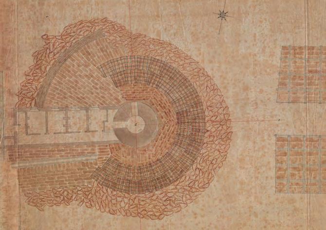
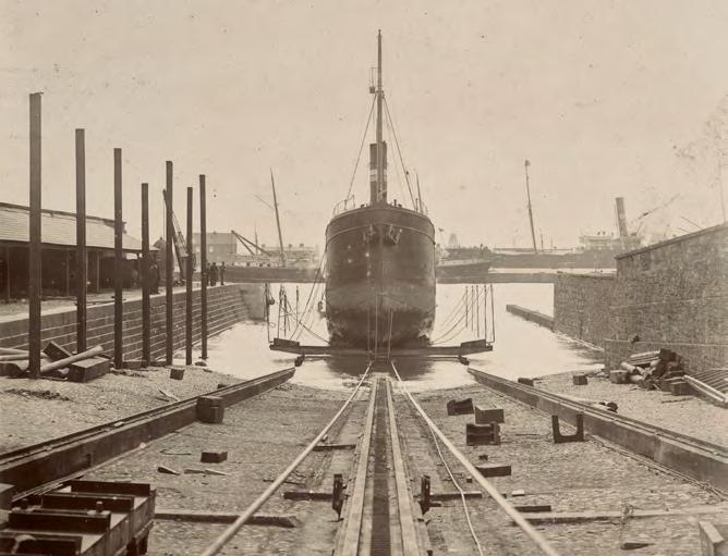
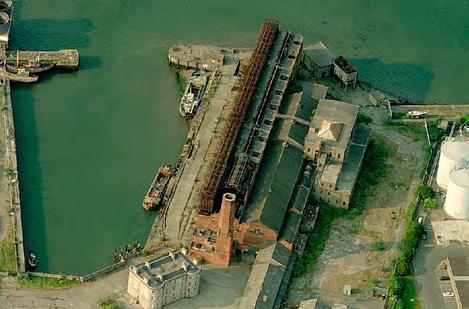
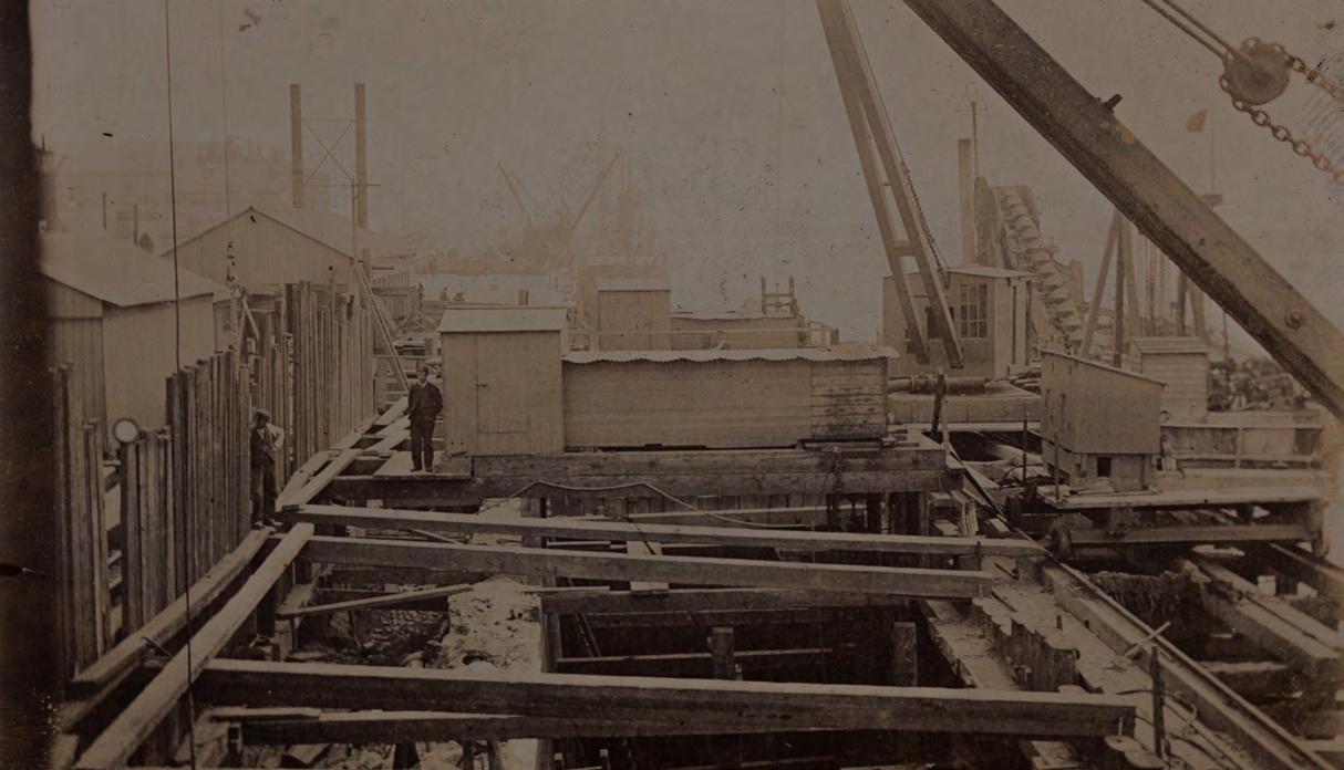
Plans were made in 1850 to construct a formal dry dock. Graving Dock No. 1 was designed by William Dargan with his young assistant engineer, Bindon Blood Stoney. The dock was opened in 1860 and measured 410 feet long and 80 feet wide. It was constructed using granite ashlar blocks to form a stepped façade down its sides and was curved at its north end. A dedicated pump house was built on the east side of the dock. The dock was closed in 1989 and filledin under archaeological supervision in 2008. The pump house still stands (NIAH 5000587) and its curtilage has been refurbished as part of the ABR Project and the re-opening of the Graving Dock precinct.
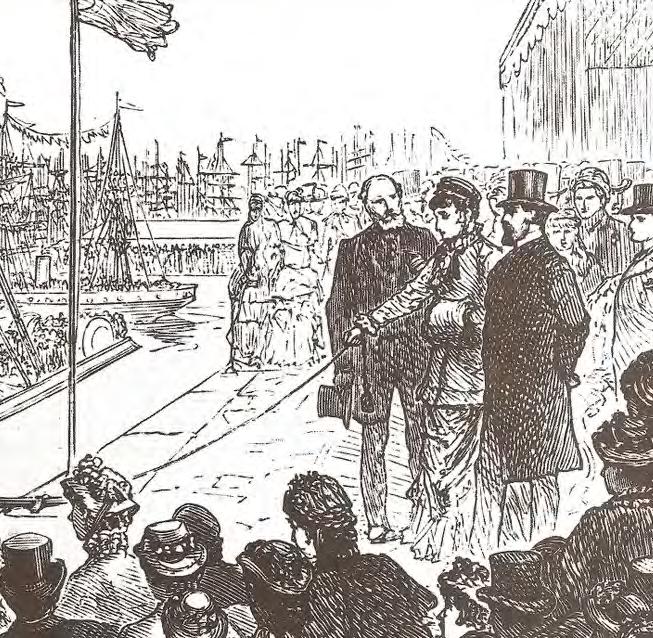
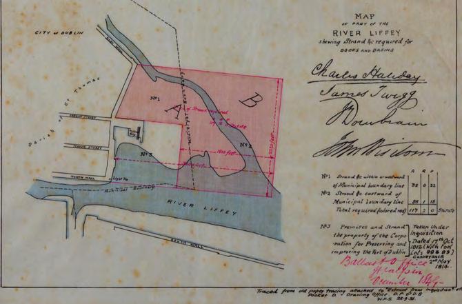
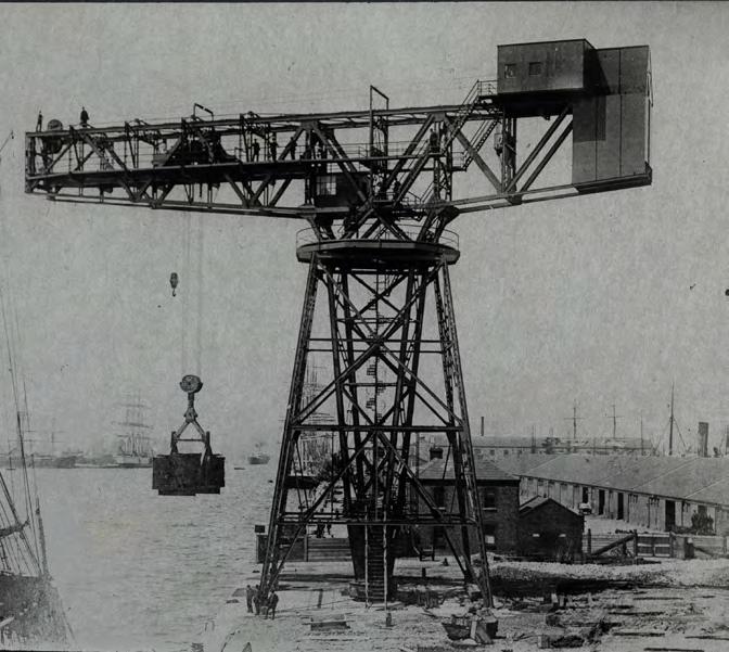
Through the Dublin Ballast Board, the port continued to infill and extend its growing facility, but the single most ambitious aspect was the development of the deep water basin, whose opening in 1885 by the Prince and Princess of Wales, the later King Edward VII and his Queen, gave their name to Alexandra Basin. The basin forms the southern half of the reclamation project and it absorbed the preceding developments. It was a grand design that extended from the East Quay on its north side eastwards along what is now Tolka Quay Road to the Eastern Breakwater that was built between 1858 and 1884 on what is now Breakwater Road, where the breakwater ran south towards the channel.
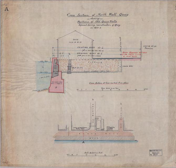
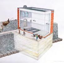
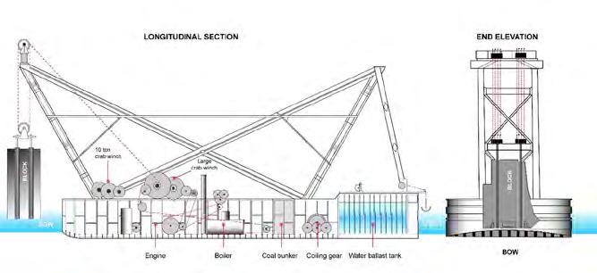
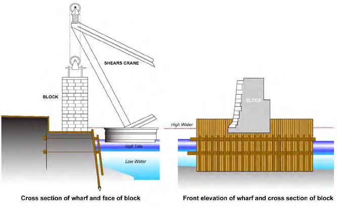
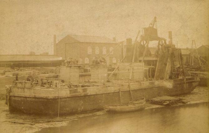
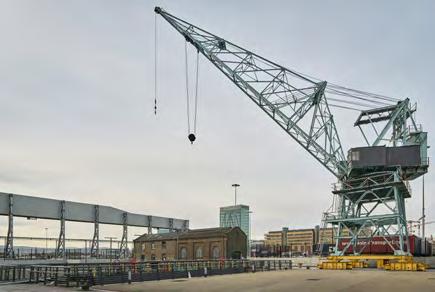
The south side of the basin is retained within the North Wall Quay Extension, which was designed by Stoney based on the radical idea of making 360-ton pre-cast foundation blocks using Portland cement, granite monoliths and iron girders. The seabed was prepared by workmen operating from within the diving bell, and the blocks were floated into position and lowered to the seabed.
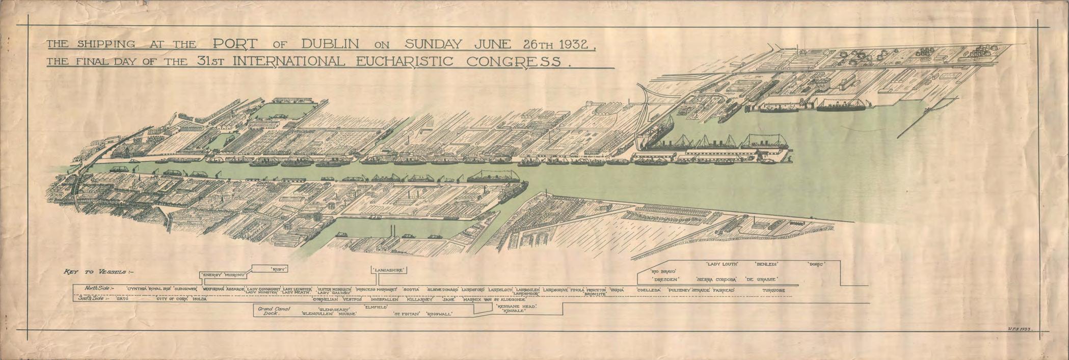
North Wall Quay Extension was completed in the twentieth century, as part of preparations for the Eucharistic Congress of 1932. By this time, a new form of caisson design had been developed for works in the Port, and it fell to the then engineer Joseph Mallagh to complete.
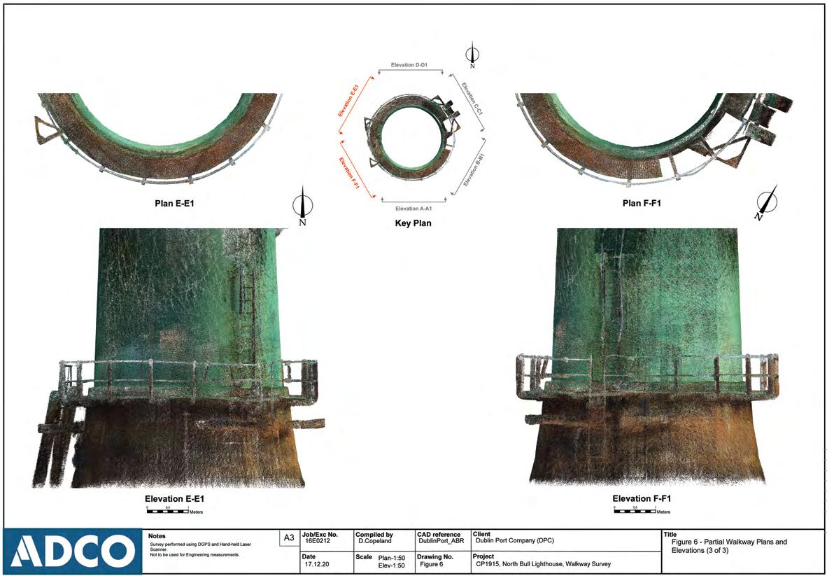
North Bull Wall and Lighthouse, multi-beam image showing above and below the waterline
Source: Hydromaster for DPC
North Wall Quay Extension, Alexandra Basin Source: ADCO for DPC
Historic engineering drawing of Alexandra Basin Reclamation Source: Dublin Port Archive
Berthing Arrangement for the Eucharistic Congress, 1932
Source: Dublin Port Archive
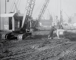
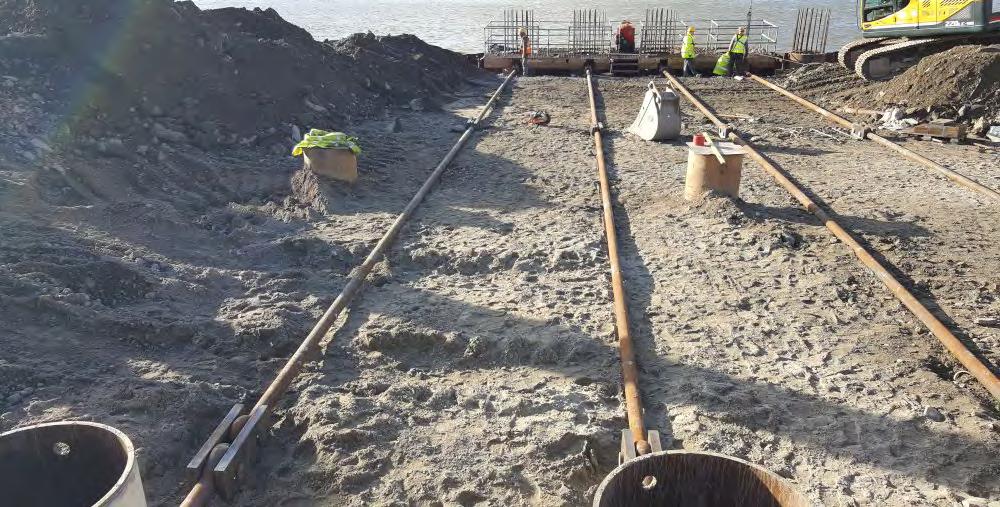
Alexandra Basin has remained a key focus of the Port as it has continued to develop, and the Alexandra Basin Redevelopment Project (2016-25) is upgrading the quays to accommodate future needs,includingsea-levelrise.Theworkhasprovidedtheopportunity to expose and record much of the historic fabric of the port area.
The basin has served as the principal landing place for numerous events, some of which have wider narratives across the city, including the Dublin Lockout 1913-14; as a marshalling yard for British Army needs during WWI and during the Easter Rising; it was from here that the British Army withdrew from Dublin in 1922; and it was here that ships associated with the Eucharistic Congress in 1932 berthed.
The sea area to the north of Alexandra Basin would become hard standing and its reclamation programme would take time to complete. To improve access to the land north and east of the graving dock and to the graving dock itself, Alexandra Road was commenced in 1881. The road would serve to separate industrial activities, with shipbuilding and repair to the south next to the basin, and chemical works and fuel storage to the north.
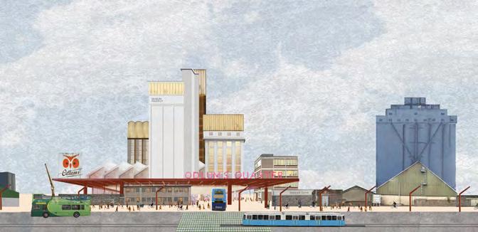
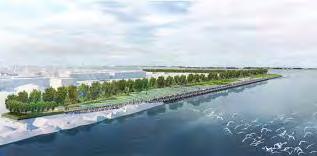
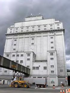
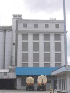
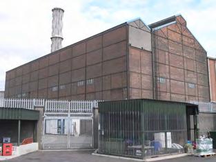
In 1931, Alexandra Quay was established and this has continued to be the reception area for grain. The former Merchant’s Warehousing Company’s grain silo, now R&H Hall’s grain silo and a protected structure (RPS 8785, NIAH 50060589), was originally designed by the architectural firm Batchelor and Hicks as a detached ninebay 15-20-storey reinforced concrete silo It was built in 1915–20 by J & W Stewart and has had two principal phases of additions, in c 1932 and c. 1937 respectively. The Flour Mill Masterplan 2019 encompasses the redevelopment of the former Port Milling Company's complex (formerly Odlum's), which stands next to the R&H Hall silo and is linked by the east-west elevated gantry, a protected structure, denoted in the RPS description for R&H Hall. DPC is actively working on this special project intending it to serve as a focal point of the port's Distributed Museum.
In 1940, Ocean Pier was developed to the east, splitting the basin in two with the activities in Alexandra Basin East focused on the reception of fuel ships.
The boundary wall that extends north from the entrance along East Wall Road to Tolka Quay was originally constructed in the late 1880s and early 1890s to protect the Port lands from trespass. Lengths of the boundary wall will be reduced and repositioned as
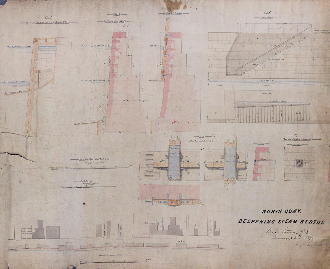
Section through North Wall Quay showing Bindon Blood Stoney foundation blocks with ashlar quay stones above
Source: Dublin Port Archives, ref 8853
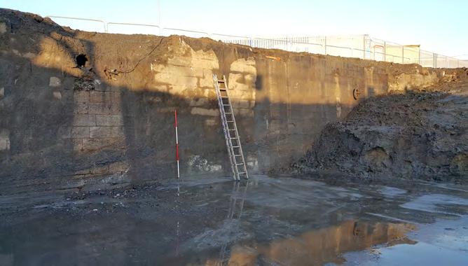
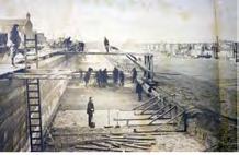
Patent Slip Quay under excavation, 2018
Source: ADCO for DPC
part of the Liffey-Tolka Project (LTP) pedestrian and cycleway that will run alongside East Wall Road and is an initiative of Dublin Port Company’s policy to advance Port-City Integration. The LTP will also rehabilitate the granite capstones of the former Crossberth Quay and East Quay, which were filled-in in the 1980s and ‘90s.
The Port of Dublin has remained at the centre of important economic and cultural moments, the dynamic of which is embodied in the ever changing and growing nature of the Port facility. Further reclamation works in the twentieth century have pushed the boundaries of the Port area to the north along the East Wall towards the Clontarf shoreline, and eastwards to define the current extent of Dublin Port.
The south port area has also been developed. Early reclamation to the south of the GSW provided a narrow strip of land to the west of the Pigeon House harbour and it is here that what began as a fever hospital became the Allan R Ryan Hospital for Consumption, which was officially opened in 1910 for the treatment of tuberculosis. By 1918 it was under the care of the Sisters of Charity of St Vincent de Paul, who had a chapel added to the complex. 14 The site is currently occupied by All Away Waste. A later building was constructed to the west of the hospital and is recorded as St Catherine’s Annexe but the building does not survive above ground today.
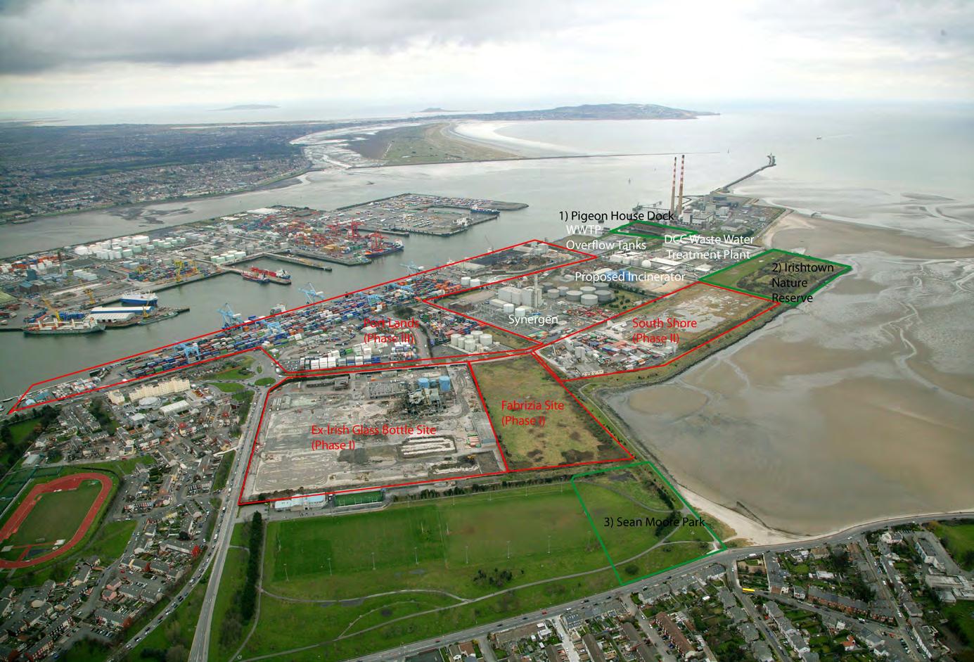
The second half of the twentieth century saw significant development on the peninsula involving further land reclamation either side of Pigeon House Road, with the construction of new quaysides to the north, the expansion of water treatment and power generation to the south and east, and Irishtown Nature Park on a former landfill site between Pigeon House Road and Sandymount. Covanta’s Waste to Energy site was developed in the early 2000s.
Rail linkages
Prior to the regeneration of the so-called 'Docklands' the legacy of the rail connections to the Port were readily evident, particularly in the environs of the North Wall. The current regenerated Spencer Dock was until the late 1990s an extensive array of railway sidings owned by CIE/Iarnród Éireann.
Other remnants of that epoch survive in part or in whole, notably the former terminus of the London and North-western Railway Co. on North Wall Quay, and its related Hotel.
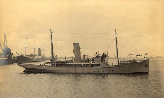
The present-day Port Centre area is above the former ship-building yard. Among the vessels built there was the Helga II, the 323-ton cruiser built in 1908 as a fishery protection vessel and also used for scientific research, including the survey of Clare Island from 1909 to 1911. The Royal Navy requisitioned the Helga II in 1915, renaming her HMY Helga. She was used to shell positions in Dublin city centre during the 1916 Easter Rising. In 1918, the Helga attacked a submarine off the Isle of Man and was also involved in the rescue of 90 people from the RMS Leinster, which was torpedoed off the Kish Bank in 1918 and is regarded among the greatest maritime tragedies in Irish waters. After the war, the Helga resumed its fisheries duties and was transferred to the newly-formed Free State Government in 1922. She served as a troop transport along the Munster coast during the Civil War and transported Republican prisoners from Donegal to Dublin. In 1923, the vessel was renamed Muirchú to serve in the newly-established Coastal and Marine Service. With the outbreak of World War II in 1939, she was refitted to resume anti-submarine patrols. At the close of the war, the Muirchú was the first ship to be commissioned by the newlyformed Irish Naval Service but was decommissioned when the Naval Service purchased three corvettes from the Royal Navy. The Muirchú was then sold for scrap, to be broken up at Hammond Lane on the south side of the Liffey from where she had been made only 39 years earlier, but she foundered while being towed from Cork to Dublin. 15
Another notable remnant of the era is the Point Depot. This was built as a terminus for the Midland and Great Western Railway Co. in 1878. It is now subsumed into the landmark 3Arena and is at the heart of the Point Village, which faces the western boundary of Dublin Port The Point is also the terminus of the Luas Red Line since 2009, providing the public with access to the Western Gateway of the Port, which is part of recent and current works associated with rehabilitating the Port’s boundary along East Wall Road.
Rail connections to the heart of the contemporary Port are long established via Alexandra Road. The expansion and development of rail freight remains integral to the future of Dublin Port’s operations.
Sub-tidal
The underwater environment retains its own narrative that adds to the complex history of the Port’s maritime industrial cultural landscape. The deltine nature of the Liffey estuary retains the potential for submerged landscape observations that may survive in the buried strata below the seabed. The discovery of a fish trap dating to the Mesolithic period (c. 6,000 BC) at Spencer Dock presents clear evidence of early activities along the sand flats.16
The volume of shipping entering and leaving the Port and the city only continues to grow and the navigation hazards that focused the attention of the Corporation and the Ballast Board have left their mark, both in terms of navigation aids to facilitate shipping (for example, mooring beacons and lightships historically and lighthouses and dredging works more recently), and as shipwreck events.
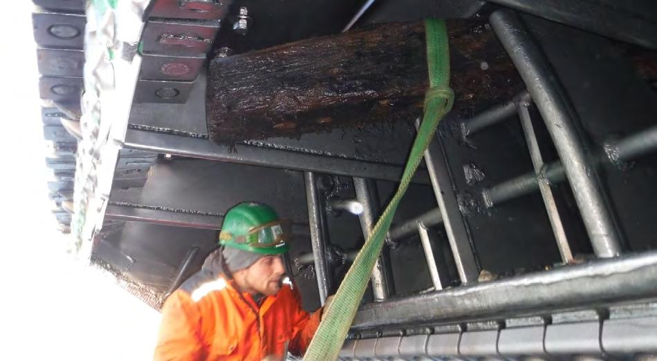
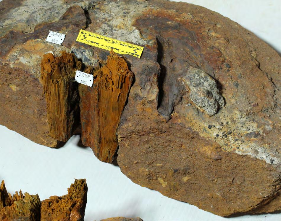
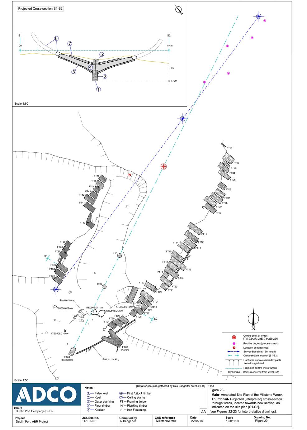
There are more than 300 recorded shipwrecking events associated with the approaches to Dublin, and there are many fewer known shipwreck sites in the immediate environs of the approach channel (see map pp 86-87). One of the unknown shipwreck sites was discovered during the Alexandra Basin Redevelopment Project, when the ruling depth of the approach channel was lowered by 3m from –7m to –10m Chart Datum. The 'Millstone wreck' lies approximately 1km east of the North Bull Lighthouse, at the base of the widened approach channel. A second site was located under Poolbeg Lighthouse and may represent a wreck that has been buried by later rock armour or includes the remains of timber kishes used in the construction of the GSW terminus.
Helga II
Source: National Museum of Ireland
Ship’s timber recovered in dredge head, 2017, during archaeological monitoring
Source: ADCO for DPC
Detail of Millstone, recovered during archaeological monitoring of dredging, 2017
Source: ADCO for DPC
Archaeological plan of the Millstone Wreck.
Source: ADCO for DPC
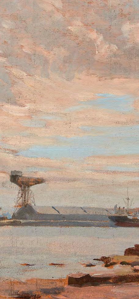
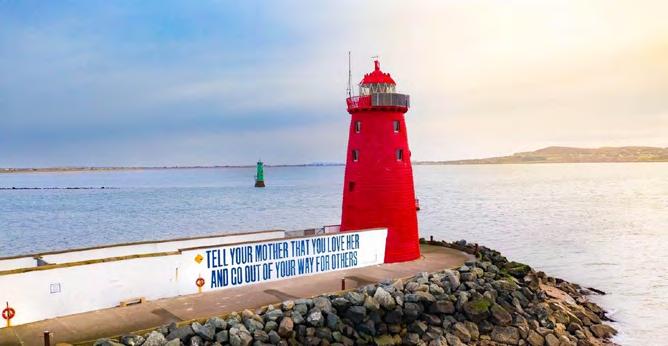
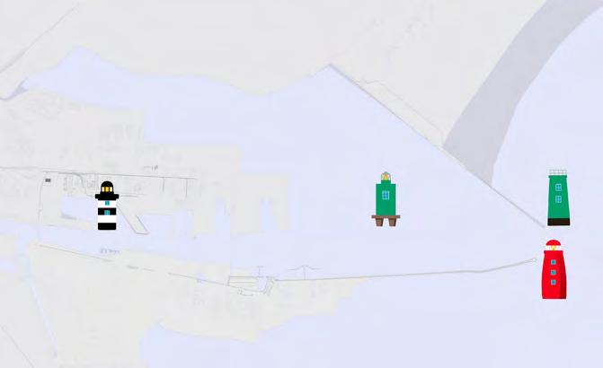
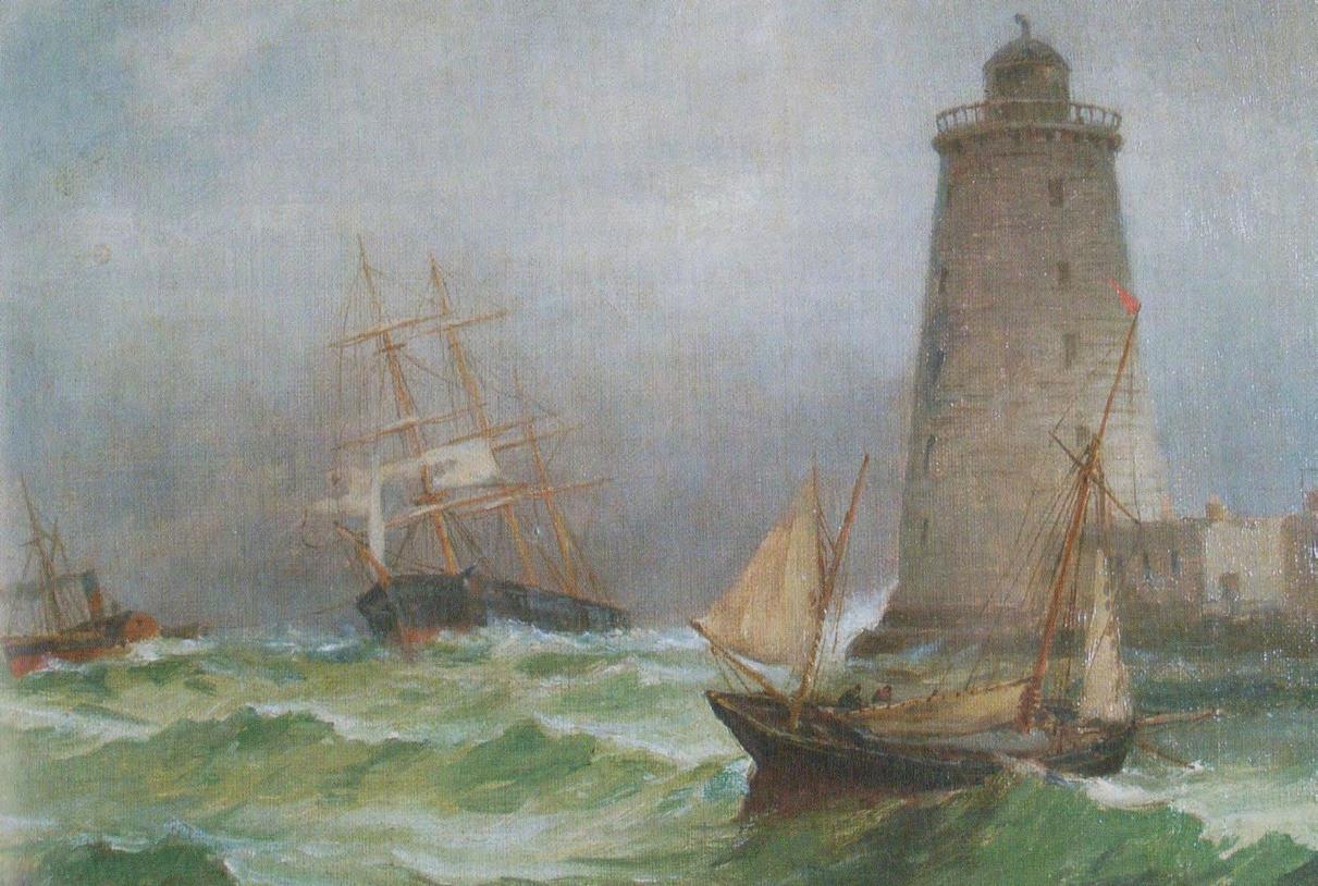
Poolbeg Lighthouse today
Source: Dubin Port Archive
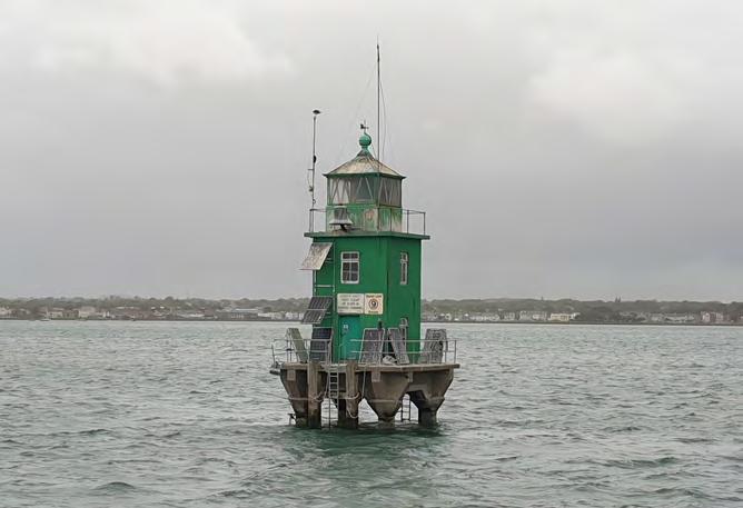
North Bank Lighthouse
Source: ADCO for DPC
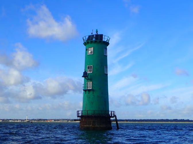
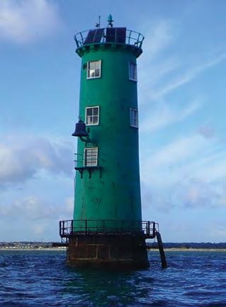
North Bull Lighthouse
Source: ADCO for DPC
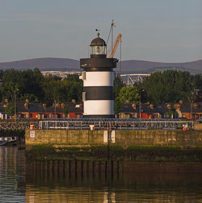
North Wall Quay Extension Lighthouse
Source: Dublin Port Archive
Interior of North Wall Quay Lighthouse
Source: ADCO for DPC
Breakwater Lighthouse, which no longer survives
Source: Dublin Port Archive
Lighthouse Locations Dublin Port
Source: Dublin Port Archive
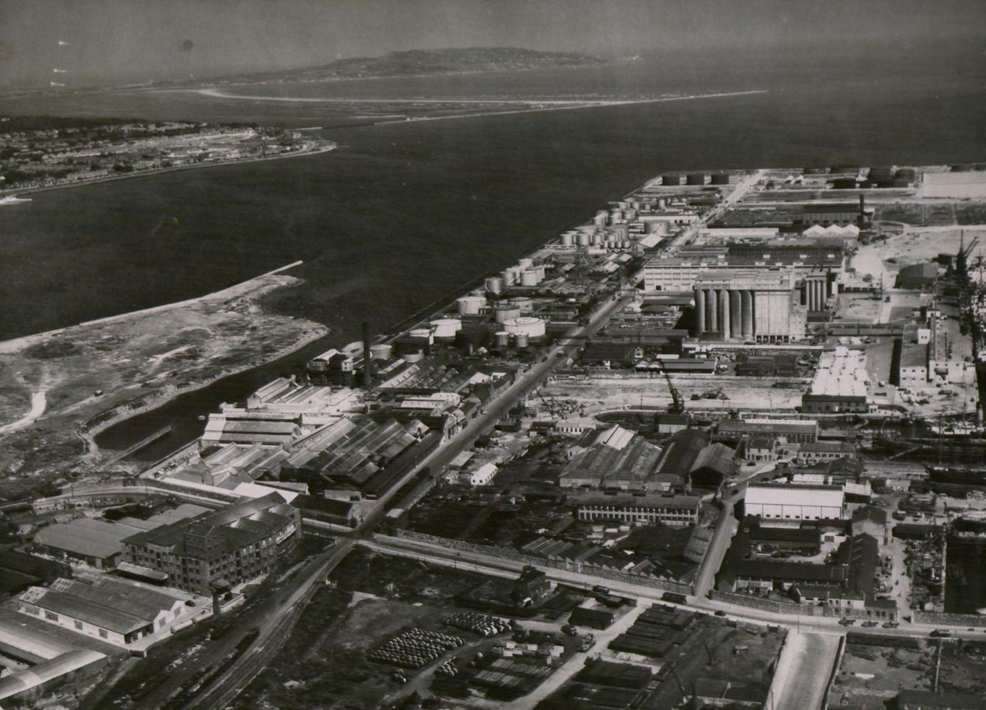
Aerial view c. 1950s looking east along North Wall Quay Lighthouse and onward to Breakwater Lighthouse
Source: Dublin Port Archive, ref 0057
1620-1653
1620
1644
1653 Boate "with an ordinary tide you cannot go to the
Conservation Strategy
1707-1786 Timeline
Ballast Office Liffey improvements commence, to include straightening of river channel
The Ballast Board is established under the Ballast Office Act. Their remit includes ensuring that sand is not removed from the port foreshores
Sir John Rogerson’s Quay under construction by 1716, foreshadowing reclamation and construction of the South Lotts from 1723
North Lotts leasing begins reclaimed land
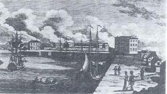
Great South Wall, 1841, engraved by JC Bentley, drawing by William Bartlett
1761: John Pigeon becomes caretaker of the blockhouse 1791:A harbour to be called
Pigeon House Harbour or Dock is planned
The Ballast Office begins River Dodder embankment works. The Pembroke Estate’s land increases as a result
Poolbeg Lighthouse opens
Custom House, Dublin, 1841 engraved by JC Bentley, drawing by William Bartlett
The Lighthouse at Poolbeg (William Sadler)
Custom’s House (James Malton, 1793)
1792 The Ballast Board establishes a committee to liaise with the Fitzwilliam Estate. Dublin Port then begins acquisition of foreshore north of the GSW, approved in 1800 after lengthy debate with the Pembroke Estate and the Dublin Corporation
Pigeon House Hotel
1800
The Fitzwilliam Estate owns approximately 150 acres in Ringsend. This substantial increase from 1693 (Branagan)
Dublin Port acquires further foreshore adjacent to the 1792 lands. This is not developed until the 1950s
The Fitzwilliam Estate passes to the Earl of Pembroke, becoming the Pembroke Estate.
1821 George’s Dock Opens
1824 North Bull Wall completed 1834 First Railway Station in Dublin Opens (Westland Row)
Lands taken from the Corporation of the Borough of Dublin allow Dublin Port to begin works for Alexandra Basin 1812
Defence Act (the Ballast Board sells Pigeon House Harbour to the government, formalising the militarisation of Dublin port)
Lands taken from the Vernon Estate allow Dublin Port to begin works for Alexandra Basin
1850
1863
Pembroke Township Act
Bull Island natural formation begins through sea deposition
Alexandra Basin, functioning as a wet dock, was formed by the construction of the North Wall Quay extension between 1871-85 under the direction of Bindon Blood Stoney, chief engineer of Dublin Port and Docks Board
Princess Alexandra opens Alexandra Basin
The Great Eastern arrived to Dublin
Sluice house built on the Great South Wall, in association with the Londonbridge Road pumping station
Portion of the Estuary of the River Liffey taken from the Vernon Estate, to allow further expansion of the north port lands into Dublin Bay
Lighthouse opened
The army vacates the Great South Wall and the Pigeon House Fort site is sold to Dublin Corporation North
Outfall works for the municipal sewerage scheme commence at Pigeon House Harbour
1898
- 1902 Timeline
GreatNorthernRailway
GreatNorthernRailway
Further eastward reclamation at the north port lands
Great Northern Railway of Ireland (GNRI). At its height, prior to World War I, the GNRI covered a large area of Ireland between Dublin, Belfast, Derry and Bundoran
J.P. Griffith (Bindon Blood Stoney's successor) is key in port engineering history. He completed some BBS projects like North Wall Extension, advocated to develop/ revive the shipbuilding industry in Dublin (indeed in 1902, Purser Griffith had become a Director of the newly formed Dublin Dockyard Company) and was responsible for the electrification of the Port
GreatNorthernRailway
Dublin Corporation establish a smallpox isolation hospital at the former submarine station by Pigeon House Fort.
Pigeon House Power Station (Dublin Electricity Generating Station (DEGS)) works begin. Fleet Street power station is relocated to Pigeon House Harbour
Lighthouse (now demolished). was
The Women’s National Health Association lease the Isolation Hospital and convert it into the Allan A Ryan Hospital for Consumption
Ongoing reclamation at Alexandra Basin and areas to the
WWI begins, ends in 1918
The Merchant’s Warehousing Company Ltd. established on new reclaimed north port lands
In 1915 three of the Dublin Dockyard Company directors formed themselves into the Dublin Dockyard War Munitions Company to erect a factory within the port shipyard. Infilling of Fairview Park
Electricity demands increase dramatically, resulting in extensions to the DEGS building. This graph shows the exponential increase of electrical units sold in Dublin from 1904-28
The Easter Rising
The Smallpox Hospital, Pigeon House, 1903 Courtesy of Dublin City Library & Archive Dublin Dockyard War Munition’s Factory. Source: Dublin Port Archive
GreatNorthernRailway
GreatNorthernRailway
1920 - 1943 Timeline
The ESB is established by the Irish Free State, taking over from the Dublin Lighting Committee Irish War of Independence is resolved in the formation of the Irish Free State
Odlums Mill’s first building is completed at Dublin port
1922
01/04/1922: British government formally transfers power to the Provisional Government of Ireland 1932 Eucharistic Congress
1922-1931
1922 - 1931
Jospeh Mallagh, redevelopment of quay walls, replacing them by masonry quay walls, using a method inspired by Bindon Blood Stoney work.
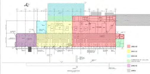
The DEGS (Dublin Electricity Generating Station ) building is further extended Diagram illustrates the various building phases.
The AngloIrish Trade War (Economic War) 1932 - 1938 - shaped Port -
Source: stellamarisrowingclub.com
Stella Maris Rowing Club founded
A dumping agreement is struck between Dublin Port, Dublin Corporation and the Pembroke Estate. Dublin Corporation deposit domestic waste on the southern foreshore of Ringsend, resulting in land reclamation
Source: CHRONOLOGICAL
& ‘The Emergency’ begins
GreatNorthernRailway
begins on the foreshores north of the Great
Wall, as acquired in 17921814. Works include new South Quays and
GreatNorthernRailway
GreatNorthernRailway
Dumping area permitted in the 1937 agreement is
Dublin Port reviews the dumping agreement amidst concern over the Pembroke Estate’s new lands created by this waste. Dublin Port begins negotiations to purchase 650 acres of foreshore south of the Pigeon House Road and Great South Wall
A Tripartite Agreement is formed between ESB, Dublin Port and Docks Board and Dublin Corporation. Lands on the Poolbeg Peninsula are rationalised to suit functional requirements of these bodies.
Completion of Alexandra Quay East
Goulding's jetty
1968 - 1986 Timeline
GreatNorthernRailway
Development of the new South Quay is completed
TICCIH (International Committee for the Conservation of Industrial Heritage) founded
Oil-fired power station opened at Poolbeg. DEGS (Dublin Electricity Generating Station) ceases use as a power station Scott Tallon Walker complete the Port Centre building New East Link toll bridge opens 1971
1986 -Timeline
GreatNorthernRailway
GreatNorthernRailway
Irishtown Nature Reserve opened
Industrial Heritage Association of Ireland established
1995
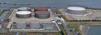
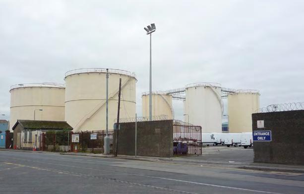
National Oil Reserve Agency (NORA) is established, 1995. Oil tanks are located on Poolbeg Peninsula to meet oil stockholding obligations
S.I. No. 98/1997Harbours Act, 1996 (Limits of Harbour of Dublin Port Company) (Alteration) Order, 1997
Dublin Port Company established
UNESCO publish Historic Urban Landscape guidelines DCC commission the Conservation Plan and Reuse Strategy for Pigeon House Precinct (an action of the City Heritage Plan)
2012 Dublin Port Masterplan
2013 Dublin Port Board passed Soft Values: Alexandra Basin Redevelopment Project
Dublin City Council wind up of Dublin Docklands Development Authority - Planned dissolution 2014, Official dissolution 1st March 2016 Masterplan review; Seville Charter of Industrial Heritage Flour Mill Masterplan launch; Pumphouse
Dublin Dockland Development Agency (DDDA) Established
Dublin Dock Workers Preservation Society Established ICOMOS & TICCIH publish the Dublin Principles
Bell
Dublin Waste to Energy facility (Covanta) begins operation
Dublin Port Distributed Museum
2.4 Current Context
Dublin Port and the City
In a busy and dense Port with ever increasing demands, robust policies are required to ensure a policy of Port-City integration. In October 2013 the Board of the Dublin Port Company adopted a report entitled The Soft Values Project: Strategic Framework as an integral element of its planning and development policy.17 The report outlined, at a high level, a framework that would underpin DPC’s commitment to communicate, celebrate, conserve and promote the multi-layered connections between Dublin Port, Dublin City and the island of Ireland. The Board went further in June 2018 and noted the following: 'The vision is that within ten years, we will have transformed Dublin Port into a highly land efficient port, an attractive destination in its own right and permeable to the people of Dublin to enjoy and experience the Port’s heritage in all its diversity from the natural environment, to arts, to local history'.
The term Soft Values has permeated Port management and practice in recent decades. The term is amorphous but relates to a recognition that intangible human attributes such as sociability, communication skills, empathy and emotional intelligence are, while not readily measurable or quantifiable, deemed essential attributes of a well-functioning organisation. In the context of DPC’s masterplan policies, the term Soft Values can be seen as an homage to a seminal book entitled Soft Values of Sea Ports by the eminent Belgian marine lawyer Erik Van Hooydonk. 18
Van Hooydonk’s avocational passion for re-imagining and realigning the rich, complex and often paradoxical relationships between sea ports, their urban settings and the public has influenced the policies of bodies such as the European Sea Port Organisation (ESPO) of
which DPC is a member. The concept of Soft Values in Masterplan 2040 has now been adopted as Port-City integration.
Intangible assets
Van Hooydonk places the imperative to articulate and nurture the often intangible social, scientific, technological, cultural, economic, ecological and environmental attributes of sea ports - their Soft Values - in a strategic framework predicated on an analysis of the often paradoxical and contradictory relationship between the public and the ever-evolving nature and reality of sea ports globally.
His analysis presents historical testimony that portrays sea ports as the nexus of trade, commerce and transport with crime, warfare, invasion, immigration, corruption, prostitution and pollution, while equally providing testimony to the natural beauty of their settings, their intrinsic amenity value and potential, and legacy in the realms of architecture, engineering, literature, the visual arts, ecologies and community cultures.
Threats of a hostile environment avoided
The threats to the significance of sea ports have undoubtedly been compounded in recent history by ever evolving developments in shipping, the mechanisation of cargo handling, containerisation and security imperatives, which have often rendered port landscapes as being soulless, hostile and inaccessible to the public.
What this highlights in the case of Dublin, along with the broader cultural heritage significance articulated in this Conservation Strategy, is the very small but highly important area of land that exists to protect and enhance the cultural heritage. The Conservation
Starboard Home CD Cover
Source: Dublin Port Archive
Outrage by Fishamble Source: Dublin Port Archive
Strategy proposes the concept, or framework, of ‘The Port City’ as a way to plan and manage the protection and enhancement, while also enabling the Port-City integration objectives of the Masterplan, and allowing ongoing development of Dublin Port.
Interpretation and public engagement
Recent epochs of change inevitably conceal layers of successive administrative and governance structures, redundant infrastructure, and critically generational memory of communal human endeavour, engagement and achievement. In Dublin, the very form, image and experience of the historical city is directly a function of the evolution of the Port, from its origins at Wood Quay to its current configuration.
Since 2015, DPC has engaged in multi-faceted initiatives reflective of its objectives to enhance public engagement with the legacy, heritage and future of Dublin Port and its intrinsic links with the city. These range from the visible and tangible, for example, the Dublin Port Diving Bell on Sir John Rogerson’s Quay, to commissioned art installations, school art projects and innovative musical projects such as Starboard Home, a joint venture with the National Concert Hall.
DPC has supported and subvented research and publication of books relating to Port-City history and, through its ongoing series of public lectures and sponsorship of exhibitions and theatre, is committed to rendering its unique archives accessible to the public.
19 The recent award-winning enhancements of its headquartes building, Port Centre on Alexandra Road, and the rehabilitated Substation, are testimony to its commitment to inviting public engagement while heralding impending increased public access to the Port, which will become manifest over time with the completion of works currently in progress, including the Liffey-Tolka link and Greenway, the future Sea Organ and public space to be constructed at the new eastern breakwater as part of the MP2 project, and the future Odlums Flour Mill Project.
Séan O’Casey Community Centre in Dublin’s East Wall, redesigned garden sponsored by DPC
Source: Dublin Port Archive
Book of Names by ANU and Landmark
Source: Dublin Port Archive
Bindon Blood Stoney’s Diving Bell transformed into a walk-through museum
Source: Dublin Port Archive
Sylvia Loeffler, art piece from her Deep View exhibition at Dublin Port Company
Source: Photograph from exhibition
Access
Safe and meaningful public access to DPC lands and properties presents challenges. The Conservation Strategy articulates how such access could be enhanced and managed. It supports the current initiatives to integrate cycle and walking routes with existing and proposed cycle and walking networks at city and national scale.
The Distributed Museum
The ' Distributed Museum ' is the working title of an initiative by Dublin Port Company to promote awareness and public engagement with physical elements of Port heritage and amenity assets of the Port. The Dublin Port Diving Bell and reconfigured and publicly accessible DPC offices, noted in proposed visitor routes, represent visible testament to its commitment to celebrate and foster Port-City integration. Other projects, whether planned for or in the process of implementation, notably the Liffey-Tolka Project, the Flour Mill Project and the Tolka Estuary Greenway, will in time radically transform the perception and experience of the North Port particularly.
The Distributed Museum is conceived to finish at the Flour Mill, the working title for a project currently underway. This project, centred on the Odlums Flour Mill, will present the city with a unique resource and visitor destination. It will integrate Port operational uses, a National Maritime Archive, two 300-seat theatres, spaces for artists and exhibition spaces.
In summary, current plans and initiatives, when fully realised, can and will transform the perception and experience of Dublin Port and its interface with the city and beyond. (See Distributed Museum map on page 44 and selection of existing and projected Port City attractors map on page 45)
The concept of a Distributed Museum can be integral to the concept of the Port City offered in this document as a strategic planning framework embracing the heritage of the Port and its setting.
Greenways
The Royal and Grand Canals have fortuitously survived as integral and precious elements in the image and experience of Dublin. Both now form parts of Greenways facilitating east-west connectivity on foot or on bicycle, besides providing connectivity to the Shannon and beyond to the Atlantic for boating enthusiasts.
On foot of the MP2 project, a 4/5 km greenway to the North Port boundary will present citizens and visitors with a new and special amenity, offering vantage points over Dublin Bay and the 24/7 operation of the Port. In turn, the proposed Greenway will be integral to the proposed Liffey-Tolka Project, currently in planning.
It is envisaged that the Liffey/Tolka greenway will link to the South Port, via the proposed South Port Access Route (SPAR) Bridge, which will form a key element of the forthcoming 3FM Project.
It is envisaged that dedicated active travel routes will connect the existing (and proposed) pedestrian/cycle network, which will facilitate access to key heritage sites and facilitate access to the Great South Wall via the Nature Reserve.
EuroVelo
EuroVelo, 20 the European cycle network, is an initiative of the European Cyclists’ Federation (ECF) in cooperation with national and regional partners. EuroVelo incorporates existing and planned national and regional cycle networks into a single European network. It currently comprises 17 routes totalling 90,000 kilometres. Dublin Port, and specifically its existing and planned Greenways and Active Travel Routes, offers a destination and point of embarkation on, for example, the cycleway linking Dublin and Galway, and other evolving routes. As a party to the EuroVelo project, DPC can assist in promoting cycling and sustainable travel in conjunction with national and regional governments, state bodies and NGOs.
Tram system
The 3FM Project proposed by Dublin Port Company will provide a reservation to facilitate a possible future LUAS connection to the Poolbeg Peninsula, which in turn will connect to the proposed network of active travel routes.
Connectivity
The legacy of connectivity by canal and rail to Dublin Port is indelibly imprinted in the form and experience of Dublin City, and on the form and character of the midland towns of Ireland. As Dublin Port Company commits to the phased delivery of its key Masterplan objectives, it will seek to integrate their evolution with public transport initiatives, cycling and walking networks, and use of the river channel to enhance the public’s engagement with the Port’s
Dublin Port entrance design
Source: Dublin Port Company, copyright Enda Kavanagh
Concept re-design of East Wall Road at Dublin Port
Source: Grafton Architects for DPC
Concept design for the Flour Mill Masterplan Source: Grafton Architects for DPC
cultural and natural heritage. Such transport tendrils create the links between the main features of the Port City that exist within and adjacent to the Port Estate.
Over time, the Poolbeg Peninsula hosted emerging energy generating facilities and sewage disposal infrastructure. It continues this role as Metropolitan Utilities Hub to the present day, with the upgraded sewage treatment plant and the recent Waste to Energy facility. A great deal of the land on the Poolbeg Peninsula is of recent vintage, with multiple ownerships. However, there are two significant heritage assets that form part of the 'Port City' concept - The Great South Wall and Pigeon House Precinct. Pigeon House Precinct is understood to be the area comprising the former Pigeon House Fort. This includes the surviving structures and form of the historic Fort, along with the later municipal outfall works and Pigeon House generating station. It can be expanded to include the 1970s Poolbeg Generating Station with its iconic chimneys. Much of this significant heritage lies outside the ownership of Dublin Port Company.
Retaining the Significance of GSW as pedestrian amenity
The recent pandemic illustrated starkly how integral elements of the Port’s heritage are to the recreational patterns of citizens of Dublin. Dublin Port Company recorded approximately 180,000 visitors passing the Half-Moon Battery over the 12-month period, March 2021-22.
The Port’s aim is to facilitate recovery of legibility and public access to the GSW, recognising this is a long term strategy, potentially looking beyond the lifetime of the 2040 Masterplan. While full physical access across the full length of the GSW may be limited by existing constraints, future opportunities to improve access could be integrated within Port development at all scales with an aim to avoid further loss of access.
Port City
The Port City concept, is offered by the consultants working on behalf of DPC as a strategic framework that is in line with ESPO policies to encourage good and sustainable port-city relationships. The Port City concept recognises the totality of Dublin Port’s and Dublin Bay’s rich culture, natural heritage, past present and future. It presents Dublin with an eastern ‘Pole’ counterpointing the Phoenix Park to the west. Within the lands owned by Dublin Port, heritage assets will be visitable by the public in an environment that also has
necessary restrictions for safety and operational reasons.
However, the Port City concept is offered to embrace not only the heritage and amenity assets of Dublin Port but also those of adjoining landholdings and Dublin City Council. In this context, the concept offers the potential for collaboration in protecting heritage while inviting stewardship and partnership in the development of safe active travel routes, canals and campshires that connect to the city and beyond, including the Royal Canal Urban Greenway.
The concept will offer other landowners, local authorities, operators and interest groups an opportunity to collaborate in maximising the quality of public access, engagement and enjoyment.
Creative and collaborative actions could over time nurture the Port City to become a destination of national and international significance, and an exemplar of sustainable development. The Port City concept considers cultural heritage not as a fossil, but as part of a dynamic port where the public can explore and understand the diverse heritage of 300 years of port history, particularly the engineering achievements of the past in the context of present and future environmental and technical challenges. Shared ownership of the concept should also induce collaboration and stewardship.
The concept presents itself as a means of protecting an important Heritage Urban and Maritime Industrial Landscape consistent with UNESCO principles. It is a robust policy for the protection of key heritage resources, an important objective in an expanding port that will deliver 73.8 million tonnes annually by 2040.
The Port City integrates the following policies and concepts:-
• Soft values identified in the Masterplan 2040
• The Dublin Port Distributed Museum
• The Pumphouse Heritage Area
• The Flour Mill Masterplan
• Greenways, Liffey-Tolka link – rail and cycle links and active travel routes
• The Aeolian Harp/Sea Organ
• The Pigeon House Precinct (not in DPC ownership)
• The Port Precinct (including The Substation)
• The Great South Wall
Concept design for the Aeolian Harp and Sea Organ, as part of MP2
Source: MOLA for DPC
Concept design for the North Port Greenway
Source: ROD/ Redscape for DPC
The concept is proposed to align with the Historic Urban Landscape approach, which derives from the 2011 UNESCO Recommendation on the Historic Urban Landscape (HUL). It also embraces the ICOMOS – TICCIH Principles for the conservation of Industrial Heritage Sites, Structures, Areas and Landscapes (the Dublin Principles).
Port City is in line with ESPO's initiatives to encourage Ports to be the managers around societal integration, advancing and maintaining good relationships between all stakeholders and creating a port culture of trust. Alongside the initiatives associated with cultural heritage that are the focus of this Conservation Strategy, DPC's environmental policy has invested in air quality monitoring, bird watch monitoring and marine monitoring buoys to better understand the dynamics of the Port's natural environment and to safeguard its heritage above and below the waterline.
DPC's approach to the 'Port City' concept is also in line with the goals of the Association of International Ports (AIVP) set out in AIVP Agenda 2030, which helps port and urban stakeholders to prepare projects and plans that contribute to sustainable development and port-city relationships, as summarised on pages 128-129 of this document. The AIVP topic on port city interfaces with the Sustainable Development Goals (SDG) of Quality Education (SDG 4) and Sustainable Cities and Communities (SDG 11).
A distinct and relatively small area has been identified as the ‘Port City’ together with appropriate policies to enhance the existing natural and cultural heritage of the Port. The proposed enhanced heritage landscape will provide a carefully designed, localised relaxation from development pressures which are required by the Masterplan 2040 and give a greater understanding and enjoyment of a historic working port.
The proposal aims to acknowledge and interpret, through access, use, recovery and other mechanisms, the combined importance and influence of the many diverse forces which have shaped the Port and continue to do so.
These include:
• The geomorphology and hydrology of the bay, especially the role of the North Bull wall.
• The engineering achievements of Bindon Blood Stoney in creating the nineteenth-century ‘Deep Water Port’ and the achievements of the Ballast board in the eighteenth century in creating, at the time, the longest breakwater in the world.
• The achievements of electricity generation and usage, particularly at Pigeon House generating station which became a world model.
• The surviving built structures and infrastructure, including harbours; berths; basins; bridges; slipways; graving docks; warehouses, grain silos; military/defence structures; power stations; water and waste treatment plants; hospital; hotel.
• The economic role of Dublin Port to city and state including canal systems, rail networks, lighthouses, navigation aids and Liffey bridges.
• The cultural influences: trade, food, language, names, architecture, fashion, events and histories, industries and businesses.
• The activities on the Port Estate such as the Half Moon swimming club, the boat clubs, the walkers, together with the history of shipwrecks and other histories to be uncovered and spoken.
To counterpoint the Phoenix Park with the ‘Port’ and other land uses, prompts a concept that is offered as a strategic framework within which Port Development and public engagement can be reconciled and planned for.
The concept recognises that the unique cultural and natural attributes, history, heritage and amenity value of the Port and its setting in Dublin City and Dublin Bay offers citizens and visitors an eastern pole to the Phoenix Park.
The ’Port City’ concept, underpins DPC’s commitment to Port-City integration and will facilitate visits to certain parts of the Port, on a pre-arranged basis, which would not normally be accessible for operational and security reasons.
The ‘Port City’ concept will offer other landowners, local authorities, operators and interest groups an opportunity to collaborate in maximising the quality of public engagement and enjoyment, particularly on the Poolbeg Peninsula.
Creative and collaborative actions could over time nurture ‘Port City’, to become a destination of national and international significance, and an exemplar of sustainable development.
The threats to the cultural significance of sea ports, particularly taking into account the density of Dublin Port discussed in Chapter 1, have undoubtedly been compounded in recent history by everevolving developments in shipping, the mechanisation of cargo handling, containerisation and security imperatives, which have often rendered port landscapes as being soulless, hostile and inaccessible to the public. The ‘Port City’ aims to provide the public and tourists with a creative experience.
Land Connectivity to the Port- Existing and Planned
2.5 Cultural Heritage Policy Context- Statutory and Non-Statutory
1. Cultural Heritage Policy Context – Statutory and NonStatutory
The primary focus of the Conservation Strategy is on the tangible archaeology and built heritage of Dublin Port. Intangible dimensions are also addressed in so far as they relate to, or are manifest in, the physical domain.
Development and management of this heritage is guided and governed within a policy context that includes both statutory and non-statutory components. The present section sets out the key policies that relate to the tangible archaeological and built heritage. The National context is described first as it contains the primary legislative provision for this heritage. It is followed by the local context – the Dublin City Development Plan being the relevant statutory document – but also includes the Dublin Port Masterplan 2040 , which underpins this Conservation Strategy, along with other influencing non-statutory material.
Finally there are a number of international documents which, while principally voluntary in nature, set out best practice approaches to conservation management and planning and bear directly on this Plan and its implementation.
2. National
National Monuments Acts 1930 to 2014, Historic and Archaeological Heritage and Miscellaneous Provisions Act 2023
The National Monuments Acts and the Historic and Archaeological Heritage and Miscellaneous Provisions Act 2023 are designed to
provide statutory protection to archaeological features, structures and artefacts that exist above and below the ground, on land and under water. The National Monuments Service maintains the Sites and Monuments Record (SMR), the Record of Monuments and Places (RMP) and the Historic Shipwreck Inventory as the statutory registers for recorded archaeological sites, while recorded artefacts are registered in the Topographical Files of the National Museum of Ireland. It is a requirement of the National Monuments legislation that any works at or in relation to a Recorded Monument or a Registered Monument must be notified in writing to the Minister two months before commencing that work. This is to allow the National Monuments Service time to consider the proposed works and how best to proceed to further the protection of the monument. Such works, and proposed works in areas where there are no recorded monuments, may also be subject to archaeological licensing and other consent requirements that provide for the correct observation, recording and reporting of cultural heritage assets. The provisions under the National Monuments Acts support proposals where the mitigation strategy is to avoid and minimise impacts on and at recorded sites.
The following guideline documents outline the manner in which archaeological assessment and mitigation is recommended under the existing acts. Framework and Principles for the Protection of the Archaeological Heritage (1999); Advice to the Public on Ireland's Underwater Archaeological Heritage (2023); Archaeology and Flood Relief Schemes: Guidelines (2023).
Planning and Development Acts 2000 to 2021
Part IV of the Planning and Development Act 2000 provides for the statutory protection of structures, namely Protected Structures,
which are a reserved function of Local Authorities. Each Local Authority is required to have a Record of Protected Structures (RPS). Part IV also includes for the designation of Architectural Conservation Areas, again a reserved function. All archaeological sites are protected structures. However not all architectural heritage sites are protected, and nor are all industrial heritage sites.
The implications of protection are that planning exemptions which normally apply to non-protected structures, may not necessarily apply to a protected structure. Development that has the potential to materially alter the special interest character of a protected structure, its curtilage and/or structures within its attendant grounds, will require planning permission. Section 57 of the Act provides a mechanism for Local Authorities to declare those works that would materially alter the protected structure, and thus require planning permission, and those that would not materially alter the protected structure and do not require planning permission. A Declaration 57 application can be sought and issued without any specific development proposals. Clarity regarding exemption can also be sought under a standard Section 5 Exemption application, normally applied for in the situation of specific proposals.
Another notable aspect of this legislation is that demolition of a protected structure is only permissible in exceptional circumstances. It also places the responsibility for safeguarding the protected structure on the owner and/or occupier and gives powers to the Local Authority to issue an Endangerment Notice on the owner/ occupier requiring specified safeguarding works to be carried out within a set time. Where this is not complied with, the Local Authority can carry out the works themselves and recover costs of same. The Act also grants Compulsory Purchase Order powers to
the Local Authority.
The Architectural Heritage (National Inventory) and Historic Monuments (Miscellaneous Provisions) Act, 1999, sets out the mechanism for assessing a structure and identifies eight criteria of special interest that a protected structure, a specified part of a structure or a specified feature of the attendant grounds possesses that warrant statutory protection. These eight criteria are –Architectural; Historical; Archaeological; Artistic, Cultural; Scientific; Social and Technical.
This Act defines the importance ratings and how these are applied in the assessment of structures. The ratings comprise: International; National; Regional; Local; Record Only. Any structure rated as of regional or greater importance is automatically conferred with a Ministerial recommendation for inclusion on the Record of Protected Structures.
Architectural Heritage Protection Guidelines for Planning Authorities (2011)
These statutory Guidelines were issued under Section 28 of the Planning and Development Acts and the latest update of the Guidelines dates to 2011. It is a comprehensive Guidance document which is primarily addressed at Planning Authorities – which include An Bord Pleanála, as well as Local Authorities.
National Planning Framework 2040
A key future growth enabler for Dublin, which also aims to provide high quality international connections, the National Planning Framework (NPF) provides for:
Facilitating the growth of Dublin Port through greater efficiency, limited expansion into Dublin Harbour and improved road access, particularly to/from the southern port area.
One of seven National Strategic Outcomes is ‘ Enhanced Amenity and Heritage’ , and one of ten strategic investment priorities is ‘Culture, Heritage and Sport’ . Arts, culture and heritage are listed as ‘Elements Supporting Quality of Life’
Chapter 7: Realising our Island and Marine Potential, states the following:
Our marine environment is a national asset that yields multiple
commercial and non-commercial benefits in terms of, for example, seafood, tourism, recreation, renewable energy, cultural heritage, and biodiversity.
As regards energy strategy, the NPF 2040 highlights cultural heritage as a consideration, as follows:
In the energy sector, transition to a low carbon economy from renewable sources of energy is an integral part of Ireland’s climate change strategy and renewable energies are a means of reducing our reliance on fossil fuels. The forthcoming Renewable Electricity Policy and Development Framework will aim to identify strategic areas for the sustainable development of renewable electricity projects of scale, in a sustainable manner, compatible with environmental and cultural heritage, landscape and amenity considerations. The development of the Wind Energy Guidelines and the Renewable Electricity Development Plan will also facilitate informed decision making in relation to onshore renewable energy infrastructure.
National Landscape Strategy 2015-2025
The National Landscape Strategy was developed and adopted following Ireland’s ratification in 2002 of the European Landscape Convention. Article 1.a of the European Landscape Convention defines landscape as meaning an area, as perceived by people, whose character is the result of the action and interaction of natural and/or human factors. As a reflection of European identity and diversity, the landscape is further defined as including living natural and cultural heritage, be it ordinary or outstanding, urban or rural, on land or in water. Landscape thus embraces towns, cities, villages and seascapes.
National Marine Planning Framework (Project Ireland 2040)
This provides an integrated approach for planning the marine environment. It sits within the Harnessing our Ocean Wealth Maritime Policy, with cultural heritage an important component of this wealth. Established in May 2021 it situates heritage assets as part of the social infrastructure. Heritage Assets Planning Policy 1 states the following:
Proposals that demonstrate they will contribute to enhancing the significance of heritage assets will be supported, subject to the outcome of statutory environmental assessment processes and subsequent decision by the competent authority, and where they
contribute to the policies and objectives of this NMPF. Proposals unable to contribute to enhancing the significance of heritage assets will only be supported if they demonstrate that they will, in order of preference: a) avoid, b) minimise, or c) mitigate harm to the significance of heritage assets, and d) if it is not possible to mitigate harm, then the public benefits for proceeding with the proposal must outweigh the harm to the significance of the heritage assets. (Public Benefits are defined in the NMPF Glossary).
The NMPF provides a Seascape Character Area and Coastal Types appraisal of Ireland’s coast, describing Dublin Bay seascape as a ‘Modified Historic Urban Bay’.
Heritage Ireland 2030
This provides a framework for the protection, conservation, promotion and management of Ireland's heritage that is built on three over-arching themes: Communities and Heritage; Leadership and Heritage, and Heritage Partnerships.
Built and Archaeological Heritage, Climate Change Sectoral Adaptation Plan
Prepared in 2019 under the National Adaptation Framework, the strategy aims to: build adaptive capacity, reduce the vulnerability of built and archaeological heritage to climate change, and identify and capitalise on the the various potential opportunities in the sector.
Natural Heritage Policy
While the Conservation Strategy does not deal directly with the natural heritage aspects of Dublin Port, it is recognised that there is a substantial statutory framework for protection of natural heritage (wildlife and biodiversity) applicable within Dublin Port. This sits within the EU Directives (Habitats, Birds) and National Wildlife Acts 1976-2021, which provide for the Special Areas of Conservation, Natural Heritage Areas, and Special Protection Areas within and adjacent to the Dublin Port Area. These are set out further in Section 2.7.
In some instances there can be perceived conflicts between the objectives of the cultural heritage and natural heritage policy. However, it should also be observed that the interaction between nature and culture has shaped the character of Dublin Port. Many sites of cultural heritage significance within the Port also
support natural heritage. Therefore, in considering Dublin Port as a ‘landscape’ (cultural, maritime), it is possible to address its management in a holistic, integrated approach. Such an approach is in keeping with the direction in which heritage policy is moving internationally.
3. Local
Dublin City Development Plan 2022-2028
The key statutory policy at the local level is the Dublin City Development Plan, excerpts of which are referenced in the following pages.
While Chapters 11 Built Heritage and Archaeology and 12 Culture, address cultural heritage directly, the Plan contains other relevant Objectives and Policy. The following sets out in sequence those that are of greater relevance to this Conservation Strategy.
Chapter 4: Shaping the City
Dublin City Council fully supports and recognises the important national and regional role of Dublin Port in the economic life of the region and the consequent need in economic competitiveness and employment terms to facilitate port activities. Dublin Port will have a significant role to play in the future development and growth of the city and it is considered prudent to plan the structure of this part of the city, including the proposed public transport network, to fully integrate with the developing city structure and character, while having regard to the Dublin Port Company Masterplan 2012-2040
SC7: states It is the Policy of Dublin City Council to support and recognise the important national and regional role of Dublin Port in the economic life of the city and region and to facilitate port activities and development, having regard to the Dublin Port Masterplan 2012-2040.
Chapter 6: City Economy and Enterprise
Here Dublin Port is recognised as a particularly important element of the city’s transportation and logistics infrastructure, captured in Policy CEE35, which states:
It is the Policy of Dublin City Council to recognise that Dublin Port is a key economic resource and to have regard to the policies and objectives of the Dublin Port Masterplan including the reintegration of the Port with the City.
Survey of the Bay of Dublin by Captain William Bligh, 1800
Source: Dublin Port Archive
Chapter 10: Green Infrastructure and Recreation
Objective GI033 sets out the objective for Dublin City Council to liaise and work with other state agencies responsible for the city’s waterways, including Dublin Port.
This section also addresses the Dublin Bay UNESCO Biosphere, designated in 2015. There are several Objectives (GI135; GI 136; GI137; GI138, & GI139) and Policies (GI037; GI038, & GI039), aimed at protecting, managing, interpreting, promoting and enabling public engagement with the Dublin Bay Biosphere, some of which involve Dublin Port.
Chapter 11: Built Heritage and Archaeology
This section contains specific measures which directly relate to Dublin Port, and several relevant objectives and policies which more generally relate to archaeological, built and industrial heritage.
Policy BHA33 Dublin Port Heritage Quarter , is to support the vision of the Dublin Port Company for the Flour Mill and surrounding heritage assets of the Port to deliver a new cultural heritage quarter and maritime museum for the city, that documents Dublin’s rich maritime history and the social history of the dock workers.
The following objectives and policies, while generally applicable, are relevant to the Conservation Strategy:
BHA1; BHA2; BHA3; BHA4; BHA5, and BHA6 all address protected structures, or structures recommended for protection, and address aspects such as their development and restrictions on demolition. Dublin Port Estate has a rich collection of recorded monuments and structures of archaeological, architectural and industrial heritage interest. The registers are continually being updated.
Objective BHA1 states that Dublin City Council will maintain and proactively manage a Buildings-at-Risk register of Protected Structures considered endangered or with potential to become so.
BHA9 defines the Policy for Conservation Areas. These are locally designated areas as distinct from the statutory Architectural Conservation Areas provided for within Part IV of the Planning and Development Act. Dublin Port contains areas with such designation – the eastern section of the Great South Wall (the section currently publically accessible); the Pigeon House Harbour and former Power Station area (not in DPC ownership); the Liffey entrance to
Grand Canal Dock (the entire dock area is designated) (not in DPC ownership). While just outside Dublin Port, the Liffey Quays and campshires running west from Thomas Clarke (East Link) bridge are also designated Conservation Areas.
Policy BHA11 sets out policy seeking retention and, where appropriate, rehabilitation of existing older buildings/structures/ features which make a positive contribution to the character of an area – preferring retention rather than demolition.
BHA 12 and 13 set out policy relating to industrial, military and maritime heritage, and maritime villages. There is further policy regarding industrial heritage in BHA16 and BHA17, with an objective (BHA08) to add industrial heritage sites to the RPS.
Policy BHA15 addresses twentieth-century buildings and structures:
(a) To encourage the appropriate development of exemplar twentieth century buildings and structures to ensure their character is not compromised
(b) To encourage the retention and reinstatement of internal and external features that contribute to the character of exemplar twentieth century buildings, such as roofscapes, boundary treatments, fenestration pattern, materials, and other features, fixtures and fittings (including furniture and art work) considered worthy of retention.
This Policy is supported by BHA06 an objective to identify and protect exemplar buildings of the twentieth century, including where appropriate, to add to the RPS and to produce guidelines and advice for their protection and appropriate refurbishment.
Historic ground surfaces, street furniture and public realm are considered under Policy BHA18 which refers to the national Advice Series on ‘Paving. The Conservation of Historic Surfaces’ (2015). BHA20 is a policy aimed at retention and maintenance of heritage signs and advertising (Ghost Heritage Signs).
There are several objectives and policies aimed at reuse, refurbishment, retrofitting and measures to address sustainability and enhance energy efficiency of built heritage – BHA21, BHA22, BHA23, BHA24.
Chapter 11 also sets out objectives and policy relating to archaeological heritage.
Of these, BHA26-Archaeological Heritage is key in setting out statutory policy relating to the sites and zones of archaeological interest identified in the Record of Monuments and Places and the Historic Environment Viewer (ref www.archaeology.ie). This policy adopts a priority for protection of archaeological material in situ by ensuring that only minimal impact on archaeological layers is allowed; to seek preservation in situ where possible; to consult with the City Archaeologist; carry out archaeological assessment, and have regard to national policy documents and guidelines relating to archaeology and best practice. It also requires development in marine, lacustrine and riverine environments and areas of reclaimed land to have regard to the Historic Shipwreck Inventory (Dept of Housing, Local Government and Heritage).
Chapter 12: Culture
Chapter 12 refers to the above Policy BHA33 as it relates to the Plan’s vision to add to existing cultural venues within the Docklands area. In addition Chapter 12 contains the following objective for the Poolbeg Harbour and Power Station Complex (part of the area described as the Pigeon House Precinct in the Conservation Strategy, and within the ownership of Dublin City Council):
Objective CU020 Poolbeg Hotel, Harbour and Power Station Complex
Support the development of the historic Poolbeg hotel, harbour and power station complex for an innovative cultural enterprise that will provide a sustainable future for these historic riverside buildings and provide a range of new facilities for this area of the city.
Chapter 12 contains a number of other policy and objectives which have relevance to Dublin Port Conservation Strategy:
CU12: Cultural Spaces and Facilities: To grow the range of cultural spaces and facilities in tandem with all new developments and across existing developments to meet the needs of an increased population within the city.
CU16: Temporary Use for Cultural Provision: To facilitate the temporary use of underused sites or buildings for artistic or cultural provision.
Objective CU027: Artist Studios: To further develop and provide spaces for artist studios within the city and avail of opportunities for utilising underused buildings within communities for artistic and cultural purposes.
Objective CU031: Music Venues: To encourage the development of new music venues that will provide opportunities for music artists to perform at a range of venue sizes.
Chapter 13: Strategic Development Regeneration Areas
This chapter again acknowledges the Masterplan 2040 – To recognise the significance of Dublin Port Company’s non-statutory 2040 Masterplan, and related updates/reviews, as an important guiding document for the future of Port lands, as well as the Dublin Port lands which form part of the 2019 Poolbeg West Planning Scheme.
The Dublin City Development Plan 2022-2028 also sets out development standards to be applied to any new development. It lays down the land-use zoning objectives for the Dublin Port area, including those owned by Dublin Port Company and others, along with the uses that these zonings permit. Within the Dublin Port area there are a number of designated Seveso Sites. Seveso Sites are defined as industrial sites that, because of the presence of dangerous substances in sufficient quantities, are regulated under Council Directives 96/82/ECand 2003/105/EC, commonly referred to as the Seveso II Directive. Certain uses, such as residential type uses, within a defined distance of these sites will not be permitted.
The Dublin Port Masterplan 2040
This non-statutory plan underpins and guides the ongoing management and development of Dublin Port across its historic footprint and is a key policy document which frames the Conservation Strategy. The Masterplan provides the mechanism for accommodating the increase in port capacity by modernising land use. It also ensures the reintegration of the Port with the City and with Dublin Bay by means of projects and initiatives based on the Port’s heritage and on the natural environment. The maritime industrial use of the Port lands over several centuries provides the natural historical context and narrative, and DPC’s initiatives continue to celebrate and make known these often hidden and forgotten histories that remain at the core of Dublin’s identity, past, present and future. Where operational considerations from
the late nineteenth century created boundaries between Port and City, current port policy celebrates the connectivities in line with international best practice, and the Masterplan is instrumental in acknowledging how DPC can play its role in reintegrating Port and City, by acknowledging, protecting and celebrating its tangible and its intangible heritage assets. Refer to section 2.4 for examples of these initiatives.
The Masterplan aligns with sustainable development principles and practice, and includes the following key environment and heritage objectives:
Ensure a development framework that is compatible with adjoining areas; integrate new development with the adjacent built and natural heritage; promote sustainable development; secure the preservation of all protected structures within the Port Estate; Promote accessibility; achieve excellence in quality design.
The Dublin City Development Plan also has regard to the Dublin Port Masterplan, explicitly within Chapter 4, 'Shaping the City', and Chapter 5, 'City Economy and Enterprise', thus embedding it within statutory local planning policy.
Fáilte Ireland
Fáilte Éireann has developed a plan, ’Docklands Experience Development Plan’, 2020, to promote the diverse attractions of the Docklands and Dublin Port as an integral element of Dublin’s attraction to domestic and international tourists. The plan is ambitious and anticipates the promotion of such attractions as the Flour Mill project. Continued dialogue and collaboration between DPC and Fáilte Éireann is recommended.
Dublin City Industrial Heritage Record (2006, 2009)
The DCIHR identified a number of existing and former structures within Dublin Port areas being of industrial heritage significance and these are set out in Chapt er 3.2 . While these are not statutory designations, nonetheless Policies BHA16-Industrial Heritage and BHA17-Industrial Heritage of Waterways, Canals and Rivers of the Dublin City Development Plan 2022 endows some status of protection.
4. International Guiding Policy
Essentially voluntary in nature, there is a raft of significant international text – charters, conventions, principles, guidance, recommendations – that provide an important guiding platform for the management and development of places of cultural heritage significance and establishing accepted best practice internationally and nationally.
The more directly applicable of these are listed below under themes of relevance to Dublin Port.
Foundational Charters
• International Charter for the Conservation and Restoration of Monuments and Sites (The Venice Charter) - 1964
• Charter for the Conservation of Historic Towns and Urban Areas (The Washington Charter) - 1987
• Charter for the Protection and Management of the Archaeological Heritage - 1990
• Charter on the Protection and Management of the Underwater Cultural Heritage - 1996
• UNESCO Convention on the Protection of the Underwater Cultural Heritage - 2001
Other Guidance relevant to Dublin Port as Cultural/Historic Urban Landscape; as Industrial Heritage
• 2011 UNESCO Recommendation on the Historic Urban Landscape (https://whc.unesco.org/en/hul/)
• The Nizhny Tagil Charter for The Industrial Heritage (https:// www.icomos.org/18thapril/2006/nizhny-tagil-charter-e.pdf )
• Joint ICOMOS – TICCIH Principles for the Conservation of Industrial Heritage Sites, Structures, Areas and Landscapes (the ‘Dublin Principles’), 2011
Conservation Strategy
Guidance on Conservation Strategies for Places of Cultural Heritage Significance
• The Australia ICOMOS Charter for the Conservation of Places of Cultural Significance - (The Burra Charter) (Australia ICOMOS)1981, updated in 2013
Charters and Conventions relating to Intangible Cultural Heritage
• UNESCO Convention for the Safeguarding of the Intangible Cultural Heritage, 2005 (https://ich.unesco.org/en/ convention), ratified by Ireland in 2015
The Sustainable Development Goals 2030
• Developed by the United Nations and in force since 1st January 2016, the Sustainable Development Goals (SDGs) are 17 interlinked global goals designed to be a blueprint to achieve a better and more sustainable future for all. They are a means of guiding all plans and actions towards this objective.
The European Sea Ports Organisation (ESPO) ensures that sea ports have a clear voice in the European Union, and supports its sustainable development committee that considers Climate Change; Energy Transition; Environmental Management in Ports; Port development/planning and nature conservation; Pollution, and Ecoports. DPC’s environmental management of the ABR project has created a robust and comprehensive baseline monitoring programme of the natural heritage resources that exist within the Liffey channel and out into Dublin Bay, and these studies are continuing through MP2 and form integral elements for 3FM, ultimately providing a wealth of information that will be useful to the scientific community for decades to come and will inform local, national and international studies on environmental health and well-being. DPC’s commissioning of this Conservation Strategy will support Port development/planning in providing a framework for incorporating the Port’s significant cultural heritage assets in its development projects and day-to-day port management.
The AIVP is an NGO that focuses on bringing together urban and port stakeholders and their partners around the world. Dublin Port Company represents Irish ports. Among AVIP's ten commitments for sustainable action are: Port culture and identity, which promotes the specific culture and identity of port cities and encourages residents to develop a sense of pride as part of a city port commmunity; and
Port City interface, which supports initiatives to provide citizens living in proximity to port activities with housing, recreational and cultural amenities in the city port interface zones. This includes revising the status of port heritage to properly reflect the site's historical significance.
DPC has created an important walk-through maritime museum by adaptive reuse of the Bindon Blood Stoney Diving Bell, now standing on Sir John Rogerson’s Quay. It is facilitating the re-integration of Port and City by creation of the open entrance plaza at Port Centre, imbued with strong maritime themes in its architecture and design. The Tolka Greenway, when linked to the Liffey-Tolka Project, will allow pedestrian and cycle access along the edges of north Port lands, and promote access into the Port itself where the repurposing of Pumphouse No.1 as an artistic and cultural venue located in the heart of Alexandra Basin is the first stage in adaptive reuse of the former graving dock precinct, and will be augmented by the significant repurposing of the adjacent historic granary silos – the Flour Mill project. Cultural reflection and revitalisation will sit alongside the operational activities of one of the city’s principal economic hearts.
2.6 Dublin Port Masterplan and Rising Tides
Dublin Port Masterplan 2040 ’s vision is to transform Dublin Port into a highly land efficient port, an attractive destination in its own right and permeable to the people of Dublin to enjoy and experience the Port’s heritage in all its diversity, from the natural environment, to arts, to local history. The Dublin Port Masterplan 2040 , revised 2018, sets out Dublin Port Company’s (DPC) approach to achieving this vision. At its core, the Masterplan aims to maximise the throughput on the Port’s fixed brownfield land area before seeking to develop additional port capacity at another east coast location. DPC has published the detailed thinking behind this approach in The Dublin Port Post 2040 Dialogue Papers. 21
DPC is in the process of bringing forward a number of projects to planning from its Masterplan to achieve the Port’s ultimate capacity of 73.8 million tonnes of cargo throughput per annum by 2040. This development has focused, to date, on the north side of the River Liffey and at Dublin Inland Port.
On the north side of Dublin Port:
• The ABR Project is largely completed and works on the final stages are underway. 22
• The MP2 Project has commenced. 23
• The project to redevelop the Port’s internal road system is largely completed and work is underway to complete a network of cycle and pedestrian routes throughout and on the periphery of the Port. 24
At the 44 hectare Dublin Inland Port:
• Full planning permission has been granted for one site of 22 hectares. 25
• The first of nine plots has been developed and is in operation to provide capacity for port-related but non-core activities which have been removed from Dublin Port to meet one of the objectives of DPC’s Franchise Policy. 25
• Plans for the development of the second 22-hectare site for the transit storage of trailers and containers are in preparation.
DPC’s focus of attention now is to plan for the completion of the Dublin Port Masterplan 2040 by bringing forward the 3FM Project, the Third and Final Strategic Infrastructure Development project, to:
• Provide c. 20% of the capacity for freight required in the unitised modes (Ro-Ro and Lo-Lo) that will be needed by 2040 on the almost one fifth of Dublin Port’s lands located on the Poolbeg Peninsula.
• Complete the development of Dublin Port’s overall road network to remove much of the traffic from East Wall Road and Tom Clarke Bridge.
• Complete a series of public realm, heritage and active travel projects on the Poolbeg Peninsula which mirror similar developments on the north side of the port to meet the Dublin Port Masterplan 2040 ’s second objective to integrate Dublin Port with Dublin City.
In developing the strategic infrastructure developments outlined above, climate change adaptation is at the core of providing sustainable development in a world that is witnessing unprecedented global temperature and sea level rises.
A significant portion of the additional heating of the planet has been taken up by the world’s oceans, leading to a noticeable change in the global weather systems, leading to:
• Changes in rainfall patterns
• Higher category hurricanes, typhoons and storms
• Melting of sea ice, particularly in the North Polar region, which increases the heat absorption by the sea in this region
• Possible reduction in ocean currents such as the Gulf Stream due to increase in fresh water from melting ice
• Significant increases in sea level and wave activity
The Office of Public Works (OPW) recommends two future climate scenarios with respect to increasing tidal levels:
• Medium Range Future Scenario +0.50m by 2100
• High End Future Scenario +1.00m by 2100
Measurements undertaken by Dublin City Council in recent years suggest Dublin will need to adapt to the High End Future Scenario of a one metre sea level rise by the year 2100. Towards this end, DPC has been planning for this eventuality, building flood adaptation and flood resilience measures into infrastructure design and Port operations.
Notably, DPC is aware of the inevitable impact of sea level rise on the Port’s primary flood defence breakwaters, the Great South Wall and the North Bull Wall. Among the measures being considered to protect them, plans are being advanced at an early stage to potentially raise the height of these historic structures at some point in the future to ensure their continued function while maintaining their integrity, heritage status and a place of heritage value for the people of Dublin to walk and enjoy.
The Harbour of Dublin from the Lighthouse to the city, 1792, Fisher
Source: Dublin Port Archive
Source:
2.7 Cultural Heritage and Natural Heritage
The Dublin Port Masterplan 2040 states DPC’s commitment to work with habitat and nature interests to ensure that the full resource which these habitats and areas provide for wildlife and for the wider public in Dublin are managed, controlled and supported. DPC has sought to establish co-operation agreements with nature interests including NGOs, which involves the provision of access, some element of funding and support to these groups. Two examples are given below.
Dublin Bay Birds Project
The first such agreement was reached in 2013 with BirdWatch Ireland (a national NGO) to fund a long-term project, entitled the Dublin Bay Birds Project. The project involves a professional team of ornithologists carrying out a range of survey and monitoring schemes that cover the entire area of Dublin Bay from Dun Laoghaire to Sutton. The project has continued to add considerable value to existing knowledge on the distribution and movements of water birds.
Dublin Bay Biosphere
Biospheres are places where nature and culture connect. They are internationally recognised for their biodiversity yet also actively managed to promote a balanced relationship between people and nature. A Biosphere is a special designation awarded by UNESCO but managed in partnership by communities, NGOs and local and national governments.
DPC actively participates in the management of the North Bull Island Biosphere, which was expanded in 2015 to cover Dublin Bay, reflecting its environmental, economic, cultural and tourism importance. DPC provides support for:
• Conservation: protecting biodiversity and cultural diversity
• Development: fostering a sustainable economy and society for people living and working in the area
• Learning: facilitating education, training and research to support conservation and sustainable development
The implementation of the next phase of the Dublin Port Masterplan continues to focus on achieving proper planning and sustainable development through the continued re-development of existing ‘brown field’ sites, within the Dublin Port estate for direct Port related facilities, and the transfer of non-critical operations to new facilities located close to Dublin Airport (Dublin Inland Port). DPC confirms that further deepening of Dublin Port navigation channel and fairway to lower than -10.0m CD will not be required. These decisions taken by DPC will significantly reduce the potential environmental impact of the next implementation phase of the Masterplan.
Notwithstanding the approach being adopted by DPC to safeguarding the environment, as described above, there are a number of key environmental issues identified in the Masterplan that DPC is actively addressing:
• The management of the tern colonies located on the existing ESB Dolphin, which is designated a Special Protection Area, and the CDL Dolphin, which is the only colony in Dublin Port that hosts both Common and Arctic Terns. DPC has enhanced the breeding opportunities by providing additional habitat using floating pontoons
• The potential to improve fisheries management within the inner Liffey channel
• The potential to enhance biodiversity in line with the Dublin City Biodiversity Action Plan 2021-2025 . Towards this end, DPC is committed to providing a shared cycle and pedestrian facility that also provides an ecological corridor, referred to as the ‘Tolka Greenway’, which will extend c . 4km along the northern foreshore of Dublin Port from East Point Business Park to Terminal 5 on the eastern edge of Dublin Port. The Tolka Greenway is bounded by the Tolka Estuary to the north, Dublin Bay to the east and Dublin Port to the south. A similar scheme is also being promoted by DPC along East Wall Road (Liffey-Tolka Project), creating an additional cycle and pedestrian facility and ecological corridor linking the Liffey to the Tolka
The Dublin Port Masterplan 2040 thereby recognises the richness and diverse nature of the natural heritage that both surrounds and permeates the Dublin Port Estate and sets out DPC’s goals to maintain and where possible to enhance the sensitive maritime environment setting of Dublin Port. Equally, DPC wishes to maintain and, where possible, strengthen the Port’s cultural heritage by adopting the approach set out in this Conservation Strategy. In the majority of cases, measures contributing to the Port’s natural heritage and cultural heritage will complement each other and will be actively promoted.
In a small number of cases, conflict may however arise, such as:
• Balancing the needs of maintaining heritage assets and biodiversity where, for example, opportunistic plants have gained a foothold in old quay walls and verges which have the potential to undermine the integrity of the heritage assets
In such cases, a balanced approach will be adopted to either resolve the conflict informed by the policies of the Conservation Strategy or, if not possible, to minimise potential impact through consultation with the relevant government bodies, Dublin City Council and other key stakeholders.
Common Tern
Source: John Fox, dublinbirding.ie
A pair of Guillemots stationed on one of the nineteenth-century mooring rings, North Wall Quay Extension. Source: ADCO for DPC
2.8 Ownership Statement
The ‘Ballast Office’ on D’Olier Street is a 1980s pastiche of the ninteenth-century original, which was demolished in 1979. It is, however, a vestige of the footprint of former properties that were the antecedents of Dublin Port Company in the townscape of Georgian Dublin. Other notable remnants include the adjacent Custom House and George’s Docks. The nearby Harbour Master’s Bar, in the Irish Financial Services Centre, served as the Dublin Port and Docks Board’s Harbour Master’s Office until it was sold to the State.
The lands currently in the ownership of Dublin Port Company reflect epochs of the Port’s evolution and the contrasting histories of the evolution of the North and South Ports (see Dublin Port Estate Map on page 60).
The North Port can be seen as having its genesis in the extension of the North Wall (1836) and the construction of the Alexandra Basin (1886). Its footprint was extended eastwards and northward throughout the twentieth- and early twenty-first-centuries. No additional extension is envisaged. Most of the lands in Dublin Port Company’s ownership are leased to private sector operators and port related enterprises.
The Great South Wall, and the ‘Wooden Bridge’ and the North Bull Wall below the -1 CD level, remain in the ownership of the Dublin Port Company and continue to serve the important engineering function as marine breakwaters they were designed to be.
The lands of the North Port area are dominantly in single ownership. Land ownership on the South Port is much more fragmented, for a variety of historic reasons.
The lands on the northern shore were vested mostly with the Vernon Estate, granted following Oliver Cromwell’s incursion into Ireland in the seventeenth century. Clontarf, which was in their ownership, was a minor harbour and later a seaside resort. While impacted by the construction of the North Bull Wall, the development of Clontarf from the late nineteenth century reflects collaboration with Dublin Corporation.
In contrast, land ownership on the south side of Dublin Bay was vested predominantly in the Fitzwilliam Estate, which owned vast tracts of land granted following the Anglo-Norman Conquest in the twelfth century.
The Fitzwilliam Estate was left to the Herbert family of Wilton (also of Anglo-Norman descent) in 1816, following the death of Richard, seventh Viscount Fitzwilliam, and became the Pembroke Estate. Ringsend and Irishtown formed part of their hereditary possessions, as did the lands to the foreshore of Sandymount.
Prior to 1800, the South Port was the dominant point of port activity, centred on Ringsend. The evolution of the Poolbeg Peninsula was progressively advanced by the construction of the ‘Ballast Office Wall’ as the first stage of the Great South Wall. The Pigeon House, constructed as a hotel for travellers, is living testimony to the historic significance of the South Port.
The evolution of the Peninsula was hastened by the construction of the Grand Canal Docks and the canalisation of the Dodder. The threat of Napoleonic invasion accounts for the remnants above ground of fortifications, a garrison and a related hospital. This complex presents itself as one of a number of significant heritage assets on the peninsula
not in the ownership of Dublin Port Company. Others include the Pigeon House and the Poolbeg Power Station and Harbour, all of which, with the fortifications complex, are protected structures.
Records of the Pembroke Estate testify to land reclamation in the foreshore environs of Ringsend and Irishtown. The tradition of glass bottle manufacture in the area, which dates to the nineteenth century, testifies to the availability of sand and the capacity to locally import coal to fuel furnaces.
Historic aerial photographs show that the area occupied by the Irish Glass Bottle Company, until its closure in the 2000s, had yet to be reclaimed from the bay. It is understood that the Pembroke Estate, as proprietors of the intertidal foreshore, were beneficiaries of latterday developments on lands reclaimed from municipal dumping. The Pembroke Estate also discharged sewage from its vast residential developments into the bay via the Great South Wall.
The early location of utilities infrastructure on the peninsula, without reference to their larger metropolitan context, foreshadowed the fact that it would become a regional utilities hub. Its contemporary character is significantly defined, inter alia, by the presence of electricity generating stations of varying vintages, a waste to energy plant, a metropolitan sewerage treatment plant, as well as portrelated uses and a nature reserve, formed from municipal waste. This unique asset provides access to citizens to the wonderful Great South Wall, a significant municipal amenity.
Dublin Port Company is in the process of preparing development proposals (the 3FM Project) for the intensification of uses on its lands in the Poolbeg Peninsula, whose form and character has been shaped by land reclamation and disparate land uses over centuries. A large
residential development is evolving on the site of the former Irish Glass Bottle Company site. This development is framed within Dublin City Council’s Poolbeg West SDZ Planning Scheme. It is envisaged that it will house a population of (approximately) 8,000 people. The SDZ Planning Scheme sees enhanced connectivity to the heart of the residential development by public transport and active travel routes.
The challenge posed to all landowners and stakeholders on the Poolbeg Peninsula and the South Port is centred on reconciling and facilitating public access with the discharge of individual public service and utility remits, besides enabling the development of approaches to the conservation and celebration of individual heritage assets. Hopefully this study may provide the basis for meaningful collaborative dialogue.
In summary, this Conservation Strategy seeks to articulate the objectives for the heritage assets within the Port’s ownership, while recognising that the legacy of Dublin Port’s history is the shared property of the citizenry and the statutory bodies governing the city, besides utility providers and commercial enterprises.
Aerial view looking across Ringsend and Hanover Quay, 1952
Source: Dublin Port Archive, Engineer's Department negatives collection
Chapter 2 Endnotes
Colm Lennon, Dublin Part II, 1610 to 1756, Irish Historic Towns Atlas No. 19, Royal Irish Academy (Dublin, 2008), Map 5. https://dublinportarchive.com/
For example, H. A. Gilligan, A History of the Port of Dublin (Gill and MacMillan, Dublin, 1988); John DeCourcy, The Liffey in Dublin (Gill and MacMillan, Dublin, 1996); Michael Branagan, Dublin Moving East, 1708-1844. How the City Took Over the Sea (Wordwell, Dublin, 2020); Gerard Daly, ‘Captain Bligh in Dublin, 1800-1801’, Dublin Historical Record 44.1 (1991), pp 20-33.
Charles Smith, Dalkey: society and economy in a small medieval town (Dublin 1996); Colm Lennon, Clontarf, Irish Historic Towns Atlas: Dublin suburbs No. 1 (Dublin 2018), p. 7. DeCourcy, p. xxxv.
DeCourcy, pp 372-374.
Cormac Lowth, Ringsend sailing trawlers, with some history of boat building in Ringsend (Peggy Bawn Press, Dublin, 2022).
Isaac John Mann, River Bars. Notes on the causes of their formation, and on their treatment by ‘induced tidal scour’, with a description of the successful reduction by this method of the bar at Dublin (London 1881); Lennon, Clontarf, p. 11.
Mann, River Bars, pp 36–39; John DeCourcy, The Liffey in Dublin (Dublin 1996), pp 374–378.
10 DeCourcy, pp 176, 339-340.
11 DeCourcy, pp 176, 339-340.
12 DeCourcy, p. 299; Cox, Dublin Port Chief Engineers
13 Mann, pp 48–51.
14 Alan Carthy, ‘The treatment of tuberculosis in Ireland from the 1890s to the 1970s, a case study of medical care in Leister’, PhD thesis, NUI Maynooth, 2015, pp 167–173.
15 K. Brady, Shipwreck Inventory of Ireland , p.45; Lar Joye, 'TSS Helga II', History Ireland 18.2 (2010).
17 Soft Values of Sea Ports: A strategy for the restoration of public support for Sea Ports (Gerant, Antwerp, 2007).
18 Ronald Cox, Dublin Port Chief Engineers (Dublin Port Company and Engineers Ireland, 2023)
19 https://en.eurovelo.com/
20 Notably in Paper 5 – The Conundrum of Planning for Long-Term Growth – and in Paper 7 – Options for the Greenfield Development of Additional East Coast Port Capacity.
21 ABR Project – PA0034.
22 MP2 Project – 304888.
23 Roads Project – Masterplan 2040, Figure 6, p. 47.
24 Dublin Inland Port - Masterplan 2040, Figure 4, p. 43 and Fingal County Council grant of planning permission.
25 Franchise Policy, 2014.
Oyster catcher with a mussel Source: Shay Connelly, dublinbaybioshpere.ie
Significance
• Thematic Appraisal
• Elemental Appraisal of Significance
Aerial view of Dublin Port from Ringsend
Source: To be sourced
This chapter addresses the cultural heritage significance of Dublin Port. The significance is considered in two ways. Initially a thematic appraisal is applied that responds to Dublin Port as both a historic and contemporary place of cultural heritage significance, which has developed over time, continues to do so and contains a complex layering of interventions of variable scale, type, purpose and influence.
Following this, an elemental approach is taken, identifying the archaeological and built structures and sites of particular significance within the Conservation Strategy area. Existing tools for assessing significance, e.g. the NIAH appraisal methodology, are used to guide this elemental approach. The elemental section is prefaced with the appraisal of the Conservation Strategy team.
The cultural heritage significance of Dublin Port extends beyond the area currently managed by Dublin Port Company and therefore the assessment extends beyond DPC managed lands.
Thematic Appraisal
The Conservation Strategy Team sets out sixteen themes below. With the exception of Engineering Innovation, these are described concisely. They echo the context (historic and contemporary) outlined in Chapter 2 and form the basis for which the Threats in Chapter 4 and Policies in Chapter 5 are posited. The expanded elaboration of Engineering Innovation is warranted due to the particular significance of several infrastructural developments in Dublin Port, some of which are assessed as being of international importance.
1. Dublin Port as a deep water port
Dublin has long been a place of sea trade. Formal organisation and development can be traced from the founding of the Ballast Company and Board in 1707 through to today’s Dublin Port Company. This continuity and evolution has bestowed on the city a cultural identity as a sea port city. The continuity and growth in trade has been facilitated by innovation, along with economic and political support. As the major port of Ireland and core to the country’s financial well-being, Dublin Port’s primary role and remit, underpinned by legislation, is economic. The economic prerogative has driven the physical developments, including creating and maintaining deep water berthage throughout the Port’s history, and which today provides a rich cultural heritage.
A comparison with a number of historic European deep water ports that remain commercially active suggests that Dublin – for its size –has a significant operational intensity of international significance. Consequently, it is a port of considerable efficiency of land use.
When comparing Dublin with other ports, Rotterdam and Antwerp (the largest and second largest ports in Europe) handle significantly more tonnage than Dublin at present. Even when the Dublin Port
2040 Masterplan is complete and the Port is able to handle 73.8 million tonnes per year it may challenge other historic ports such as London and Alexandria but it will not approach those of Rotterdam and Antwerp. However, the indicative charts on this page show the Port of Dublin has a significantly lower area (hectares) available than other ports.
2. Dublin Port as cultural (industrial, maritime, urban) landscape
The concept of cultural landscape is now well embedded within international conservation management policy, though less so in Ireland. In 2011 UNESCO published the Recommendation on the Historic Urban Landscape (HUL) and, also in 2011, the joint ICOMOS – TICCIH Principles for the conservation of Industrial Heritage Sites, Structures, Areas and Landscapes (known as the Dublin Principles) were adopted. These apply an understanding of context to emphasise the systemic interrelation between economic, social, environmental and cultural factors.
The UNESCO Recommendation defines HUL as ‘the urban area understood as the result of a historic layering of cultural and natural values and attributes’, which includes ‘the broader urban context and its geographical setting’. This wider context includes ‘the site’s topography, geomorphology and natural features, built environment - both historic and contemporary, open spaces, land use patterns and spatial organisation, as well as all other elements of the urban structure, next to social and cultural practices and values, economic processes and the intangible dimensions of heritage’.
Dublin Port, as an historic port, is intrinsically connected to the historic development – physical, economic, political and cultural – of Dublin
Tonnage by Port
Area by Port
Intensity by Port
City, an historic port city. Describing Dublin Port’s cultural heritage significance as a Historic Urban Landscape/Cultural Landscape, is a way of articulating the multi-dimensional and layered character of the place. It aims to acknowledge combined importance and influence of the many diverse forces that have shaped the place, and continue to do so. These include:
• The geomorphology and hydrology of Dublin Bay; river systems; land, and the dynamic natural heritage this supports.
• The surviving built structures and infrastructures which extend from the early eighteenth century to the twenty-first century and have supported the varied uses and functions. These include: breakwaters; harbours; berths; basins; bridges; slipways; graving docks; warehouses; military/defence structures; power stations; water and waste treatment plants; hospital; hotel, and others.
• The economic role of Dublin Port to city and state. A primary priority that has underpinned development, expansion and change and ensured a physical legacy that extends beyond the physical limits of the Port Estate to include canal systems, rail networks, lighthouses and the Liffey bridges.
• The cultural influences associated with the international movement of peoples and trade: food; language; architecture; fashion.
• The events and histories that have driven the construction, appropriation and adaptation of the built infrastructure: trade; transport; defence; city services and utilities.
• The industries and businesses that have operated within the Port and the communities these have supported.
• The activities and traditional practices that the Port infrastructure has enabled, witnessed in places such as the Half Moon swimming club, the boat clubs, the walkers.
• The hidden heritage – tangible and intangible – including ship wrecks and histories to be uncovered and told.
• As a cultural landscape, this also entails the picturesque, or the aesthetic point of view and how this is experienced and valued.
3. Engineering innovation at Dublin Port
In many ways, the overall physical development of Dublin Port represents a series of successful engineering solutions to what were,
perhaps, the most demanding and hostile natural impediments facing the creation of port facilities in either Ireland or Britain. Elsewhere in Ireland, important transatlantic shipping ports such as Kinsale and Youghal experienced precipitous declines because their harbours had silted up by the end of the eighteenth century. The balance of their trade was transferred to the port of Cork which, despite its importance, experienced many problems in facilitating ships of increasingly large burden in its upper harbour well into the nineteenth century. However, compared to Dublin, the difficulties encountered in improving shipping facilities at Belfast, Wexford, Cork and Limerick were relatively minor.
At Dublin, the accumulation of river-borne debris and sea sand within shipping channels could not be remedied by dredging alone. Indeed, the problem of obstructions created by riverine deposition at estuaries in Dublin Port was particularly severe. The material deposited by the rivers Liffey, Tolka and Dodder formed the two large sand banks, the North and South Bulls, which formed constantly shifting and consequently dangerous channels for shipping. For John Rennie the elder, the most important harbour engineer of the nineteenth century, the problems associated with Dublin Bay was ‘perhaps one of the most difficult subjects which has ever come under the consideration of the civil engineer’. However, throughout the eighteenth and ninteenth centuries these problems were to be largely resolved through an extraordinary alignment of legislative and institutional success (culminating in the creation of the Dublin Port & Docks Board in 1869), and engineering brilliance.
3.1 Development of the Great South Wall 1715-1803 (also known as The Piles (eighteenth century), South Jetty, Dublin Pier, South Mole, Ballast Office Wall, Pigeon House Wall, Poolbeg Lighthouse Wall)
The Piled Wall
The Piled Wall was commissioned in 1715 by the Ballast Office from Corn Exchange Place to Poolbeg. Prior to 1715, the channel entering Dublin Port between the North Bull and the South Bull was kept clear by crude dredging operations. The development of the Great South Wall breakwater is summarised in Chapter 2 (pp 18-19) and the description that follows is based on de Courcy’s 1996 Liffey in Dublin (see following figures). Construction commenced in 1718 but due to complications during construction, particularly associated with the depth of water, the piled wall was abandoned in 1721.
Construction of piled wall based on contemporary descriptions
Source: Southgate for DPC
Construction of The Piles 1721-1731
Source: Southgate for DPC
Conservation Strategy
The Piles (1721-1731)
A new proposal to prefabricate sections of the wall in Ringsend was also fraught with constant problems, accidents and continual repairs but was completed by 1731. It is not clear where the construction was placed, but it is assumed that this occurred alongside the piled section to the north. Difficulties in mooring the light ship at Poolbeg resulted in the first lighthouse being built in 1767. The Piles project was eventually abandoned by the Ballast Office in 1759 due to storm action after reported rotting, and tidal stress. The construction is based on contemporary descriptions.
Double Stone Wall towards Sandymount (1731-1733)
Since the water was only some 700mm deep, a proposal to continue the wall saw a double stone wall towards Sandymount constructed between 1731 and 1733. This had fallen into disrepair by 1760. Details of the construction are not fully recorded.
Ballast Office Wall (1748 1759)
The area to the west of Pigeon House harbour was open to the sea and the Ballast Office commissioned a new stone wall from Ringsend Point to the end of ‘The Piles’ at Pigeon House harbour. This is recorded on John Rocque’s map of 1757 (see map detail on page 18).
Great South Wall (1761-1792)
In 1759 the Ballast Office decided to continue the double masonry wall from the east abutment at Poolbeg to the recently constructed Ballast Office Wall. The construction was by John Smith of Dublin. Progress was slow and only a length of 500m was complete by 1787. Construction was completed 1792-1795 and the Half Moon battery was constructed in 1793. Records show that the wall was built north of The Piles, which is consistent with the photographs taken following the exposure of The Piles after a severe sto rm event in 1981.
Proposed Repairs by Captain William Bligh (1801)
A letter dated 12/1/1801 details proposals for the repair of the wall from the lighthouse to the battery, involving raising the wall 1.3m higher than the Ballast Office Wall. Mention is also made of additional rock armour to protect the wall. A length of 1,307m was completed by 1803 and the further 1,347m were commissioned thereafter. By about 1805 the Great South Wall as we know it was complete.
3.2 The North Bull Wall
As described in Chapter 2 (page 20), the building of the Great South Wall began in the early decades of the eighteenth century, but over the long term it was generally acknowledged that the problem of the Dublin Bar would continue to create problems for shipping if not satisfactorily addressed. Captain William Bligh was commissioned in 1800 to make a detailed survey of Dublin Bay with a view to its improvement. In his recommendations, Bligh became one of the first to suggest that a breakwater be constructed on the north side of the Liffey. This, he argued, would create a scouring action in which sand would be washed away from the harbour mouth, by augmenting the flow of the river. Bligh’s concept was later proposed, in turn, by Chapman, Cornielle and John Rennie. However, it was not until Francis Giles and George Halpin suggested that a masonry breakwater be constructed from the north shore at Clontarf to a point opposite Poolbeg Lighthouse that action was taken to create what became known as the North Bull Wall. This was completed between 1820 and 1825 and effectively formed an artificial mouth for the river Liffey. The scouring effect created by the wall dramatically reduced the level of the sand bar, while at the same time preventing sand from the North Bull from being deposited in the river channel. Before the construction of the North Bull breakwater, the depth at low water during the spring tides was only 6 ft (1.82m); by 1873, it was 16.5 ft (4.87m).
3.3 Developments in the second half of the nineteenth century
In the second half of the nineteenth century almost all of Ireland’s main ports experienced considerable expansion. For the most part, there were no real physical constraints to such developments at Dublin, Cork, Belfast and Limerick. However, the costs involved were often prohibitive, and public works loans were rejected for the Dublin Port & Docks Board proposals to build a second graving dock and deepen 1,000ft (304m) of Sir John Rogerson’s Quay in 1869. Innovative and ultimately cheaper methods were now required to effect important works.
The costs of preparing quay walls below water invariably involved a considerable outlay. Mindful of increasing financial constraints, as early as 1863, the engineer of Dublin Port, Bindon Blood Stoney, had begun to re-evaluate the relative costs of both masonry and concrete for this purpose. Stoney undertook a series of tests which established that concrete was some 50% cheaper, and he proposed
Photographs taken after the storm in 1981 appear to show the construction of ‘The Piles’, namely the trapezoidal frames. (The earlier piled wall had 3 sets of piles).
Source: Dublin Port Company, Port Engineer
Cross section between Pidgeon House precinct and Ringsend (Drawn at exposed section near disused sewerage outfall)
Source: Southgate for DPC
Cross section Between Half-moon battery and Poolbeg lighthouse
Source: Southgate for DPC
to manufacture monolithic blocks of concrete, up to 360 tons in weight, which would be laid on the riverbed as the foundations of quay walls. Nevertheless, although he was already sketching designs for what were to become floating shears and the diving bell in the early 1860s, he was not the first to carry out such a scheme in Ireland. In 1870 James Barton had already begun to lay 100-ton concrete blocks for the below water section of an 800-yard (731.52m) quay wall at Greenore Harbour, at the entrance to Carlingford Lough, constructed to serve the new Dundalk, Newry and Greenore Railway. Yet Stoney’s scheme to provide new quay walls on the north side of the estuary of the river-Liffey was much more innovative. The conventional method of laying the foundations of quay walls involved the construction of expensive coffer dams, which were continually pumped dry to facilitate building work. In Stoney’s scheme, the foundations for the concrete monoliths were first excavated by a dredger, while the final levelling off work was carried out on the riverbed by men working within a massive diving bell, supplied with compressed air.
By 1882, over 2,000 ft (609.6m) of new quay wall, with a depth of 22 ft (6.70m), had been laid by this means. Engineering innovation in the expansion of Dublin Port continued with Joseph Mallagh’s use of reinforced concrete cellular caissons in the construction of Alexandra Quay in 1921. Mallagh’s technique was still being used for quay berth construction in Dublin Port up to the 1980s.
The nineteenth-century development of Dublin Port is testament not only to the advance of the civil engineering profession in Ireland but also to institutional guidance and foresight on behalf of the port authorities. Together they facilitated high levels of technological innovation in what was, in European terms, a medium-sized port. Yet the greatest innovations in the development of Dublin Port are those of Bindon Blood Stoney, who revolutionised the application of mass concrete to deep-water berths. His achievements as the port engineer rank with those of Jesse Hartley at Liverpool and John Rennie at Donaghadee and Dun Laoghaire. Indeed, so much of the nineteenth-century port infrastructure has survived because it continued to perform satisfactorily the functions it was originally designed for.
4. City and Port integrated
The development history of Dublin City and Port is a largely intertwined and interconnected history. They share similar spatial origins. As the Port shifted eastwards, the city’s centre of civic and economic gravity also shifted east.
Physically and economically, the interplay between City and Port has lent shape to the City. Until relatively recently, the Dublin Port and Docks Authority (in its varied forms and names), has been responsible for the Liffey bridges eastward from Heuston Station. From O’Connell Bridge to the North and South Bull Lighthouses, the built landscape has been greatly influenced by Port development. The massive port and urban expansion facilitated by the sizeable land reclamations and Liffey canalisation of the eighteenth and nineteenth centuries were driven by the often interconnected interests of port and city developers. The Port, including the various trades and businesses operating within its domain, was a sizeable employer within the city and so the daily commutes between home and work required ready permeability. It is only since the latter part of the twentieth century that the spatial separation between Dublin Port and the city has become so distinctive, influenced by the declining number of people working in the Port and the greater security and safety measures brought about by changes in regulations, changes in port operations, and restrictions imposed by other land-owners within the area.
In an island society, Dublin Port has played a profound role as a primary conduit for cultural influences – food, fashion, language, the arts, architecture and more – imported and exported through diverse peoples and cargoes, absorbed and adapted within the City and beyond. Even today, the Port is responsible for approximately 60% of all physical imports to Ireland.
A distinct feature of Dublin Port – when compared with many other European and international large/capital port cities – is the geographic proximity between city centre and port lands. Visually connected, City and Port are constantly present for each other. This is underscored by the long-standing traditional weekend walk from the city centre, along the south quays and Great South Wall to the Poolbeg lighthouse.
The importance of Port City integration is recognised by its inclusion in The Dublin City Development plan 2022-2028, Policy CEE35 (see page 49 above).
5. The electrification of Dublin Port
Under the provisions of the Dublin Port and Dock Act (2 Edward 7) of 1902, the Dublin Port authorities acquired the right to build their own electricity generating station, with which they intended to provide power for a new generation of electric cranes in the Port. Electric cranes operated with greater energy efficiency and could get
Elevation of the Shears crane
Source: Colin Rynne for DPC
Dredger, 1884
Source: Dublin Port Archive, ref image 00001
Section of wharf and block
Source: Colin Rynne for DPC
Conservation Strategy
through more work per day than steam cranes. Those employed at the port of Glasgow, for example, were shown to work at around 25% of the cost of a standard steam crane. Work on Dublin Port’s electricity generating station at the North Wall began in 1903, and this was expanded in 1907 at a cost of £11,546. In 1903 John Purser Griffith, the port engineer, issued tenders for a 100-ton electric crane, which was completed in 1905 and continued in operation until 1987.
Statement of significance: 100-ton crane
The 100-ton crane was an important development for Dublin Port, as prior to its erection, the Port had no crane capable of handling loads of more than 25 tons. In practical terms, this meant that heavy items such as railway locomotives or even heavy steam boilers had to be unloaded at the port of Belfast. The crane itself was built by the Machine Building Company of Nuremberg, Bavaria, and constructed by the company’s engineer, Charles Nitsche, under the supervision of Purser Griffith. The electric 100-ton crane was of national significance in its day and was decommissioned in 1987.
The crane was 77ft (23.46m) high and its main foundation required 3,500 tons of concrete and 110 piles. The electric plant required for its operation was provided by Siemens Bros. of London. Further electric cranes were installed in 1906 and 1908 and by 1939 the Port had twenty 4-ton portal cranes, along with five smaller cranes in addition to the original 100-ton crane. In the 1950s, the Port Authority was beginning to replace the older and increasingly obsolete cranes, and acquired thirty-three 4-ton, three 6-ton, and two 10-ton cranes at a cost of £437,000.
The 1902 act had provided the Port Authority with complete control over its electricity supply, but in 1924 it decided to shut down its generating station and to take a supply from Dublin Corporation’s Pigeon House generating station. The choice of the Pigeon House, the site of the former packet station between Britain and Ireland, and military fort during the nineteenth century, proved to be highly controversial in its day. However, it did have the advantage of access to Dublin harbour for the disembarkation of coal and access to a supply of water for its steam boilers from Dublin Corporation’s main reservoir at Vartry in Co. Wicklow. The Corporation also took on a highly experienced English electrical engineer, Robert Hammond, in 1899, who skilfully countered their many critics and successfully brought the project through to completion in 1903. Hammond
sought to ‘give Dublin the most up-to-date system of lighting and motor power in existence, keeping in mind economy in the supply to the consumer and cheap cost of production’. The supply for the English city of Leeds – which he claimed had the cheapest electricity in the United Kingdom – was to be the model for Dublin. Dublin was to have a three-phase system, which his critics maintained would not be sufficient for Dublin’s needs, even though similar systems employed on the continent had shown this to be a baseless assertion.
Statement of significance: Pigeon House generating station (not in DPC ownership)
The Pigeon House site was sufficiently removed from the load centre, to require the use of high tension (‘high pressure’) transmission as recommended by Hammond. The Corporation was obliged to employ the most up to date three-phase, four-wire system of distribution, and hence Dublin became one of the first cities in the world to adopt this system – later to become an international standard. This makes the Pigeon House site of international technical electrical significance.
The Pigeon House site was taken over by the contractors in May 1901, but the demolition of existing buildings and the preparation of foundations delayed the construction of the main chimney until January of 1902. This latter was 186ft high and had a 30ft deep foundation. All of the main buildings, including the chimney, were built with Dublin bricks. Coal was delivered from ships at the adjacent quay to large hoppers and was transported via bucket conveyors to the boiler house. The original generating station was equipped with three-phase alternators built at the Oerlikon plant in Switzerland, which were powered by four Duncan Stewart engines, actuating two sets of 1000kw and two 500kw alternators. The current was transmitted at 5,000 volts AC over a distance of just under 5km, where it was reduced to 200/346 volts, 50 cycles per second in 20 district transformer substations located throughout Dublin City. The total cost of the Pigeon House project was around £265,000.
The development of the Dublin Electrical Generating Station at Poolbeg facilitated the exponential delivery of electricity to Dublin households in the early twentieth century. It was ceded to the ESB on its establishment in 1927, with several phases of expansion until it was decommissioned in the mid-1970s following construction of the Pigeon House oil-fired station on adjacent reclaimed land. Following decommission, the turbines and boilers were removed, in the process damaging the steel structure.
100-ton electric crane (1905-1987) was of national significance in its day
Source: Dublin Port Archive
Arroll Cranes at Dublin Port, c.1920
Source: Dublin Port Archive, ref 6229
6. Shipbuilding
By the 1770s, Cork and Dublin were emerging as the principal Irish shipbuilding ports. In 1790 Michael Cardiff and Michael Kehoe’s yard on Dublin’s City Quay launched a vessel of 500 tons, which was then the largest vessel of any type of to be built in Ireland. But although Dublin was the main shipbuilding port in 1815, within a decade its output was surpassed by Cork. Thereafter, its main shipbuilding yards at Ringsend and Sir John Rogerson’s Quay built few large vessels and concentrated mostly on repair work and local markets. The fortunes of the Dublin industry were revived in the 1860s with the creation of modern drydocks on the North Wall, where the firm of Walpole, Webb and Bewley launched their first steamship in 1864. However, they no longer built ocean-going vessels after 1871 and focused, instead, on local markets. A further shipyard was set up in the Alexandra Basin by Ross and Murray that operated, intermittently, between the 1860s and 1931, which manufactured many of the Liffey steam barges for Guinness’ brewery.
7. Associated infrastructure of movement
Developing around the City and Port is an historic network of movement infrastructure that has left a rich and useful legacy. Primary amongst this infrastructure are the canals (Royal and Grand) and railways.
Canals
The Canals, whose history of construction is summarised in Chapter 2 (page 18), offer connectivity westwards for walkers and cyclists. The connection of the Port to the interior of the country by canals from the late eighteenth century is part of seminal developments from that period. The Grand and Royal Canals have imprinted themselves indelibly on the image of the city and on the character and cultures of the interior of the country, notwithstanding that they were progressively superseded by the emerging railways from the 1840s onwards.
However, the Dublin shipbuilding industry experienced a steady decline during the nineteenth century and was effectively reestablished by Scott and Smellie in 1901, who reopened Bewley’s yard on the North Wall. This yard launched its first twin screw ship in 1905 and built the Helga , a fisheries cruiser for the Department for Agriculture and Technical Instruction in 1908 (page 23). The firm became the Dublin Dockyard Co. Ltd in 1912 but was caught in the post-WWI slump, closing in 1923. Over its relatively short lifetime, the company had launched over 60 vessels and many canal barges. In 1918 a new firm, Dublin Shipbuilders, was established in a new yard at the east end of Alexandra Quay and was bought by the English firm Vickers in 1923. Nevertheless, during the 1920s and 1930s, the Dublin shipbuilding industry was virtually moribund, with no new ship being launched between 1937 and 1952. The Dublin Dockyard was reopened in 1940 to cater for wartime ship repairs, and in the 1950s a small number of new ships were built, the last being launched from Alexandra Basin in 1969. Thereafter and up to the present day, this yard was involved in ship repairs, with the No. 1 Graving Dock being filled in 2008, and No. 2 Graving Dock being decommission ed in 2017. No.1 Graving Dock will be excavated, restored and reopened as part of Masterplan 2040.
It is a testament to the legacy of that epoch that the terms ‘inner canal’ or ‘between the canals’ are popularly in use in describing the historic city, resultant on their connections to Dublin Port. The Grand Canal commenced construction in 1757 and terminated in the Grand Canal Docks/Basin in 1796. In their time, they were the biggest of their kind, and represent an exceptional example of engineering. Today they are at the heart of the so called ‘Silicon Docks’ which, like much of the matrix of the eighteenth- and nineteenth-century Port, has been progressively redeveloped in the last 35 years, contributing significantly to the Irish economy.
The Royal Canal commenced construction in 1790 and originally terminated in Broadstone (1801), but was later linked to the Port at Spencer Dock in 1817. Both canals, and particularly the Royal Canal, struggled throughout their history to be economically viable. The bankrupted Royal Canal was purchased by the Midland and Great Western Railway Company in 1845.
Both canals provide pedestrian and cycle infrastructure accessing the Port environs, and form key elements in proposed urban pedestrian and cycle networks.
Railways
The Midland and Great Western Railway’s route and related lands were extensively used to host the emerging railway, which connected with the Port at the North Wall, in 1864. The Grand Canal did not
Port workers at Dublin Port and Docks Board electrical substation, Crossberth power station c. 1908
Source: Dublin Port Archive, ref 5990 The
offer itself as a rail corridor. However, in 1877, the Great Southern and Western Railway Co. created a link to the Port, via a bridge crossing over the Liffey, north of Kingsbridge (now Heuston Station), then through a tunnel in the Phoenix Park, to circle the emerging Victorian City, passing through cuttings in Cabra, and ultimately joining with the M.G.W.R. Co. line at Glasnevin, and thence on to the North Wall.
Prior to the regeneration of the so called ‘Docklands’, the legacy of the rail connections to the Port were readily evident, particularly in the environs of the North Wall. The current regenerated Spencer Dock was an extensive array of railway sidings owned by CIE/Iarnród Éireann until the late 1990s.
Other survivals of that epoch survive in part or in whole, notably the former terminus of the London and North-western Railway Company on North Wall Quay, and its related Hotel, recently restored.
Another notable remnant of the era is the Point Depot. This was built as a terminus for the Midland and Great Western Railway Co. in 1878. It is now subsumed into the landmark 3 Arena and is at the heart of the so-called Point Village, which faces the western boundary of today’s Dublin Port Estate. The Point is also the terminus of the Luas Red Line since 2009, providing the public with access to the Western Gateway of the Port, and to the DPC offices at Port Centre – a structure of twentieth-century architectural heritage –and the planned Odlums Flour Mill project on Alexandra Road.
Rail connections to the heart of the contemporary Port are long established, via Alexandra Road. The expansion and development of rail freight is seen as being integral to the future of Dublin Port’s operations.
Pedestrian and cycle movement – Greenways
The historic movement infrastructure – canals, campshires and berths, breakwaters, former railway lines – have always functioned as routes for pedestrians and cyclists. Today, reimagined and enhanced to provide greenways, they offer opportunities to connect the Port internally and with its hinterland, for both recreational and essential (e.g. travel to work) journeys. Dublin Port through its Masterplan 2040 has identified innovative locations for a greenway along its perimeter to connect the city with the passenger terminals and local communities.
8. Utilities hub (energy, power, waste)
Interspersed within the Port area, most especially concentrated on the South Port lands, are a number of public utilities that operate at the national, regional and municipal scale. Collectively they comprise a form of utilities hub and cast a significant influence on how this area is perceived and used. They located here on the back of the area’s relative disconnection from the built-up city centre and residential areas yet being sufficiently close to usefully serve the city’s needs, the ready access to berthage and water and the ensuing cluster benefits of adjacencies.
The origins of this hub can be dated to the late nineteenth century. In 1897 when the army vacated Pigeon House Fort, the site was sold to Dublin Corporation, which, between 1897 and 1906 constructed Dublin’s first municipal sewerage scheme, with a large outfall works at the Pigeon House site (page 19). The Rathmines and Pembroke sewerage scheme, built between 1878 and 1881 had previously run a main sewer line through the site – presumably by agreement with the army – to its outfall point at the penstock house at White Bank on the South Wall. The Corporation works, however, were a much larger undertaking and an extensive outfall works facility was built into the existing Pigeon House Harbour. The treatment plant has been developed and expanded many times to cater for the needs of the Dublin Region since 1906. Now under the management of Irish Water, it is undergoing a further upgrade to address population growth and stricter environmental controls.
Dublin Corporation expanded this municipal utilities function in 1902 with the construction of the Pigeon House Electricity Generating Station within the former Fort complex. It responded to a growing demand for electricity in the city and a need to regularise a new emerging industry that until then had been led by a plethora of unregulated private companies looking to profit from the electricity innovations of the nineteenth century. The ESB further developed and expanded the power station after taking it over in 1927 and subsequently further expanding into the adjacent reclaimed lands as the Poolbeg Power Station.
The Dublin Waste to Energy (Covanta) plant that lies alongside the wastewater treatment plant within the ‘utilities’ hub is included as another power generating station (currently operated by Synergy).
1950s aerial photograph of Dublin Electricity Generating Station within still substantially intact Pigeon House Fort, with outfall tanks constructed within the Pigeon House Harbour
Source: ESB Archives
Pigeon House Harbour, view from above
Source: Dublin Port Archive, ref 0519
Poolbeg Peninsula, view from Sandymount. The bathing place in the foreground (Merrion Pier and Baths) was formerly connected to Strand Road by means of a lightly braced steel structure with a timber deck
Source: ADCO for DPC
So too the National Oil Reserves Agency (NORA), which is one of two SEVESO sites on Poolbeg that exert restrictions on other uses permissible within specific distances from these sites.
The contribution made by the utilities hub to the overall cultural heritage significance of Dublin Port is not straightforward. As physical interventions, they have disrupted the integrity of earlier layers of significance. They exert a restrictive influence on the legibility and accessibility of parts of Poolbeg that carry the highest cultural heritage values. They also represent an era (still active) of fossil fuel dependency and environmental degradation. Their development and operation has taken place in an ad hoc manner as individual developments, without any guiding masterplan.
Notwithstanding these factors, they do have industrial heritage significance, to varying degrees, and more specifically for the following notable aspects:
• Provision of early Municipal and National Infrastructure, critical to the economic development of Dublin and wider area.
• The Dublin Electricity Generating Station is understood to be the first urban use of three-phase power in the world.
• The role of the ESB as a key part of the new Irish State and the place of the Poolbeg power generation in this.
• As individual developments, they demonstrate technical innovation and high-quality implementation. These contribute to the overall cultural landscape of Dublin Port and contain some distinctive structures that are part of the City’s fabric – the former Dublin Electrical Generating Station (a protected structure); the 1970s ESB Pigeon House power station and their iconic chimneys, a landmark of Dublin City and Bay; the Covanta Waste to Energy plant.
• Collectively this Hub, as a site of energy production and waste management, represents the human impact on the city and its environment.
Where the anticipated eventual transformation of these utilities to cleaner and zero carbon renewable energy technologies goes hand-to-hand with opportunities to recover and make accessible the cultural heritage assets alongside measures to safeguard and enhance the natural heritage ecosystems, then the values that Dublin Port’s Utilities Hub will transmit can align with the cultural heritage objectives set out in the Plan (as presented in Chapter 5 Policies).
9. Dublin Port as place of work
The rise and fall of employment within Dublin Port follows the evolution of its physical growth and subsequent contraction in line with the increasing mechanisation of Port operations, and the relocation of many traditional Port activities and businesses. So, while in the nineteenth and early twentieth centuries, Dublin Port was a significant source of direct employment, particularly male, in the City, this has gradually diminished since.
Most working men were employed as labourers and carters on the docks and railways. A lot of this work was highly irregular and casual. Sailing ships often spent weeks in port, so their cargoes were discharged at a leisurely pace. Owners of more expensive steamers were keen to discharge and load ships as quickly as possible, so they hired large numbers by the day, or even by the hour. There was a strong seafaring tradition among docklands families that survives until the present.
Many other jobs in the Docklands were dependent on the Port. Coal merchants were scattered along the quays, particularly south of the Liffey, and carters brought coal to homes throughout the city. In 1900 a large house would use a ton of coal a month. There were few jobs for women, though some earned a living from dealing or domestic service in more prosperous parts of the city.
Working conditions in the Docklands were tough; injuries were common. There were often two or three men available for every job, so older men found it difficult to get work. Wages were often paid in public houses, and some dockers had to bribe a stevedore in order to be hired. Personal contacts were also essential, so most dockland workers were natives of the area. The harsh working conditions gave rise to many industrial disputes, the most famous being the 1913 Lockout led by trade union leader James Larkin.
Most of the factories in the area depended on the Port. Ringsend was a traditional centre for boat building, focused on construction for the local fishing fleet.1 The Ballast Board was optimistic that Dublin could become a major centre for shipbuilding and repair. The business folded after World War I. In 1870 there were five glassworks in Ringsend. Glass manufacture used large quantities of imported coal. One glass firm made bottles for Guinness stout. The Irish Glass Bottle Co. opened in the 1930s, and closed in 2002.
Dockers, c. 1890s. Photograph by Ephraim MacDowel
Source: The Royal Society of Antiquaries of Ireland
Dublin Port and Docks Board labourers at North Wall, 1911
Source: Dublin Port Archive, ref 5986
Live cattle, the main agricultural export, provided few jobs except for drovers and handlers. However, Goulding’s fertiliser company and the Dublin and Wicklow Manure Company in the North Wall supplied Irish farmers with artificial manures, which were manufactured from imported materials. Until the Famine of the 1840s, most bread was made from Irish-grown wheat, but imports of wheat rose rapidly from that time and several large flourmills opened in the Docklands. A large building firm, T and C Martin, opened a joinery plant, using imported timber, and before 1900 there was a sugar refinery in the south Docklands, which processed imported cane sugar. There were plans to open an oil refinery in the 1930s, but the plans were abandoned when World War II broke out, though a large proportion of Ireland’s oil and petrol is distributed from Dublin Port. After World War II the number of jobs in the Docklands fell with the growth of container traffic and the switch from rail to road. Coal became a less important source of fuel, so there were fewer coal men. Many of the older factories closed down.
Another important employer was the British Army with its Fort at Pigeon House. The military presence in Dublin exerted quite an influence on society.
The communities of former dock workers, pilots, fishermen and their families remain a fundamental link to this very important, intangible dimension of the Port’s cultural heritage. They are a direct connection to the skills, systems and productive feats and outputs of the Port workers. They are the holders and best narrators of daily life, rituals and events that characterise Dublin Port, north and south of the Liffey. Their stories – personal and collective – carry important insight into real and perceived experiences across ages, genders, ethnicities and religious backgrounds, financial security, and beyond.
10. Dublin Port as city amenity
Dublin Port historically has been part of the City’s amenity. Its historic infrastructure has provided the access routes from the city centre to Dublin Bay for many citizens.
To walk the entire Great South Wall from the Dodder estuary to the Poolbeg Lighthouse out and back is a walk of approximately 15km. Prior to the twentieth-century reclamations either side of the Great South Wall, the experience of walking way out into the Bay along a narrow promenade of this length, with an interlude midway through the Fort, must have been quite dramatic. The latter land reclamation that forms Irishtown Nature Park has expanded
this amenity, connecting the Port with the residential communities of Sandymount, Ringsend/Irishtown and further afield through the DART and bus routes.
The Great South Wall also hosts the Half Moon Swimming club – a longstanding place for sea swimming at the site of the Napoleonicera gun battery. It has also been a launch and location for boat clubs. Both these activities continue to enjoy growing use from local communities and beyond. The North Bull Wall echoes the same tradition and community use, with its suite of changing rooms that extend along much of its length, constructed by Dublin Corporation in the 1930s as part of good urban planning initiatives, and probably designed by Herbert Simms, housing architect.
North Wall Quay provided a direct link to the city as well as working areas and terminated at ‘The Point’ – a name arising from the junction of North Wall Quay and East Wall and remaining in the Dublin lexicon of well-known place names.
The historic East Wall, which extends from North Wall Quay to the Tolka Estuary at Ballybough Bridge, was a liminal point where sea and land met, where the city ended, and where the Bay could be viewed safely. The southern length of the sea wall became a walled western boundary to Alexandra Basin in the late nineteenth century, and is now the western boundary to the northern Port lands. The transformation of this to a linear park and greenway is a current special development project to link Liffey and Tolka as part of a wider Port greenway network (The Liffey-Tolka Project). Such is the significance of the historic Port infrastructure for future amenity benefit.
Fishing is another traditional and ancillary activity that exploited the Port’s breakwater infrastructure. It remains popular, notably at Poolbeg Lighthouse.
11. Military
The military presence at Poolbeg is perhaps less commonly appreciated than other aspects of its history. However, this is an important part of the story and, on close looking (as described in Chapter 2), its legacy can still be read in the physical fabric. There are several structures standing, others are covered by vegetation, while other elements may well survive below ground, in particular the enclosing wall to the south of the Fort, which can be seen on many of the historic photographs right up to the mid‐twentieth century.
Taking the plunge on a windy day from the Half Moon Swimming & Water Polo Club, the South Bull Wall Dublin. Dara MacDonnaill, The Irish Times 05.07.2020
It was an important military base for the British Army, considered the critical escape route from Dublin. It forms part of a notable collection of nineteenth-century military structures within the Dublin area and along the Leinster coast. Added to the architectural and engineering legacy of this is the influence of the military on social and cultural life in nineteenth-century Dublin.
While the British Army had left Pigeon House Fort by 1897, the Irish Defence Forces used the site as a post during the World War II Emergency period. Some of the defensive modifications survive from this period, although in precarious condition.
Recent research indicates that a substantial record survives of the Pigeon House Fort within the Irish and British Army Archives collectively. The archives provide a comprehensive resource with which to better understand this particular period of the Pigeon House Precinct and its place in the cultural landscape of Dublin and its Port.
Several historic paintings also portray the Fort, some of which appear to show the continued use of the Great South Wall as a promenade. Further insight into the relationship between the citizens and the military during this period, how one affected the other, may unfold through careful study of the archives and wider connection with the city’s history.
12. Hidden/buried heritage – underwater
There are several recorded underwater sites of real and potential heritage interest. Buried and hidden, their stories, surviving physical fabric and contents possess the potential to connect beyond Dublin, making links to past trading routes, or connect directly with notable historic events.
The number of known shipwreck sites in the vicinity of the Port is relatively small compared to the number of recorded shipwreck events that occurred since the records began to be made systematically from the mid-1700s. The archaeological monitoring that has taken place during the ABR project has recovered more than 300 objects, the majority of which are ships’ timbers that represent an important assemblage and will inform a rich narrative into the history of wrecking events and marine loss on the approaches to Dublin, as vessels tried their luck in crossing the Dublin Bar. The discovery of one new shipwreck was made during the monitoring operation. Known as the ‘Millstone Wreck’ because of what was found on the vessel, it lies outside the breakwaters on the northern slope of the
navigation channel and is the remains of a timber vessel, a coastal trader. Its cargo included a number of millstones, analysis of which has revealed the millstones to be an Old Red Sandstone that most likely came from a tidal quarry in Waterford Harbour at Harrylock, Co. Wexford. 2 The vessel’s date remains undefined but it is most likely from the eighteenth century and it foundered on the Dublin Bar. Today the base of the vessel remains intact on the seabed and is securely buried under the covering sands of the Approach Channel’s slope. Dublin Port Company monitors the condition of the vessel on an annual basis, to ensure that it remains in a stable and secure condition.
The navigation aids constructed by the Port to assist in safe passage are part of the same narrative, and Dublin Port’s leading lights that are placed at regular intervals along both sides of the Approach Channel include several older elements, along with more recently designed buoys.
13. Culture-Nature
The heritage of Dublin Port is both cultural and natural. The prevailing mechanisms for identifying, protecting and managing significant heritage in Ireland has tended to separate the cultural and natural from each other. In reality, however, there are few, if any, purely natural sites in Ireland where cultural (human) action is not evident, and many cultural sites are intrinsically linked to nature. The immediate impact of a cultural site such as Dublin Port on visitors hinges on the way it fits into its natural bay setting. This goes handto-hand with the realisation that natural sites are frequently marked by longstanding cultural connections.
The concept behind Culture-Nature (cultural heritage – natural heritage), aims to bridge the divides and differences between these and to address their commonalities.
It also seeks to identify possible shared opportunities through considered heritage conservation strategies. It is a concept advanced in recent years by conservation bodies such as UNESCO, ICOMOS and IUCN. Indeed, the UNESCO Dublin Bay Biosphere is defined as a place where nature and culture meet.
In considering the heritage significance of Dublin Port, this theme aims to briefly articulate the overlapping cultural and natural heritage aspects of the Port lands by describing a number of examples.
Area to be let beside Pigeon House Basin. Engineers drawing, c. 1850
Source: Dublin Port Archive, ref 1190
Archaeologist entering the water at Poolbeg
Source: ADCO for DPC
The innovation and engineering excellence applied to the great southern and northern breakwaters (Great South Wall, Ballast Office Wall, North Bull Wall) is intrinsically connected to the particular physical – hydrological, geomorphological, etc – conditions prevailing in Dublin Bay. The shallow and shifting sandbars make human voyage across the water treacherous. The (cultural) solution resulted in the breakwaters which, themselves, subsequently further shaped the physical environment – the deposited silt created Bull Island, an accidental nature reserve that is still in formation, a culture-nature phenomenon.
The now obsolete mooring dolphins at the termination of jetties extending from Pigeon House Harbour have become home to the Arctic Terns, which circumnavigate the globe each year as they follow summer across both hemispheres. Recently otters have been observed accessing the dolphins.
Irishtown Nature Park is an exemplar of how flora and fauna have found home on ground formed of construction rubble from municipal building projects of the 1970s. This park also provides a local pathway between historic coastal settlements and the cultural and recreational amenities of and around the Great South Wall.
The natural environment of Dublin Port is living and subject to ongoing evolution. The cultural environment also continues to develop – a human construct responding to its physical context, as well as economic and social forces. Together they create a form of cultural landscape of considerable heritage significance and potential. This cultural landscape can be further characterised by its industrial, maritime, military and urban histories which over time, and continuing, present us with a significant combined heritage of tangible, intangible and natural dimensions – in names, activities, stories, buildings, structures and other material assets above and below ground/water, as well as bird and other wildlife, flora, dynamic seabed, river estuary, aquatic life and more.
14. Source and site of creative work expression
Dublin Port has been and continues to be both site and source of creative work across all art forms.
These include, in the visual arts: William Ashfords’ important landscape paintings of the eighteenth century, Peter Pearson’s impressionistic paintings of the twentieth, Cliona Harmey’s poignant and immediate Dublin Ships of 2015, Dermod O’Brien’s paintings of
the port landscape from the early twentieth century, while Maurice McGonagle and Harry Kernoff depicted the everyday reality of dockland life in the mid-twentieth century.
In literature, drama, film, music, the Port has inspired Joyce, Eavan Boland, Anu, O’Casey, Starboard Home 2019.
In the l990s, the Port was home to studios of several leading artists including Dorothy Cross, Jesse Jones and Felicity Clear, while Sylvia Loeffler’s ‘deep immersion’ series was in 2017.
Currently Dublin Port Company is planning the development of a new artist campus as part of the Odlums site masterplan, in conjunction with the Arts Council. In addition to initiating the process of transforming this important heritage site into a cultural quarter, it will respond to current need for space, of appropriate quality, for the making of art.
15. The view
Many accounts record the scenic beauty of Dublin Bay. John Rocque, the French surveyor and entrepreneur, whose seminal survey of Dublin City and Environs was published in 1757, wrote ‘the situation of Dublin is very agreeable and commodious; being a sea-port, it hath a magnificent harbour, through which a surprising number of vessels are continuously passing up the river’. It was frequently and often favourably compared with the Bay of Naples throughout the eighteenth century. Another account from 1775 stated: ‘The entrance into the harbour of Dublin is one of the most beautiful in Europe; though inferior to the bay of Naples merely from the terrific grandeur of Mount Vesuvius, which there forms a most striking object.’
This consideration of the visual, aesthetic experience of viewing Dublin Bay, the Port (harbour) and the City, from a number of vantage points, including that of the moving viewer across water, is an important signifier of cultural heritage value. The experience includes considerations of scenic beauty, combining nature and human (cultural) intervention, as well as associative and emotional meanings. The passage of time is another dimension conveyed, including the accumulations of development and change, and the excitement and shock that the visual juxtaposition of stark timeframes can evoke.
Maurice McGonagle, Dublin Docks (1900-1979)
Source: Whytes Auction Archive
Dublin Docks, Harry Kernoff (1900-1974), Dublin Docks
Source: Adams Auction Archive
Conservation Strategy
Recent academic research on the James Malton view of Dublin, using the ‘Marine School, Dublin. Looking Up the Liffey’ as example, has observed the degree to which the eighteenth-century Malton ‘has radically extended the picturesque beyond architectural design to picturesque city-making itself’. This research questioned the extent to which the Wide Streets Commissioners were concerned with the picturesque in their urban designs. Certainly city-making at the time did extend beyond the mere laying out of streets, squares and plots to accommodate new buildings, and making an impressive architectural landscape along the river and coast mattered.
The degree to which today’s views have been creatively shaped by a guiding hand of civic design (planning) is questionable, though the planning processes allow for this. It is possible, however, to identify a number of important elements and visual relationships that contribute qualitatively to its visual and cultural heritage value:
• The strong horizontal register of the two Bull walls terminated by vertical lighthouses of distinctive colour.
• This horizontal line along the water is reinforced by the solid granite materiality and the continuity of form and material throughout the Liffey quay walls.
• A generally low skyline giving a coherent datum around the bay which is illuminated at night – the famous ‘string of pearls’ or ‘rosary beads’.
• Punctuating this mostly even trim are several larger structures of note – the Pigeon House chimneys further distinguished by the red stripes and their slightly differing dimensions; the more recent Waste to Energy building with its zoomorphic form and reflective finishes that lend it a mutability under varying light; the glass and steel undulating form of Landsdowne Road (Aviva) Stadium – another light-catcher.
• Around and along the entrance to the Port there is an increase in scale and intensity, the result of an informal juxtaposition of varying forms, materials and structures, all associative with Port industry and related infrastructures – from circular tanks to high and colourful walls of containers; to the relatively large buildings associated with early and later Pigeon House power stations and the concrete brutalism of the wastewater treatment plant; to the impressive and stately art deco cluster of former Merchants Warehousing Company buildings (R&H Hall and former Odlums Mills), to the modernist three-dimensional Port
Company Headquarters, and peppered throughout by cranes, gantries, floating lightbouys and other infrastructure of day to day port activity.
• At a more close-up level, the visual landscape is given nuance and interest by the frequent appearance of older structures, such as the small redbrick building that was built in 1922 as an electricity substation at the junction of East Wall Road and Alexandra Road, and is rehabilitated today by Dublin Port Company as a small event centre; The Substation. In varying condition, these communicate a history of use and, on closer inspection, reveal distinctive remnants of fortification, defence and ultilities.
Dublin Port possesses a remarkably rich documentary archive of primary source material.5 It consists of a paper collection of 700 acid free boxes, 60 charts, 78,000 photographs, 600 historical registers and 30,000 engineering drawings, along with a large reference library.
The material dates from the establishment of the Ballast Board in 1707 and constitutes one of the state’s nationally significant collections. It contains a vast wealth of information not just on the Port itself but the wider City context and extended to other areas where Dublin Port and its forebears held jurisdiction/development influence.
The archive contains survey maps, proposals, drawings for unexecuted proposals, donations, as well as built records, along with detailed annotated drawings recording dates and costs of certain developments.
Added to this invaluable physical collection, Dublin Port has been adding other archival sources – oral, film, photographic and written – which provide a further record of the Port. This record captures some of the aspects of intangible cultural heritage which can be more fragile, or ephemeral, than the built/physical heritage.
Collectively, the Dublin Port Archive is a treasure trove for current and future historians; for those trying to understand the Port as it exists today; those seeking to research its multi-varied past, and those communities who have contributed to it, and, in so doing, to the cultural heritage significance of Dublin Port.
Dublin Port by Dermod O' Brien Painting Source: Dublin Port Archives
1
Cormac Lowth, Ringsend sailing trawlers, with some history of boat building in Ringsend (Peggy Bawn Press, Dublin 2022).
Niall Colfer, 'Millstone quarries of the Hook Peninsula, County Wexford', in Aalen, F.H.A., Whelan, K., Stout, M. (eds), The Atlas of the Irish Rural Land scape, 2nd Edition, (Cork University Press, 2011)
'Solidarity: The Dockers of Dublin Port' by The Little Museum of Dublin
Source: Dublin Port Archive
Elemental Appraisal of Significance: Built Heritage; Archaeology; Industrial Heritage
Conservation Strategy Study Area
This map identifies the area of focus of the Conservation Strategy in particular with regard to the Policies set out in Chapter 5. The map identifies the area in Dublin Port Company ownership and extends beyond this to include areas under separate ownership and management.
Dublin Port Company (Current Estate)
Dublin Port Company (current estate)
CMP Study Area Conservation Strategy Study Area
3.2.1 DUBLIN PORT AS HISTORIC , CULTURAL, INDUSTRIAL, MARITIME LANDSCAPE
Dublin Bay - River Liffey - River Tolka
The maps in this section aim to highlight the intertwined relationship between the Port and the City that spans centuries. The Dublin Port area (bay, rivers and related infrastructure) is shown as an entity that sits within a larger cultural, industrial, maritime and urban setting which has a strong connection to the historic city and connecting tissue network of rail work and canals.
Source: Google Maps
Dublin Port reclaimed lands
A map of the Harbour of Dublin from Essex Bridge to the Barr, 1704
Source: Dublin Port Archive City and Port - 18th Century
Source: www.dublinbaybiosphere.ie/
Plan and chart of the River Anna Liffey Northside from Carlisle Bridge to the Bailey Lighthouse and Howth, Francis Giles, 1818-1819
Source: Dublin Port Archive
3.2.2 CULTURAL HERITAGE SIGNIFICANCE MAP
Dublin Port and Adjacent Lands
When considering the archaeological elements within the wider Port area, consideration is given to those features and structures that are buried under the existing ground surface and under water, as well as those structures that stand above ground. As described in Chapter 2.2, the Sites and Monuments Record (SMR) and its associated Record of Monuments and Places (RMP) presents a national register of known sites that are understood to date for the most part to the period prior to c. 1750 AD, and the Historic Shipwreck Inventory presents a record of recorded and known shipwreck locations. These registers and inventory carry statutory protection to the sites listed. The standing features overlap with other disciplines and specifically built heritage that includes the National Inventory of Architectural Heritage (NIAH) and Dublin City’s Industrial Heritage Record (DCIHR). Not all of these sites carry statutory protection and those that do are also listed in the Record of Protected Structures (RPS) maintained by DCC, Fingal CC and Dun Laoghaire Rathdown CC. The corpus of sites so recorded is presented in Section 3.4, which seeks to show their locations clearly by means of a series of maps and associated tables.
In addition, there are those sites and features that occur which are not recorded in the official registers and lists, in part because the registers are continually being updated, and because certain places and sites will only be identified when excavation exposes them. The Conservation Strategy includes a flavour of these new discoveries but does not claim to provide a full listing and recognises that such corpora of new information is a task for future research.
In order to present the wider Port area coherently, and building on the descriptive information present in Chapter 2, the Conservation Strategy has divided it into several areas, and the maps and supporting information is presented accordingly; namely:
• The Liffey Estuary, Tolka Estuary and Navigation Channel
• North Bull Wall and Bull Island
• North Port Lands, Alexandra Basin
• North Port Lands, infill post-1929
• South Port Lands, the Great South Wall and Pigeon House Precinct
The Great South Wall
Louth, Meath, Dublin and Wicklow published (2008). There are more than 300 recorded wrecking events within the sea area on the approaches to the Port and, in common with the pattern of wrecking known from across Ireland, the records in the Dublin area begin to be made systematically only from the mid-1700s.
It remains the case that shipwreck events prior to the mid-eighteenthcentury are poorly recorded, and vessels that foundered in the medieval period and earlier are not recorded to any extent if at all.
The changes in record-keeping from the 1750s occur during a burgeoning shipping industry and concerns with shipping loss. The nineteenth century sees the greatest numbers of wrecking events and it is at this time that improvements in navigation aids (lighthouses, dredged channels, etc) begin to take effect, with the result that wreckage in the twentieth century is greatly reduced, save only for losses associated with WWI and WWII for the most part.
If the records of shipwreck events are many, those that locate the position of surviving shipwreck are much fewer. Indeed, as described in section 3.1, the wreck of the Millstone Wreck was discovered during the archaeological monitoring of the capital dredging carried out as part of the ABR project, and it remains an important new discovery within the Port Estate.
The locations and sites of navigation buoys, lighthouses and other navigation aids are also important cultural heritage features.
Aerial View of Dublin Bay Source Dublin: The View from Above Dennis Horgan
3.2.4 NORTH BULL WALL AND BULL ISLAND
Clontarf, Dublin 3
The North Bull Wall, constructed between 1819 and 1824, serves as one of the two principal breakwaters that help to regulate tidal and riverine flow into and out of the Port area and Dublin City. It is an integral part of the wider maritime engineering network that seeks to maintain alltide access for deepwater vessels along the navigation channel, and to protect the estuarine areas from storm surge. This network has also been instrumental in creating Bull Island, which extends from the north side of the North Bull Wall.
The North Bull Wall is a key heritage asset of the Port Estate in the north bay area and Clontarf. It serves as the boundary between two principal protected areas, namely the North Dublin Special Area of Conservation (SAC), and the Dublin Bay Core area, and is furnished with a series of structures and fittings that are part of the social fabric of Dublin’s north side, providing bathing shelters and pedestrian/cycle-way access along its inshore 1.7km length. It also accommodates vehicular access and has car-parking areas off its north side. The wall is not a registered archaeological monument but is registered on the NIAH and DCIHR, along with some of the principal structures on it. There are also features along the wall, including North Bull Lighthouse, that are not recorded on existing registers.
The Wooden Bridge at the Bull Wall
Source: Dublin Port Archive
3.2.5 NORTH PORT LANDS (ALEXANDRA BASIN)
Alexandra
Basin, Dublin 1
The present location of the North Port area remained open water for many centuries in Dublin’s development and lies on the seaward side of the city’s eighteenth-century limits. The first formal structure was built in 1826 as No. 1 Graving Slip and lay parallel with ‘East Quay’ (which is on the line of East Wall Quay today). Further development followed quickly, gradually extending out across the former mudflats of the Liffey estuary, and its progress has been mapped by Gilligan in his A History of the Port of Dublin In 1836, the formal enclosure of North Wall Basin got under way. A retaining wall built out from an angle on East Wall served to define an edge to the River Tolka and became known as Tolka Quay. The development allowed for reclamation of the land to the south, which would serve as the working yards from the 1860s, while the area further to the south was destined to become the deep-water basin.
It was under the direction of Port Engineer Bindon Blood Stoney that the grand design of Alexandra Basin was achieved. The North Wall Quay Extension (DCIHR 18_12_084_01) was begun in 1869 and adopted Stoney’s innovative design. Granite ashlar was added to the 360-tonne foundation blocks above the Low Water Mark. The development of Alexandra Basin and the reclaimed lands to the north required further access, and Alexandra Road was opened in 1881. The new road would contribute an important spine through the reclaimed lands of the Port that gave access to the yards on the north side and the deepwater basin and its working yards to the south.
North Wall Basin served the Port well but between 1858 and 1884 a bigger vision came into being with the extension of Tolka Quay eastwards and the construction of a new eastern breakwater. The enclosed space measures some 1.5km long east-west and is between 550m and 600m deep north-south, encompassing an area of over 900m2. It contains the principal cultural heritage assets of the North Port area. Tolka Quay survives today under Tolka Quay Road, and the eastern breakwater survives under Breakwater Road.
The cultural heritage assets that exist within the 900m2 area document the historical development of the Port since the early 1800s. In tandem with the development of the essential infrastructure that are the wharfs and quaysides, the Port area is witness to early electrification schemes and the industrial development that relied upon it. Much of the narrative is buried today under the current Port surfaces, while standing features and buildings provide opportunities to trace its history and understand its complexity.
Through the Alexandra Basin Redevelopment Project, the Port has been able to document many of the now-buried elements and to celebrate the standing remains, and this process is continuing as an integral part of the Port’s ongoing development programmes.
Different phases of quay associated with the principal development stages of the North Port area are visible on the ground surface and as standing quaysides today.
DPC proposes to highlight the early nineteenth century works as part of the opening-up of the Port boundary along East Wall Road, while the preservation of North Wall Quay Extension celebrates the innovative marine engineering developed by Stoney.
The rehabilitation works at the former electricity substation (1922) (The Substation) at the junction of East Wall Road and Alexandra Road have exposed a length of the underlying eighteenth-century sea wall associated with East Quay, while also providing the opportunity to tell the history of the Port’s early electrification.
The ship-building yards and port offices that occupied the most western elements of the deep-water basin are now all but buried, but the graving dock precinct is still very visible and is a key heritage development area for the Port.
As per the consented ABR application, there is a plan to uncover Graving Dock No.1, which currently lies buried beside Pumphouse No. 1. Meanwhile, Pumphouse No. 1 and Graving Dock No. 2, along with their associated Pumphouse No. 2 built in the 1950s, are regarded as significant components of a designated heritage zone, which is referred to as The Pumphouse Heritage area. The heritage zone extends from Alexandra Road, where the former gate house into the graving docks precinct is preserved, and will be linked to the proposed rehabilitation of the Odlums silo complex as a centre for maritime heritage.
The MP2 project will re-imagine the entrance to Dublin Port that was represented by the eastern breakwater by way of a new design and public realm space to the east that celebrates the heritage of the Port. The location ties in with the opening-up of the Port’s perimeter as a greenway.
Alexandra Basin: Aerial view showing the new dolphin mooring, ramp and North Wall Quay Extension
Alexandra Basin: Aerial view showing the new dolphin mooring and Berth 29 under construction Source: Dublin Port Company Project Management Office
Selection of items of significance
Source: by Authors / buildingsofireland.ie
3.2.6 NORTH PORT LANDS
Dublin Port, Dublin 1 & Dublin 3
The lands to the north of Tolka Quay began to be reclaimed during the 1950s above estuarine muds of the River Tolka, and the lands east of the eastern breakwater were reclaimed since the 1960s. While today the reclaimed landscape is home to various Port and related operational activities, there is little exposed that assumes a cultural heritage interest. The potential for new discovery lies in what is buried; on the one hand, deep excavations would encounter the estuarine clays of the Tolka and the various islets that occurred there and that were used for habitation and activities. On the other hand, the upper deposits are those associated with municipal waste and will contain the debris from Dublin City in the twentieth century; such is deemed to be archaeological in other jurisdictions and will no doubt become more common in Ireland when ‘Contemporary Archaeology’ takes root.
North Dublin Port reclaimed lands
Source: Google Maps
1950'5 Aerial view of Dublin Port looking east
Source: Dublin Port Archive
3.2.7 South Port Lands, the Great South Wall and Pigeon House Precinct
Dublin Bay, Dublin 4
The South Port area is defined by the finger-like extension into Dublin Bay from Ringsend that is the Poolbeg Peninsula. The Great South Wall, a registered monument and protected site, runs along its entire length, like the spine of a fish.
The deltine nature of the Liffey’s estuary, coupled with ever-deeperdrafted vessels, made it problematic for shipping to access the city since the later medieval period. Solutions were found by allowing ships to anchor in a series of deep-water pools out in the bay. Poolbeg – ‘the little pool’ – was one such location on the south side of the channel. A small islet lay close to Poolbeg and was known as ‘The Green Patch’. In the 1600s, The Green Patch provided a staging post for passengers, who would transfer to the ships and to Ringsend by shallow tender.
The creation of the Ballast Board in 1707 as the body responsible for the port in Dublin led to significant improvements in accessing the city from the sea. The early eighteenth century was an expansive time for the city in general, when it outgrew its medieval footprint, and the existence of the Ballast Board marks the point when the city began to engage directly with the sea and to engineer solutions that would improve access along the Liffey and out to sea.
What ensued is introduced in Chapter 2.3 and described in 3.1, where construction of what becomes the Great South Wall, followed by development of the Pigeon House Precinct and completed by the use of the peninsula as a utilities hub has created the complex landscape of today.
3.2.8 SOUTH PORT LANDS
Great South Wall (West), Dublin 4
View looking East from York Road along the parapet of the Great South Wall Source: ADCO for DPC
3.2.9 PIGEON HOUSE FORT AND HARBOUR
Pigeon House Road, Dublin 4
Table of items of significance in this region
Source: by Authors / buildingsofireland.ie heritagemaps.ie
Extract from the Pigeon House Precinct Conservation Management Plan from 2011 illustrates the understanding of the statutory designation at the time
Source: Shaffrey Architects
3.2.10 SOUTH PORT LANDS
Great South Wall (East)
Selection of items of significance
N83
N84
Source: by Authors / buildingsofireland.ie / heritagemaps.ie
N82
N56, View looking east along Pigeon House Harbour wall
N86
3.2.11 UNREGISTERED ASSETS
A list of unregistered assets is provided in this section. This list is not all-inclusive and this section is a work in progress. The list includes assets that are within DPC ownership as well as assets that are not within DPC ownership.
Unreg-0016
Unreg-0012 Unreg-0013 Unreg-0010 Unreg-0014
Threats to Significance
• Issues of Vulnerability
The Bay and Harbour of Dublin, 1756, by George Gibson
Source: Dublin Port Archive
Chapter 4 addresses the issues that currently, and may in the future, affect the cultural heritage significance outlined in Chapter 3 of this document.
The range of issues identified is quite broad and a result of diverse factors. They are described under general headings, or themes, and some threats could be placed under a number of themes.
Some threats are straightforward and can be more readily tackled. Some are already being addressed through current or planned initiatives of DPC. Others are more deep rooted and intractable, and will require the cooperation of stakeholders working with DPC to tackle satisfactorily. For some threats, confronting them creatively may present opportunities for added value outcomes.
The North Port and Vessel Traffic Service (VTS) Station Source: ADCO for DPC
4.1 Issues of Vulnerability
1. Understanding and awareness of the Port’s cultural heritage
With notable exceptions, there is generally a limited public and institutional appreciation of the rich cultural heritage of Dublin Port. To many who do not live in Ringsend or East Wall, the Port area represents a degraded industrial type landscape and a barrier between the city and the bay. The Port is also perceived by many as separate to the city, unaware of its origins and the profoundly interwoven history of both. It can be noted that a large proportion of those holding this view never or rarely visit the Port. This view is compounded by the presentation and condition of some of the more significant cultural heritage features within the Port area, and the limited access to some of the often hidden heritage.
The visionary efforts of Dublin Port Company, driven by its Masterplan commitment to seamless Port-City integration are catalysing a transformative shift in how the city's maritime heritage is perceived and appreciated. Utilising heritage as a powerful vehicle, Dublin Port artfully weaves together the past and present, nurturing a profound and enduring connection to Dublin's maritime legacy.
2. Accessing the Port’s cultural heritage
In many ways this threat is connected to the lack of awareness outlined above, which certainly has compounded it. Traditionally, physical access to many areas within the Port has been limited, especially the north Port lands, with partial access available in the southern lands. The nature of much port activity is such that security and safety issues will always place a limit on public access to certain areas.
Some uses impose direct and indirect impacts on public access. The SEVESO-designated sites, which are those on-shore sites that hold hazardous substances, restrict certain uses within defined areas around them. The wastewater treatment plant adjacent to the Pigeon House Precinct will, until/unless a solution for the unpleasant smells is found, influence the kinds of uses that might be possible in its environs.
While acknowledging the priorities for security and safety associated with certain port uses, the opportunity to facilitate, enhance and recover access can be enabled by mapping out areas where improved access would increase appreciation of the cultural heritage and overall visitor/user experience. These opportunities can feed into short, medium and long-term development projects. Such an approach builds on DPC’s commitment to pursuing a port-city integration agenda in implementing the Dublin Port Masterplan 2040 and can embrace the ‘distributed museum’ plan to create attractions across the Port and Docklands area to preserve the Port’s industrial maritime heritage and history. Examples already in train include the LiffeyTolka Public Realm project, which will link with the Dublin Port greenway and enhance access to the Port further, the Tolka Estuary Greenway, which will open up an unseen perspective of Dubin Bay, the Edwardian-style Substation, the Pumphouse and the Diving Bell project.
The Port City concept, described in Chapter 2 and outlined in the Conservation Strategy Policies in Chapter 5, supports and underpins this approach.
Port Perspectives by Emma Currie, 2017 Source: Port Perspectives, DPC
3. Condition and presentation of cultural heritage within the Port
The threat to cultural heritage includes both the physical condition and the extent to which such remains are legible and retain their integrity. The condition of structure, fabric and setting are of concern here.
Several structures identified as having cultural heritage significance are ‘at risk’ because of their current condition. These include protected structures that are not in Dublin Port ownership – the former Fever/Isolation Hospital (RPS 6793) and the former Dublin Electricity Generating Station (RPS 6796) for example, neither of which are in DPC ownership. Sections of the Great South Wall (RMP DU019-029002) are compromised due to previous inappropriate interventions, e.g. demolition of sections of parapet wall and unsuitable repair techniques in the latter part of the last century.
While much of the physical fabric of the Port is robust and impressively constructed, continual responsible maintenance programmes are required to avoid neglect and loss. Opportunities for relocation resulting in improved end-uses of some heritage buildings in the long term should always be considered.
Where cultural heritage elements are no longer in active use, ongoing maintenance can be neglected, leading to deterioration of fabric. This is a recognised threat for industrial heritage sites where change occurs through technological advancement, leading to either replacement or obsolescence.
A focused condition assessment of the significant heritage that is ‘at risk’ should be undertaken to enable recovery measures to be undertaken in a planned and appropriately managed way. As noted elsewhere in the Conservation Strategy, the cultural heritage of Dublin Port extends across several land ownerships and responsibility, and therefore its management and protection requires collaboration and partnership approaches.
4. Compromised legibility of cultural heritage
The interwoven character of this historic cultural landscape has resulted in some earlier layers being compromised by subsequent phases of development. The extensive land reclamation schemes of the mid-to-late twentieth century – while enabling developments that are themselves now also considered significant – have led to the
detraction and loss of earlier layers of cultural heritage. For example, the overall integrity of the Great South Wall breakwater, extending from the Dodder estuary to the Poolbeg Lighthouse and incorporating Pigeon House Harbour, has been altered by subsequent phases of development – notably the introduction of the outfall tanks within the harbour (though worth noting these were constructed without damaging the harbour walls), and the Dublin Electricity Generating Station, both in themselves of cultural heritage value. The latter resulted in clearance of several of the Pigeon House Fort buildings, compromising the legibility of this significant complex, which is further compounded by its partially ruinous and overgrown condition and the destructive and severing impacts of the realignment of Pigeon House Road. The breaches across Pigeon House Road, and in turn the Great South Wall, include the route of the link road to the toll booths further to the west, constructed as recently as the 1970s.
On the north side, the expansion and infill of the late nineteenth century, which created Alexandra Basin, overlaid and obscured the East Wall sea wall which for much of the eighteenth century had defined the end point of Dublin – a liminal threshold to the Bay.
5. Historic absence of a guiding Masterplan
Dublin Port, like many historic industrial and urban areas, has developed in a somewhat ad hoc fashion, responding to economic, political, social and technological drivers over a long period of time. There has been no single vision, or masterplan, guiding physical development, other than in the early stages of expansion in the eighteenth century, and more recently in response to the Dublin Port Masterplan 2040 and its three phases of implementation (ABR, MP2, and the current 3FM project).
This absence of a physical masterplan is most evident in the southern port lands where reclamation was piecemeal, the siting of municipal utilities perhaps opportunistic and, critically, the ownerships fragmented.
The legacy of this is seen in some unfortunate interventions to important historic layers which, if being contemplated within the context of a considered masterplan, might have been avoided, or mitigated more successfully. An example is the alignment of Pigeon House Road where it goes through Pigeon House Fort and disrupts the integrity and legibility of this very significant layer. There are other examples of breaches/interventions along the Great South Wall
that could have been handled differently, with less adverse impacts, in the context of a holistic masterplan that integrated the GSW as an important element.
Continuing an ad hoc approach to development will exacerbate this situation and lead to further loss of integrity and physical fabric. Where a holistic, well-informed masterplan approach is taken, with the involvement of all relevant land owners/managers, then opportunities to protect and enhance the cultural heritage can be taken in conjunction with other priority objectives.
6. Management structures – fragmented ownerships
Today, the north Port lands are to a large extent in full control and management of DPC. This allows for comprehensive planning and implementation of necessary management of cultural heritage in the short and long term. The south Port lands, however, are subject to several different ownerships and management regimes. This has created challenges for the effective management of cultural heritage. There is currently no mechanism for shared or partnership approaches to managing cultural heritage. This is a considerable threat that already impacts adversely.
There is also, currently, no coordinating cultural (historic urban/ industrial/maritime) landscape vision, or masterplan, for the entire Dublin Port area, including land and water, and acknowledging the wider setting of the City and the Bay. This Conservation Strategy and its policies – most particularly the Port City concept, provides a potential mechanism to achieve this.
7. Climate change
The threats to cultural heritage that climate change presents are multifold. There is an immediate need to respond to rising sea levels, including storm surges, as well as the physical damage that the changing climate is having and will increasingly inflict on the physical fabric. Existing structures need to be adapted, altered and potentially replaced. Primary among these is the Great South Wall – at once of international cultural heritage importance, an essential element of Port infrastructure enabling safe shipping access in and out of the Port, and a traditional place of amenity and recreation (walking, swimming, fishing) that is seeing increasing use. There is a challenge in augmenting the Great South Wall in a manner that addresses all these priorities and values.
Climate change will also mean changes in ground levels across the Port infrastructure and buildings, or introducing physical flood defence barriers. Resolving these against existing (historic) levels requires an informed multi-disciplinary approach engaging the necessary expertise. The ABR project and the MP2 project have both been designed to counter the threat of rising sea levels, and this awareness is embedded into the design planning for 3FM, as it is within DCC’s remit to raise the flood defences along the city’s quays.
Climate change will bring a range of climatic and environmental impacts of greater intensity than currently experienced. The ways in which these will impact on fabric, or use, requires advance planning, monitoring and management to ensure mitigation and adaptation options are appropriately implemented.
Long term climate change predictions depend on the actions taken today. However, some scenarios threaten the very existence of the Port in this location into the future. These scenarios threaten the cultural heritage both directly and indirectly, as it instigates obsolescence as well as physical loss. In some instances, planning for loss will be required.
8. Environmental threats – noise, air quality
Day-to-day operational noise is not exactly a threat, indeed it is part of the cultural landscape of the Port. However, it will influence the types of non-Port-related uses, which might allow for improved access and experience of the cultural heritage. Managing noise impacts is therefore a consideration in addressing cultural heritage.
Some activities within the Port generate emissions that can affect air quality, as well as causing smells and dust. Increasingly, measures to improve air quality are being introduced and more recent developments, such as the Waste to Energy plant, operate to legally set standards. Nonetheless, some uses, such as the waste water treatment facility, will occassionaly emit unpleasant odours that are likely to impose constraints on potential future uses in the surrounding area.
9. Future development
As noted in Chapter 3, Dublin Port has one of the greatest intensities of land use amongst historic European ports. This is because of its restricted size and land area. There is very limited capacity for physical port expansion. Therefore, redevelopment of existing facilities, and
W.B. Yeats passing Pigeon House Harbour, 2022
Source: ADCO for DPC
introducing new facilities, needs to take place substantially within the existing Dublin Port site area. This poses a potential threat to the cultural heritage, where approaches are undertaken that do not integrate the cultural heritage adequately, or where new uses require servicing, infrastructure, etc, that may have adverse impact.
New development can bring opportunities to improve or recover cultural heritage. The 3FM project that is currently at design development stage is a future final project with potential opportunity to meet development objectives with managed impact to significant heritage. It also holds opportunities for enhancing public engagement and access. Impacts to cultural heritage will be carefully designed with reference to this Conservation Strategy document. Mitigation measures that are informed by this Conservation Strategy can assist in addressing the design where development joins heritage assets, particularly the Great South Wall, avoiding adverse impacts wherever possible.
10. Obsolescence and loss
One of the most common threats to industrial heritage sites is obsolescence. Technologies change and, in order for industry to advance, this can often result in replacement and/or comprehensive alteration. Tangible and intangible aspects of cultural heritage can be affected, having direct impact on people as traditional skills and processes become no longer relevant. Considered over long periods of time, however, continuity and evolution can contribute to the formation of cultural landscapes, as the Port itself demonstrates.
The former Merchants Warehousing Company Ltd on Alexandra Road has gone through considerable development, ultimately becoming two separate industries – R&H Hall and Odlums – faced with different challenges. Odlums Mills is no longer operating, and is now planned as a cultural area within Dublin Port. The R&H Hall building, recently added to the Record of Protected Structures (NIAH 50060589), requires consideration for future adaptive re-use for cultural activities, since its use as a grain store is compromised by operational constraints. Managing these changes needs consideration of heritage values, being both the continuity of the industry alongside the physical fabric. Establishing hierarchies of significance will be necessary in enabling the required changes to be carried out, while also ensuring the protection and transmission of the identified cultural heritage values.
In a place where the forces of change are dynamic, and now include climate change, loss of cultural heritage is a real threat. Confronting and planning for loss is necessary as a means to capture the cultural heritage values.
Loss of heritage may also arise from being unrecognised, or hidden. Shipwrecks are an example of this hidden heritage. Lying under water, this heritage can be threatened by being unknown, or where recorded, a lack of precise knowledge on location and inadvertent damage arising from this lack of knowledge. Processes of decay and damage also threaten this heritage in particular ways.
Other examples of hidden heritage are the smaller items such as historic lights, bollards, crane tracks, etc; namely the public realm street furniture and infrastructure of the Port. These can easily be removed or displaced, in the absence of a formal record or inventory of such elements.
11. Scale of Port and resouces required
Dublin Port covers a sizeable area of land and water, within which are multiple structures and elements of cultural heritage value. DPC’s primary remit is economic and relates to safe and efficient shipping trade that accomodates movement of people and things, not directly related to protection of cultural heritage.
Addressing the protection, enhancement and access to the Port’s cultural heritage requires considerable investment of resources –financial, organisational and expertise. While the sites and structures that are statutorily protected (recorded monuments, protected structures) impose legal responsibility to safeguard and preserve the designated heritage, much of the cultural heritage of Dublin Port is not under any statutory protection.
The commissioning of this Conservation Strategy is indicative of a commitment by DPC to invest in the management and protection of the cultural heritage in its control. Successful implementation of the policies of this plan requires resourcing, not only financial but also management, professional and technical resources, expertise and skills.
12. Designing new interventions in the vicinity of heritage assets
Careful design informed by this Conservation Strategy will be required to balance the statutory economic remit of DPC, and ensure the effective protection and safeguarding of protected built heritage.
The 3FM project – an essential development project for Dublin Port’s economic performance – proposes interventions that include a new bridge crossing, the reclocation of Poolbeg Yacht Club and its associated facilities, new intersections, active travel corridors and roadworks along Pigeon House Road/Great South Wall, and a new container berth wharf alongside the Great South Wall. These should be carefully designed to minimise the impact on cultural heritage – protected and non-protected. Design should include principles of legibility and reversibility wherever possible.
Other potential conflicts might arise between cultural and natural heritage. As both are so inter-connected and interrelated in the context of Dublin Port, greater application of integrated approaches to cultural-natural heritage management is desireable.
The urgent priority to advance the decarbonisation of energy may result in the Port accommodating the renewable energy industry on sites that adjoin cultural heritage assets. Decisions on location need to take a holistic and long-term overview. Where locations adjoin cultural heritage assests, conservation advice should follow the policies of this Conservation Strategy to minimise the impacts, including respect for the heritage landscape more generally. Principles of minimal intervention should be adopted where possible.
13. Statutory designations and protection
Chapter 3.2 identifies the statutory cultural heritage protections that currently apply within the Dublin Port area. It also identifies a range of other physical elements that are of cultural heritage value but have no statutory protection. Some are recorded on inventories and records which, though non-statutory, have been established as a means of assessing and highlighting heritage assets. So, for example, Dublin City Council has conducted an inventory of industrial heritage that included the Dublin Port lands, including the southern Port. While this inventory does not infer any statutory protections on identified sites, it nonetheless is an important record and is embedded in the Dublin City Development Plan policy objectives for Built and Archaeological Heritage.
Apart from the conservation areas and Record of Protected Structures (RPS) set out in the Dublin City Development Plan, the official recognition of cultural heritage does not effectively address the concepts of places of cultural heritage significance, or cultural landscapes. Further, these do not carry the same status as the Architectural Conservation Areas (ACAs) set out under Part IV of the Planning and Development Act, 2000. The identified conservation areas within the Dublin Port area are very condensed parts of larger historic developments. For example, the conservation area around Pigeon House Harbour excludes the full extent of the original harbour, despite the enclosing walls surviving. Furthermore, only the eastern end of the Great South Wall is included in this conservation area.
While the Great South Wall is a protected structure, the description in the RPS does not provide a clear understanding of the extent of structure that is included in this protection. Indeed that part of the Great South Wall running through the MTL yard is currently buried but the Dublin City Zone of Archaeological Potential does not extend across the buried element, suggesting, incorrectly, that it may not exist.
The National Inventory of Architectural Heritage (NIAH) survey has to date only been carried out for the north Port lands. The southern lands have yet to be surveyed. In the absence of this official survey assessment, the Conservation Strategy team has provided its assessment of importance, which is outlined within Chapter 3.2.
The Conservation Strategy aims to promote an understanding and appreciation of the heritage of Dublin Port that is not solely dependent on statutory protection to ensure it is acknowledged, properly looked after, suitably developed, enhanced and made more accessible.
14. Risk preparedness
There are a number of uses within Dublin Port related to storage of hazardous materials. These pose a risk of damage to adjacent cultural heritage and to human life. Extreme weather events associated with and exacerbated by climate change pose added threats.
There is a need for a risk preparedness strategy that includes preventative measures as well as crisis/disaster management. This might be best incorporated within wider risk preparedness plans for the Port. It should include measures to protect the extremely valuable Port Archive as well as its physical fabric.
In summary, the main threats to the significance of the Port’s cultural heritage develop from a mixture of inherited and complex land ownership arrangements, historic planning and external factors, principal among which are the implications arising from climate change. Separately and together these pose challenges to what is a core asset of the Port and Dublin City’s identity. Chapter 5 will set out a series of policies that are directed towards protecting this asset, at the heart of which lies the belief that success will come from an integrated approach where there is buy-in from the multiple stakeholders as part of a shared understanding that the Port’s cultural heritage is vital to the nurturing of Dublin’s identity and the role this city and its Port plays nationally and internationally.
A 20th-century Ordnance Survey Map of Dublin Port, with an overlay of the foreshore in 1704, before the first Port Authority was established. Source Dublin Port Archive
• Policies
Source: Dublin Port Archive
The Conservation Strategy is developed in accordance with international principles of best practice and will inform a wide audience that includes Dublin Port Company as principal end-users, along with regulators, practitioners, stakeholders and individuals.
The over-arching conservation management policies aim to protect, conserve, use, enhance and improve, encourage access, integration and interpretation, favour reversibility and promote research, management and financial supports to underpin their implementation.
The policies aim to place the conservation management of the Port Estate and the protection of its significance at the heart of port policies.
Conservation Strategy
The policies aim to:
• Observe exemplary standards of conservation practice, both in terms of understanding the site and maintaining, repairing and using its heritage assets. This includes established and emerging national guidance and international conservation principles (UNESCO, ICOMOS and European (EU/CoE)).
• E nhance the historic character and visual qualities of the Port Estate and, where feasible, improve the condition and setting of its heritage assets.
• Encourage public understanding and enjoyment of the Port Estate, and promote access to it while maintaining its operational capacity.
• Promote research of the Port’s heritage retained in the Port, related archives, in the upstanding and buried assets, and held within the communities of workers and users of the Port. Such research will continue to reveal new insights which can inform implementation, review and improvement of the Conservation Strategy.
• Promote creative approaches to using and engaging with the Port’s cultural heritage, with a commitment to long-term sustainability.
• Enable the management and financial supports required. The policies provide a guide for dealing with the tangible and intangible aspects of the cultural heritage. The policies also provide a guide for building managers and professionals working in the Dublin Port Estate. They should be read and implemented in conjunction with the wider statutory and nonstatutory policy context for Dublin Port as set out in Chapter 2.5. The estate is subject to constant change and demand for works to be carried out. Building managers should consult Chapter 3 to determine whether any works being planned are of heritage significance and, if so, follow the appropriate policies contained in Chapter 5.
Time Ball at Port Centre, Darmody Architecture
Source: Dublin Port Archive
5.1 Policies
Policy 1 – Policy for integrated management of cultural heritage within the Dublin Port areas
Dublin Port Company is the principal landholder across the Port Estate but recognises the role that other landholders, operators and community groups play. Dublin Port Company will continue to take a leading role in engaging with the many parties to raise awareness of the Port’s heritage and to identify and develop mutual opportunities for heritage gain.
The Conservation Strategy has articulated a cultural heritage significance within Dublin Port that implicates a large and diverse range of stakeholders.
Chapter 4 identified threats arising from the absence of sufficient management mechanisms for some of the cultural heritage assets that extend over multiple ownerships and responsibilities. This is primarily an issue on the Poolbeg Peninsula but can and does exist elsewhere.
To address the above, this policy heading proposes the establishment of suitable fora to develop and implement shared approaches to management of cultural heritage. These include:
1. A widely drawn heritage forum that can include representatives of all stakeholders with an interest in the Port’s heritage, natural and cultural, tangible and intangible. It would address objectives for increasing awareness, adding knowledge and allowing for greater sharing and understanding of the different facets of heritage. DPC would lead the establishment of this forum, setting out initial terms of reference and composition.
2. Shared management structure to address management of the Great South Wall and the related cultural heritage assets it comprises. The key parties here are the Department of Housing, Local Government and Heritage (National Monuments Service and Built Heritage Policy Unit), DPC, DCC and ESB. Other bodies may also be implicated (e.g. Dept of Environment, Climate and Communications with regard to the NORA facility) and can be added when/where appropriate. This structure would allow for a shared, integrated and holistic approach to conserving, repairing, accessing, using and developing this very significant part of the heritage of Dublin Port.
Policy 2 – Policies for protection of Dublin Port as a cultural (historic, urban, maritime, industrial) landscape combined with policies of Port-City integration - The Port City Concept
The concept of the ‘Port City’ as described in Chapter 2.4 is designed to enhance the surrounding natural and built heritage and is the proposal of the Conservation Strategy that will enable the adoption of many and diverse policy objectives to preserve the significance of the Port Estate during the Masterplan 2040 developments and beyond, as described in Chapter 3. The Port City will provide a carefully designed, localised relaxation from development pressures and give a greater understanding and enjoyment of a historic working port. It supports and embeds the already established ‘distributed museum’ concept that is being implemented within the Port.
The Port City concept promotes the following policy objectives:
• The Port City policy foregrounds Port-City integration and draws attention to the maritime heritage and character of Dublin.
• The Port City policy promotes a counterpoint to the Phoenix Park, providing a destination for visitors and tourists.
• The Port City policy promotes Interpretation and public engagement in conserved, adapted and reused heritage buildings.
• The Port City policy promotes the avoidance of threats of a potentially hostile environment.
• The Port City policy promotes maintaining and enhancing cultural activities.
• Promotes integration and strengthens the relationship between the tangible, intangible and natural heritage.
The Port City offers an opportunity to combine all the diverse assets of the Port’s natural and cultural heritage and its landscape in its context to Dublin city.
It enhances and protects the existing cultural tangible and intangible heritage for the future through a policy o f heritage-led conservation , which can be understood as concerned with maintaining a sense of local identity to the Port, past, present and future, while still allowing sustainable development of the Port to proceed.
The Port City policy reduces the alienation of visitors to a landscape which is in danger of becoming hostile.
CONNECTING POLES
PHOENIX PARK
Conservation Strategy
Graving docks and pump house
The graving docks and pump house area has been adapted as a Heritage Zone for a historical site and venue for the arts, culture and heritage space. The area is expertly curated by Dublin Port's Heritage team, forming the central core of a wider vision for the Port City that takes in the Liffey-Tolka link and the Tolka Greenway leading to the Sea Organ and Aeolian Harp, with Clontarf strand and the Bull Wall leading to the North Bull Lighthouse allowing an interpretive walking tour of the natural and cultural heritage of the North Port.
On the south side of the Port, the long term aspiration is to restore pedestrian access from Ringsend to Pigeon House Harbour via the Great South Wall and then onwards along the breakwater to the Poolbeg Lighthouse, forming a similar walking tour and interpretation of the South Port lands.
The graving docks that served for many years to maintain and repair vessels are now a focus for cultural heritage excellence within Dublin Port. Pumphouse No. 1 is rated of regional importance on the NIAH (Reg No 50060587) and has proved suitable as a venue for theatre since 2020. The pumphouse lies between Graving Dock No.1, which it serviced, and Graving Dock No. 2, which was constructed in the 1950s and was powered by Pumphouse No. 2, an altogether different style of building, complete with its electrically-driven pumps and some four storeys underground of supporting structure. Graving Dock No. 1 was infilled in 2008 and there is a commitment to reopening it to assume a core role in the graving dock experience. Graving Dock No. 2 was infilled as part of the ABR project in 2021 and in so doing has facilitated the development of an open-air public space between the two pumphouses that is part of the dedicated Heritage Zone within the operational area of the Port.
Source:
Top image
Pumphouse No. 1, exterior, by Enda Kavanagh, 2022
Source: Dublin Port Archive, ref The-Graving-Docks_DSC4414
Bottom image
The Graving Dock precinct, looking across the infilled Graving Dock No. 2 to Pumphouse No. 1, by Enda Kavanagh, 2022
Dublin Port Archive, ref The-Graving-Docks_DSC4338
It looks at the Port through a holistic lens, where heritage resources are never discrete entities, but rather sit in relationship to a landscape more generally, in its natural and cultural specificity.
It promotes a port which is alive with human culture and creativity, and good for people to visit, while maintaining its critical function, and to feel a sense of pride and sense of identity, rooted in the technical achievements of the past, present and future and the wonders of the natural environment.
It is a dynamic and creative approach to heritage conservation, one which promotes heritage conservation as part of a sustainable approach to development in an ever-changing port city.
Policy 3 – Policies relating to retention, recovery, adaptation and use
Where possible, the Port Heritage Team are committed to the retention, recovery, adaptation and use of heritage assets while project managers may tend to consider replacement with new build options. The policy commits to consulting with the Heritage Team at an early stage of project inception/design so that opportunities for retention, recovery, adaptation and use are taken when feasible. This policy responds to the increasing imperative to reduce carbon emissions through reuse of existing resources, including existing buildings. This approach is being increasingly formalised at European level, through policies on embodied carbon, whole life cycle assessment, and in initiatives such as the Leeuwarden Declaration on Adaptive Reuse, the Davos Declaration on High Quality Baukultur, and the New European Bauhaus.
Policy 4 – Policies which support awareness of cultural heritage, improved access and engagement
There is already a series of robust policies in place to support public awareness of the rich cultural heritage of Dublin Port that are managed in-house by the Port Heritage and Communications
Department. The process of change and the emergence of new projects provide new opportunities for integration which can be assessed at an early stage of project development by the Port Heritage Team.
Policy 5 – Policies relating to intervention and development affecting significant cultural heritage
The ICOMOS European Quality Principles include seven key quality principles and selection criteria for interventions on cultural heritage. These can provide a useful framework for a range of interventions relevant to Dublin Port and arising from the policies and actions of the Conservation Strategy.
• Knowledge-based: Conduct research and surveys in advance.
• Public Benefit: This acknowledges cultural heritage as a common good and responsibility and considers how the interventions will enable, or maintain, access for future generations to the cultural heritage.
• Compatibility: Does the intervention maintain or enhance the ‘spirit of the place’, or genus loci ?
• Proportionality: Do as much as necessary and as little as possible. This principle might also be seen as supporting objectives for reducing carbon through prioritising reuse over replacement.
• Discernment: Call upon the required skills, professional competencies, craftsmanship and experience.
• Sustainability: Make it last. This is not only about physical durability, consideration of future maintenance implications and impacts on the environment, but also how the interventions engage communities of interest.
• Good Governance: The process is part of the success. A key consideration here is that the project should be part of an integrated sustainable development strategy.
These principles are proffered as a useful guiding framework when considering projects and interventions that will impact on cultural heritage. The following sub-policies for interventions provide further specific policy recommendations.
5.1 Recording prior to works
The recording of buildings or structures of significance must follow best practice standards of recording and will be in accordance with the most recent guideline documents available. Such guidelines may
also be advised by the archaeological, conservation and heritage departments in Dublin City Council and the Department of Housing, Local Government and Heritage.
5.2 Policies of minimum intervention
Best practice follows the principal of doing what is necessary while ensuring that impacts are as limited as possible. This helps to ensure that the original fabric/s of a structure is retained in situ where possible.
5.3 Policies for legibility in the case of intervention
It is important to ensure that interventions remain clearly distinct from original fabric/s, and that such legibility is in keeping with current guidelines. This does not mean that new interventions should contrast with the existing, and consideration should be given to overall harmony and coherence between existing and new.
5.4 Policies for adaptive reuse of buildings that become redundant
A structure once built often has a useful life beyond that of its current occupation. It is important to strive for reuse when a significant structure becomes redundant because redundancy leads to abandonment and dereliction. A policy of adaptive reuse seeks to ensure that every effort is made to find a solution whereby the structure continues to function and to serve. This policy relates to and supports Policy 4.
5.5 Policies for reversibility of interventions
The conservation principle of reversibility should be adopted where feasible. It is acknowledged that some interventions, due to their scale and type, are unlikely to be readily reversible and therefore careful consideration is required to ensure the long term durability and quality of the intervention, including its design.
5.6 Competence and advice from heritage professionals for preservation of tangible and intangible heritage
This policy addresses the need for appropriate skills, expertise and experience to be applied to projects and interventions with potential to impact the cultural heritage of Dublin Port. DPC, through the Heritage Team, will commission suitably experienced and competent professionals and contractors for any such works.
Performance in Pumphouse No.1
Conservation Strategy
North Bull Lighthouse
The North Bull Lighthouse is not a protected structure yet it retains a status within the landscape of the Port as a defining feature at the terminus of the North Wall breakwater (the Bull Wall), lying opposite the equally definitive Poolbeg Lighthouse, which is a protected structure, at the terminus of the GSW. The Bull Wall is rated of regional importance on the NIAH survey (Reg No 50030056).
The lighthouse is accessible from the water by means of a balcony walkway that encircles the base of the iron superstructure and is fixed to the uppermost course of granite foundation stones to the lighthouse. The access ladders and fendering and the balcony walkway reached a state of erosion in 2019 that necessitated intervention to maintain safe access to the lighthouse.
Dublin Port Company’s Project Management Office commissioned an archaeological impact assessment in conjunction with a conservation assessment of the site and the proposed remedial works, and carried out a detailed heritage-led survey of the structure focused on those elements that needed to be replaced.
The works subsequently completed were monitored archaeologically and inspected by the project conservation engineer. Although heavily corroded, elements of the walkway were recovered and are stored securely in the Port’s heritage storage area. The replacement elements sought to replicate the original pieces as closely as possible and included certain adaptations to ensure the access walkway meets current Health and Safety requirements.
North Bull Lighthouse, cross section as built (nineteenth century engineering drawing)
Source: Dublin Port Archive ref 7945
North Bull Lighthouse, 2020
Laser scan survey focused on access ladders and balcony walkway to record the structure before remedial works took place. Source: ADCO for DPC
Elements of the original walkway recovered for heritage storage
Source: ADCO for DPC
The replacement walkway as fitted to the lighthouse, mirroring closely the original construction elements and fixings
Source: ADCO for DPC
Electric Capstan associated with Graving Dock No. 2 being recorded to inform the Alexandra Basin Redevelopment Project
Source: ADCO for DPC
Hilversun at Graving Dock No. 2, 1959
Source: Dublin Port Archive
5.7 Policies to manage potential statutory implications of day-to-day maintenance works
For protected structures, the Planning and Development Act 2000 to 2022 includes provision to seek clarification from the local planning authority on what works do not require planning permission, and what works do require planning. This can be done under Section 5, where a formal application is made to seek a declaration as to the exempted status of specific works. There is a set fee for this process and a deadline of 4 weeks for the planning authority to issue the Declaration. Further information can be sought. Section 57 provides for the owner of a protected structure(s) to request the Local Authority to provide a Declaration as to what works would materially alter the protected structure and would therefore require a planning application, and what works would not materially alter the protected structure and are therefore deemed exempt. This Declaration 57 can be helpful for managers of large real estate areas with several protected structures, such as Dublin Port Company, where there is a need for ongoing works to maintain the estate and its functions.
Both Section 5 and Section 57 Declarations can be useful instruments for DPC to manage statutory compliance in conjunction with the day-to-day works necessary to maintain the operations of the Port and its physcial infrastructure, some of which is protected.
Policy 6 – Polices for buildings and structures of heritage significance not protected by heritage legislation
While the archaeological, built and industrial heritage records of buildings and structures are comprehensive, they are not absolute, and new sites and features are continually being recorded. This is especially so in maritime industrial contexts above and below the waterline, where there have not been centuries-long research and recording programmes.
Chapter 3 identifies cultural heritage significance within the Port that is not protected under heritage legislation. Some of this is local, or of a type that, while well recognised in international conservation policy and practice, currently sits outside the available mechanisms of protection in national policy. In these instances, the policies promoted are those that align with Policy 5 above, with initial emphasis on proper and detailed advance research and recording.
Policy 7 – Policies for works to buildings or structures which are of local or record only importance
The Port is an ever-changing environment and prior to carrying out works to any structure, it is recommended that the existing state of the structure is recorded photographically with a short description of the works required and submitted to Dublin Port Company’s Heritage Team for consideration of any potential adverse impacts, or opportunities and also for inclusion in the Port Archive.
Example 1:
A project manager is proposing to demolish a plant room structure built in the 1970s which has become redundant and is in the way of access to other buildings. The project manager takes photographs of the building with a brief description of the works for submission to DPC’s Heritage Team. The Heritage Team also confirms that no statutory approvals are required. The Heritage Team reviews the works and structure and either confirms the proposed demolition and works align with these policies, or otherwise. Where the former, a record of the structure should be taken and deposited in the Port Archives. The Heritage Team may alternatively advise an adaptive reuse approach.
Example 2:
A project manager is involved in a road-widening scheme and wishes to remove two bollards and a cast iron lamp standard. They check Chapter 3 and find no reference, but notice that bollards and lamp standards are referenced. They submit a report with photographs, and DPC’s Heritage Team requests a drawing showing location to accompany the report and requests that the bollards and lamp standard are carefully dismantled and stored for reuse in a heritage area at a later date or, where the opportunity allows, the cast iron lamp can be retained in its historic location with minor modifications to the road-widening scheme. The Heritage Team also confirms that no statutory approvals are required.
Policy 8 – Policies relating to management plans
These policies relate to the day-to-day monitoring and maintenance of cultural heritage of significance.
West-facing elevation of Pumphouse No.1 and lamp standard in 2020 prior to rehabilitation works
Source: ADCO for DPC
West-facing elevation of Pumphouse No.1 and lamp standard in 2022 following rehabilitation works
Source: ADCO for DPC
Poolbeg Lighthouse
The provision of a navigation aid across the Dublin Bar was satisfied by a buoy from the late Medieval period, and then by a lightship as recorded by John Rocque in 1757, marking the end of The Piles. However, there were difficulties in mooring a lightship here. As early as 1731, the Ballast Board sought to build a lighthouse there. Following the decision to replace the timbered wall (The Piles) with a stone wall, work began on building the eastern terminal abutment close to the lightship in 1761. The abutment would serve as the foundation for a lighthouse.
John Smyth, engineer, was engaged in 1763. He strengthened the foundation, using caissons filled with stone and protected by a masonry buttress. He built a three-storey lighthouse building on top, surrounded by an octagonal lantern of eight windows. An external staircase furnished with an iron balustrade gave access leading to an iron gallery (image on page 25).
The lighthouse was operational by 1768 but the foundations required additional strengthening against the extreme weather that this location is exposed to. An apron of heavy masonry bound with cast iron was applied from 1769 and into the 1770s. In the nineteenth century, Bindon Blood Stoney deployed a series of 100-ton blocks around the base of the breakwater terminus, using the same technique he had developed for the larger blocks on the North Wall Quay Extension, while the Port today has added further protection in the form of rock armour. The different phases of protection to the foundations are clearly visible underwater.
In 1810 the Ballast Board assumed responsibility for all lighthouses around the Irish coast, and in 1817 Port engineer George Halpin Senior deemed Poolbeg Lighthouse to be inadequate and required a new lantern system and additional amenities for the keepers. The changes were effected in 1819-20 and saw the removal of the external stairway, construction of a new gallery, a new and larger sixteen-sided lantern, and the addition of an enclosed block of service buildings at the base of the lighthouse. The remodelled lighthouse remains substantially the same today. Resident lighthouse keepers were present until 1968, after which the site was automated and unattended.
Painted red to be the navigation colour for Port (left) side, the lighthouse remains in active service and marks the entrance into Dublin harbour on the south side, with the North Bull lighthouse, painted green as the navigation colour for Starboard (right) side, marking the entrance on the north side. Poolbeg is a popular destination to walkers and to fishers and the lighthouse is a protected structure (RPS 7553). Dublin Port Company is considering proposals to improve what the lighthouse has to offer through adaptive reuse of its non-operational elements.
Poolbeg, by Alexander Williams (1846-1930), showing the rebuilt structure that is substantially the same today. Compare this image with that on page 23 and observe the rock armour that has been added in the twentieth century to counter weather and tide. As noted in Chapter 2.6, plans to tackle the threat from sea level rise are being actively advanced and include the Great South Wall. Source: image courtesy of Cormac Lowth
Poolbeg Light House. Proposed plan for protecting the base of the tower, detail of Bindon Blood Stoney engineering drawing, 1861 Source: Dublin Port Archive, ref 8437
Detail of John Rocque map of Co. Dublin including Dublin Bay, 1760, showing the Light Ship that predated Poolbeg Lighthouse Source: Dublin Port Archive
It is considered good policy to adopt planned maintenance for all buildings and structures on the Port Estate, regardless of significance. However, it is particularly important for buildings and structures of significance. Where there are statutory protection policies for buildings in place (see Chapter 3), there is a long-term responsibility for protection and maintenance.
Where a protected structure becomes vacant as the use ceases or relocates, there can be a tendancy to avoid spending money on maintenance, but such buildings will have to be considered for adaptive reuse in the future, and small budgets for maintenance are the best strategy in the long run.
8.1 Maintenance plans
It is recommended that all buildings and structures of significance have a maintenance plan identifying the need for maintenance. The maintenance plan can also be used to record minor maintenance contracts (e.g. maintenance of heating system, commissioning fire detector alarm system) and these should be placed in the maintenance manual within the building for future reference.
Example 1:
Maintenance plans for buildings may include the following:
• Biannual maintenance of drains and gutters
• Checking roof slates after storms
• Five-year plan for decorating windows
• Annual treatment of ivy growth on boundary wall
Example 2:
Lighthouses, cranes and iron structures have particular maintenance requirements and may include specialist paint systems.
DPC’s Heritage Team wishes to locate a specialist contractor to carry out maintenance on a redundant crane. A painting contractor is appointed and refers to the maintenance manual, which includes the previous paint specification used during restoration of the crane and is able to obtain the correct products and colour scheme. He also notices that a particular sealant was used in the joints to avoid water lodging at rivet positions, which also requires maintenance.
Example 3:
The Great South Wall and the North Wall experience maintenance requirements and may include repointing of the deck surface to facilitate pedestrian access.
Any works on recorded archaeological sites and on listed buildings can only proceed with statutory approvals. Consent is provided by the National Monuments Service, the Built Heritage Service and Dublin City Council. The Port engineer in conjunction with the Heritage Team will assess the nature of any fissures that occur and will compare the detail with that gleaned from the Port’s ongoing monitoring programme as a prelude to engaging a specialist team to complete the work in accordance with an existing heritagedirected scope of work.
8.2 Policies for risk preparedness / disaster management
Significant buildings, structures, artefacts and collections – the immovable and movable heritage – within the Dublin Port Estate will benefit from disaster management plans. A risk assessment should be carried out to determine potential risks, particularly to vacant structures which may not be subject to regular inspection. Any disaster management plan should place as its first principle the protection of human life, after which consideration can be given to the protection of building and structural fabric. Empty buildings can be at a greater risk where not monitored. Introducing temporary provisions for detection, alarm and protection may be merited until such time as more comprehensive repair / reuse programmes are carried out. Reference to established risk preparation guidance (Blue Shield, ICCROM), will assist in preparing appropriate and site specific plans.
Policy
for disaster management of GSW as a result of storm damage:
The Great South Wall has been identified as a structure that requires a disaster management plan. As a result of climate change, storm intensity and frequency is increasing and there is knowledge of significant damage having occurred in the past that may require quick action.
Example 1:
Damage to the Great South Wall scenario with no disaster management plan in place:
A storm occurs and a length of wall approximately 5m long becomes unstable; it is not possible to work on the wall during the storm and as the storm subsides further damage occurs. Eventually it is found that a length of 25m of the wall is required to be rebuilt.
Example 2:
A disaster management plan is produced in which sandbags and skips to contain concrete are stored in a known location and arrangements are made with the Navy to fly in helicopters at short notice. The scheme involves the creation of formwork and construction joints using sandbags and pouring concrete into the voids between. The quick response involves containing damage to a small length of wall.
Policy 9 – Policies for sustainable development
As an active member of AIVP (Association of International Ports) DPC has signed up to the AIVP Agenda 2030 Ten Goals for Sustainable Port Cities (ref. https://www.aivp.org/en/commitment/). These are a response to the UN Agenda 2030 17 Sustainable Development Goals, and relate more directly to port cities. The Ten Goals are listed below (with the relevant SDGs in brackets):
02 Energy Transition and Circular Economy (7, 8, 9, 11, 12, 17)
Photograph taken after the storm in 1981, illustrating the damage to the Great South Wall
Dublin Port Company, Port Engineer
03 Sustainable Mobility (9, 11)
04 Renewed Governance (10, 11, 13, 15, 16, 17)
05 Investing in Human Capital (4, 5, 8, 9, 10, 13, 14, 17)
06 Port Culture and Identity (4, 8, 11, 12)
07 Quality Food for All (2, 1, 14)
08 Port City Interface (4, 11)
09 Health & Life Quality (3, 6, 11, 12)
10 Protecting Biodiversity (6, 11, 14, 15)
All of the Policies of the Conservation Strategy align with these Goals. In some instances, this will be more explicit than others.
9.1 Policies regarding decarbonisation and increasing energy efficiency
This policy supports implementation of measures to improve the energy efficiency of all buildings as part of any development project. Approaches to improving energy efficiency need to be well planned, informed by understanding of the specific construction technologies and condition of the particular building, and adopting appropriate and specific strategies and solutions. Use of preliminary in situ testing, energy modelling and other such tools can ensure optimum solutions are developed. Reference to national and European advice and standards can assist in guiding solutions.
This policy also supports opportunities to introduce enhanced pedestrianisation and active travel and cycle paths.
9.2 Policies relating to integrating biodiversity
In line with the Port City concept, this policy encourages the integration of biodiversity where possible, in all cultural heritage initiatives undertaken as part of the Conservation Strategy implementation.
Policy 10 – Policies to address the intangible cultural heritage of the Port
While the Conservation Strategy is primarily intended to address the tangible (physical) aspects of the Port’s cultural heritage, it acknowledges that there are intangible values associated with many of the physical cultural assets. Therefore any development proposals
should consider the potential impact they may have on intangible cultural heritage values, and ensure such values are appropriately addressed.
The National Marine Planning Framework, 2021, has acknowledged the importance of intangible cultural heritage within its understanding of maritime heritage, stating the following:
Ireland is steeped in maritime heritage, from our stunning shorelines and our historic shipwrecks to our skilled boat building craftsmanship and our traditions of navigation at sea and indeed on our inland waterways. Our inherent maritime traditions connect us to the ocean and they have always been an integral part of life on this island. Ireland, as a party to the UNESCO 2003 Convention for the Safeguarding of the Intangible Cultural Heritage (ICH), recognises the importance of our living maritime heritage. Intangible cultural heritage refers to the practices, expressions, knowledge and skills that communities and groups recognise as part of their traditional inheritance and pass from generation to generation. In 2019, Ireland’s inaugural National Inventory of Intangible Cultural Heritage was officially launched. To date 30 elements of living Irish heritage have received official recognition through inscription, including a number that speak to our strong maritime heritage, specifically: Marcanna na Talamh (Landmarks) – Seafarers on the Irish Islands use of traditional techniques for orientation and navigation at sea; and Sea Currach-making (National Marine Planning Framework, 2021).
In addition, a policy to support the National Inventory of Intangible Cultural Heritage through the Port’s Heritage Team activities is recommended; namely, the Port Archive, the creative arts programmes and other opportunities to develop and partner with other organisations on protecting or including intangible cultural heritage which is, or may be, suitable for inclusion in the national inventory. A valuable component of the intangible cultural heritage of DPC resides in the memories and stories of the many people who worked in Dublin Port. There are 500 former employees of Dublin Port Company, more than twice the number of present employees.
The Dublin Port Memory and Story Project records the oral history memories and experiences of Dublin Port staff, retired and current, and is led by Dr Tomás Mac Conmara, one of Ireland's leading oral historians.
Conservation Strategy
Quays
The development of the Great South Wall and the quays is a story of outstanding engineering innovation during the eighteenth and nineteenth centuries but the elegant stone edifices we see today cover over the detail experienced in their construction.
The rich archive of historical material currently being catalogued by Dublin Port's Heritage and Communications Team helps to make these details visible.
The Dublin Port Archive of engineering drawings record the nature of quay improvements and quay construction from the nineteenth century, both anticipated and as-built.
The nineteenth-century drawings are particularly useful and record not only the macro-level quay design but also the details of quayside furniture, including the mooring rings and the recesses cut into the granite ashlar to accommodate them (see page 57).
To get a sense of the ancillary works and plant required to construct the quays, and the very busy nature of the quaysides during such works, the Port Archive also contains photographic images from these important events, and it is through this medium that we can sense such intangible aspects of the construction works.
The image used here shows an example of the quay deepening works taking place in the early 1900s along North Wall Quay. The earlier (now buried) quayside is shown on the left side of the picture, while the new quay wall is being constructed on the right side. The void between will be filled with risings from the bucket dredger that is visible in the background to the right, while the distinctive tall arms of the Shear Float that would first lift the Bindon Blood Stoney foundation blocks into place on the riverbed is visible in the background to the left. The active works area itself is braced with substantial timbers that run across it, and the line of timber piles along the left side were to shutter the work area and prevent subsidence from the landward side, in the way that steel Larsen piles would do today.
While the technology employed to create quaysides today benefits from increased mechanisation, a greater use of steel and no doubt a much smaller workforce to those who built the quays over a century ago, many of the same engineering design elements are still employed. The photograph taken during the construction of Berth 32 in 2018 as part of the Alexandra Basin Redevelopment project shows the new quayside being constructed, which is anchored by a series of steel tie beams that link to steel piles driven deep into the ground behind the quayside.
Historic photograph showing the construction associated with widening the quaysides in the nineteenth century. The specific location is not identified but it is likely to be along North Wall Quay
Source: Dublin Port Archive, ref IMG 6068
View looking south during the construction of the new quayside for Berth 32, showing the steel tie beams that link the anchor piles (bottom of picture) to the new quayside in the distance Source: ADCO for DPC
Policy 11 – Policies that support adding to knowledge and record
The Dublin Port Archive covers the history of the Port from 1707 and includes engineering drawings, Port maps and photographic collections.
The recommendations for consultation with the Heritage Team for small projects, including an outline brief, add to the possibility of inclusion of a record of decision making within the Port Estate to add to the rich existing knowledge and record.
New projects that appear not to involve any heritage aspects will become heritage in the future. The policy of continuing to record the processes of design and change will become a rich legacy for future generations.
11.1 Policy to establish an Inventory of Dublin Port
Chapter 3.2 identifies existing heritage within the Port Estate and adjacent areas. It provides outline descriptions and references to locations on area maps. This forms the basis for a more comprehensive inventory of all marine and terrestrial heritage sites and assets, archaeological and heritage objects, built heritage, including focused condition assessment, of the port area. The policy recommends establishing such an inventory as a dynamic system of recording and adding to the record. Such an inventory can facilitate inclusion of outline condition and future plans affecting the item. It will provide an active database of knowledge available to all involved in the management of this important cultural resource.
11 2 Policy to support research projects, which may include:
The history of reclamation processes within Dublin Port; a study of dredging processes and history, the various quay construction methods and forms within the port area.
B. The history of shipwreck in Dublin Harbour; a study drawing on archaeological, geophysical survey, historic mapping, aerial photography and written accounts of shipwreck within the wider port area.
§
C. A placename history of the Port area; a study that compiles catalogue and map of the placenames, toponyms and local vernacular names of the port area, and uses the intangible resources to reach into the community history of the port area.
D. The history of electricity in Dublin port; a study of the early electricity network and its features prior to nationalising of the electricity grid.
E. A catalogue of the everyday objects of the Port area; a study that inventories and catalogues items such as crane rails, lamp posts, markers, signage and surface features in the port area.
F. Pamphlets on specific heritage assets in the Port area; a series of studies on both registered and unregistered heritage assets identified within the conservation strategy that collates and expands the existing information for heritage assets.
G. A digital timeline of the Port; an online tool which expands upon timelines in the conservation strategy and uses material from both the port archive and other archival sources.
11.3 Policy to support publication
The policy recommends publishing (academic and popular) and disseminating research, excavations, underwater discoveries, etc., to highlight the international importance of the port.
Policy 12 – Dublin Port Port Heritage and Communications Policy
Dublin Port Company (DPC) has been galvanised over the last 10 years as Masterplan 2040 (published in 2012) set out a vision for future operations at the Port and critically examined how the existing land-use at Dublin Port can be optimised for trade purposes The Masterplan, which had been prepared following extensive engagement with stakeholders, outlined how DPC will work to better integrate the Port with the City and people of Dublin while continuing to be Ireland’s largest Port, providing a gateway to the world. Under the 1996 Harbours Act there is requirement for Irish Ports to look after their archives. In 2017 Dublin Port appointed its first full-time archivist. In 2018, the Board of Dublin Port Company followed up on the Masterplan vision and set out a bold and ambitious view of where the Port will be in the future: ‘The vision is that within ten years, we will have transformed Dublin Port into a highly land efficient port, an attractive destination in its own right and permeable to the people of Dublin to enjoy and experience the port’s heritage in all its diversity from the natural environment to arts, to local history’.
The Port Heritage and Communications Department (PHC) was established in 2018 to support this vision and support Port-City reintegration. Ports across Europe were visited, and discussions were held with AIVP and ESPO. Valuable insights were gained from the ESPO 2010 Code of Practice on Societal Integration of Ports. Port City Integration goes beyond Corporate Social Responsibility pledges, Marketing or Public Relations strategies. It emphasises a comprehensive approach to fostering strong, collaborative relationships with surrounding city communities, focusing on transparency and building meaningful connections. This strategy recognises port heritage as a core element, operates with a commitment beyond legal obligations and is guided by the legislative framework of the Harbours Act 1996.
Central to the 10-year vision is the Distributed Museum Network, which is telling a 300 year history of the Port city, providing safe travel through the port, is focused on research, thoughtful design, and an adherence to best-practice standards, such as the ICOMOS-TICCIH 2011 ‘Dublin Principles’. Today, PHC comprises a diverse team of experienced professionals from various disciplines, including community engagement, communications, museums, archives, digital media, the built environment, heritage, and project management. It embodies a holistic and inclusive approach to heritage and community and is dedicated to safeguarding tangible and intangible values, cultural identity, and community bonds associated with Dublin.
Dockers moving cargo
6.0
Implementation and Review • Process
6.1 Process
1. Policies and adoption by DPC
The Conservation Strategy serves as a comprehensive guide for implementing heritage policies in future developments. It emphasises a collaborative approach, with project managers involved in the Dublin Port Masterplan development adopting these policies. This ensures that heritage considerations are integrated seamlessly into the planning process, fostering a cohesive and unified vision for heritage conservation. Additionally, the Conservation Strategy encourages cross-departmental collaboration, promoting a holistic and institutionally integrated approach to safeguarding and celebrating our rich cultural heritage.
The plan covers the policies for both the heritage assets and structures of the Port Estate and also the surrounding landscape environment and context. The policies set out in Chapter 5 are succinct, definitive and suited to formal adoption.
Once policies are adopted, they should only be altered by a considered and formal process. The policies are intended to provide a balanced approach to conservation of heritage assets within the Port Estate with due regard to the intended development of the Masterplan. They represent the best predicted Heritage outcome at the time of publication, having been under constant review from the development team led by Dr Alan Barr, Senior Director of RPS Group.
The Conservation Strategy has been adopted by Dublin Port Company and is to be circulated as widely as practicable to persons managing the Port Estate as well as other stakeholders.
2. Future Consultation
The Conservation Strategy team has prepared this document on behalf of DPC with comments received from both the NMS of the DHLGH and the Archaeology section of DCC. Further engagement should occur with the community and other stakeholders, including statutory authorities, institutions, semi-state and relevant private concerns. Such engagement in a tenet of the Conservation Strategy.
The adoption process has involved assessment by Dublin Port's senior management team and envisions ongoing consultation with the following stakeholders:
• Bord Gáis
• Department of Housing, Local Government and Heritage
• Design teams for future projects, e.g. 3FM
• Dublin City Council
• ESB
• Irish Water
• Local residents groups
• Poolbeg Yacht and Boat Club
• R&H Hall
• Swimming club
• All other relevant bodies and community groups
It is recommended that during the design process for implementation of the Conservation Strategy that consultation occurs annually to allow for review.
3. Review
Whilst the Conservation Strategy has been prepared with future development in mind, it is recognised that policies recommended in this Conservation Strategy can be reviewed to cover a variety of options and conflicts resulting from changing circumstances and, where necessary, the Conservation Strategy can be reviewed to provide greater facility to meet unforeseen circumstances.
The Port Estate is a complex place with many varied components. It is an intense development area and the Conservation Strategy may have to be developed and refined over an extended period of time.
4. Use of the plan
The policies of this Conservation Strategy are intended to assist planning proposals and to ensure that significant aspects of the Port Estate will be conserved and enhanced where possible.
The Heritage Team has worded the Conservation Strategy as succinctly and as simply as possible. For ease of use, the robust concept of the Port City will ensure that the historic urban landscape and context of Port heritage is protected, and combines many diverse policy objectives into one simple concept.
Conservation Strategy
The Conservation Strategy is a guide to future action. It is intended to provide:
• Ready advice necessary for care and management, or for the preparation of detailed planning applications and design of new work.
• A basis for efficiently meeting the Masterplan 2040 objectives from a heritage perspective.
• A reassurance to heritage agencies that projects are wellconceived from a heritage point of view.
• A valuable aid in the reduction of conflict: by focusing on the consultation processes intended prior to adoption, and through the policy of testing out heritage issues against development objectives during the preparation of the Conservation Strategy.
Nevertheless, future conflicts may arise and require review of the Conservation Strategy. These may include:
• Buildings or structures which are becoming redundant with no obvious opportunities for adaptive reuse
• Lack of maintenance due to redundancy
• Ownership difficulties or inappropriate use
• Requirements for access and transportation of HGV vehicles in sensitive areas desirable for public access (e.g. Pigeon House Road)
• Conflict between heritage and environmental issues
• Competition for land use
• Conflicts between Port-related and residential development
• Other emerging stakeholder issues outside of DPC’s control
• Climate change
5. Adoption of the plan
The Conservation Strategy was formally adopted by Dublin Port Company. The plan will be reviewed every five years or sooner if necessary, to reflect the changing knowledge and circumstances, especially with regard to operational issues and changes in legislation and guidance.
Public Art, Fumbally Lane, Untitled
Source: MOLA for DPC
Select Bibliography and Links
Aalen, F.H.A., Whelan, K., Stout, M. (eds), The Atlas of the Irish Rural Landscape, 2nd Edition (Cork University Press, 2011).
Bandarin, Francesco and Van Oers, Ron, The Historic Urban Landscape, managing heritage in an urban century (Oxford, Wiley Blackwell, 2012).
Bandarin, Francesco and Van Oers, Ron, Reconnecting the City, the Historic Urban Landscape approach and the future of urban heritage (Oxford, Wiley Blackwell, 2015).
Brady, Joseph, Dublin 1930-1950, The emergence of the modern city (Four Courts Press, Dublin, 2014)
Brady, Joseph, Dublin 1950-1970, Houses Flats and High Rise (Four Courts Press, Dublin, 2016).
Brady, Joseph, Dublin in the 1950s and 1960s. Cars, shops and suburbs (Four Courts Press, Dublin, 2017)
Brady, Joseph & Ferguson, Paul, Dublin, Mapping the City (Birlinn, Edinburgh, 2023).
Brady, Karl, Shipwreck Inventory of Ireland: Louth, Meath, Dublin and Wicklow (Dublin: Stationary Office, 2008).
Brady, Niall, ‘Dublin’s maritime setting and the archaeology of its medieval harbours’, in John Bradley, Alan Fletcher and Anngret Simms (eds), Dublin in the medieval world (Four Courts Press, Dublin, 2009), pp 295-315.
Branagan, Michael, Dublin moving east, 1708-1844. How the city took over the sea (Wordwell, Dublin, 2020).
Carthy, Alan, ‘The treatment of tuberculosis in Ireland from the 1890s to the 1970s, a case study of medical care in Leinster’ (PhD thesis, NUI Maynooth, 2015).
Cosgrove, Dillon, North Dublin, city and environs (Nonsuch, Dublin, 1909 (2005 reprint)).
Cox, Ronald, Dublin Port Chief Engineers (Dublin Port Company and Engineers Ireland, 2023).
Craig, Maurice, Georgian Dublin, twenty-five aquatints by James Malton (Dolmen Press, Dublin,1984 (1996 reprint)).
Cullen, Frank, Dublin 1847, City of the Ordnance Survey (Royal Irish Academy, Dublin, 2015).
Daly, Gerard, ‘Captain Bligh in Dublin, 1800-1801’, Dublin Historical Record 44.1 (1991), pp 20-33.
De Courcy, John, The Liffey in Dublin (Gill and MacMillan, Dublin, 1996).
Gilligan, H. A., A history of the port of Dublin (Gill and MacMillan, Dublin, 1988).
Kelly, Merlo, An Introduction to the architectural heritage of Dublin North City (Government of Ireland, Dublin, 2015).
Lennon, Colm, Dublin Part II, 1610 to 1756, Irish Historic Towns Atlas No. 19 (Royal Irish Academy, Dublin, 2008).
Lennon, Colm and Montague, John, John Roque’s Dublin, A guide to Georgian Dublin (Royal Irish Academy, Dublin, 2010).
Lowth, Cormac, Ringsend sailing trawlers, with some history of boat building in Ringsend (Peggy Bawn Press, Dublin, 2022).
Mann, Isaac John, River Bars. Notes on the causes of their formation, and on their treatment by ‘induced tidal scour’, with a description of the successful reduction by this method of the bar at Dublin (London, 1881).
Marnham, Niamh, An Introduction to the architectural heritage of Dublin South City (Government of Ireland, Dublin, 2017).
McCullogh, Niall, Dublin, an urban history (Anne Street Press, Dublin, 1989).
McManus, Ruth, Dublin 1910-1940, shaping the city and suburbs (Four Courts Press, Dublin, 2002 (2021 Reprint).
Montague, John, The Maltons and The Wide Streets Commissioners: Any connections? (Irish Architectural Archive Webinar Reflections on Malton, 30th September 2021).
O’Connor, Alieen and Bennett, Don, The Dublin Docker, working lives of Dublin’s Deep-Sea Port (Ir sh Academic Press, Newbridge, 2017).
Rowley, Ellen (ed.), More than concrete blocks: Dublin city’s twentieth-century buildings and their stories, Volume 1 1900-40 (Four Courts Press, Dublin, 2016).
Rowley, Ellen (ed.), More than concrete blocks: Dublin city’s twentieth-century buildings and their stories, Volume 2 1940-72 (Four Courts Press, Dublin, 2019).
Rowley, Ellen & Pollard, Carole, (ed.), More than concrete blocks: Dublin city’s twentieth-century buildings and their stories, Volume 3 1973-99 (UCD Press, Dublin, 2023)
Smith, Charles, Dalkey: society and economy in a small medieval town (Dublin 1996).
Van Hooydonk, E., Soft Values of Sea Ports: a strategy for the restoration of public support for Sea Ports (Gerant, Antwerp, 2007).
ICOMOS, 2nd Edition, European Quality Principles for EU-funded Interventions with potential impact upon Cultural Heritage (Paris, ICOMOS, 2020).
Department of Arts, Heritage, Gaeltacht and the Islands, Framework and principles for the protection of archaeological heritage , 1999
DHLGH, Advice notes for Built Heritage Series , 2007-2015
DHLGH, Advice to the Public on Ireland's Underwater Archaeological Heritage , 2023
DHLGH, Archaeology and Flood Relief Schemes: Guidelines, 2023
Dublin City Development Plan 2022-2028
Useful Sources
Dublin City Strategic Heritage Plan 2022-2028
Dublin Port Archive
Historic and Archaeological Heritage and Miscellaneous Provisions Act 2023
ICOMOS Australia, The Burra Charter: The Australia ICOMOS Charter for Places of Cultural Significance , 2013.
ICOMOS 2011, Principles for the conservation of industrial heritage sites, structures, areas and landscapes, ‘The Dublin Principles’ , 2011
ICOMOS 2019
National Monuments Act, 1930 with revisions to 2014
Pigeon House Precinct Conservation and Re-use Plan
Policy and Guidelines for Built Heritage
UNESCO Convention on the Protection of the Underwater Cultural Heritage, 2001
UNESCO Recommendation on the Historic Urban Landscape (HUL), 2011
The Conservation Strategy has been written by the project team, with the principal authors being Niall Brady, Seán Ó Laoire, Gráinne Shaffrey and Chris Southgate, and contributions from Alan Barr, Kieran Fitzgerald and Colin Rynne. The project designed maps and illustrations have been created for the most part by Gráinne Shaffrey, Sinéad Scullion and Reem Alsabah, with contributions by Kieran Fitzgerald, Dominick Gallagher, Maliha Rafique and Laura Irwin who have also looked after the document layout and type-setting. We also thank Uto Hogerzeil for his historic reconstruction drawing of the East Wall in the early 1700s.
The project team wishes to thank Lar Joye, James Kelleher, Marta López Alarcón and Eamon McElroy of Dublin Port Company for their important inputs throughout the process.
We also acknowledge discussions with members of Dublin City Council archaeology, conservation and heritage team, and members of the National Monuments Service and the Built Heritage section at the Department of Housing, Local Government and Heritage
We are grateful to DCC Archaeology Section and the NMS Archaeology section for comments received on a draft of this document.
We are grateful to a range of institutions who have been happy to permit the use of images in their collections to illustrate the document in addition to those images drawn from the Dublin Port Archive and the Project Management Office, including the National Museum of Ireland, the Royal Irish Academy, the Royal Society of Antiquaries of Ireland and the Seán O’Casey Centre Community Drawing Club.
While we have sought to obtain permission from copyright holders, if any involuntary infringement of copyright has occurred, sincere apologies are offered and the owner of such copyright is requested to contact Dublin Port Company.
Special thanks to Garrett Fennell and John Walshe for their contributions to the editorial refinement of this document.