
PROPOSALS FOR THE TRANSFORMATION OF LOKSTALLARNA,
MALMÖ

LK 0370 PLANNING PROJECT– DRIVING FORCES & CONTEMPORARY TENDENCIES
FALL 2020
PROPOSALS FOR THE TRANSFORMATION OF LOKSTALLARNA, MALMÖ
Swedish University of Agricultural Sciences
Dept. of landscape architecture, planning and management. Box 58
230 53 Alnarp Sweden
Course LK0370, Planning project: Driving Forces and Contemporary Tendencies.
Landscape Acrhitecture Programme Alnarp Landscape Architecture Master’s Programme
© Students for each project.
Alnarp, 2020.
PROPOSALS FOR THE TRANSFORMATION OF LOKSTALLARNA, MALMÖ
TEACHER’S TEAM
Caroline Dahl, urban planner and designer MSA/FPR, MA in architecture, PhD landscape architecture. Course leader, SLU.
Matilda Alfengård, research assistant, SLU.
Patrick Bellan, landscape engineer, lecturer, SLU.
Lisa Diedrich, PhD, professor in landscape architecture, SLU.
Andrea Kahn, adjunct professor in Site Studies, SLU. Owner of designCONTENT, NYC.
Gunilla Lindholm, PhD, senior lecturer, landscape architect, SLU.
Max Rohm, architect and landscape architect, assistant professor, Univerity of Buenos Aires, Argentina.
Nina Vogel, PhD, urban planner, researcher, SLU.
Scott Wall, landscape architect, lecturer, SLU.
Johan Wirdelöv, architect, PhD Fellow, SLU.
GUEST LECTURER
Karin Andersson, landscape architecht DIS/ORDER, Stockholm, Sweden.
Guillermo Arena-Menda, architect, senior lecturer, RMIT Melbourne, Australia.
Johanna Bratel, landscape architect DIS/ORDER, Stockholm, Sweden.
Maria Hellström Reimer, professor in Urban Design, Malmö University, Sweden.
Flavio Janchez, architect, professor, University of Buenos Aires, Argentina.
Kristoffer Nilsson, architect, planner, City of Gothenburg, Sweden.
Matteo Robiglio, architect, professor in Architecture, PoliTO, Turin, Italy.
Jessica Segerlund, project leader, Älvstranden Utvecklings AB, Gothenburg, Sweden
STUDENTS
Hanna Alfredsson
Bim Byström
Ines Coquel
Ksenija Ginel
Matilda Hagstam
Lisen Hedenberg
Hanna Hörnell
Fredrik Johansson
Hanna Johansson
Klara Kristensson
Tuula Kuusemaa
Ilse Köhne
Alva Lindau
Klara Losman Nädele
Lucia Maite Montanez
Tove Mellerby
Felipe Mujica
Anna Persson
Anna Schön
Lelde Vitola
Johanna Wahlström
Course LK0370, Planning project: Driving Forces and Contemporary Tendencies // Swedish University of Agricultural Sciences
Fall
//
2020
PROPOSALS FOR THE TRANSFORMATION OF LOKSTALLARNA, MALMÖ
TABLE OF CONTENTS
INTRODUCTION:
Framing The Course
The Site
PROJECTS:
Creating A Common: Bim Byström, Matilda Hagstam, Fredrik Johansson
Naturum Lokstallarna: Ines Coquel, Klara Losman Nädele, Anna Persson
Para+Site: Tuula Kuusemaa, Ilse Köhne, Felipe Mujica
Urban Trails Through History: Hanna Alfredsson, Hanna Johansson, Lelde Vitola
The Teen Phase: Lisen Hedenberg, Tove Mellerby, Johanna Wahlström
Builing Friendship: Hanna Hörnell, Klara Kristensson, Lucia Maite Montanez
Learning To Listen: Ksenija Ginel, Alva Lindau, Anna Schön
Course LK0370, Planning project: Driving Forces and Contemporary Tendencies // Swedish University of Agricultural Sciences // Fall 2020
FRAMING THE COURSE
The urban landscape is changing rapidly in front of our eyes. Large areas of post-industrial heritage are retrofitted into generic urban districts with little or no consideration to the site’s specific qualities or conditions, resulting in immense resources being wasted.
What if there are other ways of transforming these sites, and what if such “other ways” also holds lessons for city building’s engagement with the Global Sustainability Goals and transformations of urban landscapes in general?
In this course the concepts of “planning” versus “design” are scrutinized as well as the concepts such as “transformation”, “change”, “site” and “site specificity”. How are these concepts interpreted in contemporary landscape architecture? In what ways can design approaches in planning influence sustainability and have effects on the transformation of urban landscapes? What kinds of techniques for exploring site-specific qualities are available to us? And how do we convey and represent change actions that are beyond the conventional masterplans?
The main assignment in this course is to create a plan guide (guide or roadmap, the French term is borrowed from the architect, landscape architect and urban planner Alexandre Chemetoff). A plan guide is to be understood more as a method of how to transform the site, than an redy-made model of an urban form, implying that it is rather the question of how to work with the site, than what to turn the site into. But both the ‘how’ and the ‘what’ are of course legible outcomes. We rather see strategies and tactics than forms and functions.
Why not make an ordinary want-to-be-official project proposal, for a certain number of people, with a certain number of functions, with infrastructure, buildings and open space? The philosophy behind this course is not only “learning by doing” but “learning by observing, elaborating, thinking, and discussing”. The point is NOT to “transform landscape architects into planners”. The point is to experience that “the skills and knowledge of landscape architecture are not yet used to its full potential in planning”!
“Site” and “urban constellations” are important points of departure and we focus more on site specifics and the “here-and-now” than is common in city planning. Yet, we are in contact with official long-term visionary projects in the course. In such projects, much effort is used to formulate and visualize a situation which will never appear. So much will have changed in 20, 30 or 50 years that it is impossible to say how much of today’s visions will still be valid. In this course we do not primarily add to the grand visions. Instead we are focusing on the landscape change that is continuously going on, observing the situation just now and studying the conditions affecting it (reading site and urban constellations).
The meantime is a concept that refers to the time slot in-between NOW and that future vision that is drafted by the municipality. Thus the task is not to create a new vision, but to design what could happen on the site, and how, while waiting for the vision to be realized. Having stated this, one might recognize that actions often have consequences, thus the municipal vision might be revised based on the effects of the proposed actions on the site…
The course is guided by Andrea Kahn’s theories on site thinking. Thus site is not something that is confined and defined:
“Context is what the site is not. Yet urban sites exist and participate in many contexts. How, then, to define the confines of urban sites? The traditional idea of context implies that sites derive definition from their larger situation. Seeing a site ”in context,” however, depends on maintaining a clear distinction between inside and outside, thereby obscuring the difference between the boundaries of a building lot and the limits of an urban site.
At once a concept and a process, urban constellation blurs the line between context and site by demarcating site interactions across multiple fields of urban operation. It refers to a dynamic relational construct-formed by myriad interactions between variable forces (physical, social, political, economic, etc.) animated across multiple scales (as embedded in local, metropolitan, regional, and global spatial networks)- and the process through which that construct is defined. The process of urban constellation involves integrating knowledge of local place-based urban characteristics with knowledge of larger-scale spatial logics that underlie contemporary urbanism in all its forms. It problematizes the received idea of context as some outside, impassive backdrop.
Constructing urban constellations is not simply a matter of enlarging the contextual frame through which a particular place may be viewed. Rather, the concept of urban constellation requires that designers situate their urban sites in multiple contextual, or scalar, frames simultaneously. Constellations foreground context itself as a variable. Further, by projecting site and context as mutually implicated in the other’s constitution, urban constellations reinforce understandings of site as a relational construct.”
ASPECTS ON PLANNING & DESIGN
In this course urban planning is discussed from different aspects, which certainly are intertwined and interrelated, but nevertheless discernable important aspects of planning.
Planning/Design as Action
- understanding your own intentions and actions, in relation to the social structures we work inside
Planning as Societal Development
- understanding long term changes, history and forecast
Planning as Intervention in the Urban Landscape
- landscape concepts in the urban setting, including driving forces of change
Planning as a Changing Activity
- understanding contemporary tendencies and approaches
Planning as Process
- understanding a momentary situation within wider contexts
These themes are used as references during lectures, seminars and assignments, but without demands to keep any boundaries, rather to explore them in all their untapped and hidden meanings.
PROPOSALS FOR THE TRANSFORMATION OF LOKSTALLARNA, MALMÖ Course LK0370, Planning project: Driving Forces and Contemporary Tendencies // Swedish University of Agricultural Sciences // Fall 2020
THE SITE
In this course we apply a “site-thinking” that has been developed by Carol Burns and Andrea Kahn. Site-thinking calls for a dynamic understand of the site with the existence of multiple scales, practices and forces acting upon the site which entails a continual interpretation of the site’s complexities. In order to frame a site, Burns and Kahn suggest that a site can be understand from three perspective; area of control, area of influence, and area of effect. Hence, site in this course does not come with fixed borders. However, the starting point for the work has been the Lokstallarna area in Malmö as suggested in the aerial photos.
The area is a post-industrial site formerly used for storing and repairing trains and boxcars and other related industrial uses. Today it is an area undergoing transformation with a wide variety of programmes and actors; event space, office, hotels, allotment gardens, and more.
The City of Malmö has produced a masterplan for the area “Översiktsplan för Södra Kirseberg och Östervärn” in collaboration with the landowner Jernhusen, suggesting it to become a generic mix-used city district with little considerations paid to the site’s specific qualities, conditions or stakeholders. The masterplan is part of the background material we use in the course, but we also invite students to challenge it in their proposals.


PROPOSALS FOR THE TRANSFORMATION OF LOKSTALLARNA, MALMÖ

Course LK0370, Planning project: Driving Forces and Contemporary Tendencies // Swedish University of Agricultural Sciences // Fall 2020
The Lokstallarna area in Malmö. © Google Maps
What
This project was created during the course “Planning project - Driving forces and contemporary tendencies” at SLU in 2020. The purpose of the project is to show our vision for the post-industrial site colloquially known as “Lokstallarna”, in the Kirseberg-area in Malmö. More specifically, we wanted to show our vision for the “meantime” of this site, having been introduced to the concept of the “Plan Guide” during the course. This method of representing a change in the physical environment differs from the classical “Master plan” by showing not a finished result, but rather how the site develops over time. In the instance of Lokstallarna, the area is set to be rebuilt during a span of time stretching from 2025 to 2050. In this proposal, we show our vision for what can happen on the site within that time frame.
Our project is called “Creating a Common”. To facilitate the definition of this title, we have used a quote from Dr. John Bingham Hall:
Creating a Common
and let them be a part of the site’s future. By spending these 30 years carefully creating a Common at Lokstallarna, we hope to bring community and a sense of place to the site. Our goal is for this to create a site resilience, a way for the site to adapt but not be forgotten.
It is our ambition that creating a Common at Lokstallarna will both preserve and grow the site as it turns into something new.
Why
Our point of departure is the transformation of a former railway maintenance yard in Kirseberg from privately owned land to public space, from post-industrial outfield to a part of the urban fabric. This transformation can illustrate a current urban planning paradigm, where social and spatial barriers are believed to be bridged by a dense weave of mixed development.

In this course we have been taught to question this idea as one in a row of top-down planning and policy ideals that has marked areas like Kirseberg over the centuries. If the aim of these shifting paradigms has been to solve problems created in the past, the outcome has led to new issues.
We have found meaningful inspiration in this definition of the “Common”, and came to view it as central to our concept and project. We started by analyzing the site’s values, qualities and challenges. Upon doing this, we came to the conclusion that this time, right now, was the perfect opportunity to start creating a Common on the site. In 30 years, it will be too late. The site will have been rebuilt and rethought, with a new set of identities and markers. The nature of the Master Plan is to show everything shiny and new. And while there is merit in creating new urban places, we want with this project to really manifest the current qualities
Kirseberg was long treated as an “outside” by the city authorities, an area where people and facilities not fitting inside the city were placed. This social exclusion was reinforced by infrastructural barriers and no-go zones like Lokstallarna, spatially excluding it from the city. Now these spatial barriers are to be opened and the vast spaces filled with life.
But can segregation be built away using only the top-down master plan method? Can a sense of belonging, a place identity be built in from above without ambitiously engaging the public in the construction, or will such an attempt of solving yesterday’s problems only gain new ones?
We see the transformation of Lokstallarna as an opportunity to challenge the paradigm, and the hierarchies creating it. We believe that facing times of uncertainty, of unpredictable societal changes, resilience cannot primarily be built into physical structures, but created in the social contexts living them. From this perspective a master plan with its static focus on end goals risks becoming obsolete. A strong community though, anchored already in the planning and construction of the site has the capacity to develop shared knowledge and lived experience to better adjust to changes.
In the strategic plan for Malmö municipality, the public space is described as a “democratic arena” which can be enhanced through design and the placing of supportive functions. We agree on the idea of spatial framework as a prerequisite for democracy, but see that the frame must be fitted to the content and not the opposite. Inspired by the notion of Commoning, we believe that people themselves have the capacity to create and maintain their shared space - to make it a place.
We agree with the planners and policymakers ambitions to create a dense urban fabric, but see density not as a number, but the outcome of a continuous process where multiple groups interests and aesthetics negotiate on the ground. For us density is a social measure - an urban weave rich in site specific knowledge, relations and lived experience.
Who
Today the stakeholders who sits on the key to Lokstallarna are Jernhusen (the landowner) and Malmö Stad (the municipality). They have the power to shape the site - to close it off or develop it. Through our concept we want to invite the public to be stakeholders and give them the power to transform the place with them. It could serve as an interesting example for city planners and landscape architects on how it’s possible to develop a site during the time gaps in the plans.
How to build a community for the future site - a Common in the meantime.
The flexible nature of our envisioned Common opens up for different groups to collaborate and engage. From the existing stakeholders such as Grand Circus Hotel and Edge to schools, scientists and local groups such as Collective Housing in Malmö and the Scouts. Just like the owner of Grand Circus Hotel told us in an interview; we’re not aiming for a specific target group. There should be a freedom for anyone who wants to engage themselves at the site to do so, for a longer or shorter period if they want. There will also be an opportunity for that engagement to evolve in different directions. For example a person who gets his/her first summerjob at the teenagerun café maybe choose to stay for many years and grow the business into a restaurant working with local suppliers. Or maybe they are given the opportunity to get a job in a totally different place thanks to the experience at Lokstallarna. A tree planted by a local kid in the Pedagogic planting project 2021 might be saved in the developing plans to grow larger and larger until the kid has grown up with it and can bring its own children to visit 2050. Or maybe it gets chopped down to be used for research in a phytoextraction project.
As developing a site often is an inherently top-down driven project, the common in the meantime could open up for voices that are heard more rarely. And by making the site more accessible we want to open up for a more democratic developing process.
How
To meet our purposes we have developed three tools that each embodies all three purposes. The tools are Playing Succession, Collaborative Site Change and Stabilizing Structures. Through every tool we create different actions that people can take part in and use to develop the site and a community there.
The actions have different time-frames, and embracing their temporal qualities opens up for more acceptance to change. In that way an action can be a highly temporal prototype or something that is chosen to be saved even after municipal plans are realised.
By looking to the history and future of the site and making it accessible to a diverse group of collaborators, public and stakeholders we hope to pay respect to and work with all of the unique qualities of Lokstallarna. The highly polluted ground for example is seen as an imposing problem, a looming threat. Jernhusen has deemed phytoremediation (decontamination through vegetation) as an insufficient method to clean the soil. In the action Pedagogic Planting we propose to still use phytoremediation and making a point of its pedagogic value instead of aiming to clean all soil efficiently.
To not be wasteful we aim to work with as much existing materials and knowledge as possible, from the efforts made from decades of hobby gardeners in the allotment area, to the great industrial structures that creates the site’s spatial character. Some structures, such as the old power central, is planned to be saved even in the municipal strategic documents. The tool Playing Succession is action-focused, working with succession in people as well as vegetation and place. Collaborative Site Change focuses on bonds between people and between people and place, while Stabilizing Structures creates a kind of dependable spatiality as well as support for the other tools. A stabilizing structure like the Power Central can create a sense of security amongst the ever changing actions.
Conclusion
This is our proposal for the meantime of Lokstallarna. As you start looking through the panels, we hope that you will agree with us that creating a Common at Lokstallarna will both preserve and grow this site as it turns into something new.
“‘Common’ suggests a community of commoners that actively utilise and upkeep whatever it is that is being commoned [...]”
ANALYSIS + BACKGROUND
ANALYSIS OF CURRENT SITUATION
UNIQUE QUALITIES OF THE SITE
FLAT ON HILLSPOLLUTION
ENGAGEMENTHISTORIC BARRIERS


A PERSPECTIVE ON TIME
SYNTHESIZED: What is needed?

-To strengthen the social coherence (COMMUNITY)


-To create a spatial identity


(SENSE OF PLACE)

-To engage and illuminate unique values of the site (RESILIENCE)


On this page we analyze the site’s current situation, its unique qualities and its historical timeline (stretching into the future). By synthesizing these different aspects, we try to find a logical answer to the question “What is needed?”.
What potentials and pitfalls does the site have?
What needs to be preserved, and how? What needs to be transformed, and when?
The answers to these questions are manifold. To the left is our boiled down and synthesized answer, presented in three different key points.
1860-1910: Kirseberg becomes a suburb where many of the poorest settle and build their own houses 1914: The Malmö city prison opens in Kirseberg 1920’s: Social housing turns slum 1960’s and 70’s: Inhabitants form a community group. 1935: “East hospital” opens 2020: “East hospital” area turns into new city district Sege Park 2025: Building of site begins in Kirseberg: 1940’s: The train workshop peaks with ca 1100 employees 1990’s: The site’s workshop area opens for private enterprises.WHAT (concept)

Creating a Common
“‘Common’ [...] suggests a community of commoners that actively utilise and upkeep whatever it is that is being commoned, in the new social definition the term has taken on through grassroots projects and scholarly rethinking.”
(Bingham-Hall, 2016)
WHY (purpose)
-To strengthen the social coherence (COMMUNITY)
-To create a spatial identity (SENSE OF PLACE)


-To engage and illuminate unique values of the site (RESILIENCE)
WHEN + WHERE (timeframe) HOW (strategies)
(Examples of actions:) Shift the ground! Min Lott
2030 2040 2050
-PLAYING SUCCESSION
ACTIONS: BULLETIN BOARD
These are our proposed actions and interventions at Lokstallarna - the actual implementation of our strategies. By working with different strategies, a width of experiences suiting different mindsets are assured on site. By planning for interrelations between these actions (see panel 7), strangers can unite in a common activity and a stronger social coherence starts to emerge. The site gains a new and complex identity, with the help of it’s inherent and unique site values. All tools can be applied intersectionally across the site’s different activites. Here, you can see the actions organized according to what tool has been primarily used to create them.
The ALL AGESplayground!
Historical scavenger hunts
-COLLABORATIVE SITE CHANGE
-STABILIZING STRUCTURES


Shift the ground!
Pedagogic planting: Build materiality!


ROOF Experience Building incubator!
(Teenage-run:) “Café Sommarjobb”!
Kraftcentralen
HUBS!
Min Lott: Botanical garden collab! NOW ROOFS!
PLAYING SUCCESSION
This tool intends to achieve the three purposes (building community, a sense of place and site resilience) through a focus on playfullness and growth. The name “Playing Succession” makes visible the inspiration from ecological theory, in which “ ecological succession” means “...The process of change in the species structure of an ecological community over time.”. Playing succession translates from ecological succession as

“The

creating this strategy, we wanted to implement such a process on site, through the act of playing. The site grows with it’s visiting playmates, with it’s own inherent changeability and even with the playing trends in the world. By working with the play-factor, our goal is to stretch the social cohesion across borders on the site and build bridges that can support the community of the site as it grows.
ALL AGES playground!
Bringing the successional thinking of ecologists to life, the All-Ages-Playground changes over time. As it’s visitors grow, a dialogue and collaboration will be ongoing, allowing the tools and milieu to change with the needs of growing playmates. Other interested parties such as researchers of environmental psychology, developers of playground equipment etc. may also be included in this evolving playground, built for All Ages. The goal is for there to always be a fun activity for every age. Through this, the ambition is to bring people closer together and integrate interests and recreation across generational borders.
Historical scavenger hunts

This intervention recreates the topographic experience through utilizing the rooftop as a place to be. By using elements of the site as they are taken down, the structures serve a second purpose as a sort of “ material museum” of what the site once was.

By utilizing the new trend in urban exploring, “geocaching”, the site gets filled with clues and journeys through it’s historical places. Anyone can sign up for creating or experiencing the scavenger hunts by registering with the municipality. Combined with fun facts about the site, the hidden prizes create an incentive for all ages to come out and play!

ROOF experience
process of change in the structure of the site and its community over time”. In
Implementation scheme Implementation scheme Implementation scheme
permanence permanence possible collab: possible collab: permanence possible collab:
COLLABORATIVE SITE CHANGE

The tool Collaborative Site Change works as a mean to invite people to Lokstallarna and develop the site themselves
Whether it’s offering a job opportunity, preserving and developing existing bonds to the site or creating a chance to physically change the environment, the focus is on giving freedom to people to be creative and connect to Lokstallarna and each other.
The tool works with changing and existing materials. It also aims to spread knowledge by bringing people together in the different projects, for example by opening up the closed of alottment area as a park for the public to share but keeping the individual impacts the alottmentowners has made there.


Teenage-run café
The teenage-run café is creating a natural meeting place at Lokstallarna and a gateway for young people to both get working experience and step in and develop the site. The café functions as a hub that works with the other interventions, e.g. refining the harvest from the alottment park. It will also be able to grow and change as the people working there is doing the same.
permanence
possible collab:
Implementation scheme
Pedagogic planting - growing materials

People are invited to create their own structures and places at the site and watch them grow, e.g. sticking fastrooting willowshoots in the ground and then twine them together. A light is shined at plants ability to clean soil - and redeem old pollutions - as well as natural, changing materials such as woodchips, hay bales and plants as a tool to create temporary environments and embrace succession.
permanence possible collab:
Implementation scheme
Shift the ground Min Lott (My Alottment)
If masses have to be moved one way or another, why not let the public engage in it? Shift the ground enables people to come and try digging with an excavator on the places at the site where the work has to be done anyway. It’s an opportunity to get creative and learn a bit about maneuvering big machinery in a safe environment.

permanence
possible collab:
Implementation scheme
?
We suggest My alottment as a concept to make the alottment area into a public space while still paying respect to the efforts all alottment owners has put into their piece of land. A lot of the vegetation is being kept and the quarters are named after their last owner, e.g. “Brittas alottment”. It’s an effort to apease the hurt feelings that comes with loosing your garden while not wasting work, knowledge and full grown vegetation in the process.
permanence possible collab:
Implementation scheme
STABILIZING STRUCTURES
The process of site transformation means major changes in everything from visual appearance to accessability and necessary facilities. The current and historical identity of the place, as well as the placemaking arenas for those already engaged in the site are at stake. In this renegotiation of the site, both tangible necessities and safe havens for ideas and participation in the process must be safeguarded.

Kraftcentralen (The center of Power)
Implementation scheme
In the initial step, the power plant is renovated. Within a year the newly formed community group can move in and manage it. But will they manage? Future can take different turns depending on initial success. Occupied stronghold for activists or Open doors community center? It may even revert to become a sustainable power plant.
Here incremental changes, testbeds and participative processes that requires time can be undertaken.
This tool works for the forming of community groups, as a basis for raising interest in the site, as a challenger to the city planning paradigm or just as a shelter from the storm.
Hubs
Kraftcentralen is the former power plant - once providing heat and electricity to the workshops. In the planning program it s to be preserved due to its historical and cultural value. For us it is a potential center of local power, where community groups, stakeholders and activists can meet and discuss the development of Lokstallarna. Here a future engagement in the site can be formed and organised. And from the chimney you can overlook not only the site, but even the city hall. A challenger it is, able to defy the top-down planning and policy-making models.

permanence
possible collab:
Implementation scheme
The hubs meet the need for basic facilities on site. Providing coffee, toilets, food, information or just a place to meet up, they also set focus on different parts of the area. Here local actors can sell their products, advertise their ideas or enlarge their network. The hubs also provides work opportunities for e.g. teenagers - the future inhabitants of the area.
permanence
possible collab:
Building incubator

By using the indoors (the old maintenance hall) as outdoors, the future development of Lokstallarna can start even if the ground is too polluted to build. During years of remediation, Baugemeinschafts can be formed, prototypes be developed and refined until they can stand on their own. The incubator will gradually fulfil its purpose and become a symbolic remnant in the urban fabric.
permanence
possible collab:
These simple kiosks can either be moved, if spatial focus shifts, or rebuilt if needs change. While some will disappear others will become permanent features. Prototype phase

Implementation scheme

The stabilizing structures are physical and mental rooms that provide continuity, predictability and a long-term perspective.
Temporary
phase Permanent phase
Synergies (ca 2035)


The actions on the site interact with each other which opens up for people with different interests and backgrounds to meet.


Examples of synergies and relationships between actions:


-The Allotment park shares harvest with the teenage-run café.
-The building incubator is a testbed for playground materials. -Democratic decisions and planning in the Power Central is affecting the environment on the site.


-Pedagogic planting learns from the old Allotment gardens.
 Skolverksamhet
Kirseberg Scoutkår
Skolverksamhet
Kirseberg Scoutkår
DEVELOPMENT SCHEME: Actors and actions over time

Members of the renowned community group Vi på Backarna in Kirseberg are engaged in the constitution of a new one, that will work as a steering group, coordinating actions and actors in the transformation of Lokstallarna, and as a mediating force between e.g. the landowner and interest groups who have other plans for the area than market-driven exploitation.
The first phase of the official development plan shrinks the area for possible actions. A new highschool is under construction in the northern part of the area. An underpass under the railway embarkment is opened in the western end, and connected to an east-west walk/ bike path through the area.


The community group, consisting of citizens and stakeholders has their first meetings in the big repair shop They arrange outdoor activities to bring people together and raise awareness of the area. Indoor space is rented from Jernhusen for the startup of the Building incubator.
To trigger the process and create prerequisites for further development, we suggest an opening up of the railway crossing in the southern end - creating a central passageway through the area by foot or bike.
The old powerplant is renovated to become the Power Center community house (inauguration in 2022).
Negociations start with the allotment owners to form the My allotment Park workgroup
The Building incubator is expanded.
The building communities in the hall are cooperating with the interest group Kollektivhus Malmö, and the Collective Röda oasen in Sege Park. Malmö stad is promoting the incubator.
A man gets injured in a Shift the ground-activity when the excavator he is driving overturns. After increased safety precautions the action is resumed and extended.
Youths who has dropped out from school are engaged in the start-up of a café in one of the cultural heritage buildings on the site. Malmö stad and the Community group are responsible.
The Pedagogic planting has engaged a lot of enthusiasts, working side by side with staff from the SLU and the allotment group thinning and pruning the planted trees and shrubs. The Phytoremediation research project is prolonged.
The ROOF experience is a success right from the start, although some people complain it is dangerous. The abandoned industrial premises with its quirky structures covers the 2030 ed. of the Lonely Planet guide to Sweden
The municipal plans for the southwestern part of the area are revised after years of civic protests, organised from the Power Center. The allotment park is from now on protected from exploitation.
After years of disagreements with the Community group, Jernhusen hands over the ownership of their remaining properties on site to Malmö stad. They form a non-profit foundation together with the Community group.
The first buildings developed in the incubator have now been moved out. It is decided that Malmö will host the international housing exhibition LIVING2050, and that the incubator district will be part of it.
After the local elections in 2042 the ruling coalition of the Sweden democrats and the Scanian action party freezes the subsidies to the Community group and tries to close down the Power Center. Activists and enraged citizens occupies the house. Massive support - not least from neighbouring communities forces the politicians to surrender.
The Grand Circus hotel nowadays goes by the nickname “The Old Hipster Retreat”, and are arranging French theme weekends with boule and tastings of regionally produced wines. The “Bouleria” is a well attended multi sport arena for pensioners in the outskirts of the Allotment Park
People call it a village in the city. Typically, the LIVING2050 exhibition was cancelled because of the Covid-23 pandemia, but who cares? Not the inhabitants of the area once called Lokstallarna. They don´t need that kind of fancy confirmation. They know what they are worth, both as individuals and as a strong independent community. Their shared knowledge and accumulated experience helps them overcome political and economical turbulence. Their expertise in different fields makes them listened to, and consulted by planners and architects. They have refined the pride that Kirseberg so long has been renowned for. Here is capacity for housing the immigrant or the homeless. Here is work for everyone who wants to chip in. Here is acceptance, curiosity and playfulness. Pass by or stay.
2021 2025 2030 2040 Shift the Ground 2045 2050
Actions: Actors: Pedagogic Planting Roofs Scavenger Hunts All Ages Playground Teenage Café The Power Center Building Incubator Hubs Edge The Community Group Jernhusen Malmö stad SLU Kollektivhus i Malmö Fältbiologerna Malmö kulturskola Local kindergartens Kirsebergsskolan Local Pensioner’s associations My Allotment Park
Naturum Lokstallarna
WHAT: We are creating a naturum, a nature visitor center, out of Lokstallarna. This wildscape will be a place where the new wilderness is allowed to take place, while people at the same time can take part of the cultural history of this post-industrial site in central Malmö. At Lokstallarna nature has started to take its course and all stages of succession are represented here. By using a combination of controlled processes and natural dynamics we will keep (and possibly increase) the biodiversity of this site. We aim to make Lokstallarna the link between humans and wilderness.
The building Lokstallarna will be the indoor space where exhibitions, café, restaurants, toilets are. It is a pedagogical center where people can learn about post-industrial sites, succession, nature and how people impact on nature. It creates opportunities for schools around Malmö or Skåne to visit and let children and students in different ages learn about this new wilderness.
WHY: With the ongoing climate changes and global warming we need to think about how we use our land. The climate is negatively affected by exploitation of cities, where the hard surfaces create a heating effect and don’t let the rain water infiltrate the ground. Vegetation can provide cities with ecosystem services such as cooling down the dense city, absorbing carbon dioxide and preventing flooding by receiving rainwater.
The documentary David Attenborough - A life on our planet enlights that the wildlife decreases fast, meanwhile the population increases. In 1960 there were 62% of wilderness remaining, while in 2020 there is only 35% left. At the same time the carbon dioxide in the atmosphere has increased immensely. Even though the spontaneous vegetation at the site Lokstallarna is not the same wilderness as Attenborough refers to, it is still important and should be brought to light to make people aware.
Lokstallarna is a post-industrial site where there used to be a train industry and at the time it was one of the biggest workplaces in Malmö. Today, the site is filled with spontaneous vegetation in different stages of succession. That is one of the first qualities that we identified in Lokstallarna during our weeks of discovering the site. When doing a travelling transect from the active industry area in Northern harbour to Lokstallarna we discovered a difference in vegetation. Nature overtakes space as soon as humans abandon it. The active industry area has almost no vegetation growing, while Lokstallarna is a diverse green space in the city.
Lokstallarna has a sharp barrier to its surroundings, which made us look into borders and boundaries. From the text Edges: Self and City by Richard Sennett we understood the border to be the diverse edge between different boundaries. Lokstallarna could be the diverse edge or link between humans and wild nature. Is it possible for the wilderness to get on well together with humans?
Malmö is in Sweden sometimes called the city of parks. However Malmö is not known for natural areas. Therefore we see the new wilderness that takes place in Lokstallarna as a quality that should be highly considered. People should be taking part in this interesting environment with cultural heritage where nature is taking its course. We realised that there are many schools closeby and the masterplan testifies that more are coming in the future. Because of this we started to have a pedagogical approach.
With a naturum at Lokstallarna we can raise awareness of climate change, the importance of nature and biodiversity in an interesting post-industrial atmosphere close to the city center. Many post-industrial sites are being completely transformed, with just a few traces of the cultural heritage. Seldom people are invited and welcome to visit these sites.
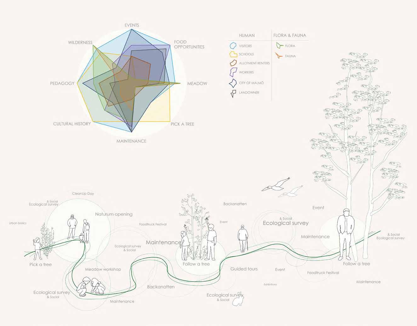
WHO: Target audience: Flora, fauna & humans.
Flora & Fauna: Flowers, trees, grass... Birds, insects, rabbits...
Humans: Visitors Schools
Allotment renters
Workers
City of Malmö
Land owner
HOW: When transforming Lokstallarna into a naturum, we need to ask ourselves the right questions; To what extent should the natural vegetation dynamics be influenced? And how to open the site to the public without endangering the fauna and flora present on site? How can we create a naturum with these constraints?
As a first step, we decided to start making the place more comfortable; using workshops and people’s good will, we want to clean the place of its visual garbage. Add toilets in the main building to make it easier to stay longer in the area. And of course make the place accessible with entrances and paths. There is however a hierarchy for the entrances. Some are accessible and easy to find, while others are hidden and could only be found by adventurous people. Once what we call “the basics” will be done, we plan on announcing the opening of Naturum Lokstallarna to the public through different media such as newspapers, posters and facebook.
The site has been divided into different patches depending on successional stage and atmosphere. The patches are based on the book Landscape ecology by Richard TT Forman, and then simplified to fit into this project. Ecological surveys will therefore take place to make an inventory of biodiversity, of the evolution of succession and single plants. They will be made by researchers, landscapers, ecologists and other relevant people. We will then use these ecological surveys as a base for deciding what to do with each patch. How will it be maintained for the next year and further? Freeze, develop or let patches be as they are? The idea is to have different stages of succession at site to inform people.
Creating softer slopes to be able to walk up on higher altitude. To create them, we want to use soil, dirt and demolished buildings from the site. Use these slopes as learning opportunities/experiments, by inviting people to follow the process of re-vegetation. What will grow here? How fast? Designing to make it possible for nature to design. Is it possible to design for wilderness? Using this same method, we want to delimitate the paths around the site with similar experiments. Protecting chosen patches from stepping by doing so and increasing biodiversity by bringing new materials.
Creating paths and showing people where to walk instead of where they shouldn’t. The idea is to make a different path for each stage of evolution of patches. Play between the heights to emphasize the different atmospheres and to protect nature by avoiding stepping. E.g: Monkey bridges - making it possible to see the later stages of succession from another perspective, without harming the flora. These paths will be re-defined according to the site’s evolution through ecological and social surveys.
Creating interaction between people and the place. Along the paths described above, we want to put up some frames around key views, places or plants. Using the frames to make people aware of where to look, smell, touch and go. The frames are meant to move around the site, depending on the season or the people’s changing interests. They can also be used to encourage people to touch something, like Stachys byzantina. To put up these furnitures, we want to organise a workshop where people create the frames with materials found on site and later choose where to place them.
Naturum = visitor center in nature
According to Naturvårdsverket (Swedish Environmental Protection Agency) a nature visitor center is connected to a national park or nature reserve (differs from our site). Naturum offers guided tours, theme nights, literature and multimedia.
Wildscape = “complexes of spontaneous “ruderal” vegetation that colonize urban disturbed sites [...] A continuum ranging from wilderness to apparently ordered spaces, with different levels of wildness existing at multiple different scales at each locality”. - Anna Jorgensen
The new wilderness = nature taking place in post-industrial sites that is made accessible to the public.
As a visitor you can be inside and outdoors depending on season and weather, since we are making the building a part of our naturum. More than this, events and workshops will take place throughout the seasons. For example, being a part of Backanatten that is happening every November. Repeated workshops like the temporary meadows with the purpose of increasing biodiversity and activating people on site. Another way to activate people and emotionally attach them to the place is to let children choose a tree. The children can follow the tree growing throughout the years.
OUTCOME: Lokstallarna will act as a complement to the other nature and culture centers in Skåne. The other nature centers are placed in protected areas, where the focus often lies in sea life or wetlands. Our site would be a place close to the city where children, families, teenagers, researchers and animals can become involved with the new wilderness.
This project is different from existing parks in Malmö, because of how it embraces wilderness. It could nurture tourism in a city like Malmö and put Kirseberg on the map, which hopefully would work well with Malmö City. We are aware of the masterplan ideas and believe that this project could either be just over a few years in the meantime, or be developed into something more lasting, depending on peoples reactions towards it. If the masterplan proceeds as planned, some parts of our project might be the foundation for the proposed green spaces in the new neighbourhood.
Today, Lokstallarna is a green island in the central parts of Malmö. Let us keep it that way.
“People were coming to care for the natural world, as they were made aware of the natural world” - David Attenborough
REFERENCES
Attenborough, David. David Attenborough - A life on our planet. (2020). Forman T.T., Richard. Landscape Ecology. (1986).
Jorgensen, Anna & Keenan, Richard. Urban Wildscapes. (2011). Naturvardsverket.se. Naturum - visitor centres in nature. (2020). Sennett, Richard. Edges: Self and City.
The green arrow is showing how developed the vegetation is, the grey one is showing how active the industry is. The less active industry, the more developed and lush vegetation.

Travelling through sites where man has had an impact.The transect runs from the northern harbour in Malmö, through the middle harbour to Lokstallarna. The aim being to explore different kinds of boundaries created by humans, and how they could be seen as an opportunity from another perspective. Passing by many industries, it became clear that vegetation really easily overtakes a space when abandoned by humans. This tableau shows that Lokstallarna has had a longer time, compared to other similar spots discovered in the transect, to recover from the previous industries on site, thus the vegetation is much wilder and more diverse.


Lokstallarna n Transect line Qualities found on site Northen harbour Middle harbour Central Malmö Lokstallarna Spontaneous vegetation Free space Species specific for postindustrial sites Food opportunities Cultural heritage Location Different atmospheres/ ambiances Coquel
n 1960
Itinerary Northenharbour Middle harbour Central Malmö
Inès,
Losman Klara, Persson Anna LK0370 - Group 2
50 100 % 2020 Years
The documentary David Attenborough - A life on our planet enlights that the wildlife decreases fast, meanwhile the population increases. In 1960 there were 62% of wilderness remaining, while in 2020 there is only 35% left.
Mapping
This tableau shows the overall context of Lokstallarna. Referring to the work “Edges: Self and City” by Richard Sennet, Lokstallarna is defined as a diverse border/edge, between surrounding areas. Malmö is not missing parks, they are just all maintained in similar ways to fit into the urban and social realm. Lokstallarna, with its special character, could be an escape for city dwellers. With many schools in the area, and more to come according to the masterplan, this site could be a great spot for kids, teaching them about the new wilderness. Therefore, Lokstallarna could be an urban-cultural complement to the other naturum in Skåne.

naturum
Green
How
spaces accessible to the public
diverse the vegetation is from low to high EntranceSchool
n
Coquel Inès, Losman Klara, Persson Anna LK0370 - Group 2
Listening
Playing Feeling
Learning
Exploring
Viewing
Urban wildscapes are defined by Anna Jorgensen as: “complexes of spontaneous “ruderal” vegetation that colonize urban disturbed sites [...] A continuum ranging from wilderness to apparently ordered spaces, with different levels of wildness existing at multiple different scales at each locality”.
The new wilderness is nature taking place in post-industrial sites that is made accessible to the public.

Wild is (of an animal or plant) living or growing spontaneously in an environment; not domesticated or cultivated.
Ecology is the scientific study of the relationships between organisms and their environment. RT Foreman definition
Wildscapes - Flora Fauna Humans
Biodiversity is the variety of plant and animal life in the world or in a particular habitat.
The aim is to create a naturum (a nature visitor center) in Lokstallarna. This wildscape will be a place where the new wilderness is allowed, and even encouraged, to take place, with at the same time people taking part in the cultural history of this post-industrial site in central Malmö. At Lokstallarna nature has started to take its course and all stages of succession are represented. The idea is to transform Lokstallarna into a link between humans and wilderness, while making an eco-friendly area in the center of the city. Lokstallarna will act as a diverse link between the flora, the fauna and humans. By using material found on site, and with as little interference as possible we want to keep (and possibly increase) the biodiversity and wilderness of this place.
high
Coquel Inès, Losman Klara, Persson Anna LK0370 - Group 2
Intentions of maintenance
Freeze is used when the aim is to keep the patch in its current state. To remove vegetation. This could be done by using mechanical methods, burning or grazing.
Develop is a way to design with maintenance. You could take out invasive species, arrange the vegetation to fit a certain frame etc. This could also mean that by design let the patch grow into the next successional stage.
Let nature take its course is to do nothing. Watch it grow.
Patchwork
This tableau shows the plant species found in Lokstallarna on site visits and ecological surveys. With help from the book Landscape Ecology by Richard T.T Forman, Lokstallarna was divided into patches, depending on how far the selected area had come in succession, ranging from stage one to stage three.

In order to keep biodiversity high, the site must be maintained in certain ways, using a combination of controlled processes and natural dynamics. There are three types of maintenance: freeze, develop and let nature take its course.
Over time, the patches on this tableau might / will change, depending on reactions from the public and the researchers.
Stage 1 Succession Stage 2 Stage 3
Coquel Inès, Losman Klara, Persson Anna LK0370 Group 2
Inviting researchers, landscapers and other relevant people to do ecological surveys and having experiments on site. Why not have a SLU lab here as a complement to the landscape laboratories in Alnarp.


Design = framing views, entrances, historical objects and specific species to let people know what should be seen. We are inviting schools to help us make the frames and where to put them.
Design = leaving piles. Letting nature take its course. Piles of demolished buildings on site have been left behind a seethrough fence. With peep-holes the piles are being framed and visitors will know there is something worth watching here. Seeds from closeby will have the opportunity to land and grow here. The same material will be used to mark out the patches with higher vegetation. This will keep people from walking there and also show how vegetation starts to grow in the material.
By creating Lokstallarna into a naturum people can be informed about nature and at the same time be aware of the environmental issues and human actions. The visitors are welcome to participate. Instead of building a new neighbourhood area this would be a green public, eco friendly space close to the city center.

Main focus has this far been on Flora and Humans. Before opening up the naturum there should be ecological surveys made on the fauna. Rabbits, birds and insects are part of the fauna we have noticed on the site. What also should be investigated is the pollution on site.


Having temporary meadows on the hard surfaces is a way to invite people to the site and show what could grow here instead of cement and asphalt.

The pots that the meadows are planted in are movable and could be arranged in different ways in different spots at the site. This is a great way to include people to engage with the site and affect how it looks.
Design = accessibility for people to be able to walk and at the same time protecting the flora underneath. The paths are in different heights depending on the successional stage of the patch. Low vegetation equals a low path, while higher vegetation requires elevated paths like monkey bridges.
Pick a tree, follow a tree. Inviting schools in the area to have a workshop. Letting the children find a tree and watch it grow throughout the years. Continually follow up and let the children know how their trees have developed.
A way to experience the past in the present. Let people take part of this post-industrial site and enlighten the historical traces.


This tableau is used to argue over the different functions of an urban naturum like Lokstallarna. Bring to awareness what Lokstallarna have to offer to the public and use the site as a visitor center for learning about the urban wilderness. According to Naturvårdsverket, a naturum should offer “guided tours, theme nights, possibilities to make research and provide a pedagogical aspect” among other things. In this case, framing is an important part of the process of achieving these goals. Framing certain species, historical objects, stages of succession and views is a big part of making people understand and learn about nature on these post-industrial sites. Using as much material found on site as possible for the paths, the feeling of wilderness will hopefully not be too disturbed.
 Humulus lupus
Traces of rabbits
Link humans with nature. Using bigger frames that are possible to sit in. Have a pause and look at the beautiful surroundings. Can be seen from a distance and inviting people to come here.
lokstallarna
Functions of our naturum
Coquel Inès, Losman Klara, Persson Anna LK0370 - Group 2
Humulus lupus
Traces of rabbits
Link humans with nature. Using bigger frames that are possible to sit in. Have a pause and look at the beautiful surroundings. Can be seen from a distance and inviting people to come here.
lokstallarna
Functions of our naturum
Coquel Inès, Losman Klara, Persson Anna LK0370 - Group 2
The stakeholders are the living things with an interest or concern in the evolution of Lokstallarna. This diagram represents the different interests of each stakeholder present nowadays or in the future on site. Their interests are the base of the site’s evolution.
Time
The time frame of this project is flexible. It could last over five, ten years or even forever. Depending on how people react to it, maybe the masterplan ideas are changed or postponed?
But something that can not last forever is some ways of maintenance. It would work fine to freeze a patch up to about five years. After that nature would possibly be too strong and the patch would need to transit into the next stage of succession.
Stakeholders and timelineInvestigation of pollution
This tableau aims to show different stakeholders and what they value. The stakeholders are divided in two groups, one referring to flora and fauna, the other to humans. Their importance is considered as equal. Humans are further divided into sub groups. The score is partly based on interviews and anonymous questionnaires. They all have different interests, but all agree on the most important ones. Time is seen as an iterative sequence, where ecological surveys, maintenance and social events are happening repeatedly.
Stakeholders interests Coquel Inès, Losman Klara, Persson Anna LK0370 - Group 2Create accessibility
Using demolished buildings from site to bring down the slope
As a follow up from the survey, we decide if a place should be frozen, developed or if we should let nature take its course. In the sequence below, as a response to the ecological and social survey, a stage 2 evolves to a stage 3 over time.
Involving people
Knowledge construction
Create accessibility
Path construction evolving depending on the stage of the surrounding patches.
Insert framing to the site to bring attention to overall views or details. Helps us decide how to organize diffrent patches and if we should freeze it, develop it or let nature take its course.
Knowledge construction
Frames added, kept or taken down, depending on people reaction and feedback.
Ecological surveys
Use workshops to involve people, activate the place, and allows us to use hard surface areas like parking lots.
Succession and evolution of the site
Social surveys
Take acknowledge of peoples reactions on ecological surverys and re-think the space depending on both people and science.
Meadows
Example of one of the workshops. Meadows placed in pots that are movable keeps the place active.

Using site visits, mapping of vegetation and topography maps, one extended cut was created from different parts of the site. This is aiming to get an overview of the different evolutions possible for Lokstallarna depending on the area.
The tableau is highlighting different parts of the project, ranging from accessibility and knowledge construction to ecological surveys and people involvement. When looking at this tableau you will understand the iterative process of the project, some parts will work when others will not. If a patch evolves into a later stage of succession, the paths have to evolve accordingly. Meaning that the higher the vegetation is, the higher the path will be, in order to emphasize the different atmosphere in different patches and to protect the flora from stepping.
Freeze Develop Freeze
1 2 3 4 5 6
Maintenance Time
1 2 3 4 5 6 Map of the different cuts
Coquel Inès, Losman Klara, Persson Anna LK0370 - Group 2
The contemporary city doesn’t necessarily have to proceed along the same lines as those laid down by the classical city… Different things are happening today, new phenomena that call for new solutions and new spaces.The open space of the city has to respond to two relatively re-cent ideas: one is that of freedom – a greater degree of freedom than the one the streetorsquarecanprovide,-andtheother,thatofadiversificationintherangeofuses.”- Eduard Bru
Urban voids, or also known as lost space, has been discussed within landscape architecture, planning and urban design for centuries, but often goes unnoticed and underutilized. With city populations growing, there is increased pressure to provide outdoor spaces for inhabitants. Urban void space has been discussed within landscape architecture, planning and urban design for centuries, but often goes unnoticed and underutilized. By recognising the voids and taking them back from the oblivion and enabling the reflection by society of possible interventions.
The concept and tools that is provided in this plan-guide will function as a support for the life, identity and community building in Kirseberg, for people who colonize and “squatter” these urban voids, establishing the necessary geometric and material conditions in order to qualify them. The plan-guide is constructed to create a new attitude towards urban redevelopment by focusing and further developing the site with small-scale prototype interventions that aims to parasiting the area while supporting individual efforts and natural processes that are already established at Lokstallarna.
GROUP 3
 Ilse Köhne - Felipe Mujica - Tuula Kuusemaa
VOIDS
AS CONCEPT AND SITE ANALYZIS
This plan-guide focuses on the functional void/planning void of the post-industrial site Lokstallarna. Those voids has characteristics that connect it with the memory and natural condition associated with the phenomenological and geographical void, respectively. Unlike phenomenological and geographic voids, however, the expanding functional void present in today’s urban fabric is a relatively new occurrence for contemporary cities that formed since the advent of the Industrial Revolution. Even when focusing on functional voids within the post-industrial sites, there is still a broad range of urban void conditions and characteristics that exist. Empty and abandoned spaces come in many different shapes, sizes, and forms. Each void has its own unique character that is a reflection on the history, location, and surrounding context of the space.

The relationship between the absence of use, of activity, and the sense of freedom, of expectancy, is fundamental to understanding the evocative potential of the city’s terrains vagues. First we need to understand that the word “void” has both a positive and a negative connotation. As Catalan architect and professor’s , Ignasi de Sola-Morales Rubio explains: the french word “vague” (void in english) with latin roots is the result of the sum of two single words:

Vacuus: empty, vacant, unoccupied
Vagus: uncertain, undefined

It has a contradiction within its meaning, and understanding that this contradiction defines most of the voids identities is a positive factor to involve and incorporate them to the common usage of the city, understanding them as opportunity places instead of voids.
PLANNING VOID
This void is characterized by history and context. It is a void that are created due to the faulty planning process. These are the voids that are most visible in an urban area.
FUNCTIONAL VOID
The functional void occurs on a variety of different scales: local, regional, national, and global. This void type represents a change in the pattern of use within the urban environment. Local history and geography often play an important role in determining to what extent the void is revealed.
VOIDS CREATES A NET

Lokstallarna - A sum of voids
The fragmentation enables the consideration of a network of spaces tied to urban patterns and legacy. The layer of urban voids can form a flexible approach in areas of development where urban voids can function as connecting elements, which retains and builds a local pattern of open space.


Overgrown vegetation
Parkinglots
Private alotments
New buildings
Demolished buildings
A map of Lokstallarna between the year 1938-47. The map illustrates what the site is today in 2020, by marking the different interventions and how the voids has developed.
Lokstallarna - Net of voidsLokstallarna - The heart of the net
FUNCTIONALVOIDS PLANNINGVOIDS VEGETATION SERVICEBUILDINGS RESIDENTALBUILDINGS INFRASTRUCTURE
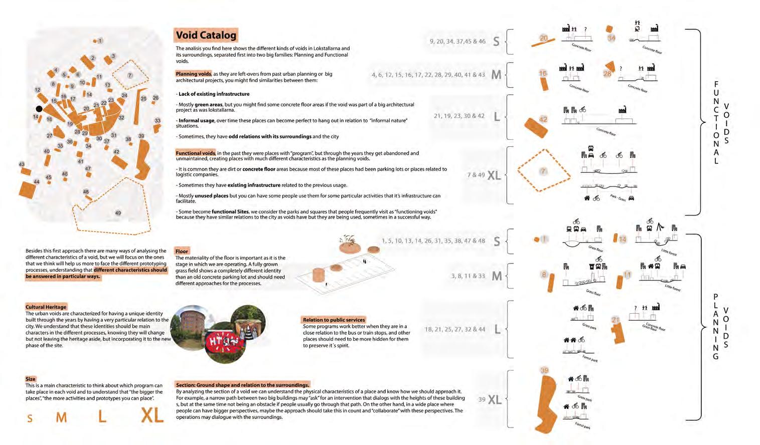
VOIDS TOOL CATALOG
PLAN-GUIDE PROCESS
PLACEMAKING, VOIDS, PROTOTYPES


BUILDING RELATIONSHIPS
WHAT IS PLACEMAKING?

Invite people to participate and be aware of the concept. Make sure to reach as many target groups as possible by using simple modules to draw attention to the site.
IDENTIFY VOIDS

Get to know the site and let people and di erent stakeholders be a part of the whole site.
TOOL: Plan-guide result
VOID
Use the catalouge that is provided as a tool to understand the qualities and oppurtunities from this particular perspective
PLACEMAKING WORKSHOP
A community participatory process that provides a forum for the people and stakeholders to work together. This includes workshops and community meetings to dicuss issues and ideas. These workshops can be held both at lokstallarna and other parts of the Kirseberg/Östervärn area.
BUILDING COMMUNITY
COMMUNITY EVENTS
When the community participation process is ongoing this plan-guide suggests to have di erent events as a strategy to make people continue to be at the site. We suggest that these events include the current clusters but also new ones. Use the placemaking workshop to discuss the events.
STAKEHOLDERS
PROTOTYPING
CREATIVE WORKSHOP
Use the above mentioned steps to get started with the creative workshop. To build a relationships within the community before this step important. This workshop is the step when stakeholders and people work toghether to create a design/modules that is needed for activites to happen at the site.
TOOL: Void catalouge and Module strategy
Lighter, quicker, cheaper
Lighter: Flexible and evolving according to needs

Quick: Fast to launch
Cheap: Fundamental shift from design led capital investment towards affordable programming and management solutions
APPROPRIATING THE VOIDS
PROTOTYPING
The prototypes at the site is a way to test the voids and also a way to activiate the site to provide public, hybrid and private spaces for the community of Kirseberg/Östervärn
NEW VISIONS/STRATEGIES?
The result of this plan-guide is depending on time and the outcomes of the di erent tools and events. The idea is that this plan-guide will provide a di erent way of creating spaces within these types of voids.
PLACEMAKING? IDENTIFY VOIDS = We want to know! VOID CATALOUGE TOOL CO M M U N I YT PLACEMAKING WORKSHOP PART I C I NOITAP P R O C SSE COMMUNITY EVENTS FOR WHO? WHAT? BY WHOM? COMMUNITY MEETINGS USING VOID CATALOUGE CREATE MODULES FOR A PARTICULAR VOID AND ACTIVITY LOCAL PEOPLEJERNHUSEN MALMÖ S DAT DNARG SUCRIC LETOH LARUTLUC / D ESIGN/FOOD EDGE IDENTIFY FOCUSGROUP TARGET GROUP WORKSHOP TARGET GROUP EVENTS STAKEHOLDERS LOCAL PEOPLE STRATEGY ANALYZE THE NEW VOIDS IDENTIFY ELEMENT FOR MAKING A GREAT PUBLIC SPACE STAKEHOLDERS LOCAL PEOPLE COMMUNITY MEETINGS DISCUSS THE VOID PROCESS NEW STRATEGY/VISION FOR HOW TO APPROACH THE VOIDS PARASITING SMALL INTERVENTIONS
WHAT IS
CATALOUGE
CREATIVE WORKSHOP
Y E A R 1 Y E A R 2 Y E A R 3 Y E A R 5 PROTOTYPE TIMELINE
FOR BY - CULTURAL EVENT - FOOD&BEVERAGE EVENT - DESIGN EVENT - SEASONAL EVENTS DECIDING THE VOID TO USE
Children, Elder people, Community groups, Local workers, Schools, Library, Church
PROTOTYPES PARA-SITING CONCEPT
SYSTEM CONCEPT
The diagram below illustrates how the concept of the modules is put into a system that can serve the different interests that both the current and new stakeholders at Kirseberg/Lokstallarna can apply to the modules, that are created according to the process-guide. The modules should respond to the specific location and emphasize the particular nature of the urban void. This prototype-approach can challenge conventional urban form, function, and thought by creating new urban places that recycle old and insert new materials, forms, and uses into the urban environment.

Theillustrationattherightisanexampleoftheconceptandthatthefuntction isprioritized,nottheform.Itshowshowtheopen,hybridandprivatemodule can be designed.
The hybrid and close modules are thought-out so the land owners can have an income for their land being used while we provide a tool to people in the community interested in developing their own business. This is the step by step to understand how this procedure works:
1- Understanding which activities are a good plan for every particular void we mapped so it brings benefit to the area and the community
2- Involving both landowners and people interested in developing a business together in the workshop stages of the plan guide, so we can develop a strategy that fits both their interests and at the same time respond to our analisis.
3- Developing the contract of how this three-part-society will function with the following structure: Para+site group Loans for 5 years the prototype to the Landowner, and then he rents it to the interested person in a price that will provide the owner an coherent Income.
4- In relation to the activity taking place in the selected void, we design and build together the hybrid or close module and finally the contract starts running when the module “opens its doors”
5- After 5 years the situation is re-evaluated in relation to how the society worked, what benefits it brought to the different stakeholders, the area and the community using it (in case it’s a hybrid module). Then it’s decided if the prototype is to be sold to the Landowner, if the contract should have another evaluation time or if it didn’t work.
Start-up process – Creative workshop
People being a part of the process Placemaking - inclusive and social People designing - function before form
The system is taking shape - private/public
Illustrations showing examples of the system and how the modules cooperate as one


1 2 3 4 5 6 7 1 2 3 4 5 6 7 8 9
The layer of urban voids can form a flexible approach in areas of development where urban voids can function as connecting elements, which retains and builds a local pattern of open space. Involving people in the dynamic process of incorporating the voids to the city helps them to appropriate these places and transform them into “sites” making them part of the community's identity. By following this plan-guide and the system that is provided, the prototypes will parasite and in that way, benefit both Malmö stad, the landowners, the stakeholders at the site and also the local people in the economic and social values which occurs when a prototype interacts with a particular type of site-specific void. The concept of parasiting aims to not only be applied at a particular site but at also at any net of urban-voids anywhere.

9 8
GROUP 4, HANNA ALFREDSSON, HANNA JOHANSSON, LELDE VITOLA

ENTERING THE INDUSTRIAL WILDSCAPE THE CROSSING
OF SOCIAL AND URBAN BOUNDARIES
A NEW WAY OF WALKING IN THE INDUSTRIAL LANDSCAPE
By transposing the pedestrian hiking into the urban and suburban we can change the world. By discovering industrial zones, highways, wastelands and fragments of the country sides on foot, these places acquire new functions, different from their previous use. Walking the trails offers new experiences of urbanity and opportunities of crossing social boundaries.
ADAPTING TO OUR CURRENT SITUATION
The dream about the untouched nature, without interference and sights of human presence is often seen in hiking culture. But the nature we live in is often far from untouched. In only one century and a half, the number of humans on earth has multiplied by ten, the countryside has become depopulated, half of the population is urban, and our landscape is greatly modified by human actions. Hiking in the untouched nature is no longer a part of our everyday life. Today we walk differently, and we walk elsewhere.
MAKE USE OF EXISTING STRUCTURES

Our project is built on the foundation of The Metropolitan Trails Network. The projects aim is to make walking routes that explore other territories and mobilizes a different culture than the traditional trails. By using the abandoned railroad that starts in Lokstallarna we can rediscover the historical path back to Dalby where the railroad used to go. We can make use of existing structures that have lost their previous functions and introduce an intriguing route for green mobility through the region.
USING THE MEANTIME
There has been a discussion about re-opening the railway with the project Simrishamnsbanan. The project has been postponed a number of times and its future is unclear. By using the railroad as a hiking trail could be a way for the region to save the railway for this possible future. Making use of the meantime and making the landscape accessible.
ENHANCING HISTORY
By connecting people and nature through this post-industrial trail we can enhance its history and work with local stakeholders and the public along the way. With the connection to the Metropolitan Trails organization Scania could have Sweden’s first Metropolitan Trail. This would not only be beneficial for the inhabitants and the municipalities involved but would also put the trail in an international context, attracting tourists and putting these places on the map. The trail’s dual identity makes it possible to cross cultures, audiences and create a breeding ground for creative placemaking.
LOKSTALLARNA AS AN ENTRANCE
What is now looked at as the outskirts of the city could become the entrance to Malmö. Lokstallarna could also work as a hub for travellers walking the trail. With social activities, food and accommodations it could either be the start, the stop or the ending of your journey down the trail.
The trail: The railway is still an important part of the landscape


LOKSTALLARNA THE ENTRANCE TO THE TRAIL
A BARRIER AND A FUTURE PROJECT FOR MALMÖ

Lokstallarna used to be railway workshops, owned and managed by the Swedish Railwaycompany. In Malmö city’s master plan the future for Lokstallarna is that it should be turned into a new residential area - including schools and small businesses - and thereby become a part of the popular Kirseberg district. Today it is a barrier itself, behind fences and infrastructure.
Shortcuts are created when necessary and for those who can find them
USED TO BE THE SECOND LARGEST WORKPLACE IN MALMÖ
The site used to be outside of Malmö’s borders and for a long time only used for farming, but in the early 1900s SJ (the state owned Swedish railway company) needed workshops and the site was deemed strategically located. In 1918 they invested what in today’s wage index would be 1,1 billion Swedish kronor. In the 1980s SJ began the settlement of the workplace, and in 1993 other companies were welcomed to the site.
 Lokstallarna:
 Existing structures at site
Lokstallarna:
Lokstallarna: Existing structures at site
POLLUTIONS BUT ALSO HISTORY AND GREENERY


Lokstallarna’s history is visible not only in the buildings and the railways stretching over the area, but also in the polluted soil and scars in the landscape that an industry can leave behind. In 2015 a pollution survey concluded that the site has areas where the pollution is classified as dangerous for humans and the environment. But there are also promises about greenery that could reduce the pollution at the site. The wild nature can attract people and create a unique relationship with Lokstallarna as a wild zone in the city.
ALREADY IN USE
SJ has a long history of building parks, some traces of it are still visible at Lokstallarna as nature is taking over. The allotments that were founded at the same time as the train workshops are still there with people growing crops and flowers. Lokstallarna and the abandoned railway are starting to be discovered by the residents in Malmö, with small trails being made in the wild greenery. New entrances are being made by its users, behind fences and shortcuts across closed areas, and the site’s qualities are starting to be appreciated for what they are - Lokstallarna is becoming an asset for the city.
Lokstallarna: Nature taking over
Lokstallarna: Industrial potential
CONNECTING THE REGION
MEETING OUR NEIGHBOURS
Places outside the city centres are seldom seen as attractive. City outskirts, a depopulated countryside and monoculture agriculture fields are often neglected in traditional planning. By making this trail we can offer representations of spaces that are no longer seen as beneficial, abandoned or forgotten. By doing that, we can encounter neighborhoods around us that we have previously turned our backs to and at the same time establish collective places in our city and promote space for pedestrians, from local to national scale.
CROSSING BORDERS
The Metropolitan Trails emerge where the peri-urban walking and the classic hiking meets. Its dual culture (intellectual and athletic, the general public and professionals, the unique and the popular) is the foundation that can challenge the social rigidness of our spaces. Cultural activation with social workshops as well as physical activities will create a living and exciting journey, making it possible not only to cross the municipal borders, but also the psychological ones.
DALBY MALMÖ BURLÖV MALMÖ LOKSTALLARNA
Regional Map: Crosses four municipalities
STAFFANSTORP
OLD STRUCTURESNEW NARRATIVES
THE SOUL OF THE RAILWAY
The railway was a force in defining industrial Sweden and bringing it into the modern age. The railroad used to bring goods and travelers to new places, with stops along the way for more people to get on or off. In turning the railway into a trail we honor its history, where people can continue the tradition but by foot.
EXPLORE CONTEMPORARY URBANITY
The abandoned railroads that run from city centers, through urban, peri-urban and rural spaces, create a continuous space, a coherent system. We can distinguish three different landscape types throughout the reach of the proposed trail. From urban, through agricultural into the rural. But are these concepts really what they used to be? With the internet people don’t have to go from the countryside into the city to work. We can see an increasing trend of being self-sufficient in the cities with urban farming. And who says an agricultural field of rapeseeds isn’t a beautiful nature experience? This is our new urban reality. Our most common habitat.
DALBY CHURCH
DALBY STATION
DALBY SÖDERSKOG NATIONAL PARK
KYRKHEDDINGE CHURCH
OLD SUGAR FACTORY STAFFANSTORP STATION
1:60 000 ´
DALBY QUARRY
Regional Map: Three zones divide the trail and offers insights in what is urban/rural
”NATURE”
”AGRICULTURAL”
”URBAN”
STAFFANSTORP
DALBY
PROJECT FOUNDATION
- REGIONAL FUNDINGS AND STAKEHOLDERS ACTIONS
INTERNATIONAL PRESTIGE
The trail would primarily be a regional project, with the start of Lokstallarna in Malmö. The region and the four municipalities involved would be the primary investors. The trail would be a way to bring excitement into the region and incite economic growth. The Scania region could, beside the organization and economic fundings, see this trail as a tool to create a shortcut in the popular Scania-trail that covers the region.
With the connection to the Metropolitan trail network this trail would gain branding and international prestige. They could also bring practical tools and design aspects for a future that can only be given from an experienced eye.
Rules and regulations
Tools
I

nternational National Regional Local
LOCAL ACTORS INVOLVED
At Lokstallarna the site’s owner Jernhusen is already pushing for a change in the plan program. For them this project could be a branding opportunity. To work with the site and trail could be a way to gain people’s interest as well as the interest of potential companies and housing actors.
Other companies and organizations close to the trail should also be a part of the transformation of the site. In the Kirseberg area there are a multitude of schools and sportscenter, to which the trail would be an opportunity for recreational use. Along the trail are several churches, and by using the trail as a pilgrimage path this would gain this community. Restaurants and hotels along the trail would be strong financial gainers along the trail. All these actors should be allowed to take part in the planning in the trail.
A PART OF THE EVERYDAY LIFE
Beside being a recreational addition in the everyday life of the citizens, this is an opportunity for them to be involved in their public space. The users should be able to make their contribution to the area, and have their say in where the placemaking and facilities should be located. Workshops and walks arranged by organizations connected to the trail/site and the region could be a way to start this.
Personal
Inspiration
Branding
Tourism Cooperation Regional strategies Projects
Funding
Tourism
Participation
Application
Physical placemaking Activities
Usage
Open calls
Voluntary participation
Recreation
Making Activities
Usage
METROPOLITAN TRAILS
Bordeaux, Milan, Marseille
Istanbul, London, Tunis, Avignon
Paris, Athens, Köln, Toulon
Boston
MUNICIPALITIES
ACTORS
ACTORS
THE PUBLIC
Malmö, Burlöv, Sta anstorp, Dalby STF Öresunds region
Skåneleden
Lokstallarna studios, Jernhusen
Allotments, City Archives, Växtverket
Sportcenters, Churches, Science labs
Museums, Farmers, Theaters, Resturants
Local actors in Malmö, Burlöv, Sta anstorp, Dalby
Youth, Elderly, Children, Working in Area,
Organisations, Schools, Universities
Cultural- and Sport associations Artists, Volunteers
STAKEHOLDER INVOLVMENT IN PROCESS
Preliminary Studies Temporary Design
Design Development Contract Administration
Construction Administration Management
 Municipalities
Jernhusen
Lokstallarna Studios
Metropolitan Trails
Local actors
The Public Building Company
Municipalities
Jernhusen
Lokstallarna Studios
Metropolitan Trails
Local actors
The Public Building Company
PROTOTYPE TEMPORAL PERMANENT CONTINOUS
WORKSHOPS COLLABORATIONS CONSTRUCTIONEVALUATION Little In uence Big In uence
Lokstallarna is strategically located but still cut off from the city
ANALYSIS LOKSTALLARNA
LACK OF GREEN AREAS

Malmö is today at the bottom ratings in Sweden of how much green areas are available to the public. According to SCB (Swedish Central Bureau of Statistics) Malmö has the highest number of residents per green area, and is the second most hard surfaced city per capita. The city needs more green areas as well as their connection to ensure green mobility not only in intended public spaces, but also in industrial parts of the city.
BARRIERS
Today there are large barriers that cut Lokstallarna off from the city. Big infrastructural elements like roads and railroads pose a threat for the development of the site. There are also barriers around the site itself. There is only one entrance to the site today, otherwise it is fenced in. There is a need for more entrances to activate the space.
MAKING CONNECTIONS
The connection to the city center also needs to improve for the trail to be able to be complete and for people to come to Lokstallarna. The first step is to create a connection to Värnhem that is easy to walk or bike.
Suggested bike/pedestrian road to make an connection to Värnhem - a hub for public transport
The trail: It offers a barrier-breaking way over infrastructure
´ 1:15 000 AREA OF CONFLICT BARRIER ROAD BARRIER RAILWAY TRAIN STATION NODE OF INTEREST LOKSTALLARNA WITH SUGGESTED TRAIL ´ 1:5 000 Järnvägsstation Väg Järnväg Idrottsplan/Anläggning omr Bebyggelse Industri Vatten Öppen Mark Torg LOKSTALLARNA AND SUGGESTED TRAIL NEW SUGGESTED BIKE/PEDESTRIAN ROAD VÄRNHEMSTTORGET
INTERNATIONAL REGIONAL CITY CENTER LOCAL PERSONAL
The Trail could act as a barrier-breaker and invite the Region and the World into Lokstallarna
The trail posts a great opportunity for green mobility. We can cross great infrastructure without having to encounter a single car. People have already found this hidden treasure, we just need to enhance it and make it accessible.

INNOVATION PROCESS
WHY STRATEGIES 1:ST STEP 2:ND STEP 3:RD STEP 4:TH STEP 5:TH STEP
ENHANCING EXISTING ENTRANCES
CREATING NEW ENTRANCES CREATING SHORTCUTS AND CONNECTIONS
CREATING NEW ENTRANCE OVER RAILWAY

- Access to green areas
- Green mobility
- Regional connections
- User friendly
- Connecting greenspaces in a contious structure
ACCESSIBILITY
SEATING SAFE PASSAGES
LIGHTING MAIN ROADS
SIGNS
RESTING PLACES
FACILITIES (TOILETS, WATER)
GROUND MATERIAL


LIGHTING TRAIL
- Good for physical and mental health
- Daily activation
- Need for a space with all year round use
- Alternative to Skåneleden
- Safe comuting
GREEN MOBILITY
INFORMATION ABOUT TRAIL
CONNECTIONS WITH SCHOOLS
HIKING ROAD TO STAFFANSTORP
HIKING ROAD TO DALBY
RUNNING TRACK WALKING ROUTE SKIING TRAIL BIKE LANE
ENGAGING STAKEHOLDERS AND USERS, MAKING COLLABORATIONS
BUISSNESS SHEDS
- Drawing interest to site
- Use the knowledge at site
- Encourage local stakeholders
- Social hub
- Use structures and nodes at site
- Educational and artistic values
CULTURAL ACTIVATION
FOOD COURT
STAGE
PLACE MAKING
FIND NEW USES FOR ABANDONED STRUCTURES
- Discovering the new urban/rural
- Contribute to faschination for history and existing structures
- Malmös lack of green areas
- The potential of unprogrammed spaces
- Accessing the wild nature
PART OF NATURE
AGRICULTURE
WORKSHOPS ACTIVITY CENTER
ACCESSING THE TRAIL
EDUCATIONAL ECOLOGY
LIGHT EXHIBITION
ART EXHIBITION GUIDED TOURS
FRAMING NATURE
PHYTOREMIDIATION AND ENHANCING THE WILD NATURE
ANNUAL EVALUTAION ANNUAL EVALUTAION ANNUAL EVALUTAION ANNUAL EVALUTAION ANNUAL EVALUTAION
LOKSTALLARNA INTERVENTIONS IN 4 STEPS

Fourth step: Lightning along the tracks and bike roads creates a site more alive all year round. The focus should now be on the trail, which should reach its conclusion at Dalby.
Third step: Real benches and public space along with old carriages used as hubs, able to rent for small businesses/ organizations are added to the railway. The stage is added for cultural activities. The trail is continuing out of Burlöv towards Staffanstorp.
Second step: Another bike road created as a shortcut from Värnhem/Östervärn to Lokstallarna and towards Kirseberg. Thus making this an easier located place. Outside of the marked space the plan program continues as suggested by Malmö municipality.
First step: Opening up the site by making a shortcut through the site for bikes and pedestrians. Another shortcut along the railroad from Södra Bulltoftavägen. In the greenspace phytoremediation plants to enhance the greenery. In the railway yard: phytoremediation and seating. A food court inside of the center building. The trail’s first part is founded with it’s entrance from the greenspace.
Today: Today Lokstallarna is behind borders, used by the companies renting the area or pedestrian walking through the industrial gates - when they are open during daytime - or taking alternative ways - shortcuts through fences.
URBAN TRAILS THROUGH HISTORY PROJECT STRATEGIES


ACCESSIBILITY


By making Lokstallarna and the trail accessible we can connect people. At first it can be by putting up signs and creating entrances, making people aware of the site. When people start to use the trail more frequently the ground material can be changed for improved accessibility.
GREEN MOBILITY
We know today how important recreational activities are for our mental and physical health. The railroad is a tool for moving: a defined walk, along an interesting landscape. There is a foundation here that could easily be used for recreational means and help build a new green environment which could be part of a bigger structure not only in one city, but in the whole region.
CULTURAL ACTIVATION
To make people involved and invested in the site is a key for it to function. By creating workshops both on site and along the trail we engage both local stakeholders and residents. Building prototypes of resting places or creating a running race.
PART OF NATURE
There is a lack of green areas in all of the four municipalities. By making the trail available we can connect people with nature. By working with phytoremediation and ecological education we can create an interest both in the force of nature but also in the post industrial wildcape.
EVALUATION
The site should evolve organically by keeping the interventions that are appreciated and disregarding those who don’t work. Every year there should be a team responsible for Lokstallarna and the trail that are in contact with the stakeholders, evaluate the work that has been done and suggest new interventions for next year.
SALIX SP. - WILLOW
CERASTIUM ARVENSE - FIELD CHICKWEED
We suggest that by using time as a tool, with the help of phytoremediation - cleaning the polluted soil with plants - the area can start the cleansing process without scarring the area and destroying its identity.
POPULUS DELTOIDES X P. NIGRAHYBRID POPLAR

One survey for pollution in the ground at Lokstallarna was made by Ramböll in november 2015, by sampling in 26 test points in our area. The test was made for the safe requirements necessary for building office buildings/industrial areas/roads, NOT for housing or schools - all according to the Swedish Environmental Protection Agency's guidelines from 2009. Some areas showed high levels of lead and zink, as well as oil hydrocarbons. These are more apparently more delimited in plane but not in depth. Highest levels of metal pollution and oil hydrocarbons can be found around the eastern parts of the site. The survey’s conclusion is that the site has areas where the pollution is classified as dangerous for humans and the environment
DIGITALIS PURPUREA - COMMON FOXGLOVE
We suggest that by using time as a tool, with the help of phytoremediation cleaning the polluted soil with plants the area can start the cleansing process without scarring the area and destroying its identity. This process has already been initiated by nature itself, since those parts where the pollution is the most pressing concern today are green areas. For Jernhusen, the owner, this can for them be a prestige project showing how they by using an experimental and more environmentally friendly way work with a problem that they have at most of their 586 000 square meter locations.
LARREA TRIDENTATA - CREOSOTE BUSH
Lokstallarna: Phytoremediation planting area“The city has stretched beyond itself, in spaces described as suburbs, periphery, zones, neighborhoods, cities, peri-urban. Our representations have not evolved as quickly as our cities.
We live in spaces we don’t know no longer define or inhabit. The gap is growing between spatial reality and our representations of the city. All that is between the city and the countryside is generally judged in a negative way. “
(Metropolitan Trails, 2017)
The trail: Will offer urban and rural views
BURLÖV - BRICK
Both along the trail and the site, materiality should be used as a designing tool in placemaking and orientation. By making a material symbolize each involved municipality, they can be grounded at the Lokstallarna site as well as tell a story about each municipality. This will be used in both ground materiality and furnituring along the trail.
BURLÖV
Here symbolised in bricks, which symbolises this small town's industrial heritage and its historical brick architecture from the early 20th century.
Malmö:
STAFFANSTORP - WOOD CHIPS


Malmö is famously the Town of Willows, but here it’s seen as wood as a material.
Staffanstorp: Wood chips. Staffanstorp with it’s agriculture history visible in this organic material.

Dalby:
This area has been and is still a center for the quarry industry. Stones and gravel will represent this.

Railway:


Iron details, as seen in the rails, will symbolize the railway and the trail connecting everything.
The trail: Making the trail more accessible and prototyping furniture
MAKING A PUBLIC SPACE

The interventions to the Lokstallarna site are located along the parts we deemed more green or more culturally valued. They aim towards bringing a new greenspace and public space, to make Lokstallarna an open place with an entrance to the trail that brings you further but still keeping its foundation. The interventions are small, but noticeable. They are created to work with the site offering in the now - thus working with small means towards something more. Something small like adding lightning or another bike road across the area brings more life to the site - and allows it to be included in Malmö.
PROTOTYPING THE TRAIL
The start of the trail in Lokstallarna is today easy to find and follow, since most of the rail and markings from the railway are still visible and possible to follow to Staffanstorp. Due to the length and stakeholders involved, we suggest that it is built in different stages. The necessary facilities along the way could be viewed as prototypes, made to last one year/season and then moved if it is deemed they would be in better use at another location along the trail. Or if there are too few, or too many, it could easily be transferred along the trail.
The trail: A nighttime vision
 MALMÖ - WOOD
DALBY - STONE
RAILWAY - IRON
MALMÖ - WOOD
DALBY - STONE
RAILWAY - IRON
MALMÖ STAFFANSTORP TOWNS CONSTRUCTION PROTOTYPES (Benches, Place making) FACILITIES PROTOTYPES (Bathrooms, Water) DALBY
Lokstallarna: Entrance into the site beneath the infrastructure Lokstallarna: Possible future
ACTIVE THORUGHOUT THE YEAR
Spring
- Light exhibition
All year around
- Nature experiences
- Urban experiences
- Food truck market
- Running organizations


- Workshops
- Startup agriculture
Winter
- Winter on the trail (skiing, ice skating)
- Vegetation in winter
- Warm cabins
SPRING WINTER AUTUMN
SUMMER
Spring, Summer
- Rapeseed walks
Summer
- Music festival
- Food festival
- WIldscape walks
Spring, Summer, Autumn

- Guided tours
- Historical walks
- Food walk
- Meditative walks
Autumn & Winter
- Light exhibition
Autumn
- Harvest festival
- Exhibition of art (working with local artist)
- Horror walk (serial killers, Dalby killings, train robbery, execution places, mental hospitals, prisons, burning and witches)