SEPTEMBER 2023 SURVEYING AND MAPPING, ELEVATED An inside look at the technology of your GNSS rover and how it makes the magic happen Inner Workings GNSS SURVEYING UAVs MAPPING 21 NGS’ Online Position User Service INSIDE Legal Boundaries 30 Saving Our Infrastructure with UAVs 12

Looking Forward
By Jeff Thoreson
10 UAVs and Infrastructure


A number of bridge failures in recent years has brought about innovative ways civil engineers inspect and assess our infrastructure. With artificial intelligence now helping in so many areas, can it help prevent bridge collapses in the future?
September 2023 Volume 10 Number 8
Publisher Shawn Dewees shawn.dewees@xyht.com
Editor-in-Chief Jeff Thoreson jeff.thoreson@xyht.com

Director of Sales and Business Development Chuck Boteler chuck.boteler@xyht.com
Creative Director Ian Sager ian.sager@xyht.com
Accounting and Classifieds Angie Duman angie.duman@xyht.com
Circulation subscriptions@xyht.com Phone: 301-662-8171
Editor, Located Jeff Salmon jeff.salmon@xyht.com
Editor, Field Notes Eric Gladhill eric.gladhill@xyht.com
UAVs and AI: How Far Can They Go?

The need to fly uncrewed aerial vehicles farther and farther, and out of sight of the operator, presents a windfall of problems. Can artificial intelligence solve them?

NGS Revamps OPUS Projects

NOAA’s National Geodetic Survey (NGS) continues to improve its suite of Online Position User Service (OPUS) tools. How much will the latest version help surveyors?
What’s Inside Your Rover?
The GNSS rover has evolved into an essential part of a surveyor’s toolkit, although some mystery remains as to what that magic box does and how it does it. This three-part series will demystify the rover’s inner workings.
Legal Boundaries
Jeff Lucas takes a look at the importance of surveyors testifying in court as experts.
Contributing Writers Marc Delgado Philippe Hensel Jeff Lucas Juan Plaza Gavin Schrock
Copyright © 2023 xyHt magazine. Printed in U.S.A. No material may be reproduced in whole or in part without written permission from the publisher. The publisher assumes no responsibility for unsolicited material, the accuracy of information supplied by manufacturers, or opinions expressed by contributors.
Partners and Affiliates

xyHt 3 SEPTEMBER 2023 xyHt [ISSN 2373-7018 (print), ISSN 2373-7735 (online), CPC CPM No. 41437548] is free upon request to qualified subscribers in the United States. The Canadian subscription rate is US $20/year. The International subscription rate is US $40/ year. Periodicals postage paid at Frederick, MD and additional post offices. xyHt is published 12 months a year by xyHt LLC, 6 N. East Street, Frederick, MD 21701. POSTMASTER: Send changes of address to: xyHt Subscriptions, 6 N. East Street, Frederick, MD 21701. Send Canadian changes of address to: Box 697 STN A, Windsor, ON N9A 6N4, Canada. For advertising, editorial, or other information, write to xyHt LLC, Inc. or call 301-662-8171. CONTENTS SEPTEMBER 2023 FEATURES 12 21 30
5
7
LOCATED
SEPTEMBER 2023 SURVEYING AND MAPPING, ELEVATED An inside look at the technology of your GNSS rover and how it makes the magic happen Inner Workings GNSS SURVEYING UAV MAPPING 21 NGS’ Online Position User Service INSIDE LegalBoundaries 30 SavingOurInfrastructurewithUAVs 10 ON THE COVER: The insides of a GNSS rover; just exactly what’s in there and how does it actually work?
17 26 THE FAA’S REMOTE ID PROGRAM HAPPENINGS AT ESRI USER CONFERENCE A DIGITAL TWIN OF EARTH’S CLIMATE NEW PRODUCTS / NEW SOLUTIONS
THE IMAGING & GEOSPATIAL INFORMATION SOCIETY

Looking Forward
Is It Really Impossible?
AS THE SAYING GOES, IT’S ONLY IMPOSSIBLE UNTIL IT’S NOT. In the past when I’ve heard, or used, this bon mot I would think of the moon landing in 1969. I think of all the early astronomers who gazed at and intensely studied heavenly bodies, using them for navigation and location while knowing there was no hope of ever doing more than seeing them from the ground.
Now I often think of the geospatial professions when I hear this witticism. Early surveyors lugged physical equipment through rough and dangerous territory, never imagining that someday that load would be lightened by satellites orbiting in space, or small flying machines defying Newton’s laws of gravity, sending invisible digital signals that communicate with microchips and technology that even most of us who use that technology don’t understand.
To that point, xyHt writer Gavin Schrock thought it would be a good idea to open up one of the most important pieces of technology in the surveyor’s kit and take a deep look at what is physically inside and what makes the technology work. You’ve certainly seen many GNSS rovers, but our cover is an image taken from an angle you probably haven’t seen.
We’ll bring you his story in three parts (starting on page 26 and continuing in October and November) because it’s a fascinating in-depth look at the inner workings of the equipment.
In advance of the popular Commercial UAV Expo taking place this month in Las Vegas, we also want to bring you a couple of stories about those little flying machines I mentioned above. Writers Marc Delgado and Juan Plaza take separate looks at the way UAVs are changing the geospatial professions.
I hope you enjoy reading this issue.
 —Jeff Thoreson
xyHt 5 SEPTEMBER 2023

Located Located Located
Mapping Your World | UAV/UAS | Space | New Products
Are You Ready for the FAA Remote Identification Program?
BILLED AS A “LICENSE PLATE IN THE SKY,” the FAA’s Remote Identification (RID) program offers the capability of a drone in flight to provide identification and location information that can be received by other parties through a broadcast signal. The program goes into effect on the 16th of this month.

Who must comply? All drone pilots who are required to register their UAV(s) must operate in accordance with the rule on Remote ID. All UAVs that weigh more than 250 grams are required to register. Furthermore, even if you are using a sub-250-gram drone for Part 107 (commercial work) missions, you are still required to comply with the FAA’s RID program.
Is my UAV RID ready? Your UAV distributor or value-added retailer should have provided this information when you bought the unit. Still not sure? The FAA maintains a complete online database of all UAVs that have been certified as RID compliant. Go to www.faa.gov/listDocs to determine certification.
My legacy UAV doesn’t have RID built-in, what can I do? Fortunately, the FAA offers a retrofit option by using a Remote ID broadcast add-on module. Just a few examples are Dronetag’s Donetag Mini and Beacon and uAvionix’s pingRID.
These are FAA-approved broadcast modules that can be retrofitted to existing non-RID UAVs to comply with FAA’s RID program. At the time of writing, units range from $200 for the Dronetag Beacon, to $300 for the Dronetag Mini and PingRID, a fraction of the cost of purchasing a new standard RID drone.
These units are small and lightweight. The Dronetag Mini is 54x35x15 mm and weighs 32 grams. The Dronetag Beacon is even smaller at 37×26×16 mm and weighs only 16 grams. The pingRID is 25.40x16.63x43.42 mm and weighs 21 grams.
If I retrofit my UAV with a RID Broadcast module, can I share it between UAVs in my fleet? This depends on your usage. If you are a Part 107 operator, you must have a separate RID Broadcast module for every UAV that you fly. Hobbyists (non-Part 107) are allowed to share one module between all drones owned by an individual.
Thanks to the vast number of pre-RID legacy UAVs, it’s reasonable to expect more modules to arrive on the market soon. A word of warning: before you buy, make sure your unit is certified by the FAA. Use the FAA link listed above to determine certification of the unit before purchasing.
Trimble Terra Office Workflow Delivers Integration with Esri ArcGIS Pro
TRIMBLE ANNOUNCED THE RELEASE OF THE TRIMBLE TERRA OFFICE ADD-IN for Esri ArcGIS Pro.
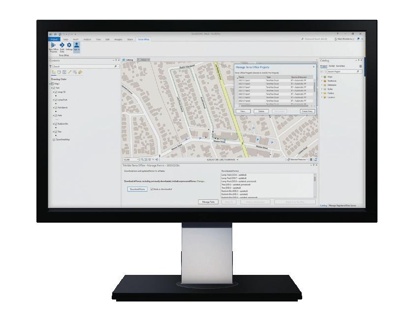
The add-in is a new product in Trimble’s Terra Office suite of desktop solutions for integrating Trimble TerraFlex field data collection software with GIS systems of record.
With a streamlined user interface, the new Terra Office add-in for ArcGIS Pro allows customers to connect TerraFlex workflows directly to their ArcGIS environment from within ArcGIS Pro, Esri’s desktop GIS application. An ArcGIS Pro user can now create and manage TerraFlex geospatial data collection projects without leaving the ArcGIS environment. The add-in enables connectivity to feature services (and hosted feature layers) published in ArcGIS Online and ArcGIS Enterprise, as well as traditional onpremises enterprise or personal geodatabases.
xyHt 7 SEPTEMBER 2023
Send your Located items to located@xyht.com
Compiled by Jeff Salmon
Buzzwords at Esri UC 2023
THE 43RD EDITION OF THE ESRI USER CONFERENCE CONCLUDED SUCCESSFULLY in July with more than 18,000 GIS enthusiasts attending the talks and sessions in San Diego, California. As one of the world’s most important mapping events, the Esri conference typically focuses on a wide range of cutting-edge GIS topics. Yet this year’s sessions on artificial intelligence (AI), earth observation imagery, and digital twins created a lot more buzz. Mapmakers seem to be even more eager to grasp how this trio of innovative technologies will change the way maps will be created in the near future.
MicroSurvey, Bricsys Introduce Survey Workflow Solution
SURVEYTOOLS FOR BRICSCAD COMBINES the powerful surfacing and point cloud tools from BricsCAD with a complete suite of survey tools for land surveyors from MicroSurvey. As an all-in-one solution SurveyTools reduces workflow friction with surfacing and contour creation in the same environment that the end deliverable is drafted in.
Users can accelerate their productivity with industry-specific tools developed by surveyors, for surveyors, while also benefiting from BricsCAD’s AI‐driven drafting tools, including linework and block generation from point descriptions (or import linework created in the field), COGO, surveying focused dynamic labelling, and geodetic tools.
SurveyTools offers a complete audit trail for values derived from computations and field data while the tools intelligently use data to create accurate and precise CAD deliverables.
EVENTS
Commercial UAV Expo

September 5-7
Las Vegas, NV
InterGeo
October 10-12
Berlin, Germany
GIS-Pro (URISA)
October 16–19
Columbus, OH
Trimble Dimensions
November 6-8
Las Vegas, NV
Autodesk University

November 13-15
Las Vegas, NV
GeoWeek
February 11-13, 2024
Denver, CO
The conference was also a launchpad for several companies, such as Bad Elf, Maxar, and Trimble to showcase their latest mapping products and services. Likewise, Esri released its most recent global land-use/land-cover map, which has been revamped using, what else, AI technology.
“We are constantly updating our land-cover map with new data and features, and this latest improvement ensures that anyone viewing temporal change can be confident what they are seeing represents the natural world,” said Sean Breyer, Esri program manager for ArcGIS Living Atlas of the World.
— Marc Delgado, marc.delgado@xyht.com

xyHt 8 SEPTEMBER 2023
DIGITAL TWINS SEEM TO BE EVERYWHERE THESE DAYS, from modern skyscrapers to entire smart cities. So how about creating a much bigger doppelgänger on a global scale?
Well, we are almost there. NVIDIA, the company that dominates the market for chips used in artificial intelligence (AI) systems, is building what it calls Earth-2, an interactive digital twin of the Earth’s climate. It will be used to speed up climate and weather predictions with interactive and high-resolution simulations powered by NVIDIA’s chips that are specifically created for large-scale AI applications and visualization of petabytes of climate data.
Similarly, the world’s oceans will also have their own digital alter ego. Six European countries have committed to collaborate in creating
Seeing Double
what they call the European Digital Twin of the Ocean (EU DTO), a platform that brings together various marine data and models to create a virtual replica of the oceans.


But first they must make the data interoperable as they come from various organizations, a difficult yet doable task. “It is a challenge, but it is a good challenge,” said Dr. Marina Tonani, a project manager at Mercator Ocean International, which collaborates with the DTO. “It is amazing what we are trying to do with the digital twin in general. This comprehensive information on the marine environment will have a big impact.”
— Marc Delgado, marc.delgado@xyht.com
xyHt 9 SEPTEMBER 2023

The Next A-Team
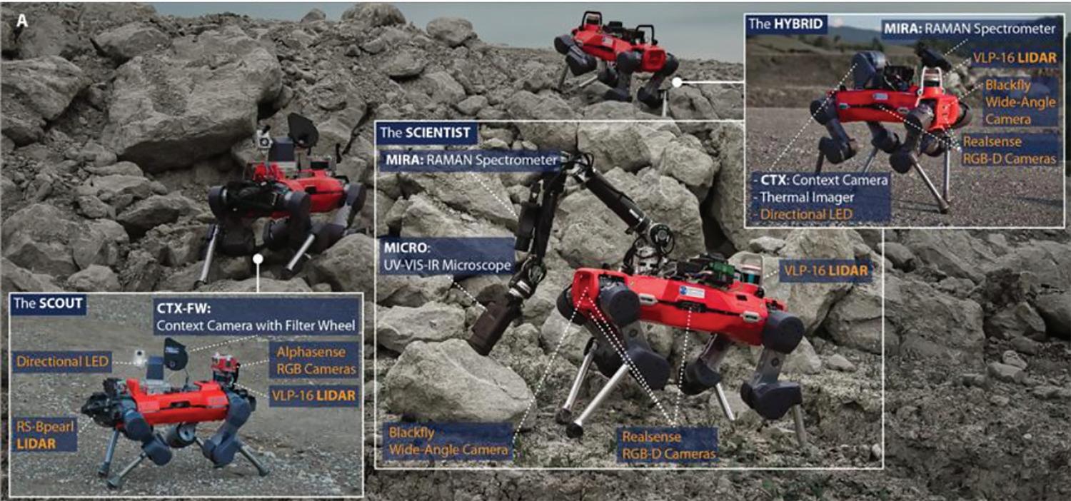
GEOSPATIAL DATA COLLECTORS MAY SOON HAVE A NEW ASSISTANT to help them capture information in the field, especially in places that are unsafe or harder to reach for humans. Welcome ANYmal, a quadruped robot that can autonomously operate in challenging environments. Especially designed by scientists from the ETH Zürich Robotic Systems for lunar exploration, ANYmal is equipped with laser sensors and cameras to allow it to discern its immediate surroundings while simultaneously creating maps to navigate itself. This year, its developers have also successfully tested how a team of three ANYmal robots can collaborate with each other in a real-world setting. During a study conducted in a quarry in Switzerland, each robot was given a unique task (one to explore the terrain, one to collect imagery, and another to analyze the images in-situ). Results of the study are promising as the robotic trio was able to carry out the mission in a shorter time compared to what a single robot could have done. “Robotic teams are effective in doing planetary exploration missions because tasks can be parallelized and the robots can be specialized for certain tasks while still being redundant," said Hendrik Kolvenbach, one of the authors of the study published in the Science Robotics journal. "The robotic team is more effective than the sum of its individuals."
 — Marc Delgado, marc.delgado@xyht.com
Carlson's BRx7 GNSS Solution

THE BRX7 GNSS RECEIVER WITH SURVCE/SURVPC delivers a modern and flexible GNSS RTK product for precision surveys, with an intuitive and familiar application software. The lightweight BRx7 receiver may be used as a rover, or as a base to send corrections to RTK UAVs or GNSS Rovers.
The unit provides a class-leading 800-plus channels, eight gigabytes of memory, tilt compensating ability, and a rugged, compact, IP67-rated housing. RTK performance is provided by the Athena GNSS engine, supporting multi-frequency GPS, GLONASS, BeiDou, Galileo, QZSS, IRNSS, and Atlas L-band capability. The BRx7 has an integrated dualband UHF transceiver and a quad-band GSM modem together with Wi-Fi and Bluetooth.
Jubilee Year for Copernicus
THE COPERNICUS SPACE PROGRAM, DUBBED AS EUROPE’S EYES ON EARTH, marks 25 years of successfully providing global observation and navigation services. With its fleet of satellites, including the seven Sentinel satellites, which are now indispensable in capturing remotely sensed imagery, and the 26 that comprise the Galileo constellation of advanced satellite navigation system, there’s surely a big chance that you have been benefitting from the Copernicus Space Program without knowing it.
From helping people get by with the everchanging weather, to improving everyone’s lives with better positioning, navigation, and timing data, Copernicus has been doing its job for more than two decades now. And all for free. Every bit of data and information produced by the Copernicus program is made available to the public free, thereby allowing other related services and businesses to develop. The European space industry is the second largest in the world after the U.S. with an estimated value of €62 billion and employing more than 200,000 workers.
Happy birthday, Copernicus!
— Marc Delgado, marc.delgado@xyht.com
TCarta to Deliver Satellite Derived Bathymetry for 13 Regions
TCARTA MARINE, A GLOBAL PROVIDER OF HYDROSPATIAL PRODUCTS AND SERVICES, has been awarded a contract to deliver satellite derived bathymetry (SDB) and seafloor classification data for the coastal zones of 13 regions around the world to the National Geospatial-Intelligence Agency (NGA) under contract to Maxar Technologies.
TCarta will deliver seabed depth and feature maps from high-resolution multispectral Maxar WorldView-2 and WorldView-3 satellite imagery for the 13 regions. SDB measurements are accurate to depths up to 30 meters depending on water conditions, with two-meter spatial resolution. Feature classification includes coral reefs, large rocks, sandbars, and other navigation hazards.
Stonex’s New X300 Laser Scanner
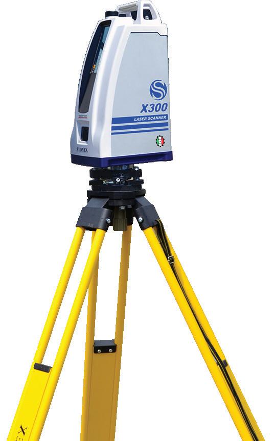
THE EASE OF USE, RELIABILITY, FLEXIBILITY, AND PRICE-POINT make X300 a highly competitive product. Now the unit has been improved with new features. The fully sealed case protects your inversion, making it possible to get the job done where others fail, regardless of dust, humidity, heat, or bumps. Push one button and control X300 with your smartphone or tablet. The unit features an HQ camera with a Sony
16-megapixel sensor, low distortion lens with HDR providing brilliant coloration, and wide tonal range. The X300 File Manager tool allows you to convert the data collected with the X300 Laser Scanner into Stonex Reconstructor file format or other standard formats. The files obtained can be used directly in third party software, such as CAD, forensic analysis, or road accident analysis.
xyHt 11 SEPTEMBER 2023
The Next BIG THING
By Marc M. Delgado, PhD
The period spanning 1992 to 2014 could just be the worst periods for America’s bridges. According to the database of the National Bridge Inventory (NBI), a total of 428 bridges collapsed in the U.S. during those two decades, and the majority of them were caused by structural defects.
For a country that prides itself on its long tradition of building monumental bridges, it is remarkable that more than 40,000 bridges in the U.S. are considered structurally deficient, including the famous Brooklyn Bridge of New York City. In addition, at least one in three bridges in the U.S. needs replacing or repairing, according to data from the Federal Highway Administration (FHWA), the agency that oversees the construction and maintenance of the nation’s highways and byways.
Protecting the safety of the public requires mandatory bridge inspections on a regular basis, normally at least once a year or every

xyHt 12 SEPTEMBER 2023
A string of high-profile bridge failures in recent years has underscored the importance of innovating the way we inspect and assess the condition of our vital civil infrastructure. Can the use of AI help prevent bridge collapses in the future? This award-winning engineer thinks so.
A quadcopter performs a bridge inspection by taking high-resolution digital images and scans.
two years. This interval depends on various factors, such as the bridge’s actual condition, the volume of traffic that crosses it, as well as its structural system, location, and age. Important data are collected during these periodic inspections to guide preventive and conservative maintenance work and help keep bridges safe and reliable throughout their service life.
Unfortunately, the techniques to assess the structural soundness of bridges are still mostly traditional, involving trained inspectors performing visual checkups. As such, these manual and subjective inspections are often laborious, time-consuming, expensive, and, as in the case of bridges that span wide bodies of water or deep valleys, dangerous.

Dr. Ali Khaloo wants to change that. After a decade of work, including a job as a civil engineer inspecting and rehabilitating major infrastructure systems in some of the most active seismic zones in the world, and later obtaining a Ph.D. in structural engineering and a postdoc in artificial intelligence (AI) at Cornell University, Khaloo in 2019 co-founded Aren, a tech company based in New York City. Aren provides AI powered solutions that can be used to safely and automatically detect a variety of structural deficiencies,
such as pavement cracks and corrosion on bridges and other infrastructure assets. Khaloo’s patented AI technology has already won awards, including the coveted COINS Grand Challenge, a global competition that recognizes innovative ideas that aim to solve challenges facing the construction sector.
In this interview, which has been edited for brevity and clarity, Khaloo shares with us his international experience in asset inspections, including how AI and image-capturing drones are now making bridge assessments more reliable. He also tells us why jobs of human bridge inspectors will not disappear any time soon.

HOW IMPORTANT IS UTILITIES AND ASSETS INSPECTION FOR GOVERNMENTS AND PRIVATE OWNERS?
Inspection is the first line of battle when it comes to civil infrastructure asset management. This is a mandatory step to understand the condition of the assets. Depending on the type and condition of the asset, inspections are done at a certain frequency in order to track the possible changes in the assets and avoid their significant degradation.
WHAT IS YOUR IMPRESSION OF CIVIL ASSETS MANAGEMENT IN THE U.S.?
Current methods of infrastructure inspection, assessment, and management are precarious and outdated. Unfortunately, this is a global phenomenon. Currently, engineers walk, climb, and use snooper trucks to assess miles of infrastructure and use their naked eyes to identify damage and take notes of their findings on a piece of paper. Then they have to go through decades of old assessment reports to compare their findings and understand if the bridge is deteriorating or not. This poor and insufficient information feeds maintenance recommendations and as a result, trillions of dollars in infrastructure budgets are poorly spent and people are getting killed. This problem is hitting the pockets of asset owners, consulting engineering firms, and insurance companies.
HOW THEN CAN UTILITIES AND ASSETS INSPECTION BE IMPROVED IN THE U.S.?
While the current inspection process has a long track record, it isn’t perfect. It relies heavily on human judgment, so it is prone to human errors and variability. Over the years, several notable studies have shown that bridge ratings can vary widely from one inspector to another.
Inspector variances don’t necessarily lead to unsafe operating conditions, but it does make it challenging to use inspection data quantitatively as a part of an asset management program. It is difficult to quantify the aging process itself, given current standards. The inspection team inevitably changes over the life of a structure, adding a new source of variability and inconsistency to the inspection process.
xyHt 13 SEPTEMBER 2023
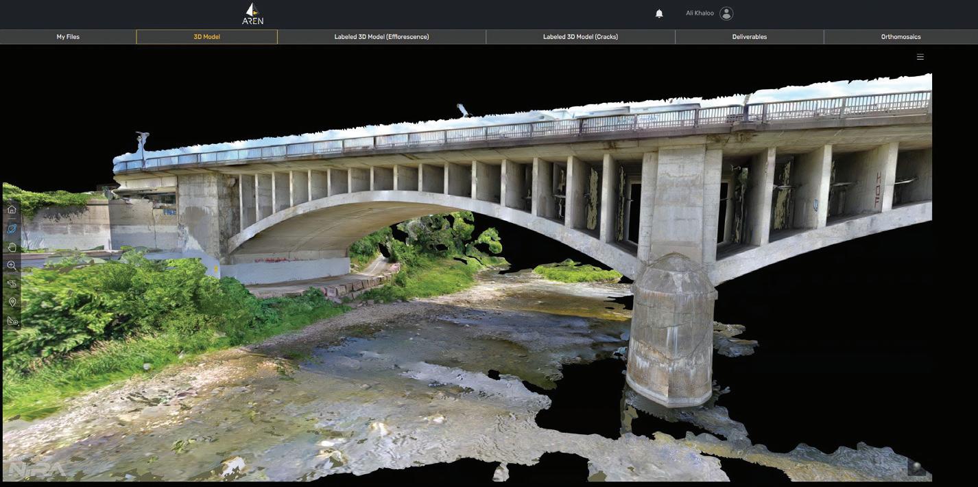
The Lorne Bridge in Ontario, Canada, where Aren used drones to capture the bridge’s imagery, which was then used to build its 3D digital twin.
Ali Khaloo, CEO and co-founder Aren.
What we need now are new data analytics tools that support engineers in this process. We need new technologies that fuse data together, integrate measurements, and provide a reliable and quantitative source of information.
And we need to be able to consider this data as a time series that changes as the asset ages. This is a considerable data science challenge, but the recent revolution in artificial intelligence has opened the door to new opportunities. That is exactly what we do at Aren by merging AI with civil engineering technology to overcome the current challenges with an innovative approach.
IN A NUTSHELL, PLEASE TELL US ABOUT AREN AND HOW IT STARTED.
Aren came out of my years of experience as an engineer and later researcher. Even as a researcher, I was always trying to look for new and innovative solutions to solve some of the pain points I faced as an engineer.
For my Ph.D., I was looking for a scalable solution that can be applied to as many structures as possible. To do so, I got inspired by two things. First, the advancements in remote sensing technologies such as camera-equipped drones and even the quality of the cameras on our smartphones. Secondly was what I saw in the medical imaging industry in which they were pushing to use AI as a diagnostic tool to analyze MRIs and CTScans to find abnormalities. So, I started to bring these technologies into the realm of civil engineering and infrastructure assessment and management.
As I started to present my work at major conferences, I saw a huge interest from different stakeholders in the industry regarding applying this technology to their assets. We then started to get grants for proof-of-concept projects across the country. That was the time that I knew that my work could become the next big thing and the only way to push the industry forward is by bringing it to the market in an entrepreneurial fashion.
WHAT WAS THE MOST DIFFICULT CHALLENGE THAT YOU FACED DURING THOSE FIRST DAYS?
Bringing new and deep technologies to any market is difficult, let alone to the infrastructure and construction industry,
which is one the least digitized industries in the world.
There was, and still is, a need to educate the market. The fact that we have a civil and structural engineering back-
ground helps a lot when we are talking to our customers since in their eyes, we know the status quo and its pain points pretty well. We literally try to change the industry from the inside out.
xyHt 14 SEPTEMBER 2023
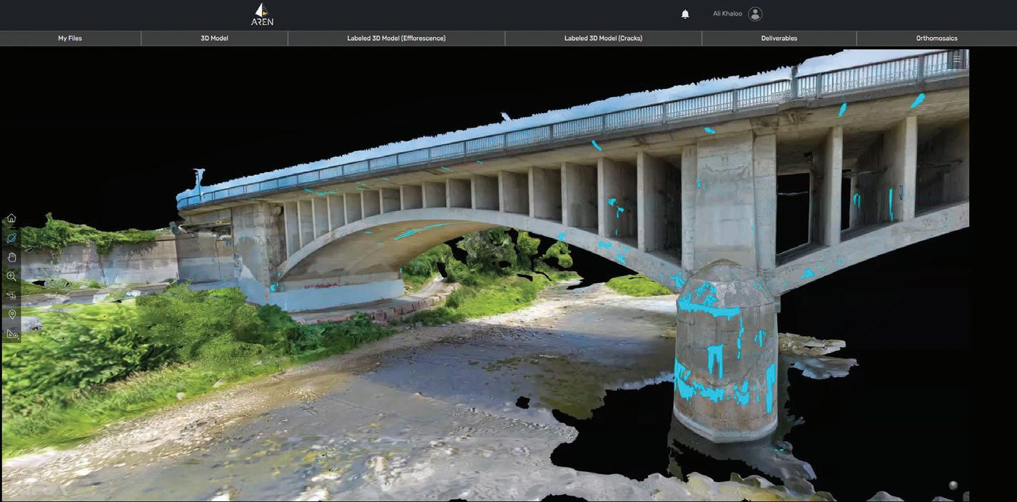
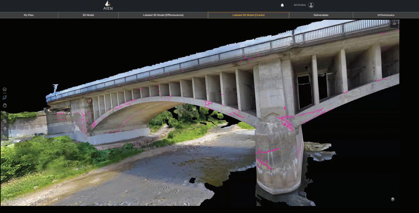
The digital twin of the Lorne Bridge as viewed using the Aren platform.
Cracks (in magenta) detected on the surface of the Lorne Bridge by the Aren platform.
Efflorescence, or deposits of salts (in cyan), detected on the surface of the Lorne Bridge by the Aren platform.
SO HOW DOES AREN MAKE USE OF AI TECHNOLOGY TO DETECT CRACKS OR STRUCTURAL ISSUES IN INFRASTRUCTURES?
For more than 10 years we have built a technology that uniquely combines computer vision, machine learning, and civil engineering. Our platform automatically aggregates raw data from different sources, such as images, video, laser scanners, and other sensors. As outputs, it provides a 3D high-resolution visualization of the asset and its health through time, as well as predictive maintenance plans, capital allocation plans, and service life estimates.
In a nutshell, we build a digital health record of the assets. Upon receiving the data, we use our AI to detect a variety of damages in the assets. And not only do we detect them, but we also quantify them and provide a severity analysis. Also, as the data gets collected over different timestamps, we are able to assess the changes in time automatically.
HOW DO YOU TRAIN YOUR AI MODEL TO DETECT STRUCTURAL DAMAGE?
Training data of civil infrastructure assets and their damages are not available as a public dataset. For instance, in the autonomous vehicle industry you have many publicly available datasets to train models. Therefore, we had to curate a large proprietary training dataset over the years, which we have used to train our AI. In addition, we have an active learning pipeline that helps us to improve the accuracy of our models over time.
TELL US THE PLACES WHERE YOU HAVE SUCCESSFULLY USED AREN.
Thankfully, we are servicing clients in North America, several countries in Europe, and all the way to Japan. So far, we have worked on different asset classes such as bridges, buildings, dams, levees, tunnels, cooling towers, industrial chimneys, and airport runways.
For instance, we helped with the condition assessment of the Lorne Bridge in Ontario, Canada. There a separate team collected thousands of imagery data using Skydio drone in an autonomous fashion. The drone enabled us to get very close to the bridge and cover the entirety of it.
Using Aren’s technology, we first built a highly accurate and photorealistic 3D digital twin of the bridge to go from images to
the full context of the asset. Later by using our AI we detected different types of damage that can happen on a concrete bridge, such as cracks, efflorescence, and spalling, some even submillimeter in size. All this damage was mapped into the 3D model to provide semantically labeled 3D models. Of course, all the damage was quantified, and we provided the severity analysis of each and every one of them.
HOW EASY CAN DRONES BE INTEGRATED WITHIN THE WORKFLOWS OF AREN?
Very easily. And the good thing is that we are agnostic to the type of drone, whether fixed wing or quadcopters, as well as their cameras. We can analyze images in the range of hundreds of megapixels and more. Drones can provide a high-resolution visual characterization of an asset analogous to what is provided by the inspection process.
The improvements in camera sensors that can be carried by drones along with the advanced obstacle avoidance systems implemented in them make drones a great tool to augment the inspection process and gather gigabytes (and in some cases terabytes) of visual data, including RGB images and infrared. Of course, the natural next step is to analyze all this data automatically and that is where Aren comes into play.
WHAT THEN IS THE TYPICAL AREN WORKFLOW WHEN DRONES ARE USED TO INSPECT INFRASTRUCTURE?
We start by helping our clients select the best drone or camera for the job. Also, we work hand-in-hand with them to find the most optimal flight path to get the most complete coverage of their asset. Then upon receiving the data on our cloud-based platform, we use our proprietary technology to create a highly detailed 3D model of the asset and by utilizing our AI, we detect and quantify the anomalies. The final deliverable package has a variety of data formats to make the life of the engineers and asset owners easier.
WHAT ARE YOUR THOUGHTS ON THE FUTURE OF AI IN THE ASSET-INSPECTION SECTOR? WILL WE SEE MORE GENERATIVE AI IN THE WAY WE ANALYZE IMAGES, WRITE PROGRAMMING CODES, AND RUN SIMULATIONS? Absolutely. We are just starting, and this is just the tip of the iceberg. Our goal is to
keep improving our tech and moving into service life estimates and recommendations on how to fix damages or design new assets with the help of AI.
WERE YOU ALWAYS PERSONALLY INTERESTED IN TECHNOLOGY AND IN BECOMING AN ENGINEER WHEN YOU WERE A KID?
I have always loved new technologies. They were the shiniest toys for me growing up. The very first thing that I remember creating as a kid was a spaghetti bridge. Bridges have a special place in my heart, and I always wanted to be an engineer and build tools and technologies to change people’s lives. The impact of the job has always been a big motivator.
AND LASTLY, IS THERE ANY MESSAGE RELATED TO THE USE OF AI AND DRONES IN ASSET INSPECTIONS THAT YOU WOULD LIKE TO SHARE WITH OUR READERS?
Psychologists have known for decades that we tend to over-trust human skills and under-trust technology. This dynamic has played out for a very long time in asset inspection and management, resulting in the impediment of advancing new capabilities. We need to change our mentalities to be more open to new technologies in our industry as a whole.
Also, it is important to realize that human inspectors aren’t going away any time soon. As we’ve seen time and again, humans have incredible capabilities when it comes to the holistic assessment of a structure. But their job is changing rapidly.
Now, the modern inspector or engineer works with highly advanced technologies, such as autonomous drones, in a difficult field environment and is tasked with handling a wider range of data for decision support and asset management. Therefore, it is completely understandable why we need the help of AI solutions to advance infrastructure asset management and, as a result, optimize taxpayers’ money and improve public safety. ■
xyHt 15 SEPTEMBER 2023
Marc Delgado, PhD, is a GIS specialist who crisscrosses continents teaching GIS in Asia, Europe, South America, and Africa.
Breaking Barriers: Next-Gen Business Software Transforms Geospatial Operations

Feature-Rich: The Capabilities of Kompass
Kompass boasts all the functions growing businesses require from an intuitive dashboard over project tracking and task scheduling right through to invoicing. As David O'Brien, the owner of SurvTech Solutions (Tampa, FL), noted, "the overall ability for me to see any project and department at any time, and check where jobs are located or to quickly pull an invoice is amazing."
nancial savings; it's about the time saved, the improved project coordination, and the enhanced data management. These factors combined contribute to a more efficient, more effective, and more profitable operation.”

Above all, Kompass provides peace of mind. It allows you to focus on what you do best: successfully completing your geospatial projects, all the while knowing that your operations are smooth, your data is managed effectively, and your projects are on track.
Revolutionizing Geospatial Businesses: Kompass BMS
Running a business efficiently is a challenging task. A plethora of disjointed software applications creates data silos and coordination issues, leading to costly inefficiencies. It frustrates both the business owners and staff who want to do their job and not be tied down by awkward processes. This is where Kompass BMS comes in.

Sailing Smooth: Kompass to the Rescue
Kompass was developed in-house by a leading European geospatial company, Murphy Geospatial and is still used by them today. The software was spearheaded by Kai Duebbert, a qualified surveyor himself and former CEO of Murphy Geospatial UK. It's a product of industry expertise and a deep understanding of the challenges of growing businesses.
Unlike other systems, which often have an accounting focus, Kompass centers on the operational business processes required by a company. Its comprehensive inte gration of all functions reduces wasted time and increases efficiency.
A Sound
Investment: The Value of Kompass Kompass isn't just a business management system; it's a transformative tool that can significantly impact your geospatial company. Customers report over 400% return of investment. Niall Murphy, CEO of Murphy Geospatial (Ireland/UK), confirms that the software has been instrumental in the growth of his company: “it's not just about the fi-
Trust in Kompass: Endorsements from the Field
Trusted by leading geospatial companies in North America and Europe such as Feldman Geospatial (Boston, MA), SurvTech Solutions (Tampa, FL), Texas Professional Surveying (Conroe, TX) and more, Kompass has proven its worth. The software is scalable, capable of handling increasing amounts of data and more complex projects as companies grow.
The Road Ahead: Kompass is the Future Kompass addresses the business struggles of geospatial companies, offering improved data management, better project coordination, and increased efficiency. To find out more or get in touch, visit Kompassbms.com.
xyHt 16 SEPTEMBER 2023
SPONSORED CONTENT
AI in the SKY
Will artificial intelligence solve the beyond visual line of sight problem for uncrewed aerial vehicles?
BY JUAN B. PLAZA
For more than a decade now we have been moving more and more processes and tasks from crewed aviation to drones in a variety of industries, but the promise of widespread massive deployment of these electrically powered wonders is still unfulfilled. The question we need to ask ourselves, the regulators, the industry, and academia is why? The reasons are many but suffice it to say that adding any new aircraft to the national airspace (NAS) is a complicated and expensive proposition and if you remove the pilot from the equation, complications rise exponentially and timing is measured in decades, not years.
The last commercial jetliner crash with fatalities in the U.S. happened in 2009 when Colgan Air flight 3407 crashed while flying from Newark to Buffalo, killing all 49 onboard and one person on the ground. Since then, the airline industry has transported more than 11 billion people safely and mostly reliably. The situation is not much different in Europe and the rest of the world where major crashes are a rarity and occupy the headlines for weeks.
So, it is understandable that civil aviation authorities throughout the world, such as the Federal Aviation Admin-

xyHt 17 SEPTEMBER 2023
istration (FAA) and the European Aviation Safety Agency (EASA) are extremely cautious to allow thousands, if not millions, of small, unpiloted aircraft to its airspace without first making sure all provisions and redundancies are put in place to guarantee the continuity of this amazing safety record.
But it will be unfair to blame the delay only on the regulators and leave the current state of the technology off the hook. Even though we all agree that we have made amazing strides over the last 10 years in terms of reliability and capability, issues such as flying times remain low, and the outlook is not much better.
Current battery technology barely sustains multi-copter flights of more than 30 minutes and with a diminished payload, and the promise of hybrid technology has not been embraced by the public at large.
Efforts to add flying time and large capacity payloads such as Parallel Flight Technology (www.parallelflight.com) in California are still in testing stages and hydrogen powerplants are facing headwinds as the highly volatile gas is difficult to store and manipulate in a safe manner. Most in the industry and academia believe that all these obstacles will eventually be conquered, but until they are, we are restricted to short flight times and restricted payloads.
Nevertheless, it is amazing what some companies around the world are accomplishing within these current limitations, by launching innovative business models that circumvent technical and regulatory limitations by adapting and complying. Examples such as Zipline (www.flyzipline.com) in Africa, Orkid (www.orkid.tech) in Colombia, and Aerialoop (www.aerialoop.com) in various countries in the Americas are plowing the field of what is to come in terms of deliveries by drone.
But, what about our mapping and photogrammetry industries? Well, the situation in this area is somewhat better in terms of advancements in sensor technology and flight times of certain types of aircraft. The advantages of using fixed-wing platforms as opposed to multi-copters is a double whammy of stability and extended flight time, resulting in increased acreage coverage, which now is getting closer to those attained with crewed aviation.
Sensor arena companies such as PhaseOne Industrial (www.geospatial. phaseone.com) have accomplished amazing miniaturization feats by reducing the size and weight of their most sensitive cameras, allowing usage in uncrewed aircraft that now can produce images of similar quality to large photogrammetric formats at a fraction of the cost.
But still, all mapping flights are restricted to compliance with the FAA Part 107 that requires flight within visual line of sight of the operator (VLOS) and that greatly reduces the number of acres that a drone can cover in a single flight.

So, when can we expect flights beyond visual line of sight (BVLOS)? That is the question that has the industry holding its breath for more announcements from the regulators worldwide. In the case of the United States, the FAA has been clear that it is already working on a new set of federal regulation codes that we suspect
will be called Part 108. This is the natural progression of Part 107, not only for the sequential nature of the numbers but because it enhances uncrewed operations from highly restrictive to more in tune with crewed aviation. What needs to happen for the regulators worldwide to accept uncrewed aviation in their national airspaces? Very simply, the technology needs to be redundant enough to guarantee the safety of the flying public as well as pedestrians and ground infrastructure.
One of the major obstacles to upgrading from VLOS to BVLOS is the fact that the controller and the aircraft will not have a direct connection between them and that creates an added degree of dependency in a third technology. Today there is direct radio communication between the operator handling the controls and the remote aircraft. In BVLOS flights that connection will have to be cellular (mobile) technology and handled by a third party, most likely telecommunications companies such as AT&T, Verizon, and T-Mobile, so these companies will be assuming a huge responsibility and that might be one of the reasons why Part 108 keeps being delayed.
The level of redundancy and emergency situations provisions that would need to be in place before any BVLOS flights are permitted are huge, and the uncrewed industry is not yet in a position to guarantee this redundancy.
Issues such as detect and avoid (DAA) have made amazing progress over the past 12 months but still is not enough to convince a regulator that it is 100 percent safe. Companies such as Iris Automation (www.irisonboard. com) have developed sensors that can be mounted onboard any aerial platform and, on the ground, to allow for better detection of incoming aircraft, thus guaranteeing safe separation between crewed and uncrewed planes.
xyHt 18 SEPTEMBER 2023
UAVs flying beyond the visual sight of their operators would change the geospatial industries like mapping and photogrammetry, but safety issues must first be more thoroughly addressed.
The last snag in this long saga on how and when to integrate these two types of aviation is the issue of air traffic control (ATC). Air traffic controllers are a pivotal part of the entire aviation ecosystem and the demands in terms of stress, fatigue, and duty time are as strict if not more strict than those required for pilots, so regulators are demanding that whatever the industry comes up with in terms of integration, it does not require adding to the workload of air traffic controllers.
The conundrum haunting the industry today is how do we add these uncrewed marvels to the sky without affecting the current safety standards, and how do we do that without coordinating with ATC?
Perhaps the answer is beginning to appear: artificial intelligence (AI). OpenAI’s ChatGPT and the widespread availability of AI tools for everyone to use could be the answer to UAV problem.
Let’s imagine for a second an unmanned traffic management system (UTM) connected to the digital components of ATC and capable of discerning when two aircraft are in a potential colli-

sion course hundreds of miles in advance, instead of just seconds before. This is the promise of AI. But given the relatively new nature of the technology, it might not be enough to significantly accelerate widespread deployment of uncrewed aircraft into congested national airspaces. At least it is giving the industry hope that help is on the way.
But the potential of AI is real, and the possibilities for a gradual deployment are tangible given the accelerated nature of its development and the sudden interest in new startups that are attracting truckloads of new investment and will surely expedite the availability of tools that can safely be used in aviation. In the not-so-distant future we will be able to load millions of hours of flights into machine learning algorithms that will create models for AI to predict and anticipate changes in routings, speeds, direction, and any other factor that might affect aircraft in flight, such as weather, unanticipated airport closures, and ground conditions.
Perhaps with the availability of these AI predicting models, a comprehensive deployment of DAA, and a solid UTM
in place we will be able, in this decade, to fly longer and higher missions and finally fulfill the promise of an industry that has been waiting for the opportunity to help humanity reduce pollution, decrease dependency on fossil fuels, improve delivery times, and expand mapping and inspection capabilities.
The next 12 months would surely deliver some good news in terms of advancement in all these technologies that are necessary for the regulators of the world to finally approve the full integration of crewed and uncrewed aviation even in the most crowed airspaces. ■
Juan B. Plaza is a drone and general aviation consultant based in Boca Raton, Florida. He specializes in the modern uses for crewed and uncrewed aviation in the areas of mapping, lidar, and precision GNSS. He is also a commercial pilot and frequently flies photogrammetry missions in Cessna Citation jets and Piper Aztec light twin.
xyHt 19 SEPTEMBER 2023
The Yurok Tribe and Condor Aviation Soaring to New Heights with RIEGL
Utilizing Airborne LiDAR in Effort to Heal the Natural World
ments,” said Michael Sitar, Airborne Division Manager for RIEGL USA.
SOARING INTO THE RENEWAL OF THE PLANET
in world history. Condor Aviation also offers airborne data collection services to support other tribal, federal, state, and local partners in the Klamath Basin and throughout the Western U.S.


CREATING A CULTURE OF PRESERVATION FOR GENERATIONS TO COME
THE RIEGL VQ-1560 II-S IS FLYING HIGH ABOARD THE CONDOR WINGS OF THE YUROK TRIBE’S NEW AIRCRAFT WITH CONDOR AVIATION.
Condor Aviation, a partnership between the Yurok Tribe’s Fisheries Department and Yurok Tribe Construction Corporation, acquired a RIEGL LiDAR sensor to collect data that will inform natural resources management decisions and environmental restoration projects on tribal land and across the western United States. RIEGL Airborne LiDAR was selected to help the Yurok Tribe achieve its mission to collect a large magnitude of high-resolution topographic data needed to support their suite of projects and partners.
“We are extremely proud to support the Yurok Tribe with remote sensing technologies that are being used in such a meaningful way to map, analyze and manage their lands and natural environ -

The Yurok Fisheries Department and Yurok Tribe Construction Corporation plan, design and implement largescale river restoration projects on the West Coast. Condor Aviation owns and operates a growing fleet of aircraft and unmanned aerial vehicles equipped with a wide range of remote sensing technologies. The RIEGL VQ-1560 II-S was recently installed in the tribal entity’s new Cessna Grand Caravan EX aircraft. The top-of-the-line LiDAR sensor, coupled with high-resolution aerial imaging equipment, will be employed to accumulate a diverse range of information regarding terrestrial and aquatic environments. The topographic and imagery data will help drive the design of the fish and wildlife habitat restoration projects, inform long-term natural resources management decisions and quantify the impact of climate change. The laser mapping system will also be used to document changes that occur on the Klamath River — California’s second longest salmon stream — after four dams are removed next year in what is considered the largest salmon habitat restoration project
The RIEGL VQ-1560 II-S by way of Condor Aviation and the Yurok Tribe’s extensive restoration toolkit is providing autonomy and positively impacting the prosperity of the Yurok Tribe. Not only are they establishing themselves as a voice in the realm of natural resources management, but they are protecting and restoring the environment for generations to come. Condor Aviation is training young Yurok citizens to use cutting-edge laser scanners and participate in the active management of their resources.
“The acquisition of RIEGL’s premier airborne laser scanning system represents the next evolution in the Yurok Tribe’s effort to transform severely degraded ecosystems into biologically diverse environments for fish and wildlife,” said Yurok Tribe Vice Chairman Frankie Myers. “The cutting-edge technology will also help us expand our restoration-based economy, enabling us to collect ultra-precise data on forest growth, snowpack, wildfires and much more for our partners across the region.”
xyHt 20 SEPTEMBER 2023 SPONSORED CONTENT
— Part 1 of 2 —
The new version of the NGS suite of Online Position User Service tools simplifies many tasks
BY PHILIPPE HENSEL
With Dan Gillins, Dan Martin and Julie Prusky
NOAA’s National Geodetic Survey (NGS) continues to improve its suite of Online Position User Service (OPUS) tools. In addition to single-point processing, OPUS offers a web-based utility known as OPUS Projects with the tools to organize, process, and adjust campaign-style surveys to the National Spatial Reference System (NSRS, Figure 1). It automatically aligns data with the latest realization of NAD 83 and NAVD 88 (or other local vertical network).
“Using OPUS Projects is a great way to process, manage, and share high-quality geo-
detic control with the geospatial community,” says Kevin Maxwell, chief of GNSS and geodetic control for the California Department of Transportation land survey office. “It can reduce time spent researching by having data in a nationally maintained, recognized, and accessible online location. We recommend its use whenever geodetic control is involved in a project.”
IT’S ALL ABOUT GEODETIC CONTROL
Single OPUS-Static (or Rapid-Static) solutions submitted to the OPUS upload page (Figure 2) are fine if you need to check your survey control or create
positions that are relative to the NSRS. But if you need to establish geodetic control, meaning establishing authoritative positions and heights with known network and relative (local) accuracies, then you need more than just a check. You need OPUS Projects. OPUS Projects also provides an easy way to submit your campaign data to NGS for inclusion in the Integrated Database (IDB). By doing so, not only are you providing authoritative coordinates with estimated relative and network accuracies published on NGS Datasheets, but you are contributing to
xyHt 21 SEPTEMBER 2023

the improvement of NGS models and tools you rely on.
RELATIVE (LOCAL) ACCURACY
OPUS Projects will provide you with robust estimates of relative accuracy as a result of constrained least-squares adjustment of GPS-derived baselines between Continuously Operating GNSS Reference Stations (CORSs) and user-observed marks in a survey network. It processes all of the baselines simultaneously, accounting for all correlations in the observations from the satellites at the time of the survey. Not only does this help remove common mode errors, but those correlations provide the estimates of relative accuracy.
NAVD 88
If heights in your local vertical datum (NAVD 88 for the continental U.S.) are important to your survey, by tying and constraining directly to bench marks and other high-precision orthometric heights, OPUS Projects can produce heights with high relative accuracies. Since the origin of “Height Modernization” surveys in the 1990s, NGS has supported the use of GPS-derived orthometric heights to densify the NAVD 88 network. The user is directed to the OPUS Projects User Guide for more information. Other vertical datums supported include PRVD02, NMVD03, GUVD04, VIVD09, and local (tidal) datums.
ALIGNMENT TO THE NSRS
OPUS Projects ensures your entire survey control network is tied consistently and accurately, both internally and externally, to the NSRS. As with all OPUS products, you are ensured that your solutions are
using the very latest hybrid geoid model, the latest Horizontal Time-Dependent Positioning (HTDP) model, and are referenced to the correct State Plane Coordinate System (SPCS). Many Real-Time Network (RTN) Managers are using OPUS Projects to align their networks to the NSRS. Similarly, local surveyors can
the latest realization of NAD 83 and NAVD 88 (and other vertical datums: PRVD02, GUVD04, VIVD09, etc.). Users can easily upload their survey mark description files, scanned field log sheets, digital photographs, and a digital final report, and with the click of a button, submit their entire project to NGS for review. Upon successful review, new or updated datasheets for the survey marks will be published on NGS datasheets, establishing authoritative geodetic control where you need it. Data that you submit will be used by NGS to help develop models and tools, and provide valuable geodetic control thereby expanding and validating NSRS stations.
RTK DATA
use OPUS Projects to align their survey control to the NSRS easily and simply using its intuitive, user-friendly interface.
PUBLISHING YOUR DATA
If your work requires you to set authoritative geodetic control using GPS, then look no further than OPUS Projects. In its latest version (currently OPUS Projects 5), users are able to follow a tried-and-true sequence of geometric and vertical adjustments, bringing their network in alignment with
A new enhancement is also available in OPUS Projects 5, which allows users to upload their Real-Time Kinematic (RTK) vectors into their project. This advanced capability is made possible using the new GNSS Vector Exchange (GVX) file format. Users can now reap the benefits of adding RTK vectors with their static GNSS occupations in a least-squares solution. This new capability will support submission of the entire project to NGS for review, and the potential for the efficient creation and updating of official geodetic control.
IT’S SIMPLE AND EASY
OPUS-Projects provides very intuitive data organization and visualizations, but it also incorporates a number of very useful features:
• CORSs that were used in the individual OPUS-S solutions are automatically included in the project. You can also easily
xyHt 23 SEPTEMBER 2023
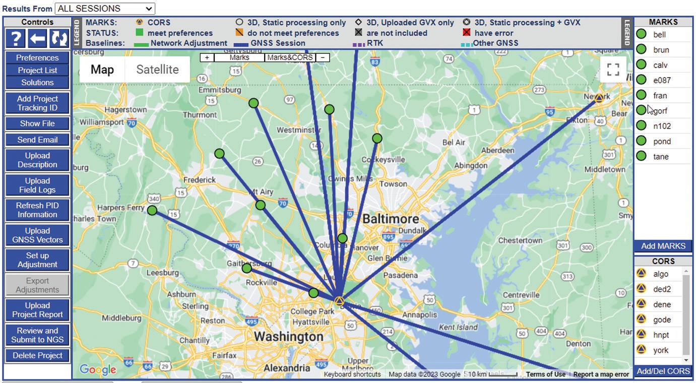
Figure 1: Example of a project shown on the OPUS-Projects Manager’s Page after all observation sessions have been processed.
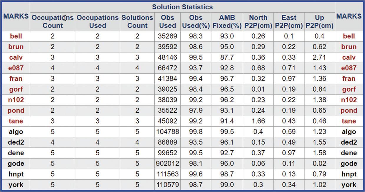
Figure 2: Solution statistics from a sample OPUS-Projects project, providing percent observations used in the solution, the percent ambiguities fixed, and “peak-to-peak” error estimates (among other statistics).
select other CORSs, screening them by their performance characteristics. OPUS Projects computes positions simultaneously on not only your observed survey marks, but also on the CORSs. By comparing computed positions to the CORSs’ published positions, you can quickly see if there are disagreements with either your own survey control or possibly even with the behavior of a particular CORS on the day of observation.
• OPUS Projects pre-selects the NGS-recommended “hub-and-spoke” design for your network, picking the most central CORS within your project as the hub, with spokes radiating out. Of course, the user can specify any number of other network designs.
• OPUS Projects guides you through a sequential set of five least squares network adjustments, providing the necessary information to validate the results of your survey. Each step of the way, OPUS Projects recommends the necessary constraints. If you have uploaded a description file to the project containing survey marks with published NGS Datasheets, OPUS Projects
will use the official positions and/or heights in the project.
• OPUS Projects vastly simplifies the process of submitting a GPS survey to NGS for publication. The entire process of “bluebooking” is now behind the scenes, and all the user has to do is follow the sequential steps of network adjustments and upload the supporting files.
PROFESSIONAL RESULTS
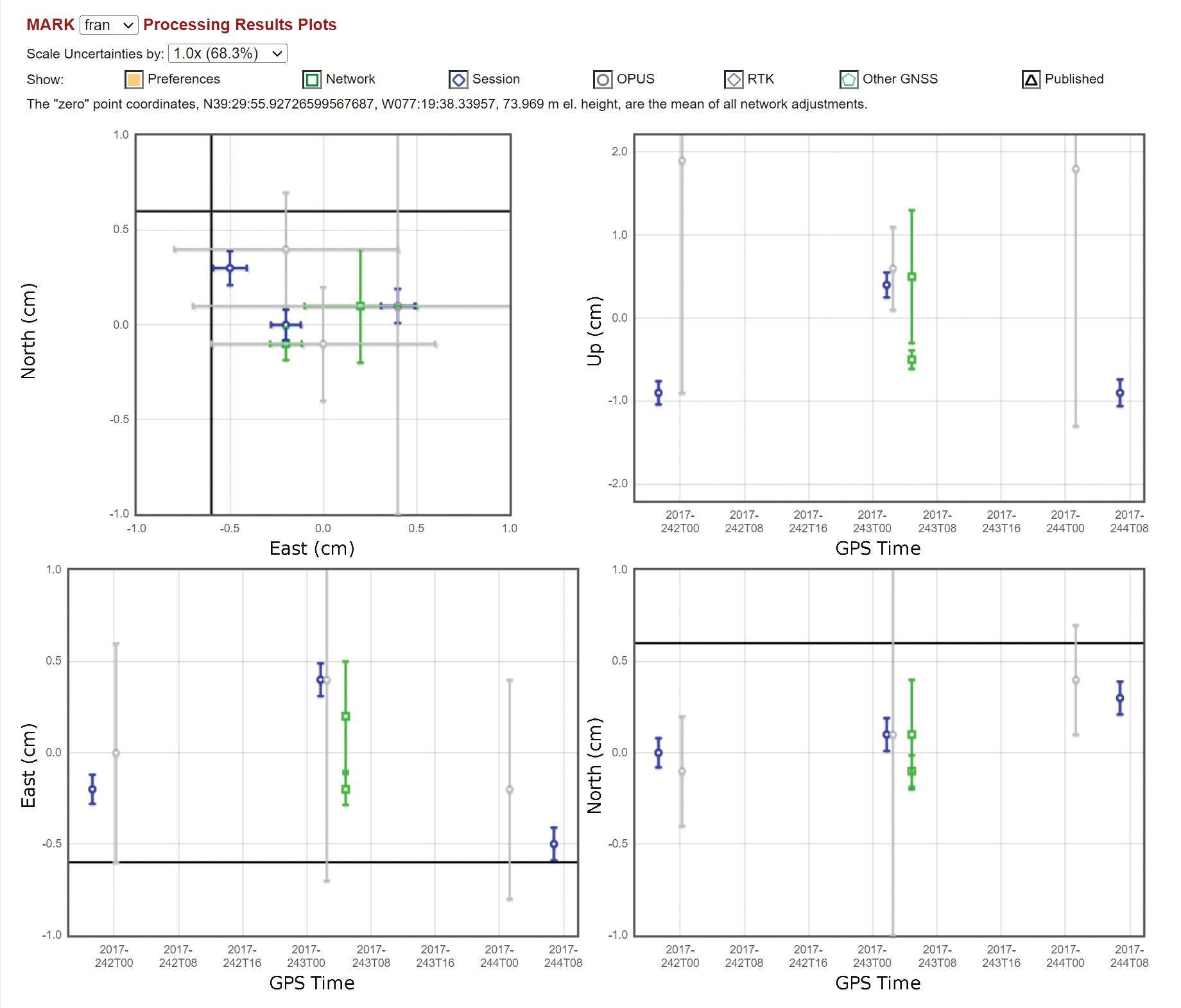
OPUS Projects provides a broad palette of results. For many users, the graphic visualizations and tables provided within the OPUS Projects web interface will be a good starting point for further analysis. Figure 3 shows part of more detailed analysis of processing results for a particular user mark (assigned the four-character ID “fran”).
For the user interested in submitting the project to NGS for review and publication, a number of output files are available for review. These output files are available from within OPUS Projects (by clicking on the “Show Files” button), as well as within the email attachments
automatically sent to the project manager.
The Processing Report contains the all-important shifts from published control that the user will want to scrutinize.
RESOURCES
Currently, to gain access to OPUS Projects, an instructor-led class is required (in-person or online). A schedule of upcoming classes is available on the NGS Testing and Training Center’s calendar. Very soon, NGS will provide self-paced training tutorials, which will remove this requirement. Additional resources include training videos and a comprehensive OPUS Projects User Guide to support both novice and advanced users. The document begins with a Quick Start guide for users already familiar with the software. For those less familiar, the rest of the 200-plus page manual gently guides the reader through all phases to help ensure a successful project, from project design, the submission of a project proposal to NGS, to CORS selection, session processing, and network solutions.
CONCLUSION
If you are running a GPS survey, and high relative accuracy, alignment of your network to the NSRS, including NAVD 88, and the establishment of official geodetic survey control are important to you, consider using OPUS Projects. OPUS Projects is easy to use and has a wide array of intuitive and graphical output, as well as in-depth results. The latest version has simplified many tasks, especially if you are interested in submitting your project to NGS for review and publication. ■
Philippe Hensel is the supervisory geodesist with NOAA’s National Geodetic Survey and project analysis branch chief. Dan Gillins is an NGS geodesist. Dan Martin is Northeast Regional Geodetic Advisor for NGS. Julie Prusky is an NGS geodesist.
xyHt 24 SEPTEMBER 2023
Figure 3: Solution statistics plots for a given mark (“fran”) in an OPUS-Projects project, showing three-dimensional uncertainties associated with individual OPUS-S solutions (gray lines), session processing (blue lines), and network adjustments(green lines).


xyHt 25 SEPTEMBER 2023
Part One:
What’s Inside YOUR GNSS ROVER?
to examine all aspects and variations of the types of antennas built in or connected externally to rovers. However, there are some common fundamentals.
Gavin Schrock
The work of a surveyor requires a lot of independent verification and being able to show how they arrived at a conclusion. It takes a lot of faith in a tool like a GNSS rover, the inner workings of which remain a bit of a mystery. However, through decades of use, development of best practices, and a growing understanding among surveyors of the science of GNSS, many surveyors have accepted rovers into their workflows.
There have been a lot of different design ideas over the past two decades, a lot of different approaches (and some gimmicks). After all, we don’t see things like gull wing doors on many cars, despite them being “cool” features of the DeLorean and
some Mercedes. Presently, the culmination of a lot of parallel development has resulted in a kind of dominant design, in form factor and inner workings. Function has made modern GNSS rover heads look a lot alike, inside and out, and perform a lot alike.
But how does that thing really work? There are many types of GNSS receivers/ antennas for a wide range of applications, however, this article is focused on GNSS rovers for surveying, construction, and asset mapping.
FROM THE TOP
If we start where the path of the satellite signals begins in the rover, the antenna is the most recognizable element of the design. It would take a whole separate story
Typically, surveying and construction rovers employ patch style antennas. The patch can be a small ceramic square in the middle of a ground plane. There are lots of variations: pinwheel style, some with rows of “teeth” around the edge, and non-patch alternatives, such as helical antennas. The various designs seek to optimize reception, exclude outliers and multipath, and, where applicable, continue to work well when tilted.
With patch antennas, there may be one or more contacts, or “pins,” that feed into the receiver. In the past you may have used a legacy L1-only rover that might have had only one contact. The bandwidth of a single contact is very narrow, adding a second increases bandwidth, can be designed for multi-axis, and opens up more options.
To receive the many bands of signals that four or more constellations broadcast, the rover antenna design will typically include multiple, stacked patches. “It is less about the constellations and is more about frequencies,” said Dr. Stuart Riley, vice president of

xyHt 26 SEPTEMBER 2023
The venerable GNSS rover, has evolved into an essential part of a surveyor’s toolkit, although some mystery remains as to what that magic box does and how it does it. To demystify this, we engaged GNSS engineers to help craft this three-part “explainer” series.
Technology/GNSS at Trimble. Riley has been in GNSS design and engineering for 28 years and now leads the teams responsible for various elements of GNSS products for surveying, construction, agriculture, and more. For instance, his team designed all elements of the R12 and R12i rovers.
“The antenna does not care whether the signal is GLONASS, GPS, Beidou, Galileo, etc. What is important is to understand and design for the frequency/bandwidth of these signals,” said Riley. “Think about L1, MSS (like RTX), and several Beidou signals. Those are roughly in a similar band, then there is a bit of a gap, then L5, E6, and more signals clustered together. So typically, we have a couple of patches.”
Much of the antenna is passive. However, if you are also including the low-noise amplifier (LNA), the antenna assembly (element + LNA) does draw power. A tiny amount of power is supplied to the antenna from the receiver to power those active components (more on that later).
You may remember large ground planes in the past. They seem to have shrunk, along with the rovers they are paired with or built into. Just how small could a ground plane be and still be effective?
“Usually, the antenna ground plane diameter should be no less than about half of the target radio frequency (RF) wavelength,” said Ce Huang, research and development director at Tersus GNSS. “For a GNSS antenna, the RF signal wavelength is 0.19m for L1 and about 0.25m for L5. So, I figure the lower limit value is around 0.1m.” And indeed, we now see a lot of the new wave of small rovers that are about 10cm, or four inches in diameter.

“Much of the physical size of a rover is dictated by the antenna element,” Neil Gerein, long time GNSS engineer who is now vice president of marketing at Hexagon’s Autonomy & Positioning division. “You need to have a couple of things in the antenna: very good phase center offset (PCO) and phase center variation (PCV). And that's the electrical characteristics on the antenna so that the electrical
phase center is very stable for the precise measurements that the rover needs. And the other thing is the overall size of it, you want to get as much electromagnetic energy from the signal. That helps dictate the size, and it also dictates the amount of multipath rejection you have from the satellites.”
Gerein explained that a key factor in multipath rejection is that the signals have a right-hand circular polarization. If signals bounce off of a building or something nearby, the signal could arrive with a lefthand circular polarization.
“You want to reject those and low-elevation multipath. Good rejection of left-hand circular polarized signals, good PCO and PCV, as well as being able to receive the signals on all frequencies,” he says.
But how can an antenna continue to perform well when tilted? In designing rovers for no-calibration tilt compensation, in some instances, there have been design changes made to antennas. For instance, Leica’s GS18 T, the first of the no-calibration tilt compensated rovers released five years ago, incorporated a new antenna variation to continue to track many satellites when tilted.
“There are two things we have put to special consideration when designing a rover antenna for tilt compensation,” said Huang. “The L1/L2 phase center distance. When doing tilt measurement, the traditional methods of compensation of the L1/ L2 phase center offset (PCO) vertically (for RTK solutions) are not suitable anymore. One solution is trying to design the rover antenna with L1/ L2 phase centers very close to each other (about 1~2mm). Then
you don’t need to know the tilt angle very precisely to compensation the L1/L2 PCO.”
The other, Huang said, is elevation mask. “Usually, a GNSS antenna has elevation mask at 0 to 10 degrees. That makes sense when the antenna is vertical. In tilt measurement, we expand the elevation mask to -10 to -20 degrees, so the antenna can still receive signals from all directions when it’s tilted up to 30 degrees.”
HOUSING
Round, square, small, or large? “Burgeron-a-pole,” “chicken bucket,” “lunchbox,” “discus,” “carrot,” “bullet.” The various form factors of rovers get described in many ways. Sometimes, integrated receiver/antennas are called “smart antennas.” Why are particular form factors chosen?
GNSS developers have told me that it is mainly due to what they are putting inside. Namely, how to make room for the various boards, battery compartments, IMUs, cameras, radios, WiFi and Bluetooth modules, and, if applicable, extra slots to enable battery hot-swaps. More features often mean a larger rover, however, there are continual improvements in miniaturization. A rover’s small size may not mean it will necessarily be less capable. The form factor and housing are also designed to reduce the impacts of shock and environmental factors.
“What we do at the receiver card area is we build it to be able to handle that shock and vibration,” said Gerein. “Of high importance is the reference oscillators. If you start vibrating those, that affects the entire solution. In our case, it’s on our receiver card: the temperature compensated crystal oscillator (TCXO), and in all our OEM receivers, they’re all set up for high vibration and shock. For
xyHt 27 SEPTEMBER 2023
There are many different approaches to antennas designed for rovers, including a typical stacked-patch (left) – Image credits: G. Schrock
There is a lot of hardware and software magic going on inside a typical GNSS survey rover.
a rover on a pole, as you move it pointto-point you hit that pole on the ground. That can create a vibration on the oscillator. And if you don't account for that, it will work its way straight into the carrier phase measurements.”
Most high-end rovers have sturdy alloy housings. These are important to protect what’s inside and are designed to withstand drops from standard pole heights. There can be many seals to achieve IPV66, 67, and 68 ratings for dust and moisture.
As one designer said, the solid housing was actually challenging to create to meet design goals, and to also be cost effective. Square-ish designs, some say, can more easily accommodate faceplate style user interfaces, though these are sometimes added to round housings. Some say that round designs and rovers with helical antennas do not snag as much when carrying them thorough dense vegetation (though I find any shape seems to).
We are beginning to see more rovers with helical antennas. While there are numerous papers contrasting the performance of helical vs. flat, there appears to be much nuance in considering the advantages or disadvantages of each.
There could be specific applications in mind when choosing one or the other. For instance, one of the considerations Bad Elf said it had in choosing a helical antenna for their Flex rover was to make a sleek form factor, that GIS and asset mapping users could more easily push up through vegetation.
We do not suggest that you purposely do a drop test of your rover. But rest assured that the manufacturers have. Even most plastic-housed rovers can withstand the impact of a pole blowing over, and the head hitting the ground. One manufacturer showed me a video of one of their alloy-housed rovers being smacked against a brick wall, yet it still continued to operate.
AMPLIFICATION
A GNSS satellite 20,000 km distant, with a limited power budget, is broadcasting signals that are quite weak by the time it hits a rover. Amplification is employed to enable the signal to stay strong and consistent through the many paths it needs to take within the rover.
Low-noise amplifiers (LNA) are an active component within external and integrated rover antennas. There are multiple signals coming in, within various frequency bands, so there may be multiple LNAs.
“You amplify the frequencies individually. For example, in the antenna/LNA you cannot separate GPS L1 from Galileo E1, the signals are on top of each other. Instead, you amplify the L1/E1 band,” said Trimble’s Riley. “You amplify before sending them through a single antenna cable if you’ve got a separated antenna and receiver.
“In the case of a smart antenna, we typically don’t combine and so we’ll have multiple feeds coming down to the GNSS board. The LNA is critical for two things: First of all, you could lose the signal in the noise, so if you don’t amplify before you start losing, you’ve lost it for good.”
His example was where you might have a 1-, 2-, or 3-dB loss from the combined elements of the antenna, you would lose that for good and there’s nothing you could do about it. Therefore, by having some gain upfront you prevent that effect.
“And secondly, it’s critical for robustness,” added Riley. “Making sure that that amplifier is not going to be saturated by out-of-bounds signals, such as Ligado and other signals is critical.”
The LNA are physical devices, and there may also be physical filters. There are many types, such as ceramic, cascade, and even large-cavity filters (though the latter may not be common for rovers). The most common application for filters is to simply minimize out-of-band signals, to ensure that only desired signals are then amplified.
It can be a delicate balance. It is possible to over-design and filter too narrowly. For military-grade antennas designed for use in areas of jamming and spoofing, the design approaches and use of filters is far more complex than in a standard commercial rover.

“Detection and mitigation of interference can be done in many places, starting with the antenna, the amplifier, and first stage filters,” said Gerein. “To keep and receive just the signals you need to process in the bands of interest for GNSS, you can design the antenna for this and add hardware filters that keep out strong adjacent band interference. And as you transition into the next stage of high-speed signal processing, you can add a stage of digital filtering, which you might not have had 20 years ago. You can filter out at the start, then cascading down as you get into the digital realm, with digital filtering to tighten that up and help keep out those interferers.”
Gerein has helped engineer and design receivers and antennas specially for interference detection and rejection for the defense sector.
As the signals from the satellites are analog, the next step in getting the signals to the receiver is the analog to digital converter (ADC). Following that step, things can get quite a bit more complex. ■
Continued in Part Two, xyHt October 2023 issue.
Gavin Schrock is a professional land surveyor who writes on many topics, including surveying, mapping, GIS, data management, reality capture, satellite navigation, and emerging technologies.
xyHt 28 SEPTEMBER 2023
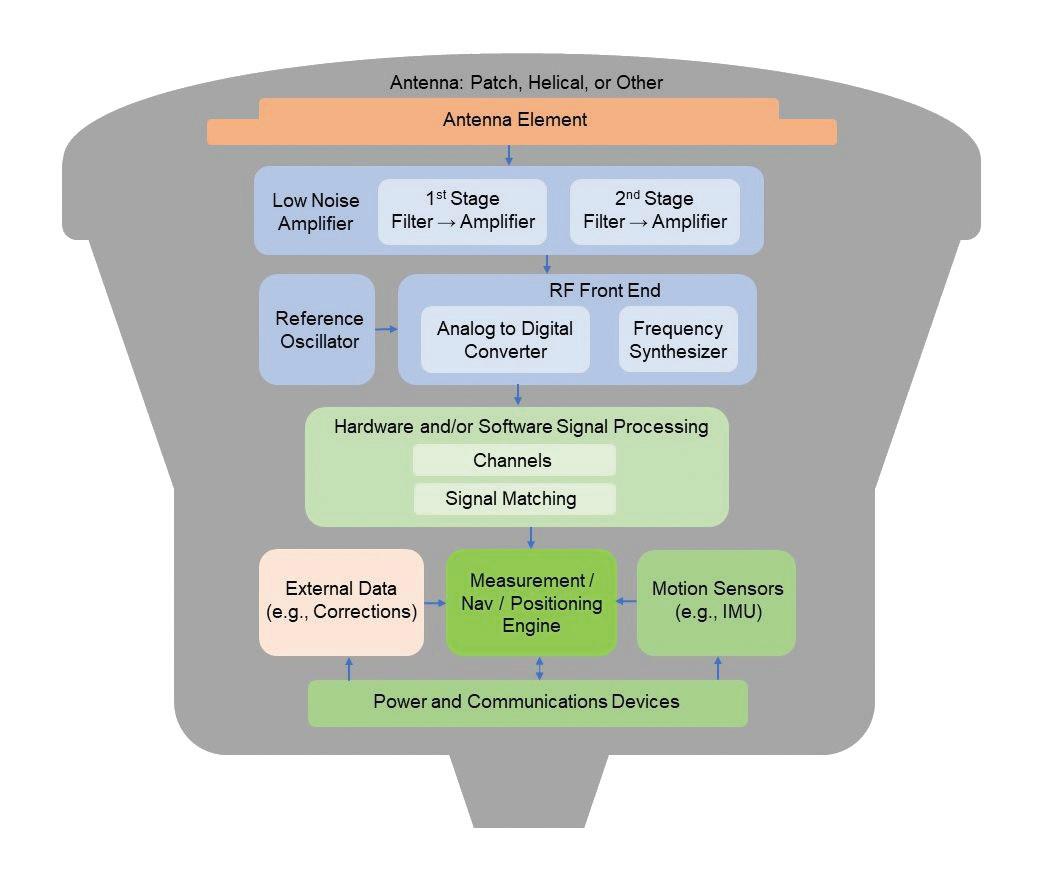
Block diagram of a typical GNSS survey rover. While there are various approaches to rover design, there are some common and essential elements. Of course, this is not to scale. – Graphics: G. Schrock
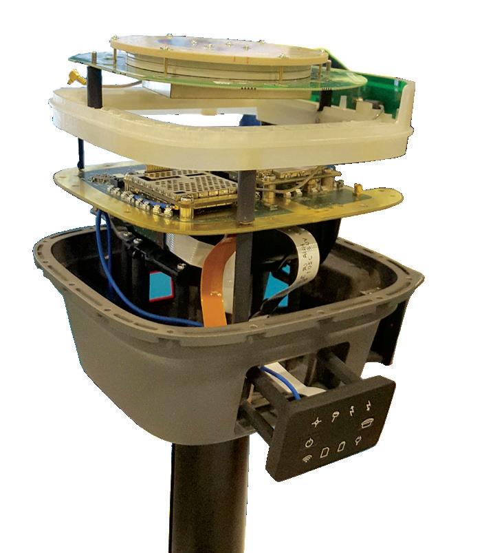
Rover housings being prepared for assembly at a GNSS factory – Image credit: G. Schrock
Instrument Repair Education
College of the Canyons
Land Surveying
26455 Rockwell Canyon Road
Santa Clarita, CA 91355 (661) 362-5096
Email: Regina.Blasberg@canyons.edu
Website: www.canyons.edu/SURV
Associate of Science Degree Courses offered ONLINE (Video Conferencing)

New Mexico State University
Geomatics Department
Equipment
Instrument Repair
Navigation Electronics, Inc.
124 Toledo Drive Lafayette, LA 70506
(337) 237-1413
Website: www.neigps.com
Georgia Office: (770) 729-8005
Alabama Office: (256) 665-5589

Mississippi Office: (662) 347-1117
Arkansas Office: (870) 273-6333
Florida Office: (850) 228-2070

Seiler Instrument Geospatial Offices in IL, IN, KS, KY, MI, MO, NE, WI 877-330-6303

Positions Available
Email: servicedept@seilerinst.com
Website: www.seilergeo.com
1060 Frenger Mall – Room 130 Las Cruces, NM 88003
Phone: (575) 646-6748
Email: kwurm@nmsu.edu or elaksher@nmsu.edu
Website: https://et.nmsu.edu/geomaticssurveying//
Fully online program and +2 option.
BS Degree
Troy University
Surveying and Geomatics Sciences Program
Geospatial Informatics Department
344 Wallace Hall Troy, AL 36082
Phone: (334) 808-6727
Fax: (334) 670-3796
Email: geospatial@troy.edu
Website: www.troy.edu/geospatial
BS Degree, ABET-ASAC accredited www.instagram.com/troygeospatial www.tiktok.com/@troy_geospatial

University of Maine
Surveying Engineering Technology Program 5711 Broadman Hall, Room 119 Orono, ME 04469-5711
(207) 581-2340
Email: um.set@maine.edu
Website: http://www.umaine.edu/set/svt/ Bachelor Degree. abet-taac
xyHt 29 SEPTEMBER 2023 CLASSIFIED ADVERTISING CONTACT ANGIE DUMAN TO PLACE YOUR AD
Stay Connected www.xyht.com Contact Angie Duman to place your listing here!
angie.duman@xyht.com
Testifying As an Expert
 By Jeffery N. Lucas, JD, PLS, Esq.
Aboundary dispute case, or any case involving surveying, surveyors, landowners, and property rights (“property disputes”) is a different breed of civil litigation from most others. There are many unique aspects of this type of litigation not common to other cases.
The biggest difference is that the parties are paying for the litigation out of their own pockets. Unlike personal injury cases, there is no insurance money to pay the freight. If there were, then the litigation over property disputes would explode, and you would start seeing my face on TV commercials during reruns of “Green Acres” and hear my voice in ads on the “Paul Finebaum Show.”
That’s how often these disputes come up, but the vast majority never launch because of the money issue.
Don’t get me wrong, the title insurance companies can and do get involved— sometimes. However, they are insurance companies, and the first knee-jerk reaction of all insurance companies is to deny coverage, it’s in their DNA.
Nevertheless, when they do get involved, the money is limitless and if they are coming after you there will be four lawyers at the table with 160 years of combined experience and you will be on the other side sitting with your E&O assigned lawyer, freshly minted with a bar card and no clue what surveyors do. It could be that you may be testifying in your own defense, and you don’t have a clue either. Good luck with that.
Most of the time these cases go before a judge without a jury because the
attorneys know enough about surveying and surveyors that they are concerned the jury will not understand the case. This is because, as a profession, we have made surveying so esoteric with our arbitrary rules and nonsensical procedures, that even surveyors can’t explain it.
So, your next biggest hurdle is the judge may not understand the case either, or it could be the complete opposite. The judge may have had so many bad experiences with surveyors who come to court unable to explain what they did or why they did it, that the judge sees the entire profession as incompetent.
“The Court does not believe that Mr. Brackman [the surveyor] established, to any degree of certainty or clarity, why he arrived at his opinion. The only markers he referred to were old survey stakes of which he did not know the age or origin. He acknowledged not having any specific deed language and/or natural monuments to go by and did not give credence to any artificial monuments. The Court is puzzled about what he relied upon, and without
more, does not accept his survey as authoritative regarding the property boundary.” Weber v. Kroeger, Tenn.App. (2019).
The lack of money can have many unfortunate consequences. As an expert, you want to know what the other side is thinking and what the other side’s expert is going to say before it is said. The only way to do this is through the discovery process. The best discovery is through depositions, but wait, depositions cost money, so they may not happen. If the pockets are relatively deep, they will do depositions and you may be able to sit-in on them. You want to do that if possible. By the same token, their expert will be able to sit in on your deposition.
Depositions aren’t the only form of discovery. You want to see everything the attorneys will let you see. Certainly, all forms of documentation, deeds, maps, plats, etc. Also, deposition transcripts even if you sat in on the deposition. The court reporter made verbatim notes, you didn’t. You also want copies of the complaint(s) and answer(s). This is where the attorneys make their arguments about the case.
When discovery is finished and you are going to trial (which, often does not happen due to a settlement or lack of money), you only have one job as the testifying expert. The judge doesn’t want to be there, so your job is to show the judge the way out of the case. And the way you do that is to explain to the judge, in normal human language not as an alien from the planet Pincushion, what was done and why it was done.
The purpose of this column is to encourage your questions on boundary surveying issues that we will address in future installments. As such, you are invited to send your questions to the editor of xyHt
Jeff Lucas is an attorney and land surveyor in private practice in Birmingham, AL. Jeff is an author, columnist, lecturer, seminar presenter, and continuing education provider. He writes a monthly newsletter, The Lucas Letter , dealing with legal issues and the practice of surveying. More information about Jeff and his continuing education courses can be found at: www. lucasandcompany.com
xyHt 30 SEPTEMBER 2023
LEGAL BOUNDARIES