The AgriPost
June 26, 2026
1
‘
Extreme June Weather Leaves Some Manitoba Fields Under Water By Harry Siemens A special June 17 edition of Manitoba Agriculture’s CropTalk opened with a clear message for farmers: Manitoba’s weather changed quickly, and some areas now face serious crop damage. Alison Sass, Ag Meteorology Specialist with Manitoba Agriculture, said May started cool across much of the province. Many areas experienced later-than-normal seeding, with only a few warm days mixed in. But by early June, the situation changed dramatically. Sass said the most severe weather came on June 9 and 10, when long-lasting storm systems moved across Manitoba. She described the storms as powerful, slow-moving and unusual because of how long they lasted. “These are not all just isolated storms,” she said during the webinar. “It’s a system after system after system.”
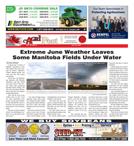
Standing water covered large sections of some Manitoba fields following the June 9-10 storms that delivered record rainfall in parts of the province.
Manitoba Agriculture’s weather station network captured the historic rainfall totals and storm activity reported during the June 9-10 weather event. Photo: Manitoba Agriculture.
The storms brought intense lightning, strong winds, tornado warnings and major rainfall. Sass said the southern Interlake, Red River Valley and eastern Manitoba took some of the hardest hits. Stonewall recorded 255 millimetres of rain in just 14 hours. Petersfield recorded 230 millimetres, and Woodlands, Teulon
and Dugald also received heavy rainfall in a short period. That much rain, Sass said, caused overland flooding, full ditches, flooded basements and fields that now look more like lakes than crops. The storm system also produced confirmed tornadoes near Dufrost and Ste. Anne. Sass said the rainfall quickly
changed Manitoba’s moisture picture. Areas that had looked dry only two weeks earlier shifted to above-normal precipitation. The northwest and Interlake now show very wet conditions, while parts of the southwest remain on the dry side. She cautioned that percent-of-normal rainfall maps do
not tell the whole story. A field may show near-normal rainfall on paper, but if most of that rain came in one heavy event, it may not benefit the crop. Current soil moisture readings show wet to very wet conditions across much of Manitoba in the top 30 centimetres. Deeper soil moisture readings also show very wet areas around Teulon,
Stonewall and parts of eastern Manitoba. Looking ahead, Sass said Environment and Climate Change Canada forecasts show a 50 to 70 per cent chance of above-normal temperatures from mid-June to mid-July. The same forecast gives a 50 to 70 per cent chance of below-normal precipitation during that period. For June, July and August, temperatures are also trending above normal, while precipitation remains uncertain. Sass reminded producers to use Manitoba Agriculture’s current weather viewer for hourly station data. The system now includes precipitation totals for the last hour, last 24 hours and since the beginning of the month. She also thanked the AgMet team and station landowners who keep the provincial weather network operating. “These are the moments when we really need to capture what is happening,” Sass said.