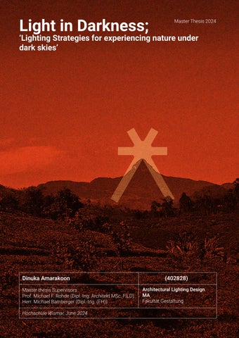
Lighting in Darkness; 'Lighting stratergies for experiencing nature under dark skies'
Light in Darkness; ‘Lighting
Strategies for experiencing nature under dark skies’
Dinuka Amarakoon (402828)
Master thesis Supervisors
Prof. Michael F. Rohde (Dipl.-Ing. Architekt MSc, FILD)
Herr. Michael Bamberger (Dipl.-Ing. (FH))
Hochschule Wismar, June 2024
Architectural Lighting Design MA
Fakultät Gestaltung
Light in Darkness;
‘Lighting Strategies for experiencing nature under dark skies’
Dinuka Amarakoon (402828)
Master thesis Supervisors
Prof. Michael F. Rohde (Dipl.-Ing. Architekt MSc, FILD)
Herr. Michael Bamberger (Dipl.-Ing. (FH))
Hochschule Wismar, June 2024
Architectural Lighting Design MA Fakultät Gestaltung
Acknowledgement
First and foremost, I extend my heartfelt thanks to my two supervisors, Prof. Michael F. Rohde and Herr. Michael Bamberger. Their expertise, patience, and insightful feedback were invaluable to the completion of this thesis. I would also like to acknowledge Hochschule Wismar for providing the resources and facilities throughout my studies. Also, to Prof. Jan Blieske, Prof. Thomas Romhild and Mr. Bipin Rao for their guidance through four semesters of study in Hochschule Wismar.
would also like to express my gratitude to Ama for unwavering support through thick and thin, and to the survey team and friends who supported; Rajika, Thimira, Dulaj, Janaka, Mahesh, Hirantha, and Chandima. Also to contributors with their insights on the context; Dewasmitha Pathirana, Lanka Rasadi, Amila Prasanna Sumanapala and Sanoj Wijayasekara.
am forever indebted to my family, especially my parents, and brothers and their unconditional love, patience, inspiration and their unwavering support throughout my life. It is absolutely a must to remember the roots. would like to express my deepest gratitude to all those who have supported and guided me throughout the course of my life. To mention, everyone that have shaped me in schooling days at St. Sylvester’s College, Kandy and Dharmaraja College, Kandy. And higher education at University of Moratuwa, Sri Lanka; where completed my Bachelors in Department of Integrated Design.
Thank you all for your incredible support and encouragement. This thesis and this journey would not have been possible without you.
Lastly, would like to dedicate this to all that is on the island of my origin. To all the amazing beings. To all the stories and to every bit of greenery, grain of sand and drop of water.
Der dunkle Himmel ist eine Erfahrung, die der Mensch im Laufe seiner Geschichte gemacht hat. Und dennoch ist die Erfahrung von Dunkelheit und Sternenhimmel im Moment eine sehr seltene oder eher nicht existierende Erfahrung in unserem Leben. Das liegt vor allem an der Lichtverschmutzung. Und Gebiete mit dunklem Himmel bleiben abgelegen und sind für den modernen Menschen nicht zugänglich, so dass die meisten von ihnen den dunklen Himmel nie erleben werden.
Bei diesem Projekt geht es um eine nächtliche Wanderaktivität in Sri Lanka, bei der Pilger nachts zu einem Berggipfel (Adam's peak) in einem Naturschutzgebiet wandern. Es ist ein Versuch, das Forschungsproblem "Wie kann man das nächtliche Wandern in natürlicher Umgebung mit einem verantwortungsvollen Umgang mit Licht verbinden?" zu erforschen. Die anfängliche Forschung betrifft verschiedene Bereiche, wie skotopisches Sehen, funktionelle Aspekte des Lichts beim Nachtwandern, Licht und nächtliche Wildtiere, Dunkelheit und menschliche Erfahrung. Die Vision des Projekts ist es, die Möglichkeit von Erfahrungen zu erforschen, die ein soziales Bewusstsein für das Ausmaß der Lichtverschmutzung und ihre ökologischen Auswirkungen schaffen und somit letztendlich einen sozialen Wandel ermöglichen.
Das Projekt wird als Pilotprojekt durchgeführt, um Möglichkeiten für nächtliche Wanderungen in Umgebungen mit dunklem Himmel zu erforschen, und zwar durch ein umfassenderes Verständnis der Anforderungen, die der ausgewählte Ort stellt, durch eine Studie über die Persönlichkeit der Nutzer und durch verantwortungsvolle Beleuchtungspraktiken.
Die Ergebnisse dieser Studie werden uns einen Einblick in die praktischen und konservativen Möglichkeiten für menschliche Aktivitäten in der Natur unter dunklem Himmel geben. Letztendlich würde dieses Forschungs- und Designprojekt einen Präzedenzfall für die Erhaltung von Dark-Sky-Umgebungen in den Entwicklungsländern schaffen, indem es Aspekte und ganzheitliche Ansätze zur Erhaltung unschätzbarer natürlicher Werte bietet.
Dark sky has been a human experience throughout human history. And still experiencing darkness and starry sky, right now, is a very rare or rather nonexistent experience in our lives. Mainly because of light pollution. And areas with dark skies remain remote and non-accommodating to modern humans so that most of them may never experience the Dark Sky.
This project is based around a nighttime hiking activity in Sri Lanka, where pilgrims travel at night to a mountain top (Adam’s peak) in a nature reserve. And it is an attempt to explore the research problem of “How to accommodate night-time hiking in natural environments with responsible use of light?”. The initial research concerns diverse areas of study, such as scotopic vision, functional aspects of light in nighttime hiking, light and nocturnal wildlife, darkness and human experience. The vision of the project is to explore the possibility of experiences creating social awareness about the magnitude of light pollution and its ecological impact, hence eventually allow social change.
The project conducts as a pilot initiative to investigate possibilities in accommodating night-time hiking in dark sky environments; through a wider understanding of the requirements demanded by the selected site, user persona study and responsible practices of lighting.
Results of this study will allow us a glimpse of practical and conservative possibilities for human activity in Dark sky nature. Ultimately this research/design thesis project would set a precedent in conservation of Dark sky environments in the developing world, offering aspects and holistic approaches to conserving invaluable natural assets.
1.2 Understanding the Dark sky and nightime Hiking
1.3 Why Siri Padaya?
1.4 Methodology
1.5 Limitations
2.Understanding of a place
2.1 Holism
2.2 Genius Loci
2.3 Place branding and place making
2.4 Design with nature
2.5 Discussion
3.Lighting in Darkness
3.1 Light and vision
3.2 Light pollution
3.3 Mitigating light pollution and ecological impact of anthropogenic light at night
3.4 Case Studies
4.The Context
4.1 Story of Sri Padaya
4.2 Location
4.3 Biodiversity
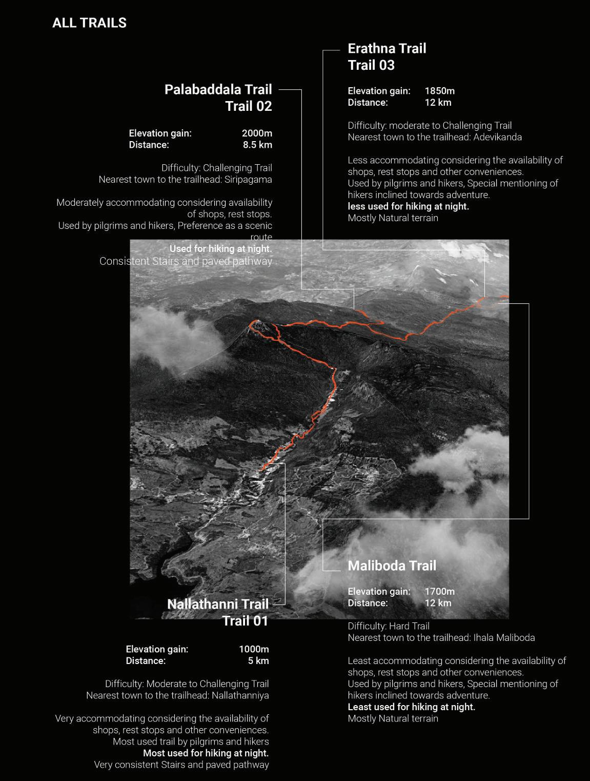
4.4 Trails of Sri Padaya
4.5 Anthropogenic light at night in Peak Wilderness Santuary
4.6 Analysis of all trails
4.7 Nallathanniya Trail Spatial Analysis
5.The Stakeholders
5.1 Human Presence
5.2 Persona Study 5.3 Ecology and biodiversity
6.Framework
6.1 Framework plan
6.2 Meta Analysis
6.3 Master plan of identified nodes
6.4 Time plan for Nallathanni trail
Throughout the History of Mankind, night sky full of stars has been a has been an experience mixed with a sense of wonder, awe and observations. Looking up to the night sky and feeling a connection to something greater. The vastness of the cosmos, mystery of the universe had inspired creativity, philosophy, sciences and spiritual beliefs. Observing night sky, and the experience had led to the exploration of astronomy, Astrology, spiritual and cultural interpretations of stars. (Melbin, 1978) Inspiring paintings of Vincent van Gogh (The Starry night - 1889) and many others through out history are some of the common references to explain the inspiring relationship between Humankind and the Dark sky. And this immense impact for inspiration through starry night sky can be also seen, regardless of the beliefs and cultures around the world. It is the awe, or the wonder that makes Dark skies a Human experience.
The increasing use of artificial light at night and the unmanaged nature of usage significantly has impacted the human experience of nighttime nature. It is also evident that the disruption of natural daily, seasonal, or lunar patterns have affected human sleep patterns and health. (Gaston, 2017) Artificial light altering natural regimes of the sky brightness will potentially lead towards vast ecological consequences.
(Davis, 2013) Furthermore, clear skies allow the migrating birds to orientate themselves in space and in time of the solar cycle.
(Barentine, 2022) Out of 140 bird species studies in north America, 47 are growing in population due to longer nights and artificial light extending the perceived photoperiod which allows better visibility for the birds.
(Knop, et al., 2021) These changes of night sky can have a significant impact due to disconnection from the natural world and loss of the dark sky experience. (Gaston K. 2018) These issues present implications for both anthropology and philosophy while raising the necessity to understand the natural world and our place with in it.
There are many organizations and communities that work towards regaining the dark skies and conserving the dark sky, such as Darksky International, Dark sky Society and other regional organizations. These organizations have been truly admirable over the years and the world could definitely use more of them to spread the message of mitigating light pollution.
Considering the global light pollution growth it is also essential to understand the significance of inspiring the developing world to not dive in to the same mistakes of developed countries that they are now trying to correct. Context based holistic approaches would allow us to understand the social cultural and ecological factors and contextual problem solving methods to better face the challenges with a more symbiotic sense.
"The greatest danger in times of turbulence is not the turbulence; it is to act with yesterday’s logic."
– Peter Drucker
‘What
if, there were Public, Accessible Dark Sky experiences.’
‘Would that inspire and create awareness of light pollution mitigation with in the Public.’
The change of perspective, moving from convenience prioritized mindset to a more sensitive holistic mind set requires deeper understanding. We as humans are an experiential species where we learn through our experiences and more real the experience more impactful it becomes, validating the understandings. It is through experiences we would see social change and not by just showering the public with information. And real change is possible through experiencing harmonious responsible lighting practices and how much that could affect the human experience of night time and also the ecological sustainability.
This thesis work is based upon these core beliefs; experiences would create public awareness and hence impact the social, ecological, cultural change.
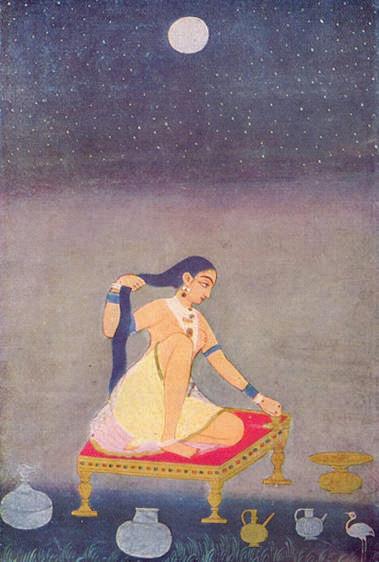
Fig: 01 Artist unknown, Radha at night, circa 1650 (Mughal), Kupferstichkabinett Berlin
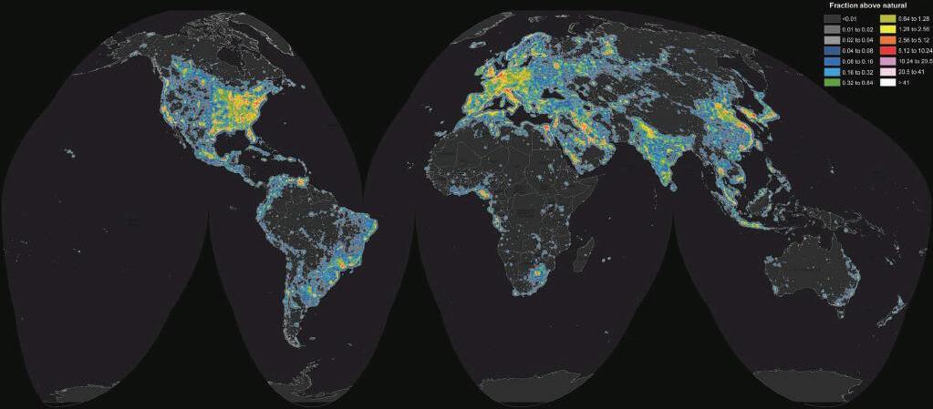
Fig: 02 Map of Global Light Pollution, Source:(Falchi, et al., 2016)
Human experience
Dark sky Light pollution
1.1.
and significance of the study
1.2.
Understanding The Dark sky and Nighttime Hiking
1.3. Why Siri
Padaya?
Problem statement
‘How to accommodate nighttime hiking in dark sky environments with responsible use of light?’ Objectives
The objective is to conduct a holistic study of the context, applying interdisciplinary approaches and combination of qualitative and quantitative methods. Through the in-depth understanding of lighting strategies for dark sky environments, presents comprehensive interventions for existing nighttime hiking environments and guidance for anyone with a light source out in nature at night. Also creating responsibly accessible environments for night time hikers, allowing the experiences in nature less harmful towards the natural ecosystems. Aim
The project attempts to explore methods of place making, using light. Creating an identity based around conscious use of light in nighttime. Hence create awareness and impacting society for betterment. The responsible innovation through lighting practices will allow functional resilient and sustainable outcomes. creating socio-cultural, economical, ecological benefits and eventually social behavioral change through awareness.
Dark Sky
According to the Analysis of global map of light pollution by Dr. Fabio Falchi and his team, (Falchi, et al., 2016) Europe and North America are now the overall brightest land masses on earth, where 99% of the night sky is affected by light pollution. Globally, 83% of the population lives under light polluted skies. it is also important to consider the less light polluted regions where it is predicted that radiance and extent of artificial light at night will increase by around 6%, annually. (Hölker, 2010)
Due to unmanaged projected light towards the sky, reflection and aerosol scattering of light; dark sky is lost. Hence creating numerous damages to health and ecological systems, as mentioned in the Introduction.
Nighttime Hiking
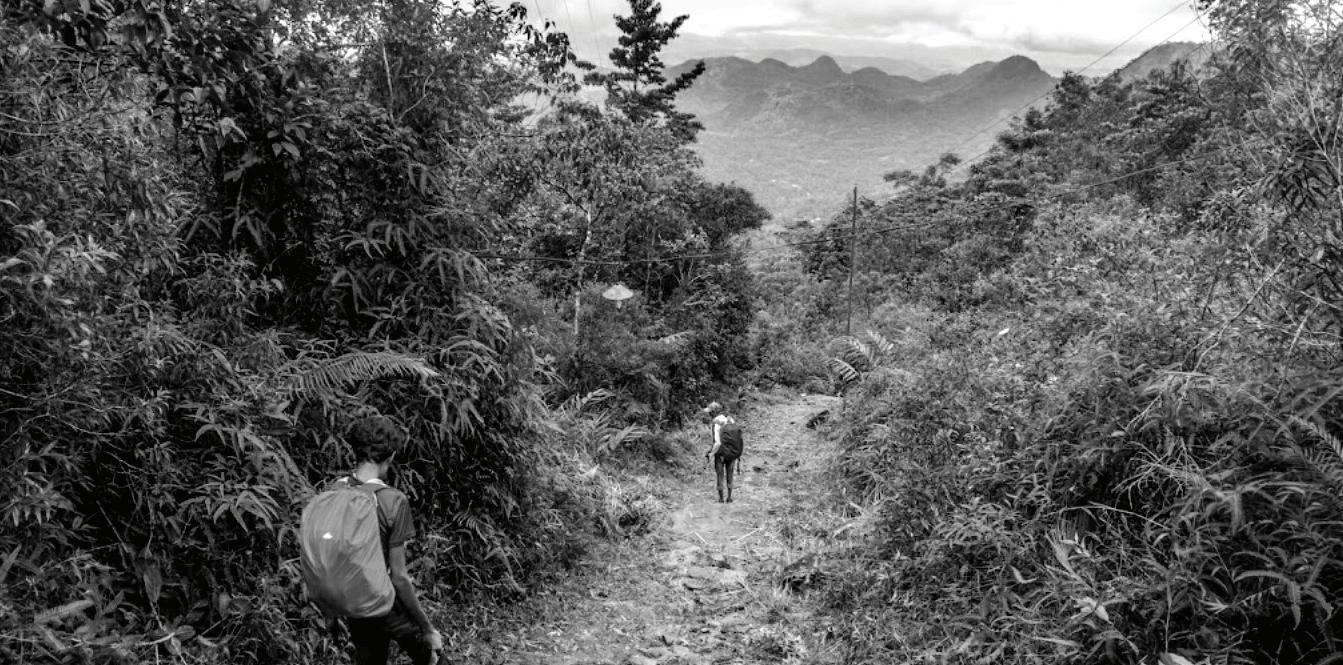
Nighttime hiking speaks of hiking during night time, and it is quite literally an opportunity to explore nature in a different light. The low light conditions and the environment allow us to adopt to an unusual experience through our sensors and perception. (Beeco J. 2009) And a fact of interest would also be the increased challenge, risk, and a sense of solitude. (Beeco A. 2012)
Hiking at night may vary mostly according to the purpose of the hike, such as educational, recreational. Furthermore, for stargazing, kayaking, astronomical research or astro photography, study of nocturnal animals, and so on. (Melbin, 1978)
Before coming in to Sri Padaya, step back in to active night time experiences of night time; to explore potential scenarios of experiential human activity at night time. There are several examples around the world that could be mentioned where people travel at night, on foot in a natural landscape. All these scenarios utilize artificial light and are done for a variety of reasons. Commonly these scenarios could be analyzed by factors such as How remote the site is, How tough the terrain is, Ecological significance, Cultural significance, Level of human activity.
Several well known examples of night time hiking are mentioned below.
1. Full Moon Hikes in National Parks, USA
2. Firefly Watching Tours in Southeast Asia
3.Aurora Borealis Tours in Northern Scandinavia
4.Stargazing Tours in Chile's Atacama Desert Mount Fuji, Japan (Yoshida Trail Night Ascent)
Among these examples. Most are highly exclusive or guided tours and most are in very much ecologically sensitive environments. Sri Padaya takes a significant place among the examples since they are spiritual journeys or pilgrimages and a wide range of demography is interested in the activity. It is also interesting to notice that Sri pada is the only place where the trails are illuminated for the public.
The Context of Sri pada/Adam’s peak is considered for this project since it is very much relevant, 4 main factors could highlight the rationale behind the decision.
- Dire necessity to mitigate light pollution in the peak wilderness sanctuary.
- Access to the public for 6 months a year, hence potential for impact and create awareness. And Potential to reshape an identity with Public Lighting
-Established human activity for centuries, potential to explore context based responsible lighting strategies
-Familiarity and relevance towards the researcher are also considered.
1.4. Methodology
Sustainability + Conservation are collective efforts in society and awareness is a significant root cause for achieving such goals. True collective efforts require change at societal level. Setting a president for creating experiences of conserved dark sky through responsible lighting practices; presents an opportunity for awareness.
Considering the extent of public engagement, sets the potential for impact societal change and hence towards collective efforts to sustainability and conservation. This is the ontological position of the study.
Considering the aims of the project; the Methodology is focused on answering the research problem (How to accommodate night time hiking in dark sky environments with responsible use of light?) through a pilot project. This means research is built around aspects of implementing responsible lighting strategies specific to the project in hand and all chosen research methods to literature studies focus on this purpose.
Theoretical phase
How to accommodate nighttime hiking in dark sky environments with responsible use of light?
How to understanding a context, holistically?
What are methods of creating functional identity/Place making ?
What is the relationship between vision and darkness?
What is Responsible lighting in darkness?
What is the story of Sri Padaya?
How can we map the dark Landscape of Sri Padaya?
What is the Human Association with light and the context?
How can we be sensitive towards the ecological significance?
Holistic Design Approach to Achieve Key Objectives
Responsible lighting practices, A Proposal
Through the theoretical phase of the research, concepts aligned with ‘Understanding a place for the purpose of creating empathy towards it’ was explored. Through understanding concepts such as holism and design with nature; allows us to experience the context in a grounded empathetic sense. The theoretical study of darkness and vision allows us to understand the margins of functional lighting and explore approaches towards experiencing darkness. This study also focus on the impact of artificial light towards ecological systems.
Responsible lighting in dark sky environments are also explored through theoretical approaches and considering several case studies as practical research. Building of the understanding of mitigating light pollution, the ecological impacts of artificial lights and possible mitigation methods were also studied.
Empirical phase
Through the identified concepts of understanding a place in the theoretical phase, Sri Padaya as a context is discussed. Spanning over historical, social cultural and ecological aspects. The context is analyzed through focusing on two trails identified as high potential for impact.
Analysis of the context through series of maps allow us to understand the context as a whole.
The initial survey visit explore the views and potentials along these targeted trails; through observations and photography. Human activity is better understood with interactions with the community based on a interview framework.
Through the initial survey. Nodes and hot-spots along the targeted trails are identified. Photographs and observations analyze the existing Artificial lighting and potential for improvement. A second survey of the selected nodes along the trails, focus on the human activity and social cultural aspects that would present requirements or boundaries of artificial light in the context are analyzed. Identifying zones of human activity and ecological behaviors in the context allows us to approach the issues holistically.
Through the analysis of context and stakeholders, frames design opportunities.
Design Proposal
Moving on to the design proposal, combination of several approaches to accommodate night time hiking in nature, with responsible lighting strategies; is proposed. The design proposal would include focus towards building a guideline of artificial light usage for the area. Identifying different trails with different sensitivities in an ecological sense and cultural or human activity; hence resulting in a series of lighting scenarios. Holistic approach allows interdisciplinary outcomes and overall process is then reflected upon, by the author.
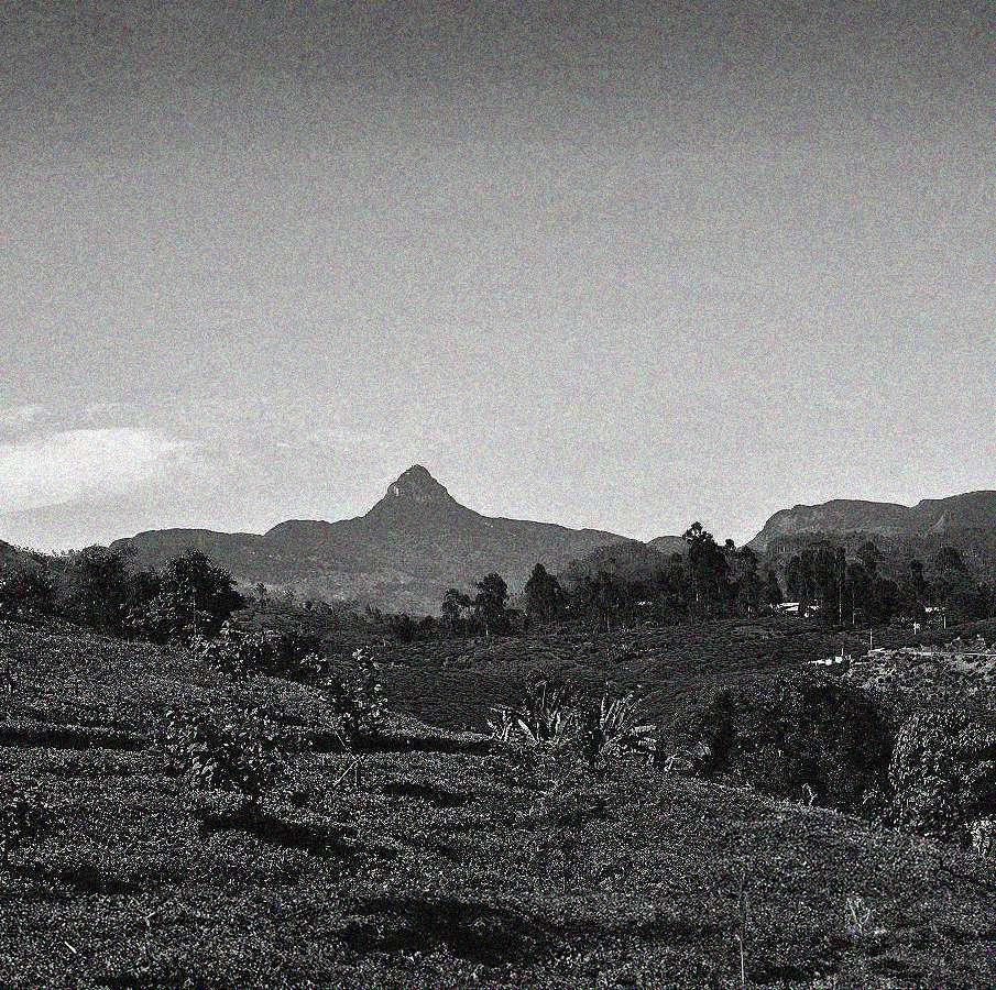
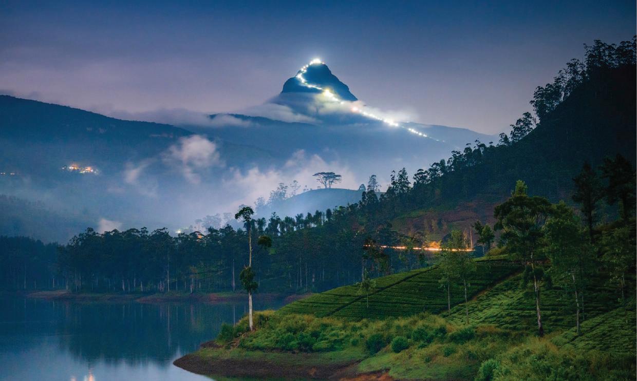
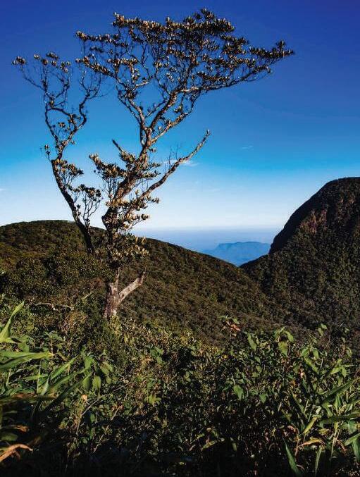
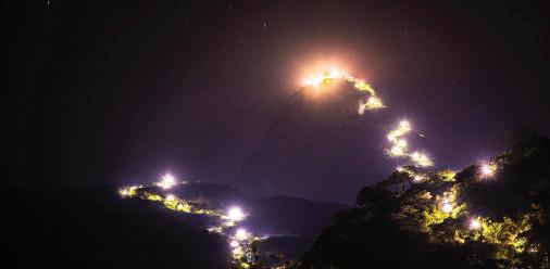
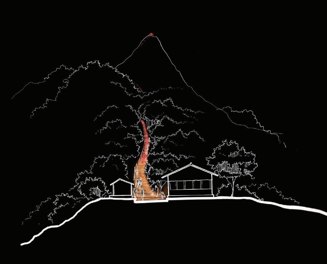
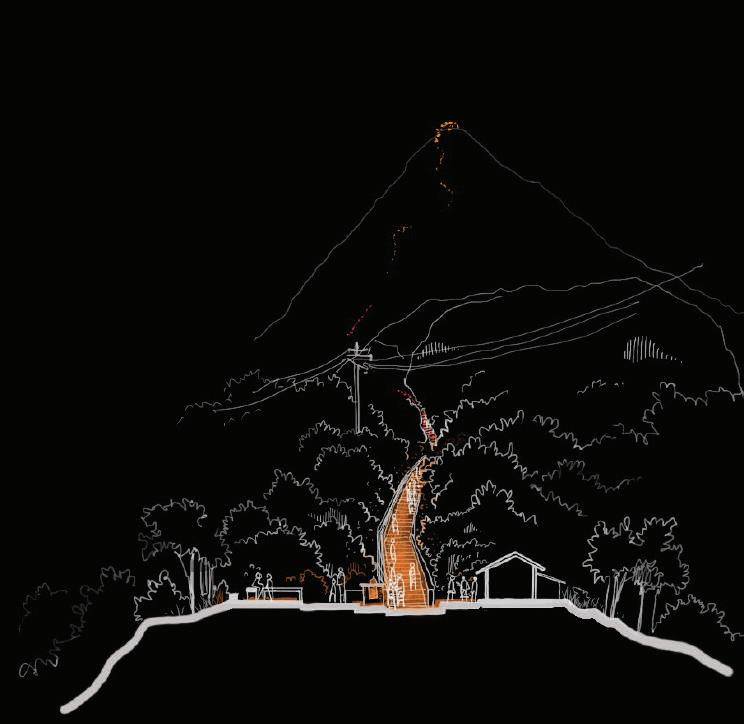
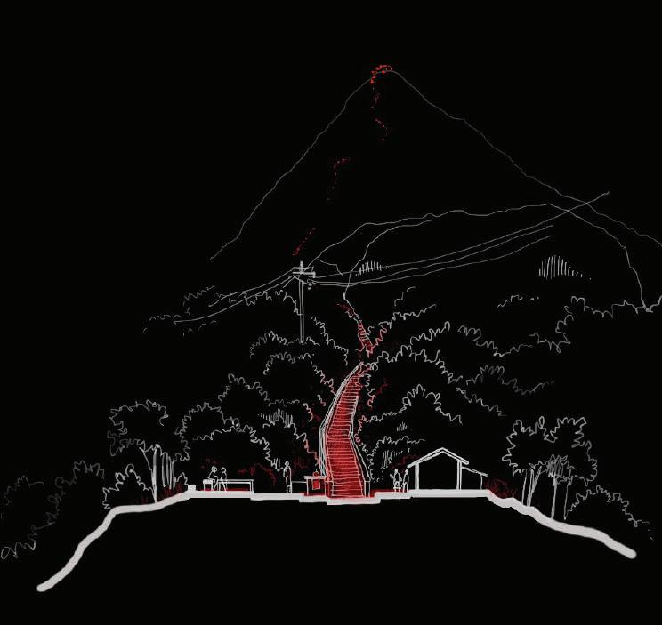
Fig: 03 View of Adam’s peak at night, from Maussakelle Reservoir_
Thilina Kaluthotage
1.5. Limitations
Considering night time hiking in nature, is a wide area where user personas and ecology vary widely and hence main limitation would be the project's focus towards a single context. Also within the context, site would limit to a certain range of the trails.
Throughout the project author has not accessed the site. But based on previous visits author relates to the context. for the purpose of analysis and studies, a survey team was coordinated by the author to gain photographs, gather information, conduct surveys.
Only the outdoor lighting elements along the trails, are considered. This includes public spaces in that the trail moves through. But any kind of lighting that would be available on buildings, or temporary structures are not considered. But a general guidline would be suggested.
The project focusses only on the trail which the hikers travel and would not consider the paths that are leading outwards the trail and elements such as street lighting up to the start of the trail.
The indicative nature to calculations- the lighting calculations for the lighting design is conducted only through computer aided design and lack of real life experiments and studies is a major limitation.
Time The project surveys and analysis is conducted in a small time frame and remote survey methods would be another limitation.
These limitations and identifying them promotes further research and development within the area of the study.
Outcome
A design proposal overview with a set of guidlines and suggestions, that are site specific. Implementing responsible lighting practices for a harmonious balance between light and darkness, whilst creating a more functional, considerate and site specific lighting design intervention. Through the design outcome, it sets a precedence for sustainable, responsible lighting practices in the context. Presents an opportunity for a comprehensive discussion.
The chapter is a section of the literature review focusing on how to create an understanding of the context for the purpose of design interventions. It is essential to understand the context not solely for the reason of making an intervention, but also to understand the contextual knowledge and the process of evolution over the years, that resulted the current context.
Holism
It is a crucial concept to grasp in order to understand the mass interactions between multiple segments of a system. Bringing solutions that last, that coexist and that supports purpose; as a whole. A holistic understanding of a context means to always view the issues at hand with various lenses though out the design process. These so-called lenses shall be defined and they allow us to analyze the different aspects of design. (Restrio & Braae, 2019)
Jan Smuts defines holism as the ‘tendency in nature to form wholes that are greater than the sum of the parts through creative evolution.’ (Smuts, 1926).How ever the abstract concept of Holism is a paradox where more than the sum of all parts would always be missing and hence the outcomes, not holistic.
“In many ways, the environmental crisis is a design crisis. It is a consequence of how things are made, buildings are constructed, and landscapes are used. Design manifests culture, and culture rests firmly on the foundation of what we believe to be true about the world.” (Van der Ryn & Cowan, 2007)
A question that arises is, Can culture manifest into design?
Genius Loci
Christian Norberg-Schulz (1920- 2000) brings the concept of genius Loci, back from the roman belief that every independent being has it’s genius, it’s own guardian spirit.He describes the Genius loci as the essence of a place, with genius loci he presents an antidote to the modernism and globalization which creates monoculturalization of places. (Norberg, 1976)
Essence includes the totality of all animals trees organisms and inanimate objects, light and even perceived emotions of a place, and the reasons of this totality to exist together would define the Genius. It is crutial to listen to the essence of a place. By reflecting on the roots of the place we can help ourself to understand ourselves and others and the place we inhabit and build a sense interconnectedness with the place and our co-inhabitants. (Norberg, 1976)
Place branding and place making
The presentation of a place as a brand, takes shape in three ways. The conceived or imagined, built or materialistic, and social or experienced. For rebranding of a place, it is possible to ‘clean up’ and change the image of the place, which is the monocultural approach and the other is to embrace the identity and building from within.
(Broudehoux Kavaratiz Giovanardi, & Lichrou, 2018)It is important to bring out the place as itself. To pretend and to brand for the prosperity with no grasp of concern for history, or belonging is potentially disastrous Jan Gehl presents the concept of place making. The ability to create function and experiences, promote social engagement and foster a sense of community. Although the concept is commonly discussed in the urban context. It is an interesting thought to notice the potential of places and to revitalize to create inclusivity. (Gehl, 2013)
Design with nature
Design with nature by Ian McHarg is a prominent work of literature that promotes the integration of ecological principles. It emphasizes the importance of natural characteristics of a site—such as geology, hydrology, vegetation, and wildlife—before planning any intervention. Highlights the potential of working with the nature, rather than against it. The interventions through a rigorous process of empathy and analysis of a place as a whole caters lasting, symbiotic results.
(McHarg, 1971)
The best intervention is harmony and balance.
Discussion
A place has to be understood at its roots. Understanding holistically and with focus on it’s genius Loci. Providing for the nature and creating harmony and balance for all participants that are involved is critical; no matter human, animal inanimate or imaginary participants might be. Is place branding, the way to create inclusivity, and belonging of the context to the users? How could functional interventions create potential for conservation while enhancing materialistic, social or spiritual needs of a place
The chapter is the second half of the theoretical study. Building the background for the lighting concepts that would be later explored in the design proposal.
Understanding the human vision and boundaries of vision for animal life. Impact towards plants, Significance of darkness and adoptability of vision for darkness. The Light pollution mitigation methods were also studied to structure widely accepted responsible lighting practices. Conservative and sustainable approaches relating to lighting technology and towards practical concerns of implementation are considered. A practical research was conducted through studying several case studies of award winning responsible lighting design projects focused around dark sky conservation and concern for wild life.
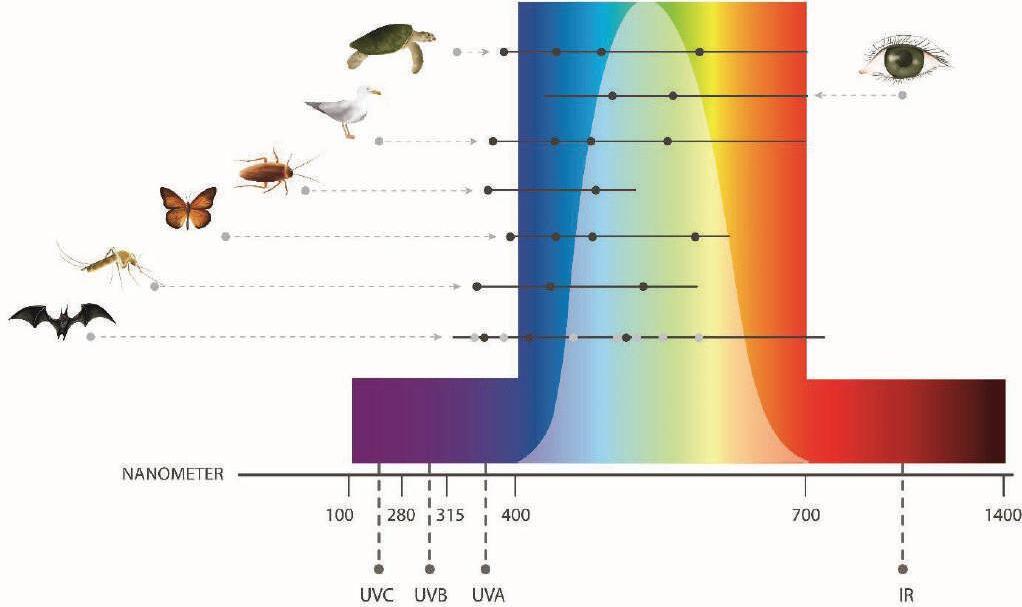
3.1. Light and Vision
3.1.1. Light
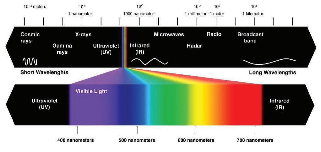
Electromagnetic radiation which is visible to the human eye is regarded as Light. Various properties of light, such as intensity, color, distribution and direction, could be used to describe light. Intensity refers to the amount of light energy, higher the Energy, higher Brightness of light.
Colors could be defined through ranges of wavelengths found within the visible electromagnetic range. And, direction and distribution depends on the nature of the light source. (Dilaura, 2011)
The figure below visualizes the position of visual spectrum on a larger range of electromagnetic radiations and range of wavelengths for colors.
05
Source:(Department of Climate Change,Energy,the Environment and Water, 2023)
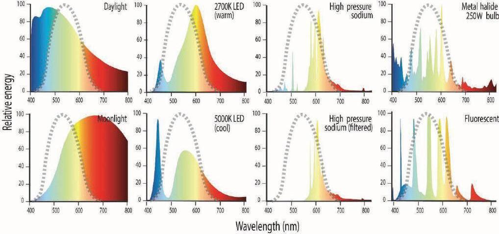
Every light source could be characterized using the ranges of electromagnetic wavelengths emitted. This range when visualized is called the spectral power distribution curve. Considering random two light sources which, with the human eye, might seem to be the same color; could have completely different spectral power distributions. Therefore, attention towards spectral power distribution is crucial. (Department of Climate Change,Energy,the Environment and Water, 2023)
3.1.2. Vision
Human vision
Human vision range from 380nm (shorter wavelength or Violet) and 780nm (long wavelength or Red). Perception of visual range is subjective and identification of color depends on how human eye interprets light. (Keith, Elvidge, Tuttle, & Baugh, 2010)
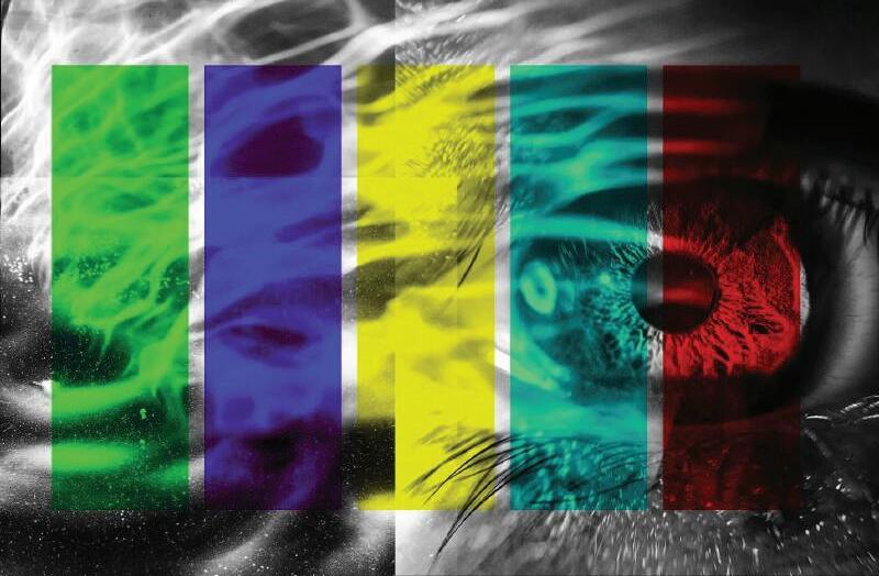
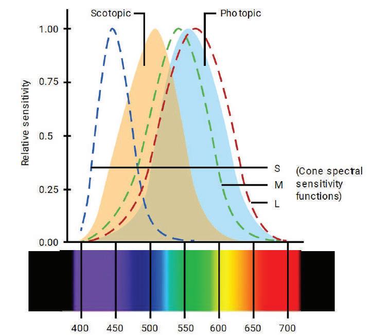
Photopic, Scotopic and Mesopic vision
The human eye utilizes four types of photoreceptors: rods and three kinds of cones (L, M, and S cones). Depending on the light levels (specifically, the luminance input), the brain processes stimulations from these photoreceptors to perceive brightness. Scotopic vision uses rods, and the light level should stay below 0.001cd/m2 to activate purely scotopic vision. the perceived image through rods would be monochromatic. Any brighter light would disturb scotopic vision and it would take close to another 30 minutes for the rods to adopt again to low light situation.At light levels brighter than 2cd/m2, photopic vision is activated using cone receptors
Fig:
Fig: 06
Color and apparent brightness could be determined with photopic vision. There is also mesopic vision which uses both types of receptors. Mesopic vision is associated with input luminance between 0.001cd/m2 and 3cd/m2. (Paschotta, n.d.) (IESNA Outdoor Environment Lighting Committee) (Cao, 2013)
Among 4.5% of the polulation, Abnormal color vision that is either inherited or acquired is to be expected. These defects of color vision mostly do not change over a lifespan and are not a result from other visual problems. (Cao, 2013)
Luminosity functions; represent the human eye's spectral sensitivity. The Commission Internationale de l'Éclairage (CIE) has published official versions based on the average visual perception of individuals with healthy eyes under specific experimental conditions (for the CIE standard observer). (Paschotta, n.d.)
Vision
Another important remark is the visual system of specific animals. Each visual system of each organism is different and unique. Therefore, resulting different perception of light based on light intensity and color. some animals extend their visual sensitivity beyond the visual range of humans, such as visibility of ultraviolet light for Bees. Understanding subjective experiences of light from different animals allow better understanding of animal behaviors, ecological interactions, and therefore impact of ALAN towards the Ecosystem. (Dilaura, 2011) (Commonwealth of Australia, 2020)
3.1.3. Night time
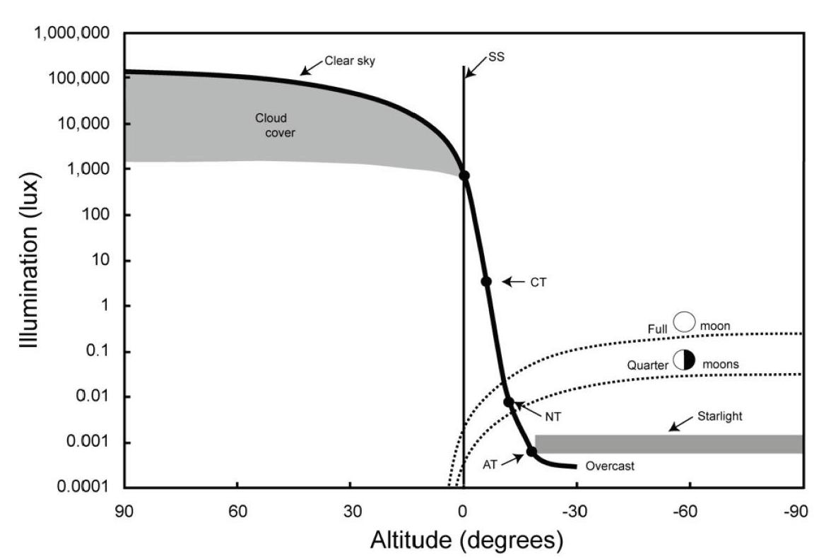
Nighttime nature without any human disruptions is a luxury in the present world. To understand the impact of light pollution and mismanaged lighting on nature, it is important to know the natural light levels of nighttime and understand the significance of these low light levels at night.
According to the figure, it could be easily observed the natural presence of light depending on different scenarios. Once the sun angle is well below the horizon (-15°), late twilight hours, natural light range roughly around 3lux. From there on it’s a decline and moon or stars would be the natural sources of light, beyond this point. The maximum light level that could be observed would be around 0.1lux, with a full moon. Starry sky alone would result one hundredth of the full moon illumination(0.001lux). (Barentine, 2022)
3.2. Light Pollution
Light pollution is mainly an issue of mismanagement and lack of attention to planning. Following could be identified as main causes of Light pollution. (Dilaura, 2011)
Glare - Caused by excessive and uncontrolled brightness visible to the user, which can be uncomfortable, reduced visibility and even hazardous in certain situations.
Skyglow – Brightening of the night sky due to artificial lighting is known as sky glow. Caused by spill light and reflected light towards the sky. Due to molecular or aerosol scattering of light bounces back and forth creating a glow effect. Air pollution or high humidity or mist could also amplify this effect. (Tidau, et al., 2021)
Light trespass unwanted or unintended illumination of a certain area could be identified as light trespass. Poorly designed and planned lighting will cause this issue.
Clutter – excess of light sources that creates a disorienting and confusing visual environment. It contributes to overall brightness of the night sky and negatively impact both Human health and Wildlife
Over Illumination – excessive use of light. When the parameters of precise amount of illumination related to a certain task is overlooked, the resulting environment would have excessive illumination, which in an outdoor environment would massively impact light pollution. And, a wastage of power.)
3.2.1. Impacts of ALAN and Light Pollution
Impact on Humans
Skyglow can create interference with astronomical observations. And they could disrupt the circadian rhythms. Light pollution is also could be identified as a measure of efficiency, meaning the higher the light pollution, lower the efficiency of power usage for lighting. (Standards Australia Limited, 2019) (Falcon, et al., 2020)
Most of all as discussed in the introduction, light pollution impacts the disappearance of starry sky and obstruct the human experience of the universe.
Impact on wildlife
Glare and skyglow will disrupt migration patterns of migrating for birds, interference with hunting and foraging, confusion with moon light could result massive disruptions in breeding cycles and behaviors of nocturnal animals. (Knop, et al., 2021)
According to behavioral studies of nocturnal animals based around changes of natural light levels at night (moonlight, light from the starry sky, overcast nights); it is observed, even slight changes of light levels (0.0001 –0.001lux) effecting animal behavior (in this case – owl monkeys of central America). Around 0.001lux nocturnal bees and fruit bats show increased/decreased foraging. (Aulsebrook, et al., 2022)
Impact on plants
Depending on the natural light-dark cycles, for proper growth, development and ecological interactions. Anthropogenic Light at night impacts these processes in plants. This leads to altered growth patterns, affecting the plants' fitness, timing of biological events, such as bud burst, leaf senescence, and fruit ripening, and causing mismatches with other organisms in the ecosystem. These changes in turn impact the whole ecosystem. (Meng, et al., 2022) (Bennie, Davies, Cruse, & Gaston, 2016)
3.3. Mitigating Light Pollution and ecological impact of Anthropogenic light at night
Light pollution mitigation at large is a matter of well-organized regulations in the use of artificial light. Over the past century of intense utilization of electric lighting, growth of light pollution, research and understanding of light pollution; various countries have adopted different rules and regulations to address the issue. These regulations vary from country to country and the forefront of battling light pollution is lead by organizations which value conservation of dark skies.
The International Dark-Sky Association (IDA), based in U.S.A, The Campaign for Dark Skies (CfDS), affiliated with the British Astronomical Association (based, United Kingdom), The Royal Astronomical Society of Canada (RASC), The German Lighting Technology Society (LiTG), The Australian Dark Sky Alliance (ADSA); are some of the organizations which drive the discussion of mitigating light pollution. Local authorities in certain countries also have tremendous attention towards mitigation of light pollution and creating a sustainable nocturnal environment. It is also important to highlight that developed nations tend to high awareness and concern regarding light pollution and light pollution mitigation, compared to less developed nations. For the purpose of this project, the methods of light pollution mitigation and minimizing ecological impact are strictly focused on lighting guidelines and suggestions that relate to lighting in nature parks and similar situations. Also, with strict focus towards most minimally disruptive practices, when it comes to public spaces.
The following are best practices defined by above mentioned organizations and local authorities from various countries.
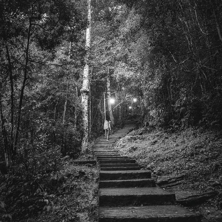
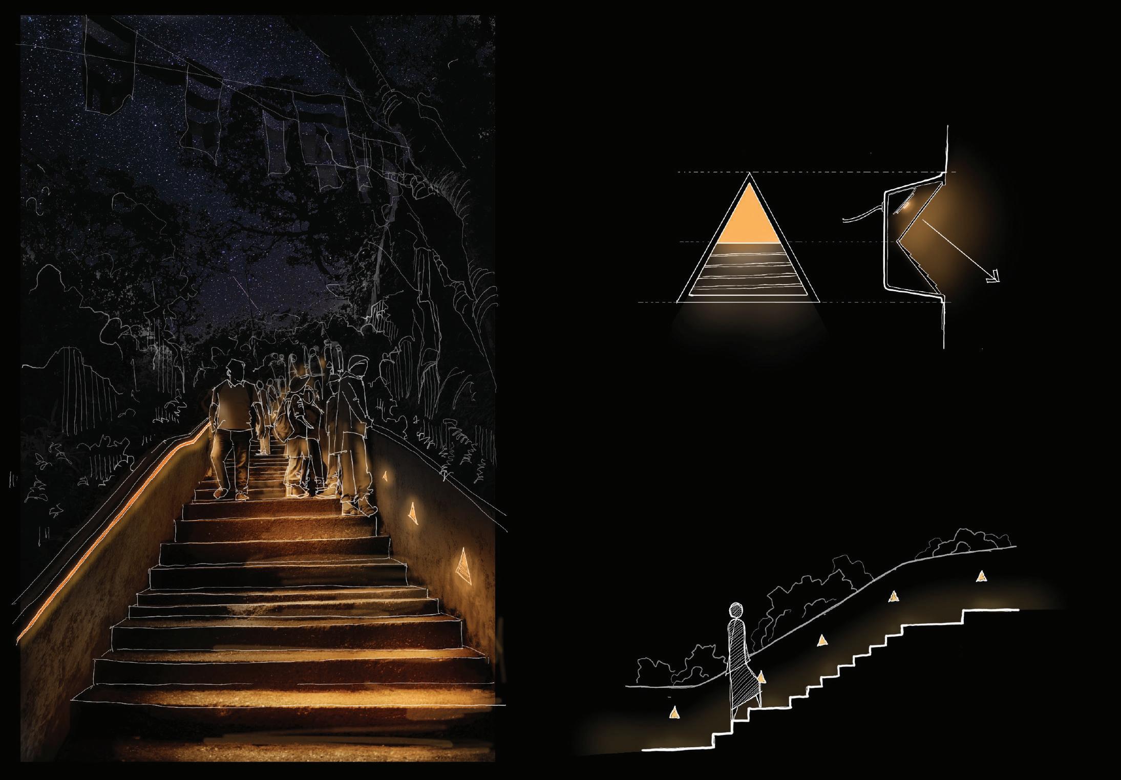
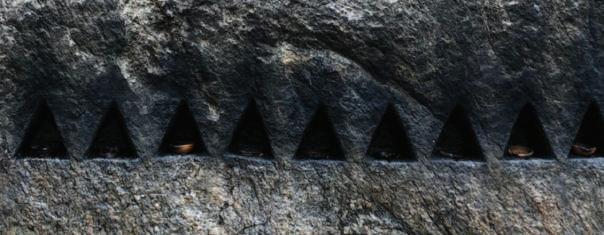
3.3.1. Being familiar with darkness
Considering the context of this project, the best lighting strategy would be no light at all. Therefore, it is important to entertain the idea of using no lights as much as possible. Lighting, even when used; shall try to allow scotopic vision stability in darkness and situations of compromising night vision shall be avoided.
To have an idea about natural light levels, following illumination levels could be referred –Full moon (max – 0.26lux / typical – 0.1lux), twilight (0.1lux), overcast urban sky with light pollution (0.15lux). furthermore, people have reported, seeing “fine” at full moon illumination levels and with no glare situations. (Dick, 2016)
3.3.2. Use Light only where it is needed
Focusing light only on the expected area is vital. Positioning the light sources as close as possible to the ground, while being functional, and using shields or covers could also be used to manage and to make sure light is directed only towards the intended area. Light spill from the user’s perspective is glary, and spill light above horizontal plane of the light source directly impact the sky glow. Therefore, avoiding any spill light or unintentional lighting, is crucial for light pollution mitigation.
(Department of Climate Change,Energy,the Environment and Water, 2023)Even though it could be argued that unshielded lights could illuminate a large area, The illumination level at more that twice the mounting height from nadir is less than 0.1% or the illumination at nadir. (Dick, 2016)
According to the Illuminating Engineering Society of North America (IES), types of shielding is defined with the horizontal plane across the light source, known as “cutoff”. Semi cutoff partially block light directed above the horizon, cutoff is at the horizontal level and more focused blocking is full cutoff. (Department of Climate Change,Energy,the Environment and Water, 2023) (Dick, 2016)
The IESNA (Illuminating Engineering Society of North America)suggests BUG system, which defines illumination from a luminaire more specifically. (BUG – Back light, Up light, Glare) Identified ten zones define the impact of using a shield and glare from a specific light fixture. This allows an effective assessment, when selecting a luminaire for outdoor nature environments. (Take 3 Lighting, n.d.)
3.3.3. Use of Adaptative Controls
LED Technology and innovations in networking and sensors allow us to use various adoptive controls. Mainly based around presence and time of the day or year. Strategies such as dimming capabilities, motion sensors, occupancy sensors, timers, astronomical clocks, remote monitoring, spectral changes and individual control options could be employed to optimize lighting to efficient, functional requirements of different situations. They are also effective in reducing energy waste and preserving the natural darkness of the night sky. (Department of Climate Change,Energy,the Environment and Water, 2023)
Commonly there are four reasons behind outdoor lighting; Navigation – to assist in wayfinding, Aesthetics – as a visual cultural display, Safety – It renders Hazards more visible, Security – assist security personnel. Best practices and standards in the urban environment are largely driven by the security and safety aspects in most cases. (Dick, 2016)
In all cases lighting situation shall be a rational combination of four common reasons mentioned above. Understanding the reasons behind the use of lighting and very precisely minimum light levels shall be maintained in nature considering the repercussions of unmanaged anthropogenic light at night. Not only focusing on the energy consumption of the light source, but the luminance of the luminaire and the reflectance of the surfaces shall be considered.Materials such as white sand or white painted infrastructure have the potential to reflect light and contribute towards skyglow. Also, darker surfaces or materials would require more light for them to be visible. Another factor to consider is the mounting height of the luminaires, since depending on the distance to the illuminated surface, perceived lighting situation would vary widely. (Dick, 2016) (Department of Climate Change,Energy,the Environment and Water, 2023) (IESNA Outdoor Environment Lighting Committee)
Materials such as white sand, limestone, or white rocks has the potential to be used as a reflective marker for boundary, or along pathways; which will allow high visibility on moon lit nights and hence the ability to lessen the presence of anthropogenic light. (Dick, Canadian Guidelines for Outdoor Lighting(Low-Impact Lighting) for RASC Dark-Sky Protection Programs, 2020)
Considering these factors, it is vital to conduct experiments on site, with user interactions and in different conditions; to determine the exact illumination that shall be the minimum value for functional purposes and maximum possible value to have, without contributing towards light pollution or ecological disturbances.After studying various illumination guides for outdoor environment, from different authorities and organizations; for the purpose of this study, “Canadian Guidelines for Outdoor Lighting (Low-Impact Lighting)” by the Royal Astronomical society of Canada, was adopted as a framework for understanding the illumination levels. There are several dark sky protection programs which utilize these guidelines actively (Dark sky Preservers, Nocturnal preserve, Urban star park). Also, the regularly updated guidelines provide a more comprehensive idea about the exact illumination levels and conditions that should be achieved. The illumination guidelines tables are mentioned in “Appendix C” as an adaptation of guides from the said document. (Dick, Canadian Guidelines for Outdoor Lighting(Low-Impact Lighting) for RASC Dark-Sky Protection Programs, 2020)
3.3.5. Choose Proper Light Color
The color of the light is a crucial specification when defining the light, and in analyzing the impact and effects of a specific light source. As mentioned before different color light carry different energy levels and Blue light carries the most and travels the furthest. Particularly the 400-490nm wavelength blue light can be very damaging towards eye sight and would impact photoreceptors of the eyes in humans and in animals. (Tosini, Ferguson, & Tsubota, 2016)
Furthermore, Blue light largely impact the melatonin levels and hence impact the circadian rhythms of almost all animals.
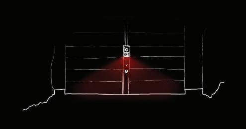
Considering that in this case, working on a natural context with extreme sensitivity towards wildlife, and dark sky; it is clearly evident that blue light, white light or any light with a high blue level on spectral power distribution diagrams. Compared to blue light, red light or light with wide wavelengths has less energy and has less potential for aerosol scattering, resulting sky glow. (Tidau, et al., 2021)
Light chromaticity allows vision system of different animals to view same environment differently. Taking advantage of this aspect; to some extent, it is possible to create a scenario where humans are capable of viewing the surroundings comfortably, while minimizing impact towards the wildlife.
According to the above diagram of scotopic and photopic luminosity functions in humans along with visual range of the electromagnetic spectrum; it could be observed that scotopic vision is not compromised by the redlight, since rod cells are less sensitive towards red light. And yet, red light allows better detail and visibility using L cone cells. This means no adaptation time for the user between different vision systems and allows the user to comfortably view the surrounding (since eyes are dark adopted). In the context of nature, this allows a comfortable presence with broader awareness of the surrounding. (Cao, 2013) (Department of Climate Change,Energy,the Environment and Water, 2023).
Considering the visual spectrum, amber is also a possibility for a non-compromising chromaticity, and yet it slightly overlaps with the scotopic luminosity function curve.The best option therefore would be the use of red light in the context of nature as a measure of preserving human night vision. and low impact on the wildlife. (Cao, 2013).
3.3.6. Raising Awareness and Public Initiatives
Light pollution unlike most pollutions, is simpler to fix. Simply switching off the lights itself would mitigate the light pollution. Therefore, considering the scope, involvement of large communities are needed to create considerable, real goals. It is awareness that would cater communities towards a cause. (Dark Sky Association, n.d.)
Public initiatives are the first steps towards crating public awareness. making sure to involve the public with in the planning process also would allow better understanding for the general public. Organizations such as International Dark Sky Association, conduct various campaigns to contribute towards exposing the concepts to responsible lighting to the general public.
3.4. Case Studies
Considering the unique aspects of the focused context of Sri Padaya trails (such as, highly active public presence in a wildlife sanctuary at night), there are not many case studies which would directly relate to the conditions and requirements of the context. However, among multiple projects that were studied, several are presented based on key takeaways.
An outdoor activity center in Wales visited by thousands of visitors annually, is transformed by responsible lighting practices. The project focuses on enhancing the night-time experience while cutting energy and the impact on wildlife. (Location: Plas Y Brenin, Wales, Lighting Design: Dark Source)
The project uses red light to minimize impact towards the local foraging bat population. It also provides the required light levels and uniformity according to road and cycle path standards in Denmark. (Location Frederiksborgvej, Denmark, Lighting Design Light Bureau)
The waterfront promenade is been designed with attention to the adjacent eco systems. Use of less impactful spectral power, and innovative use of lighting controls, using sensors for tracking moving cyclists and adjusting the light intensity accordingly. (Location: Fürth, Germany, Lighting Design: Selux GmbH)
Case studies presented here relates to the project at hand in several details. Mainly, light controls and lighting arrangement for the purpose of accommodating movement through landscape. Understanding practical limitations, possibilities and potential for innovation.)
Fig: 08 Adopted by author, from existing research (Cao, 2013)
Fig: 09 Plas Y Brenin, Wales source: (Build Back Better Awards, 2024)
Fig: 11 Bat superhighway, Denmark source: (Selux, 2024))
Fig: 10 Bat superhighway, Denmark source: (Light Bureau, 2024)
Origin Story
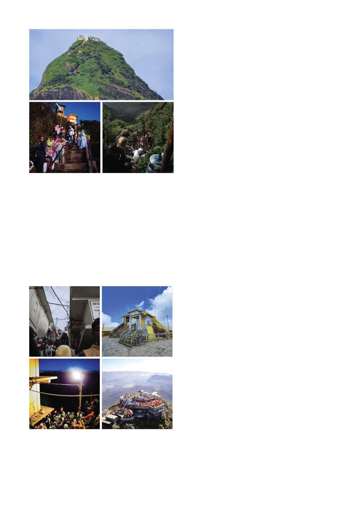
Sri Padaya or Adam's Peak (2,243m ASL) is a sacred mountain in central Sri Lanka, with a dominant form overlooking a large part of the island. At the summit, it holds a 1.8-meter rock formation resembling a human foot (“Sri Pada” – Holy foot), which is believed to be a emprint of Lord Buddha’s foot during a visit to Sri Lanka by the invitation of God Sumana Saman in the 6th century B.C. (Capper, 2022) However, there are also many believes for the significance of the mountain summit. The Christians believe it marks the first step of Adam after being exiled from Eden. Some Christians attribute the footprint to St. Thomas, Hindus believe it belongs to Lord Shiva, and Muslims believe it belongs to Al-Rohun or Adam. (Still, 2010)
History
The ancient chronicle from Mahawamsa mentions Sri Padaya with the visit of Lord Buddha. And King Valagamba fleeing to the mountain to protect himself from Indian invasions. King Vijayabahu I (Vijayabahu the great 1055-1110 CE) built resting pavilions and dedicated a village to provide for the pilgrims, according to a stone inscription found in Gilimale village. King Nissankamalla(1187 CE), Kind Parakramabahu II(1225 CE)are few other kings that provided for the pilgrims. (Paranavitana, 1958) (Raikar, 2023)
Italian trader Marco Polo mentioned Adam's Peak as a significant pilgrimage site. (Yule & Cordier, 1903) Arab adventurer Ibn Battuta named the mountain Sarandīb in 1344 CE, describing an iron staircase and chain-hung stanchions for pilgrims. (Dunn, 2012).Chinese voyager Ma Huan in the 14th century visited Adam's Peak, and it was said to be rich in rubies and other precious stones. In the 19th century, Europeans began climbing and writing about their experiences. (Davy, 1818)
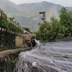
The peak wilderness sanctuary is found in the center of the western ridge of the central highlands, in Sri Lanka. Shares the boundary between Central and Sabaragamuwa provinces.Sri Lanka declared Sri Padaya as a Sanctuary in the year 1940 under the Fauna and Flora Protection Ordinance .Later declared as a UNESCO Natural World Heritage Site. (UNESCO World Heritage Center, 2017)
The terrain surrounding Adam's Peak is notably rugged, rising from 50 meters above sea level in Rathnapura to 2,238 meters at the peak. It is also a very important Watershed for the island’s 3 major river systems, namely; Kelani Ganga, Kalu Ganga and Walawe Ganga. (Biodiversity Secretariat, Ministry of Mahaweli Development and Environment, 2019)
Peak wilderness sanctuary is considered as a "super biodiversity hotspot" inside the Western Ghats and Sri Lanka biodiversity hotspot. The sanctuary is one of the rare places on Earth with continuous natural forest cover, encompassing forest types from lowland dipterocarp to montane cloud forest. (Department of Wildlife Conservation Ministry of Environment and Natural Resources, Sri Lanka, 2007)
Wikramasinghe, Fernando, & Ranawana, 2019) Fig:
(Camille, 2022)
Nuwara
Daraniyagala
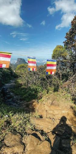
4.4. Butterflies, Guardian spirit and Pilgrimage
The Sri Padaya mountain is also named Samanala Kanda (Butterfly Mountain). It is believed that the name "Samanala Kanda" (Butterfly Mountain) originates from the diverse butterfly species visible during the Sri Pada pilgrimage season. Many people believe that these butterflies gather to pay homage to Lord Buddha's footprint. Even though this migration pattern of butterflies towards the Peak wilderness sanctuary from all over the island is widely observed, a (Ministry of Wildlife and Forest Resources Conservation, n.d.)
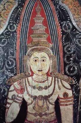
One of the most important guardian deities of Sri Lanka is Mahasumana. Also known as Sumana or Saman. He is the guardian or presiding deity of Sri Pada mountain, also called Samanthakuta (Adam's Peak).He is a deity, subject to local and indigenous belief and worship in Sri Lanka. The name Saman means "the rising morning sun". His main shrine is at Ratnapura, where an annual festival is held in his honor.at the beginning of the pilgrimage season, the statue of god Saman is being brought in procession from Maha Saman Devale to Sri Pada.
(Paranavitana, 1958)
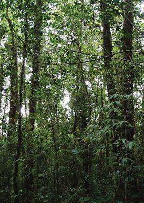
Lowland Rain Forest
(5,720.9 ha, 24% of total area)
Covers most of the south and southwest of the sanctuary. It could be characterized by a high diversity of tall (45m or above), dense, evergreen flora. Canopy, sub-canopy and understory layers could be observed.
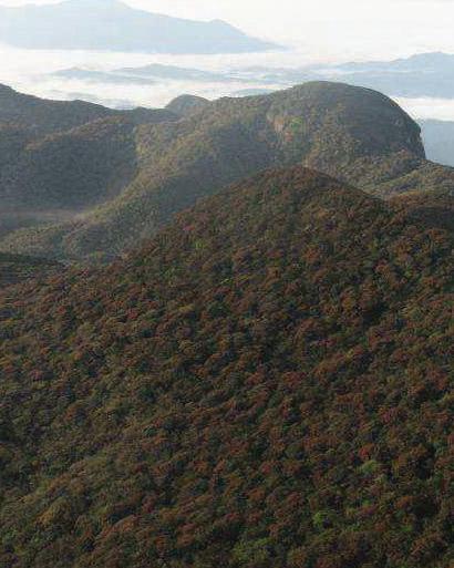
While it is much similar in appearance to the lowland Rain forest, it is shorter in stature due to greater impact from wind and lower temperatures. The moist and humid microclimates support an array of flora and fauna which dominates the sanctuary area.
The forest is at 1500m above sea level, and has an unusual composition of flora compared to the Indo-Malaysian region. The trees could be seen stunted with an umbrella shaped canopy, and the undergrowth is rich with orchids, mosses, and filmy ferns.
It's a specific type of montane forest with unique climate and ecological conditions. Humidity of the forest often exceeds 80% due to frequent cloud cover at canopy level. Many plant species in this forest are endemic. High diversity of mosses and epiphytes can be seen. (Lockwood, n.d.)
Endamic Species in the Context
Due to the island's unique and isolated environment, the sanctuary harbors a highly diverse and predominantly endemic population of flora and fauna. It contains a significant proportion of the country's endemic species, including 86% of amphibians, 41% of reptiles and eight mammal species are endemic, 39% of 491 species of woody plants are endemic. (Singhakumara, Cohen, & Ashton, 1995) (Hence, 2013) (Ministry of Wildlife and Forest Resources Conservation, n.d.)
Pilgrimage
Symbolic relation and social practices
Many practices and customs of the pilgrimage are enriched by local perceptions.
Though the Samanala Adaviya, the mountain is regarded to be guarded by the god Sumana Saman, for the traditional local people; the mountain itself is seen as a “living excellency”.
(Wickramasinghe, 2006)
“For the local people it resembles the head of their territory, its autonomous rights, purity, generosity, superiority, power and also its own governance, which qualities are determined by nature, invisible powers and linkages. The symbolic relations are enriched by the local understanding of the ecological function of the mountain forest and the linkages that are extended to the surrounding lowland terrain.
The traditional people see it as a living organism with superior and commanding powers” (Wickramasinghe, 2006)
“the socially accepted value system and perceptions about nature and the natural system define the role of humans and their responsibility to live in harmony.”
(Wickramasinghe, 2006)
From author’s own experiences about the traditions and folklore, the rivers that descend from the mountain area, thousands of flora and fauna, most of them being medicinal all most all being useful for the communities that surround the area; supports the perception of the mountain as an excellency which provides for his dependents. These symbolic meanings have enriched the relationship between local understanding of ecological significance, and folklore; along with fear and gratitude towards an “excellency” with commanding powers lay groundwork for conservation of the context.
The conical shape of the mountain itself is commanding and it is often regarded a scene of beauty and also as a symbol of superiority. On a clear day it is even seen from the coast of Colombo and the shape is clearly unique and upon seeing the mountain, a traditional local would hold their hand high and hail “Saadhu” (goodness) towards the mountain.
Following folklore relating to the sanctuary and pilgrimage are explained with the personal experiences and folklore that has been passed down through generations.
Trespassing – permission must be requested from the deities, before entering the sacred region either for pilgrimage or to gather forest resources. Over exploitation, wasteful extraction is regarded as actions which cause devastation in the short term. Such as injuries, loss of goods, not finding a way out or devil’s eyes (being processed by demons), and in some cases, even death. Similar consequences are said to be expected along the trails of pilgrimage; if a person deviates from the trail or disrupts the harmony of the environment, peace of other pilgrims or even themselves.
As explained, the pilgrimage is a journey of discipline, and also of empathy. It is often seen with the pilgrims who help each other, even strangers, sharing and caring. Every one greats any one who they meet with “Karunawai” (peace). Also no one asks anyone “how far is it to the top?”.
Folklores related to Sri Padaya and the pilgrimage Pilgrims' strict tradition has been passed down through generations. Respect for purity is expressed by disciplinary norms, which require pilgrims to bathe in the holy water running along the Seetha-Gangula stream, wear clean clothing, chant Thunsarana (Lord Buddha's meritorious teaching) and refrain from eating flesh. The long-standing relationship and practice of worshiping nature as a deity, as well as its superiority over human potential, enriches this cultural and ecological monument. (Wickramasinghe, 2006)
It is a journey of equality. Everyone travels on foot, and everyone takes the same path. Legends and belief make it possible for all ethnic groups to gather for a common interest; to safeguard and revere the sacred footprint, nature, and balance in a collective and harmonious way.
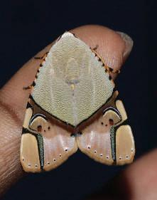
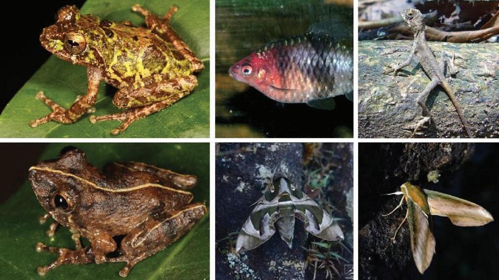
Fig 19: From Top Left; Pseudophilautus sirilwijesundarai. Source: L.J. Mendis Wickramasinghe, Top Middle Black ruby barb (Puntius nigrofasciatus) (Source: Derek Ramsey), top right: Sri Lankan Kangaroo lizard (Otocryptis wiegmanni) (Source: Nayantusita), Bottom left; Pseudophilautus bambaradeniyai. Photo by: L.J. Mendis Wickramasinghe, Bottom middle and right; Mosaic of moths on the summit of Sri Pada (source: (Lockwood, Archive for the ‘Sri Pada (Adam’s Peak)’ Category, 2020)
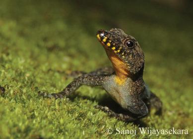
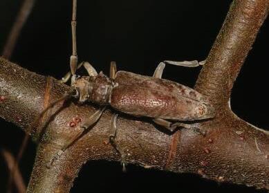
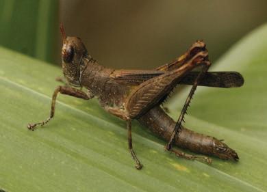
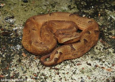
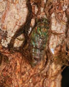
Fig 18: From Top Left; Cnemaspis anslemi, (Source: Sanoj Wijayasekara, amilasumanapala.weebly.com/blog), Top Middle Family Chorotypidae, not 100% identified (Source: Amila Sumanapala, iNaturalist), top right: Ramadasa pavo (Source: Nuwan, iNaturalist), Bottom left; Genus Acalolepta. (Source: Amila Sumanapala, iNaturalist), Bottom middle: Gloyd's Hump-nosed Viper (Source: Sanjaya Kanishka, iNaturalist) Bottom right; Pomponia polei (source: Shaveen Madushka, iNaturalist)
Fig: 20 Saman Deviyo (God Sumana Saman),the Gurdian Spirit
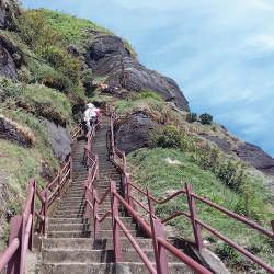
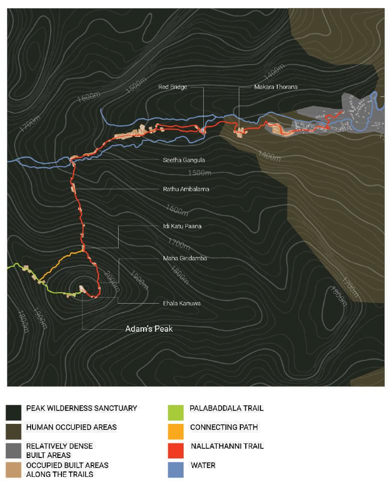
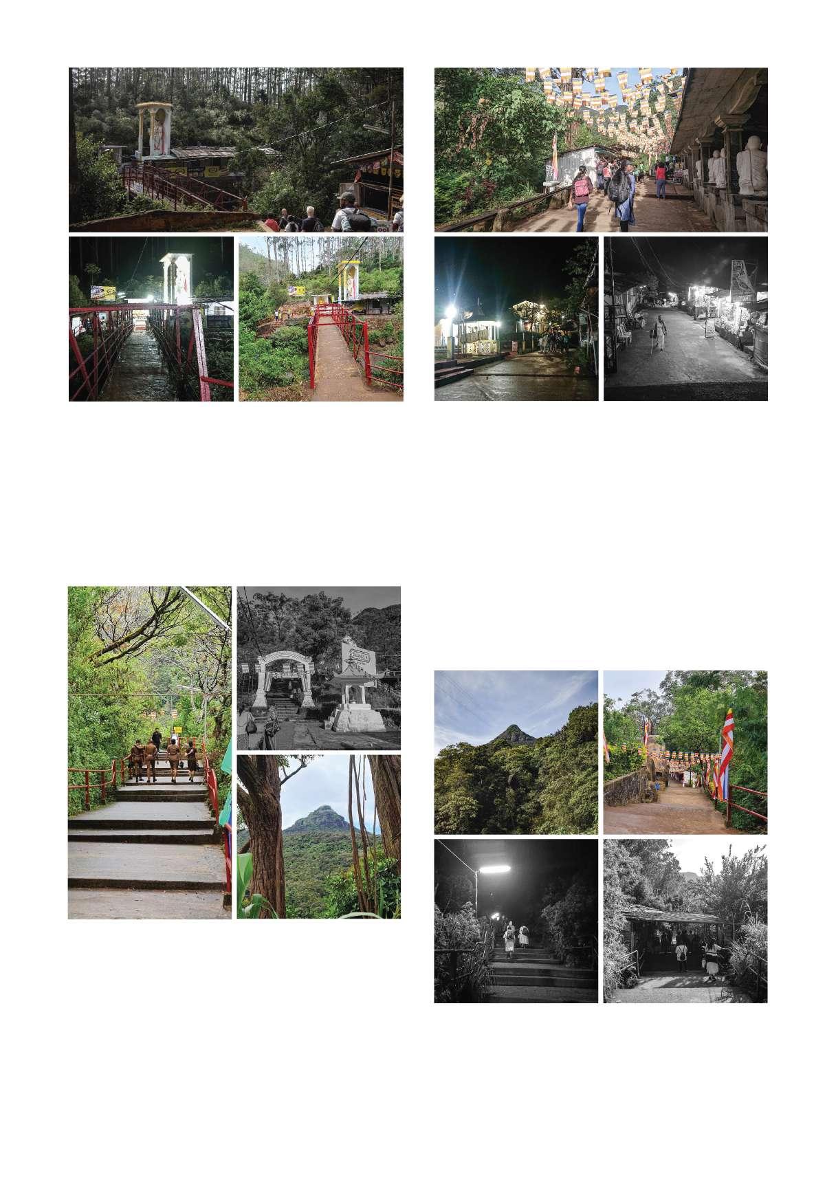
4.5. Trails of Sri Padaya
There are many Trails of Sri Padaya, starting from different villages that are in the vicinity. However three main trails could be identified. The location and relationship their surrounding social cultural elements depends largely on the region of the trail where it starts from. Erathna and Palabadala trails are the Historic trails and Nallathanni has been in use since the British occupation of the island. Access from east, nallatanni is a result of exploiting land for the purpose of tea cultivation and hence have been populated for only around 200 years.
Maussakelle Reservoir
Adam’s Peak
Maliboda
Hatton
Ratnapura Palabaddala
Erathna
Nallathanni
Three trails
Palabaddala Trail
Nallathanni Trail
Erathna Trail
Off-Season
From full moon day of May to Full moon of December.
During this period Pilgrims avoid the trails due to many reasons. But mostly the heavy rain during this time. water shed along the lowland rain forest area fills up while all trails and shallow spaces of the terrain gush with rain water. mist and wind also makes it extremely difficult to reach the top.
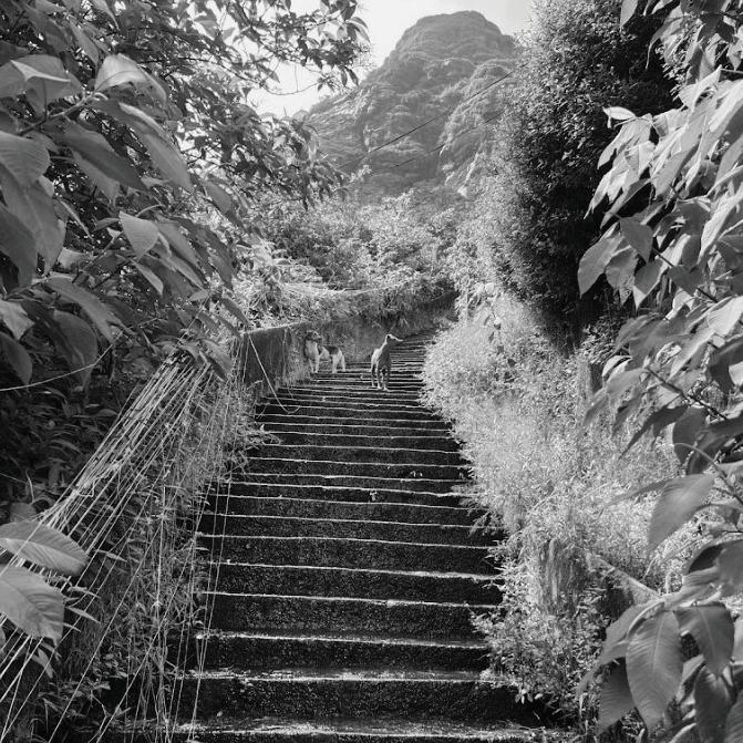
Another important fact is the return of the wildlife which went away during the pilgrimage season. During off season there are reports of leopards and even elephants seen along the trails, walking on the stairs.
even tho this is the case many people tend to travel in off season as an adventure. but the shops accomodations, and most conveniences are not available during the off season, including lighting along the trails at night, which limits people hiking at night during off season.
Fig: 21
Source:(Top Right - Jithmi Alwis, Rest Google maps, Sri Palabaddala)
Fig: 23
Source:(Google Maps, Sri Padaya-Kuruwita Erathna Trail Start)
Fig: 24 Off season of Sripadaya
Source:(Google Maps, Sri Padaya)
Fig: 22
Source:(by Author)
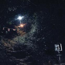
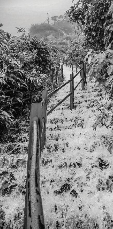
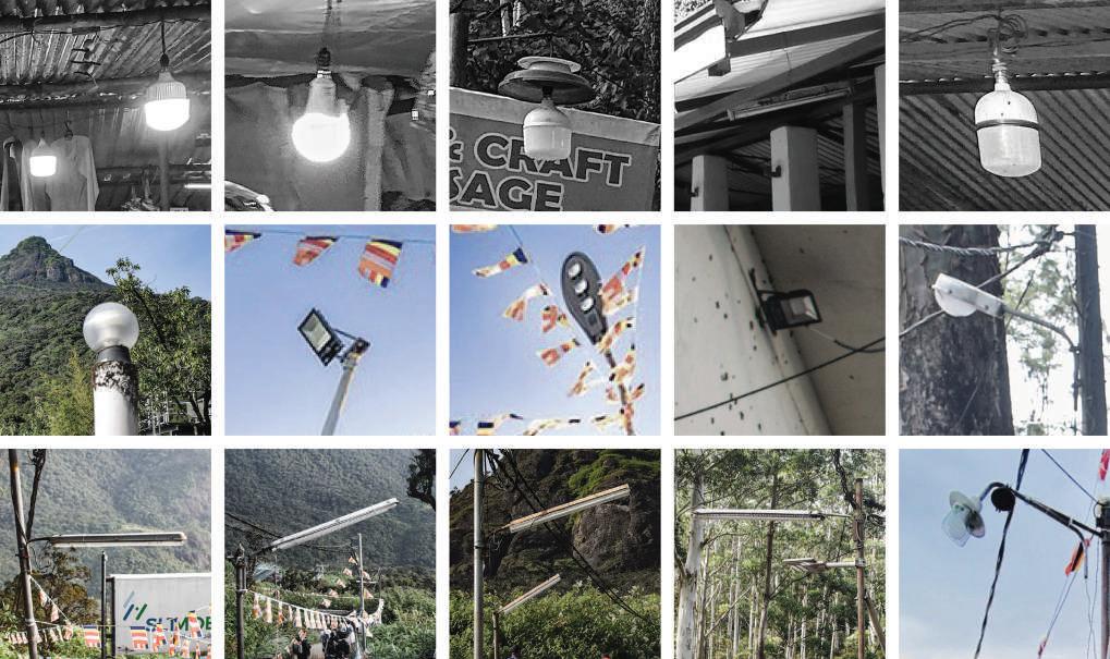
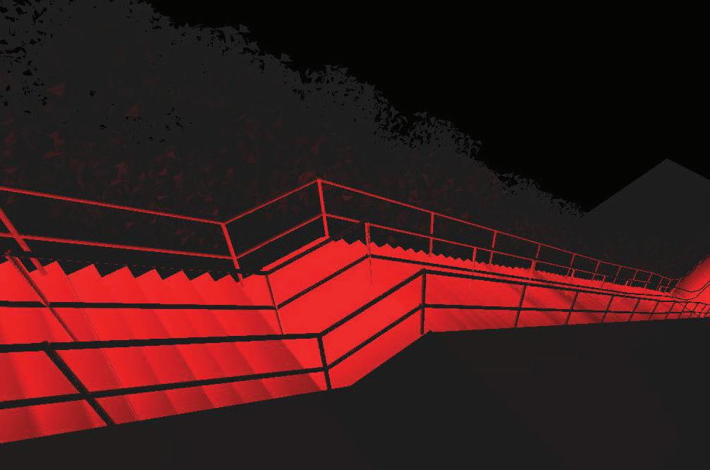
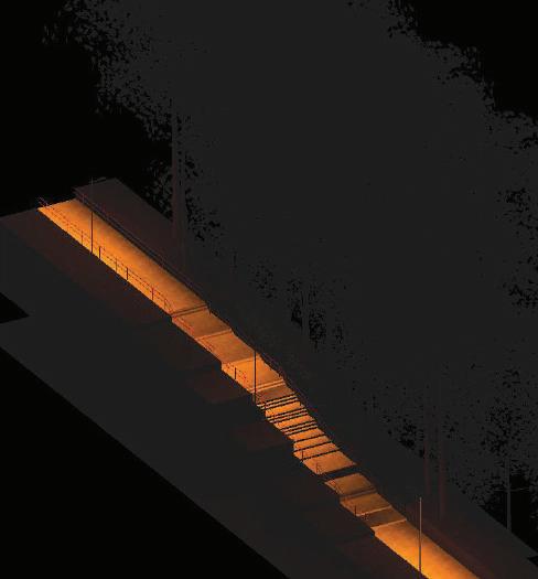
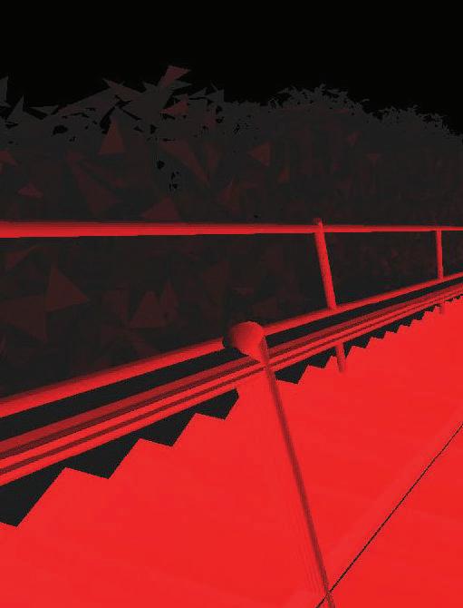
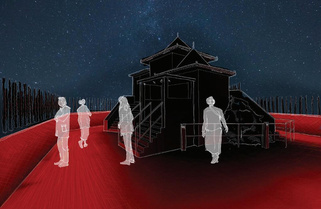
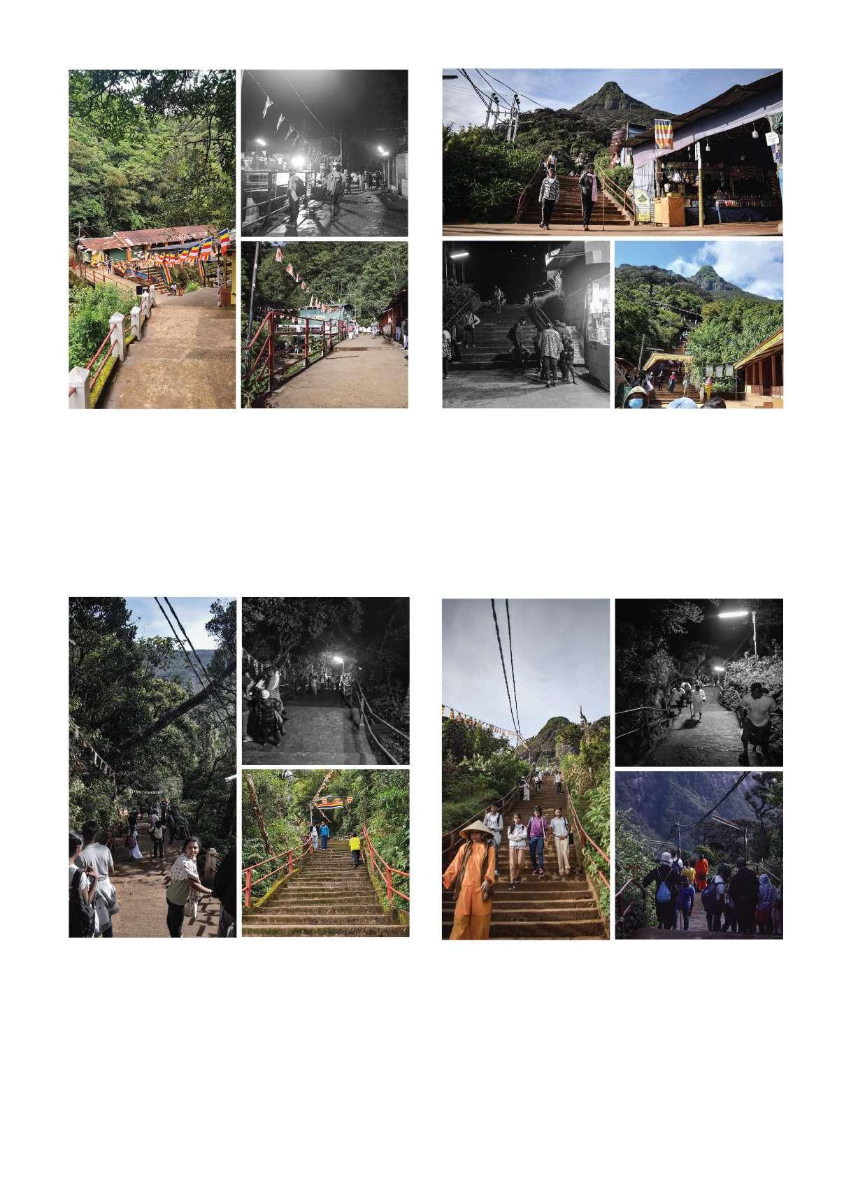
4.5. Anthropogenic Light at Night in Peak wilderness sanctuary
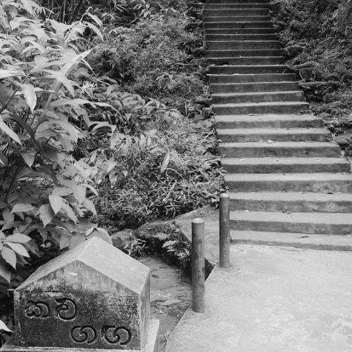
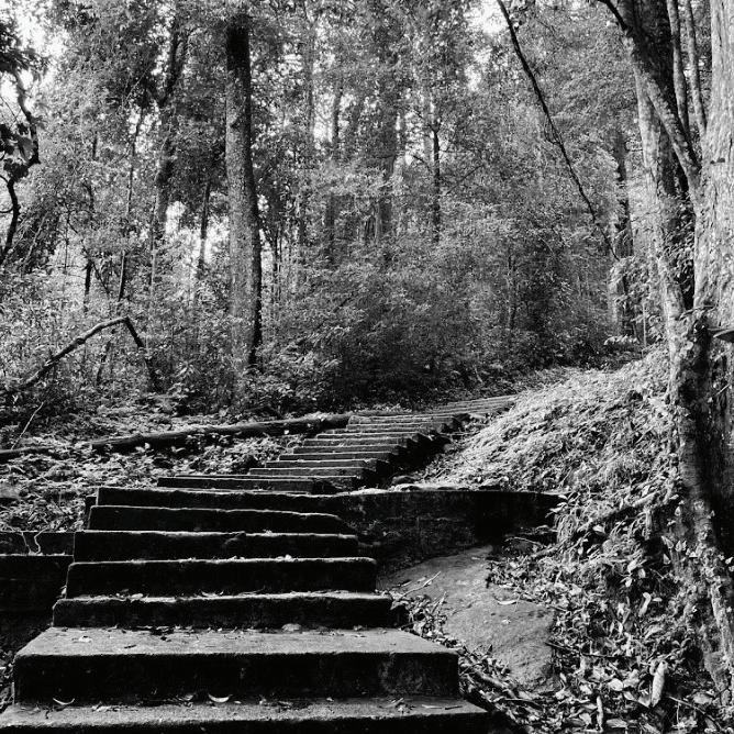
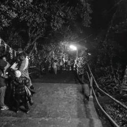
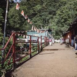
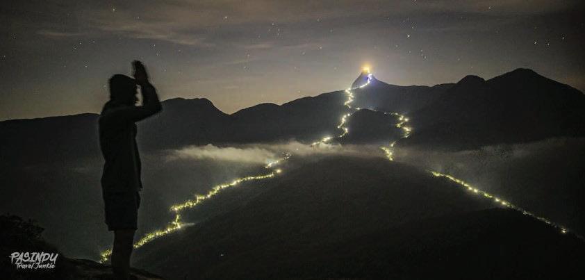
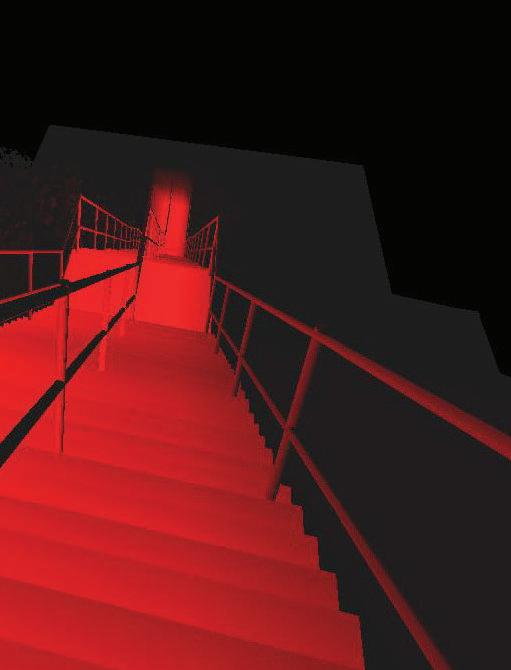
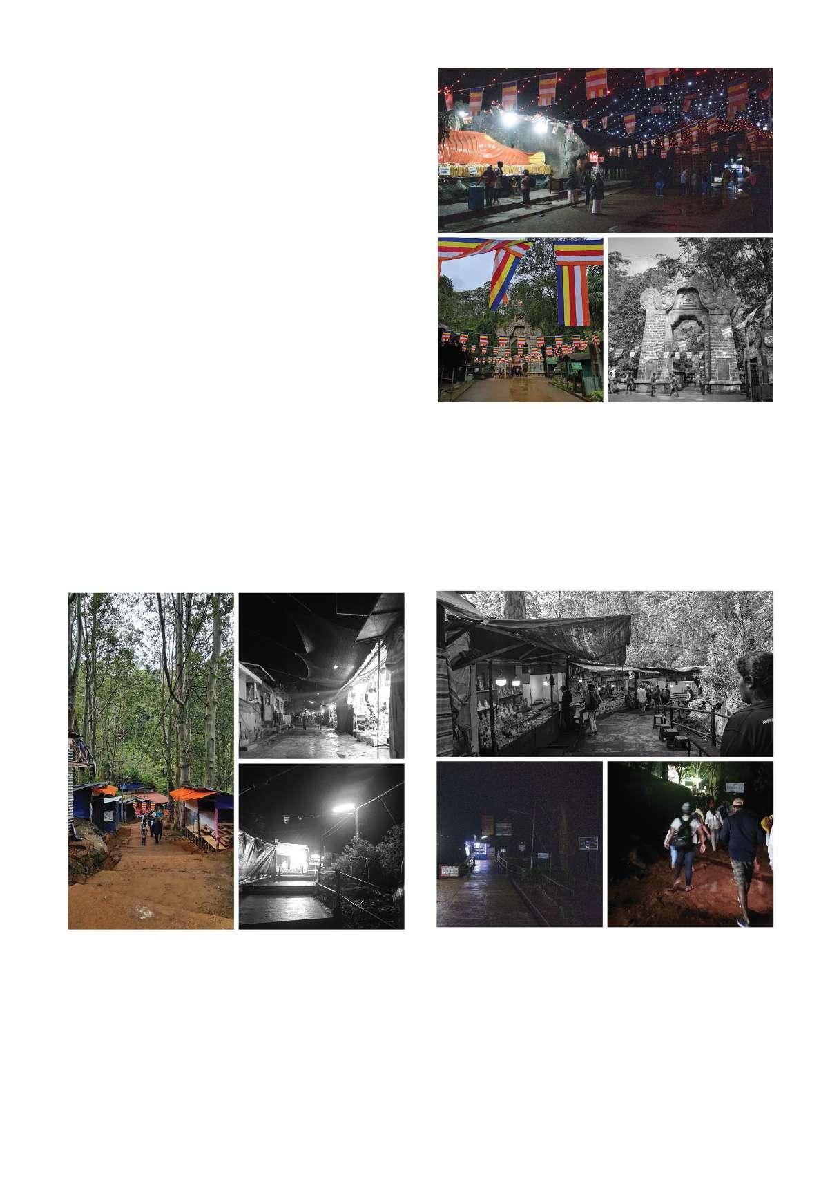
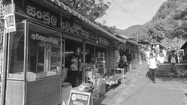
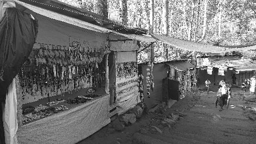
The light sources used can be easily identified as low quality and are very poorly planned. Trails are illuminated with unshielded luminaires and the impact towards wildlife and light pollution can be assumed as significant.
A key presence of anthropogenic light at night are light sources used by temporary shops and, other facilities, temples or resting pavilions along the trail, none are well planned.
Top right Nallatanniya trail (Source: John Crux Photography)
Bottom - Erathna and palabaddala trails seen From Kunudiya Mountain (Source: Pasindu Sandaruwan)
Fig: 25 Off season of Sripadaya
Fig: 26 Light sources found along the trails (source - Author)
At the summit
Found at a Temple
Found at Temporary shops
Found in Resting Pavilions
Mostly along Palabaddala trail
Mostly along Nallatanniya trail
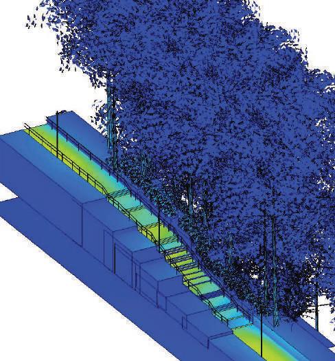
4.6. Analysis of all trails
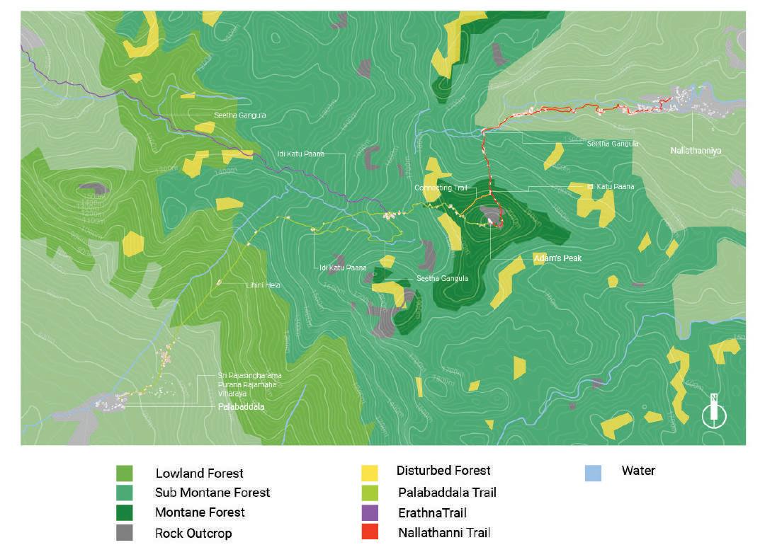
Data gathered from observations, surveys and interviews were mapped to create the following maps. The maps were developed using google earth and based on maps available from Biodiversity Baseline survey; Peak wilderness sanctuary. (Department of Wildlife Conservation Ministry of Environment and Natural Resources, Sri Lanka, 2007). Vegetation distribution Terrain
Fig: 27 Vegitation distribution of Sripadaya
Source:(by Author, adopted from Biodiversity baseline survey- peak wilderness sanctuary)
Fig: 28 Terrain of Sripadaya
Source:(by Author, adopted from Biodiversity baseline survey- peak wilderness sanctuary)
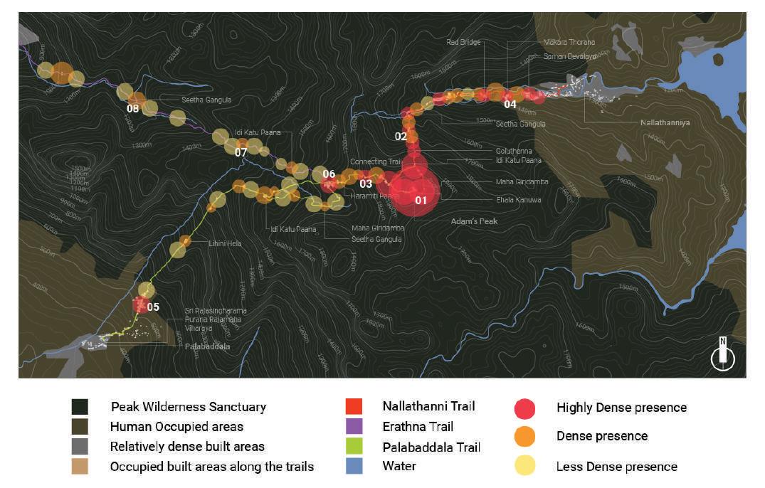
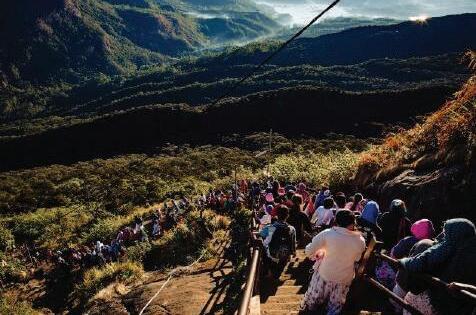
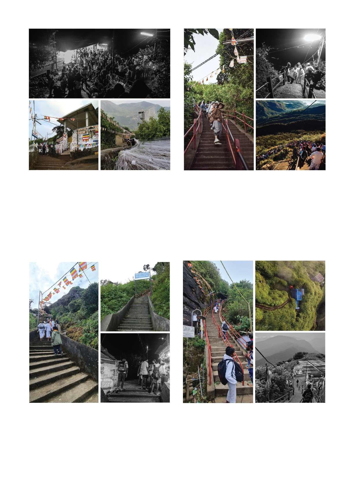
Most activity is seen along the Nallatanni trail. Most human presence can be observed at high elevation since travelers from all trails gather towards the summit. Even though the diagram shows an average understanding of the traffic level, depending on the time of the day the traffic of a certain area may differ widely. For example, relatively high traffic area such as 03, would be a relatively less traffic area past Sunset (18.00-21.00). The most high traffic or presence could be observed on high elevations closer to the Adam’s peak, past 04.00 to sunrise.
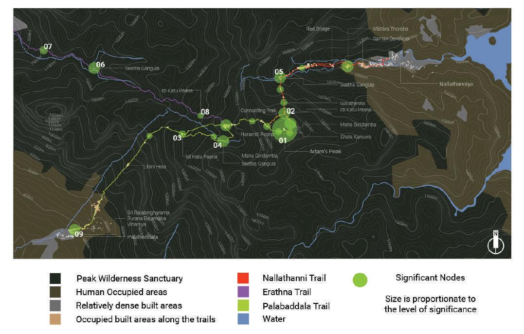
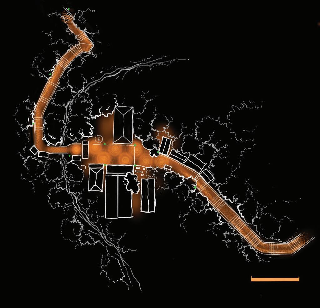
Identifying Socio-Culturally significant Nodes
Nodes that are significant for the pilgrimage are found on all three trails, which are named with the same name; such instances are – Seetha Gangula (04,05,06) and Idikatu Paana (02,03,08). They serve a purpose during the pilgrimage and presents value as a cultural node Palabaddala trail and Erathna trail are the trails that were taken for hundreds of years. And they also have ties with special religious and cultural events or parades. But none take place at night. (07,09; are prominent starting points with historic Buddhist temples) Nodes also present a significance in the social context of the travel, considering the presence of rest stops where people gather.
Fig: 29 Traffic flow of Sripadaya
Source:(by Author)
Fig: 30 Sociocultural significance of Sripadaya
Source:(by Author)
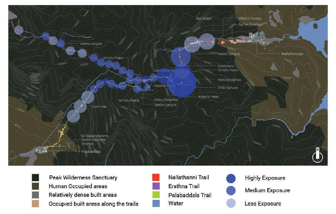
Considering the vegetation and open spaces (observed via satellite images) found along the trails, the following interpretation was built. Even though this is the case, considering that the entire trails are on a mountainous rough terrain, there are many factors that contribute towards the exposure of trails towards the sky. This analysis allows us to understand the spatial aspects of the trail on a wider scale.
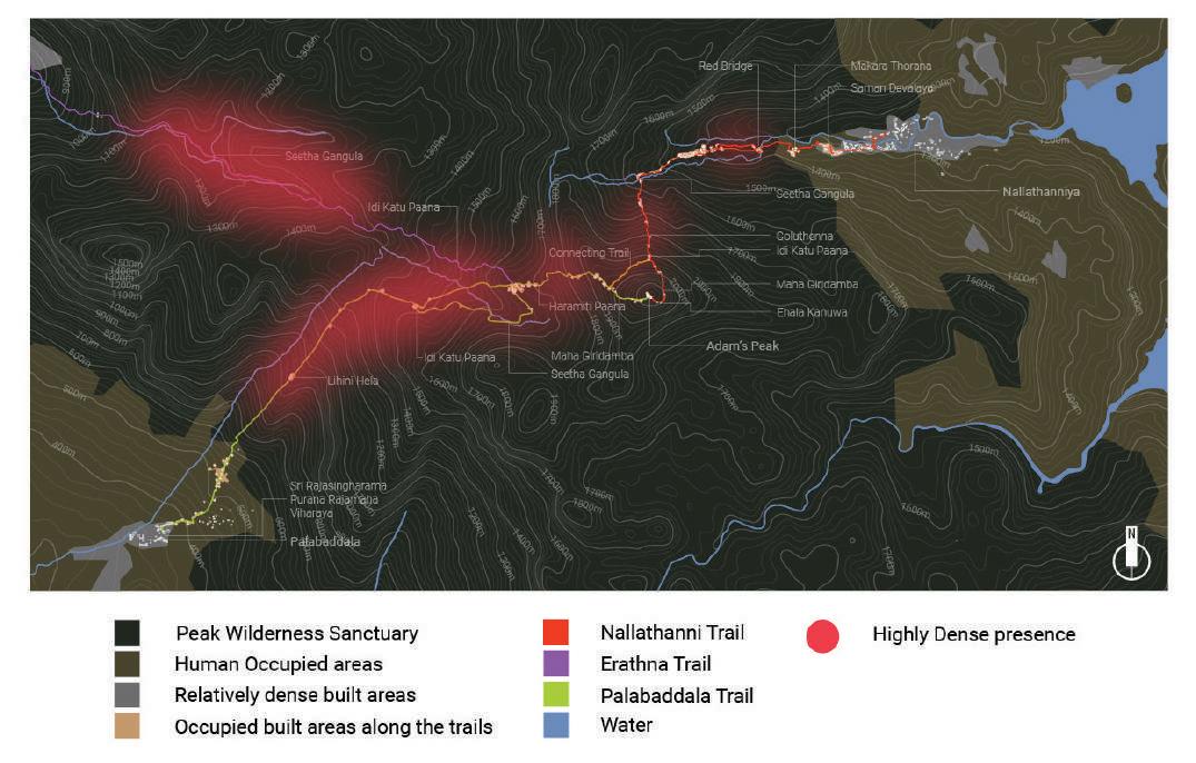
Identify potential areas for Conservation Efforts
Species density, lack of disturbed environments (invasive species, disruptions, pollutants, etc) were considered to identify these hotspots that cross with the trails. Even though not Flat, Erathna trail travels through a gradual range of elevation difference for the most part, until the junction with Palabaddala trail. This and the fact that the trail is along water sources makes Erathna trail the most sensitive trail towards ecological sensitivities at lowland Rain Forest range. The species range is also high at this elevation range.
Fig: 31 Exposure of the trails of Sripadaya towards sky Source:(by Author)
Fig: 32 Potentaal areas for conservation in Sri Padaya Source:(by Author)
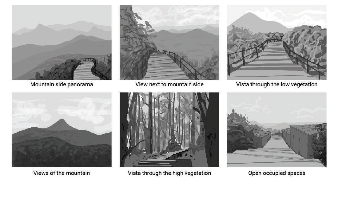
Considering the observed, photographed spaces from the initial site surveys, following views and vistas were identified. They are characterized by the view of the landscape, vegetation and exposure to sky. Moreover, presence of build structures were considered to determine active presence of travelers.
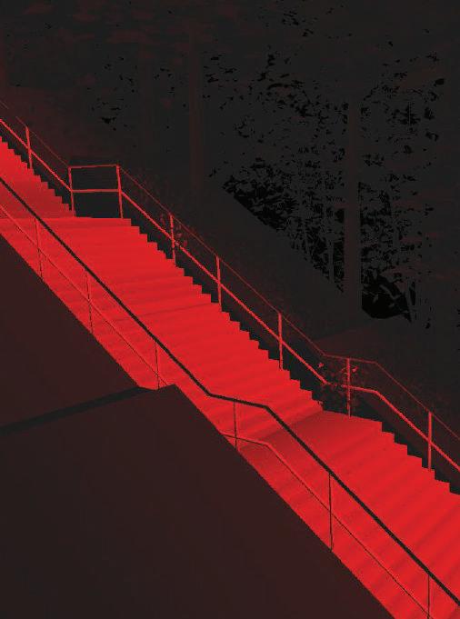
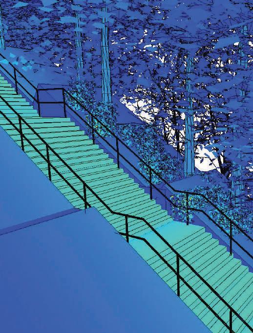
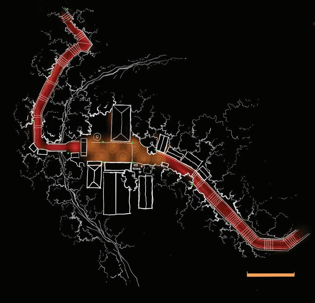
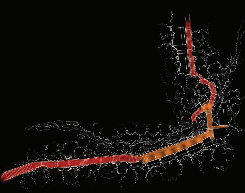
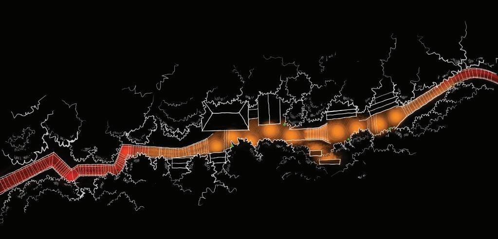
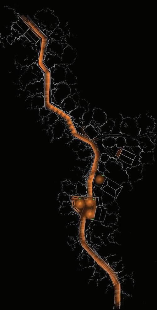
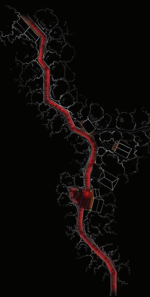
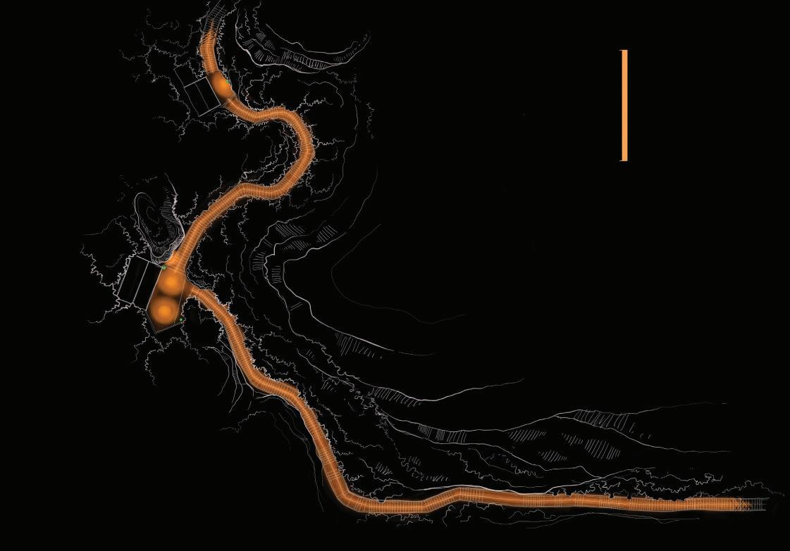
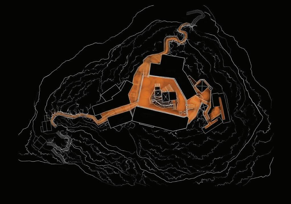
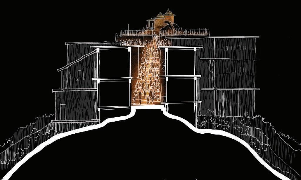
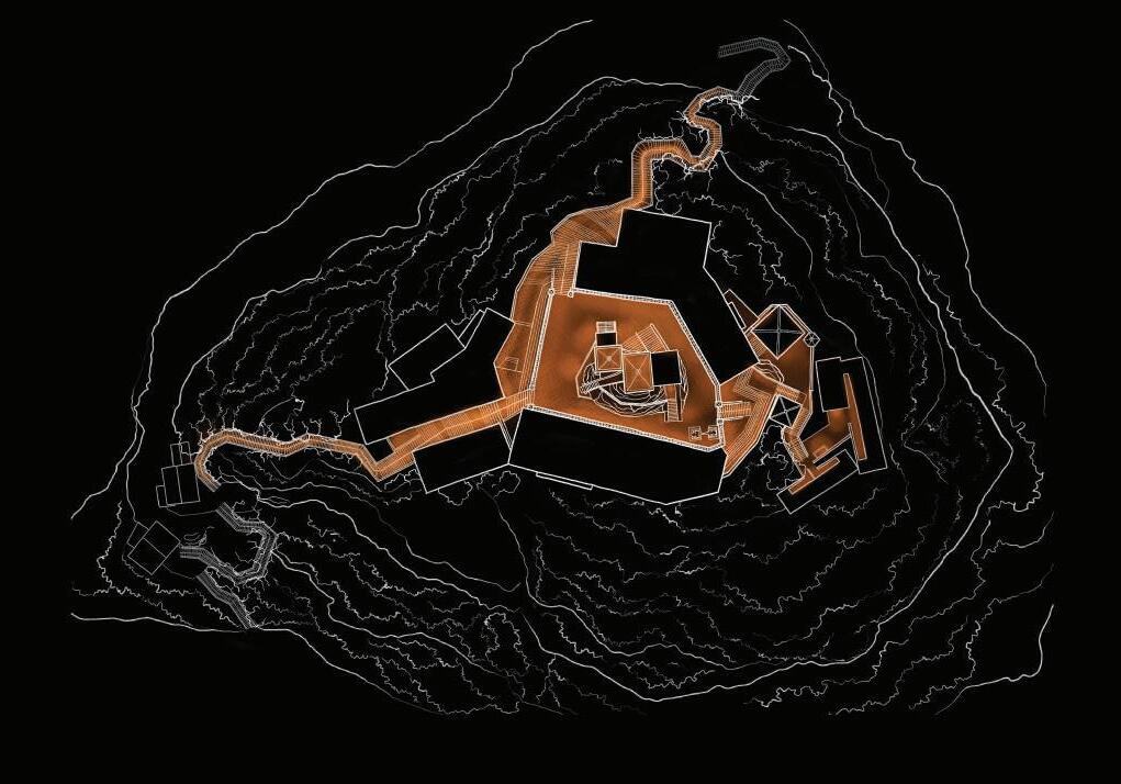
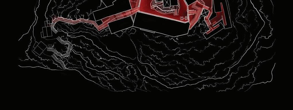
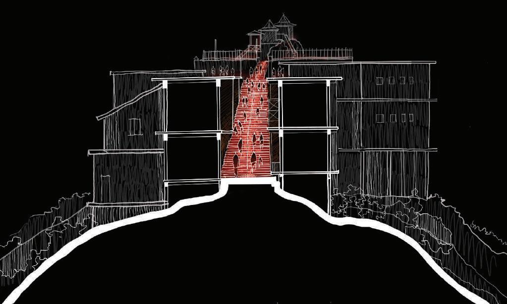
4.7. Nallatanniya Trail - Spatial Analysis
Nallatanniya trail being the most prominent trail that is used by majority of pilgrims and travellers allow us to focus on creating an impactful change towards ecologically sensitive, responsible lighting along the trail. Also considering the palabaddala trail closer to the summit. The significant nodes and sections of the trails shall be identified for the purpose of design intervention.
The identified nodes and trail sections were analyzed using Photographs and observations from the surveys. This spatial analysis is mentioned under “Appendix A” Process of selecting nodes evolve around the pilgrimage and ommits temporary shops and structures, these structures would be only considered in the purpose of presenting recommendations for responsible lighting practices which would support the concept as a whole.
Fig: 33 Serial Visions of Sri Padaya Source:(by Author)
Fig: 34 Nallathanniya Trail of Sri Padaya Source:(by Author)
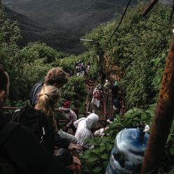
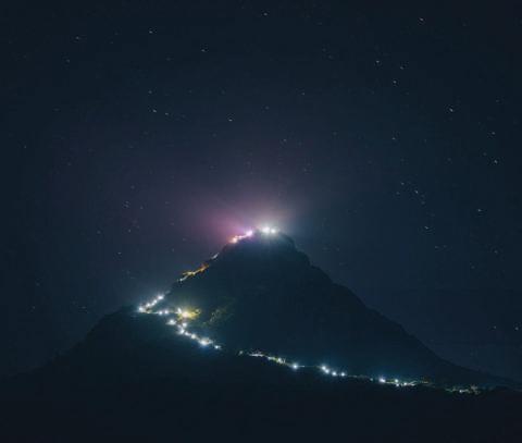
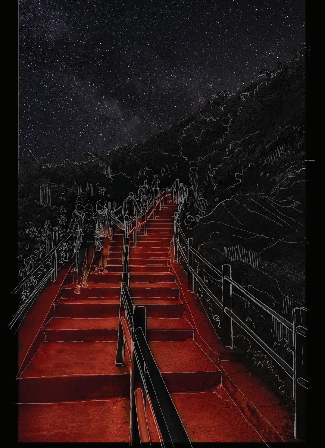
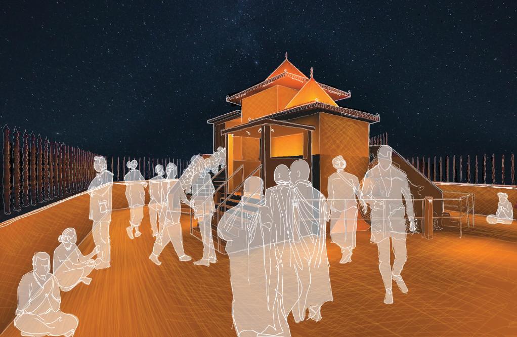
Anthropogenic light at night in the context of Sri Padaya trails and peak wilderness sanctuary is dominant. Raising to high elevations and being visible from hundreds of kilometers away at night; one could say that the stakeholders do not limit only to the ones present in the context. Considering the social cultural significance of the context towards the locals; as a symbol, as an icon, anthropogenic light at night has of significant importance to the Sri Lankan community in the recent years. However, at what cost? Simply put, stakeholders of the context at large are in two main categories; ones who need Artificial means of lighting, and the ones that didn’t ask for it – Nocturnal wildlife and nature.
Understanding the human stakeholders and their perception of the trails, need for light at night and empathy towards them is critical for a functional presence of light, while bringing the experience of true nocturnal nature under a dark sky. While accommodating the human experience it is important to be conscious of the nocturnal wildlife and it is a designer’s responsibility to create a balance between the needs of the two, and to vigorously minimize irreversible impacts of irresponsible interventions.
User analysis,the travelers Observations/Conversations / Survey through questionnaire
Shops and persons involved with regular presence in the context
Observations/Semi Structured Interviews
Ecology and Biodiversity
Observations/Qualitative research/ Semi Structured Interviews with experts
5.1. Human Presence
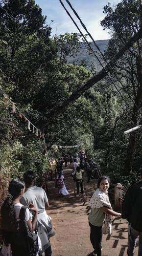
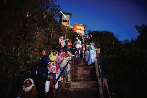
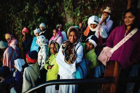
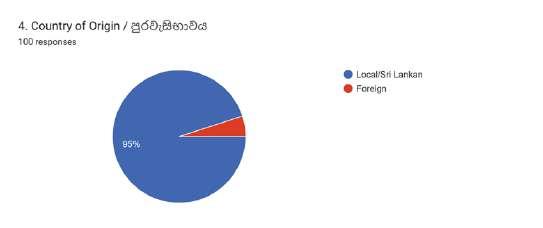
As already mentioned, human presence at night in the peak wilderness is driven by the travelers and pilgrims. Even though the purpose of presence might be similar, the demography is very broad. From locals to foreigners, toddlers to elderly, people of various faiths and beliefs and so on.
Furthermore, for a critical understanding of the stakeholders, several survey methods were used. During the initial site survey, observations were recorded as photographs and notes from the survey group. Another source of information, and in-depth relation with the stakeholders was through various mediums of blogs that were found on the internet. Including written blogs, photographic documentations and video blogs. The video blogs were specifically informative regarding the conditions of all trails including Erathna trail and Palabaddala trail. It is also a possibility gather heartfelt insights in to the context from the users.
“I stumbled as I was carrying tea back to Seema and I fell and crashed in slow motion. Everyone laughed at me including the monks and myself! We could not stop laughing. Then, a sweet sweet family felt bad for me and offered to buy me another tea! It was a gesture I’ll never forget. The experience of this climb was “we’re all in this together,” and it’s felt through the journey.”
source: (Camille, 2022)
The togetherness between the fellow travelers is a key trait that was observed as well. From people supporting anyone who struggles to climb, sharing food or drinks, friendly motivation and charming interactions between groups of people moving in both directions. During dark hours it is also seen that people travel in groups and rarely alone or as a pair of people.
5.1.1. User analysis, the travelers
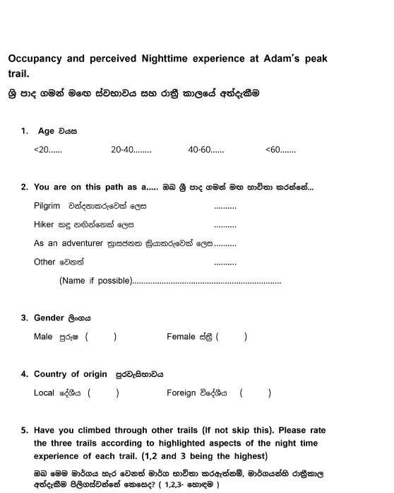
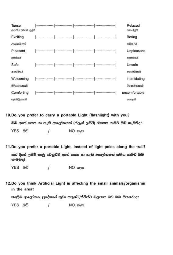
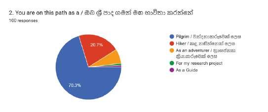
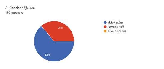
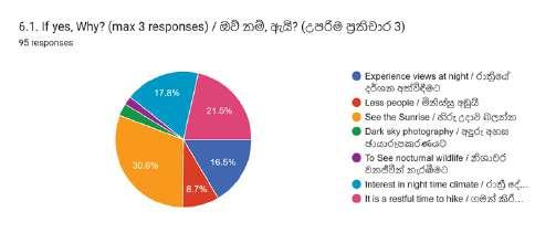
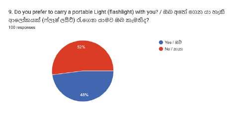
Based on the initial survey a questionnaire was formed. Focusing on identifying following key insights. Demography, connection with all three trails, perspective on hiking at night on Nallatanni trail, perception of artificial light on Nallatanni trail and preferences.
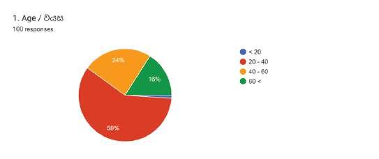
The questionnaire was answered by 10 travelers, on the Nallatanni trail. The questionnaire was also utilized as an online survey for the recent local travelers, where 90 responses were collected. The questionnaire and all responses are attached under “Appendix B”
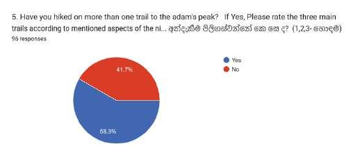
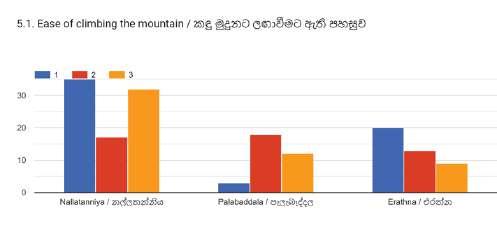
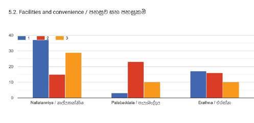
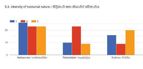
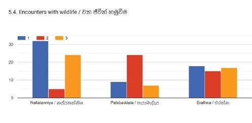
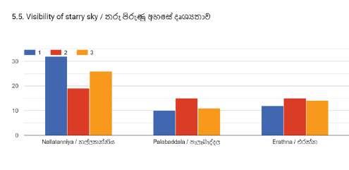
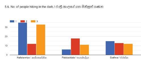
Majority of the users responded in the context of sri padaya trails identified themselves as pilgrims. Regarding comparison of three trails, Nallatanni was the most taken trail and also the most preferred by the users. However, in section 2 of the questionnaire, a mismatch of the responses can be seen regarding rating the three trails in different aspects (such as ease of)climbing, encounters with wildlife). This could be a result of miscommunication through the questionnaire.
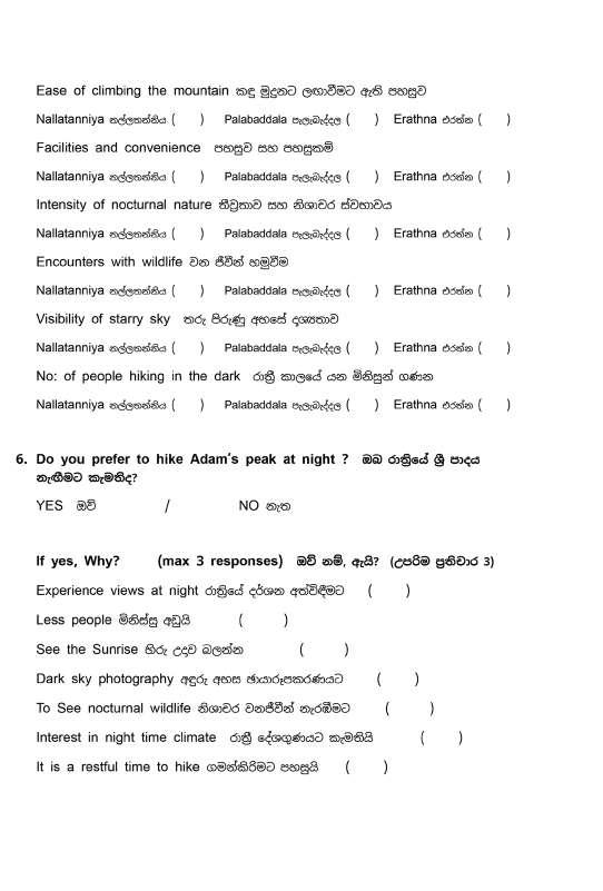
For most of the responders, the reason to hike at night was driven by the need to see the sunrise from the top. Another reason could be seen as the preference for nighttime climate, views of night landscape and restfulness of the night.
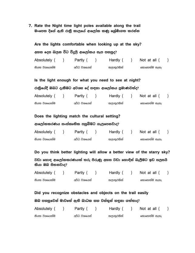
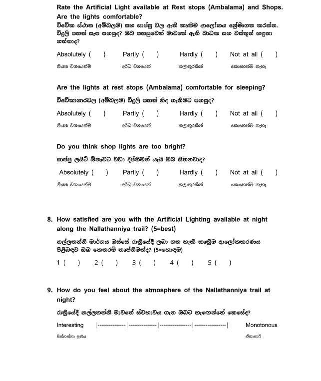
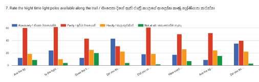
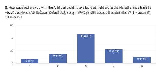
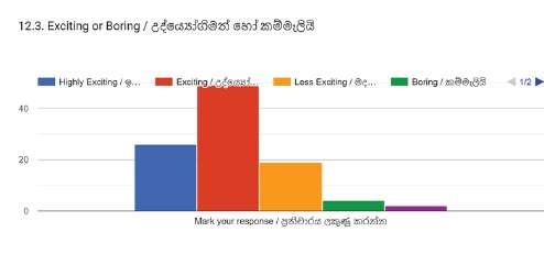
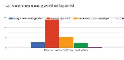
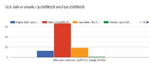
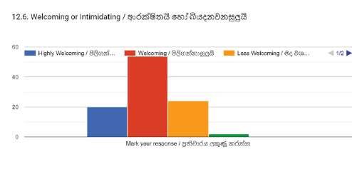
The majority rated the existing lighting along the trail as a 3, between 1-5 (5-highest). Rating of current lighting situation also resulted in the following insights. The majority identifies the potential of better lighting situations resulting in a better perception of the night sky. And are aware of the possible impact of anthropogenic light on wildlife. .
The responses in general were not polarizing when rating the current situation based on comfort, safety and ease. However, users do notice that the lighting situation does not match the cultural setting of the trails. Considering question 12, regarding the nighttime hiking experience along the trails, mixed perceptions could be seen. Even though most results lean towards the positive end of the aspects considered, it should be a concern that there are considerable responses leaning towards the negative end (uncomfortable, unsafe, intimidating and tense).
5.1.2. Personas involved with regular presence in the context
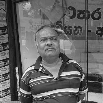
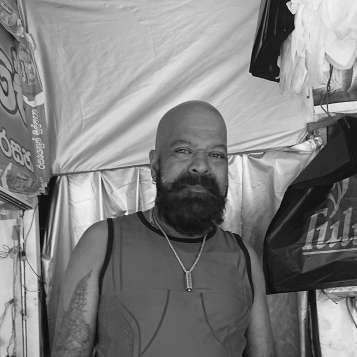
Shops
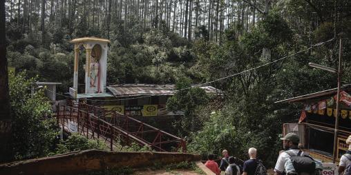
Semi structured interviews were conducted with the shop owners along the trail by the survey team. Semi structured interview methods were chosen to create less boundaries for the conversation, with the intention of new and interesting insights from the people that were interviewed. The structure used for the conversations is attached in “Appendix D” Based on the conversations, shops usually are set up after the off-season, and after each pilgrimage season they are taken away or stored safely. This is because of the heavy rain and other damage that might happen due to wildlife or weather. The shops are built with cheap easy to find materials and so is the electrical lighting found in these shops. Shops are being set up by the community in the area. During the night, most shops at the start of the trail are closed, but they keep the lights on; thinking it would help the pilgrims who travel at night. Also considering people seated on the other side of the trail from the shops, shop owners try to provide light in side the shop and outside using very few luminaires. Shops closer to the summit are open 24hours.
Fig: 35 Human presence of Sri Padaya Source:(Camille, 2022)
Almost all shops and other buildings use white light (>4000K), they base the decision on the “lively atmosphere” it would create, and also in cases where souvenirs or cloths are sold; for the purpose of color visibility.
Guides
The guides (Nade gura) are not only limited to the community surrounding the mountain, but an experienced person, which guides a group of pilgrims to the summit. They are well experienced in the pilgrimage and hike the trails regularly. Mr. Senarathna is one such guide from southern Sri Lanka, and he hikes the Sri Padaya Mountain at least once a year. The following information regarding usual starting times and ascend of all three trails was collected via a conversation with him. According to him these times vary according to the fitness level of the group. But with the focus of visiting the summit at sun rise; flow of the pilgrims tend to always follow a pattern. Other than that, according to Mr. Senarathna; flow of the hikers towards the summit is much less during the evening due to possibly sunny conditions. Therefore largest groups start to hike the mountain at night (to see the sunrise), or early morning (due to comfortable conditions).
Identified
Least
High
5.2. Persona Study
Based on the findings from the initial survey, second survey and interviews, following set of personas were formed. These personas present a clear understanding of the requirements and need of the stakeholders and potential interventions to allow dark sky experience and potential level of ecological conservation efforts.Personas range widely. As mentioned previously; multiple ethnicities, all ages, all nationalities travel these trails.
And their reason for being on the trail is also mostly the same, and they move along the same trail, rest in the same places and facilities and conveniences available are just the same as well. Therefore personas tend to accumulate as a group of people. Based on the surveys conducted, the following personas could be identified but their needs and requirements in the context vary, very little.
The Monk
It’s not his first time, so getting to the peak is not that exciting. But he knows it’s all about the journey.
The Foreign Pilgrim Devoted and determined to face the challenge of the climb. She takes her time, not in a hurry to finish the spiritual journey.
The Elderly Pilgrim She is on a spiritual journey to visit the summit and worship the famous footprint, with nostalgic memories of past visits to the summit.
The Guide (Nade Gura) He feels responsible for the group of pilgrims, and keeping the group motivated is half his job.
The Foreigner
Enthusiastic and connects well with the crowd, but he always waits at a scenic place to capture the perfect shot.
She is excited to be on this journey and wouldn’t know what to expect, but bravely move forward.
The Local youth
It’s probably his first time climbing the mountain. Excited to get to the top. Enjoying every minute of the adventure.
The Police officer He finds himself at his post. When the time comes he helps the pilgrims in need and respond to any emergency..
The Vlogger
Fig: 36 The Diagram of hiking time
Source:(Camille, 2022)
starting time periods of the pilgrimage
amount of people start pilgrimage around this period
traffic time in the montane region
Nallathanniya Trail
Palabaddala Trail
Erathna Trail
As discussed in the spatial analysis, there are several temples and few nodes which have public services. Such as police posts, post office and medical centers. Here we could see another persona, who travel the trails regularly. but it is also found through conversations that the people who travel regularly tend to travel in the daytime. However there are scenarios where if there is an accident or a medical emergency; staff from the closest medical center rush to the scene and carry the patient on a stretcher quickly to the medical center.
5.3. Ecology and Bio diversity
As described through the last chapter, Sri Pada holds a significant importance when it comes to biodiversity and ecological significance. Presence of exceptional species density of endemic species which are only found in this sanctuary makes the sanctuary quite unique. Even though the significance of the ecosystem is clear, even the ecologists agree that there are many species yet to be discovered and identified in the area.
However, when it comes to understanding the impacts of anthropogenic light towards the eco systems; the research is quite low. Therefore considering the biodiversity of Sri padaya, and in order to identify needs and requirements that should be considered for the purpose of conservation, the study takes two approaches. A general understanding of light sensitivities and vision systems of different species groups and vision systems of different species groups and several semi structured interviews with experts in biodiversity of peak wilderness sanctuary.
Vision systems and behaviors of animals
As previously mentioned in the literature study it is prevalent that the animals vision range widely and often quite sensitive towards low light levels; considering behavior changes based on changes in natural light at night.
Following figure presents a much general idea of the light sensitivity between different species.
Evolution has gifted the amphibians with a vision system that function in water and on land. Other than the eyes their skin also has a significant sense of light. How ever amphibians have high sensitivity towards light and low acuity. Resulting ability to detect minute changes and not much in static. Their adaptations to see under water hints of their sensitivity to blue light. species that dwell only in water tend to have photoreceptive cells that pick up UV light. their color vision range from ~300nm to 700nm. Visibility of vivid colors is an essential factor for mating and foraging for frogs and toads. (Amphibians, 2012) (Stebbins & Cohen, 1995)
As discussed earlier nocturnal bees have high sensitivity towards blue light. This is the case for almost all nocturnal insects. Leafrollers are commonly found family of moths and their three photoreceptors classes peaking at 355nm, 440nm and 525nm. (Gabarrella, Gemeno, & Belušič , 2023)
Fig: 37 Comparative light perception among different species groups
Source: (Department of Climate Change,Energy,the Environment and Water, 2023)
Structure was framed to understand several key factors. Mainly, species distributions in the context, movement based on seasons and time of the day and observations of wildlife during dark hours of the day. The structure was a mere guide for the conversation and through free conversation allowed interesting insights from the experts (Mr. Sanoj Wijayasekara, Mr. Amila Prasanna Sumanapala). The information regarding the experts and structure for interviews are attached under “Appendix D” insights from the survey are as follows,
Distribution of biodiversity
The significance of diverse vegetation based on elevation allows a diverse range or animals to move between the zones depending on the changes in temperature or climate. This aspect essentially presents us with a shifting population of organisms, with few identifiable behaviors in certain areas. Through observations, it is seen that the species density is high on areas of flat land with significant access to water. Considering the trails, the trails from Erathna covers such an area. Speaking of the diversity along the trails, it could be observed that several microclimate conditions and elevations allow very different species combinations to thrive.
Nallatanniya trail
Nallatanniya has the least presence of animals in the area due to high disturbances. Nallatanniya trail also starts from higher elevation and does not include the continuation ofdiverse vegetation and species composition along with it. Initial part of the Nallatanniya trail contains introduced plants to the area and occupied tea plantations.
Amphibians
Amphibians are found all over the sanctuary and depending on the elevation and rain forest type, species composition may vary. Shrub frogs are the most commonly seen frogs seen in the sanctuary. their behavior: the males call for mating and usually remain in their habitat. They pray on the insects that come into their vicinity. Considering the areas where amphibians lay eggs, their habitat cannot be tied down only to water ways as well.
Reptiles
While there is a high number of reptiles seen in the lowland rain forests and submontane rain forests, less number of species are observed in higher elevations. This could be attributed to high elevation and low temperatures.
It is commonly observed in the amphibians and reptiles that they tend to have low presence on full moon nights. Predator detection is regarded as a possible reason for this behavior. It is also commonly regarded that the amphibians and reptiles are highly sensitive to light.
Nocturnal Birds
Many nocturnal birds could be seen in the lowland rain forest area, such as the endemic species, Serendib scops owl. But not many nocturnal birds have been observed in cloudy montane rain forests at high elevation. Smaller bats (Kiri wawla) is often seen hunting insects along the trails at night. The insects that get attracted towards artificial light allow easy predatorial behavior for these bats.
Migrating birds such as Kashmir fly catchers, are also commonly sighted in the peak wilderness
Aquatic animals
Fresh water fish are less and less in higher elevations and not many in the areas crossing with Nallatanniya trail. In Erathna trail however has the most possible habitats for a diverse range of freshwater animals, among the trails. Corrugated Water Frog (Lankanectes corrugatus) is a species which limits it’s habitat from egg to mature frog, only to water.
Dragonflies are also another species which roam mostly around water sources, they ley eggs in water and hence a significant presence around water.
Freshwater crabs which dwell in shallow water, are another less explored species in the peak wilderness where most freshwater crabs here are endemic to the area.
Insects
Butterflies, Dragonflies and Moths could be considered as the most observed in the peak wilderness, when considering behavior driven by light at night time. The species range is wide and also many non identified species exist.
The dragonflies, moths and insects are naturally attracted towards moon light. On a moon lit night; these species move towards moon lit sky along the elevation, moving higher (this process is identified as hill topping). This presents two positive evolutionary processes.
Due to winds in higher elevation, they get dispersed to different locations. Another is that a variety of species gather towards higher elevations or mountain peaks, from a broad area. Both factors contribute to gene mixing and resulting a healthy population of moths, dragonflies and other insects that are attracted to light at night.
It is observed in trails of Adams peak, many insects that get attracted towards Artificial lights and never get to make their complete journey. Or becomes a pray for bats and other predators which take advantage of the lights attracting these insects
This chapter attempts to gather all the data and information from the previous chapters in to a Framework for the purpose of creating a holistic, comprehensive overview of the context based solutions that would be explored by the design proposal.
Initial meta-analysis based on previous analysis allow a comprehensive understanding of the Nallatanni trail, in relation with time, vegetation, significant nodes and a overview.
6.1. Framework plan
Detailed analysis of Nallatanniya trail
Ecological Social Cultural study, and insights
User surveys, personas
Map analysis of 3 Trails
Meta analysis of nodes along Nallatanni Trail
3 types of nodes were identified Detailed understanding of Nallatanni trail
Master plan identified with types of nodes
Time plan for Nallatanni Trail
Lighting design proposal
Guide for ALAN in the context
Design outcome
Active Node
Intermediate node
Ecological priority
Summit Scenarios
6.2. Meta-Analysis
The purpose of the Meta analysis is to understand the context holistically and the Table of Meta analysis enable a complete view of the factors that shall be considered with regard to identified nodes and trail sections of Nallatanni trail.
Here, it is approached only to Nallatanni trail with the potential application of findings to the other trails, after attentive research on the other trails as well.
Identifyed nodes / Node Types
Active nodes
Active nodes are areas along the trail that are complex, when it comes to demand for lighting at night. And are with high human activity. These nodes would have social aspects such as Resting pavillions or medical center, Cultural aspects such as temples, statues or monuments. They would also serve as places for shops. even though high activity is observed in these nodes
Intermediate nodes
These sections of the trail and nodes are areas which has high traffic at times, and are still very sensitive when it comes to visibility of Night sky and Impact towards nocturnal wildlife. therefore they require solutions that cater to both of those needs.
Ecological Priority Nodes
These sections of the trail hold higher ecological risks and potential for high impact through conservation. And these nodes Also show relatively less traffic and hence ideal for sensitive lighting stratergies with concern on mitigating ecological impact.
The Identified nodes are on the right. They are based on the factors mentioned in the meta analysis table. the nodes are identified and mentioned by use of color in the table as well.
These three types of nodes and their light scenarios continue through out all three trails and would deviate in some cases such as Summit of Sri Padaya. Based on the analysis of the context considering all trails; these scenarios could be assigned to the trails based on needs of the trail sections. This is mentioned under “Masterplan of Identified nodes” (next page).
However, Considering the lack of research and attention towards Palabaddala and Erathna trails should be mentioned. Indepth analysis of the said trails are required to rationally, and acurately assign the selected scenarios.
For the purpose of a Holistic view of the context, 3 node types are assigned to these two trails based on previous analysis of maps and research of the context.
6.3. Master plan of identified nodes
Lihini Hela
Gangula
Seetha Gangula
Haramiti Paana
Connecting Trail
Maha Giridamba
Maha Giridamba
Idi Katu Paana
Seetha Gangula
Saman Devalaya
Makara Thorana Red Bridge
Goluthenna Ehala Kanuwa
Idi Katu Paana
Idi Katu Paana
Nallathanniya
6.4. Time plan for Nallatanni trail
Based on the Meta analysis table, and the node type following time plans were developed for the nodes and trail sections of the Nallathanni trail. These time plan diagrams determine different times of the night where specific nodes require specific lighting situations. and Hence maximizing the potential for conservation and preservation of dark sky, and ecology.
Saturation and outward extention of the shapes represent activity level. the most extended and saturated shapes are the highest activity and least is the lowest activity level.
The Hue of color represent Active nodes and ecological priority nodes. Ones with moth are intermediate nodes.
From Start of the trail until Seeth Gangula has the most shops and services. including medical centers and several Temples which keep the area active.
The potential for ecological conservation is also high considering water sources near by. However the vegetation is been disturbed by introduced and invasive plants, therefore making it less significant compared to the rest.
Red Bridge to Gangulthanna
Makara Thorana to Red Bridge
Seetha Gangula
Rathu Ambalama
Seetha Gangula to Rathu Ambalama
Makara Thorana
Gangulthanna to seethagangula
The Summit is a specific situation where attention for detail is significant in many aspects. Including it’s potential to cause light pollution, and highest traffic at certain times.
Close to sunset and sunrise a sacred ritual is performed, everyday; which last for around a hour.
Time plan diagrams are a result of meta analysis and others described. However, several assumptions were made inorder to create an overall understanding of the traffic levels. They include, assumed presence due to travelers that are decending from the summit, travelers that would rest at pavillions, and would be delayed due to unforseen reasons, interuptions such as rain, and so on.
Towards the summit the vegetation is low and potential for ecological conservation and dark sky preserving is high. panoramic views also allow the best views of the night sky.
However considering all trails gathering to the top and possibility for travelers to connect between trails at Idi Katu Paana; this area is very active close to the sunrise. therefore demands being an active region.
Idikatu Paana and upwards
Light as a medium for design, holds a unique presence. Whereas it is not physical and switching it off or changes create a dynamic presence through time. It is important to highlight the potential to not exist, which is quite unique. This means, time as a dimension takes greater importance considering the potentials of lighting.
7.1. Design Concept
Transcendent night
Darkness of the night is an experience defined by light, with its presence and absence. Setting the visuals and boundaries of space. The spiritual journey through nocturnal nature, for which ever the intention is elevated through presence of responsible lighting. Transcendent night elevates the nocturnal experience of the context. It moves us beyond individual sense of ego, and would help feel a greater sense of meaning, empathy and purpose for existence. Transcendent night brings elements of darkness, visuals of the dark sky, elements of light, nature and empathy towards ecology.
As the spirit of the place, and culture around the pilgrimage suggests; it is through responsibility and consequences of actions that forms a sense of being in the context. The experience of transcendent night brings the user back to the true meaning and purpose of the journey.
The idea of transcendent night also mean to elevate the existing perception of visual elements as well. Moving forward with applicable new technologies and elements. which is a key element of the genius loci. To move forward with the key concepts of ressilience and conservation. Concepts that have attached them selves to the context and appeard through generations.
The concept is further explain by three aspects;
Time
The Dark sky experience is defined by time. Varying demands for the presence of light flows through time. A variety of scenarios that shall be catered with variations in the lighting concept. An Understanding of the scenarios
Spirited place
Genius Loci of Sri Padaya has been shaped through hundreds of years, and the spirit of the place has been personified and very well established in the social cultural context. Along with customs of pilgrimage, social and contextual norms enable potential for conservation.
Cultural landscape
Creating an identity that resonates with the Genius loci of the place would allow a certain awareness and significance in the social cultural context. The context of the trails for a pilgrimage has always been managed and maintained by the community. All interventions has been through the community. Therefore it is important to understand and cater potential for the community involvement through the design outcome.
7.2. Mood Board
Mood board study explore intended design outcomes through the design concept. The aesthetic focus and intentions shall be highlighted.
Aesthetic identity explored through the moodboard is a key element of creating an identity in the context, through lighting. Extending visual ques and cultural visual inspirations allow for “cultural landscape” explained in the design concept.
7.3. Light parameters
Light Parameters explore the posibilities of light in the context from a practical perspective. Considering different types of possiblities with the available spaces allowed a clear image of the potential light intreventions.
The Subtopic also specify illumination through calculations. Light calculations were conducted only by computer aided methods (using Relux). Limitations for this process include hardships of creating sheilds and or covers that shall be done in the practical sense. The inability to effectively test different distributions and manipulate the distributions, was another obstacle.
It should be highlighted, the importance of conducting practical mockups and experiemnts to test and trial the situations. Further study of mockups and practical testing in the context is critical to the effectiveness of the execusion.
Under light calculations topic, trails along three types of terrain are discussed. Which cover majority of the possible interventions.
Furthermore, As a study of an active mode, light calculations of the summit are discussed.
Vegetation in this region covers over the trails and the cannopys are quite high. And also steapness is low.
This Presents opportunity to use lightpoles with properly sheilded luminaires. Whereas on a steap hill someone looking up would easily get glare from a light pole. High vegetation avoid even less light towards the sky and cannopy leaning on to the luminaires.
However, using pole luminaires shall be done with gret attention to the surrounding.
Potential to use pole luminaires is important at high traffic areas, for verticle illumination. therefore, visibility of people. But, any spill light outside of the trail shall be avoilded through use od appropriate light distribution, sheilds lenses and covers. Low
Active scenario and ecological priority scenarios in trails that are ecological priority nodes and intermediate nodes are defined by following information (also see “Appendix C”). Active Nodes and it’s Active scenario shall be mentioned with the calculation results of the summit.
Active scenario
Amber lighting (<2200K), with special attention to spectral power distribution of lightsource (peak >600nm and lowest posible amounts of blue light).
Max 3lux and Min 1lux, must attempt to Maximize uniformity as much as possible (highest possible U2 value shall be achieved).
Ecological prority scenario
Red lighting, with special attention to spectral power distribution of lightsource. Max 1lux and Min 0.3lux, must attempt to Maximize uniformity as much as possible (highest possible U2 value shall be achieved).
Active scenario, in an Intermediate node
Ecological priority scenario, in an Intermediate node
Pseudo
Vegetation in this region is quite low and has panoramic views of the dark sky.
This restricts the possibilities and luminaires shall be positioned as low as possible to the ground, to allow least glare when climbing up. and also to mitigate spill light. However this results high amounts of reflected light, unless the luminaires are appropriately caliberated, when completed this shall create low energy consumpsion with high uniformity.
Attention to reflectance of materials used on the trails should be considered.
Considering all trails of montane and cloud forest area, there are narrow trails with three hand rails. (except for Idikatu paana to Mahagiridamba on Nallatanni trail)
This presents an opportunity to mount linear luminaires along the hand rails, ideally in the middle. Allowing even distribution. At high steapness, on lower railing is ideal to avoid glare. However at bends in the trail, linear luminaire with an asymmetric distribution mounted on inside railing of the bend would avoid glare for travelers moving up. Also sheilds could be used to mitigate such situations. Important to highlight on site testing.
On Nallatanni trail, Hand trails could be seen all the way along trail sections in sub-montane region. Vegetation ranges from medium height to low. and views of the night sky and the landscape through view points. and occational panoramic views.
Also, situations with wider trail sections could be seen at times. specially at bends on the trail. These situations require a combination solutions.
Continuous hand rails allow possibility to mount linear luminaires with asymetric light distributions. And wider trail areas would require them from both sides of the trail.
When integrating luminaires with the land rails; a key concern is to allow the function of the hand rails to remain. Meaning, Rails should still be able to be grabbed on by the travellers for support.
At certain points use of bollard luminaires and integrated linear lumianires as a combination shall be considered. Light poles; however, are mostly in applicable considering twisting trail areas, relatively low vegetation and steapness.
Montane rain forest and cloud forest- Trail Section
Sub Montane rain forest - Trail Section
Active scenario at an Ecological prority node
Mounted on the lower rail
Mounted on the higher rail 1lux
Pseudo color visualization
Realistic visualization
Summit holds the most significance. It consists of two main levels as the upperdeck where the chamber with the footprint exist, and the lower deck where people gather.
Different scenarios in the summit require different lighting situations. Considering the different scenarios that exist, they could be managed into four main sets. These scenarios are discussed with illumination at the upperdeck of the summit.
Special scenario uses a combination of lumianires. A certain level of contrast is achieved to create a theatrical experience. Brightest is the insides of the chamber and the shrine next to it. A noticable Aspect of this scenario with concern to dark sky preservation is luminaires mounted on the roof which graces the holden surface to create a glow. And wallwash linear luminaires positioned at under the roof to illuminate walls of the central chamber. This decision was made to create a visual for the anyone who is in the view of the summit at a distance. creating a awe inspiring view of the mountain. and communcating the special scenario, either the daily ritual time, or any event that happen during dark hours.
Active scenario eleminates the illumination on the roof and dim down the wallwash. while using additional spotlights on poles to create a functional level of verticle illumination. No pole luminaires are directed at the center and only directed closer to the pole position, to avoid any glare and spill light. Verticle illumination is necessary at extremely high traffic situations.
Less active scenario removes all illumination except for the linear luminaire with an asymmetric distribution, which move along the half wall of the upperdeck. And also the ones in the interiors are still visible but are significantly dimmed down.
Dark sky scenario is specifically focusing on the dark sky visibility. The same condition as the less active scenario. But with no interior illumination, and 1lux max illumination on the floor.
All luminaires shall be sheilded and glare controlled. Reflectance of materials are important.
Controls shall be installed to detect presence and movement. Strict time schedule and occupation sensors shall contribute the most on creating a friendly situation towards the public.
Active scenario and special scenario uses amber lighting and the other two uses red light. eventhough the summit is a special situation compared to ther active nodes, pattern of execution shall be extended to other active nodes as well.
Active nodes
Speak only from the illumination paramete’s view; lux levels for other active nodes shall be as follows
Active scenarioAmber , Min 2 lux and Max 5 lux with maximum possible uniformity.
Less active scenarioAmber , Min 0.8 lux and Max 2 lux with maximum possible uniformity.
Inactive or Dark sky scenarioRed , Min 0 lux and Max 1.5 lux.
Inactive scenario at an active node is a special situation where, essential light levels shall be determined only to create perception of the boundries of the space.
Dark sky scenario
7.4. Design proposal overview
Having described the light levels and specifications that shall be achieved through the lighting intreventions, here it is focused on an over view to generalize the already mentioned details.
Time is a crutial element of the concept of transcendent night. Considering the time plans that were formed earlier, it was evident that the nodes closer to the summit have a high contrast between the traffic levels. 03.00 to 06.oo being a traffic time and 21.00 to 00.00 lowest. This pattern and the fact that montane and clod forest region allow the best view; present the idea to present a unique dark sky experience through this situation.
Therefore the most intense and interesting experience of dark sky, also in the context of night time shall be defined through time.
The elimination of light pollution from the summit and the montane region also allow significantly better dark sky view for the whole surrounding as well. And hence creating a dark sky place.
Spotlights with glare covers, optimal glare avoiding lenses and louvers shall be utilized mounted on light poles. And they are used in active areas where people potentially gather to create vertical illuminance. Also spotlights are used to create a certain contrasting pattern for a drammetic atmosphere and to create an aesthetic identity through lighting.
Furthermore as discussed, light poles are used along with linear luminaires on the hand rails in lowland rainforest areas. The light poles contain luminaires with a narrow light distribution, lighting up only the trail sections and glare covers avoiding any glare that would be uncomfortable to travelers and would attract insects from a distance.
Adam’s Peak
Maha Giridamba
Idi Katu Paana
Makara Thorana Red Bridge
Rathu Ambalama
Ehala Kanuwa
Seetha Gangula
Makara thorana is the entrance to the trail.
Meaning “The Dragon Entrance”. Being an active node where verticle illumination is essential at active scenario; here, several poles with spotlights are being used. they create a curcular pattern on the ground and with efficient contrast level it is supposed create a drammatic theatrical effect. A gobo projector is used on the entrance from the front to further enhance the surreal experience.
Water stream next to the entrance makes the node, a little more wildlife sensitive. 4m high pole luminaires are being used with effective sheilds to mitigate glare. pole luminaire are only efficient on straight sections of the trail. The rest of it is covered by hand rail integrated linear luminaires with asymmetric light distribution. This situation is specially explored.
Makara Thorana
The node contains rest stops, small shops and sanitary facilities. Making it a quite busy considering it is also significant culturally as the place where pilgrims get in to the water stream to freshen up. This means it is essential to have vertical illumination for the pilgrims to move comfortably. This purpose is catered by spotlights on light poles and smaller spotlights that are mounted on the build structures along the trail. They shall be used only with the active scenario and for less active scenarios the luminaires along the hand rails would be utilized.
However, with the water stream it is also an area with ecological significance and much exposed towards the sky. Avoiding any spill light towards the water stream is a key goal. The sanitary facilities also shall be lit only to guide the users towards the entrance comfortably with minimum use of light.
Seetha Gangula
Rathu Ambalama is a busy node at the starting point of the montane forest. Combination of light poles and spotlights are used to create an identifiable light pattern while linear luminaires with an asymmetric light distribution are used for lighting up the trail sections.
The pole luminaires are kept with a certain distance from the trails to avoid glare for the travelers climbing up. The node will have vertical illumination at the most active time of the night and with amber color lights to accommodate high traffic. On less active scenarios, lighting would shift to Red and on dark sky scenario all luminaires above eye level would be switched completely off.
Rathu Ambalama
Rathu Ambalama
Seetha Gangula to Rathu Ambalama
Rathu Ambalama to Idikatu paana
has a prominent cultural significance being the place where pilgrims tie a white string to the side of the road and take it along the way. this practice has passed down through generations.
Spot lights on poles are used to gain verticle illumination condiering the high traffic on most days.
Idikatu paana
Idikatu Paana
Idikatu Paana
The availability of a continuous half wall presents new opportunities to the context. Being inspired by the traditional oil lamp placing methods in Sri Lankan temples, a triangular recessed luminaire is suggested and shall be used along side with the linear element that move along the half wall. Also as a recessed luminaire.
Integrating two types of luminaires require adjustments and optimization depending on the scenario for both luminaire, these decisions shall be tested.
The aesthetic value is important for the identity around the pilgrimage, and hence creating a link to the genius loci and eventually adding on to the cultural and physical context.
Mahagiridamba
Mahagiridamba is the steapest trail section, (starting from around Idikatu Paana until the summit) and still there are sections to move with ease. These areas shall utilize linear light element along the hand rail.
As Discussed earlier, with proper lighting parameters, it should accomodate comfort in traveling the trail and as well, observing the night sky.
However, in case of a steep situation and use of the lower rail to mount the luminaire, it could be integrated directly in ro the lower rail of the hand railing
To allow comfortable hold of the hand rail, the Linear luminaire shall be integrated as a parellel rail to the top rail.
The linear luminaires much closer to the trail are the only sources of illumination and it allows travelers to have no glare at all while having visibility of the trail. No glare and preserved scotopic vision allow travelers to view the surroundings and the dark sky comfortably. Throughout the steap trails combinations of other luminaires shall be used in occations where there is potential for travelers to gather.
Sectional drawing across a steap trail
Being an Intermediate node, Ehala Kanuwa and Trail of Mahagiridamba; has high traffic situations at times. But also has the potential for a dark sky scenario. Active scenario demand verticle illumination at small shop fronts where people gather. being the last flat plot of land before the summit activity is quite high.
Depending on the steapness and visibility of the luminare, the luminaire shall be switch between upper rail or lower; along the trail.
When placing pole luminaires for verticle illumination, position should be least visible from the perspective of the climb up. and the height shall be tested at site depending the view. The light poles shall not be higher than 4m.
Also surface mounted spotlights where used to highlight the Ehala
shrine.
Ehala Kanuwa
Kanuwa
Ehala Kanuwa
Being an Active node and also accomodating various buildings, summit has a very rare situation.
The use of pole mounted spotlights shall be positioned carefully and precisely. Reducing glare as much as possible through means of honeycomb filters, glare rings is important. So is the explore potential of using anti glare attachments for the linear luminaire integration on to the wall.
As described earlier, it is important to highlight the significance of using sensors and controls to create minimize the unnecessory use of light.
Speaking of the visual identity, integrated triangular, wall recessed luminaires shall be used on outer boundry of the lower deck.
Much like all active nodes, time is an essential element which allows potentially undisturbed dark sky view for the travellers. Minimized use of light should be the primary goal and with relavant study of the traffic levels, use of sensors and controls will allow more precise controls and light scenarios. This will be the stratergy to conserve while utilizing with minimum impact.
Furthermore, the special scenario allow visibility of the shrine to the distances connecting the community and the context. The time period of the special scenario shall be very narrow to minimize the impact on the wildlife.
Summit - Sri Padaya
Special Scenario Active node
Dark sky Scenario Active node
Surface mounted spots for interior and highlights on sculptures, etc
Asymmetric Linear
Surface mounted spots for roof Wall wash linear Bollard
Max 1lux RED
Max 5lux Amber
This context specifically holds high capacity for such an intervention considering it’s already established cultural, ritualistic concern for conservation and great respect for the context. Through attention to detail and continuous study with a holistic view of the context would allow further updates and so on.
Even though this is the case it should be suggested to explore vernacular aspects of the context, in order to cater the third point of the design concept, the cultural landscape. and further, to suggest guidance for all the light sources along the way; including illumination in temporary shops.
Through this outcome it shall be possible to explore the possibility to contribute towards establishing the same parameters and applications of lighting on to the other trails of the context.
To extend this study in relation with the context, it could be suggested to develop the concepts inorder to establish an identity for the context at night, through lighting. An interdisciplinary approach has the potential to develop the study into a practical project shat could be suggested to the community or the authorities in the region. Possible gradual changes has the potential to create situations where anthropogenic lighting would potentially co-exist with nature. A well-planned extended research and surveys with trials and testing of light in darkness of the Peak wilderness sanctuary would help result in a public sanctuary of dark sky.
8.2. Conclusion
One could argue that the rationale for the project itself is a paradox. “Using lighting to mitigate light pollution in an extremely biodiverse environment, to crate a dark sky environment”. However, it is not about conservation through disengaging, but about contributing and utilizing, creating awareness and significance for within and resulting awareness and empathy.
Through the design proposal it was explored potential for eliminating light pollution from the summit and the montane region, which allow significantly better dark sky view for the whole surrounding as well. And hence creating a dark sky place which is also a public place with close to 3 million visitors per year. Making a statement on how impactful responsible lighting could be.
Interdisciplinary studies and a holistic view of the project has resulted in extensive tiresome research and studies. Considering limitations, the project should have been approached as a group of interdisciplinarians, rather than one. Several pathways were explored as part of the holistic process. Through gathering important material and expanding on the potential, they later seemed impractical and were never solidified with the objectives and goals. However, through this process, it resulted in finding approaches that were made clear through the interdisciplinary approach and considering the holistic view. They were comparatively relatable, minimalistic and comprehensive to achieve the objective of the project; “Accommodating nighttime hiking in dark sky environments with responsible use of light”.
The Design proposal itself is presented as a guide. Setting a precedent on possible approaches and level of attention and extent to approach such a large context with a complex narration. Through awareness that would create in the public, with a project like this; it is hoped to extend darkness, preserve and create a balance where humans can be in the vicinity of the universe.
References
(2024, 06 10). Retrieved from Build Back Better Awards: https://www.buildbackbetterawards.com/winners-2022
2024, 06 12). Retrieved from Light Bureau: https://lightbureau.com/bat-friendly-street-lighting-in-gladsaxe-denmark-receives-abuild-back-better-green-award-2022/
(2024, 06 12). Retrieved from Selux: https://www.selux.com/ger/en/cases/waterfront-promenade-furth
Amphibians. (2012). Retrieved from EVERGREEN: https://archives.evergreen.edu/webpages/curricular/2011-2012/m2o1112/web/ amphibians.html#cite_note-Stebbins-1
Aulsebrook, A. E., Jechow, A., Benesch, A., Kyba, C., Longcore, T., Perkin, E., & Grunsven, R. (2022). Nocturnal lighting in animal research should be replicable and reflect relevant ecological conditions. Biology letters.
Barentine, J. (2022). Artificial Light at Night: State of the Science 2022. International Dark-Sky Association.
Beeco, A. (2012). Programming Nighttime Activities in Outdoor Adventure Programs. Journal of Outdoor Recreation, education, and Leadership.
Beeco, J. (2009). An Examination of the Night HIking Experience in. Theses. Bennie, J., Davies, T., Cruse, D., & Gaston, J. (2016). Ecological effects of artificial light at night on wild plants. Journal of Ecology.
Biodiversity Secretariat, Ministry of Mahaweli Development and Environment. (2019). Biodiversity Profile of Sri Lanka.
Broudehoux A., Kavaratiz M., Giovanardi, M., & Lichrou, M. (2018). Inclusive Place Pranding:critical perspective on theory and practice. xii-xxi.
Camille, E. (2022). Climbing Sri Pada: An Experience of a Lifetime. Retrieved from ERICA CAMILLE: https://ericacamilleproductions.com/blog/sri-pada-sri-lanka/
Cao, D. (2013). Color Vision and Night Vision. Retina (fifth edition).
Capper, D. (2022). Roaming Free Like a Deer: Buddhism and the Natural World. Cornell University Press.
Commonwealth of Australia. (2020). National Light Pollution Guidelines for Wildlife Including Marine Turtles, Seabirds and Migratory Shorebirds.
Dark Sky Association. (n.d.). Outdoor Lighting Basics. Retrieved from https://www.darksky.org/our-work/
Davis, T. ,. (2013). Artificial light alters natural regimes of night-time sky brightness. Scientific reports.
Davy, J. (1818). A description of Adam's Peak. The Journal of Art and Science.
Department of Climate Change,Energy,the Environment and Water. (2023). National Light Pollution Guidelines for Wildlife. Commonwealth of Australia.
Department of Wildlife Conservation Ministry of Environment and Natural Resources, Sri Lanka. (2007). Biodiversity Baseline Survey: Peak Wilderness Sanctuary.
Dick, R. (2016). Guidelines for Outdoor Lighting for Low-Impact Lighting.
Dick, R. (2020). Canadian Guidelines for Outdoor Lighting(Low-Impact Lighting) for RASC Dark-Sky Protection Programs.
Dilaura, D. (2011). "The Lighting handbook reference and application".
Dunn, R. E. (2012). The Adventure of Ibn Battuta. University of California Press.
Falchi, F., Cinzano, P., Duriscoe, D., Kayba, C., Elvidge, C., Baugh, K., . Furgoni, R. (2016). The new world atlas of artificial nightsky brightness. Science advances.
Falcon, J., torriglia, A., Attia, D., Vienot, F., Gronfier, C., Cohen, F., . Martinsons, C. (2020). Exposure to Artificial Light at Night and the Consequences for flora, fauna, and ecosystems. frontiers.
Gabarrella, A. M., Gemeno, C., & Belušič G. (2023). Spectral sensitivity of retinal photoreceptors of tortricid moths is not tuned to diel activity period.Retrieved from PubMed: https://pubmed.ncbi.nlm.nih.gov/37416981/#:~:text=Spectral%20sensitivity%20(SS) %20was%20measured,355%2C%20440%20and%20525%20nm.%20%20)
Gaston, K. .. (2017). Impacts of Artificial Light at Night on Biological Timings. Annual Review of Ecology, Evolution, and systematics.
Gaston, K. (2018, November 16). Lighting up the Night time. Science.
Gehl, J. (2013). How to study public life.
Hence, J. (2013). Scientists discover 8 new frogs in one sanctuary, nearly all Critically Endangered. Retrieved from MONGBAY: https://news.mongabay.com/2013/03/scientists-discover-8-new-frogs-in-onesanctuary-nearly-all-critically-endangered-photos/
Hölker, F. (2010, December). The Dark Side of Light: A Transdisciplinary Research Agenda for Light Pollution policy. Ecology and Society.
Lockwood, I. (n.d.). First Light on the Peak. Retrieved from Ian Lockwood: https://ianlockwood.blog/2010/12/18/first-light-on-the-peak/
McHarg, I. (1971). Design with Nature. New York: Doubleday/Natural History Press.
Melbin, M. (1978). Night as Frontier. Boston, USA: American sociological review.
Meng, L., Zhou, Y., Román, M. O., Stokes, E. C., Wang, Z., Asrar, G. R., . Wang, Y. (2022). Artificial light at night: an underappreciated effect on phenology of deciduous woody plants. PNAS Nexus.
Ministry of Wildlife and Forest Resources Conservation. (n.d.). Adams Peak Wilderness Reserve. Retrieved from Ministry of Wildlife and Forest Resources Conservation: https://www.mwfc.gov.lk/2022/03/18/episode-11-adams-peak-wilderness-reserve/
Norberg, S. (1976). 'The phenomenon of Place'. Architectural Association Quarterly.
Paranavitana, S. (1958). The God of Adam's Peak. Artibus Asiae Publishers.
Paschotta, D. R. (n.d.). Scotopic and Photopic Vision. Retrieved from RP Photonics Encyclopedia.
Raikar, S. P. (2023). Adam’s Peak. Encyclopedia Britannica.
Restrio, S., & Braae, E. (2019). Theories and Methods in Landscape Architecture.
Singhakumara, B., Cohen, A., & Ashton, P. (1995). Releasing Rain Forest Succession: A Case Study in the Dicranopteris linearis Fernlands of Sri Lanka. Wiley Online Library.
Smuts, J. (1926). Holism and evolution. New York: MaMillan Company.
Standards Australia Limited. (2019). Control of the obtrusive effects of outdoor lighting.
Stebbins, R., & Cohen, N. (1995). A Natural History of Amphibians. Princeton University Press.
Still, J. (2010). Seruwila to Sri Pada (Sacred Foot Print Shrine), Ancient pilgrim route along the Mahaweli river in Sri Lanka. Retrieved from UNESCO World Heritage Centre.
Take 3 Lighting. (n.d.). BUG Rating System & Nighttime LED Lighting. Retrieved from Take 3 lighting: Energy Efficient Lighting Solution & Supply: https://www.takethreelighting.com/bug-rating.html
Tidau, S., Smyth, T., McKee, D., Wiedenmann, J., D'Angelo, C., Wilcockson, D., . Davis, T. (2021). Marine artificial light at night: An empirical and technical guide. Methods in Ecology and Evolution.
Tosini, G., Ferguson, I., & Tsubota, K. (2016). Effects of blue light on the circadian system and eye physiology.
UNESCO World Heritage Center. (2017). Central Highlands of Sri Lanka.
Van der Ryn, S., & Cowan, S. (2007). Bringing Design to Life in Ecological Design. Washington DC: Island Press.
Wickramasinghe, A. (2006). Adam’s Peak in the cultural landscape of. Conserving Cultural and Biological Diversity:The Role of Sacred Natural Sites and Cultural Landscapes. UNESCO..
Appendix A
Spatial analysis along Nallathanniya Trail
wide open space is directed towards the Dragon arch that stands tall, symbolizing the entrance into the trail. Resting Buddha statue is found on the side of the open space. Few temporary shop structures are also present. Small Temple buildings and Public sanitory facilities are also found, But not entirely visible from the pathway at night.
Open space is often decorated with lights or flags during special occasions or events.
Trail opens up to a Lower land surrounded by High vegetation. Red bridge crosses a water way. Large Shrines with statues are present and most highlighting light situation could be seen at present with these shrines in the space. Hand railings are found on steep edges of the path and in places with stairs.
Space contains a water way and hence bushy vegetation closer to the water presents sensitive biodiversity at this space, considering the amphibians.
Trails arrives at a mostly flat section of the trail with few temple buildings and First main Resting pavilions (Ambalama) with public sanitory facilities. medical office, Police post and few Permanent shops also can be seen. Other than these permanent structures. Several temporary shops, could also be seen. Considering the activity in the area, Gangulthanna is the most accommodating space along the trail providing all conveniences for the pilgrims and travellers.
Continuing light poles along the trail becomes irregular here and gathering spaces are only lit from the illumination of the shops and temple’s outdoor lighting.
Traditional Pilgrims consider this plane as the first main resting area before the much steep climb.
Wide path ways is leading through the high vegetation.
Views along the tree alleys and wide path through dense forest. Slight Steepness of the trail with mostly leveled paved concrete path. Some areas have natural gravel surface.
Hand railings are found on steep edges of the path and in places with stairs. Trail side is often occupied by small Temporary shops of local Community. But most shops are closed down during night time. Wide path allows comfortable movement and not much traffic and no resting places.
Wide path ways is leading through the high vegetation.
Views along the tree alleys and wide path through dense forest. Slight Steepness of the trail with mostly leveled paved concrete path. Some areas have natural gravel surface. Hand railings are found on steep edges of the path and in places with stairs.
Occasional temporary shops could be found with temporary seating. Non regular light poles and in dark stretches of the trail, users tend to use portable lights.
bridge to
Trail gets steeper and opens to scenic views of the mountain. Closer to the Gangulthanna area, a temple could be found. Vegetation beside the trail has planted plants on certain occasions. The lighting situation at night is limited to the lighting along the pathway.
to Seetha Gangula
Shorter trail leading to the seethagangula area with few temporary shops. Vegetation is now lower and presents scenic views of the mountain. Hand railings can be found continuously along the Trail and light poles with fluorescent lighting is found regularly.
A significant Stop in the Pilgrimage where pilgrims often dip in the water pool in the water way. Symbolic essence of the practice is to clean up at the start of the hike. The space is right along side the water way and crosses it with a bridge and also stairs leading to the water and then across. Space consists of one large resting pavilion, large sanitory facility for the public and few shops. Functionally space demands a restful atmosphere. Current lighting situation can be seen in the photographs.
Another flat area along the trail. Rathu Ambalama is the last large resting pavilion before the summit. Other public facilities and shops are also seen. The open space allows view of the low lands and trail ahead leading towards the peak. The fairly large open space along the resting pavilion allow pilgrims and travelers to rest and relax. Small shrines with statues can be seen. Considering the resting public, Rathu Ambalama is a fairly high traffic area while also allowing people to pass through easily.
Trail is mostly steep and consists of continuous stairs. sub-montane forest vegetation is thick and leans on to the path. Continuous hand rails can be seen. No shops or other temporary structures are seen until the Rathu ambalama area. Serial vision through dense forrest and rarely opening up to view of the landscape and sky is visible through the tree canopies. The path is lit with regular presence of light poles as seen in the photographs. Traffic and human presence is Less at night, but regular.
Trail is mostly steep and consists of continuous stairs. Vegetation changes in to relatively low vegetation with twisted wind swept trees. Continuous hand rails can be seen along the stairs. Despite trail runningthrough the dense forest, landscape below and complete view of the sky is seen.
The path is lit with regular presence of light poles as seen in the photographs. Traffic and human presence is relative higher, compared to lower elevations.
Before Makara thorana
Makara Thorana (approx:1360m)
Makara Thorana to Red Bridge
Red Bridge
Gangulthanna
Red
Gangulthanna
Gangulthanna
Seetha Gangula (approx: 1560m)
Seetha Gangula to Rathu Ambalama
Rathu Ambalama (approx: 1650m)
Rathu Ambalama to Idikatu Paana
Idikatu paana holds an important significance for the Pilgrims where they make offerings for safe passage and also ties up a white thread which would be carried along the trail until the next stop. Other public sanitary facilities, post office, police post, small resting pavilions and shops are also seen. The open space allows view of the low lands and the traveled trail. The fairly small open space has seating and shrines with buddha statues. Low vegetation shrubs and wind swept trees could be seen. Considering the narrowing of the trail and small open space occupancy is high and much traffic can be seen even at night. Currently the lighting similar to the rest of the trail can also be seen here.
Mahagiridamba roughly means “the great rock face”, and here on the trail is along a rocky very steep terrain. The hand rails can be seen on both sides of the narrow trail and also in the middle dividing the trail between the travelers moving up, and ones moving down. The area can get heavy mist and Strong winds. Mahagiridamba shop is seen along the way. Scenic views can be experienced on the side of the mountain face. Vegetation is very low and wind-swept twisted trees can be seen. The path is lit with regular presence of light poles as seen in the photographs. Traffic and human presence are high
Trail is very steep and consists of continuous stairs. Low vegetation can be seen. Continuous approx.: 1m half wall can be seen all the way along the trail area. Few small temporary shops can be seen, tightly packed along the way. Serial vision through the trails guides the eyes along the trail while opposite to the mountain face is the wide-open view of the low lands and other neighboring mountains.The path is lit with regular presence of light poles as seen in the photographs. Traffic and human presence are high.
Overall, it is with two levels mentioned as uda maluwa (upper deck) pahala maluwa (lower deck). On the upperdeck is seen the historic structure which has been renovated over the years, where the dent in the shape of a foot is seen on the rock. This area is considered a shrine and had roofs and natural rock in this area is painted in All of these structures in the summit are built on to the natural rock surface and the whole of the summit is mainly lit up using flood lights on poles and on façade of the buildings. Considering all the travelers from all trails arriving at this point, there is a heavy traffic. Also monks from the Buddhist temple at the top and security officers who manages the crowd could be seen.
A winding trail moves along the rock surface. The vegetation is thick and low due to the strong winds. The open wide panorama is viewed from almost every position of the stairs. At certain points one side of the trail might also over hang over the trails, because of the steepness.
Continuous lighting poles as seen in the rest of the trail can be seen here as well. The staircase is the narrowest along the trail with two sides depending on the movement of the public.
Heavy traffic can be seen along the trails, most traffic is seen at sunrise because of the gathering crowd at the summit.
kanuwa is the last resting position before the summit.
is a tree and the legend is about a monk who
under this tree, and hence it is practiced to rest at this location and pay respects to the Ehala tree bark found here. The place Has a small temporary shop and small area where people can rest before hiking towards the summit.
User Questionnaire
reaches the summit from the
while the
contains of several connected buildings which contains a temple, resting places that accommodate close to a hundred pilgrims and also public sanitary facilities.
Idikatu Paana (approx: 1920m)
Idikatu Paana to Mahagiridamba
Mahagiridamba
Ehala
Ehala
rested
Ehala kanuwa(approx: 2080m)
Ehala kanuwa to Summit
Nallathanniya
east
Palabaddala trail reaches it from the west. The summit
Summit Peak
Source: (Department of Climate Change,Energy,the Environment and Water, 2023)
Semi Structured Interviews
1.Identifying ecologically significant hotspots in the context
Areas where specific endangered (or organisms significantly effectedby ALAN) organisms are found.
How areas differentiate depending on the terrain, etc.
2. Flora and Fauna sensitive towards Artificial Light at Night (ALAN)
Which animals get irritated by light? which ones get attracted? and which ones would stay away from it?
3.Climate zones in the context (Macro and Micro climates)
Types of micro climates and which if them nest, which kind of animals.
4.About – Butterflies, toads, Birds, Mammals, Aquatic, amphibians and reptiles
Most valued endemic species.
Most contributing organisms towards the significance and interesting with in the ecosystem of the peak wilderness.
5.Flora and fauna, behaviors – Throughout the day, seasons
Behavioral patterns, shifting patterns, preferences depending on the seasons.
6.Vision related research of the organisms in peak wilderness (or comparative other species with such research is available)
Visual range. Adoptability for darkness and light.
Snakes of Sri Lanka – Co Author (2023)
Research in the area of Reptiles and Amphibians
Experience and expertise in Identification and documentation of reptiles and amphibians of Sri Lanka over the years.
Expertise and Research mainly focuses on the taxonomy, biogeography, habitat preferences, natural history and conservation of odonatan.
Numerous field work in the peak wilderness sanctuary focusing around Odonata.
Numerous research contributions in his area of focus and an active member of Field Ornithology Group of Sri Lanka, Butterfly Conservation Society of Sri Lanka and DragonflySouthAsia
Location of the shop
........................................................................................... Food and beverages/Cloths/Souvenirs/Rest Accomodation
1. Factors are considered when positioning the shops? How do you get electricity?
2.What factors do you consider when setting up the shop?
3.Are you open all night? How many hours a day are you open?
4. What factors do you consider when choosing lights for your shop?
5. Do you keep the lights on even if the shop is closed? If so,why?
Shop owners personal information, not shared
Light in Darkness; ‘Lighting Strategies for experiencing nature under dark skies’
Master Thesis 2024
Dinuka Amarakoon (402828)
Master thesis Supervisors
Prof. Michael F. Rohde (Dipl.-Ing. Architekt MSc, FILD)
Herr. Michael Bamberger (Dipl.-Ing. (FH))
Hochschule Wismar
University of Applied Sciences: Technology, Business and Design