1. Photographic inspection of the entire structure 2. Produce photo-realistic 3D models 3. Generate accurate point cloud data These outputs enable efficient analysis by Subject Matter Experts (SMEs) and the production of a comprehensive and accurate inspection report. 1. Evaluate Airspace and Regulation Compliance a. The FAA controls all airspace in the US b. Unmanned Aircraft Systems (like manned aircraft) must comply with FAA regulations, which specify how and where aircraft can operate. c. Special rules exist in some cities, federal properties, public gatherings, and national security facilities. d. Employees at the facility where the drone inspection will occur should be notified, since flight over people is prohibited. 2. Analyze Subject Structure a. Dimension of subject structure b. Adjacent structures 3. Select Appropriate Equipment a. Drone b. Camera c. Lens d. Storage and Review Equipment e. GPS/Ground Control points 4. Plan Mission a. Review objectives i. Inspection and/or modeling ii. Specific elements of interest b. Review site assessment c. Review structural drawings d. Confirm mission objectives i. Mapping ii. Modeling iii. Measuring iv. Inspecting e. Determine flight paths f. Calculate minimum and maximum altitudes g. Set optimal camera angles h. Set optimal overlaps i. Determine if flight will be automated or manual 5. Conduct Preliminary Reconnaissance Flight a. Establish actual location b. Establish/confirm precise height c. Scan for obstacles (locations and heights) 6. Review Mission a. Confirm min/max altitudes are appropriate b. Confirm all flight parameters c. Verify flight and photo parameters are correct 7. Fly Mission and Capture Images a. Automated b. Manual c. Both 8. Review Images a. Review photos before leaving site b. Back up images c. SME acceptance 9. Upload Images for Modeling and Storage It can be noted that while photography provides a visual record for analysis and modeling which is explained below, the drone is basically a flying platform. Other remote sensing technologies such as LIDAR or Thermal Imaging can be mounted to the drone and similar data capture processes apply.
CTI Journal, Vol. 40, No. 2
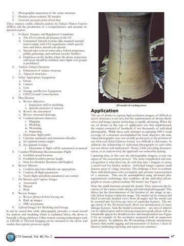
3D model of cooling tower
Application
The use of drones to capture high resolution imagery of difficult to access structures is not new, but the sophistication of drones themselves and image capture technology is rapidly advancing. When the use of drones in this type of application was first implemented, the output consisted of hundreds, if not thousands, of individual photographs. While these early attempts at capturing 100% visual coverage of a structure accomplished the basic objective, the individual photographs were not usefully geolocated, so the position of any observed defect/distress feature was difficult to determine. In addition, the relationship of individual photographs to each other was not always well understood. Hence, while providing documentation, as an analysis tool, the approach was somewhat lacking. Capturing data, in this case the photographic imagery, is just one aspect of the assessment process. The more complicated and critical question is what does one do with that data / imagery to create a useful tool for further analysis. Individual images capture small discrete areas of a large structure. The challenge is how to combine these individual pieces into a complete and accurate representation of a structure. This can be accomplished using advanced photogrammetric technology that combines all the individual photographs to create a photo-realistic 3D model. (see Figure 1) Note the small frustums around the model. They represent the locations of the camera while taking each individual photograph. This allows for the determination of the location of any image or specific defect feature within the image. The model can be rotated and tilted to provide detailed views from all angles and the model can be zoomed into for close-up views of particular features. The image clarity of the 3D model itself allows for identification of many damage features. And, the model is interactive - any area of interest can be clicked upon and its closeup inspection-grade photo will automatically appear for detailed review and interpretation (see Figure 2 for an example of the resolution associated with an inspection grade photo). In addition, the 3D modeling software incorporates features that enable tagging and measurement of defects / areas of distress, facilitating reporting and repair cost estimates. 47