

on Dutch maps and engravings of the XVI-XVIII centuries
The catalogue was developed by Caucasus Open Space (COS) within the project: "Georgia on the XVI-XVIII Century Dutch Maps and Gravures: Connectivity History" with the support by the Embassy of the Kingdom of the Netherlands in Georgia. All opinions expressed in the catalogue may not reflect official policy or views of the Embassy.

Author: Sulkhan Saladze
Responsible persons: Irma Pavliashvili, Teona Macharashvili
Design: Mariam Mutidze
Tbilisi 2022
It is prohibited to reprint, copy or distribute the catalogue or its parts for commercial purposes without express written consent by the Caucasus Open Space (COS).

სამეფოს საელჩოს ფინანსური მხარდაჭერით და მასში გამოთქმული მოსაზრებები შესაძლოა არ ასახავდეს საელჩოს ოფიციალურ პოლიტიკას ან შეხედულებებს. ავტორი: სულხან სალძე პასუხისმგებელი პირები: ირმა პავლიაშვილი, თეონა მაჭარაშვილი დიზანი/დაკაბადონება: მარიამ მუთიძე თბილისი 2022 © აკრძალულია კატალოგში მოყვანილი მასალების გადაბეჭდვა, გამრავლება და გავრცელება კომერციული მიზნით „ღია სივრცე კავკასიის“ (COS) თანხმობის გარეშე.
კატალოგი მომზადდა ა(ა)იპ ღია სივრცე კავკასიის პროექტის „საქართველო XVI-XVIII საუკუნეების ნიდერლანდურ რუკებსა და გრავიურებზე: „დაკავშირებულობის“ ისტორია“, ფარგლებში ნიდერლანდების
საქართველო
საუკუნეების ნიდერლანდურ რუკებსა და გრავიურებზე Georgia
©
XVI-XVIII

This year, 2022, we mark the 30th anniversary of the establishment of diplomatic relations between Georgia and the Kingdom of the Netherlands. The exhibition "Georgia on Dutch maps and engravings of the XVI-XVIII centuries" from the private collection of Sulkhan Saladze is dedicated to this date and is supported by the Netherlands embassy in Georgia. The exhibition will be held in Batumi, Zugdidi, Kutaisi and Tbilisi (in 2023), organized by Caucasus Open Space. The exhibition features 26 maps and engravings published in Amsterdam, Leiden and other cities. The maps illustrate that already in previous centuries, countries across the Black Sea, from Europe to Asia, were exploring new routes and looking for connectivity. This remains relevant to this day. I am therefore happy that we have the opportunity to get acquainted with these old maps, learn more about the views on the world of our ancestors and translate what we learn to the world of today.
I wish all viewers an interesting experience and look forward to also welcoming the exhibition in Tbilisi next year.
2022 წელს აღვნიშნავთ საქართველოსა და ნიდერლანდების სამეფოს შორის დიპლომატიური ურთიერთობების დამყარების 30 წლისთავს. გამოფენა „საქართველო XVI-XVIII საუკუნეების ნიდერლანდურ რუკებსა და გრავიურებზე“, სადაც სულხან სალაძის პირად კოლექციაში დაცული ექსპონატებია წარმოდგენილი, სწორედ ამ თარიღს ეძღვნება და საქართველოში ნიდერლანდების საელჩოს მიერაა მხარდაჭერილი. გამოფენა, „ღია სივრცე კავკასიის“
26 რუკა და გრავიურა. ეს რუკები გვიჩვენებს, რომ ჯერ კიდევ წინა საუკუნეებში, შავი ზღვის გაღმა-გამოღმა მდებარე ევროპის და აზიის ქვეყნები, ახალ მარშრუტებსა და კავშირებს ეძიებდნენ. ეს საკითხი დღემდე აქტუალურია. სწორედ ამიტომ, მოხარული ვარ, რომ საშუალება გვეძლვა, გავეცნოთ ამ ძველ რუკებს, შევიტყოთ მეტი იმაზე, თუ როგორ ხედავდნენ ჩვენი წინაპრები მსოფლიოს და ეს ინფორმაცია თანამედროვე სამყაროში გადმოვიტანოთ. ყველა მნახველს ვუსურვებ საინტერესო გამოცდილების მიღებას და ასევე მოუთმენლად ველი გამოფენას მომავალ წელს თბილისში. მააიკე ვან კოლდამი ნიდერლანდების სამეფოს ელჩი საქართველოში
ორგანიზებით, მოეწყობა ბათუმში, ზუგდიდში, ქუთაისსა და თბილისში (2023 წელს). გამოფენაზე წარმოდგენილია ამსტერდამში, ლეიდენსა და სხვა ქალაქებში გამოცემული
Maaike van Koldam Ambassador of the Kingdom of the Netherlands to Georgia
Golden Age of the Dutch Cartography and Georgia
ნიდერლანდური კარტოგრაფიის ოქროს საუკუნე და საქართველო
ევროპის და აზიის 8 რუკა; იმპერიების 6 რუკა; შავი ზღვის 2 რუკა; საქართველოს და კავკასიის 3 რუკა; ბიბლიური და ისტორიული თემატიკის 2 რუკა; საქართველოს და ქართველების ამსახველი 5 გრავიურა. XVI საუკუნის მეორე ნახევარი ნიდერლანდური კარტოგრაფიის ოქროს საუკუნის დასაწყისად მიიჩნევა. ამ პერიოდიდან, იტალიელ კარტოგრაფებს ნიდერლანდელებისა და ფლანდრიელების სახით, სერიოზული მეტოქეები გამოუჩდნენ. ისინი, ძირითადად, თანამედროვე ნიდერლანდების და ბელგიის ქალაქებში ცხოვრობდნენ. ოქროს საუკუნის დასაწყისი უკავშირდება ფლანდრიელი კარტოგრაფების, გერარდ მერკარტორის მიერ 1569 წელს, მსოფლიო რუკის შექმნას და აბრაჰამ ორტელიუსის მიერ, 1570 წელს, მსოფლიოს პირველი სისტემატიზებული ატლასის გამოცემას. მნიშვნელოვანი რუკები შეიქმნა შემდეგ წლებში ამსტერდამში, დუისბურგში, კელნში, ლეიდენში და სხვა ქალაქებში. ამსტერდამი გადაიქცა კარტოგრაფიის უდიდეს ცენტრად ევროპაში. აქ რუკებისა თუ სხვა გეოგრაფიული ატლასების შექმნა და გამოცემა არა ცალკეული კარტოგრაფის ან გამომცემლის საქმიანობა, არამედ, მნიშვნელოვანი საგვარეულო ბიზნესი იყო. საკმარისია მერკარტორების, დე ჯოდების, ჰონდიუსების, ბლაუების, ვიშერების, იანსონების და დანკერტსების გვარების დასახელება. ამსტერდამში საუკეთესო ევროპული რუკების ბეჭდვა არც მას შემდეგ დასრულებულა, რაც ნიდერლანდებმა XVIII საუკუნის დასაწყისიდან კარტოგრაფიაში პირველობა ევროპის სხვა ქვეყნებს დაუთმო. არაერთი ფრანგი კარტოგრაფის და მოგზაურის გახსენება შეიძლება, ვის მიერაც XVII საუკუნის ბოლოსა და XVIII საუკუნის პირველ ნახევრში შექმნილი საუკეთესო რუკები თუ გრავიურები, პარიზის პარალელურად, წარმატებით იბეჭდებოდა ამსტერდამში არსებულ უდიდეს საგამომცემლო
ამ გამოფენის მიზანია საუკუნეების განმავლობაში ნიდერლანდებში შექმნილი იმ რუკებისა და გრავიურების თავმოყრა,
უკავშირდებიან საქართველოს. მათი ნაწილი საქართველოსთან ან მის რომელიმე მხარესთანაა პირდაპირ მიმართებაში, ნაწილი კი, საქართველოს ასახავს კონტინენტების, კავკასიის რეგიონის, იმპერიებისა ან ბიბლიური თემატიკის რუკებზე. გამოფენაზე, ასევე, ფრანგი და გერმანელი კარტოგრაფებისა და გამომცემლების რუკები და გრავიურებიცაა წარმოდგენილი, თუმცა, უმეტეს შემთხვევაში, მათი ცხოვრების მნიშვნელოვანი ნაწილი ამსტერდამს უკავშირდება და გამოცემებიც იქვეა დაბეჭდილი. გამოფენაზე წარმოდგენილია საქართველოს და მასთან დაკავშირებული ცნობების ამსახველი, 6 თემატური და გეოგრაფიული კატეგორიის, 26 რუკა და გრავიურა:
სახლში.
რომლებიც
Amsterdam remained at the heart of European map-making even after the end of XVII century and beginning of the XVIII century, when other European cities emerged as powerful competitors in cartography; some of the best maps and gravures were being printed in Paris, by a number of French cartographers and travelers, parallel to their peers in Amsterdam’s largest publishing houses.
This exhibition aims to gather the maps and gravures about Georgia, which were created throughout the centuries in the Netherlands or by Dutch cartographers. Some of the maps reflect Georgia directly, others depict Georgia as part of a continent, Caucasus region, or of different empires and biblical maps. The exhibition also includes the maps and gravures of French and German cartographers and publishers, however, in most cases, substantial parts of their lives were related to the Netherlands and its publishing houses.
The exhibition covers 26 maps and gravures grouped by six major topics, related to Georgia:
·8 maps of Europe and Asia;
·6 maps of empires;
·2 maps of the Black Sea;
·3 maps of Georgia and the Caucasus;
·2 maps of biblical and historic genres;
·5 gravures depicting Georgia and/or Georgians.
16 maps and gravures are dated by XVIII century, 6 maps – XVII century and 4 – XVI century. Their largest share is published in Amsterdam, including the maps and gravures that were created in other European cities, but published in Amsterdam at the same time.
The geography of the 26 maps and gravures spans three contemporary states: the Netherlands, Belgium and Germany, and includes 6 cities: 17 items from Amsterdam, 3 from Leiden, 3 from Antwerp, 1 from Rotterdam, 1 from Duisburg and 1 from Cologne.
Naturally, it is impossible to collect all of the Dutch maps about/or containing information about Georgia. However, the maps and gravures presented in the exhibition offer substantial information about the perspectives and knowledge of Dutch cartographers about Georgia. Despite some of the mistakes in locating the cities or rivers on the maps, as well as some misspellings of the names of locations, those materials contain important historic knowledge.
16 რუკა და გრავიურა თარიღდება XVIII საუკუნით, 6 რუკა - XVII, ხოლო 4 მათგანი -XVI საუკუნით. მათი დიდი ნაწილი ამსტერდამშია გამოცემული, მათ შორის, ის რუკები და გრავიურები, რომლებიც ევროპის სხვა ქვეყნებში შეიქმნა, თუმცა გამოცემის ადგილი, სხვა ქალაქებთან ერთად, ამსტერდამიც იყო. 26 რუკისა და გრავიურის გეოგრაფია, თანამედროვე ევროპის სამი სახელმწიფოს: ნიდერლანდების, ბელგიის და გერმანიის 6 ქალაქს მოიცავს და შემდეგნაირად ნაწილდება: ამსტერდამი - 17, ლეიდენი - 3, ანტვერპენი - 3, როტერდამი - 1, დუისბურგი -1, კელნი-1. ცხადია, საქართველოს ან მასთან დაკავშირებული ცნობების ამსახველი ყველა ნიდერლანდური რუკის შეკრება თითქმის შეუძლებელია, თუმცა გამოფენაზე წარმოდგენილი რუკები და გრავიურები საკმარის ინფორმაციას გვაწვდიან იმის შესახებ, თუ როგორ ხედავდნენ ან რა იცოდნენ საქართველოზე მისგან ათასობით კილომეტრის დაშორებით მოღვაწე კარტოგრაფებმა. მიუხედავად იმისა, რომ რიგ შემთხვევებში რუკებზე დატანილი ქალაქების თუ მდინარეების ლოკალიზება მცდარია, ზოგან კი სახელწოდებებია არასწორად აღნიშნული, ისინი მნიშვნელოვან ისტორიულ დატვირთვას ატარებენ. გამოფენაზე წარმოდგენილია სამი რუკა, რომელთა ავტორებს ნიდერლანდური კარტოგრაფიის ოქროს საუკუნის დასაწყისი უკავშირდება. კერძოდ, ფლანდრიელი კარტოგრაფების, გერარდ მერკატორის 1578 წლით დათარიღებული “ASIAE III TAB:” (აზია III ტაბულა) და აბრაჰამ ორტელიუსის ორი რუკა: 1590 წლის “Pontus Evxinvs” (სტუმართმოყვარე ზღვა) და 1624 წელს გამოცემული „Lumen Historiarum per Orrientem (ისტორიის შუქი აღმოსავლეთში). ორივე ავტორი არამარტო ნიდერლანდური,
კარტოგრაფიის ლეგენდებად მიიჩნევიან. ევროპისა და აზიის შესაყარზე მდებარე საქართველო ბევრ რუკაზეა ასახული. ქვეყნის გეოგრაფიული მდებარეობის განსაკუთრებულობად უნდა მივიჩნიოთ ის, რომ საქართველო წარმოდგენილია როგორც აზიის, ისე ევროპის რუკებზე. ევროპის რუკებზე საქართველოსთან დაკავშირებული აღნიშნვები ყოველთვის მარჯვენა ქვედა კუთხეშია მოთავსებული, ხოლო აზიის რუკებზე, პირიქით - მარცხენა კუთხეში. მაგ.: 1592 წელს, კელნში, ნიდერლანდელ კარტოგრაფ მატიას ქუადის მიერ გამოცემული „Evropa“ (ევროპა). საუკუნეების განმავლობაში ნიდერლანდელი კარტოგრაფები რუკებზე წარმატებით უხამებდნენ ერთმანეთს ცნობებს ძველი ბიბლიური, ანტიკური და მათი თანადროული სამყაროს შესახებ. მაგ.: 1704 წელს, როტერდამში გამოცემულ დანიელ სტოპენდალის ცნობილ რუკაზე, სადაც მთავარი ფოკუსი პავლე მოციქულის მოგზაურობას უკავშირდება, რუკის მარჯვენა ზედა კუთხეში წარმოდგენილია ცნობები უძველესი ქართული სახელმწიფოების - კოლხეთისა და იბერიის შესახებ. ოღონდ, იმ განსხვავებით, რომ ძველი კოლხეთისა და იბერიის გვერდით აღნიშნულია აფხაზეთში, თანამედროვე გაგრის მახლობლად არსებული, გენუელების სავაჭრო ფაქტორია - S. Sopia (სანტა სოფია).
არამედ მსოფლიო
The exhibition includes three maps, authored during the beginning of the Golden Age of the Dutch cartography. For example, the maps by Flemish cartographers: “ASIAE III TAB:” created in 1578 by Gerard Mercator and two maps by Abraham Ortelius: “Pontus Evxinvs” (“hospitable sea”) published in 1590 and “Lumen Historiarum per Orrientem” (“light of history in the East”) published in 1624. Both authors are considered to be the legends of not only Dutch, but also world cartography.
Georgia, located at the crossroads of Europe and Asia, is depicted on many maps. The peculiarity of Georgia’s geographic location is reflected in the fact that the country is depicted on the maps of both Asia, as well as Europe. On the European maps, the markings about Georgia are reflected in right lower corner, while on the maps of Asia, on the contrary – in the left corner; for example, on the map “Evropa” (“Europe”), published in 1592 in Cologne, by Dutch cartographer Matthias Quad.
For centuries, Dutch cartographers successfully combined information from old biblical, antique as well as contemporary sources, for example, on the famous map published in 1704 Rotterdam by Daniel Stoopendaal, the focus is on the travels of the apostle Paul. The upper right corner of the map provides information about the ancient Georgian kingdoms of Kolkheti (Colchis) and Iberia, with one difference – in Abkhazia, nearby contemporary Gagra, there is indication S. Sopia (Santa Sophia) – the Genoese trade port.
The exhibition also depicts the maps, where cartographers indicate local names of the Black Sea, related to Kolkheti/Colchis kingdom –such as “Kolkheti/Colchis Sea” or “Phasis Sea”. Such names are indicated on both maps of Abraham Ortelius and the map published in 1652 Amsterdam, by Nicolaus Blankaart and Johannes Janssonius. This indicates the particular role of the Black Sea in the life of old Kolkheti/Colchis, as well as the reaffirmation that historically, the Black Sea connected, rather than divided Georgia with Europe. The Black Sea offers tremendous opportunities for Georgia and materializing this opportunity, considering current geopolitical situation, is becoming increasingly important.
The maps, themed around the golden fleece, continue the topic of old Kolkheti/Colchis. For example, the map by Henri Abraham Chatelain, published in 1719 Amsterdam, depicting the route of the Argonaut boat, heading towards Kolkheti/Colchis.
Old Dutch maps are one of the best sources to illustrate how Europeans saw Georgia, sandwiched between the interests of the two great empires – the Ottoman and the Persian. Often, the West and East Georgia is colored in different hues on the maps, or otherwise lined to reflect the overlap of those interests. However, even the maps of the empires, where Georgia is divided into small kingdoms, cartographers use unifying name “GEORGIA”, referring to entire territory. Such approach of old cartographers reflects perception of Georgian kingdoms as one unity, one country and common cultural space. Two maps of the exhibition illustrate this well: the map by Justus Danckerts, printed in 1688 Amsterdam and the map by Pieter van der Aa printed in 1713 Leiden. It must also be emphasized that the tendency of removing the name “GEORGIA” from the maps emerged much later, from the XIX century, as a phenomena related to the Russian empire. Following the annexation of the Georgia’s kingdoms, the name “GEORGIA” was substituted by “Tiflisskaya and Kutaisskaia gubernya/governorships of Tbilisi and Kutaisi”.
The map of the Caspian Sea neighborhood - “Carte Des Pays Voisins De La Mer Caspienne”, published in 1732 Amsterdam, by one of the greatest publishing houses “Covens & Mortier” deserves a special attention: Georgian diplomat and traveler Sulkhan-Saba Orbeliani participated in its making. The upper right side of the map reads: Sofkam Sabas Prince de Geoorgie (Sulkhan Saba, Georgian Lord). Although, in this case, the author of the map is the French cartographer Guillaume Delisle, and the first publication of the map was made in 1723 Paris, but the Amsterdam publication reflects the work of Sulkhan Saba with a high precision. Considering the greatness of reputation attributed to the cartographer Guillaume Delisle and the Amsterdam-based publishing house “Covens & Mortier” it is easy to imagine the scale of distribution of the information about Georgian diplomat and traveler, for people interested in cartography and the world.
The history of XVI-XVIII Dutch and overall, European cartography demonstrates that unlike the maps of Georgia or Caucasus, the maps of Georgia’s separate units or regions is rare. From this perspective, there is a pleasant exception - namely, the map of Samegrelo, printed in Leiden, in 1713 by Pieter van der Aa. The original version of the map is connected to the Catholic missionaries in the XVII Georgia – Cristoforo de Castelli and Arcangelo Lamberti. However, the Leiden publication is distinguished with the decorative elements, characteristic for Pieter van der Aa. The exhibition features the colored version of this map.
Along with the maps, the exhibition will present the gravures related to Georgia, printed in XVII-XVIII centuries in Amsterdam and Antwerp, including the distinguished gravure of the oldest sketch of Tbilisi, first created in 1673 during travels of Jean-Chardin, printed in Antwerp in 1687. Another distinguished gravure included in the exhibition depicts Tbilisian women, printed in 1737 in Amsterdam, sketched by French artist, Claude Aubriet.
იოლი წარმოსადგენია, კარტოგრაფიის და ზოგადად მსოფლიოს შესწავლით დაინტერესებული რამდენი ადამიანი გაიგებდა ქართველი დიპლომატის და მოგზაურის შესახებ. XVI-XVIII საუკუნეების ნიდერლანდური
წარმოადგენს საქართველოს ცალკეული სამეფოსამთავროების და რეგიონების რუკები. ამ მხრივ სასიამოვნო გამონაკლისია, ლეიდენში, 1713 წელს პიტერ ვან დერ აას მიერ გამოცემული სამეგრელოს რუკა. ამ რუკის თავადაპირველი ვერსია, XVII საუკუნეში საქართველოში მოღვაწე კათოლიკე მისიონერების - კრისტოფორო კასტელის და არქანჯელო ლამბერტის სახელს უკავშირდება. თუმცა, ლეიდენური გამოცემა ვან დერ აასთვის დამახასიათებელი გაფორმებებით გამოირჩევა. გამოფენაზე წარმოდგენილია რუკის ფერადი ვერსია. რუკებთან ერთად, გამოფენაზე ნახავთ XVII-XVIII საუკუნეებში, ამსტერდამსა და ანტვერპენში დაბეჭდილ საქართველოსთან დაკავშირებულ გრავიურებს. აუცილებლად უნდა ვახსენოთ, 1687 წელს, ანტვერპენში დაბეჭდილი თბილისის უძველესი ჩანახატის გრავიურა, რომელიც 1673 წელს, ფრანგ მოგზაურ ჟან შარდენის საქართველოში ყოფნის დროს შეიქმნა და 1737 წელს, ამსტერდამში დაბეჭდილი თბილისელი ქალების ჩანახატი, რომლის ავტორია ფრანგი მხატვარი კლოდ ობრიე.
და მთლიანად ევროპული კარტოგრაფიის ისტორია მოწმობს, რომ განსხვავებით საქართველოს ან კავკასიის თემატიკაზე მომზადებული რუკებისგან, იშვიათობას

Maps and Gravures
რუკები და გრავიურები
კოლხეთის სამეფოდან PONTI EVXINI PARS-ს (შავი ზღვა) არაერთი მდინარე უერთდება. მათ შორის, Apsorrus flu (ჭოროხი), Phasis flu (რიონი), Hippus flu (ცხენისწყალი), Cianeus flu (ჭანისწყალი), Corax fluuius (კოდორი) რუკაზე ნათლად ჩანს, რომ მდინარე რიონის დინება შეცდომით, სამხრეთიდან - ჩრდილო-დასავლეთით არის მიმართული, მაშინ, როდესაც ის ჩრდილოეთიდან - სამხრეთ-დასავლეთით უნდა მიედინებოდეს კარგად იკითხება კოლხური ტომების - Manrali (მეგრელები) და Zani (ჭანების) განსახლების ადგილები ციხე-ქალაქებიდან აღნიშნულია: Apsorrus (გონიო), Sebastopolis (სავარაუდოდ, ციხისძირი), Phasis (ფაზისი), Aiapolis (აია), Dioscuria, Sebastopolis (სოხუმი) და სხვ. კოლხეთის სამეფოდან სამხრეთით, ვერტიკალურად გამოსახულ მთებზე,
Gerard Mercator (1512-1594)
Asiae III Tab Duisburg 1579 68x59
The map is created by Gerard Mercator, based on Ptolemy’s Geography
The hand-colored map depicts the countries located between the Black and Caspian Seas. The map accentuates Colchis, Iberia, Albania, and Kingdom of Armenia. Major cities, rivers, lakes, mountains, and passes are indicated. The map includes decorative elements in the Caspian Sea, as well as the beast in the area of the Black Sea
The map depicts Georgian Kingdoms – Colchis and Iberia. Kingdom of Colchis connects to the Ponti Evxini Pars (the Black Sea) through several rivers, among others: Apsorrus flu (contemporary Chorokhi), Phasis flu (Rioni), Hippus flu (Tskhenistskali), Cianeus flu (Chanistskali), Corax fluuius (Kodori) The map mistakenly locates the flow of Rioni river from South through North-West, while, it flows from North towards South-West
The map also shows the settlements of the Manrali (Megreli) and Zani (Chani) tribes
Castle-towns indicated on the map include: Apsorrus (Gonio), Sebastopolis (likely, Tsikhisdziri), Phasis, Aiapolis (Aya), Dioscuria, Sebastopolis (Sokhumi) and others
South of Kolkheti/Colchis kingdom, Moschichi montes (Meskhetian mountains) are indicated on vertically drawn mountains, which continue towards South-West ending in Trapezus (Trapzoni). North of Kolkheti/Colchis kingdom, in the direction of Iberia, Caucasus mons (Caucasus Mountains) are stretching horizontally
The map indicates Zalissa (Dzalisa), Armactica (Armazi Castle), Mestleta (Mtskheta), Sura (likely Surami), Artanissa (Artanuji) and others, in the area of Iberia
The map also indicates Cyrus fluuius (Mtkvari) river, however, its flow is indicated incorrectly as well – the map indicates the flow from the North to the South vertically, because of which Surami and Artanuji appear to the North of Mtskheta.
გერარდ მერკარტორი (1512-1594) ტაბულა აზია III დუისბურგი 1579 წ 68x59 რუკა მომზადებულია გერარდ მერკარტორის მიერ, პტოლემეს გეოგრაფიის საფუძველზე. ხელით გაფერადებულ რუკაზე დატანილია შავ და კასპიის ზღვებს შორის
ტბები, მთები და უღელტეხილები. რუკას თან ერთვის კასპიის ზღვაში ჩახატული რუკის დეკორატიული გაფორმება და შავ ზღვაში დახატული ურჩხული რუკაზე კარგად იკითხება ძველი ქართული სამეფოები - კოლხეთი და იბერია
აღნიშნულია Moschichi montes (მესხეთის მთები), რომელიც სამხრეთ დასავლეთით გრძელდება და Trapezus-თან (ტრაპიზონი) მთავრდება კოლხეთის სამეფოს ჩრდილოეთიდან, იბერიის მიმართულებით, ჰორიზონტალურად მიუყვება Caucasus mons (კავკასიონის მთები) იბერიის ნაწილში რუკაზე აღნიშნულია: Zalissa ( ძალისა), Armactica (არმაზის ციხე), Mestleta (მცხეთა), Sura (სავარაუდოდ, სურამი), Artanissa (არტანუჯი) და სხვ. მდინარეებიდან, ასევე, აღნიშნულია Cyrus fluuius (მტკვარი),
ვერტიკალურად სამხრეთით არის გამოსახული. დინების მცდარი აღნიშნვის გამო, რუკაზე სურამი და არტანუჯი, მცხეთიდან ჩრდილოეთით ექცევა
მოქცეული ქვეყნები. რუკის ფოკუსი მიმართულია COLCHIS-ის (კოლხეთი), IBERIA-ს (იბერია), ALBANIA-ს (ალბანეთი) და ARMENIA MAIOR-ისკენ (სომხეთი) აღნიშნულია მთავარი ქალაქები, მდინარეები,
თუმცა მისი დინება არასწორად, ჩრდილოეთიდან


მათიას ქუადი (1557-1613) ევროპა კელნი 1592 წ 37x25 მატიას ქუადის ევროპის რუკის ამ
გამოცემაზე, რომელიც გამოცემის მერე გაფერადდა, მთავარი ფოკუსი მიმართულია ევროპის კონტინენტისკენ და მიუხედავად რუკის მცირე ზომისა, დეტალურად არის წარმოჩენილი კარტოგრაფის თვალით დანახული ევროპა
PONTVS EVXINVS (შავი ზღვის) აღმოსავლეთ სანაპიროზე წარმოდგენილია საქართველოს ქალაქები და ციხეები: Gonca (გონიო), Zonati (ბათუმი), Fasso (ფაზისი), Zauatopoli (სოხუმი) და Goro (სავარაუდოდ, გაგრა). გონიოს ქვემოთ დატანილია წარწერა “QUIXA”, რაც, შესაძლოა, გურიას აღნიშნავდეს რუკაზე არ არის აღნიშნული თბილისი და საქართველოს აღმოსავლეთ ნაწილში მდებარე სხვა
Matthias Quad (1557-1613) Evropa Cologne 1592 წ 37x25
This German publication of the Europe’s map by Matthias Quad, colored after publication, focuses mainly on European continent and despite the small size of the map, provides detailed depictions of the Europe, seen through the eyes of the cartographer
The Eastern shore of PONTVS EVXINVS (Black Sea) depicts Gonca (Gonio), Zonati (Batumi), Phasis, Zauatopoli (Sokhumi) and Goro (likely, Gagra) QUIXA is indicated below Gonio, which, likely, indicates Guria. The map does not indicate Tbilisi, nor other cities of Eastern Georgia, however, the indication “GEORGIANI” is prominent, indicating Georgia, or the country of Georgians.
გერმანულენოვან
ქალაქები,
კარგად იკითხება წარწერა - „GEORGIANI”, რაც საქართველოს, ქართველების ქვეყანას აღნიშნავს
თუმცა,

Abraham Ortelius (1527-1598), Balthasar Moretus (1574-1641)
Lumen Historiarum per Orrientem Antwerpen. 1595/1624 62x52
The map brings together the imagined old Biblical world and the contemporary knowledge by Abraham Ortelius. The 1624 publication, included in the Parergon atlas by Balthasar Moretus, is considered the best edition of this map.
The core focus of the map is dedicated to the biblical themes: Jerusalem is depicted in detail, as well as old Egypt, Mesopotamia, and other locations. The main map includes two smaller framed maps, of which one depicts Jerusalem and its surroundings and the other – the contemporary version of the world, including the discoveries – including those of Christopher Columbus.
(კასპიის
ნაპირებთან შავი ზღვის აღსანიშნავად გამოყენებულია წარწერა „Phasianum Mare” (ფაზისის ზღვა). ძველი კოლხეთის ნაპირებთან შავი ზღვის ამ სახელწოდებას ორტელიუსის კიდევ ერთ, 1590 წლის „PONTVS EUXINVS“-ის (სტუმართმოყვარე ზღვა) რუკაზეც ვხდებით. ორ სხვადასხვა რუკაზე, შავი ზღვის აღმოსავლეთ სანაპიროსთან, იქ, სადაც კოლხეთი იყო, შავი ზღვის აღსანიშნავად ფაზისის ზღვის გამოყენება, კოლხების ცხოვრებაში ზღვის განსაკუთრებული მნიშვნელობის დამასტურებელ ცნობად შეიძლება მივიჩნიოთ. რუკაზე კარგად იკითხება COLCHIS (კოლხეთი) და IBERIA (იბერია). ორჯერ არის აღნიშნული ფაზისი. ერთ შემთხვევაში წარწერა Phasis ქალაქის აღსანიშნავად არის გამოყენებული, ხოლო, მეორე შემთხვევაში - Phasis flu - თანამედროვე მდინარე რიონია. საქართველოს
The information about Georgia is indicated in the center of the map – PONTVS EVXSINVS & AXENUS (hospitable and unhospitable sea) – referring to the territory between the Black Sea and MARE CASPIVM (Caspian Sea). The Black Sea at the shores of Georgia indicates “Phasianum Mare” (Phasis Sea). This name of the Black Sea at the shores of old Kolkheti/Colchis is indicated on one more map by Ortelius – the PONTVS EUXINVS (hospitable sea) published in 1590. Usage of the name “Phasis Sea” for the Black Sea at the shores of Kolkheti/Colchis indicates a special role of the sea in the life of the Kolkhetian/Colchis people.
The map reads COLCHIS and IBERIA, with Phasis indicated twice. In one case, Phasis indicates the city, in another case – Phasis flu – indicates the river Rioni. One more Georgian river – Aragvi flu is included in the map as well, which had an important role for the kingdom of Iberia.
Considering that this work of Ortelius is a combination of the old biblical sources and the information from the late XVI century, the map indicates the word GEORGIANI, meaning –Georgians.
It is possible that another indication on the map may be related to Georgia. Specifically, on the territory of contemporary Israel, there is indication GEORGIA, which, possibly, could indicate the Georgian church-monastery located there.
A short vocabulary, made with Latin alphabet, is the distinguishing feature of the map. The vocabulary frames the text from the three sides. The letter “I” is marked with the word “IBERI” (Iberia) and it is indicated that Iberians (or Georgians) are the people living between the Black and the Caspian seas.
ქართველები, არიან შავ და კასპიის ზღვებს შორის მოსახლე ხალხი.
ბიბლიური და აბრაჰამ ორტელიუსის
სამყარო. 1624 წლის გამოცემა, რომელიც ბალთაზარ მორეტუსმა პარეგონის ატლასში შეიტანა, ამ რუკის საუკეთესო გამოცემად მიიჩნევა. რუკის ძირითადი ფოკუსი ბიბლიურ თემატიკას ეთმობა: დეტალურადაა წარმოდგენილი იერუსალმი, ძველი ეგვიპტე, შუამდინარეთი და სხვა ადგილები. მთავარ რუკას თან ახლავს ჩარჩოში ჩასმული ორი პატარა რუკა. ერთზე იერუსალიმი და მიმდებარე ტერიტორიებია, ხოლო მეორეზე - რუკის გამოცემის დროისათვის ცნობილი მსოფლიო. მათ შორის, ქრისტეფორე კოლუმბთან დაკავშირებული აღმოჩენები. ცნობები საქართველოს შესახებ დატანილია რუკის ცენტრში, PONTVS EVXINVS & AXENUS (სტუმართმოყვარე და არასტუმართმოყვარე ზღვა) ანუ იგივე შავი ზღვის და
მდინარეებიდან რუკაზე კიდევ ერთი მდინარე - Aragvi flu (არაგვი) არის დატანილი, რომელიც იბერიის სამეფოს უმნიშვნელოვანესი მდინარე იყო. იმის გათვალისწინებით, რომ ორტელიუსის ეს ნამუშევარი, ძველი ბიბლიური და XVI საუკუნის ბოლოს სამყაროს ერთგვარი ნაზავია, რუკაზე ვხდებით წარწერას - GEORGIANI, ანუ, ქართველები. შესაძლოა რუკაზე საქართველოსთან იყოს დაკავშირებული კიდევ ერთი აღნიშვნა. კერძოდ, თანამედროვე ისრაელის ადგილას, ვხდებით წარწერას GEORGIA, რაც, შესაძლოა, იქ არსებულ ქართულ ეკლესია-მონასტერს აღნიშნავდეს. რუკას განსაკუთრებულ მნიშვნელობას მატებს ლათინური ალფაბეტის მიხედვით შედგენილი მცირე ლექსიკონი, რომელიც ტექსტის სახით სამი მხრიდან ერტყმის. ასო-ბგერა „I” - “IBERI”ით (იბერია) იწყება და აღნიშნულია, რომ იბერიელები, ანუ
აბრაჰამ ორტელიუსი (1527-1598), ბალთაზარ მორეტუსი (1574-1641) ისტორიის შუქი აღმოსავლეთში ანტვერპენი. 1595/1624 წ. 62x52 რუკაზე, ერთდროულადაა წარმოდგენილი ძველი
თანამედროვე
MARE CASPIVM-ს
ზღვა) შორის მოქცეულ ტერიტორიაზე. საქართველოს

იოჰანეს იანსონიუსი (1588-1664), ნიკოლას ბლანკაარტი (დაახლ. 1624-1703) ძველი აზია, აფრიკის და აზიის მეზობელი რეგიონებით ამსტერდამი 1652 წ 70x56 რუკაზე დატანილი
Johannes Janssonius (1588-1664), Nicolaus Blankaart (approx. 1624-1703) Asia Antiqua cum finitimis Africae et Europae Regionibus Amsterdam 1652 70x56
The information, indicated on the map includes the continent of Asia, as well as the Eastern part of Europe and the North-Eastern part of African continent.
The map indicates information about old Asia. Therefore, the maps of Janssonius and Blankaart do not provide information from their contemporaries.
კოლხეთსა და იბერიას უკავშირდება, ხოლო მეორე, შავი ზღვის ერთ-ერთ სახელწოდებას. რუკაზე შავი ზღვის მთავარი სახელწოდების: PONTUS EUXINUS (სტუმართმოყვარე ზღვა) გვერდით, ზღვის არაერთი სახელია დატანილი. მათ შორის არის ზღვის საქართველოსთან დაკავშირებული სახელწოდება - Colchicum (კოლხეთი ზღვა), რასაც მოსდევს Caucaseum (კავკასიის ზღვა) კოლხეთის და კავკასიის ზღვების აღსანიშნავად რუკაზე წყაროდ მითითებულია სტრაბონი და აპოლონიოსი (სავარაუდოდ, კარტოგრაფი აქ აპოლონიოს როდოსელს უნდა გულისხმობდეს). შავ და კასპიის ზღვებს შორის მოქცეულია COLCHIS (კოლხეთი) და IBERIA (იბერია). კოლხეთის შემთხვევაში რუკაზე შეაძლებელია: Apssoru (გონიო), Phasis (ფაზისი), Aeapolis (აია) და Dioscurias quce Sebastopolis (სოხუმი) იდენტიფიცირება. მდინარეებიდან - მდინარე რიონის (Phasis fl.),
The map of Georgia includes two important indications. First one depicts old Georgian kingdoms, Kolkheti/Colchis and Iberia, while the other includes one of the names of the Black Sea - PONTUS EUXINUS (hospitable sea) Another name of the sea is connected to Georgia – Colchicum (Colchis sea) followed by Caucaseum (Caucasus sea). The indications of Colchis and Caucasus seas are traced back to Strabo and Apollonius (most likely, cartographer meant to indicate Apollonius Rhodes).
COLCHIS (Kolkheti) and IBERIA are sandwiched between the Black and the Caspian seas. In case of Colchis, the map includes Abssoru (Gonio), Phasis, Aeapolis (Aya) and Dioscurias quce Sebastopolis (Sokhumi). Phasis fl. (Rioni) is indicated as well, however, its flow is marked incorrectly - from South towards North-West
In case of Iberia, the map includes Artanisa (Artanuji), Sura (likely, Surami) and Armactica (Armazi). Also, the map includes Cyrus fl. (Mtkvari). However, due to incorrect indication of the flow of the river, the locations of Artanuji and Surami look misplaced.
From the North, Iberia is bordered by Caucasus mons (Caucasus Mountain range), where the door is drawn in the mountain turns – or Dariali pass.
ინფორმაცია მოიცავს, როგორც საკუთრივ აზიის კონტინენტს, ისე ევროპის აღმოსავლეთ ნაწილს და აფრიკის კონტინენტის ჩრდილო-აღმოსავლეთ ნაწილს რუკაზე წარმოდგენილია ცნობები ძველი აზიის შესახებ. შესაბამისად, იანსონიუსის და ბლანკაარტის რუკაზე არ ვხდებით მათი მოღვაწეობის ეპოქის შესაბამის ცნობებს საქართველოს შესახებ რუკაზე ორი მნიშვნელოვანი აღნიშვნაა პირველი საკუთრივ უძველეს ქართულ სახელმწიფოებს,
არის მიმართული იბერიის შემთხვევაში რუკაზე იკითხება: Artanisa (არტანუჯი), Sura (სავარაუდოდ, სურამი) და Armactica (არმაზი) ასევე, მდინარე Cyrus fl (მტკვარი) თუმცა, იმის გამო, რომ მდინარე მტკვრის დინება, შეცდომით, ჩრდილოეთიდან სამხრეთ აღმოსავლეთის მიმართულებით არის ნაჩვენები, არტანუჯის და სურამის მდებარეობა შეუსაბამოდ გამოიყურება იბერიას ჩრდილოეთიდან საზღვრავს Caucasus mons (კავკასიონის მთათა სისტემა), სადაც შესაძლებელია მთაგრეხილებში ჩახატული კარის, იგივე დარიალის გასასვლელის, ამოცნობა.
რომლის დინებაც შეცდომით, სამხრეთიდან ჩრდილო-დასავლეთისკენ

ფრედერიკ დე ვიტის სხვა რუკების მსგავსად, ევროპის რუკაც უხვადა არის გაფორმებული: ანგელოზები, ზევსის მიერ ევროპეს მოტაცების სცენა, ურჩხული და გემები. საქართველოსთან დაკავშირებული ცნობები წარმოდგენილია შავი ზღვის აღმოსავლეთ სანაპიროზე. თუმცა, არ არის დატანილი საქართველოს აღმნიშვნელი წარწერა კარგად იკითხება შედეგი ქალაქები და დასახლებები: Lonati (ბათუმი), Phasis (ფაზისი), Tamensi (ტამიში), Savatopoli (სოხუმი), Pezonda (ბიჭვინთა), Chiutates (ქუთაისი), Cori (გორი) და სხვ მდინარებიდან აღიშნულია Phasis flu (რიონი) რომელზეც მრავლად არის დატანილი ხიდები თუმცა,
Frederick De Wit (approx. 1629-1706) Nova et Accurata totius Europae Descriptio Amsterdam 1680 65x55
The key focus of the map is directed towards the continent of Europe Traditionally, similar to other maps by Frederick De Wit, the map of Europe is decorated in abundance, depicting angels, scene of kidnapping of Evropa by Zeuss, a monster and the ships.
Information about Georgia is presented in the Eastern coast of the Black Sea However, there is no toponymic of Georgia indicated. The following cities however are well readable: Lonati (Batumi), Phasis, Tamensi (Tamishi), Sevatopoli (Sokhumi), Pezonda (Bichvinta), Chiutates (Kutaisi), Cori (Gori) and others
Following rivers are also indicated – Phasis flu (Rioni), which depicts multiple bridges However, the map of De Wit, just like those of his predecessors, depicts incorrect direction of the Mtkvari river flow.
ფრედერიკ დე ვიტი (დაახ.1629-1706) ევროპის ახალი და სრული აღწერა ამსტერდამი 1680 65x55 რუკის მთავარი ფოკუსი მიმართულია ევროპის კონტინენტზე. ტრადიციულად,
დე ვიტის რუკაზე, ისევე როგორც მისი ბევრი წინამორბედი კარტოგრაფის შემთხვევაში, მდინარე რიონის დინების მიმართულება არასწორადაა აღნიშნული.

ფილიპ კლუვერი (1580 -1622), პიტერ ბერტიუსი (1565 -1629) სპარსეთი ადამ ოლეარიუსისაგან ამსტერდამი. 1686 წ. 17x16 რუკის მთავარი აქცენტი მიმართულია სპარსეთზე თუმცა რუკის უკიდურეს მარჯვენა ზედა კუთხეში, PONTUS EUXINUS-ს (შავი ზღვა) და MARE CASPIUM-ს (კასპიის ზღვა) შორის, საქართველოსთან დაკავშირებული რამდენიმე საინტერესო მინაწერი იკითხება. კერძოდ, Colchis (კოლხეთი), Tiflis (თბილისი) და Caucasus mons (კავკასიონის მთათა სისტემა). ასევე, შესაძლოა, კოლხეთის აღმნიშვნელი წარწერიდან ჩრდილოეთით რუკაზე დატანილი “Bantina”, ბათუმს წარმოადგენდეს.
Philipp Cluver (1580 -1622), Peter Bertius (1565 -1629)
Persia ex Adamo Oleario Amsterdam. 1686 17x16
The key accent of the map is directed towards Persia However, in the upper right corner of the map, between PONTUS EUXINUS (Black Sea) and MARE CASPIUM (Caspian Sea) there is a number of interesting indications related to Georgia, namely –Colchis (Kolkheti), Tiflis (Tbilisi) and Caucasus mons (Caucasus mountain range) Also, it is highly possible that “Bantina” indicated farther Northward could in fact be Batumi.

შარდენი (1643-1713), გიიომ ჟოზეფ გრელო (დაახლ. 1630-1680)
შარდენის მოგზაურობის დღიური სპარსეთსა და აღმოსავლეთ ინდოეთში, შავი ზღვის და კოლხეთის გავლით ამსტერდამი. 1687 წ. 17x22 ჟან შარდენის მოგზაურობის ამსახველ მრავალ გამოცემათა შორის, 1687 წელს, ამსტერდამში დაბეჭდილი ეს ვერსია, სატიტულო გვერდზე კოლხი (მარჯვნივ) და სპარსი (მარცხნივ) მამაკაცების გრავიურით გამოირჩევა. კოლხი მამაკაცის გამოსახულების ქვემოთ იკითხება წარწერა: „კოლხი მიდის თოვლზე“ (Kolcher gaande over de sneeuw) გრავიურის სიღრმეში მეჩეთები და ქალაქის სხვა დეტალები ჩანს, მათ ზღვა და გემები მოსდევს. თუმცა, აქ სპარსეთის რომელიმე საზღვაო ქალაქი უნდა იგულისხმებოდეს და არა შავი ზღვის საქართველოს ნაპირი. გრავიურაზე წარმოდგენილი კოლხი იგივე მეგრელი მამაკაცია. არსებობს ამ მამაკაცის გრავიურის სხვა ვერსიაც, სადაც იგი მარტოა წარმოდგენილი თხილამურებით თოვლში გრავიურა
Jean Chardin (1643-1713), Guillaume-Joseph Grelot (approx. 1630-1680)
Dagverhaal der reis van den ridder chardyn na persien een oost - Indian, door de Swarte zee en colchis Amsterdam. 1687 17x22
Among many publications, depicting Jean Chardin’s travels, this version printed in 1687 Amsterdam is distinguished by its title page, depicting gravures of Kolkhetian/Colchis man (to the right) and Persian man (to the left). The writing above the Colchis man says, “Colchis man walking on snow” (Kolcher gaande over de sneeuw)
Background of the gravure depicts mosques and other details of the city, followed by the sea and the ships However, this is probably the reference to one of the seaside cities of Persia, rather than Georgia’s coast on the Black Sea.
The Kolkhetian/Colchis man depicted on the gravure is the same Megrelian man There are other versions of this gravure, where he is standing alone, wearing skis in the snow.
The gravure is likely colored upon printing
ბეჭდვის შემდგომ, თანადროულად უნდა იყოს გაფერადებული
ჟან
ჟან

თანამედროვე ევროპის, აზიის და აფრიკის კონტინენტზე ნაწილდება. რუკაზე მნიშვნელოვანი ინფორმაციაა დატანილი PONTUS EUXINUS-ს (შავი ზღვა) და MARE DE SALA CASPIUM-ს (კასპიის ზღვა) შორის მოქცეული ქვეყნების შესახებ რუკის ამ ნაწილში, კარტოგრაფის მთავარი ფოკუსი მიმართულია საქართველოზე, რომლის საერთო აღმნიშვნელად იყენებს სახელწოდებას „GEORGIENS”. ეს წარწერა სრულად ფარავს საქართველოს ჰორიზონტალურად, შავი ზღვიდან - კასპიის ზღვის მიმართულებით. რუკაზე კარგად იკითხება საქართველოს სამეფო-სამთავროების და მხარეების შესახებ გაკეთებული წარწერები: ODISCI (ოდიში), MINGRELI (სამეგრელო), IMERETI (იმერეთი), GURIEL (გურია), CARDUEL (ქართლი), ZACHETI (კახეთი) და BARATRALU (სავარაუდოდ, სამცხე) დანკერტსის რუკაზე, ვრცლად არის წარმოდგენილი საქართველოს
Justus Danckerts (1635-1701)
Accuratissima et Maxima Totius Turcici Imperii Tabula Amsterdam 1688 45x37
The map of Danckerts is entirely dedicated to the Ottoman Empire and covers a large territory, spanning contemporary Europe, Asia and African continents.
The map includes important information – PONTUS EUXINUS (Black Sea) and MARE DE SALA CASPIUM (Caspian Sea), and the countries located between them. This part of the map mainly focuses on Georgia, describing it as GEORGIENS This indication completely covers Georgia horizontally from the Black Sea towards the Caspian Sea
The map offers thorough depiction of the Georgian kingdoms and regions: ODISCI (Odishi), MINGRELI (Samegrelo), IMERETI (Imereti), GURIEL (Guria), CARDUEL (Kartli), ZACHETI (Kakheti), and BARATRALU (likely, Samtskhe).
The map of Danckerts provides detailed information about the coastal line of Georgia as well: Varthi (Batumi), Fasso (Phasis), Copus (Khobi), Anargia (Anaklia), Sauatopoli (Sokhumi) The map also indicates Cotatis (Kutaisi), Scondidi (Skanda), Teflis (Tbilisi), Zagan (Dzegami) and others. The signs used to indicate these toponymics show that compared to other cities, Phasis, Kutaisi, Tbilisi and Dzegami must have been most advanced at the time.
იუსტუს დანკერტსი (1635-1701) მთელი თურქული იმპერიის უზუსტესი და უდიდესი რუკა ამსტერდამი 1688 წ 45x37 დანკერტსის რუკა მთლიანად ოსმალეთის იმპერიას უკავშირდება და მოიცავს ვრცელ ტერიტორიას, რომელიც
Sauatopoli (სოხუმი). რუკაზე ასევე აღნიშნულია: Cotatis (ქუთაისი), Scondidi (სკანდა), Teflis (თბილისი), Zagan (ძეგამი) და სხვ ქალაქების და დასახლების აღნიშვნის მიზნით გამოყენებული ნიშნები მოწმობს, რომ სხვა ქალაქებთან შედარებით, ფაზისი, ქუთაისი, თბილისი და ძეგამი ბევრად უფრო დაწინაურებული ქალაქები უნდა ყოფილიყვნენ.
სანაპირო ზოლი: Varthi (ბათუმი), Fasso (ფაზისი), Copus (ხობი), Anargia (ანაკლია),

დაკავშირებით, წიგნში ცალკე გრავიურა ეთმობა თბილისს, რომელიც ფრანგი ჟან შარდენის მოგზაურობის შედეგად შექმნილი თბილისის პირველი გრაფიკული ჩანახატის მიხედვით არის შექმნილი და მცირედი დეტალებით განსხვავდება, 1686 წელს, ლონდონში, მოზეს პიტის მიერ გამოცემული შარდენის მოგზაურობის თბილისის ჩანახატის ვერსიისგან. თბილისის ხედის გრავიურას თან ახლავს მინაწერები, რისი წყალობითაც შესაძლებელია, ჩანახატზე კონკრეტული შენობა-ნაგებობების და ადგილების იდენტიფიცირება. კერძოდ, ლათნური ანბანის მიხედვით აღნიშნულია: A ნარიყალას ციხე;; B სიონი; C ფაშავანქი; D ჯვრის მამის მონასტერი; E კათალიკოსის სახლი და ანჩისხატი; F. დედოფლის ეკლესია (?); G. მოღნისის ეკლესია; I ბეთლემის ეკლესია; K მეტეხის ეკლესია და ციხე;
Jaacob Peeters (1637-1695), Gaaspar Bouttats (approx. 1640-1695/96)
Description des principales villes, havres et isles du golfe de Venise du coté oriental. Comme aussi des villes et forteresses de la Moree, et quelques places de la Grèce Antwerpen. 1690 30x20
The book by Jaacob Peeters, co-created by Gaaspar Bouttats, includes sketches of numerous cities of Europe, Black Sea region and Middle East The city views are preceded by narrative description in the book, introducing information about each city, ports, and other settlements.
Separate gravure is dedicated to Tbilisi, which is based on the first graphic sketch of Tbilisi, created during the travels of Jean Chardin. The gravure is only slightly different from the 1686 London-based version, published by Moses Pitt (also based on Chardin’s travels).
The gravure of Tbilisi views includes indications, making it possible to identify buildings and locations. Specifically, the descriptions follow Latin alphabet: A Narikala fortress; B Sioni; C Pashavanki; D Jvari monastery; E House of catholicos and Anchiskhati; F. Queen’s church (?); G. Moghnisi church; I. Betlemi church; K. Metekhi church and fortress; L. Mosque; M. Capucins; N. King’s castle; O. Large bazaar; P Karvasla/caravanserai; Q Castle of Kakhetian king; R Royal gardens; S King’s castle; T. Army settlement.
In addition to the list of buildings in Tbilisi, the book provides short description of the cities, based on which the author mentions that Tbilisi is one of the most beautiful cities in Persia and has a strong fortress The king’s castle is emphasized, as well as river Mtkvari and the army training location, a large open square, and a bazaar. The records also make note of the existing churches, part of which are Georgian, and part –Armenian Separate attention is paid to the Sioni cathedral, bell tower, and its architectural beauty. The title of Tbilisian bishops – “Tbileli” is emphasized.
და საბერძნეთის ზოგიერთი ზღვა,
და ადგილი ანტვერპენი. 1690 წ. 30x20 იაკობ პიტერსის წიგნში, რომლის შექმნაშიც გასპარ ბოუტეტსი მონაწილეობდა, ევროპის, შავი ზღვის რეგიონის და ახლო აღმოსავლეთის არაერთი ქალაქის ჩანახატია წარმოდგენილი. ქალაქების ხედებს წინ უსწრებს წიგნის ტექსტური ნაწილი, სადაც წარმოდგენილია ცნობები თითოეული ქალაქის, ნავსადგურის, თუ სხვა დასახლებული ადგილის შესახებ საქართველოსთან
L მეჩეთი; M კაპუცინები; N სამეფო სასახლე; O დიდი ბაზარი; P ქარვასლა; Q კახეთის მეფის სასახლე; R სამეფო ბაღები; S. სამეფო სასახლე; T. ჯარის ადგილი თბილისის შენობა-ნაგებობების ჩამონათვალის გარდა, წიგნში მცირე ცნობა არის საკუთრივ ქალაქის შესახებ, რომლის მიხედვითაც ავტორი აღნიშნავს, რომ თბილისი სპარსეთში არსებული ერთ-ერთი ყველაზე ლამაზი ქალაქია და ძლიერი გალავანი აქვს. ხაზგასმულია სამეფო სასახლის შენობა, მდინარე მტკვარი და ჯარის საწვრთნელი ადგილი, დიდი ღია მოედანი და ბაზარი ასევე, ქალაქში არსებული ეკლესიები, რომელთა ერთი ნაწილიც ქართველებს, ხოლო მეორე ნაწილი - სომხებს ეკუთვნით ცალკე ყურადღება ეთმობა სიონის კათედრალს, სამრეკლოს და მისი არქიტექტურის სილამაზეს ხაზგასმულია თბილისელი ეპისკოპოსების წოდება - „თბილელი“
იაკობ პიტერსი (1637-1695), გასპარ ბოუტეტსი (დაახლ. 1640-1695/96 წწ.) ვენეციის ყურის ძირითადი ქალაქების, ნავსადგურების და კუნძულების აღწერა. ასევე, აღმოსავლეთის
ციხესიმაგრე

პავლე მოციქულის ცხოვრებიდან პარალელურად, რუკის მარჯვენა ზედა კუთხეში, PONTUS EUXINUS-დან (შავი ზღვიდან) აღმოსავლეთით ვხვდებით საქართველოსთან დაკავშირებულ რამდენიმე მინაწერს. აღნიშნულია ორი უძველესი ქართული სახელმწიფო: Colchis (კოლხეთი) და
Iberia (იბერია)
მიუხედავად იმისა, რომ რუკა პავლე მოციქულის მოგზაურობას უკავშირდება და რუკის აქცენტიც პავლეს დროინდელ სამყაროა, ვხვდებით არაერთ მინაწერს, რომელსაც არა სახარებისეული, არამედ შუა საუკუნეების და თავად სტოპენდალის თანამედროვე ეპოქა უკავშირდება ამგვარი მინაწერები კარგად ჩანს კოლხეთის ნაწილში მაგ კოლხეთისთვის დამახასიათებელი, ტრადიციული ძველი ტოპონიმების: Absarus-ის (გონიო), Phasis-ის (ფაზისი), Savatopoli-ის (სოხუმი) და Pezonda-ს (ბიჭვინთა) გვერდით, ასევე, აღნიშნულია - Tamasi (ტამიში) და S Sopia (სანტა-სოფია),
Daniel Stoopendaal (1672 - 1726)
De Beschryvingh Van de REYSEN PAULI en van DE ANDERE APOSTELE Rotterdam. 1704 50x35
The map concentrates on the holy land, Asia minor and contemporary Greece, depicting the scenes from the life of apostle Paul
Simultaneously, the upper right side of the map, towards the East from the PONTUS EUXINUS (Black Sea), includes indications about Georgia: two of its oldest kingdoms, in particular (Kolkheti/Colchis and Iberia).
Even though the map is about the travels of apostle Paul and his surroundings, we see also a number of indications that are not biblical, but rather originate from middle centuries and/or the contemporaries of the Stoopendaal Such indications are clearly visible in the Kolkheti/Colchis: for example, traditional old toponymics, characteristic for Kolkheti/Colchis: Absarus (Gonio), Phasis, Savatopoli (Sokhumi), Pezonda (Bichvinta), Tamasi (Tamishi) and S. Sopia (Santa-Sophia), which was the trading spot for Genoese in the XIII-XV Abkhazia.
The map also shows Moschici montes (Meskhetian mountains) and the city Salissa (Dzalisa) in Iberia.
დანიელ სტოპენდალი (1672 - 1726) პავლე მოციქულის მოგზაურობა როტერდამი. 1704 წ. 50x35 რუკის ძირითადი ფოკუსი მიმართულია წმინდა მიწის, მცირე აზიის და თანამედროვე
სცენები
საბერძნეთისკენ წარმოდგენილია
რომელიც XIII-XV საუკუნეებში გენუელების სავაჭრო ფაქტორია იყო აფხაზეთში. რუკაზე კარგად იკითხება ასევე, Moschici montes (მესხეთის მთები) და ქალაქი Salissa (ძალისა) იბერიაში.

(შავი ზღვა) და CASPIENE-ს (კასპიის ზღვა) ზღვებს შორის მოქეულ კავკასიის რეგიონს, სადაც საქართველოს ერთიანად აღსანიშნად ჩრდილოდასავლეთიდან სამხრეთ- აღმოსავლეთით ფარავს წარწერა „GEORGIE” პარალელურად, რუკაზე დატანილია საქართველოს სამეფო-სამთავროები და მხარეები: GURIEL (გურია), IMIRETE (იმერეთი), MINGRELIE (სამეგრელო), ABCASSES (აფხაზეთი), CARDUEL (ქართლი) და Re CAKET (კახეთი), თუმცა ამ უკანასკნელის ლოკალიზება აშკარად არასწორადაა მითითებული რუკაზე. პიტერ ვან დერ აას რუკა „თურქეთი აზიაში“, იმ იშვიათ რუკათა რიცხვს განეკუთვნება, რომელზეც ბათუმი ერთდროულად ქალაქის ორი სხვადასხვა სახელით - „Varthi“ და „Lonati“ არის აღნიშნული გარდა ამისა, ლოკალიზების თვალსაზრისით, შეცდომით, გონიო (Gonie) ბათუმიდან ჩრდილოეთით არის მოთავსებული. რუკაზე კარგად იკითხება ტოპონიმები: Copolete (ქობულეთი), Anarghie (ანაკლია), Savatopoli (სოხუმი), Cotatis (ქუთაისი),Akelzike (ახალციხე), Aly (ალი), Gory (გორი), Teflis (თბილისი), Zagain (ძეგამი) და სხვა არაერთი კიდევ თუმცა,
Pieter van der Aa (1659-1733)
Turquie en Asie Leiden. 1713 45x31
The map emphasizes the Asian part of the Ottoman Empire On the upper right side, Caucasus region, located between PONTUS EUXINUS ou MER NOIRE (Black Sea) and CASPIENE (Caspian Sea) is depicted prominently Georgian territory, from the NorthWest to the South-East is covered with the indication GEORGIE Simultaneously, the map indicates the kingdoms and regions: GURIEL (Guria), IMIRETE (Imereti), MINGRELIE (Samegrelo), ABCASSES (Abkhazia), CARDUEL (Kartli) and Re CAKET (Kakheti). However, the latter is located on the map incorrectly.
“Turkey in Asia” is one of the rare maps where Batumi is indicated by its two names at the same time – Varthi and Lonati. At the same time, Gonio (Gonie) is located Northward of Batumi, by mistake
The map clearly shows toponyms: Copolete (Kobuleti), Anarghie (Anaklia), Savatopoli (Sokhumi), Cotatis (Kutaisi), Akelzike (Akhaltsikhe), Aly (Ali), Gory (Gori), Teflis (Tbilisi), Zagain (Dzegami) and a number of others. However, the toponumic “Dzegami” is indicated in Kartli, instead of Kakheti.
Fazzo R. (Rioni) and Kur. R. (Mtkvari) rivers are indicated as well.
პიტერ ვან დერ აა (1659-1733) თურქეთი აზიაში ლეიდენი. 1713 წ. 45x31 რუკაზე მთელი ყურადღება ოსმალეთის იმპერიის აზიურ ნაწილზეა გადატანილი. მარჯვენა ზედა ნაწილში, მნიშვნელოვანი ადგილი უჭირავს, PONTUS EUXINUS ou MER NOIRE-სა
ტოპონიმი „ძეგამი“ მოთავსებულია არა კახეთში, არამედ ქართლში. მდინარეებიდან რუკაზე აღნიშნულია: Fazzo R (რიონი) და Kur r (მტკვარი)

სიღრმეში საკუთრივ რუკაზე მრავლად არის დატანილი, როგორც ქალაქის ტიპის დასახელებები, ციხეები და ეკლესია მონასტრები, ისე მდინარეთა ფართო ქსელი კარგად იკითხება: Puti (ფუთი), Scuchalachi (შუაქალაქი), Tzelors (ცილორი), Ilors (ილორი), Ieguti (გეგუთი), Cotatis Ep (ქუთაისი), Coni Ep (ხონი), Samichelos (სამიქელაო), Scondidi Ep. (ჭყონდიდი), Gorgas (ხორგა), Copis Ep. (ხოფი), Tecati (თეკლათი), Zanriati (ზანთი), Sinaghi (სენაკი), Nachalachens (ნოქალაქევი), Cias Ep. (ცაიში), Cibulas (ხიბულა), Scalingichas (წალენჯიხა), Sgali (ჯგალი), Muchur (მუხური), Zugdidi (ზუგდიდი), Cozcheri (კორცხელი), Ruchi (რუხი), Anarghia olim Heraclea (ანარკია ანუ ჰერაკლეა), Lethais (ლეთჰა), Barghebs (ბარლები), Na Abbachia (ნაბაკი), Cippuria (წიფურია), Caghid (გაგიდა), Cudas (გუდა), Sanaar (სანარდო), Saccino (საჩინო), Bedias (ბედია), Legioni (ლეგიონი), Limor (ლიმორი), Maizchuli (მარცხელი), Ilori (ილორი), Mergulas (მერგულა), Moquis E (მოქვი), Satamascia (სათამაშია), Sgurghili (წყურგილი), Marmariscari (მარმარისკარი) და სხვ. მდინარეებიდან მკაფიოდ ჩანს: Fasso flu, Acocolis Rion (რიონი), Hippus flu, Accolis Scheni-schari (ცხენისწყალი), Glaucus flu, Accolis Abascia (აბაშისწყალი), Sigamen flu, Hodie Tachur (ტეხური), Cobus flu (ხობი), Cianeus flu, Incolis Ciauis (ჭანისწყალი), Astelfus flu, Incolis Engur (ენგური), Heti-Scara flu (ერისწყალი), Ochums flu Olim Tarsura (ოქუმი), Echalis flu (ღალიძგა), Moquis-Schari flu (მოქვისწყალი), Marmar Scari (მარმარისწყალი), Coddors flu Olim Corax (კოდორი)
Pieter van der Aa (1659-1733) Mingrelie, autrefois Colchis, Pays baigné au Couchant par la Mer Noire Leiden. 1713 50x39
The map of Samegrelo, printed in 1713 Leiden by Pieter van der Aa is colored by hand and is based on the maps, developed by Catholic missionaries: Arcangelo Lamberti and Don Christoforo de Castelli
Pieter van der Aa did not just base its maps on the works of the Catholic missionaries, but also added important symbolic decorations. The name of the map, framed decoratively, includes depiction of the golden fleece symbol – a ram. At the same time, the bazaar scene and the flagged ships are depicted in the background
The map itself includes richness of toponymics, fortresses and churches, as well as the wide network of rivers
The map clearly indicates: Puti (Puti), Scuchalachi (Shuakalaki), Tzelors (Tsolori), Ilors (Ilori), Ieguti (Geguti), Cotatis Ep. (Kutaisi), Coni Ep. (Khoni), Samichelos (Samikelao), Scondidi Ep. (Chkondidi), Gorgas (Khorga), Copis Ep. (Khopi), Tecati (Teklati), Zanriati (Zanti), Sinaghi (Senaki), Nachalachens (Nokalakevi), Cias Ep (Tsaishi), Cibulas (Khibula), Scalingichas (Tsalenjikha), Sgali (Jgali), Muchur (Mukhuri), Zugdidi, Cozcheri (Kortskheli), Ruchi (Rukhi), Anarghia olim Heraclea (Heraclea), Lethais (Letha), Barghebs (Barlebi), Na Abbachia (Nabaki), Cippuria (Tsipuria), Caghid (Gagida), Cudas (Guda), Sanaar (Sanardo), Saccino (Sachino), Bedias (Bedia), Legioni, Limor (Limori), Maizchuli (Martskheli), Ilori, Mergulas (Mergula), Moquis E (Mokvi), Satamascia (Satamashia), Sgurghili (Tskurgili), Marmariscari (Marmariskari) and others.
The river network indicates: Fasso flu, Acocolis Rion (Rioni), Hippus flu, Accolis Schenischari (Tskhenistskali), Glaucus flu, Accolis Abascia (Abashistskali), Sigamen flu, Hodie Tachur (Tekhuri), Cobus flu (Khobi), Cianeus flu, Incolis Ciauis (Chanistskali), Astelfus flu, Incolis Engur (Enguri), Heti-Scara flu (Eristskali), Ochums flu Olim Tarsura (Okumi), Echalis flu (Ghalidzga), Moquis-Schari flu (Mokvistskali), Marmar Scari (Marmaristskali), Coddors flu Olim Corax (Kodori)
ხელითაა გაფერადებული, კათოლიკე მისიონერების: არქანჯელო ლამბერტის (Arcangelo Lamberti) და დონ კრისტეფორო დე კასტელის (Don Christoforo de Castelli) მიერ მომზადებული რუკების საფუძველზეა შექმნილი. ვან დერ აამ არა მხოლოდ იხელმძღვანელა კათოლიკე მისიონერების რუკებით, არამედ მნიშვნელოვანი დამატებებიც შეიტანა გაფორმების კუთხით. რუკის სახელწოდებაში,
ჩარჩოში,
ოქროს საწმისის სიმბოლო -
ბაზრობის
პიტერ ვან დერ აა (1659-1733) სამეგრელო, ძველი კოლხეთი ლეიდენი. 1713 წ. 50x39 პიტერ ვან დერ აას მიერ, 1713 წელს, ლეიდენში დაბეჭდილი სამეგრელოს რუკა, რომელიც
დეკორატიული
დამატებულია
ვერძი. ასევე, წარმოდგენილია
ამსახველი სცენა და იალქნიანი გემები

(1684 -1743)
ამსტერდამი 1719 წ 55x45 რუკის მთავარი ფოკუსი ძველ საბერძნეთს და ალექსანდრე მაკედონელის ლაშქრობებს უკავშირდება. საქართველოსთან კავშირში, MER DU PONT EUXIN-სა (შავი ზღვა) და MER CASPIENE-ს (კასპიის ზღვა) შორის მოქცეულ ხმელთზე დატანილია წარწერები: Colchide (კოლხეთი) და Iberie (იბერია). ორივე ქვეყანას ჩრდილოეთიდან ფარავს Mont Caucase (კავსკასიონის მთათა სისტემა). საინტერესოა ისიც, რომ შავ ზღვაში გავლებულია ხაზი, რაც სიმბოლურად იაზონის მიერ კოლხეთამდე გავლილ გზას ასახავს, ხოლო საკუთრივ კოლხეთში, ოქროს საწმის არსებობის დამადასტურებული წარწერაა გაკეთებული შატლენის 1719 წლის რუკაზე, კოლხეთის და იბერიის ნახვა, ასევე შესაძლებელია, რუკის ქვედა ნაწილში დატანილი მნიშვნელოვანი
Henri Abraham Chatelain (1684 - 1743) Carte Historique, Cronologique et Geographique de l'Empire Grec Avec des remarques sur les conquestes d'Alexandre le Grand, foundateur de cette Empire Amsterdam. 1719 55x45
The map concentrates on the old Greece and the conquests of the Alexander Macedonian In relation to Georgia, the indications are made between the MER DU PONT EUXIN (Black Sea) and MER CASPIENE (Caspian Sea): Colchide (Kolkheti) and Iberie (Iberia). Both are bordered from the North by the Mont Caucase (Caucasus Mountain range) It is also interesting that the line, symbolically reflecting the route of Jason is drawn in the Black Sea stretching towards Kolkheti/Colchis, while the Kolkheti/Colchis itself has indication of the golden fleece
The 1719 map of Chatelain reflects Kolkheti (Colchis) and Iberia also in the lower part of the map, where the list of important countries, cities and settlements is provided
ქვეყნების, ქალაქების და
სიაში.
ანრი აბრაამ შატლენი
საბერძნეთის იმპერიის ისტორიული, ქრონოლოგიური და გეოგრაფიული რუკა, ამ იმპერიის ფუძემდებლის, ალექსანდრე დიდის ლაშქრობების შესახებ შენიშვნებით.
დასახლებების

და “FEMES DE TEFLIS” (თბილისელი ქალები), 2 ტექსტი - “DE TEFLIS” (თბილისი) და
“DES GEORGIENNES” (ქართველები) სრულად საქართველოს უკავშირდება შატლენის ატლასის ამ ორივე გრავიურის ავტორი, ფრანგი მხატვარი კლოდ ობრიეა, რომელიც 1701 წელს ფრანგ ბოტანიკოსსა და მოგზაურს, ჟოზეფ პიტონ დე ტურნეფორს ახლდა საქართველოში. ტურენფორის მოგზაურობის დროინდელი თბილისი, საქართველოს ქალაქის ყველაზე პოპულარული ჩანახატი იყო
Henri Abraham Chatelain (1684 - 1743)
Vue et Description Des Principales Villes De L'Armenie et De La Georgie Avec Les Habillemens Des Femmes Du Pays, Et Ceux Des Pretres Et Religeux Armeniens Amsterdam. 1719 58x47
The V volume of Chatelain’s “History Atlas” includes information and gravures about Georgia and Armenia, sourced from the French travelers’ materials that were collected from the end of XVII century to the beginning of the XVIII century.
This page of the atlas includes 10 gravures and 11 texts, of which 2 gravures: “TEFLIS CAPITALE DE GEORGIE” (Tbilisi – capital of Georgia) and “FEMES DE TEFLIS” (Tbilisian women) and 2 texts - “DE TEFLIS” (Tbilisi) and “DES GEORGIENNES” (Georgians) are entirely dedicated to Georgia.
Both gravures in Chatelain’s atlas were authored by French artist, Claude Aubriet, who followed French botanist and traveler – Joseph Pitton de Tournefort to Georgia in 1701.
The sketch of Tbilisi from Tournefort’s travels was the most popular sketch of the XVIII century Europe and was published in Europe multiple times across different cities, including in Amsterdam
Despite the fact that the sketch of Tbilisi does not include the list of the buildings, many of them can be easily identified On the right side of the riverbank, the city is overlooked by Narikala fortress, continued by water channel. The adjacent territory of Narikala stretches into the wall and towards the riverbank of Mtkvari. Inside the walls, towards the left – there is royal castle, near which one can identify churches, caravanserais, and other important buildings.
The sketch of Tbilisian women included in Chatelain’s “History Atlas” is the first confirmed sketch of the city that reached our times. It is notable that the artist drew what he saw, rather than using his imagination or stories
პირების ჩაცმულობა. ამსტერდამი 1719 წ 58x47 შატლენის
ატლასის“ V ტომში, საქართველოსა და სომხეთთან დაკავშირებით გამოქვეყნებული ცნობები და გრავიურები, XVII საუკუნის ბოლოს და XVIII საუკუნის დასაწყისის ფრანგი მოგზაურების მასალებიდან არის აღებული ატლასის ამ გვერდზე 10 გრავიურა და 11 ტექსტია დაბეჭდილი, საიდანაც 2 გრავიურა
საქართველოს
ანრი აბრაამ შატლენი (1684 -1743) სომხეთის და საქართველოს ძირითადი ქალაქების აღწერა და ხედები. ადგილობრივი ქალების და სომეხი სასულიერო
„ისტორიის
“TEFLIS CAPITALE DE GEORGIE” (თბილისი
დედაქალაქი)
სხვადასხვა ქალაქებში, მათ შორის ამსტერდამშიც მიუხედავად იმისა, რომ თბილისის ჩანახატს არ აქვს დართული შენობა-ნაგებობების აღმნიშვნელი მინაწერები, ბევრი ობიექტის იდენტიფიცირება იოლად შეიძლება მდინარის მარჯვენა სანაპიროზე, ქალაქის თავზე ნარიყალას ციხეა, რაც სიღრმეში წყლის არხით გრძელდება. ნარიყალას ციხის მიმდებარე ტერიტორიიდან ქალაქის გალავანი ეშვება და მტკვრის სანაპიროს მიუყვება გალავნის შიგნით, მარცხნივსამეფო სასახლეა. შესაძლებელია ეკლესიების, ქარვასლის და სხვა მნშვნელოვანი შენობა-ნაგებობების იდენტიფიცირებაც ანრი აბრაამ შატლენის მიერ „ისტორიის ატლასში“ შეტანილი თბილისელი ქალების ჩანახატი თბილისის მცხოვრებთა ჩვენამდე დადასტურებულად მოღწეული პირველი ჩანახატია. აღსანიშნავია, რომ მხატვარი მისი შესრულებისას ეყრდნობოდა არა წარმოსახვას ან სხვათა მოწოდებულ ცნობებს, არამედ ხატავდა საკუთარი თვალით ნანახს
XVIII საუკუნის ევროპაში და არაერთხელ გამოიცა

Pieter van der Aa (1659-1733) Royaume du Perse Leiden. 1727 40x34
და პიტერ
- „სპარსეთი ადამ ოლეარიუსისაგან“, ერთგვარი გამეორებაა როგორც წყაროები მოწმობს, ორივე რუკას გერმანელი სწავლულისა და მოგზაურის, ადამ ოლეარიუსის ცნობები უდევს საფუძვლად. ვან დერ აას რუკაზე მთავარი ყურადღება ახლო აღმოსავლეთს და სპარსეთის სამეფოს ეთმობა. საქართველოსთან დაკავშირებული ცნობები წარმოდგენილია რუკის მარჯვენა ზედა კუთხეში, PONTUS EUXINUS-ს (სტუმართმოყვარე, იგივე შავი ზღვა) და
MARE CASPIUM-ს (კასპიის ზღვა) შორის. დას. საქართველოს აღსანიშნავად გამოყენებულია ტოპონიმები Mengrelia (სამეგრელო) და Colchis (კოლხეთი), ხოლო აღმ საქართველო აღნიშნულია სახელწოდებით Georgia ქალაქებიდან და ციხეებიდან იკითხება Cotachis (ქუთაისი), Skander (სკანდის ციხე), Kori (გორი) და Tiflis (თბილისი). სამეგრელოსა და კოლხეთს შორის აღნიშნულია Bantina, რაც შესაძლოა, ბათუმს აღნიშნავდეს. რუკაზე,
The map of Persian kingdom by Pieter van der Aa is mirroring the map by Philip Clover and Petrus Bertius “Persia from Adam Olearius” As sources indicate, both maps are based on the information from German scholar and traveler – Adam Olearius.
The key focus of the map by Pieter van der Aa is concentrated on the Middle East and Persian kingdom. Information about Georgia is provided in the upper right corner of the map – PONTUS EUXINUS (hospitable – Black Sea), and MARE CASPIUM (Caspian Sea) Wester Georgia is indicated by toponymic Megrelia (Samegrelo) and Colchis (Kolkheti), while East Georgia is indicated as Georgia. the map also shows cities Cotachis (Kutaisi), Skander (Skander castle), Kori (Gori) and Tiflis (Tbilisi) Bantina is indicated between Samegrelo and Kolkheti/Colchis, which is probably another word for contemporary Batumi.
The map depicts Caucasus Mons (Caucasus mountain range) between West Georgia and North Caucasus.
პიტერ
პიტერ ვან დერ აა (1659-1733) სპარსეთის სამეფო ლეიდენი. 1727 წ. 40x34
ვან დერ აას სპარსეთის სამეფოს რუკა, ფილიპ კლუვერის
ბერტიუსის რუკის
დას საქართველოსა და ჩრდ კავკასიას შორის გამოსახულია Caucasus Mons (კავკასიონის მთათა სისტემა).

(შავი ზღვა) და DE KASPISCHE ZEE-ს (კასპისს ზღვა) შორის არის მოქცეული მიუხედავად იმისა, რომ XVIII საუკუნის პირველ ნახევარში, საქართველო სამეფო-სამთავროებად არის დაშლილი, ტირიონის რუკაზე, ევროპული კარტოგრაფიისათვის დამახასიათებელი წესია შენარჩუნებული და საქართველოს სამეფო-სამთავროებს ფარავს ტოპონიმი „GEORGIA” (საქართველო). ისააკ ტირიონი აგრძელებს ტრადიციას, რომლის მიხედვითაც, ევროპელი კარტოგრაფებისათვის, სამეფო-სამთავროებად დაშლილი საქართველო, დიდწილად, მაინც ერთი კულტურის, ერთი სივრცის ქვეყნად აღიქმებოდა. კარტოგრაფი გვერდს არ უვლის არც ევროპული კარტოგრაფიისათვის დამახასიათებელ მეორე ჩვეულებას, რომლის მიხედვითაც, 1555 წელს დადებული ამასიის ზავის შემდეგ, საქართველო
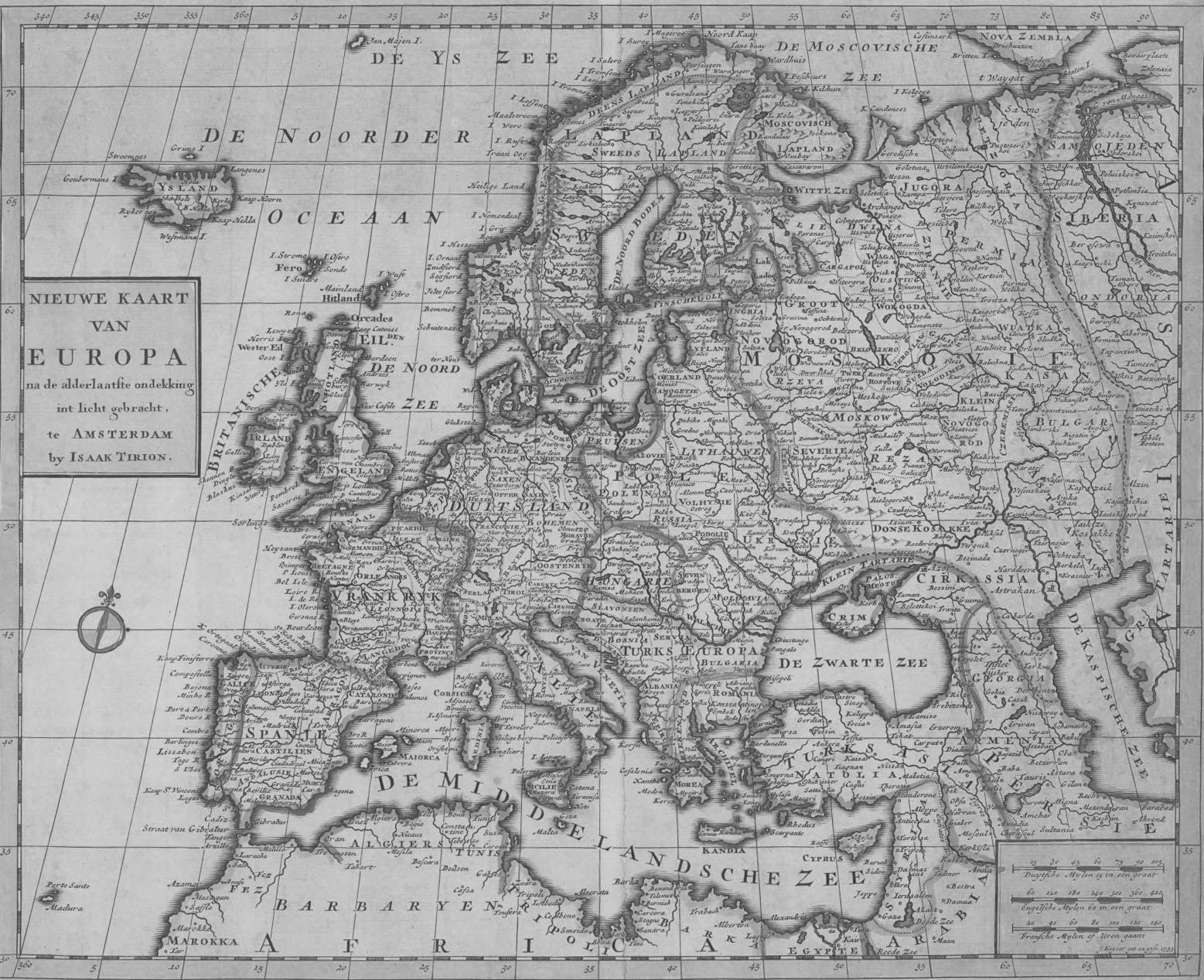
Isaak Tirion (1705-1765)
Nieuwe Kaart Van Europa, na de laatste ondekking int licht gebracht Amsterdam. 1732 39x34
The map depicts first half of the XVIII century Europe. Georgia is located between DE ZWARTEE ZEE (Black Sea) in the lower right corner and DE KASPISCHE ZEE (Caspian Sea) Despite the fact that in the first half of the XVIII century, Georgia was divided into small kingdoms, Tirion’s map follows the characteristic principle of European cartography, and the kingdoms are united under the toponymic “GEORGIA” (Sakartvelo). Isaak Tirion continues the tradition according to which, Georgia, although divided into kingdoms, still represented a common cultural space for European cartographers
Tirion does not fail to follow another tradition of the European cartography as well: indicating the spheres of influence of Ottoman and Persian empires, following the 1555 Amasya peace treaty, reflected by dotted line that crosses Georgia from North to South.
The map includes the following toponymics: Gonu (Gonio), Copolet (Kobuleti), Anarchia (Anaklia), Dander (likely, Dranda), Radja (Racha), Cotatis (Kutaisi), Usker (Atskuri), Gokia (Gokia), Zagen (Dzagemi) and Tiflet (Tbilisi)
ისააკ ტირიონი
ევროპის ახალი რუკა, ბოლო აღმოჩენების მიხედვით ამსტერდამი.
წ. 39x34 რუკაზე XVIII საუკუნის I ნახევრის ევროპაა წარმოდგენილი. საქართველო რუკის მარჯვენა ქვედა კუთხეში DE ZWARTE ZEE-სა
და რეგიონის სხვა ქვეყნების ტერიტორიები ორი დიდი იმპერიის ოსმალეთის და სპარსეთის გავლენის სფეროებად არის გაყოფილი გავლენის სფეროები რუკაზე წერტილოვანი ხაზებით არის აღნიშნული და საქართველოს შემთხვევაში ქვეყანას ჩრდილოეთიდან სამხრეთით კვეთს რუკაზე იკითხება შემდეგი ტოპონიმები: Gonu (გონიო), Copolet (ქობულეთი), Anarchia
Dander (სავარაუდოდ,დრანდა), Radja
(1705-1765)
1732
(ანაკლია),
(რაჭა), Cotatis (ქუთაისი), Usker (აწყური), Gokia (გოკია) Zagen (ძაგემი) და Tiflet (თბილისი).
თურქეთის აღმოსავლეთ ნაწილის, ირანის, შუა აზიის სამხრეთი და ავღანეთის ნაწილების ჩათვლით საქართველოს აღსანიშნავად გამოყენებულია წარწერა TRYKVAN GEORGIE (საქართველოს სამეფო) მხარეებიდან ცალკე არის დატანილი Guria (გურია) და Imirete (იმერეთი). რუკაზე მრავლად არის წარმოდგენილი მდინარეთა ქსელი. ისააკ ტირიონის „სპარსეთის სამეფოს“ რუკაზე იკითხება 1555 წელს დადებული ამასიის ზავის შედეგად, საქართველოსა და რეგიონის სხვა ქვეყნების ტერიტორიების ორი დიდი იმპერიის, ოსმალეთის და სპარსეთის გავლენის სფეროებად გაყოფა გავლენის სფეროები რუკაზე წყვეტილი ხაზებით არის აღნიშნული და საქართველოს შემთხვევაში ქვეყანას, ჩრდილოეთიდან სამხრეთით კვეთს. რუკაზე აღნიშნულია: Gounia (გონიო), Capolet (ქობულეთი), Schatkfal (შეკვეთილი), Poti (ფოთი), Anargie (ანაკლია), Ilori (ილორი), Radja (რაჭა), Cotatis (ქუთაისი), Scander (სკანდის ციხე), Akhalzike (ახალციხე), Usker (აწყური), Gokia (გოკია), Akalkalaki (ახალქალაქი), Ali (ალი), Atchabeti (აჩაბეთი), Gori (გორი), Tamanis (დმანისი), B Goureja (გარეჯი), Bactriane (ბახტრიონი), Zagen (ძეგამი), Tifflet (თბილისი) და სხვ.
Isaak Tirion (1705-1765)
Nieuwe kaart van 't Ryk van Persie Amsterdam 1732 44x33
The map covers a wide territory, including contemporary Caucasus region, Eastern part of Turkey, Iran, South part of Central Asia and parts of Afghanistan.
Georgia is indicated with TRYKVAN GEORGIE (Georgian kingdom). Following regions are indicated – Guria and Imirete (Imereti). The map depicts the river network richly.
The map of “Persian Kingdom” by Isaak Tirion depicts division of the spheres of influence between the two large empires: Ottoman and Persian (resulting from 1555 Amasya peace treaty), including Georgia and other countries of the region The spheres of influence are shown through dotted line and in case of Georgia, passes through North-South vertical of the country
Tha map depicts: Gounia (Gonio), Capolet (Kobuleti), Schatkfal (Shekvetili), Poti (Poti), Anargie (Anaklia), Ilori, Radja (Racha), Cotatis (Kutaisi), Scander (Scander castle), Akhalzike (Akhaltsikhe), Usker (Atskuri), Gokia (Gokia), Akalkalaki, Ali, Atchabeti, Gori, Tamanis (Dmanisi), B. Goureja (Gareji), Bactriane (Bakhtrioni), Zagen (Dzageni), Tifflet (Tbilisi) and others
In the eastern part of the country, the border with North Caucasus is indicated with Caucase gebergte (the mountain range of Caucasus).
ისააკ
ამსტერდამი
რუკაზე
ვრცელი ტერიტორია,
Caucase gebergte-ზე (კავკასიონის მთათა სისტემა) გადის.
ტირიონი (1705-1765) სპარსეთის იმპერიის ახალი რუკა
1732 წ 44x33
დატანილია
თანამედროვე კავკასიის რეგიონის,
ქვეყნის აღმოსავლეთ ნაწილში, ჩრდ კავკასიასთან საზღვარი

გიიომ დელილმა, სულხან-საბას მიერ რუკის გამოცემაში შეტანილი განსაკუთრებული წვლილი, რუკაზე სულხან საბას პერსონალურად აღნიშნვით გამოხატა და რუკის აღწერაში მოიხსენია, როგორც Sofkam Sabas Prince de Geoorgie (სულხან საბა, ქართველი თავადი). სულხან-საბას პიროვნული ღვაწლი და აღნიშვნა დატანილია, როგორც რუკის 1723 წლის პარიზულ, ისე 1732 წლის ამსტერდამულ გამოცემაზე. რუკა იმდენად დეტალურია, რომ მასზე ასახულია საქართველოს ყველა სამეფოსამთავრო და მხარე, არაერთი გეოგრაფიული პუნქტი, ქალაქი, სოფელი, მდინარე, ტბა, მთა, ციხესიმაგრე, ეკლესია-მონასტერი, გზა, და ა შ
Guillaume Delisle (1675-1726), Publishing house – “Covens & Mortier” (16851866), Jean Covens (1697-1774), Corneille Mortier (1699-1783) Carte Des Pays Voisins De La Mer Caspienne Amsterdam. 1732 76x61
The Map of the Caspian Sea Neighborhood by Guillaume Delisle is the first detailed map, providing information both about Georgia, as well as the neighboring countries of the region. There are two editions of the map: 1723 Parisian and 1732 Amsterdam publications.
Georgian diplomat, traveler and writer – Sulkhan-Saba Orbeliani played an important role in providing detail to the map, as well as fixing the mistakes on the old maps and introducing new information During his diplomatic mission to Europe in 1712-1714, he delivered cartographic and other information about Georgia and its neighboring countries Delisle expressed his gratitude towards significant contributions by SulkhanSaba through personal note on the map, which indicates “Sofkam Sabas Prince de Geoorgie” (Sulkhan-Saba, Georgian lord). Sulkhan-Sabas’ contributions are depicted on both 1723 Parisian, as well as the 1732 Amsterdam publications
The map is so detailed that it reflects all kingdoms and regions of Georgia, as well as numerous locations, cities, villages, rivers, lakes, mountains, castles, churches, monasteries, roads, etc.
Both Parisian and Amsterdam publications include toponymics matching Georgian pronunciation: Argueti (Argveti), Kevi (Khevi), Tianeti (Tianeti), Manglisi (Manglisi), Trialetti (Trialeti), etc
The map of Delisle is a “birth certificate” of sorts, as numerous toponymics appeared on his maps in European cartography for the first time This map depicts toponymic Aichara (Adjara) and Matchikeli (Machakheli) for the first time.
Georgia is indicated on the map as Georgie and Carduel Guria (Guria), Mingrelie (Samegrelo), Imiret (Imereti), Souanes (Svaneti), Georgie (Kartli) and Caket (Kakheti) are indicated in larger fonts
Guria (გურია), Mingrelie (სამეგრელო), Imiret (იმერეთი), Souanes (სვანეთი), Georgie (ქართლი) და Caket (კახეთი)
გიიომ
გიომ დელილის „კასპიის ზღვის მეზობელი ქვეყნების რუკა“, პირველი დეტალური რუკაა, სადაც წარმოდგენილია ცნობები, როგორც საქართველოს, ისე რეგიონის მეზობელი ქვეყნების და მხარეების შესახებ. არსებობს რუკის ორი გამოცემა: 1723 წლის პარიზული და 1732 წლის ამსტერდამული. რუკის დეტალურობას, ძველ რუკებზე არსებული შეცდომების გასწორებასა და რუკაზე ახალი ინფორმაციის დატანაში, მნიშვნელოვანი როლი აქვს შესრულებული ქართველ დიპლომატ, მოგზაურსა
ორბელიანს მან
კარტოგრაფიული და სხვა სახის
საქართველოს
Argueti (არგვეთი), Kevi (ხევი), Tianeti (თიანეთი), Manglisi (მანგლისი), Trialetti (თრიალეთი) და ა შ ევროპულ კარტოგრაფიაში ბევრი სახელწოდებისთვის გიიომ დელილის რუკა ერთგვარი „დაბადების მოწმობაა“ სწორედ ამ რუკაზე ჩნდება პირველად ტოპონიმები Aichara (აჭარა) და Matchikeli (მაჭახელი). რუკაზე საქართველოს აღმნიშვნელად გამოყენებულია Géorgie და Carduel. მთავრული შრიფტით არის
დელილი (1675-1726), საგამომცემლო სახლი - „კოვენსი და მორტიერი“ (1685-1866), იან კოვენსი (1697-1774), კორნელიე მორტიერი (1699-1783) კასპიის ზღვის მეზობელი ქვეყნების რუკა ამსტერდამი. 1732 წ. 76x61
და მწერალ სულხან-საბა
1712-1714 წლებში, ევროპაში დიპლომატიური მისიით მოგზაურობის დროს, თან ჩაიტანა
ცნობები
და მეზობელი ქვეყნების შესახებ
როგროც პარიზულ, ისე ამსტერდამულ გამოცემაში, საქართველოსთან დაკავშირებული ტოპონიმები, როგორც წესი, ქართული დაწერილობის მიხედვით არის დატანილი:
დატანილი:

რუკაზე კონტინეტური ევროპის გარდა წარმოდგენილია, კუნძულ გრენლანდიის უკიდურესი სამხრეთი და აფრიკის ჩრდილოეთი ნაწილები ასევე, შავი ზღვის სანაპირო ზოლი. შავი ზღვის აღსანიშნავად გამოყენებულია მისი ერთ-ერთი ძველი სახელწოდება Pontus Euxinus (სტუმრათმოყვრე ზღვა) შავი ზღვის აღმოსავლეთ სანაპირო ზოლში აღნიშნულია საქართველოს ქალაქები: Genca-ს (გონიო), Lonati (ბათუმი), Fab (ფაზისი) კარგად იკითხება Savatopoli (სოხუმი) და S.Sophia (სანტა-სოფია). რუკაზე საქართველო მხოლოდ ნაწილობრივ, ქვეყნის დასავლეთში
Henry de Sauzet (1687-1754)
Nova Eeuropae Descriptio Amsterdam, 1734 35x28
The major focus of the map is directed towards the European continent. Apart from the continental Europe, however, the map depicts the farthest South of the island Greenland and the Northern parts of Africa, as well as the coast of the Black Sea Black Sea is indicated with one of its old names – Pontus Euxinus (hospitable sea).
Georgian cities are marked towards the Eastern part of the Black Sea coast: Genca (Gonio), Lonati (Batumi), Fab (Phasis). Savatopoli (Sokhumi) and S. Sophia (SantaSophia)
The map depicts only Western seaside cities of Georgia.
ანრი დე სოზე
ახალი ევროპის აღწერა ამსტერდამი,
წ
რუკის მთავარი ფოკუსი ევროპის კონტინენტისკენ არის მიპყრობილი. ამის მიუხედავად,
(1687-1754)
1734
35x28
მდებარე საზღვაო ქალაქებით არის წარმოდგენილი.

ჰენდრიკ იენსენ ვან ვაესბერგი (1687-1748)
თბილისი, საქართველოს დედაქალაქი ამსტერდამი. 1737 წ.
თბილისელი ქალები ამსტერდამი. 1737 50x33
თბილისის ერთ-ერთი ყველაზე პოპულარული გრავიურა, 1737 წელს, ვაესბერგის მიერ გამოცემულ "Beschryving van eene Reize naar de Levant"-ში (ლევანტში მოგზაურობის აღწერა) არის შეტანილი გამოცემა ნიდერლანდურ ენაზეა შესრულებული ქალაქის ეს ხედი, ისევე როგორც თბილისელი ქალების ჩანახატი, ფრანგი ბოტანიკოსის და მოგზაურის, ჟოზეფ პიტონ დე ტურნეფორის საქართველოში მოგზაურობის დროს არის შესრულებული ჩანახატების ავტორი, ფრანგი მხატვარი კლოდ ობრიეა იგი 1701 წელს ტურნეფორს თან ახლდა თბილისში. მიუხედავად იმისა, რომ ვაესბერგის გამოცემაზე, თბილისის ჩანახატს არ ერთვის შენობა-ნაგებობების აღმნიშვნელი მინაწერები, ბევრი ობიექტის
Hendrick Janssonius van Waesberge (1687-1748)
Teflis Capitale de Georgie Amsterdam. 1737
Femes de Teflis Amsterdam. 1737 50x33
One of the most popular gravures of Tbilisi is included in the 1737 publication "Beschryving van eene Reize naar de Levant" by Waesberg (description of travels to Levant) The publication is made in Dutch This particular view of the city and the Tbilisian women, depicted on the gravure was sketched during the travels of the French botanist and traveler, Joseph Pitton de Tournefort, while in Georgia. French artist –Claude Aubriet is the artist behind the sketch itself The artist followed Tournefort in his travels to Tbilisi in 1701.
Even though the Waesberg publication of the sketch does not include description of the buildings, many of them can be identified easily. On the right side of the riverbed, there is Narikala fortress overlooking the city, followed by the water channel The walls of the castle follow into the Mtkvari riverside. Inside the castle to the left, there is a royal hall. Other important buildings, including churches, caravanserais can be identified as well.
The sketch of Tbilisian women is the first sketch of Tbilisians that reached our times. It is notable that the artist did not use his imagination or information from others – he sketched what he saw
რაც სიღრმეში წყლის არხით გრძელდება. ნარიყალას ციხის მიმდებარე ტერიტორიიდან ქალაქის გალავანი ეშვება და მტკვრის სანაპიროს მიუყვება. გალავნის შიგნით, მარცხნივ, სამეფო სასახლეა შესაძლებელია ეკლესიების, ქარვასლის და სხვა მნიშვნელოვანი შენობა-ნაგებობების იდენტიფიცირება. თბილისელი ქალების ჩანახატი თბილისის მცხოვრებთა ჩვენამდე დადასტურებულად მოღწეული პირველი ჩანახატია. აღსანიშნავია, რომ მხატვარი მისი შესრულებისას ეყრდნობოდა არა წარმოსახვას ან სხვათა მოწოდებულ ცნობებს, არამედ ხატავდა საკუთარი თვალით ნანახს.
იდენტიფიცირება იოლად შეიძლება მდინარის მარჯვენა სანაპიროზე, ქალაქის თავზე ნარიყალას ციხეა,

ინფორმაცია ზღვის დასავლეთ და აღმოსავლეთ სანაპიროს შესახებ. ამის მიუხედავად, 1742 წელს, ამსტერდამში, საგამომცემლო სახლ „კოვენსი და მორტიერი“ს მიერ გამოცემულ რუკაზე, საქართველოსთან დაკავშირებული არაერთი საინტერესო აღნიშნვაა. შავი ზღვის აღმოსავლეთ სანაპიროზე, სამხრეთიდან ჩრდილოეთის მიმართულებით რუკაზე დატანილია: Matchikeli (მაჭახელი), Aichara (აჭარა), GURIA (გურია) და ROYAME DE MINGRELIE (სამეგრელო).
რუკაზე ცალკე არის აღნიშნული შემდეგი ხუთი პორტი: Port de Gounia (გონიო), Port de Copolet (ქობულეთი),Port d’ Anargia (ანაკლია), Port de Sahoum (სოხუმი), Port de Poutchinda (ბიჭვინთა). კარგად იკითხება: Batham (ბათუმი), Orouskeli (ოზურგეთი), Poti (ფოთი), Kopy (ხობი), Fort de Ruh (რუხის ციხე), Bedia (ბედია), Tranta (დრანდა) და სხვა არაერთი კიდევ
Guillaume Delisle (1675-1726), Publishing house – “Covens & Mortier” (16851866), Jean Covens (1697-1774), Corneille Mortier (1699-1783) Seconde partie de la Crimee, la Mer Noire Amsterdam, 1742 70x60
The map provides rich depiction of the South shore of the Black Sea. There is comparably less information about the West and the East shores of the Sea. Despite this, published in 1742 Amsterdam, the map by “Covens & Mortier” offers numerous interesting indications related to Georgia.
At the Eastern shore of the Black Sea, from the South towards the North, the map indicates Matchikeli (Machakheli), Aichara (Adjara), GURIA and ROYAME DE MINGRELIE (Samegrelo)
The map separately indicates the following five ports: Port de Gounia (Gonio), Port de Copolet (Kobuleti), Port d’Anargia (Anaklia), Port de Sahoum (Sokhumi), Port de Poutchinda (Bichvinta).
There are clear indication of Batham (Batumi), Orouskeli (Ozurgeti), Poti, Kopy (Khobi), Fort de Ruh (Rukhi castle), Bedia, Tranta (Dranda) and numerous others.
შავი ზღვის სამხრეთის სანაპირო. შედარებით ნაკლებია
გიიომ დელილი (1675-1726), საგამომცემლო სახლი - „კოვენსი და მორტიერი“ (1685-1866), იან კოვენსი (1697-1774), კორნელიე მორტიერი (1699-1783) ყირიმის მეორე ნაწილი, შავი ზღვა ამსტერდამი, 1742 წ 70x60 რუკაზე ვრცლად არის წარმოდგენილი

პიერ მასიუე (1698-1776) მსოფლიო გეოგრაფიასა და ცოდნაში შესავლისთვის გამოსაყენებელი რუკა ამსტერდამი. 1752 წ. 42x19 რუკაზე წარმოდგენილია როგორც ევროპა, ისე აზია და აფრიკის კონტინენტის ჩრდილოეთი ნაწილი საქართველოსთან დაკავშირებული ცნობა მოცემულია შავი და კასპიის ზღვებს შორის არსებულ ტერიტორიაზე (რუკაზე ზღვების სახელწოდებები არ არის დატანილი). საქართველო აღნიშნულია სახელწოდებით: GEORGIE. რუკის მარჯვენა და მარცხენა კიდეებში დატანილია წერილობითი ცნობები, რომლის მიხედვითაც მე-7 აღნიშვნა უკავშირდება Colchide-ს (კოლხეთი)
Pierre Massuet (1698-1776)
Carte Pour Servir d'Entrée et d'Introduction a la Géographie et a l'Intelligence de l'Histoire Universele Amsterdam 1752 42x19
The map includes both Europe as well as Asia and the Northern part of Africa The information about Georgia is indicated on the territory, between the Black and the Caspian seas (the map does not indicate the names of the seas). Georgia is indicated as GEORGIE
The right and the left sides of the map include written information, according to which, the seventh indication is related to Colchide (Kolkheti/Colchis).

ნ.ტ. გრავიუსი (XVIII საუკუნის II ნახევარი)
ევროპის რუკა ამსტერდამი 1788 წ
აზიის რუკა ამსტერდამი 1788 წ 58x24 გრავიუსის მიერ 1788 წელს ამსტერდამში გამოცემული ევროპის და აზიის ორივე რუკაზე შესაძლებელია საქართველოსთან დაკავშირებული ცნობების ნახვა, თუმცა, საკუთრივ საქართველო, მათზე აღნიშნული არ არის. ევროპის რუკაზე იკითხება Akalzike (ახალციხე) და Teflis (თბილისი) შესაძლებელია მდინარე მტკვრის იდენტიფიცირებაც, თუმცა მდინარეზე წარწერა არ არის დატანილი. აზიის რუკაზე მხოლოდ თბილისია აღნიშნული და აქაც, ისევე როგორც
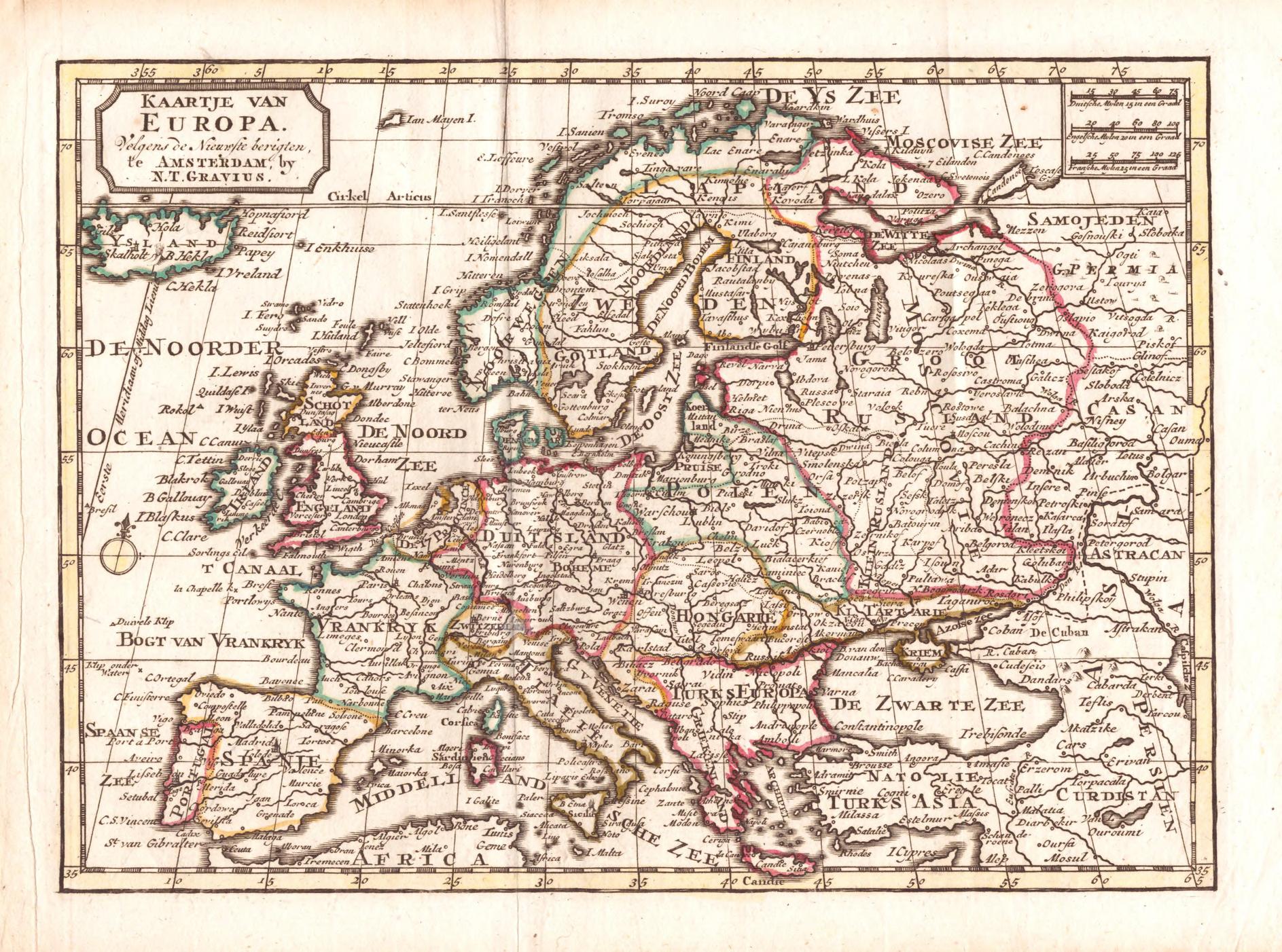
N.T. Gravius (second half of the XVIII century)
Kaartje van Europa Amsterdam 1788
Kaartje van Asia Amsterdam 1788 58x24
Both maps (of Europe and Asia) published by Gravius in 1788 Amsterdam include the information about Georgia However, Georgia is not indicated on either
The map of Europe reads Akalzike (Akhaltsikhe) and Teflis (Tbilisi). River Mtkvari is visually identifiable too, however, there is no written indication of it The map of Asia only indicates Tbilisi, and just like in case of the map of Europe, the toponymic “Teflis” is used, which was characteristic for European Cartography for centuries
ევროპის რუკაზე, გრავიუსი ქალაქის აღსანიშნავად იყენებს ტოპონიმს - „Teflis”, რაც საუკუნეების განმავლობაში დამახასიათებელი იყო ევროპული კარტოგრაფიისათვის.

Biographies

ბიოგრაფიები
(1512-1594)
One of the greatest Flemish cartographers from Rupelmonde, educated in Leuven University. Moved to Duisburg in 1552. Creation of the projection in cartography is considered to be one of his greatest achievements and it carries his name today. Mercator is also known for coining the term “Atlas” for the first time. In 1595, Atlas of Mercator was published in Duisburg for the first time აბრაჰამ ორტელიუსი (1527-1598)
Abraham Ortelius (1527-1598)
One of the greatest cartographers from Antwerp of the XVI century, who has influenced the development of cartography substantially. Ortelius had close relations with another great cartographer of the century – Gerrard Mercator.
In 1570, Abraham Ortelius became the first cartographer, who published the first contemporary atlas “Theatrum Orbis Terrarum”, bringing him great recognition. From 1570 until his death (1598), Ortelius’s atlas was published 25 times in Latin, Italian, German and Dutch languages.
გერარდ მერკარტორი (1512-1594) უდიდესი ფლანდრიელი კარტოგრაფი რუპელმონდიდან. განათლება მიიღო ლუვენის უნივერსიტეტში. 1552 წელს საცხოვრებლად გადავიდა დუისბურგში. მერკატორის ყველაზე დიდ დამსახურებად კარტოგრაფიის ისტორიაში პროექციის შექმნა მიიჩნევა, რომელიც დღეს მის სახელს ატარებს. იგი ასევე ცნობილია როგორც ავტორი ტერმინისა ,,ატლასი“. მერკარტორის ატლასი პირველად, მისი გარდაცვალებიდან ერთი წლის შემდეგ,
1595 წელს, დუისბურგში დაიბეჭდა. Gerard Mercator
XVI საუკუნეში მოღვაწე უდიდესი კარტოგრაფი ანტვერპენიდან. მან დიდი გავლენა მოახდინა კარტოგრაფიის შემდგომ განვითარებაზე. ახლო ურთიერთობა ჰქონდა იმავე საუკუნის კიდევ ერთ დიდ კარტოგრაფ გერარდ მერკარტორთან. 1570 წელს, აბრაჰამ ორტელიუსი გახდა პირველი კარტოგრაფი, ვინც მსოფლიოს პირველი თანამედროვე ატლასი „Theatrum Orbis Terrarum“ გამოსცა. ამ ფაქტმა მას უდიდესი აღიარება მოუტანა. 1570 წლიდან მოყოლებული, ორტელიუსის გარდაცვალებამდე (1598 წ.), ლათინურ, იტალიურ, გერმანულ და ნიდერლანდურ ენებზე, ატლასი 25-ჯერ გამოიცა.
ერთად მცირე ზომის სამოგზაურო ატლასი მოამზადა. Matthias Quad (1557-1613) Cartographer and gravure craftsman working towards the end of XVI and beginning of XVII from Deventer. Quad received education in Harlem, with Hendrick Goltzius. In 1587, Quad moved to Cologne, where, together with Johann Bussemacher he developed the travel atlas. In 1594 his atlas “Description of Europe” was published, containing 50 maps.
Balthasar Moretus (1574-1641)
of the maps and books and trader from Antwerp. For years he headed the company, founded by his grandfather. He is credited with the best publication of the Ortelius’s atlas, Parergon (published in 1624).
Prominent representative of the Golden Age of the Dutch cartography, from the city of Arnhem, who actively participated in the re-publication of the atlas by Mercator and Hondius
მათიას ქუადი (1557-1613) XVI საუკუნის ბოლოს და XVII საუკუნის დასაწყისში მოღვაწე, კარტოგრაფი და გრავირების ოსტატი დევენტერიდან. პროფესიული განათლება მიიღო ჰარლემში, ჰენდრიკ ჰოლციუსთან. 1587 წელს საცხოვრებლად გადავიდა კელნში, სადაც იოჰან ბუშმესტერთან
ბალთაზარ მორეტუსი
რუკების და წიგნების გამომცემელი და ვაჭარი ანტვერპენიდან. წლების განმავლობაში ხელმძღვანელობდა ბაბუის მიერ დაფუძნებულ კომპანიას. მის სახელს ეკუთვნის აბრაჰამ ორტელიუსის პარერგონის ატლასის საუკეთესო,
წლის გამოცემა.
იოჰანეს იანსონიუსი
ნიდერლანდური კარტოგრაფიის ოქროს საუკუნის შესანიშნავი წარმომადგენელი ქალაქ არნემიდან. აქტიურად მონაწილეობდა მერკარტორჰონდიუსის ატლასის ხელახალი გამოცემის საქმეში.
(1574-1641)
1624
Publisher
(1588-1664)
Johannes Janssonius (1588-1664)
Blankaart (approx. 1624-1703) Dutch scholar, professor from Leiden. His maps, of the three continents, prepared for Johannes Janssonius (of Europe, Asia and Africa) are well known.
Cluver (1580 -1622)
and historian of German origin. Studies law in Leiden University. After numerous travels, since 1615, settled in Leiden, where he was elected as a academic in the field of geography.
ნიკოლას ბლანკაარტი (დაახლ.
ნიდერლანდელი სწავლული, პროფესორი ლეიდენიდან. ცნობილია მისი სამი კონტინენტის: ევროპის, აზიის და აფრიკის
მოამზადა.
ფრედერიკ დე ვიტი
ნიდერლანდური კარტოგრაფიის ოქროს საუკუნის წარმომადგენელი გაუდადან. 1648 წლიდან საქმიანობდა ამსტერდამში. რუკების შექმნის პარალელურად დაკავებული იყო მათი გაყიდვით.
ატლასებით და ნიდერლანდების ქალაქების
Frederick De
(approx.
Dutch
ფილიპ კლუვერი (1580 -1622) წარმოშობით გერმანელი გეოგრაფი და ისტორიკოსი. სწავლობდა სამართალს ლეიდენის უნივერსიტეტში. არაერთი მოგზაურობის შემდეგ, 1615 წლიდან, დასახლდა ლეიდენში, სადაც აირჩიეს აკადემიკოსად გეოგრაფიის დარგში.
1624-1703)
რუკები, რომელიც იოჰანეს იანსონიუსისთვის
Nicolaus
(დაახ.1629-1706)
1660 წლიდან აქვეყნებდა ატლასებს. ცნობილია
რუკებით.
Wit
1629-1706)
Cartographer of the Golden Age from Gouda. Since 1648 worked in Amsterdam. Created and sold maps. Since 1660 published atlases. Cartographer is known for his atlases and the maps of the Dutch cities.
Philipp
Geographer
Peter Bertius (1565 -1629) Flemish theologist, historian, geographer and cartographer. Since 1593 is a librarian and professor of Leiden University. One of his most important cartographic works is the world miniature, so-called “Pocket Atlas” dated with 1600.
1681 წელს საცხოვრებლად გადავიდა ინგლისში. 1683 წელს ინგლისის ოსტ-ინდოეთის კომპანიის
(East India Company) დაინიშნა ჰოლანდიაში. Jean Chardin (1643-1713) French traveller, jeweler and trader of gemstones. Visited Georgia in 1672-1673. In 1681 moved to England. In 1683 appointed as an agent of East India Company of England in the Netherlands.
პიტერ ბერტიუსი (1565 -1629) ფლანდრიელი თეოლოგი, ისტორიკოსი, გეოგრაფი და კარტოგრაფი. 1593 წლიდან ლეიდენის უნივერსიტეტის ბიბლიოთეკარი და პროფესორი. მისი ერთ-ერთი უმთავრესი კარტოგრაფიული ნამუშევარია 1600 წლით დათარიღებული მსოფლიოს მინიატურული ე.წ.
ჯიბის ატლასი.
ჟან შარდენი
ფრანგი მოგზაური, იუველირი და ძვირფასი ქვებით მოვაჭრე.
წლებში იმყოფებოდა საქართველოში.
გიიომ ჟოზეფ
(დაახლ.
ფრანგი მხატვარი. სპარსეთში მოგზაურობის დროს თან ახლდა ძვირფასი ქვებით მოვაჭრე ჟან შარდენს. სავარაუდოდ, სწორედ გრელოს შესრულებული უნდა იყოს შარდენის მოგზაურობის ამსახველი ჩანახატები. მათ შორის, მეგრელი მამაკაცის გამოსახულება, რომელიც 1687 წელს ამსტერდამში გამოცემული შარდენის მოგზაურობის წიგნის სატიტულო გვერდზე გვხვდება.
(1643-1713)
1672-1673
აგენტად
გრელო
1630-1680)
Tbilisi

თბილისი
2022