IMPACT OF TOURISM-DRIVEN URBANISATION
The Ice Stupa Project Source: (Maheshwary, Raspall, & Verma , 2019)
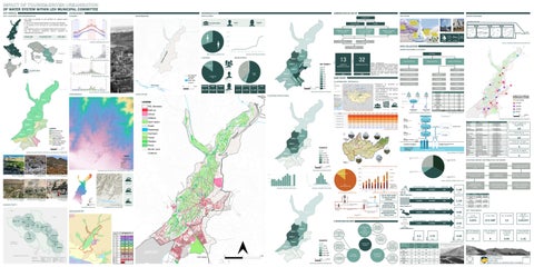
OF WATER SYSTEM WITHIN LEH MUNICIPAL COMMITTEE CITY PROFILE SITE LOCATION AND DEMARCATION
The most infamous and practiced model in Ladakh is known to be the Ice Stupa, invented by Mr. Sonam Wangchuk, who is an engineer by profession. The ice stupa is an innovative snow
The process of site selection comes on the basis of water availability, the elevation and the harvesting method in Ladakh and has been high praised.
slope of the land, and minimum exposure of ice stupas to the sunlight. The water is then
ENVIRONMENT CLIMATE
DEMOGRAPHICS POPULATION
WATERBODIES
• LEH TOWN IS LOCATED IN LEH DISTRICT OF LADAKH UNION TERRITORY • IT LIES IN THE RAINDHADOW REGION OF HIMALAYAN RANGES • IT IS LOCATED AT AN ALTITUDE OF 3,500 METRES ABOVE SEA LEVEL • THE AVERAGE SLOPE IS 10 DEGREES FROM NORTH TO SOUTH • THE LEH MUNICIPLE COMMITTEE MOSTLY CONSISTS OF RESIDENTIALS AND HOTELS
MCL
functions freezing of the waterpipes, streams vertically a structure which forms pyramid diverted by gravity fromItthe upper by stream using plastic which are ofonhigh-density,
ADMINISTRATIVE SETUP
shaped ice or cones of about 30 to 50 metre in height that looks similar to the architectural term
usually laid underground after the selection of the suitable site. A vertical pipe is erected from
“stupas”. The design is such that, it requires no pump or external pressure for the freezing of
MALE 21,699
water and is environment adaptive. The stupa is shaped in a way that less surface area is
ICE STUPA
LADAKH (UT)
LEH POPULATION 30,870
the center of the stupa, which has a sprinkler on the top spraying out water (as depicted in Literature Review Image 8) which looks like a fountain due to hydrostatic pressure. exposed to the winds and sun to delay the melting.
WATER STORAGE COVERED SURFACE
FEMALE 9,201
LEH DISTRICT
KARGIL
LADAKH AUTONOMOUS HILL DEVELOPMENT COUNCIL (LAHDC)
MUNICIPAL COMITEE OF LEH (MCL)
GOBAS / VILLAGE HEADMANS
ICE STUPA STRUCTURES IN LEH
LAND
WATER STORAGE
Literature Review Image 7 Photo of an Ice Stupa in Ladakh (Photo Courtesy: Sierra Gladfelter)
Literature Review Image 8 Ice Stupa can be seen with sprinkler at the top spraying out water
There are 4 factors considered when an ice stupa is built, first comes the site selection of a
LEH DISTRICT AREA 45,110 KM2
LADAKH AREA 59,146 KM2
During the melting period suitable of the glaciers, the ground icesupply stupasfor will laid is covered area, a water streamwhere which the could thebecreation of ice stupas, then comes the
STUDY AREA 17.1 KM2
1 MLD the ice stupas comes from unique its shape and the and ice aggregation maintained using branches of WATER sea challenges a critical andistechnical understanding is important.
with clays for reduction of permeability and to of stop seepage. The structuralEach stability of comes with its own designing and erecting therapid structure and the headworks. factors
WARD 1
buckthorn and barbed wires surrounding the ice stupas. The structure also has arched tunnel
30%
AVERAGE TEMPERATURE IN LEH
WATER
UPPER LEH
LOWER LEH
sprinklers. ICE STUPA CONCEPT
WATER SOURCES & SUPPLY
MS
is more accessible and can be created at lower elevations, closer to villages and towns.
SOURCE: CENSUS 2011
LEH POPULATION 30,870
36.61%
WARD 4 WARD 5 MAIN 55.4%
11
CULTIVATORS
6,590 LIT. 2,611 ILLIT.
LAND COVER
2.01%
AGRICULTURE
0.56%
INDUSTRY
CASE STUDY
The ice stupa currently is the most efficient way of harvesting snow water, even though this requires ma labour, but since it’s a practical which amounts to the least failure unlike the
SURFACE WATER
GOBA / NAMBARDAR GOBA OR NAMBARDAR ARE HEADPERSONS WHICH ARE INFORMALLY ELECTED. GOBA IS A TRADITIONAL CONCEPT OF LADAKH AND THEY WORK AT THE GROUND LEVEL IN EVERY SUB-AREA OF LEH WITH ISSUES RELATED TO LAND, FINANCE, RESOLVING DISPUTE ETC.
GROUND WATER
process to make it easier and get robust understanding of the surroundings for ice stupa implementation.
GYALUNG SPRINGS
LAMDON
GANGLES SPRINGS
MURTSEY
SANKAR
T-TRENCH
KHAKSHAL
BADAMI BAGH
TUKCHA
SKARA
JUMABAGH
GOMPA
Irrigation in Southern and Eastern Asia in figures - AQUASTAT Survey - 2011
• MONGOLIA Case Study Figure 1 Map of Mongolia
IS SITUATED IN CENTRAL ASIA • IT IS BORDERED BY CHINA TO THE WEST, RUSSIA TO THE NORTH, WARD-WISE POPULATION DENSITY EAST AND SOUTH Climate • ULAANBAATAR IS THE CAPITAL Ulaanbaatar has severe cold climatic conditions which prolongs forOF a long time in an year. The CITY MONGOLIA • THE IS SITUATED lowest average temperature in the city is -22.02 degree Celsius withCITY a record low of AT -4413,000 degree METERS ABOVE SEA LEVEL
OTHERS
0.13% 97.31% FLOATING POPULATION
WARD 1
Page | 56
SURFACE STREAMS
villages through a 250mm diameter Mild Steel
Tube Wells Murstey Khakshal Tukcha Jumabagh Lamdon Sankar Badami Bagh Skara Gompa
Celsius and having 34 degrees Celsius as the highest temperature in the city. The coldest Water Resources months are December and January, and the hottest months are June and July. Mongolia is situated on three international river basins, namely:
1.6 MIL a. The Arctic Ocean Basin also known as the Yenisei River Basin, which is4,704.4 locatedKM on the 13,000 M 2
MONGOLIA MAP HIGHLIGHTING ULAANBAATAR
northern and central Mongolia. The total length of the Yenisei River basin spans 35,000 km.
13 D
"
" "
"
" "
WARDS WITH SETTLEMENT PATTERN OF LEH MUNICIPAL COMMITTEE
" "
Gadia
"
CM111
Cut-off Meander (CM)
" "
"
" " " "
"
"
" "
RW TW
LS
10-15 m
Very High
200-300 LPM
10
P
Areas with high Arsenic concentration.Limited potability of groundwater.
Not Required
"
"
" "
" "
" "
"
"
"
"
"
"
" "
AGRICULTURAL AREA WARD 1-6
HILL SETTLEMENTS WARD 11-12
ORGANIC SETTLEMENTS (HIGH) WARD 13
MS111
" "
"
"
"
"
9 AM
ISRO's Geoportal | Gateway to Indian Earth Observation | 2D Viewer
Ministry of Drinking Water and Sanitation
Bhuvan - Bhujal (Ground Water Prospects and Quality Information System)
CONNECTIVITY d Water Prospects
B
A
trict: Leh
N
G
L
A
D
E
S
H
WARD-WISE TOURISM DENSITY 14% SURFACE WATER No well observed
Good
RW TW
LS
10-15 m
High
200-250 LPM
P
N il
Groundwater prospects very high with high recharge potential. Recharge structures not required.
Not Required
WATER SOURCE DISTRIBUTION
H o l o c e n e )
3302.4 M
F
F
D D
D D
Hybrid
Alluvium (Sand and Silt) (113)
Terrain
Q Q
P P
Alluvial Plain Younger (APY)
No well observed
LS
Good
80-100 m
TW
400-500 LPM
NP (As & Fe) [At shallow depth]
High
3703.8 M
99
INTCENTISING HOUSEHOLD WITH WASTE WATER USE
< 30 METERS
30 - 80 METERS
> 80 METERS
GROUND WATER IRRIGATED AREA
E E E E E E E E E E E E
RIVER / STREAM (with sand)
VIOLET
@
SUB - VERTICAL TO VERTICAL ( > 80 )
¼
! «
PERCOLATION TANK NALA BUND DESILTING OF TANK
GREEN
SUBSURFACE DYKE SOIL CONSERVATION MEASURES
CHECK DAM
! §
RECHARGE WELL RECHARGE PIT RECHARGE SHAFT STORAGE TANK
! (
^ I ´
WELLS OBSERVED DURING FIELD VISIT
YELLOW
YIELD RANGE IN LPM
2.05 MLD
0.51 MLD
40%
3
! 15/70
25 - 50 m / day
! 15/70
3
3
15 - 25 m / day
! 8/15 ( ! 8/15 ( ! 8/15 (
(Inselberg / Ridge / Dyke etc.)
15/70
PREPARED BY
GEOINFORMATICS & REMOTE SENSING CELL
THRUST
F T
F
F
T
T
F T
"
"
"
"
"
"
"
"
"
BLOCK INDEX "
INTERNATIONAL
"
MAPSHEET INDEX
" "
79A10
79A14
79E02
"
WARD 7
BLOCK
"
79A11
"
79A15
79E03
21 Interview with UBDS (14 April 2016)
SHEAR ZONE
( Confirmed / Inferred)
S
S /S
S
DYKE
( Confirmed / Inferred)
D
D/D
D
QUARTZ REEF
( Confirmed / Inferred)
Q
Q/Q
Q
! 8/15 (
! 15/70
< 5 m3 / day
! 8/15 (
( F
ARTESIAN WELL
! D
HAND PUMP WELL
ü
OBSERVATION WELL OF G.W DEPT. / C.G.W.B.
! (
TECHNICAL GUIDANCE & QUALITY CHECK
PEGMATITIE VEIN
( Confirmed / Inferred)
P
P/P
P
Lithologic contacts are inferred at places & Geomorphic boundaries are gradational
PARTICIPATING ORGANIZATIONS
OTHER INFORMATION
L3
79A12
Rainfall : 1444 mm (Source IMD) METHODOLOGY & PROJECT EXECUTION
ICE STUPA: EFFICIENT SNOW WATER HARVESTING
79A16
79E04
WARD 8
TECHNIQUES FOR MAPPING
changes in CHP5 technologies from wet to air cooled and the expansion and renovation of CHP#4 (however, the impact on water resources is uncertain).
L3-HANSKHALI L8-KRISHNAGANJ
WARD-WISE MIGRANT DISTRIBUTION SPONSORED BY
RAJIV GANDHI NATIONAL DRINKING WATER MISSION
ICE STUPAS
CPHEEO 22 These include changes in CHP5 technologies from wet to air cooled and the expansion and renovation of CHP#4. The & ARTIFICIAL extent of the reduced water demand requires verification. The energy estimates in the MEGDT (2012) Tuul Integrated GUIDELINES Water Management Plan seem too high. We assume this to be driven by changes occurring after publication, such as GLACIERS 12
Operational Built, Not Operational Operational Operational Operational Operational Operational Operational Under Construction Under Construction Operational Under Construction Built, Not Operational Built, Not Operational Total
TOTAL NO. OF OPERATIONAL RESERVOIRS
1,90,000 Zone 11 1,90,000 Zone 12 57,00,000 Zone 11 3,80,000 Zone 10 3,80,000 Zone 10 3,80,000 Zone 7 5,70,000 Zone 2 1,90,000 Zone 6 1,90,000 Zone 12 1,90,000 Zone 6-I 1,90,000 Zone 1 57,00,000 Bombguard 1,90,000 Zone 8 1,90,000 Zone 12 2,15,65,000
12 TOTAL NO. OF NONOPERATIONAL RESERVOIRS
3 TOTAL NO. OF UNDER CONSTRUCTION RESERVOIRS
3
LEH WATER DISTRIBUTION NETWORK SANCTIONED IN 1990s
60 KM PIPE LENGTH
GALVANIZED IRON PIPES 20-60MM DIAMETERS
WATER ONLY SUPPLIED FOR 2 HOURS AT PSP
100 PSP STILL OPRERATIONAL
PIPELINE IS CONNECTED TO 462 PUBLIC STAND POST
FREQUENT PIPE BREAKAGES DURING WINTER
WATER DISTRIBUTED THOUGH TANKS LEADING TO WATER WASTAGE
WATER TANKERS ARE EXPENSIVE COMPARED TO PIPED NETWORK
WASTAGE
% WASTAGE
2.10 MLD
0.53 MLD
39%
1.54
WATER EXTRACTED
WASTAGE
% WASTAGE
0.55 MLD
0.14 MLD
11%
0.41 MLD
WATER EXTRACTED
WASTAGE
% WASTAGE
1.6 MLD
0.13 MLD
11%
0.41
Heads Fuel or Electricity Labour Maintainance & Repairs Annual Cost Annual Water Supplied (KL) Cost per KL
Tankers Piped System 51,50,880 68,49,120 10,65,800 14,34,200 14,60,000 76,76,680
5,40,000 88,23,320
1,57,680 Rs. 49
7,96,032 Rs. 11
5,70,000 5,70,000
KEY TAKEAWAYS TOTAL POPULATION
TOTAL AREA
3,870
17.1 KM2
NO. OF SURFACE WATER SOURCES
6.3 MLD
1.31 MLD
3
5.00 MLD
57,00,000 95,000 1,90,000 1,90,000 57,00,000 3,80,000 3,80,000 3,80,000 NO. OF WARDS 5,70,000 1,90,000 1,90,000 1,90,000 1,90,000 57,00,000 1,90,000 1,90,000 2,15,65,000
NO. OF TOURISTS IN 2021
13
3,04,077
NO. OF PUBLIC TUBE WELLS
TOTAL MLD OF WATER SUPPLY
TOTAL WATER WASTAGE (MLD)
8
5.00
1.31
WATER SUPPLY IN MCL
"
L8
DISTRICT
FRACTURE / LINEAMENT ( Inferred )
A W
G
"
STATE
FRACTURE / LINEAMENT
RD
WARD 6
BOUNDARY :
! 8/15 (
5 - 10 m / day
DUG - CUM- BORE WELL
W
F
HABITATIONS : NON - COVERED (NC) PARTIALLY COVERED (PC)
)
MAJOR
MINOR
FAULT
3
10 - 15 m / day
15/70
!
!
" Ï )
3
Colour inside well symbol indicates yield range. The figures on the top right hand side of well indicate the depth to water level and depth of well in meters
RED
K-HUGLI L-NADIA M-MURSIDABAD N-MALDA
WARD 5
J I
10
50 - 100 m / day
H
E
ESCARPMENT LITHOLOGY / GEOMORPHIC UNIT BOUNDARY
WATER EXTRACTED
INDUS WATER LIFT
DEMARCATION
The water demand data for the energy sector requires an update. As of now, no information on water demandFAILURE? for the Amgalan HoB was available, nor for the two additionally planned HoB plants. The water demand estimates used in this study are expected to be too high, since publication of the water data provided in the Tuul LITERATURE Integrated Water Management Plan (MEGDT, 2012) changes impacting the water demand estimates have GUIDELINES HOB)) in operation since 2015. taken place. 22In addition to CHPs, there is a Heat-only-boiler (“Amgalan REVIEW FOR NEW WATER According to an ADB report, two more are planned. However, the Ministry of Energy has no information on these. The given uncertainties around additional water uses around energy prevented us from exchanging DISTRIBUTION actual water demand data for CHPs with given data. However, this is an area which requires more insights in PROPOSALS the future.
11
Badami Bagh Skara Balashram Mini Secretariat Manetseling Changspa Gyalung SR Jumabagh Kartse Stok Flow (new) Gonpa AMRUT Skampari Phu Skara
18
57,00,000 Zone 9 95,000 Zone 6-I
1.58
MLD
Ulaanbaatar City is implementing measure to reduce heat loss at household level, e.g. old apartments are being IS PPP A lined from outside. UBDS and Ulaanbaatar City are also performing annual improvement measures, replacing SUCCESS OR old and aging pipes, to reduce heat and water losses.
D
< 10 LPM
3
100 - 200 m / day
! 15/70
! 8/15 ( ! 8/15 (
D
WARD 12
Operational Operational
TOTAL NUMBER OF RESERVOIRS
EXISTING WATER DISTRIBUTION NETWORK
2.05
% WASTAGE
Pipe leakage WATER Illegal connections to heating network TECHNIQUES Improper use of heating pipes, e.g. some households withoutDISTRIBUTION hot water supply withdraw hot water from the FOR PROPOSING radiators to use for cleaning, some households with cool/warm radiators connect their radiator (central) to SYSTEM its sewage AND for hotter radiators. This is estimated to account for 5-10% of total make-up water required.
AR W
10 - 20 LPM
200 - 400 m / day
WEST BENGAL
CITY / VILLAGE
"
L
B
9
20 - 30 LPM
3
"
M
A
K
RAILWAY
TREND LINE
C
WARD 4
D
PINK
! 15/70
3
> 400 m / day
I N D I A
OTHER ROAD
N
AR W
50 - 100 LPM
! 15/70
DUG WELL / RING WELL ! 8/15 (
STATE HIGHWAY
"
BROWN
ªÇ ª ª ª ª ª ªÇ ªÇ ª
YIELD RANGE IN m3/ day
SH - 9
DISTRICT INDEX
A-BIRBHUM B-BARDDHAMAN C-PURULIYA D-BANKURA E-PASCHIM MEDINIPUR F-PURBA MEDINIPUR G-SOUTH 24 PARGANAS H-HOWRAH I- KOLKATA J-N24 PARGANAS
Skampari Stok Flow (old)
PRIVATE BOREWELLS
"
400 - 800 LPM
ORANGE
BORE / TUBE WELL 15/70
NATIONAL HIGHWAY
c
SYNCLINE / SYNFORM
E
NH - 2
STATE INDEX
METALLED ROAD
ANTICLINE / ANTIFORM
800
DESCRIPTION
"
Run-off zone/ Barrier for G.W. movement
STEEP ( 45 - 80 )
!! ! !!
RECHARGE STRUCTURES SUGGESTED
BLUE
30 - 50 LPM
Prospects limited to valley portions only (Hills, Plateaus etc.)
MODERATE ( 15 - 45 )
CANAL
INDIGO
100 - 200 LPM
10 - 20 LPM
GENTLE ( < 15 )
SYMBOL
13
CANAL / TANK IRRIGATED AREA
BEDDING
DIPS
D
DEEP
200 - 400 LPM 20 - 30 LPM
0.43 0.35 0.35 0.35 0.19 0.15 0.19 0.19 New
WA R
MODERATE
> 800 LPM 30 - 50 LPM
10 8 8 6 6 6 6 6 10
Capacity (Litres) Distribution Zones 5,70,000 Zone 5 5,70,000 Zone 3
MLD
EFFICIENCY
WARD 3
LOCATION INFORMATION
"
SHALLOW
SCHISTOSITY/ FOLIATION
"
50 - 100 LPM
12 12 12 9 9 7 9 9 9
NATURAL SPRINGS
To maintain the pressure in the distribution system, the amount of water re-circulating needs to remain MODELS in summer 120-220 m3/hr. The water loss is constant. In winter 350-400 m3/hr of make-up water is required,PPP AFFECTING 21 mainly due to: FOR
"
100 - 200 LPM
1 1 1 1 1 1 1 1 1
FACTORS
"
DEPTH RANGE OF WELLS
SYMBOL
BASE MAP INFORMATION
"
DESCRIPTION
RAIN GUAGE STATION ( With average annual rainfall in mm ) 200 - 400 LPM
52 HP 33 HP 33 HP 10 HP 10 HP 10 HP 10 HP 10 HP 25 HP
PUBLIC TUBE WELL
UBDS owns 380 km long heating network, of which 280 km long is central heating. The total length of Ulaanbaatar’s heating network is about 500 km long (including customers’ own networks, such as OSNAAUG network). Within OSNAAUG, heat losses are estimated at around 20-25%, mostly owing to the older network lines. The losses, however, are calculated based on heat expenditure and are not measured, thus losses could be potentially higher.
"
unds.kml
STRUCTURAL INFORMATION
HYDROLOGICAL INFORMATION
WATER BODY / SPRING 400 - 800 LPM
Est. Quantity(MLD)
Status Operational Operational
MLD
LITERATURE REVIEW
These are dykes, quartz reefs and pegmatite veins, which generally act as barriers for ground water movement.
! ! !
S (Shp, KML, WMS) Overlays iewed.
> 800 LPM
COLOUR CODE
Discharge (LPS)
WASTAGE
LEAK DETECTION MONITORING SYSTEM INSTALLATION HOT WATER DISTRIBUTION SYSTEM IN ULAANABAATAR Source: PwC, Stakeholder interviews
N.B.-The depth range and yield range of wells may vary within the unit because of certain inhomogeneities. Fractures/Lineaments which are clearly observed / inferred from the satellite image are indicated on the map. There could be some obscured fractures which also influence the ground water prospects. Locations of the recharge structures shown in the map are tentative. This map is useful for narrowing down the target zones,and exact location on the ground for wells and recharge structures should be identified based on follow-up ground hydrogeological/geophysical surveys.
YIELD RANGE OF WELLS
Hours
WATER EXTRACTED
Page | 41
Areas with high Arsenic and Iron concentration.Potable water available at depth range above 80m.
RW Low
"
ed Layers
Case Study Figure 6 Water Demand Estimation in Low, Medium and High growth scenarios
WARD 1
P P
Number
PROJECTED DEMAND FOR ULAANABAATAR
More
These are fault / fracture zones, which generally act as conduits for movement of ground water in hard rocks. Along these zones, the yields are significantly higher and wells are likely to be sustainable for longer duration. However, the inferred fractures need to be confirmed by detailed ground surveys.
Q Q
Pump Capacity
Reservoir Lamdon Khakshal
WATER SOURCE DISTRIBUTION IN LEH
USE OF GREY WATER TO REDUCE WATER WASTAGE
"
on will be provided.
Murtsey TW (Tanker) Khakshal TW Tukcha TW Jumabagh TW Lamdon TW Sankar TW (Tanker) Badami Bagh TW Skara TW Gompa TW Total
MONTHLY TOURIST POPULATION
Figure 6 Heat and hot water system in Ulaanbaatar
E
depth
Parameter
86% GROUND WATER
Ü Ö
and
INDUS WATER LIFT SCHEME
Page | 39
WARD 2
yield
DIVERSITY OF LANDUSES AND TYPES AROUND TUUL RIVER
Case Study Figure 3 Diversity of land uses and types around the Tuul river
GROUND WATER PROSPECTS INFORMATION
users
Page | 38
The base year in this case study was 2010 and the population was forecasted to 2021 and then
Select Taluk
horised
100%
3D PERSPECTIVE OF ELEVATION
GROUNDWATER SOURCE: BHUVAN
Deactivate Swipe
120
Ulaanbaatar Water Demand
4105.3 M
Satellite
APY113
d Water Quality Layers
Total
2030.
Meander Scar (MS)
L a t e
PLANNED AREA WARD 10
ELEVATION INSIDE MCL
14%
t o
Map
ures
16
substations. OSNAUUG collects tariffs for the water supply, while 80% of the population pays
( E a r l y
ORGANIC SETTLEMENTS (LOW) WARD 8-9
Surface Water
250mm
responsible for wastewater treatment and has 143 pumping stations around the city and 300
Manual | Disclaimer | Tools | Store | Collaborators | Home P a n s k u r a / A r a m b a g h / C h i n s u r a
SETTLED AROUND HIGHWAY & KASHMIR WARD 7
86%
Hydro-economic Analysis on Cost-Effective Solutions to Close Ulaanbaatar’s Future Water Gap - Final Report
- Bhujal
ate
104
provision of water. Another government owned company is the OSNAAUG, which is
DECADAL TOURIST POPULATION
Search
User Login
Groundwater
250mm
Sewerage Authority (USUG). The city both has a piped network and truck services for the
WARD 8
National Rural Drinking Water Program
Swipe
RD
11
WARD 6
Alluvium (Sand Dominant) (111)
o o o
"
"
Very Good
Total %
The water supply of the Ulaanbaatar city is managed by Ulaanbaatar Water Supply and
A W
WARD 7
H u g l i / B h a g i r a t h i
" "
"
"
No well observed
WARD 12
ELEVATION AND CONTOURS OF LEH MUNICIPAL COMMITTEE
"
"
WARD 3
D a y )
F o r m a t i o n / P r e s e n t
"
"
"
"
AY
VERY HIGH HIGH MODERATE LOW
( APPROX . RANGE IN PERCENTAGE )
10
W
( IN METERS )
( INDICATE REASONS IF NON POTABLE )
mn m3/yr
D
"
"
uk:
( PROBABILITY )
Source
AR W
"
"
( in LPM or m / day)
9
"
"
"
3
MIN - MAX
D
"
"
Matiari
= DUG WELL DW = RING WELL RW = BORE WELL BW = TUBE WELL TW DBW / = DUG CUM-BORE WELL / DUG CUM-TUBE WELL DTW
POTABLE (P) NON - POTABLE (NP)
WARD 2
PT = PERCOLATION TANK CD = CHECK DAM NB = NALA BUND RW = RECHARGE WELL DT = DESILTING OF TANK RP = RECHARGE PIT SD = SUBSURFACE DYKE RS = RECHARGE SHAFT ST = STORAGE TANK SCM = SOIL CONSERVATION MEASURES
AR W
"
"
oypur
( EXPECTED )
GROUND WATER IRRIGATED AREA
the tariffs, the remaining 20% are exonerated from paying as they are too poor to.
( P r e s e n t
"
" "
"
( SUGGESTED )
QUALITY OF WATER
" "
Konarpara "
"
YIELD RANGE OF WELLS
WARD 5
"
"
LS = LOOSE SEDIMENTS PR = PERMEABLE ROCK FIR = FISSURED ROCK FR = FRACTURED ROCK WR / = WEATHERED ROCK / WM WEATHERED MATERIAL IR = IMPERIVIOUS ROCK
DEPTH RANGE OF WELLS
RE MARK S ( PROBLEMS / LIMITATIONS )
WARD 4
d a y
"
SOURCE: LAHDC "
AQUIFER MATERIAL
HOMOGENEITY IN THE UNIT & SUCCESS RATE OF WELLS
Case Study Table 1 Available sources of water in Ulaanbaatar
TOTAL
"
"
"
TYPE OF WELLS SUITABLE
RECHARGE STRUCTURES SUITABLE & PRIORITY
D e p o s i t s
NADIA DISTRICT, WEST BENGAL
"
"
Case Study Figure 2 Ulaanbaatar Monthly Average Temperature
G R O U N D W A T E R P R O S P E C T S
( RAINFALL & OTHER SOURCES )
NO. OF WELLS OBSERVED
( REPRESENTED IN THE MAP WITH ALPHABETIC CODE )
D
TOTAL
( REPRESENTED IN THE MAP WITH NUMERIC CODE )
( COLOUR INDICATES YIELD RANGE AND HATCHING INDICATE DEPTH RANGE)
PRE / POST- MONSOON (AVERAGE IN METERS)
BASED ON AVAILABILITY OF WATER
N
250mm
TOTAL
©
REPRESENTED IN THE MAP WITH ALPHANUMERIC CODE
RECHARGE CONDITIONS
E
13
5
( HYDROGEOMORPHIC UNIT )
DEPTH TO WATER LEVEL
G
D
10
9
4
GEOMORPHIC UNIT / LANDFORM
GEOLOGICAL SEQUENCE / ROCK TYPE
E
ULAANBAATAR CLIMATE
WA R
WA R D
AR W
D
AR W
3
MAP UNIT
"
9A/15
2
Kilometers
L
SCALE - 1 : 50,000
WARD 8
300mm
Ulaanbaatar is the Tuul river as depicted in Case Study Figure 3.
11
1
LOCATION OF SERVICE RESERVOIRS WITH CAPACITY
The major lakes and rivers can be seen in Case Study Figure 1. The major river flowing through
GROUND WATER PROSPECTS MAP 0
PHE TUBE WELL QUANTITY
which covers about 68% of the country.
WARD 12
D R A W ( PREPARED FROM WARD 6 SATELLITE IMAGE INTERPRETATION WITH LIMITED FIELD CHECKS ) WARD 7
SURFACE WATER SOURCES QUANTITY
Quantity (MLD) 0.43 0.35 0.35 0.35 0.19 0.15 0.19 0.19 new 2.05
c. The Central Asia Internal Drainage Basin is situated in the southern and western Mongolia
WARD 1
WARD 3
WARD 5
Discharge (LPS) 10 8 8 6 6 6 6 6 10 Total
b. The Pacific Ocean Basin or the Amur River Basic is situated in the eastern side of Mongolia.
WARD 2
WARD 4
PUBLIC TUBE WELLS
artificial glacier design, this project can be done with the use of GIS tools for the site selection
ULAANBAATAR, MONGOLIA
10
FEMALE
1995
Key Takeaway
FIGURE 1 Map of Mongolia
D
7.8 MAR9% GIN AL
2
AR W
MALE
90.24% 94.89% 78.85% FEMALE TOPOGRAPHY
WARD 7
9
PERSONS
MEMBERS ELECTED
COMMITEE MEMBERS ELECTED
WARD 8
INDUS RIVER
DAILY CHANCE OF PRECIPITATION
D R A W
32
2018
D
MALE 19,751 LIT. 1,918 ILLIT.
WARD 12
WARD 6
AR W
LITERATES 85%
AVERAGE MONTHLY RAINFALL
MCL
SE
PERSONS 26,341 LIT. 4,529 ILLIT.
13
WARD 3
LAHDC
WORKFORCE
ILLITERATES 15%
INDIA
WARD 2
13
ON
AL
LITERACY
AS
AVERAGE MONTHLY SNOWFALL
HIMACHAL PRADESH
SOURCES
DECADAL POPULATION GROWTH
WA RD
S TR
MALE-FEMALE DISTRIBUTION
NON-WORKERS
EA
T I B E T
LADAKH
JAMMU & KASHMIR
Page | 54
In conclusion, even though Ice Stupa is an effective way for snow water conservation, it is still expensive and requires full time staffs for the maintenance of the stupa. However, the design
COK
P A K I S T A N
IL
TYPICAL COVERED RESERVOIR CROSS-SECTION
DATA COLLECTION
13 WARDS
POK
LEH
Page | 53
SITE SELECTION CRITERIA
Literature Review Image 11 The Ice Stupa Design Concept Illustration
70%
RG
SLOPE
the maintenance of the pipe could be done like defrosting, adjusting the height, and setting the
COK
KA
SUN
inside of the stupa. This tunnel is an access point for the internal chambers of the stupa where
ARTIFICIAL GLACIER: OUTDATED COMPLICATIONS
Category Public Tube Wells Indus Water Lift Natural Springs Private Borewells Total
Water Extracted (MLD)
Estimated Wastage (MLD)
% Total Estimate Wastage
Actual Supply (MLD)
2.05
0.51
40%
1.58
2.1
0.53
39%
1.54
0.55
0.14
11%
0.41
1.6
0.13
11%
0.41
6.3
1.31
5
NORTH
DHIR ASHISH DOSHI B.PLAN SEMESTER 8 A70058819008 AMITY SCHOOL OF ARCHITECTURE & PLANNING
STAMP