3
Topography and terrain Contour lines Retaining walls
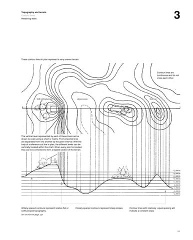
These contour lines in plan represent a very uneven terrain.
Contour lines are continuous and do not cross each other.
hill with plateau
depression
hill top
The vertical level represented by each of these lines can be drawn to scale using a chart or matrix. The horizontal lines are separated from one another by the given interval. With the help of a reference cut line in plan, the different levels can be vertically located within the chart. When every point is located, they can be connected to form a legible section of the terrain.
+ 5.00 m + 4.00 m + 3.00 m + 2.00 m + 1.00 m 0.00 m - 1.00 m - 2.00 m - 3.00 m
Widely spaced contours represent relative flat or softly sloped topography.
Closely spaced contours represent steep slopes.
Contour lines with relatively equal spacing will indicate a constant slope.
See section on page 150
99