AQUEDUCT AT PANIGHAT Tale of an ancient wisdom; turning from ruins to rubble By Debkumar Bhadra, Shore Point, Bambooflat, S Andaman and Dr TVRS Sharma, Principal Scientist (Retd), CARI, Port Blair
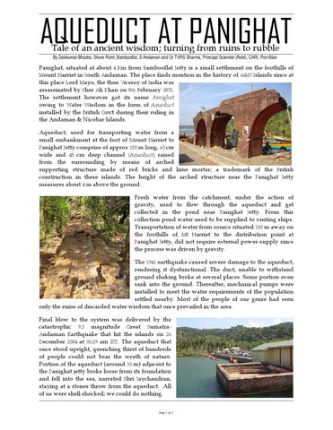
Panighat, situated at about 4 Km from Bambooflat Jetty is a small settlement on the foothills of Mount Harriet in South Andaman. The place finds mention in the history of A&N Islands since at this place Lord Mayo, the then Viceroy of India was assassinated by Sher Ali Khan on 8th February 1872. The settlement however got its name Panighat owing to Water Wisdom in the form of Aqueduct installed by the British Govt during their ruling in the Andaman & Nicobar Islands. Aqueduct, used for transporting water from a small embankment at the foot of Mount Harriet to Panighat Jetty comprise of approx 150 m long, 60 cm wide and 45 cm deep channel (Aqueduct) raised from the surrounding by means of arched supporting structure made of red bricks and lime mortar; a trademark of the British construction in these islands. The height of the arched structure near the Panighat Jetty measures about 4 m above the ground. Fresh water from the catchment, under the action of gravity, used to flow through the aqueduct and get collected in the pond near Panighat Jetty. From this collection pond water used to be supplied to visiting ships. Transportation of water from source situated 150 m away on the foothills of Mt Harriet to the distribution point at Panighat Jetty, did not require external power-supply since the process was driven by gravity. The 1941 earthquake caused severe damage to the aqueduct, rendering it dysfunctional. The duct, unable to withstand ground shaking broke at several places. Some portion even sank into the ground. Thereafter, mechanical pumps were installed to meet the water requirements of the population settled nearby. Most of the people of our genre had seen only the ruins of discarded water wisdom that once prevailed in the area. Final blow to the system was delivered by the catastrophic 9.3 magnitude Great SumatraAndaman Earthquake that hit the islands on 26 December 2004 at 06:29 am IST. The aqueduct that once stood upright, quenching thirst of hundreds of people could not bear the wrath of nature. Portion of the aqueduct (around 30 m) adjacent to the Panighat jetty broke loose from its foundation and fell into the sea, narrated Shri Jaychandran, staying at a stones throw from the aqueduct. All of us were shell shocked; we could do nothing. Page 1 of 2
Shri Jaychandran, recalls his father Late Dadulal, a freedom fighter along with three others were given settlement at Panighat in 1908 besides a stretch of the aqueduct by the British Raj. The aqueduct was functional then. He recounts, his father used to see ships calling at Panighat jetty to quenching its thirst. Though the 1941 earthquake destroyed the duct but the embankment survived and we get water from the same catchment even today for our day to day use. Seeing the perennial source, pipelines were laid by APWD (Andaman Public Works Department) to meet local water requirements. Those ships which once visited Panighat now turned to pumped water available from elsewhere. Shri Jaychandran further adds, some time before the 2004 Earthquake-Tsunami, the then Chief Secretary visited Panighat and interacted with the local population wherein he informed, the nallah with a huge catchment area of Mt Harriet is still alive and capable of meeting the local water requirements. Following the visit of the Chief Secretary, secondary forest growths over the aqueduct were cleared and painted but nothing else happened. During our visit to the aqueduct site in the month of April 2010, along with Dr TVRS Sharma (a retired agricultural scientist) and Shri Jaychandran, we were surprised the catchment which contained heavy silt deposits still contained water in it. Presence of water in the peak summer in the catchment, which is hardly 10 m deep and 30 m across indicates the source is perennial. It is ironical that a potential source of scarce water and the associated water wisdom have been replaced by power-intensive system. Re-erecting the aqueduct is something I have been dreaming for long. By doing so, we not only would save on Carbon footprint, but also could revive the history in its past glory observed Dr TVRS Sharma. The Archeological Survey of India (ASI) in its state level workshop under National Mission on and Antiquities held at JNRM Port Blair during 2-3 September 2010, acknowledged the need for documenting the aqueduct at Panighat which happens to be only second in the whole of India after Hampi. INTACH (Indian National Trust for Arts and Cultural Heritage) Port Blair chapter was urged to initiate a project proposal for conservation of the aqueduct. Monuments
As of now, the aqueduct at Panighat is in ruins and fast turning into rubble. Peoples residing nearby do not hesitate using the bricks to build their dwellings. If immediate conservation measures are not initiated, the structure would soon become non existent. The future generation will never know water wisdom ever existed in this part of the country. The effort by ASI to document the aqueduct is a welcome step. It now remains to be seen who wins “our efforts” to conserve the remains of the water wisdom or “the natural forces” that are eroding the aqueduct slowly, but steadily. The race is already on! Page 2 of 2