DAVID ROSSOUW
UCT School of Architecture Planning and Geomatics BLA hons (First Class), B.Arch(with distinction) | 2022

BLA(hons) (in the First Class)
BAS (With Distinction)
davidrossouw1999@gmail.com
(+27) 71-621-3170 - RSA
(+39) 340-199-9813 - ITALY
ARCHITECT’S
Landscape is a tapestry of interwoven historical, cultural, physical and biological processes that constitute a set of social values whereby people interact and inhabit the natural environment. The role of an architect is to acknowledge these processes and capture their essence in architectural space.
LANGUAGES
+ English
+ Afrikaans (Dutch dialect)
Mother Tongue
Mother Tongue
PROGRAMS SKILLS
+ Photoshop
+ InDesign
+ Illustrator

+ QGIS
+ Enscape
+ Revit
+ Autocad
+ Sketch-Up
+ Archicad
+ Lumion
2022
2021
2018 - 2021
2015 - 2016
+ Young Architects Competitions Academy & SANAA & WWF Workshop | Italy
Architecture for Landscape Higher Learning Course
+ University of Cape Town School of Architecture Planning and Geomatics| South Africa
Bachelor of Landscape Architecture (Hons) In the First Class (Top Student)
+ University of Cape Town School of Architecture Planning and Geomatics | South Africa
Bachelor of Architectural Studies (BAS) With Distinction
+ Cambridge University Assessment International Education | Cape Town Based AS Level English Literature certificate
2022
October
2022
January - September
+ Orizzontale Architettura & Unipol | Milan, Italy
Architectural Collaborator
Projects: “Re-interpretation”
Role: Collaboration with Orizzontale & Unipol on an E-Waste awareness initiative, which was an ‘on-site design and construct’ process with recycled materials.
+ Bomax Architects | Cape Town
Candidate Architectural Technologist - Design Team Member
Projects: Sancape (high end residential)
Role: Design and drafting team member focused on renovation and interior design. My role covered the first 5 architectural phases for the interior & exterior works contract.
2021 - 2022
Aug 2021 - Sept 2022
+ Kevin Kimwelle Architect (RDI and NGO Work) | Cape Town
Volunteer Architect - Part Time
Project: Waterfront Recycled Pavilion
Role: Collaboration on an experimental NGO project, focused on designing and constructing with reclaimed and recycled materials for the Victoria & Alfred Waterfront
2021 - 2023
October 2021 - Present
2021 Two Weeks
+ Podhaus | Cape Tow n
Collaborative Designer - Part Time
Role: Design Collaborator with Podhaus, a modular home company that seeks to design and build flexible, eco-friendly homes for clients in and around Cape Town (South Africa).
+ STARC Architects | C ape Town
Architectural Intern
Project: 190 Main Road, Muizenberg
Role: Site documentation and initial analysis phase drawings.
COMPETITIONS
+ Saint-Gobain Multi-comfort Student Competition
TERTIARY EDUCATION (UCT)
3rd Place in RSA Finals
+ OVP Associates Prize Top student in BLA(Hons)
+ University Class Medal
+ Cape Institutes for Architects Prize
+ Holm Jordaan Architects & Urban Designers
+ The Lisa Blane Memorial Prize
+ The Reuben Stubbs Award
+ Faculty Scholarship
+ Dean’s Merit Listing (3 consecutive years)
+ 82% GPA for Undergraduate Studies
Top Design and Theory ll Student
Top Design and Theory ll Student
Merit in Sustainable Design
Top Technology ll Student
Best project in Structure and Design
Engineering and Built Environment
Engineering and Built Environment Faculty

TYPE:

YEAR:
Memorial Intervention
2021
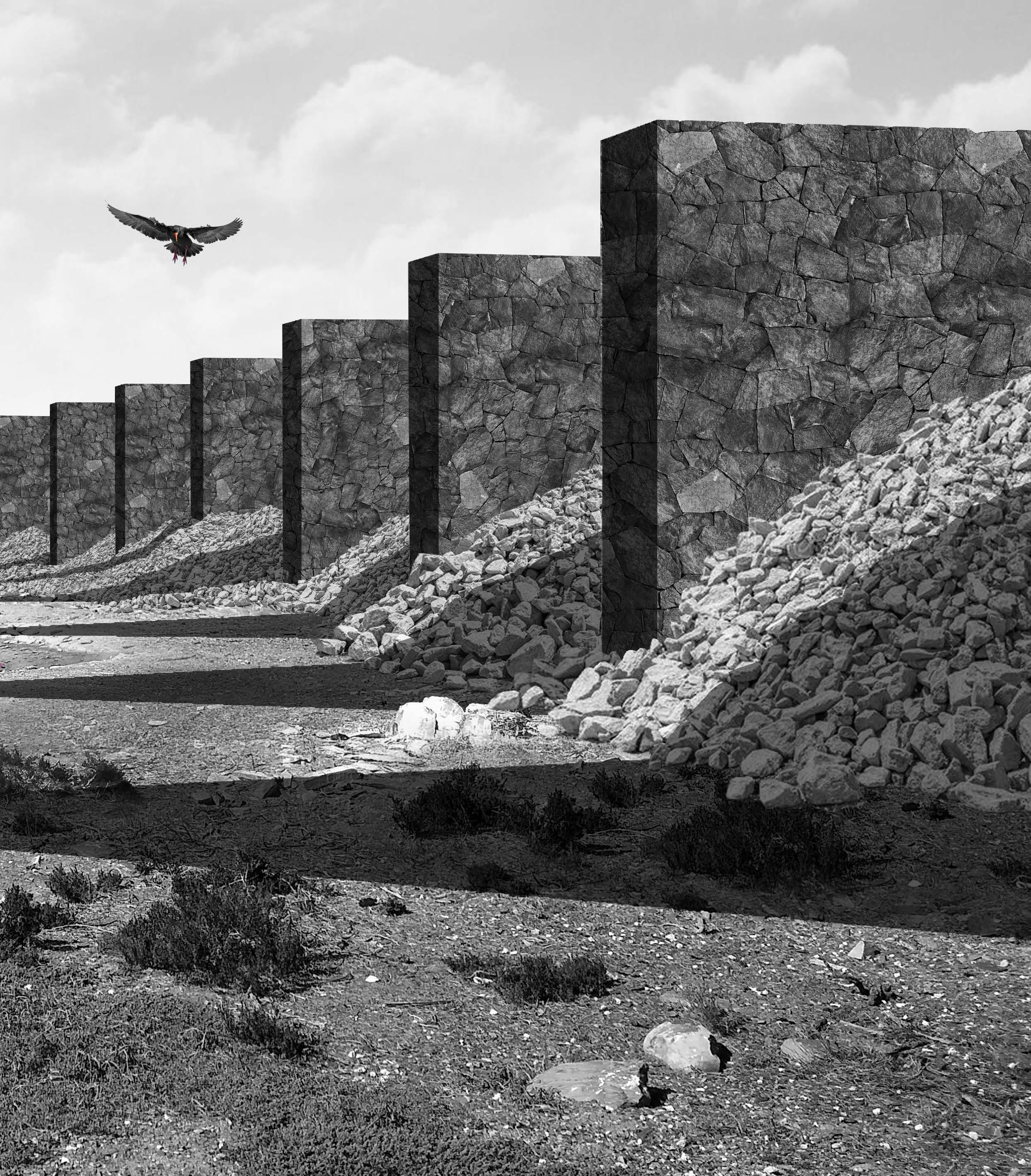
The blue stone quarry is located on Robben Island, where Nelson Mandela was imprisoned for 18 years. The stone from the quarry was used to build and maintain the prison buildings. Thus, the quarry was a symbol of oppression.
In recent years, there has been a call to rebuild the quarry wall, which prevented the ocean water from washing into the mining area. Rather than replicating the historical wall, this project serves as a


monument to the historical wall as well as the new natural processes that occur on the site, since the closing of the political prison.

Since the closing of the prison, the ocean has been able to wash away the historical wall, leaving only remnants. As the ocean water has been allowed into the quarry, the oyster catchers and penguins have made it a new
habitat for swimming and breeding. Since there are no oysters found in the quarry water the faeces produced by the birds have caused a rise in micro-organisms that during warmer months turn the water pink. This event


is an expression of the new biological processed that are found on the site. The wall monument was designed to allow for ocean water to wash into the quarry, while still memorialising the historical significance.

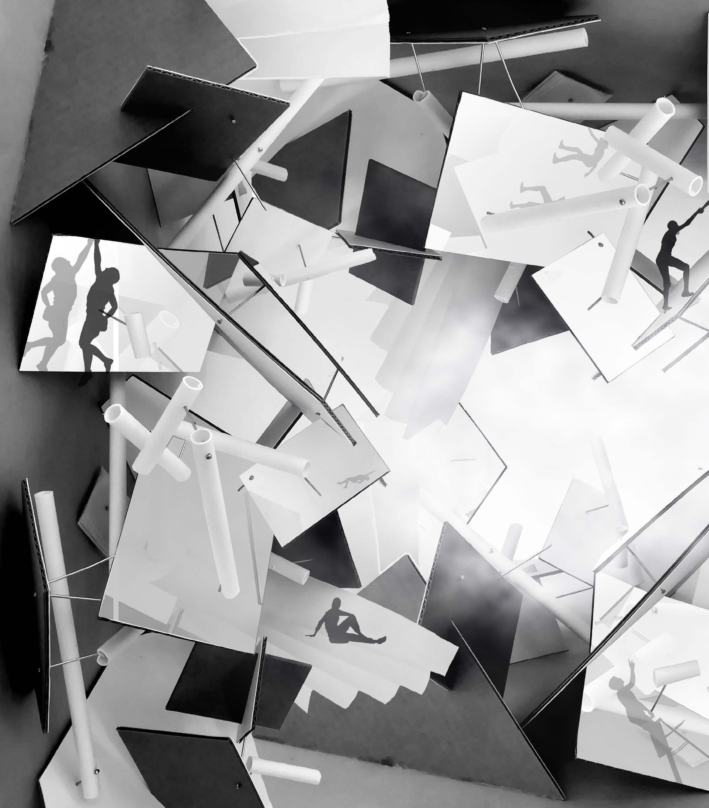
The from was developed through a creative process that used a series of model making exercises and drawing exercises to interpret the experience of the site. The accompanying models are expressions


of associated emotions. when visiting the site. The project called for a way to inhabit the quarry to view the historical wall and changing colour of the quarry without disturbing the oyster catcher’s habitat.
The solution was to have intersecting ribbons, that responded to the topography and form of the historical wall. These ribbons formed the new monument walls and a defined walkway for people to inhabit.

PACKED WALL (reflecting historical height)

WASHED WALL (allowing ocean water into the quarry)

A cultural practice when visiting Robben Island is to add a stone to rock piles created by previous visitors. These piles , known as “Isivivane Soluwasse” serve to remind visitors of the collective struggle of Apartheid.
The stone piles are allowed to to form between the monument walls, keeping the cultural practice to stay alive. The piles can be washed away by the ocean, the same way, the historical wall used to be washed away.
After the piles are washed away, the visitors can slowly over time rebuild them, just as the island prisoners used to do. The wall therefore, has a dynamic nature that responds on a historical and biological front.

OBSERVATION OF QUARRY


OBSERVATION OF OCEAN


COMPETITION:
TYPE: YEAR:
POSITION:
Saint-Gobain Multicomfort Contest

Urban Park Scheme
2020
3rd place in RSA Finals
The site in Saint-Denis, France houses the world’s oldest steel reinforced concrete building. In light of the 2024 Olympics, the site has been identified as key to future urban development. The Multi-comfort SaintGobain competition required the designing of an urban park in anarea of increasing density.
Accompanying the park, the brief required 250 to 300 residential apartments, a school and a community centre to activate the post-industrial area. Parc Du Ciel is a proposal that contends densifying urban space by grounding the sky into the park. The scheme sets itself to order to preserve the openness
of the park and lay emphasis on the historical buildings on the site. It further proposes a reconnection strategy between historical nodes in the SaintDenis area that has been interrupted by a railway system.
 Saint-Denis Canal Railway Crossing
Renovation of Warehouse Coignet Maison Preservation
Views of the Basilica Cathedral of SaintDenis
Saint-Denis Canal Railway Crossing
Renovation of Warehouse Coignet Maison Preservation
Views of the Basilica Cathedral of SaintDenis
DE-DENSIFICATION

Reflective Greenhouses
STRUCTURE


The Supported and Supporting
LANDSCAPE STRATEGY

Landing
HERITAGE PRESERVATION
Focused Nodes

The residential circulation access sits within the greenhouse, providing private green spaces for residents to grow produce for themselves as well as to be sold at the green market located in the re-purposed warehouses.
The greenhouse structure captures rainwater, integrating it into greenhouse irrigation and residential water systems. The residential units give stability to a more independent steel greenhouse structure. Finished
with a tinting double glazed, SageGlass, the greenhouse becomes more reflective on the outer face in direct sunlight, masking the hidden built forms from park dwellers and creates privacy for the residents.

Internal Powerpoints


Electrical Car Ports


Artificial Lighting
Solar Power
Commercial Zone
Flushing Water


Bathing Water
Hot Water System

Groceries

Greenhouse Plants

Greenhouse Water
Overflow Water
Natural Rain Water


Water Treatment


Accompanying the urban park proposal, was a requirement for 250 to 300 residential apartments, that have access to the park themselves. It was crucial to


blocks to inhabit the park while still keeping the area open and pleasant. The apartments were arranged into L-shaped structures
for the historical buildings in the area and to mask the surrounding industrial area while in the park. For the inhabitants, it was crucial

Parc Du Ciel proposes the use of electro-chromic laminated IGU, double glazed SageGlass for a greenhouse space that regulates the comfort levels of the
spaces. The project was designed using the products offered by Saint Gobain. A requirement of the competition was to achieve a specific energy efficient class in
order to become a viable option . All calculations were done using the Saint-Gobain Multicomfort calculation software.


HEATED SPACE AREA & VOLUME CALCULATIONS

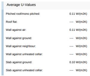

ENERGY EFFICIENT CLASSES
ENVELOPE - Opaque elements
ENVELOPE - Windows & Doors


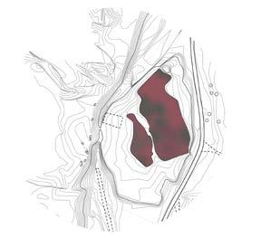
This project framed the syllabus for a Landscape Systems Analysis course. The project focused on understanding the natural and human systems that define the landscape of Noordhoek, South
Africa. Using the analysis of these systems, a design proposal was put forward to correct or improve on the landscape’s performance. A narrative of fire risks in the Noodhoek basin uncovers how


TYPE: .
NOORDHOEK, CAPE TOWN, SOUTH AFRICA
DURATION:
YEAR:
the lay of the land allows for a veld fire system that puts the local mountain users at risk. This project intends to identify at risk areas in Noordhoek and propose a strategy to contend fire damage.
Landscape Site Analysis and Systems Proposal
12 Week course 2021


The Noordhoek basin forms part of the Cape Fold Belt which saw the African Tectonic Plate press into the Great African Plateau to form the mountain range. An
analysis of the grain of the land reveals how land-form plays a key role in the spatial arrangements of other natural systems in the basin. The basin experiences


chemical erosion which causes for harder geological material to be on the higher relief parts and softer materials towards the bottom of the basin.

Previously Bellow water (1,5 Million Years)
Most Prominant Peaks
10m Contours
60m Contours

Investigation Area
Winter Winds
HOUT BAY
M2
Silvermine
Nature Reserve
Chapman’s Peak
NOORDHOEK
KOMMETJIE
M2


The Noodhoek area is accessible via only four roads, each coming form a different part of the peninsula. As a result of this, the area is very isolated from the rest of the Cape Town Metropolitan
Area. Further investigation, shows that each of these access routes sit within the fire risk zone, meaning that emergency response teams would struggle to access the basin during a time of

fire crisis. The lack of road access is a result of the geological relief of the mountain. If one road were to be closed, the next access road would require a far detour around the mountain.


Ecotopes are the smallest ecologically distinct landscape features in a landscape classification system. These ecotopes were derived through
overlaying mesotopic, hydrotopic, biotopic and anthrotopic layers over each other. Information layers that dealt with veld fire were used to identify parts of the
basin that were of higher fire risk. This study uncovered that the higher parts of the basin are of a greater fire risk, while the middle relief, holds the least risk.


This proposal attempts to improve on the existing bush fire emergency support systems in hopes of creating a safe environment for mountain users that does not compromise the natural landscape. The first strategy focuses on the

reintroduction of the fire break ring which was first introduced in 2004 by the Table Mountain National park Fire Management Plan. The second strategy sees to that people caught on the mountain have access to fire bunkers which will allow them
to wait out rescue if they are unable to get off the mountain. The last strategy is to propose a location for a fire station within the basin itself, allowing for emergency response times to be more efficient.
PROPOSED FIRE BREAK AND BUNKER NETWORK

Proposed Elements
Proposed Fire Station Location
B
Proposed Fire Bunkers
Proposed Firebreaks
Access Road Firebreaks
Existing Elements
Existing Fire Stations
Existing Firebreaks
Main Access Roads
Mountain Trails
At the core of successful modular design, is the ability of the object to compliment the landscape it finds itself in, yet reaps the benefits of easily replicable forms. The concept for this
segmented pod was developed while working with Podhaus. The sustainable luxury housing business attempts to introduce a surprisingly customisable module into the highly diverse landscapes
of Southern Africa. Through an adaptable form and choice of cladding, this pod can mimic the language of its surroundings, giving rise to successful cohabitation.

BUSINESS:
TYPE:

YEAR:
Podhaus
Modular Housing
2022
SOSSUSVLEI, NAMIBIA


NEWLANDS FOREST CAPE TOWN
SOUTH AFRICA
SOUTH AFRICAN PINE
TIMBER CLADDING


The form of the adustable segments required a strategy that adapted to each unique location, while enhancing the experience of the internal spaces of the modular home.
The solution was to allow for an envelope that “kinked” outwards in strategic directions. The kinks would allow for larger internal spaces while providing views outwards through the
key placement of windows and clerestories. These windows allow for sun to penetrate the home according to passive heating and cooling requirements.
The modules are steel frames with timber stud walls. The basic frame remains the same for the various locations, while the external cladding adapts to

match or compliment the colours and textures of the landscape. The segments are prefabricated at the Podhaus premesis. From there they are carried to the sites.
Upon reaching the site, the segments are fixed together. Following this process, the home recieves its waterproofing and finally the external cladding.

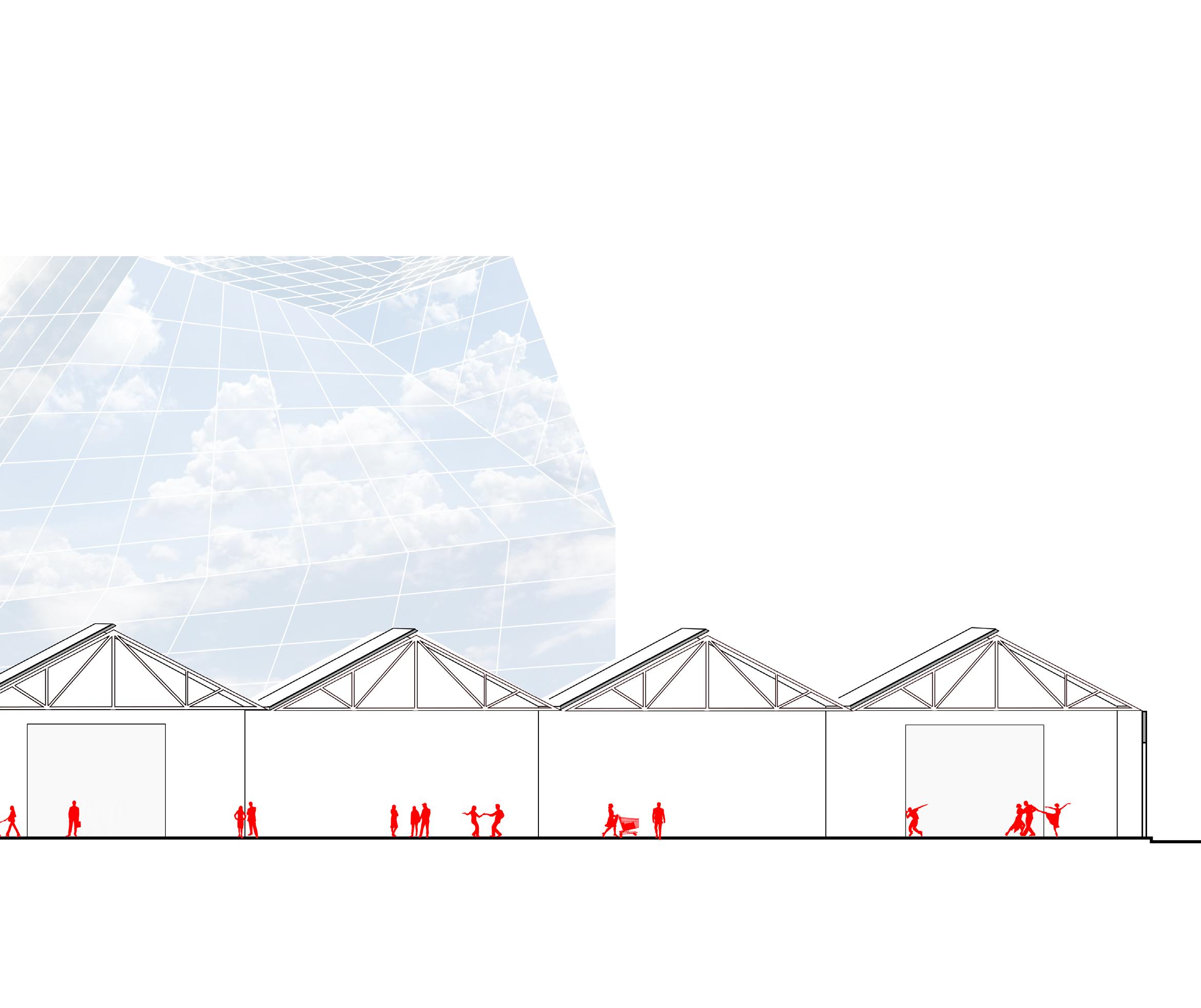
TYPE:
Cultural Hub

YEAR: BLACK RIVER PARK, CAPE TOWN, RSA
2020
To achieve light and sensitive interactions between the landscape and the architectural intervention, three edge concepts were used in the design process.
The first strategy was to allow for more visible and less visible parts of the museum , using increasing spacings between slats and structural elements. The structure


also would extend and “unravel” into the landscape. The last edge strategy was to allow for the greenery in the landscape to coinhabit the structures.


When dealing with disappearing edges, it was necessary to find a strategy that would help visitors navigate through the museum. The solution was to create prominent and more visible cores.
The programmatic spaces were arranged around these cores and would allow for people to walk from a dark to a light edge. To achieve this effect, it was crucial to design in section.
A model exploration process became crucial in understanding the heirarchy of spaces and the interfaces between the cores, edges and the landscape which they inhabit.


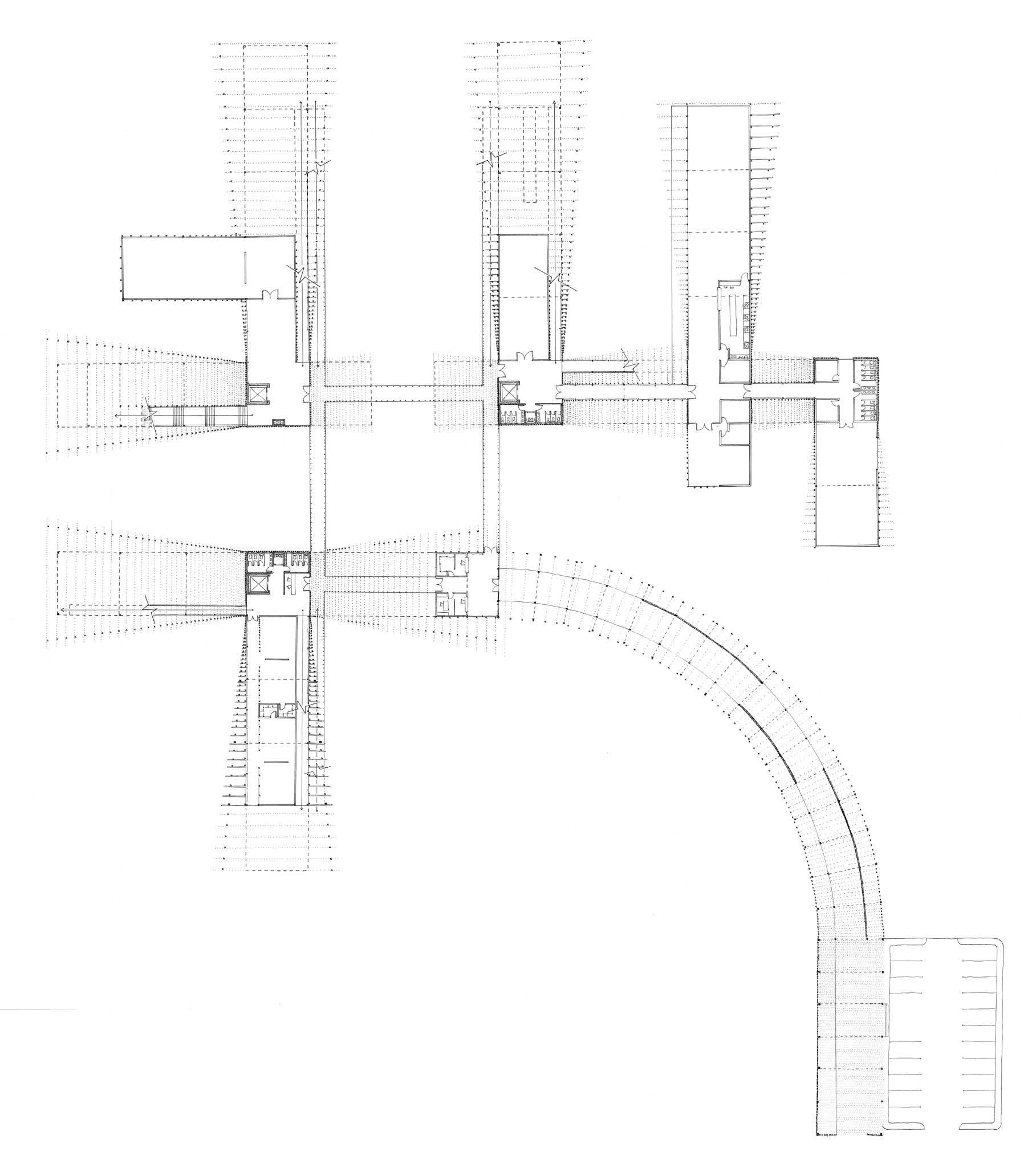


A challenge in this project was to achieve light and thin structures with larger spans. The technical strategy to achieve the disappearing was to make use of a series of flitched beams that
are made stronger through fixed steel plates. The structural footings or foundations are driven piles with steel inset sections that connect the structural columns with the foundations.


A crucial consideration were the plants incorporated in the reflective pools. These plants were all indigenous water sensitive plants that helped filtrate the water below the structures.

Freylina Lanceolata
Wachendorfia Thyrsiflora


Cyprus Textiles
Zantedeschia
Aponogenton Distachyos
Knophofia

Linearifolia


Aethiopica
Thatching Reed


Menlianthus Major