
Portfolio 2024 COCO WANG

Coco holds an Honours Bachelor of Arts in Urban Studies from McGill University and is currently completing her Master of Landscape Architecture at the University of Toronto. Her professional background spans roles in Landscape Architecture research and design, alongside Urban Design, Planning, and Urban Development Consulting. Coco’s professional interests are focused on unraveling the potential of public space design to mitigate climate change, strengthen community relationships, and promote active living. She hopes to contribute to the development of resilient, equitable, and vibrant cities through her professional practice.
CONTENT
ELASTIC LANDSCAPE
STUDIO - Neighbourhood Park Design
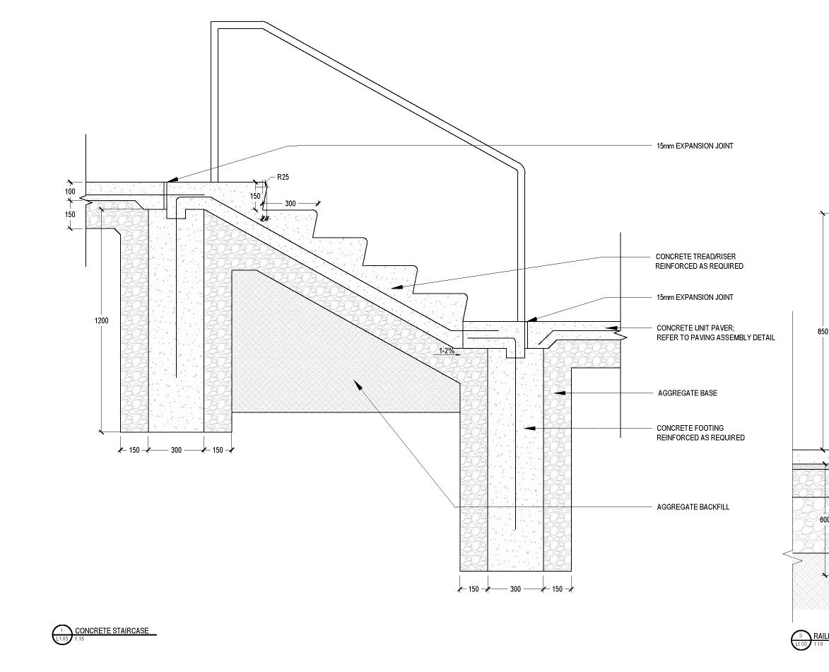
LANDFORM DESIGN
Grading and Details
MEASURING LANDSCAPE
STUDIO - Parametric/Generative Design
INVESTIGATIVE LANDSCAPE
STUDIO - Indigenous History
EQUITABLE RESILIENCE IN TORONTO’S OPEN SPACES
Landscape Research
GRADIENTS OF RESURGENCE
STUDIO - Landscape Masterplan

ELASTIC LANDSCAPE A FLOODABLE NEIGHBOURHOOD PARK
SOFTWARE | AutoCAD, Illustrator, Photoshop, ArcGIS
ACADEMIC | In Collaboration with Izzy Mink
PROJECT CONTRIBUTION | mapping analysis, design development, CAD plan, enlargement rendering, zoomed-in plan, details, grading, planting plan
DATE | Jan - Apr 2023
This project aims to enhance Smythe Park’s role in serving the diverse needs of its residents, particularly those in equitydeserving groups, by addressing issues like flooding, lack of inclusive programming, and accessibility.
Through the elastic approach, we introduced flexible and inclusive recreation spaces that have varying functions based on water levels. These spaces, such as the “multi-use staples” , the “flexible active hardscape”, and the “amphibitheatre”, facilitate as important community anchors while also are able to remain functional during flooding events.
Ultimately, this design seeks to harmonize social use with environmental challenges, serving as a model for functional floodable parks that cater to community needs while adapting to climate change impacts.


350 YEAR STORM 100 YEAR STORM 25 YEAR STORM 10 YEAR STORM 5 YEAR STORM PERSCRIBED PROGRAMMING SITE ANALYSIS

AVERAGE USE TIME


50% OF THE POPULATION ARE IMMIGRANTS, WHICH IS 5% HIGHER THAN THE 45% MUNICIPAL AVERAGE

AVERAGE HOUSEHOLD INCOME IS $57K, AROUND 27% LOWER THAN THE $78.5K MUNICIPAL AVERAGE

47% IDENTIFY AS VISIBLE MINORITY - BLACK, LATIN AMERICAN AND SOUTHEAST ASIAN POPULATION ARE OVERREPRESENTED.
DESIGN DEVELOPMENT


WIDENED CIRCULATION
Stitching all the programming together is a widened path accomodate more visitors. The promenade connects the park the east and the west entrance.

WETLAND
The intimate secondary path takes visitor through the more naturalized areas of shallow wetlands and successional savannah
terracing
CIRCULATION
programming that can The shared park from entrance.
DETENTION PONDS
The east side of the park is the center of recreation and social gathering, with opportunities for large group activities. The flexible active hardscape and multiuse active field both double as detention ponds to accomodate flood.
AMPHIBITHEATRE
An intimate “amphibitheatre” surrounded by woodland, functioning as an outdoor classroom, fire circle, and can hold runoff from the surrounding neighbourhood

FLOODABLE LAWN + CHANNEL ACCESS
In the only flooded area south of the channel, we embraced high water by introducing a floodable lawn with terracing that leads down to the creek.
ADVENTURE ZONE + SWIMMING POOL
The main activity area includes a new concession, changeroom, washroom, as well as permanent barbeques and an abundance of seating areas for large group gatherings
PLAZA
The park draws in visitors with a new street-level plaza on Jane, connecting the park and the public realm, and providing a more welcoming entrance at one of the two key bus stops.
ACCOMODATING FLOOD
This design maintains a channelized river as flooding cannot be resolved at this limited scale. This allows for more space allocated to diverse programming. In fact, this scheme actively promotes social engagements along the channel, incorporating crossings, bridges, and shade sails to activate the space.
The east side of the park is the center of recreation and social gathering, with opportunities for larger group activities. The layout of this new programming responds directly to the existing flood patterns. It maximizes the potential uses of each feature based on its relationship to water and the shifting seasons.


DETAILED
HOT SUMMER DAY EVENING FESTIVAL HIGH WATER WINTER

DETAILED CAD PLAN
ADVENTURE ZONE DETAILS
An Adventure Zone sprawls across a rolling topography, encouraging play and physical activity for children and adults alike. A strategic planting plan creates a playful visual and physical buffer between the Adventure Zone and the channel’s edge.


 ADVENTURE ZONE BUFFER PLANTING PLAN
 MINK
MINK
MODULAR POOL FENCE
Our design took a new take on the required fence enclosure around the pool. This fence is multifunctional with modular inserts including solar panels, magnetic games, community notice boards, and tower storage. The rest of the panels are perforated to reveal an aerial of the pre-channelized Black Creek.


CONSTRUCTION DETAIL FOR MODULAR POOL FENCE
PERSPECTIVE RENDERING BY IZZY


FLOODABLE HARDSCAPE

ACTIVATING THE CHANNEL VARYING FLOOD LEVELS
As there’s limited flooding high water is embraced through of a floodable lawn with creek. The channel is strategically an expanded platform that retention and deceleration. into a vibrant civic space, community events like concerts, local protests.
Flexible multi-use staples the channel, capable of adapting levels. These staples can including the use of a screen the deployment of shade sails during high flood events. ensures adaptability and resilience, into a responsive and dynamic
HARDSCAPE + SOFTSCAPE

CHANNEL DURING LEVELS
flooding south of the channel, through the introduction terracing leading to the strategically opened, creating that serves both as water deceleration. This area transforms accommodating diverse concerts, movie nights, or staples are integrated along adapting to various water be activated differently, screen for movie showings or sails that can be removed events. This thoughtful design resilience, shaping the park dynamic landscape.
 CONCEPT MODEL: 3 LEVELS OF WATER

LANDFORM DESIGN
TOPOGRAPHIC GRADING EXERCISE
SOFTWARE | AutoCAD
ACADEMIC | In Collaboration with Xushan Liu
PROJECT CONTRIBUTION | site design and grading (independent), details (collective), model (collective)
DATE | Dec 2023
Working in pairs, this project tasks us to explore complex landform in a precise grading design with clear design documentation in AutoCAD. The primary challenge involves safely directing people from the top of a steeply sloping site to a promenade along the waterfront.
I designed a geometric landform with an accessible ramp that takes visitors down multiple planted viewing platforms, with careful consideration of walking experiences and water drainage. I took on the overall design of the landform, the grading plan and layout plan, while my partner and I worked on the details and the model together.
LAYOUT PLAN

GRADING PLAN

DETAILS


 LASER CUT TOPOGRAPHY MODEL


MEASURING LANDSCAPE
GENERATIVE DESIGN IN LANDSCAPE ARCHITECTURE
SOFTWARE | Rhino, Grasshopper (Wallacei, Plant Kit, Lands Design, LadyBug), TwinMotion, MidJourney, LooX.AI, ChatGPT
ACADEMIC | In Collaboration with Xushan Liu
PROJECT CONTRIBUTION | concept design, grasshopper script development, 3D modelling, rendering
DATE | Sept - Dec 2023
Generative design utilizes computer algorithms to rapidly explore and create diverse design solutions by inputting parameters and constraints. Common in architecture but new to landscape, it enhances creativity by swiftly iterating possibilities, balancing multiple and often conflicting goals from various stakeholders.
Using parametric and generative design tools, this project envisions a public plaza integrated with Toronto’s film industry located in the Lower Don Lands. The design optimizes for stormwater holding capacity, planting, recreational space, commercial activity, energy production and consumption.
The script produced over 39 trillion design solutions and we picked the top 3 based on specific criteria.
The project is located at the Portlands, focusing on parcels just West of Cherry Street as it boasts the best view of the Toronto skyline of the entire site. The site is deeply connected to the film industry, with several major studios, including Netflix, located in the lot.

Considering the interests of the general public, local industry, and the Urban Forestry department, we identifying 6 main project objectives that will be balanced using genetic algorithm.
• Maximize planting area
• Maximize projection area
• Maximize seating area
• Maximize solar panel
• Maximize stormwater storage
• Minimize cut & fill volume


SITE ANALYSIS
DESIGN CONCEPT
We designed two mound typologies to create a more intimate space, which are placed throughout the site.

1.DETERMINE BOUNDARY
Determine the programming area that will be populated with the 2 typologies.

4.SELECT LINES
Half of the lines becomes mounds, while the other half becomes ridge-lines.

1.Projection Mound = solar + projection + seating

2.Passive Mound = stormwater pond = planting hill

2.GENERATE VECTOR
Randomly generated lines (vector) that drives the different design iterations.

5.ASSIGN TYPOLOGY
0 - 45 degrees = Projection Mound 45 - 90 degrees = Passive Mound

3.CREATE VECTOR FIELD
The vectors then create a field with lines forming different patterns.

6.MODIFY TOPOGRAPHY


From the 39 trillion possible iterations, 3 of the top performing iterations were chosen for final comparison.
ITERATION 1

ITERATION 2

ITERATION 3


ITERATION 1
The first iteration has the best average result for all 6 goals, excelling in minimizing the cut and fill difference.


ITERATION 2*
The second iteration was chosen for its interesting pattern. It prioritizes the environmental objective by placing more Passive Mounds on site, but does not perform well in cut and fill minimization. This concept was chosen as the final design for its unparalleled walking experience.


ITERATION 3
The third iteration also tries to balance all objectives, but prioritizes the social objectives by placing more projection mounds.


INVESTIGATIVE LANDSCAPE
MAPPING THE ORIGIN OF TKARONTO
SOFTWARE | Illustrator, Rhino, ArcMap
ACADEMIC | In Collaboration with Xushan Liu
PROJECT CONTRIBUTION | research, mapping, site plan
DATE | Feb 2022
In this project, my partner and I posed as “Landscape Detectives,” using visual and literature analysis tools to fill in the gap of some of the most important Indigenous history in our province. We were interested in the story of our city’s name, Toronto, which originates from the Mohawk word, Tkaronto, translated as “a meeting place” or “where trees stand in water”. The origin of the name is traced back to the Atherley Narrows, a body of fast moving water which connects between Lake Simcoe and Lake Couchiching, and is home to the Mnjikaning Fishing Weirs which were used by many Indigenous nations for thousands of years.
Using ArcMap and Illustrator, I created the two maps which serve to contextualize Indigenous trade routes that shows the connection between Lake Simcoe and Toronto. Through site analysis and literature review, I also visualized the configuration of the fishing weirs, which was the first time this lost story was illustrated. In addition, I constructed the 3D Rhino model of the site using bathymetry and topographic data, which was used as the base for the physical CNC-milled model.
TKARONTO WHERE THE TREES STAND IN THE WATER.
The Narrows held many names - When this area was originally inhabited by the Huron-Wendat people, they called Lake Simcoe “Ouentaronk”, meaning beautiful water. After the Hurons were driven out in the 1650s, the Iroquois Confederacy including the Mohawk people moved to this area, which is when the word “Tkaronto’’ was used for the Lake, with various spellings, such as Taronto with an “a”, a name adopted by the French settlers for a while. To the French settlers, Lake Simcoe was also known as Lac aux Claies, meaning the Lake of Hurdles or the Lake of the Fish Weirs (General John S. Clark, 1899, AARO 1900:195). Towards the end of the 17th century, the Ahnisnabe people migrated to the area and the Narrows was given another name - Mitchikan, meaning fence, enclosure, and hedge.
As detailed by Indigenous Scholar Fred Martin, the ancient routes connect from Lake Ontario to Lake Simcoe through Humber River, Don River, and Rouge River, as well as through trails including the Carrying Place Trail and Davenportage. Twice a year, the Narrows become a place of gathering, exchange, ceremonies, hosting the Creator’s power and spiritual energy.


The Narrows’ name was derived from the oldest and only wooden fishing weir still in existence in Canada, named the Mnjikaning Fishing Weir, dating back thousands of years. It provided its many inhabitants with an abundance of fish throughout history, such as walley, pike, sucker, and sturgeon. As first documented by French Explorer Samuel de Champlain in 1600s, each year in the spring and in the fall, indigenous peoples would travel across rivers and portage trails with their family to gather at the Mnjikaning Fishing Weir, their ancestral fishing camp.


A study by Johnston and Cassavoy in 1978 contributed heavily to our understanding of the Mnjikaning fishing weir. Their study found 535 stakes that remained in the Narrows, some of which form pilings visible from the surface, as well as many that were scattered at the bottom of the channel.
They theorized from the patterns of the remaining stakes that there used to be several fences that span across the entire strait, leaving only small openings which guide the fish into shallower areas. In our plan and our model, we plotted the locations of the piling that still exist today as well as fences that were theorized to exist based on remains and writings: This pair left a small opening and could trap the fish swimming with the current towards the warm and shallow Lake Couchiching. And another set in this diagonal direction which catches fish that swam upstream towards colder and deeper Lake Simcoe. These three fishing weirs combined a perfect trap to catch fish from different directions, and we can expect repeating fences to capture as much fish as possible that could last them for months.
Although the Narrows continues to be an important site to Indigenous members who routinely use the site as an integral part of their regular Sunrise Ceremonies, many of the site’s history was overshadowed by the construction of the transCanada Hwy 12, which cuts directly through the Narrows, causing many of the original stakes to be removed.

The visualization of the Atherley Narrow’s historical fishing weir, a pivotal site for Indigenous peoples and Toronto’s history, represents a groundbreaking effort to illuminate the pre-colonial landscape and its significance, marking the first comprehensive portrayal of this crucial aspect of Indigenous history and heritage.

EQUITABLE RESILIENCE IN TORONTO’S OPEN SPACE
SSHRC Research Partnership Project
SOFTWARE | InDesign, ArcGIS Pro, Illustrator
CENTRE FOR LANDSCAPE RESEARCH | Led by Fadi Masoud
PROJECT CONTRIBUTION | team lead, project planning, GIS spatial analysis, research compilation in InDesign
DATE | Sept 2022 - present
This research project seeks to understand current barriers to achieving good quality public parks in Toronto, and explore opportunities to improve access, functionality and resilience of those parks for Toronto’s residents. Specifically, this research calls out the often underfunded and overlooked neighbourhood parks as critical infrastructure, centering them as the solution to enhance social equity and environmental resilience in Toronto.
My role is to lead the research team in developing a methodological framework for the Toronto Park, Forestry and Recreation Department. My contributions include: literature review, high level data overlay and mapping, as well as the compilation of all research finding for comprehensive report.
In May 2023, I represented the team in presenting the research findings at the annual conference in Calgary.
STUDY AREA SELECTION
This research began by defining “quality” in a small study area strategically chosen through mapping exercises, specifically targeting areas in Toronto with environmental, infrastructural, and social challenges.


OVERLAY ANALYSIS ON STUDY AREA
I overlaid a selection of physical, social, and environmental data to identify possible sites of intervention. These sites within the study area exhibit a high degree of vulnerability and opportunity based on the intersection of various parameters such as environmental conditions, physical/infrastructure, socio-demographic information, land values, and land use. This method combines multiple definitions of “quality” and begins to identify potential design action areas for further inquiry.


PARK TYPOLOGY


LAYERS OF MANAGEMENT
Zooming in from our spatial analysis, we explored the management structures that operate within park spaces as a way to understand the quality of maintenance practices. Toronto parks operate with an annual budget of $190 million dollar, split between the organizations figured below.
CATALOGING ELEMENTS
We conducted an inventory of elements in public parks found within the Black Creek Subwatershed. This cataloging exercise identified a limited palette of elements used to populate parks within the study area. Within the same category of element, we also found little to no diversity in design.
 PARKETTE
COMMUNITY PARK
DISTRICT PARK
PARKETTE
COMMUNITY PARK
DISTRICT PARK

GRADIENTS OF RESURGENCE
EMBRACING THE GIFT OF HIGH WATER
SOFTWARE | Illustrator, Photoshop, Rhino, ArcGIS
ACADEMIC | In Collaboration with Izzy Mink, Fernanda de Carvalho Nunes and Molly Lalonde
PROJECT CONTRIBUTION | mapping analysis, strategy development, design of school and community interface
DATE | Sept - Dec 2022
One of Toronto’s biggest concerns in preparing the built environment for climate change is flooding. As extreme and sudden cloudburst events become more frequent, Toronto’s stormwater infrastructure will be put under greater pressure, resulting in more catastrophic damage from flash flood events.
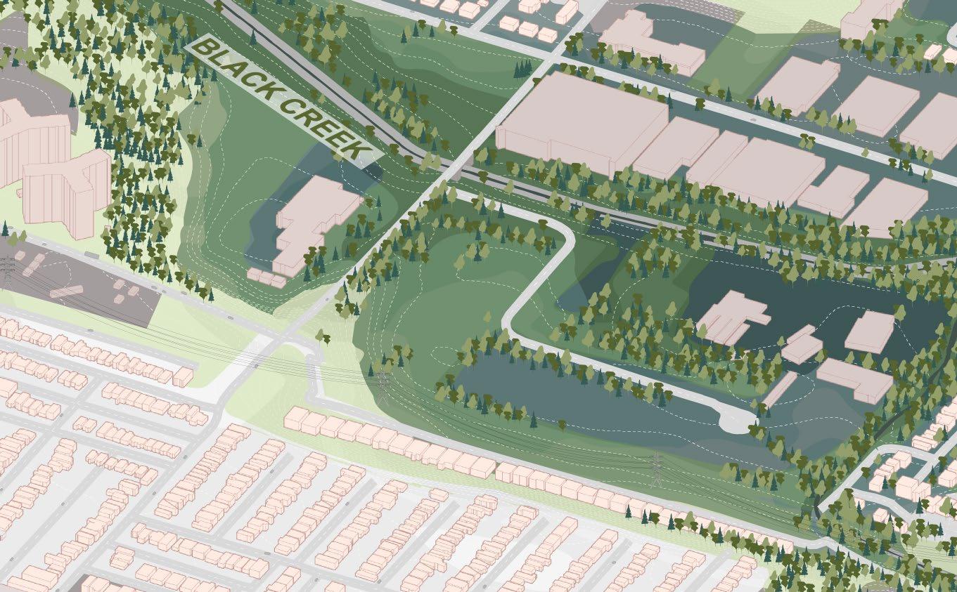
Rockcliffe-Smythe, where the channelized Black Creek meets the Humber River, experiences severe flood damage and has limited financial capacity to address these issues.
This project envisions a landscape-first strategy, dechannelizing the river and turning it from a point of distress to a point of pride.
SITE SELECTION
The first step in the project was defining a design location based on climate vulnerability and social equity. This process led us to the Rockcliffe-Smythe


WATERCOURSE + FLOODPLAIN

LANDSCAPE ASSETS
COMBINED SEWAGE (CSO) + TREATMENT PLANTS
PARKS + OPEN SPACES
DEMOGRAPHIC DATA

FINAL SITE SELECTION


SITE ANALYSIS
The site analysis found 3 main problems persisting in the Rockcliffe-Smyth area:
• Severe flooding due to channelization and undersized bridges;
• Poor water quality due to industrial land use and impermeable hard surface;
• Underutilized public spaces due to rear-facing housing layout and limited cross-creek connectivity.
STREET HIERARCHY & TRANSIT LINES
AREA
OF COMMUNITY CONCERN
NEW DEVELOPMENTS


PROPOSED DESIGN
DESIGN STRATEGIES:

1) REHABILITATE THE RIVER
Dechannelize Black Creek, widening the river bank for meander, which reduces flood risk in surrounding areas.

2) STRENGTHEN PUBLIC SPACES
Expansion of green space along Black Creek through downzoning areas of high flood-risk, increases public access to the river

3) REDEFINE THE EDGES
Reorienting the community towards the river. Densification along the edges of the river and along major north-south transit corridors.
CALL OUT 1: ROCKCLIFFE COURT
EXISTING
CALL OUT 2: COMMUNITY INTERFACE
I took on designing the connection between the creek and its surrounding environment, including strategies for the local school, the streetscape, and mid-rise housing to promote a stronger sense of the public realm.

CALL
OUT 3: MULTI-USE BRIDGE

PROPOSED


SCHOOL
The secondary school adopts strategies to reduce runoff and protect the neighbourhood from severe flooding, including green roofs, increased permeable surfaces, and rainwater harvesting storage.
DRY POND
The parking lot becomes a dry pond that can hold over 6000 cubic meters of water during storm events. In the winter, the dry pond freezes over, and is transformed into a community skating rink.
EMERGENT MARSH
Black Willow Salix nigra
Pondweed Potamogeton spp.
Bluejoint grass Calamagrostis canadensis
Cattail Typha Angustifolia
Horsetail Equisetum arvense

SUBMERGENT MARSH
Coontail Ceratophyllum spp.
Duckweed Lemna minor
Waterweed Elodea canadensis
Spatterdock Nuphar lutea
Waterlily Nymphaea odorata
Dechannelizing allows river its velocity flow

COMMUNITY INTERFACE

MEANDER BELT
Dechannelizing Black Creek allows for a larger area for the river to meander, decreasing velocity and allowing a larger of water to run under the bridges
SHARED STREET
These larger public streets with limited car access will become extensions of the park, improving access to the water, and providing opportunities for residents to get to know their neighbors.

NEIGHBOURHOOD COMMON
Plazas in front of the midrises act as a neighbourhood common for nearby residents as well as a center of activities that attracts the secondary school students across the river. The re-orientation of these buildings now all front towards the river which promotes more intimate interactions with the landscape.
RESIDENTIAL MIX-USED MID-RISE
Many existing single-family houses that back onto the park are bought out and transformed into denser forms of housing stock. These include compact-walk ups along Black Creek, 6-storey midrises along main streets; and 12 storey mid-rises at major intersections.

INTERFACE

Stormwater Retention + Community Activation

Environmental Education
*Each member of the team completed one perspective render.
WINTER DRY POND
LANDSCAPE LITERACY

REUNION POND
Water Filtration + Public Space Creation

COMPACT WALK-UPS
Densification + Community Activation

