TOMORROW’S VERTICAL URBANISM: 25 DESIGNERS SHARE THEIR FUTURE PROJECTS
A QUARTER OF A CENTURY ON: THE REBUILDING OF THE WORLD TRADE CENTER
PLUS TOKYO, BANGKOK, LOS ANGELES, SAN FRANCISCO, HONG KONG & PORTO ALEGRE
Publisher
Vertical Urbanism is published by the Council on Tall Buildings and Urban Habitat (CTBUH).
ISSN: 2997-9463 (Printed)
ISSN: 2997-9471 (Digital)
Editorial
Editor-in-Chief:
Daniel Safarik dsafarik@ctbuh.org
Executive Editor: Will Hunter will@will-hunter.com
Managing Editor: Martina Dolejsova
Associate Editor: Javier Quintana de Uña
Advertising: Jody Cranford jcranford@ctbuh.org
Production: Tansri Muliani
Editorial Advisory Board
Isabel Allen Reed Kroloff
Editorial policy
As a platform for interdisciplinary discourse on the sustainable densification of cities, Vertical Urbanism solicits articles from diverse fields of expertise. Contributors are independent from CTBUH, unless explicitly stated otherwise. The opinions expressed by contributors are their own and do not represent CTBUH’s official stance nor carry its endorsement.
Submissions
We welcome content ideas from our readers. Please email submissions to dsafarik@ctbuh.org.
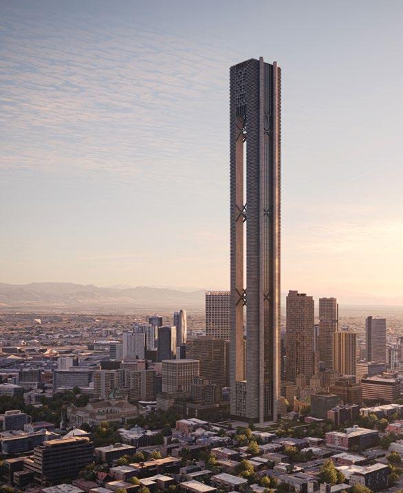
Cover Eden Tower by Oxman.
THE PACE OF CHANGE is such these days, both in geopolitics and in the built environment, that we almost missed acknowledging something important: 2025 is one-quarter of the way into the 21st century. Think about that for a moment: In September 2001, the broad consensus of a world reeling in shock from the World Trade Center and Pentagon attacks was that we would never want to occupy tall buildings again, and that the “skyscraper is dead.”
Flash forward to 2025, and we have constructed more buildings over 200 m than existed in the world at the time of 9/11. Some 88.5% of the world’s buildings 200 m and higher have been constructed since 2001. See our report on 2025 Trends and Forecasts (page 132) for the latest. So, even as we rightfully interrogate tall buildings, on matters of safety— witness the eerily familiar horror of a skyscraper collapse in the recent Myanmar and Thailand earthquakes—as well as for their societal benefit, in the main, it does not seem that vertical urbanism is in retrenchment. We therefore take this opportunity to reflect in several ways on the progress we have made, and will continue to make.
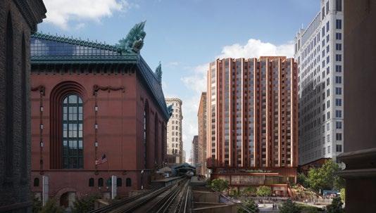
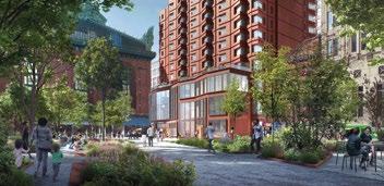
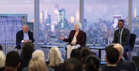
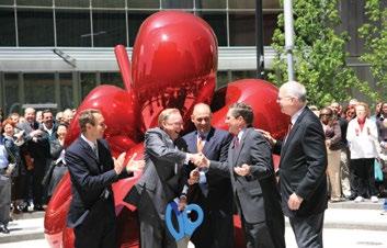
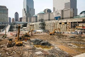
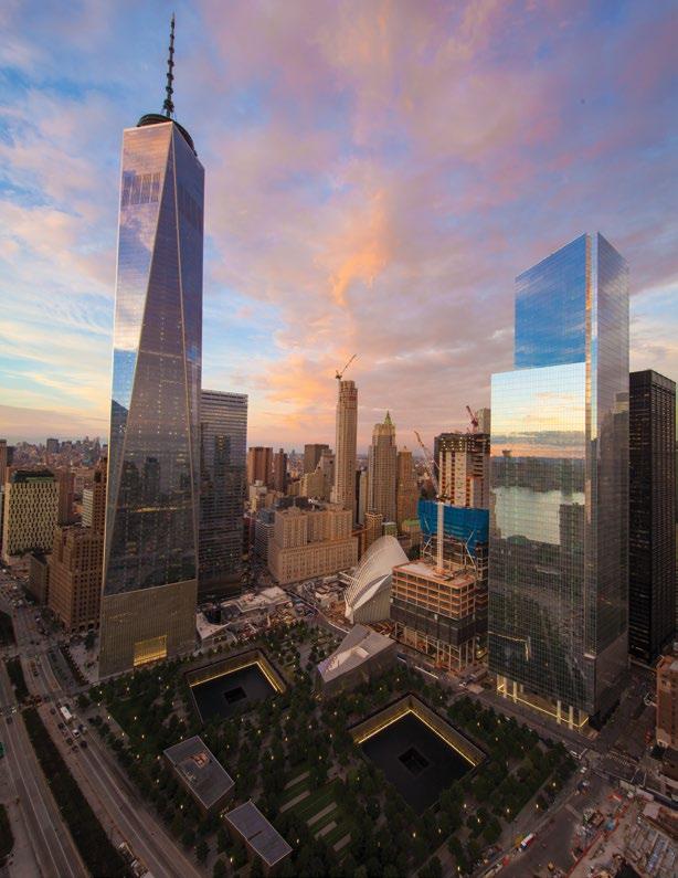
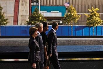
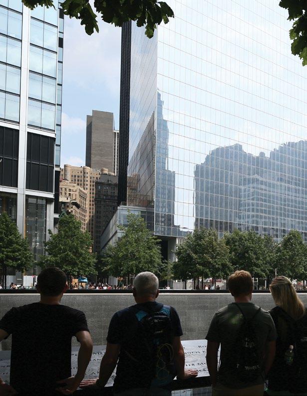
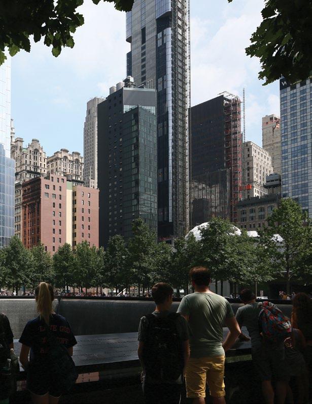
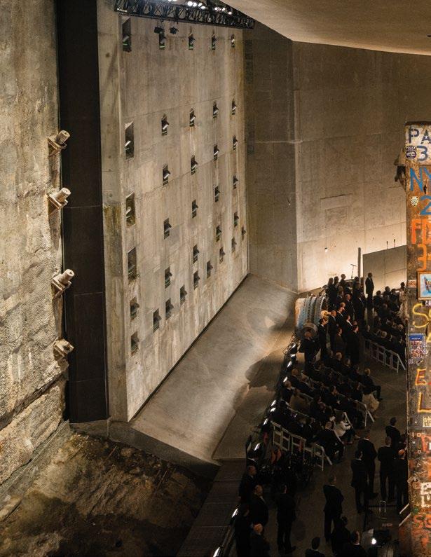
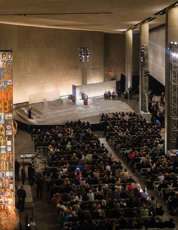
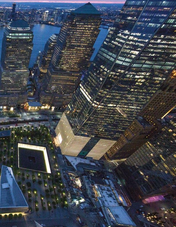
In our Cities section, we hear from two people who lived and breathed the incredible reconstruction of the World Trade Center— developer Larry Silverstein and economist Rosemary Scanlon (see page 76).
To mark the occasion further, we asked 25 top architecture firms for their favorite unbuilt (unrealized, competition, and underconstruction) designs, which we share in the Design section (see page 30). We think you’ll agree that the collective vertical urbanism hive-mind has extraordinary, responsive, and thoughtful projects that rise to meet the challenges of this century.
To reinforce that sustainable vertical urbanism is about more than height, take a moment to examine the research showing how density drives innovation and social progress (page 110); or how computational modeling can contribute to real-world improvements in the public realm, as well as optimize individual building performance (page 120).
Throughout the issue, you’ll see examples of density, not all of which are exemplary, and some of which don’t meet default or intuitive definitions—that’s deliberate. Discussions of density at all scales and contexts is essential to solving planetary issues that are anything but homogeneous.
I hope that these pages will be as inspiring for you as readers as they have been for us as editors. To tackle the rest of the 21st century, we will need all the inspiration we can get.
Daniel Safarik, Editor-in-Chief
Insight Research Focus Agenda
6 BULLETIN
Frances Anderton and Arthur Kay consider Los Angeles after the wildfires, and Ricardo Scofidio is remembered (pictured below).
11 OPINION
Nathalie Palladitcheff argues that mixed-use development should become the new normal—essential for livable, resilient cities.
12 ESSAY
Henry Grabar explores how Tokyo delivers extraordinary density with quality of life intact.
18 ESSAY
Barry Johns outlines strategic frameworks for effective urban densification.
26 ESSAY
Aurgho Jyoti assesses the growth of high-rise living in India, where towers are reshaping metropolitan life.
30 DESIGN
A global snapshot of vertical urbanism today—from adaptive reuse to sustainable high-rise design— spotlighting work by leading architects and emerging voices alike (pictured below).
76 CITIES
Twenty-five years after 9/11, Rosemary Scanlon, Marc Norman, and Larry Silverstein reflect on the rebuilding of Lower Manhattan.
96 CITIES
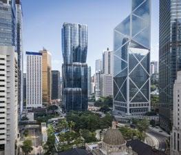
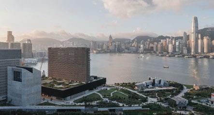
The City Advocacy Forum looks at Hong Kong, Bangkok, Los Angeles, and San Francisco.
110 PAPER
Fatime Barbara Hegyi explores how data analytics can drive more sustainable urban futures.
120 PAPER
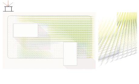
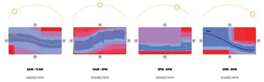
Jeff Kenoff and Luc Wilson present advanced computational modeling as a tool for next-generation tower design.
132 DATA STUDY
Isaac Work delivers a retrospective analysis of 2024 and offers key forecasts for 2025.
134 DIGEST
Tom Benson and Cate Heine summarize critical findings from recent peer-reviewed urban research.
136 INSPIRATION
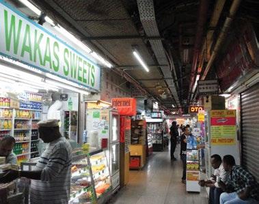
Charles Renfro revisits the chaotic urbanism of Chungking Mansions in Hong Kong—part slum, part vertical village, and wholly original.
138 ARCHIVE
Abraham Thomas sheds new light on Paul Rudolph’s experiments with high-rise typologies and their enduring relevance.
144 REVIEWS
Reviews of: Transform!: Designing the Future of Energy; Creating the Hudson River Park; The Making of Modern Los Angeles; Rome, Las Vegas, Bread and Circuses; Women Architects at Work; the 2025 RETCON conference; the symposium Building a Planetary Solution: Regenerative Architectural Strategies for a Planet in Crisis; and The Brutalist
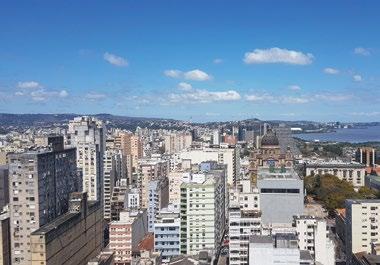
152 LETTER FROM Luis Henrique Villanova writes from Porto Alegre, Brazil.
CONTRIBUTORS
Focus Agenda
FRANCES ANDERTON is a writer, broadcaster, and educator with expertise on housing in Los Angeles, which she writes about in Bulletin (p. 6).
HENRY GRABAR
is a journalist and the author of Paved Paradise: How Parking Explains the World (Penguin Press). The Metropolis columnist for Slate, in this issue he writes on Tokyo’s density (p. 12).
BARRY JOHNS is a Canadian architect and author of Effective Urban Densification: A Guide for Professionals and the Housing Industry (Routledge), which he discusses in an essay (p. 18).
AURGHO JYOTI is founder of AUR, an architecture studio based in New York and New Delhi. He writes an essay about towers in India (p. 26).
ARTHUR KAY
is a board member of Transport for London and co-author of Roadkill: Unveiling the True Cost of Our Toxic Relationship with Cars (Wiley). He proposes a blue belt for LA (p. 8).
JAFFER KOLB
is co-founder of New Affiliates and teaches at MIT. A former designer at Diller Scofidio + Renfro, he reflects on Ricardo Scofidio’s legacy (p. 9).
NATHALIE
PALLADITCHEFF is former CEO of Ivanhoé Cambridge. A leader in sustainable real estate, she writes this issue’s column on mixed-use cities (p. 11).
WILL HUNTER, who curated the 25 projects in the Design feature (p. 30), is executive in residence at NYU’s Schack Institute of Real Estate and Harvard’s Innovation Lab.
PETER MURRAY, who chairs the City Advocacy Forum (p. 96), is the cofounder of New London Architecture and a Mayor of London’s design advisor.
MARC NORMAN, who chairs the discussion on rebuilding the World Trade Center (p. 76), is the Associate Dean at the NYU Schack Institute of Real Estate.
ROSEMARY SCANLON is former Chief Economist for the Port Authority and co-author of 20+ Years of Urban Rebuilding (Routledge) with Patrice Derrington. She took part in the World Trade Center event (p. 76).
NIRAMON SERISAKUL is director of the Urban Design and Development Center (UddC) in Bangkok. She is an urban design expert, and teaches at Chulalongkorn University. She participated in the City Advocacy Forum (p. 96)
Insight Research
LARRY SILVERSTEIN, who took part in the World Trade Center event (p. 76), is chairman of the developer Silverstein Properties. He authored The Rising: The Twenty-Year Battle to Rebuild the World Trade Center (Knopf).
MICAH WEINBERG, who took part in the City Advocacy Forum (p. 96), is a nonresident scholar at the Carnegie Endowment for International Peace.
CLARICE YU is director of buildings for the HKSAR Government in Hong Kong. She participated in the City Advocacy Forum (p. 96)
TOM BENSON, who co-edits the Research Digest (p. 134), is the lead project manager for LabX in Dar, where he is developing a data-driven urban lab.
CATE HEINE, who co-edits the Research Digest (p. 134), is a post-doctoral researcher at the Centre for Advanced Spatial Analysis within University College London, where she studies equity and segregation in transportation systems.
FATIME BARBARA HEGYI is author of The Future of Cities: A DataDriven Approach to Tackling Grand Challenges and Building Sustainable, Resilient Communities (Policy Intelligence Platform), about which she contributes a research paper (p. 110).
JEFFREY A. KENOFF is a design principal at KPF, whose projects include West Lake 66, One Vanderbilt, T. Rowe Price Headquarters, and Huamu Lot 10. He co-authors a research paper on advanced computational modeling and datadriven design (p. 120).
ISAAC WORK, who contributes the data study (p. 132), is building data coordinator at CTBUH, where he focuses on tall building trends and metrics.
LUC WILSON is a director at KPF and leads KPF Urban Interface, the firm’s research group advancing urban design through data and analytics. He teaches at Columbia GSAPP. He coauthors a research paper (p. 120).
PETER BOSSELMANN, who writes in reviews (p. 151) is a professor of design and planning at the University of California at Berkeley.
MARTINA DOLEJSOVA is CTBUH’s communications manager. Her master’s thesis from Columbia GSAPP focused on gender and women in architecture, on which topic she writes in Reviews (p. 146).
CHARLES RENFRO is a partner at Diller Scofidio + Renfro and leads major cultural and academic projects worldwide. He writes this month’s Inspiration (p. 136).
ABRAHAM THOMAS, who contributes the Archive (p. 138) is the Daniel Brodsky Curator of Modern Architecture, Design and Decorative Arts at The Metropolitan Museum of Art, and the author of Materialized Space: The Architecture of Paul Rudolph (The Met and Yale University Press).
SEYFIHAN USARER, who reviews RETCON (p. 149), is co-founder and COO of Algoma, a proptech startup that automates real estate development.
LUIS HENRIQUE
BUENO VILLANOVA is a Brazilian architect, urban planner, and researcher focused on tall buildings. He sends this issue’s Letter From (p. 152).
ANDREW WAUGH, who covers a symposium at Yale (p. 150), is founding director of Waugh Thistleton Architects, a pioneer in lowcarbon design.
MICHAEL WEBB, who reviews a book on Los Angeles (p. 145), is an LA-based writer and author of over 20 books on architecture, including Architects’ Houses and Building Community A Chevalier of Arts and Letters, he contributes to leading design journals internationally.
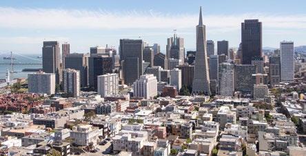
LOS ANGELES, USA
Angelenos Still Resist Building Multifamily Housing
Frances Anderton
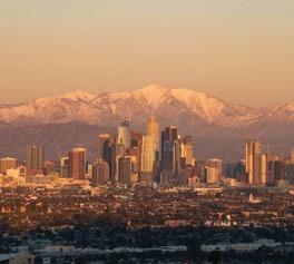
On the face of it, there’s a world of difference between tony Pacific Palisades, where actors, lawyers and hedge fund managers live in multimillion-dollar houses with views of the ocean, and Altadena, nestled inland at the base of the San Gabriel Mountains, and home over many decades to Black homeowners that forged a community there when they were redlined out of buying houses in many parts of Los Angeles County. But there is one thing that unites them: following the devastating Palisades and Eaton fires of January 2025, many homeowners in these two largely singlefamily neighborhoods have no wish for the rebuilt communities to include condos and apartments.
“I don’t want to rebuild next to multifamily housing,” Victoria Knapp, a homeowner and chair of the town council in Altadena, told the Wall Street Journal (8 March 2025). I’ve heard the same point made at many meetings of homeowners from both neighborhoods since the fires. Residents want to hold onto the low-rise, tree-lined neighborhoods of houses on large, leafy lots that they loved, and they are being vocal about it, fearing that state laws aimed at increasing housing stock may be applied now these areas have been reduced to tabula rasa.
Many legitimately fear gentrification and overbuilding by corporate investors, but also reject the chance to rebuild in a way that might help their communities and the region function better. As Knapp also noted in the same WSJ article: “There’s not one person who works at our sheriff’s station that lives within 20 miles from here. Same with the post office.” In the Palisades, some residents object to adding more apartments so the cleaners, gardeners and housekeepers who keep domestic life there ticking along comfortably might live close to their work.
January 2025.
These sentiments reflect the widely held opposition in Los Angeles to “density,” a.k.a. multifamily buildings in Los Angeles. It is a hostility that has been forged over a century of zoning that has segregated people through housing policy—by congregating single family homeowners in R1 zones (which take up some two-thirds of LA’s residential land) and renters in apartment buildings in “commercial” zones, or in public housing. In the past, this land-use separated people
by race; today the opposition to density increasingly unites people by class.
R1 zoning has proven problematic in so many ways, but at least in the early days it could work spatially, when the population was lower, land was available and cheap, freeways flowed, and you could “drive until you qualified” (for a mortgage) from work to your own house.
Today that mode of land-use has reached the end of the road, because the distance between the economic centers
AP PHOTO/JOHN LOCHER
LA’s Pacific Palisades neighborhood, 10
and affordable housing has become a gulf. The City of Los Angeles faces a deficit of 450,000 dwellings, and thousands live on the streets. During a 2023 strike by hotel workers, largely centered on housing costs, a woman named Brenda Mendoza told NPR that the only affordable rental (not a home she could own) was so far from work that she had to rise at 3:30 a.m. to drive 100 miles to her job.
In the last decade or so, there have been a surge of local and statewide efforts
to boost the housing stock through policy tools that increase density close to the growing mass-transit system, resulting in the spread of four-to-seven-story “podium” buildings on commercial strips. In downtown LA, without a homeowner base to oppose added height, towers reach Manhattan heights of 30 to 50 stories.
Any efforts to upzone R1 neighborhoods, however, meet intense pushback, save for one tool: the Additional Dwelling Unit, or ADU, a backyard home also known as a “granny flat,” made legal in 2017 and touted by its authors as a means to achieve “gentle” or “distributed” density that would be more palatable to the homeowners of Los Angeles. The ADU is favored not only because of the ADU’s minimal height, but also because the homeowner owns the structure, adding substantial value to their property.
Back in Altadena and the Palisades, the fires have offered an opportunity, in the view of many urban experts, for a regional reset—either to upzone the torched areas to allow for greater density, or henceforth to try and disincentivize urban sprawl in the high-risk fire zones, while emphasizing denser residential development close to mass transit, in the safer flatlands. This could reverse the trend to build in the wildlands; between 1990 and 2020, the number of homes in fire-prone parts of California grew by 40%, while the number of homes in less-flammable areas only grew by 23%, according to USDA research led by Volker Radeloff, published in 2023.
Such a shift may make sense environmentally and urbanistically, but it is politically fantastical. For now, adding one or two backyard structures is about as much growth one is likely to see in the rebuilt fire-torn areas. Single-family neighborhoods, especially seductive in the lush landscape of Southern California, are the embodiment of the American Dream and simply too alluring to give up, even if holding on to them keeps the state from moving forward.
Frances Anderton is author of the book Common Ground: Multifamily Housing in Los Angeles (Angel City Press).
Isaac Work
LOS ANGELES,
USA
To Save LA From Wildfires, Build a Modern Moat
Arthur Kay
As wildfires increasingly threaten Los Angeles, Mayor Karen Bass’ push to expedite rebuilding risks perpetuating a costly cycle—allowing homes in fire-prone areas to be reconstructed in the same dangerous locations. Instead of repeating past mistakes, LA needs a radical rethink: establishing a “Blue Belt”—a protective moat of resilient blue-green infrastructure designed to shield the city from wildfires while solving its persistent water challenges.
This Blue Belt would transform LA’s vulnerable edges into a network of wetlands, forests, and floodplains that act as natural firebreaks. Drawing inspiration from the city’s history, when marshes and lagoons once regulated water flow and contained wildfires, this approach would restore nature’s protective functions through strategic design. Rather than relying on expensive fire suppression and rebuilding efforts, this approach would work with nature to create a permanent, self-sustaining defense.
What would this look like? Along Ballona Creek and the Los Angeles River, restored wetlands would serve as giant sponges, absorbing rainfall and preventing floods. Strategic placement of fire-resistant vegetation and forested buffer zones would create barriers against advancing wildfires. The network would include overflow zones that disperse stormwater, while bioswales along pathways would filter runoff and replenish groundwater before it reaches the Pacific.
Instead of LA’s current approach— where highways and channels rapidly evacuate rainwater, leaving the city parched between storms—a sponge city retains and utilizes this resource. Picture stepped ponds collecting rainfall, permeable pavements allowing water to seep into aquifers, and rooftop gardens that absorb water while cooling buildings. These water-rich landscapes naturally resist ignition and provide readily accessible water for firefighting.
This vision builds on the “Sponge City” model pioneered by Professor Kongjian Yu, which treats urban landscapes as natural water management systems. Many cities have already demonstrated that urban resilience can be built through blue-green infrastructure rather than endless cycles of destruction and reconstruction.
Rotterdam and Shanghai have transformed flood-prone streets into spongelike landscapes that absorb water, preventing both drought and disaster. New Orleans has restored marshes to protect against hurricanes. And in the San Francisco Bay Area, large-scale projects are converting former industrial lands into tidal marshes that act as natural flood defenses. These cities aren’t just mitigating climate risks—they’re creating healthier, more livable environments in the process.
Implementation would require strategic retrofitting: converting conventional roads and sidewalks to permeable surfaces, installing networks of bioswales and retention ponds, and incentivizing property owners to create water-capturing landscapes. Key corridors would be transformed into expanded wetland parks, serving both as recreational spaces and natural flood control systems.
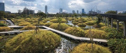
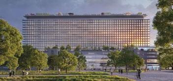
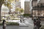
Benjakitti Forest Park, designed by Arsomsilp Community and Environment Architect, is a public park located at Khlong Toei district, Bangkok.
What happens to the communities currently in harm’s way? The reality is that some of the most fire-prone areas—particularly those built deep into canyons and hillsides—may need to be reconsidered. Rebuilding homes in areas that have already burned multiple times is not only dangerous but economically reckless. Instead of forcing residents into an endless rebuild-destroy-rebuild cycle, Los Angeles could follow successful buyout programs from other disasterprone areas. Similar programs to postHurricane Katrina Louisiana could provide residents in LA with a financial choice, rather than waiting for the next disaster to take everything from them.
For those who remain, retrofitting existing communities with fire-resistant design, defensible green belts, and bioswales could mitigate risk. Many global cities have densified while increasing climate resilience—Singapore and Rotterdam have integrated green roofs, permeable streets, and vertical gardens, proving that denser, more walkable neighborhoods can be safer and more livable. Instead of expanding sprawl into the most at-risk wildfire zones, LA should be encouraging compact, fireadapted development where water retention is built into the urban fabric. While creating this Blue Belt requires significant investment, it is far more cost-effective than the status quo. Recent wildfires alone have caused hundreds of billions in damage. Rather than perpetually rebuilding, Los Angeles could redirect disaster relief funds toward prevention. The federal government already allocates billions for climate resilience—LA should stake its claim. Additionally, targeted incentives—tax breaks for green roofs, grants for rainwater systems, and development credits for water-sensitive design—could accelerate private sector participation.
Los Angeles stands at a crossroads. Rather than rushing to rebuild in vulnerable areas, the city can pioneer a new approach that works with nature instead of against it. By establishing a Blue Belt, LA can break free from its cycle of disaster. The time to act is now.
IN MEMORIAM
Ricardo Scofidio 1935–2025
Jaffer Kolb
When I worked at Diller Scofidio + Renfro, we’d often leave design meetings with a list of details and assemblies to test, accompanied by the same refrain: “If, after all that, you still can’t figure it out, talk to Ric.” By the time I joined the studio in 2013, Ric Scofidio no longer joined every meeting. He was often at his desk, with the city beyond as his perpetual backdrop.
He was usually drawing or at his computer, browsing a world of references he would email in response to a question or errant thought. These were often funny, strange, and idiosyncratic. If you were stuck on a project, you’d bring it to him, pull up a chair, and draw through it—sometimes for long stretches—until he’d send you away to test it in measured space (the computer).
His curiosity and humor convened in his love of working through the mechanics of assembly—a hallmark of DS+R’s portfolio. Watching him draw gave me a new appreciation for DS+R’s early installations—the axes of rotation, levers, and machinic qualities of their apparatuses in Bodybuildings at Storefront for Art and Architecture (1987) or the character-like displays in Parasite at MoMA (1989). While projects like these—and many others from that era—may appear as hacked machines of assembled parts, they are grounded in a rigorous drawing practice that situates them within industrial design.
Those drawings and installations established a lineage that led to some of the studio’s best architectural moves: the drop-down mediatheque at the ICA; the surgical interventions along the High Line
that transformed an obstinate form into a generous urban gesture; the mechanical skeleton of the Blur Building. You could describe these projects through disciplinary history, conceptual art practice, or their politics. But they also reflect the time and attention DS+R invests in generating architecture from mechanical relationships—in inventing and refining novel details, even when a readymade or standard option might suffice. Their approach to reinvention can feel exhausting, but it is deeply authentic. On one project, we needed to find an adhesive to bind vinyl to plastic. Ric sent an email on the history of superglue in military field medicine. His interests weren’t superficial; they were expansive. We were to consider the qualities of a glue (for a museum) in the context of the vibrations of a helicopter in World War II bringing a soldier to a hospital. The constellation of associations was rooted in physical mechanics, but produced imaginative layers of material history.
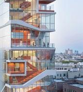
I like to imagine Ric’s hand (and his wit) in some of the studio’s larger projects—the delirious, interdependent surfaces of the Vagelos Education Center; the miraculous detailing of the grand stair in the MoMA expansion; the improbability of the backlit wood veneer paneling at Alice Tully Hall. His influence can be felt across scales—from a bolted connection to a skyscraper—intermingling assemblies of material and form.
Vagelos Education Center, New York (2016).
DS+R / IWAN BAAN
OPINION
MIXED-USE SHOULD BE THE NEW NORMAL
NATHALIE PALLADITCHEFF
For decades, cities have separated functions: offices in business districts, residential on the outskirts, and retail concentrated in shopping centers. Today, mixed-use development is the key to improving urban life while enhancing prosperity and sustainability.
Traditional buildings are designed with a single function in mind. However, as work and lifestyle needs evolve, this approach is becoming obsolete. A mixeduse building is not just a space, but a service that adapts to its occupants’ changing needs. Tenants expect smart technology, shared services, and adaptable layouts. Spaces should shift from offices to apartments or retail to co-working hubs, ensuring longevity and sustainability.
Mixed-use development also brings environmental benefits. Repurposing buildings reduces urban sprawl and carbon footprints by maximizing existing space. In Japan, logistics platforms now include offices, childcare facilities, and dining spaces. Several Asian cities integrate mixed-use designs in vertical buildings, while in Paris, traditional buildings combine offices, homes, and retail, creating dynamic urban ecosystems.
This model promotes neighborhoods where all essential services—work, schools, healthcare, leisure—are within a short walk or bike ride. Cities looking to reduce congestion, pollution, and reliance on cars are adopting this approach. Shorter commutes lead to less traffic, lower emissions, and time and cost savings.
Mixed-use areas foster local interactions and stronger social ties, essential for vibrant communities. They are also economically more resilient. Diverse neighborhoods adapt better to
economic changes than single-use districts. What was once thought to be a crisis of central business districts is, in fact, a crisis of single-use areas. Cities like Copenhagen, Barcelona, and Melbourne have implemented this model, improving urban quality of life and sustainability. The built environment significantly impacts health and productivity. Thoughtfully designed mixed-use spaces reduce stress, boost efficiency, and enhance mental health. Employees working in mixed-use districts have housing, recreation, and services nearby, reducing commute times and stress. Integrating green spaces, public art, and pedestrian-friendly design fosters community engagement and well-being.
Despite its advantages, mixed-use development faces challenges. Real estate investors typically specialize in one asset class making mixed-use projects harder to underwrite. Appraisers struggle to assess the full value of mixed-use properties, as traditional methods do not capture the synergies between different functions. Zoning laws still favor single-use districts, limiting expansion.
Infrastructure and real estate must work together more effectively. Public transport and utilities are often planned separately from real estate projects. Successful mixed-use developments require well-integrated transport links.
Cities and developers often prioritize immediate returns over long-term sustainability, choosing conventional projects over resilient urban models. A key example is office-to-residential conversions, which high costs and regulatory hurdles make rare.
Cities are long-term investments. A new building or urban area will outlast every person who designed, built, or authorized its permit. Urban planning should integrate transport, housing, and public services rather than treating them separately. A human-centered design approach is essential, integrating social and psychological expertise alongside engineering and economics. Collaboration among developers, policymakers, and investors is crucial to promoting mixeduse models that benefit both businesses and communities.
The way we build and organize our cities profoundly affects our and future generations’ lives. Mixed-use development offers a sustainable, efficient, and humancentered alternative to outdated urban models. It fosters economic resilience, environmental sustainability, and social well-being, making cities more adaptable to future challenges.
However, it requires a shift in mindset and a move away from siloed approaches. To make mixed-use development the new standard, we must rethink zoning laws, investment structures, and valuation models. Long-term thinking, industry collaboration, and a commitment to designing spaces for both present and future generations will be key. The question is no longer if we should embrace mixed-use development, but how quickly we can make it the new urban norm.
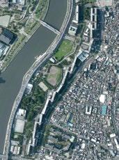
TOKYO’S UNIQUE URBAN GRAIN
A legacy of history and policy, the Japanese capital city’s dense, walkable streets defy modern planning—but for how much longer? asks Henry Grabar
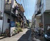
On a recent bike ride through Tokyo, I came face-to-face with the longest building I have ever seen in my life. This was Shirahige Higashi, a 1980s residential complex so gargantuan it registers more as infrastructure than as housing. Indeed, that is its primary function: the line of 13-story towers, stretching almost a mile up the east bank of the Sumida River, north of the Tokyo Sky Tree, is a firebreak.
As such, it distinguishes itself from other modernist tower blocks with its ornament of fire prevention machinery, most conspicuously giant steel gates between the buildings, like stacked canal locks, and red water cannons peering out sentry-like from the third floor. There are 7,000 people who live in Shirahige Higashi’s apartments, but the park carved out between the firebreak and the Sumida River is an evacuation zone designed to hold 80,000.
The enemy at the gates is the next inferno, and in that sense, Shirahige Higashi is more than the aesthetic antithesis of the tangled neighborhoods that characterize Tokyo and many other Japanese cities. It’s a policy response to Japan’s narrow streets. East of the firebreak is one of those labyrinthine
Tokyo neighborhoods that encapsulate the central paradox of the world’s largest city: that it can simultaneously be so big and so small, so loud and so quiet— multisensory overload on one block and pin-drop tranquility on the next.
I won’t try to explain the megacity, but I can take a stab at the peculiar and wonderful character of Japanese urban neighborhoods. It’s the narrow streets, stupid. They’re low-traffic zones by design, which makes them friendly to cyclists and pedestrians, and especially to seniors and kids. This also makes them really, really quiet.
Street parking is impossible, which discourages car ownership by ending the public subsidy for car storage. That’s also part of these streets’ open aesthetic character, which is enhanced by the care of residents, who often adorn the fronts of their homes with potted plants.
Finally, using less real estate for the street means neighborhoods have both lots of detached, single-family houses and the density to support local amenities, such as schools, shops, and transit. You can have your mochi and eat it too.
Some of these qualities are shared by narrow streets elsewhere in the world, of course—a hutong in Beijing, the casbah in
Algiers, a medieval town center in Europe, Society Hill in Philadelphia. What’s interesting about Japan is that these narrow streets are not the unchanged inheritance of the pre-modern era.
Most of them have taken shape since the Second World War, despite the fact that Japanese authorities view them as a major fire risk, an impediment to traffic flow, and a barrier to high-density real estate development. In fact, the state has required streets to be wider than 12 ft (3.6 m) since the 1930s.
Yet in the 1980s, when Tokyo built the Shirahige Higashi firebreak, 40% of homes in Japan looked onto streets that were 12 ft wide or smaller! So the firebreak is a show of intent, but it’s also an admission of defeat: widening streets in the adjacent neighborhood has proven too hard to systematically accomplish.
So why are the streets so narrow, anyway? The historical-deterministic explanation has to do with the relative absence of horses in Japanese urban areas and Tokugawa-era defense strategy, which was more focused on preventing easy access than enabling travel and commerce. More perplexing is that these narrow streets persisted through the 20th century, in built-up areas and beyond.
It was not for Japanese planners’ lack of trying: after the Great Kanto Earthquake and ensuing fire in 1923, which burned down half the city, Tokyo did build Ginza Brick Town, a Westernstyle showcase with fireproof buildings lined up on wider streets. Planners ploughed through the rubble a grid of arterial roads more than 60 ft (18.2 m) wide, which today form the edges of Tokyo’s superblocks. For the first time, Tokyo streets had sidewalks!
The effort and expense was justified by the need for firebreaks much more than in the United States, where such streets were prioritized to ease the flow of automobile traffic. But traffic movement came into play later as well. You can see this traffic-engineering wisdom reach its fullest expression west of Shinjuku, around the foreboding, world’s-tallest City Hall, designed by Kenzo Tange in 1991. Perpendicular
streets run at different levels to avoid the need for stoplights, and pedestrians moving diagonally must climb and descend staircases at every turn.
I had two books in my Tokyo backpack: The Making of Urban Japan by Andre Sorensen and Emergent Tokyo by Jorgé Almazan, Joe McReynolds, and Naoki Saito. They played the roles of cartoon devil and angel on my shoulder, respectively, with Sorensen constantly upbraiding the city’s governance and decrying its poor quality of life, while Almazan et al. ponder its mysteries with respect and awe.
Sample Almazan: “A city of intimacy, resilience, and dynamism built from the bottom up.” Rebuttal Sorensen: “The Japanese urban resident is thus left with the worst of all worlds.” They were in constant dialogue in my head.
Sorensen argues that Japanese city planning has always been weak compared to its American counterpart. This laissez-faire attitude is often praised in the context of Japan’s lax zoning regulations (small shops and offices are permitted everywhere) or its hypercompetent private train companies. But the narrow streets offer another example.
In the postwar rush to rebuild, Japan made two decisions that laid the foundation for its narrow-street future. First, land reform broke up the country’s big agricultural holdings into many tiny farms. Second, planners exempted developments of less than 1,000 m2 from land-use review. The result was a wave of micro-developments, often in the form of a dozen or so houses clustered around a lane that ran off an existing street. Fragmented land ownership made it hard to build Levittowns in Japan, and developers of the resulting small plots wanted to maximize every square meter they had.
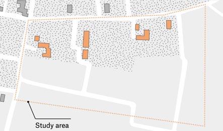
Meanwhile, to the extent that such garden suburbs already existed, they were undergoing a process of densification, an evolution that Emergent Tokyo makes visually clear (see maps, next pages). Some combination of a postwar inheritance tax, tremendous urban growth, and no minimum lot sizes saw
Left and top— An urban firebreak: the Shirahige Higashi Apartments, a line of 13-story towers, stretching almost a mile along the Sumida River.
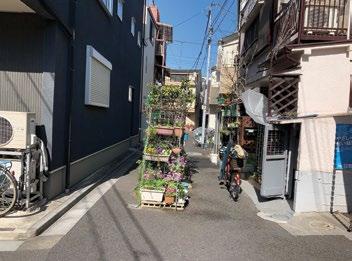
Above— Carless streets are enhanced by residents adorning the fronts of their homes with plants.
HENRY GRABAR
1909—
On Tokyo’s rural outskirts, a few houses stand scattered in a bamboo forest.
With the opening in 1927 of the Nakanobu and Ebara-Nakanobu
Stations the area rapidly urbanizes, although large tracts are still unoccupied.
A grid of new roads is laid out throughout the new Western suburbs in preparation for new construction, mostly by absorbing preexisting paths.
Source: Tokyo Seihokubu (Dai Nippon Teikoku Rikuchi Sokuryōbu, 1929)
1970—
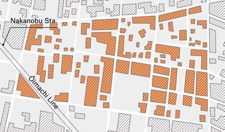
The area has become much more accessible. Nakanobu Station was elevated in 1957 to alleviate traffic on the Daini Keihin Highway. In 1968 the Asakusa Line begins alighting at Nakanobu Station. The area continues densifying, with houses occupying their blocks’ whole depth and new alleyways providing access to them.
Source: Jūtakuchizu (Zenrin, 1970).
2019—
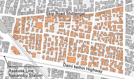
The buildings along the highway have become apartments and office highrises. Skip Road, the local shōtengai, is still thriving, with a mixture of franchises and independent stores. Many of the residences’ front gardens disappeared as the area continued densifying.
Source: Jūtakuchizu (Zenrin, 2019).
Image credits—
Reproduced with permission from “Emergent Tokyo: Designing the Spontaneous City” Jorge Almazán + Studiolab, ORO Editions.
fewer, larger houses on larger lots torn down to make many smaller houses, packed in but not quite touching— like a box of chocolates.
Though the law required rebuilt houses to have a 1.2-m setback from the center of the road, in practice, Almazan writes: “Landowners are generally uninterested in living in a smaller house in the name of the public good, and they frequently use a variety of legal tactics and loopholes to resist the setback obligation and preserve their precious square meters.”
It’s easy to categorize a new building as a renovation if it includes just a few original elements of what came before. It’s a domestic equivalent of the periodically renewed Ise Shrine. The sociologist Toshiya Yoshimi, who guided us through the Ueno Park area in Tokyo, pointed out the similarity between the
Right—
The most famous narrow streets in Japan are the privately owned alleys of Golden Gai, where some 200 bars are crammed into an area the size of a baseball diamond.
Japanese word for building or manufacturing, tsukuru, and that for mending or repairing, tsukuroi I’m hesitant to lean too much on Japanese cultural qualities here: the narrow streets are a creature of policy (or lack thereof), not of some innate Japanese sense of what a street looks like. That said, there’s no doubt these streets— adorned with pockets of vacant space between buildings (one regulation that has succeeded)—create a different urban culture, most obviously the different culture of mobility.
Paradoxically, the absence of sidewalks and street parking, two elements many US planners use to protect pedestrians from cars, makes for super-careful drivers. For cyclists, of which there are many, especially in the flatter, more middle-class areas in eastern Tokyo, these streets are always
two-way. Kids run ahead of their parents or simply walk home alone. There is little through traffic, because the street grid is so complicated. The absence of by-right free street parking keeps car ownership low. And mass transit, shops, and restaurants are always close at hand because—as developers and subdividers reasoned when these places were built—narrow streets allow for greater population density, even when everyone has their own detached house.
Needless to say, this hyper-density is also permitted by narrow streets in commercial areas. The most famous narrow streets in Japan are the privately owned alleys of Golden Gai, where some 200 bars are crammed into an area the size of a baseball diamond. The district is a bit of a tourist trap, but there are similarly vibrant alleys around train stations elsewhere in Tokyo, like Ameyoko.
Then there is the culture of public space. These narrow streets blur traditional boundaries between private and public. Residents and shopkeepers take ownership over the public sphere, whether with potted plants, a morning sweep, or a rack of goods for sale.
Strong neighborhood associations manage bigger issues. Personal objects spill out from the home in a practice of afuredashi (overflow), including children’s toys, tools, and drying laundry. For me, wandering in the lee of the firebreak tower block, the cumulative effect was one of architectural inversion, as if the utilitarian function of the American backyard had been relocated in miniature to this little asphalt strip.
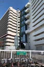
And yet the Tokyo Metropolitan Government is determined to get rid of such places, and it is succeeding. Fireproofing is the chief rationale, but there are additional motivations. Japan has strong sunlight protections, and wider streets permit taller buildings. Politicians like shiny new developments over there, and Tokyo’s stock of six-plusstory apartment buildings has more than doubled in the last two decades.
It’s not really for me to say how the costs and benefits of this approach stack
up. Sorensen is adamant that the existing fabric is a firetrap since the buildings are almost all made of wood, even if they don’t look like it.
Emergent Tokyo argues that high-rise development has problems of its own in disasters (broken elevators, power loss), and these traditional areas have strong mutual aid networks, which is what really counts when things go south. Perhaps these areas could be reformed without being demolished.
One word that stuck with me from Emergent Tokyo was nihonjinron: the idea that the “unique qualities [of Japan] make Japanese society difficult or impossible for outsiders to analyze and understand.”
This belief in an innate Japanese difference is not only an exoticizing tendency of Western observers; it’s also a common thread in Japanese analyses of their own politics and culture, urban or otherwise. One way or another, its function is to discourage border-crossing inspiration and translation—to make the street between our proverbial houses so wide we can barely speak.
We have much the same custom in New York: the feeling that New York is better than everywhere else, so there’s nothing to learn, except when it’s worse,
in which case there is also nothing to learn, because New York is just different. “Newyorkjinron” is alive and well in the city’s attempt to dispose of its garbage, for example.
What I hope this yarn about the dance between policy and street width shows, however, is that there is nothing innately Japanese about Tokyo’s narrow streets. It is mutable. In fact, it is mutating as we speak. Here, Japan could maybe look to the United States, where the twin regulatory prerogatives of fire safety and traffic speed have shaped the environment far more than any homegrown vernacular urbanism.
We have required every apartment above a certain floor be accessible by two interior staircases, dividing our structures with long corridors, constraining our architectural output, and increasing housing costs. We have literally required that people live at greater distances from one another, and yet people wonder why everyone spends so much time alone. Perhaps six feet is a little narrow for a street, but there’s some middle ground. Fire trucks come in different sizes, too.
This article first appeared on the author’s blog onthegroundfloor.substack.com
Right— Tokyo’s narrow streets blur private and public life.
HENRY GRABAR
ESSAY A MODEL FOR GENTLE DENSITY
To solve the housing affordability crisis, we need to leverage backyard spaces to increase supply without erasing existing neighborhoods, argues Barry Johns.
The densification agenda to advance housing attainability and affordability with mixed-use typologies around North America is long overdue. This quest is fundamental to successful urbanism— from the urban core to the low-/mid-rise “missing middle” in neighborhoods. Growing populations, increased infrastructure costs due to sprawl, and ongoing arable land consumption have plagued our cities since the postwar building boom of the 1950s. Now, affordability is in serious crisis.
Described as the “center of gravity” within this problem space, this essay explores densification to improve concepts, policies, and technologies in the pursuit of sustainable, healthy cities. Notable projects examined in this essay target the social component versus height per se. The merits of adaptability versus demolition, mixed-use and a vibrant streetscape also fit deeply into this conversation.
Demolition (in the context of environmental sustainability) is harder to justify today, as usable building stock has already digested its share of the environment. Adaptability and reuse together constitute a much more responsible approach to environmental stewardship—whereas demolition feeds the landfill, and building anew means
starting over again to consume newly purchased resources.
Well-designed streets and public space can also re-invigorate buildings that are given new life. Vertical layers now expand the urban fabric to include public green space in skygardens or roof terraces to improve the built environment. These additions suggest a new beginning of resiliency and sustainability to breathe energy into empty or underutilized high-rise structures, commercial and industrial buildings, as well as optimizing reuse of the land itself.
Developers can more readily absorb the cost of public amenities inside an already paid-for shell. Here, residential occupancies and support commercial services can now be more economically considered as well, since the high initial impact of land cost can be amortized or removed across other more profitable uses. Mixed occupancies thus yield more efficient use of finite urban land while stimulating organic growth and increased density in the urban core.
At the other end of the urban scale is the mature neighborhood, where zoning reform promotes densification to address the housing crisis. However, instead of adapting and reusing serviceable housing stock, neighborhoods are being atomized by demolition to make room for new
product—mostly in the form of infill or apartments. One needs to ask if there are other, more sustainable options.
In this essay, I address a similar nexus—that of finding a more efficient use of suburban land in response to the same ideal of concepts, policies, and technologies that can better manage density, foster sustainability, and make cities.
In Canada, the Central Mortgage and Housing Corporation (CMHC), overseeing the housing question, led a challenge to planners and architects to densify the single-family neighborhood as far back as 1979, but to no avail.1 There has been little traction since. Most cities in North America inexplicably continue to default to increasing the supply of the superseded 1950s dream of house, yard, car, and family as the de-facto baseline solution to the housing crisis.
Government policy to increase the supply of the stick-frame single-family dwelling (where success is measured by reporting increased numbers of “housing starts” year over year) fails to address the dynamics of using up arable land, changing demographics to smaller households, and the complex sociocultural-economic realities of a deeply complex housing crisis. Few regions across the continent embrace policies that
fulsomely examine any of these impacts. This is left to an outdated housebuilding industry to ponder the needs of an aging society, where the average family household in Canada is forecast to be one person in the next 25 years when it is neither equipped nor motivated to do so.2 Add to this the regulatory framework, outdated zoning (despite recent reforms) and the risk-averse constipation of the banks towards innovation, and we are left with a formula that yields no real answer, just increased cost.
While the search for an affordable home in a safe neighborhood was serious enough before the pandemic, recent developments have increasingly denied a larger cohort—regardless of class, race, and inequality—where even higher middle income earning professionals from teachers, nurses, and skilled tradespeople cannot afford to purchase a house. Climate change and extreme weather events, inflation, interest rate increases, immigration, and geo-political strife all taken together, seriously impact housing attainability and cost across the continent. Now more than ever, viable answers to the housing question need to
reside at the very core of making resilient and sustainable cities.
The housing crisis in North America thus confronts two macro-challenges— urban sprawl and affordability. Zoning reform that enables unfettered densification in cities is the current zeitgeist to address this crisis; the principle being that all barriers to development must be removed so the supply chain can bring more product to market as soon as possible. This yields commoditization that is supported by politicians, regulators, and of course the housebuilding industry, all of which claim increasing a predictable supply will bring prices down and thus improve affordability.
The missing middle story, championed by Daniel Parolek, promotes densification by filling existing market housing gaps with varied, dense, walkable urbanism at the neighborhood scale.3 This has had a deep influence on zoning reform from Portland to Minneapolis, Vancouver, and Edmonton, where single-family housing is now either discouraged or no longer, advocating instead between three and eight smaller units on a single titled lot.4 Various forms of infill as a result are the start points for many cities, assuming that affordability will follow.
However, these ignore the negative impacts in communities such as the prairie city of Edmonton, Alberta (pop. 1.6 million). Here, instead of meaningful community consultation to develop and
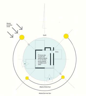
Right—
The author’s BAAKFIL concept seeks to overcome land-cost constraints on densification by enabling construction in backyards of single-family homes.
manage the densification agenda, in 2024 a new blanket one-size-fits-all zoning bylaw responds to its long-term City Plan by presupposing a limitless ongoing redevelopment of entire neighborhoods through demolition and rebuilding.
Other cities like Cambridge, Massachusetts take a middle road approach where density increases are only allowed in return for building the so called “permanently affordable” housing unit. Densification strategies across the continent are certainly varied, but all are largely predicated upon a developer entitlement model—to increase supply at all costs. What is missing is a fulsome prioritization around neighborhood revitalization—retention of viable existing housing stock, preserving streetscapes, tree canopies, parks and open space, addressing land cost and finally, tackling affordability.
The Land Calculus
In Canada, CMHC’s affordability barometer is one’s ability to pay for housing costs up to 30% of gross income. With rising land costs over the past generation and two-income households, this definition holds less meaning, for it is not unusual for this number to escalate well beyond 60% in larger, landlocked cities where the only way to expand is up.
The term “affordable housing” has now attached to it an implicit stigma that changes public perception when ideas around incentivizing it are raised. People become fearful about the idea of affordable housing, and who it might bring into their neighborhood.
This is brought to light in Sick City: Disease, Race, Inequality and Urban Land, where the author cites land prices per acre in America’s super cities of New York, Los Angeles, San Francisco, Washington DC, and Chicago in the low millions of dollars. In New York City alone, private land value in Manhattan increased by 3,000% since 1995.5
These are extreme examples, yet the same is true in Canadian cities such as Toronto and Vancouver, where land cost has so distorted the marketplace that home ownership is almost completely unavailable to those who could afford to be multiple homeowners in other cities. Despite the socio-cultural arguments about the effects of inequality and the continued erosion of consumer buying power, the basic fact of exponential land value increases is key to understanding how far we have fallen into the affordability abyss.
Land value is not real value that accrues to productivity or statistically to a country’s gross domestic product
Left—
In space typically sacrificed for required setbacks, the BAAKFIL concept also allows for development of communal space, away from street traffic, on lots that are not ideal or desired for new construction.
(GDP)—it is rather a manifestation of unabashed fabrication by speculators. It exists in disproportionate contrast to construction costs that have only increased to match the cost of living and inflation in the last generation. This is the wicked problem. There is no way to integrate land value today in any conversation about affordable housing— or, making housing more affordable— unless land costs can be seriously mitigated, or eliminated altogether.
This is the real problem in the mature residential neighborhood. Land value is not real. It is completely fabricated and priced to what the market will bear. When new density is allowed, the land price always goes up—yet the cost of construction stays current with the market. Consider the following example:
The Dovercourt community of Edmonton is a typical Canadian single-family, mature neighborhood; emblematic of the 1950s North American Dream of a titled lot for a growing family in a suburb of the city. Today, it is now better served by rapid transit, is less reliant on the car and has become a verdant, walkable, and permeable community within minutes of downtown, close to all other amenities expected in today’s contemporary urban systems.
With the enactment of new densification bylaws, the community is now rapidly being discovered as fertile ground for infill and larger apartments. If a single-family lot is sold, the house is demolished and the lot subdivided for two infill units, the speculative value of the land is almost automatically doubled. Using round numbers, a 50-ft-(15-m)wide lot with an existing house of about 1,200 sq ft (111 m2) generally sells today for up to CA$425,000 (US$295,120) in this neighborhood, which is slightly less than the average cost of housing in the city.6 A subdivided 25-ft-(7.6-m)-wide empty parcel is now worth close to the same CA$425,000.
This obligates the developer to build to the maximum allowable under the new zoning bylaws to justify the land cost and recoup their investment. Thus, we see oversized infill product on each lot, often three stories and up to 2,500 sq ft (232 m2), with very little residual yard space, including loss of trees and landscaping, that replaces the smaller original house. This two-infill-project example doubles the land density, and the total development will sell for CA$1.6–1.8 million (US$1.11.25 million) in the open market.
While this is considered modest compared to many other cities, infills are commanding (depending on location)
more than CA$1.3 million (US$901,940) per unit in certain areas of Edmonton today on skinny 25-ft (7.6-m) lots. Land at almost 50% has a huge impact on total cost. This is the unintended consequence of speculative infill. It does not advance the affordability agenda as advertised. It does advance a densification agenda, but it unassailably increases housing cost, completely militates against affordability, and when poorly designed, it negates many of the redeeming values of the neighborhood where it is situated. Neighborhood acceptance, as a result, is fleeting. Dovercourt will nevertheless catch up to the saturation of large infill development that we see elsewhere in the city regardless, since given the land calculus, there are few alternatives.
In the end, it is all about land cost. One solution is to eliminate it.
BAAKFIL
Effective Urban Densification addresses these issues.7 This publication introduces a different way of thinking about affordability and gentle densification of mature urban neighborhoods called BAAKFIL—an acronym for Back Alley Advantage, Kinship, Family and Integrated Living.
This in context with today’s imperative of respect for socio-cultural-
Left—
Backyard infill projects should be bike-friendly and introduce potential for shade-producing greenery.
economic realities and changing demographics to smaller households, neighborhood character and sustainable community revitalization. The cost of land is posited as the biggest barrier to housing affordability, while the underpinnings of BAAKFIL are based on retention of existing serviceable housing stock, rather than demolition.
These issues are explored in a new business model about equity leveraging, where an owner partners with a developer by putting up its backyard space for development while retaining tenure in the original house and property. By sharing the profits of sales (or rent) with the developer, the landowner monetizes its asset without putting up any cash, continues to live in the original house and is not displaced from it. The landowner in effect re-invests in his or her own neighborhood. The developer builds new housing on a titled lot without purchasing or financing land.
Land cost is removed from the project pro forma. In Edmonton (an affordable city compared to many in North America), where land cost approaches 50% of the total cost of infill, the development cost is reduced substantially, and that instantly increases affordability to the consumer. In the example provided, with land cost removed,
a single BAAKFIL unit of 1,000–1,200 sq ft (93–111 m2) would sell at minimum CA$150,000 (US$104,145) below the average cost of housing in the city today. These savings would of course be greater in cities where costs are higher.
Developers are incentivized by the model, despite having to share a smaller profit with the landowner. Considerable overhead costs are eliminated by not assembling land or financing its purchase, there is significantly less risk as the land is used as collateral against construction financing, and finally, more projects can be completed at the same time.
BAAKFIL importantly gives agency to the landowner to promote sustainable and respectful architecture on its property, responsive to the neighborhood context. This is obviously meant to maintain social networks as they age in community, but to also protect his or her investment. Depending on lot size and the number of units, BAAKFIL becomes
a viable option for a landowner’s adult children, who otherwise cannot afford to buy back into the neighborhood where they were raised. Units can also be available to a wider demographic of kin, colleagues and newcomers—enabling intergenerational, or multicultural-enclave, or cottage-court missing-middle typologies.
BAAKFIL draws broader conclusions about density, micro-communities, smaller household demographics and sustainable, resilient cities. It promotes the ecology of urban neighborhoods by advocating the revitalization of city alleys with mixed-use, sidewalks and separate addressing. Neighborhoods with small businesses, such as a hair salon or coffee/sandwich shop on a corner lot or in a back alley, are immensely popular where permitted in many cities and add character to the neighborhood. Moreover, with the retention of existing houses and respectful scale, these developments may not even be visible from the residential street.
This is a scalable solution across the continent that supports preservation of existing housing and population growth at the same time. While not for everyone; if only a minority of 25% of single-family properties in the 84 mature neighborhoods of the City of Edmonton were to commit BAAKFIL over a period of 25 years, for example, this would quietly amount to an
Left— Infill development can also allow for communal pathways, sheltered from foul weather.
increase in housing stock for more than 250,000 people. This is a non-disruptive, gentle densification agenda that could translate to millions in population growth over the same period of time across Canadian cities.
The underlying urban message of a BAAKFIL development is to retain existing streetscapes and to enhance the defining characteristics of neighborhoods while filling in underutilized titled lots with a more efficient use of land. In the City of Edmonton, where standard lot sizes range from 33 x 120 ft to 50 x 150 ft (10 x 36.5 m to 15 x 45.7 m) and larger “pie”-shaped lots—fully 40% of a titled lot is absorbed by unused setbacks. That number rises to a staggering 70% when undeveloped yard space is included. There is plenty of newfound land available for development in a mature neighborhood without demolition; just as we find in the open parking lots, undeveloped sites and vacant, re-usable buildings in our city core.
Unlike other densification initiatives, the business model does not rely upon government regulations such as rent controls or incentive subsidies to make housing seem more affordable. It does not promote an increase in development levies and no density bonus provisions are needed.
The purpose is to advance densification by stimulating the landowner to monetize what is often its largest investment (i.e., purchasing a property). It is a free-market strategy that promotes the simplicity of a bareland condominium model and modifies it to enable landowner equity participation.
BAAKFIL is finally predicated on home ownership as a lifestyle choice, not an investment instrument. The housing market has become a singular vehicle for wealth storage (with absentee owners) that, when considering its impact on average housing prices, yields increasingly uneven development, heightened social inequity and higher cost. The model alternatively integrates socio-cultural-economic innovation within the housing industry at societal scale. Any house builder can commit
BAAKFIL with a landowner. With gentle densification of mature neighborhoods over time, BAAKFIL increases affordability with redeeming sociocultural value.
Lessons about Densification
Most citizens understand the need for, and are supportive of densification. Neighborhoods are also not averse to change; homes are renovated and yards are altered all the time. Just as families grow and shrink, the act of change is the act of living. But it is also a matter of scale and degree. NIMBY (“Not in my Backyard”) is manifest with citizen action groups when dramatic change is superimposed upon them without respect or sincere consultation—such as bylaw reform that deconstructs the fundamental assets of their street, block and neighborhood. It is little wonder that communities are fearful about zoning reform. When prices go up dramatically, social makeup and street character are compromised and new product is oversized, disrespectful, and out of reach of the average incomes of the neighborhood. This naturally yields antipathy from those who have spent decades paying off their debt and who have grown to simply love their neighborhood. Cities have yet to figure this out. This is not NIMBYism. That has become a trope with municipalities. It is also not elitist. Citizens simply want to be included in the development conversation and naturally expect that the outcomes will not negatively alter their lives.
Jane Jacobs famously states in The Death and Life of Great American Cities that “cities have the capability of providing something for everybody, only because and only when, they are created by everybody.”8 It is possible for densification to fit into a neighborhood without exacting any concessions from it—if it is executed by the neighborhood. People naturally do not welcome buildings that are poorly designed or poorly integrated into their surroundings if they detract from other accepted amenities and landmarks already well-
established, such as mature trees, parks, gardens, porches, and verandahs— many of which are either removed or not part of infill development. (It is ironic that new density in the urban core is discovering the merits of natural skygardens and green space aloft, while densification of mature neighborhoods is prone to destroying it at the street.)
I cite the verandah metaphorically— the loss of which, in an established neighborhood where people walk their dogs or casually interact with their neighbors, means the erasure of a piece of unregulated life, and with it eventually, its history and memory. Continued loss only increases this erosion. These are the values espoused by Jane Jacobs, who understood that the messy, eclectic patterns of living
Below—
A 3-D model of an infill development following BAAKFIL principles.
Solar and wind orientation study for infill plan.
make mature neighborhoods inherently unique, rich, and lovable. Actions of erasure when the priority is a one-sizefits-all approach to densification ignore these important social constructs. With this approach, the specter of homogeneity is raised, as in suburbia. Separating widespread demolition from the densification objective is critical to the maintenance of a treasured social connection, whether by relationship or by chance. Just as the urban core needs a safe and vibrant public realm, so too does the mature neighborhood.
The verandah is analogous to the attributes of a stable community that in effect is self-governed at the granular level, providing personal comfort, safety through eyes on the street, and neighborliness through
informal interaction. The idea of designating the “heritage street,” or in other words, municipal management to protect mature streetscapes, is equally compelling. The integrity of a neighborhood street is as vital to a community as are its public open space, and park amenities. Such a designation would be a welcome antidote to bylaw reform where street character is impacted by erasure. Municipalities need to understand their own accountability to citizens in this regard.
Neighborhood character varies in the cross-section of the city. It necessarily develops its own DNA differently from others, impacted by people’s uniqueness, experience, and identity. The quality of its street life impacts the city, its
Right—
“If just 25% of singlefamily homeowners in Edmonton participated in this model over 25 years, the city could add enough housing for 250,000 people.”
inhabitants and its reputation. Residential densification needs to recognize and celebrate this uniqueness, instead of repeating the mono-cultural banality of the suburban ideal.
This points to the need for municipalities to proactively manage the public realm and communityfocused design, instead of only enacting bylaw reform that is developer-centric about supply only. By promoting organic growth and appropriate housing architecture with a deep respect for neighborhoods, we can enrich the daily act of living. Essential to the survival of our cities, we achieve this by reimagining simple residential typologies to mitigate or remove land cost and return new, relevant housing stock to more affordable levels.
NOTES
1 Central Mortgage and Housing Corporation (CMHC). (1979). National Housing Design Competition.
7 Johns, B. (2024). Effective Urban Densification. New York: Routledge.
8 Jacobs, J. (1961). The Death and Life of Great American Cities. New York: Random House.
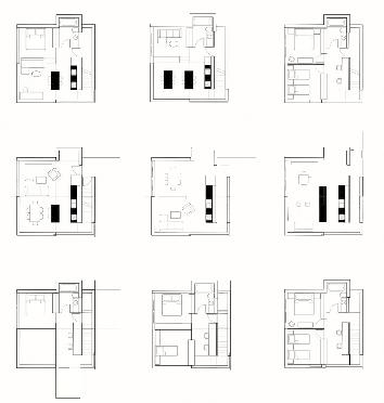
Right— Plan options for infill design following BAAKFIL principles.
Image credits— All images are courtesy of Barry Johns Architect.
ESSAY THE INDIAN HIGH-RISE REIMAGINED
Instead of importing the West’s glassand-steel towers, Aurgho Jyoti advocates for India to generate its own culturally specific high-rise typology.
The high-rise is more than just a building—it is an economic multiplier, an emblem of urban ambition, and an assertion of material and technological prowess. It embodies Western capital and modernist ideals but also symbolizes vulnerability, as seen in the destruction of the World Trade Center. That event not only called into question the typology’s significance, but also ignited a broader conversation about the role of high-rises in contemporary cities. Can this architectural form be adapted to India’s urban conditions with its diverse climates, cultures, and contexts?
Rooted in the landscapes of Chicago and New York, the high-rise emerged as an urban solution made possible by cheap energy, steel, concrete, and glass. Before the 19th century, most buildings rarely exceeded six stories, constrained by technological limitations, including the absence of adequate water pressure and mechanical vertical transportation.
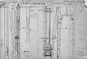
The invention of Elisha Otis’ safety elevator in 1852, along with advancements in steel and reinforced concrete construction, changed everything. As
Elisha Otis’s Elevator Patent Drawing, 01/15/1861.
architect Rem Koolhaas observed, “Otis’s apparatus recovers the uncounted planes that have been floating in the thin air of speculation and reveals their superiority in a metropolitan paradox: the greater the distance from the earth, the closer the communication with what remains of nature (i.e., light and air).” These advancements later shaped India’s urban landscape, as its major cities adopted the high-rise as a response to growing populations and economic liberalization. For centuries, human settlements were anchored to the ground, with verticality reserved for sacred structures rather than residential or commercial space. The ground was tangible, familiar, and communal; the sky represented the unknown and the sacred. In Indian tradition, spirituality
Above—
often informed urban form—temple towns and stepwells are examples of verticality with communal and cultural significance. While temples represented verticality above ground, step wells signified a verticality below ground. As density increased and the rationality of capital took precedence, the ground became a finite resource that had to be replicated in stacked planes reaching skyward.
But is the high-rise the only viable model for dense urban living? Can it be reconciled with India’s cultural specificity, human scale, and vernacular materiality? And how does it coexist in India with the deeply ingrained fabric of urban villages and informal settlements?
Traditional cities evolved over time, shaped by climate, geography, and social organization. However, the rapid urbanization of the post-industrial world led to the proliferation of generic, placeless cities. The rise of the market economy and its parallel real estate transformation, particularly in the post-oil Middle East and reform-era China, accelerated this shift, producing
KEN WEILAND (CC BY-SA)
Above—
The Mahabodhi Temple, an ancient, Buddhist temple in Bodh Gaya, Bihar, India.
Left—
Qutab Minar, a minaret and victory tower sited at Delhi’s oldest fortified city, Lal Kot.
high-rise-dominated skylines at an unprecedented pace, devoid of historical continuity. The high-rise, an American urban typology, found new homes of proliferation.
India followed suit after its economic liberalization in the 1990s, with highrises proliferating as housing became a commodity. Harvard University academic Rahul Mehrotra’s concept of the “Impatient Capitalist” aptly describes this unchecked development in India. Yet, India’s medieval architectural history offers an alternative vision. Historically, Indian verticality in architecture was not about real estate but about spirituality and urban markers of events. Structures like the Mahabodhi Temple and Qutub Minar were built as indicators of sacred significance, deeply integrated with their cultural context. Similarly, temple towns such as Madurai or Thanjavur illustrate how Indian architecture has long explored verticality for functional and spiritual purposes. In contrast, many of today’s high-rises disregard their urban surroundings entirely,
repeating identical unit plans with no relation to the city’s layered history.
In India’s modern history, the first four decades after independence were marked by institutional modernism, as an attempt to forge a national identity through architecture. The modernist vision of India’s first Prime Minister, Jawaharlal Nehru, embraced industrialization and architectural modernism as symbols of national progress, exemplified by Le Corbusier’s Chandigarh. Significant institutions were built during this era in the nation-building process. The cultural specificity of the modernistic project in India, often without historical continuity, can be argued. However, the postliberalization high-rise abandoned specificity completely, reducing housing to formulaic, repetitive towers that ignored climate, culture, and community.
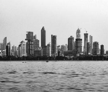
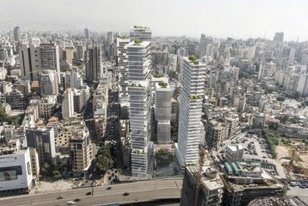
Mumbai alone accounts for 77% of India’s high-rises, while Kolkata has only 7%. The disparity arises from various factors—Mumbai’s severe land constraints and real estate demand have driven vertical expansion, whereas Kolkata’s planning regulations and historical urban
Left— Mumbai’s skyline in 2022. The city accounts for 77% of India’s high-rises.
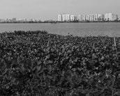
Below— Skylines of Newtown and Salt Lake, Kolkata, from the wetlands.
fabric have resisted rapid high-rise proliferation in the city’s core. Yet, few of these tall structures in Indian cities engage meaningfully with their environments. If one were to transplant many of Mumbai’s new towers to Dubai, they’d hardly feel out of place. In an era of placeless urbanism, a placeless high-rise fits right in.
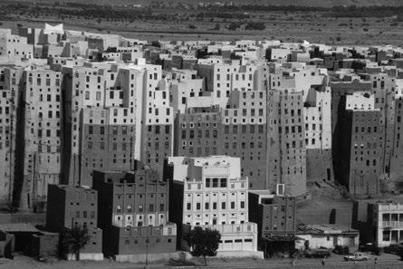
Scale is another critical factor. Architecture has always been shaped by human proportions—stair risers, corridor widths, and doorways all reflect the proportions of the human body. Most historic settlements prioritized horizontal growth, fostering social connectivity. A rare exception is Shibam, Yemen, the world’s oldest skyscraper city, where five-to-eleven-story mud-brick buildings evolved in response to local conditions. Could contemporary high-rises adopt similar principles? Charles Correa once argued that four stories was the optimal height for maintaining human connection. Perhaps instead of monolithic towers, high-rises could be envisioned as vertical clusters of four-story neighborhoods, where circulation spaces function as public streets rather than sterile corridors.
Materiality is equally pressing. Structural limitations and ease of construction have established concrete and steel as default material choices for high-rise structures. For over a century, steel and concrete have dominated high-rise construction, but at an enormous environmental cost. Concrete alone accounts for 8% of global carbon emissions, while the energy demands of cooling and lighting exacerbate the issue.
Timber-based high-rise construction is gaining traction in Canada and Scandinavia, but what would an Indian equivalent look like? Historically, India’s tall structures were built using locally available materials, from the Qutub Minar’s brick masonry to the stone masonry temples of Southern India. Could hybrid approaches—combining vernacular materials with modern engineering—provide a more sustainable path forward? Can ceramic, earth, wood, brick, or stone be engaged in creating a localized materiality for high-rises?
As India continues its rapid urbanization, the challenge is not merely how high cities build but how they build
thoughtfully. MIT’s Reinhard Goethert describes the urban transformation of the Global South as “building all of the urban housing of the past 6,000 years, but this time in 20 years.” The pace of development is staggering, but it need not be blind replication. Instead of imitating the glass-and-steel towers of the West, India has an opportunity to redefine the high-rise as a typology that is regionally responsive, culturally embedded, and environmentally conscious.
Can high-rises in Mumbai respond to the tropical environment and monsoon conditions of the region while addressing the historic materiality of the rock caves and forts? Could Delhi’s high-rises adapt the spatial intimacy of its urban villages into their vertical configurations, while creating a dialogue with Qutub Minar?
The future of Indian high-rises lies not in replication but in transformation. Only through a fundamental rethinking of scale, materiality, and cultural context can these structures evolve into a distinctly Indian architectural expression—not just an import, but a true reinvention of the high-rise for the subcontinent.
Left— Shibam, Yemen, the world’s oldest skyscraper city, where five-to-11story mud-brick buildings evolved in response to local conditions.
HASSO HOHMANN, (CC BY-SA)
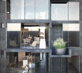
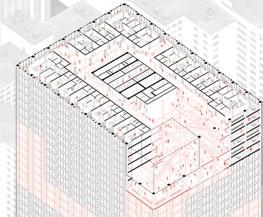
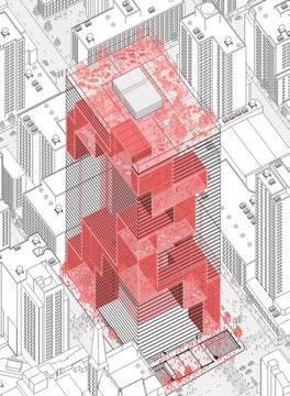
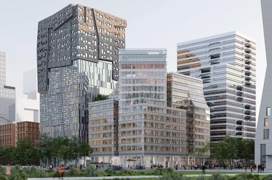
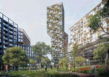
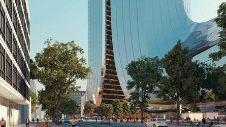
VERTICAL URBANISM TODAY
This global survey of 25 unrealized and as-yet unbuilt proposals takes the pulse of tall building design 25 years into the 21st century—revealing how architects and cities are adapting vertical form to meet the demands of climate, culture, and community. From hybrid timber structures and energy-storing towers to civic hubs and rewilded façades, these twenty projects chart divergent paths toward a more responsive vertical urbanism.
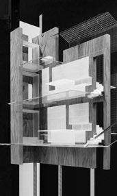
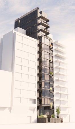
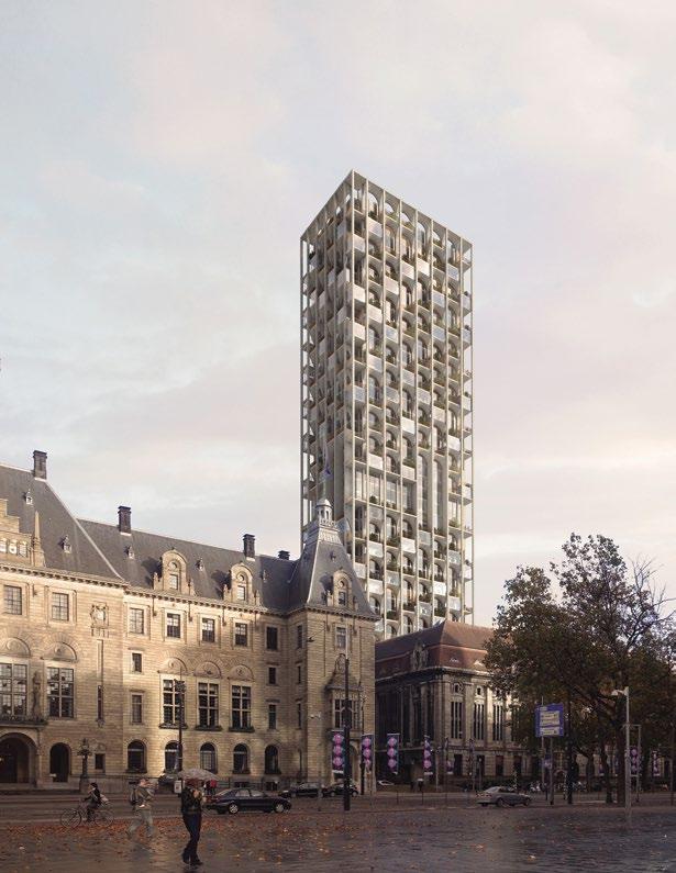
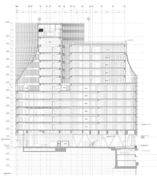
SHIGERU BAN ARCHITECTS TERRACE HOUSE VANCOUVER, CANADA
Terrace House, designed by Shigeru Ban Architects, is a contextual response to Vancouver’s urban and environmental sensitivities—an unrealized project that, at the time of its 2019 proposal, was set to become one of the tallest hybrid mass timber structures in the world. Comprising 20 residential units across 19 stories, the design explores how material innovation and vertical form can support a more sustainable model for urban density.
The building sits adjacent to a landmarked structure by Arthur Erickson, and its massing reflects a careful negotiation of its setting. Three key site constraints shaped the tower’s form: maintaining view corridors to the water and mountains, minimizing shadows on the adjacent park, and responding respectfully to its modernist neighbor.
The construction system pairs concrete for the podium, core, and primary tower with a timber structure for the building’s triangular upper volume. This apex becomes both a structural and symbolic gesture— highlighting the role of timber as a low-carbon material in high-rise construction. While unbuilt, Terrace House remains a critical case study in reconciling vertical growth with heritage, viewshed protection, and environmental performance in the context of a North American city.
WATERLINE AUSTIN, UNITED STATES
Rising 1,021 ft (311 m) above Lady Bird Lake, Waterline is poised to become Texas’s tallest tower and a defining element of the Austin skyline. Designed by KPF with HKS Architects as architect of record, this 2.3million-sq ft (213,678 m2) mixed-use development integrates hotel, office, residential, and retail programs into a single sculptural volume inspired by the flowing character of its namesake.
Set at the edge of downtown and the Rainey Street District, Waterline extends the public realm through a multi-level ground plane known as the Paseo—an activated streetscape of retail, restaurants, stone-clad columns, and landscaped terraces that connect directly to Austin’s first light rail line. The podium bends with the natural course of Waller Creek and wraps hotel functions around a concealed parking structure.
Above, the tower's form evolves through stacked and striated programs: office space gives way to hotel levels and then to residential units, all unified by deep balconies and a dynamic façade. Indoor-outdoor amenity spaces—lushly planted and porous in form—bring the character of the creek into the sky. Landscape architects TBG Partners and Nudge Design, along with interior designers Michael Hsu, Studio Mai, and Ink+Oro, contribute to a seamless integration of nature, texture, and city life. A new benchmark for vertical urbanism in the American South, Waterline reimagines density as a layered, accessible, and ecologically attuned urban experience.
DILLER SCOFIDIO + RENFRO PRD
MONTPARNASSE
PARIS, FRANCE
Originally conceived as a modernist gateway to Paris’s Left Bank, the Montparnasse hub was a bold experiment in postwar urbanism—a confluence of transit infrastructure, commercial programs, and public space.
Yet its heroic scale and detachment from the historic city failed to deliver on its promise of connection and vitality. Today, the site is fragmented and underutilized, with disorienting circulation, outdated commercial offerings, and a rooftop park—the Jardin Atlantique—largely hidden from public life.
Diller Scofidio + Renfro’s renovation of the PRD building—a 16-story office tower perched above the Montparnasse station concourse—seeks to align the site’s original ambitions with contemporary
urban priorities. The design retains the building’s general massing while introducing new spatial and structural interventions to better connect it to the city and the transit hub below.
At either end, the existing structural grid is demolished to create fully glazed volumes, requiring careful redistribution of loads and custom connection strategies. A new sawtooth glass façade reanimates the tower’s monumental form through light, reflection, and transparency.
A three-level amenity zone—linking a reconfigured lobby to a reimagined rooftop—improves circulation and layers tenant and public programs. The station podium is landscaped to create a more accessible garden, while a rooftop farm and restaurant crown the tower, forming a new green landmark for Paris.
Below— The proposal adds a three-story amenity zone for tenants, conceived as a "thickened" lobby.
Right— A 1960s office tower above Montparnasse station will be transformed into a contemporary hub for work, transit, and public life.
ELEMENTAL CUMBRE IXOU RESIDENTIAL BUILDING MONTEVIDEO, URUGUAY
Set along Montevideo’s Rambla Gandhi, Cumbre IXOU is a slender, seafront residential tower designed by Elemental, with executive architecture by Monoblock. Rising 47 m on a narrow 9-by-26-m lot, the 14-story building responds to its Atlantic-facing context with a structural clarity seldom achievable in earthquakeprone regions. With one apartment per floor—each 150 m2—the design maximizes ocean views while embracing flexibility and future adaptation.
Freed from the seismic constraints typical of Pacific construction, Cumbre’s structure is distilled to its most essential elements: a precise, lightweight skeleton pushed to the lot’s edges. This opens generous interiors and permits the horizon to permeate both front and back façades. A central skylight divides public and private spaces while drawing daylight deep into each apartment. Over time, units can shift configurations— expanding, contracting, or blending residential and work uses—as family needs evolve.
A 17-m swimming pool in the basement doubles as a fire reserve, while the rooftop offers shared recreational space, including a barbecue area and grill. Built in reinforced concrete, glass, aluminum, and wood, the tower exemplifies structural economy and spatial generosity. The practice describes the project as not only a coastal dwelling but a meditation on architectural permanence in dialogue with the changing lives it shelters.
Above—
Left—
This slender 14-story block has a single 150 m² apartment per floor.
The apartments offers views to the front and the back.
CHYBIK + KRISTOF BROADWAY ADAPTIVE TOWER
NEW YORK, UNITED STATES
Chybik + Kristof’s proposal for the Broadway Adaptive Tower reimagines Manhattan’s Paramount Plaza—1633 Broadway—as a model for post-pandemic urban reinvention. Responding directly to New York’s office vacancy crisis and urgent housing shortage, the design transforms the 48-story office tower into a vibrant, mixed-use vertical community. Originally built in the early 1970s, the tower retains its distinctive dark glass façade, now enhanced by a new ventilated loggia and second glass skin for improved thermal performance. Inside, the structure’s load-bearing core, columns, and envelope are preserved, while interior spaces are radically reconfigured to accommodate flexible residential units and shared livingworking environments. Modular partitions allow floor plans to evolve with occupants’ needs, supporting both private dwelling and communal activity. Prioritizing circularity, CH+K reuses original building materials: doors are refinished, carpets repurposed as acoustic insulation, and façade panels transformed into kitchen partitions. Shared amenities—including lounges, meeting rooms, and co-working spaces—remain active beyond conventional office hours, cultivating a dynamic, 24/7 atmosphere. With intelligent climate systems, a green roof, and passive ventilation strategies, the project advances both environmental and social sustainability. The Broadway Adaptive Tower establishes a forward-looking typology for global cities—where obsolete commercial buildings are reborn as resilient, self-sufficient ecosystems.
Above and below—
Axonometric drawings showing how the existing structure could be adapted to create internal connectivity.
Right, above—
The interior remodeling reveals itself to the city.
Right, below—
A triple-height communal space is inserted within the existing structure.
FARSHID MOUSSAVI ARCHITECTURE ZAC PORT
MARIANNERÉPUBLIQUE MONTPELLIER, FRANCE
Situated within the Port MarianneRépublique ZAC—a 12-neighborhood urban extension east of central Montpellier—Lot 1 Mixed-use Block is part of a major regeneration effort transforming former freeway-adjacent land into a dense, livable district. The broader plan introduces 1,800 housing units and new commercial infrastructure, with Lot 1 alone accommodating 4,100 m2 of office space, 2,000 m2 of housing (31 units), 314 m2 of retail, and a 450-m2 logistics center for local goods distribution.
Designed for long-term adaptability, the project confronts the uncertain future of domestic and office typologies. Levels 2 through 8 feature a consistent slab-to-slab height of 3.4 m offices
benefit from 2.7-m ceilings, while housing can enjoy up to 3 m. A 6-m structural grid supports a reconfigurable plan, complemented by vertically continuous service shafts and lift cores.
The façade, uniformly applied across the block, is articulated with a corrugated rhythm that modulates solar gain, provides privacy, and generates a variety of outdoor spaces. Whether configured for a single office tenant or multiple users, each floor is designed to maximize daylight and ventilation. Residential units follow the same grid logic, offering orthogonal plans and generous terraces— with some homes featuring up to five. As needs shift, the building’s program can evolve, ensuring long-term resilience. rapidly urbanizing context.
Right, below— Lower office floor plan.
Below— North elevation.
Right, above— Upper residential floor plan.
FOSTER + PARTNERS THE STAR LOS ANGELES, UNITED STATES
Unveiled as a transformative new presence on Sunset Boulevard, The Star is a US$1 billion creative office tower designed by Foster + Partners for Los Angeles-based developer The Star LLC. Sited on a 2-acre (0.8-ha) lot at 6061 W. Sunset Boulevard, the tower reimagines the future of workplace design for Hollywood’s dynamic creative and tech industries.
The building’s signature spiraling form is not only iconic in silhouette, but performative in experience: a series of landscaped terraces winds from street level to the rooftop restaurant, creating a continuous thread of outdoor environments for collaboration, wellness, and reflection. Generous floor plates, floor-to-ceiling glazing, and expansive views of downtown Los Angeles, the Pacific Ocean, and the Hollywood Sign reinforce its appeal as a landmark vertical campus.
Led by Norman Foster and Head of Studio Nigel Dancey, the design prioritizes adaptability, well-being, and community. Indoor and outdoor workspaces are seamlessly integrated to promote natural light, cross-ventilation, and a healthy, high-performance environment. Public amenities— including a theater, gallery, paseo of restaurants, and a civic plaza animated by an LED video screen—connect the building to its urban context, establishing The Star as both a workplace and cultural destination. Currently submitted for planning approval, The Star sets a bold precedent for 21st-century office typologies in Los Angeles.
The building's spiraling form creates a series of landscaped terraces, which wind from street level to the rooftop restaurant.
Left—
Left— View looking down on the spiral gardens.
PARALX BEIRUT DIGITAL DISTRICT MASTER PLAN BEIRUT, LEBANON
Situated between Beirut’s historic central district and the former civil war-era “green line,” the Beirut Digital District (BDD) master plan by Paralx proposes a new urban framework for the city’s digital and creative industries.
Designed to accommodate startups and small-to-medium enterprises, the plan reclaims a fragmented urban fabric by merging heritage structures with new vertical development.
Historic buildings on the site serve as anchors for the master plan, with virtual
lines projected from their façades to shape adjacent public space. This approach not only preserves architectural memory, but also organizes circulation and defines the spatial logic of the new district. The result is a series of volumes that fill in around these heritage focal points while responding to the grain of the existing city.
The plan is unified by three interconnected green piazzas that vary in scale and typology. These open spaces are central to a broader ambition: to transform a site once marked by division
into one of convergence. Verticality is used strategically to free the ground plane for public life and greenery, supporting a pedestrian-friendly environment in a city often short on open space.
The towers, conceived as “slab and glass,” use transparency to symbolically blur the historic divide. Rooftop gardens extend the public realm upward, offering semi-public gathering spaces with views of the city, sea, and mountains—creating a district that reflects both the past and aspirations for Beirut’s urban future.
Left—
The Beirut Digital District proposes a new urban framework for the city’s digital and creative industries.
Above—
Sited on the former civil war-era “green line,” the open spaces seek to transform a site once marked by division into one of convergence.
ODA POST ROTTERDAM, ROTTERDAM, NETHERLANDS
At the heart of Rotterdam’s city center, POST Rotterdam transforms a 1916 post office—one of the few buildings to survive the wartime bombing of the city—into a dynamic mixeduse complex. Designed by ODA, the project reanimates the historic Postkantoor as a hub of public life, integrating residential, hospitality, and cultural programs within and around the restored structure.
The 58,000-m2 scheme centers on the vaulted Great Hall, a monumental space rising 22.5 m, which has been meticulously restored as a civic interior.
A new entrance on Rodezand connects the building’s internal courtyard with this public hall, creating an open,
permeable ground level animated by shops, cafés, galleries, and restaurants.
Above, the upper floors of the original post office—once home to telegraph and telephone services—will become a five-star Kimpton hotel. At the rear of the complex, a 150-m residential tower rises from the courtyard. Its stone grid façade echoes the rhythm of the original building, while its varied window apertures frame views and draw in daylight, offering contrast to the glazed skyline emerging across the city.
Combining adaptive reuse with vertical growth, POST Rotterdam reasserts the post office as a central civic landmark—bridging past and present in one of Europe’s most forwardlooking cities.
Right— Axonometric showing the relationship of the existing building and the new tower.
Opposite—
View from Coolsingel with City Hall in the foreground.
MAD ARCHITECTS YANSONG QONDESA TOWER
QUITO, ECUADOR
MAD Architects’ debut project in South America, Qondesa Tower introduces a new paradigm of high-density, natureintegrated living to Quito’s evolving skyline. Set to become the tallest building in Ecuador’s capital, Qondesa emerges as both a residential landmark and a symbol of ecological aspiration, developed in collaboration with Uribe Schwarzkopf.
Rooted in Quito’s rich architectural and geological heritage, the tower draws inspiration from the surrounding Andean landscape and the historic stone façades of the city’s UNESCO-listed Old Town. Twisting vine-like forms wrap the building’s stone-colored exterior, giving rise to lush balconies planted with native vegetation. This dynamic, tapering form preserves views and natural light for neighboring buildings while establishing an organic presence on the skyline.
Across from La Carolina Park and adjacent to the Iñaquito Metro station, Qondesa is positioned to support walkable, transit-connected urban living. Its intimate residential units are supported by shared amenities and communal spaces designed to foster a vertical neighborhood—a community shaped as much by social interaction as by architectural form.
The tower integrates eco-efficient engineering, responsible energy and resource use, and comprehensive waste management. More than a structure, Qondesa embodies MAD’s vision of architecture as a living system—bridging nature, culture, and human experience in the vertical dimension.
ZAHA HADID ARCHITECTS SHENZHEN BAY SUPER HEADQUARTERS BASE,
SHENZHEN, CHINA
Tower C by Zaha Hadid Architects is a defining element within Shenzhen Bay’s Super Headquarters Base—a districtscale development positioned to serve the Greater Bay Area as a nexus for global business, technology, and culture. Now under construction, the nearly 400-m-tall, 440,000-m2 project is located at the intersection of the city’s north–south green axis and east–west urban corridor, forming a vertical gateway into a newly planned central park and transportation hub.
The design comprises two interconnected towers linked by sweeping bridges that house public programs and cultural venues with panoramic views. At ground level, a stepped podium integrates with surrounding landscapes and civic plazas, providing daylight and access to an
underground metro station and transport interchange. The building includes offices, a hotel, convention and exhibition spaces, and commercial amenities, forming a vertically layered, transitoriented development.
Advanced environmental systems are embedded throughout. A doubleskin glass curtain wall incorporates natural ventilation via operable cavities, while aquaponics gardens on terraced levels filter local air and water. The building targets low embodied carbon through material selection and recycling, and employs photovoltaics, greywater systems, and smart district energy management. Tower C is envisioned as a "superscape"—a hybrid of city and ecology—reflecting a new model of dense, climate-responsive urbanism.
RCR ARQUITECTES MURABA VEIL DUBAI, UNITED ARAB EMIRATES
Positioned between desert and sea, Muraba Veil is a 380-m residential tower designed by Pritzker Prize–winning RCR Arquitectes in collaboration with developer Muraba. Conceived as a response to both place and climate, the 73-story tower proposes a quieter, more adaptive model of high-rise living in a city defined by spectacle. Its unusually narrow profile—just 22.5 m wide—allows each of the 131 residences to span the full depth of the building, offering dual-aspect views and natural cross-ventilation.
A stainless steel mesh “veil” wraps the structure, filtering light, modulating heat, and creating a layered visual experience that evokes the mashrabiya while dissolving the tower’s silhouette into sky. According to RCR, the veil is “as much draped as it is built”— a counterpoint to the hard-edged typologies that dominate Dubai’s skyline. Inside, the building is organized around a reinterpretation of the traditional Arabian house, moving from shaded entry to open interior courtyard. Outdoor terraces flank both sides of each unit, and a subterranean wellness complex—set beneath a dune-like podium—extends the building’s sense of retreat. Muraba Veil aims to recalibrate the skyscraper to the desert, using massing, material, and passive design to create a contemporary sanctuary rooted in regional vernacular.
The 22.5-m-wide building enables all apartments to be dual aspect.
Outdoor terraces flank both aspects of the apartment.
The subterranean wellness complex has an organic form.
Right—
Above—
Left—
Left— Level 0, showing the entrance sequence.
Left— Level -1, showing the subterranean wellness complex.
Left— Levels 70–71, showing the pools and restaurant.
Left— Levels 68–69, showing the five-bedroom duplex.
CH500 explores the limits of the high-rise typology through a combination of geometric regularity and structural distortion. Designed by Mexico City–based Michan Architecture, the tower presents as a pristine rectangular volume that splits at its base into four inclined legs—opening the ground plane to the city and forming a public plaza that mediates between building and street. The legs create a porous threshold and accommodate distinct functions: two contain commercial programs, while the others serve as structural cores, one linking to underground parking and the other providing vertical circulation throughout the tower.
According to the practice, the project “deals with the familiar and unfamiliar,” beginning as a rational box and becoming subtly deformed where it meets the ground. This distortion is also articulated in the façade, which transitions from a uniform blue grid at the top into a warped geometry that mirrors the base’s structural shift. The tower’s structural system relies on reinforced concrete in both the legs and façade, enabling column-free floor plates above. Designed for a site along Avenida Chapultepec, CH500 is intended to serve as “a catalyzer for the reactivation” of this key corridor, inviting public engagement while testing new possibilities for vertical urban form.
Above—
The split base creates a porous undercroft, drawing pedestrians into a shaded public plaza beneath the tower’s elevated mass.
Right— Seen from Avenida Chapultepec, the tower’s rectilinear form reveals a subtle distortion at its base, where four inclined legs open the volume to the city.
99 BISHOPSGATE
LONDON, UNITED KINGDOM
Set to redefine the northern gateway to the City of London, 99 Bishopsgate is a 54-story office tower designed by RSHP and developed by Brookfield. The scheme comprises over 1 million sq ft (92,900 m2) of office space alongside more than 60,000 sq ft (5,574 m2) of cultural and public amenities. A key component of the project is the introduction of a new seven-day City Market and improved pedestrian connections between Liverpool Street Station and the financial core.
Sustainability is integral to the design: nearly half of the existing foundation system will be reused to reduce embodied carbon, and vertical
gardens are integrated throughout the tower to promote urban greening and occupier well-being. The project also includes Open Gate, a six-story cultural venue with space for performance, exhibitions, and creative production.
Projecting an £8.5 million (US$11 million) boost to the local economy annually and the creation of over 7,500 jobs, the project represents a significant investment in the social and economic fabric of the City. Gaining unanimous planning approval in January 2025, the development reflects a broader shift toward mixed-use vertical typologies that combine workplace, culture, and public realm within a high-density urban setting.
RSHP
RSHP
Left— 99 Bishopsgate in the context of the City of London.
Below—
The winter gardens have far-reaching views across the capital city.
SAUERBRUCH HUTTON ALEXANDERPLATZ MIXED-USE DEVELOPMENT BERLIN, GERMANY
This mixed-use project at Alexanderplatz comprises two interrelated structures: a nine-story plinth and a high-rise tower. While the plinth aligns with the surrounding urban fabric in terms of height, materiality, and façade articulation, the tower contributes a new vertical impulse to Alexanderplatz’s evolving skyline. Together, they form a composition that reinterprets the traditional European mix of living, working, and commerce into a contemporary, vertically integrated format.
The vitality introduced by shops, restaurants, and co-working spaces animates the urban realm and is echoed in the large-scale striped awnings that shade the lower façades, lending an ephemeral quality to the streetscape. Shared amenities—including clubrooms adjacent to a rooftop garden and a fitness
area on the eighth floor—foster interaction among residents, who inhabit the upper six stories of the plinth and also enjoy access to a courtyard garden.
The tower primarily houses office space and is articulated as a pair of slim vertical volumes. A two-layered façade combines chromatically differentiated climate shells with outer screens composed of photovoltaic elements and solar shades. Wind-protected openings allow for natural ventilation, while geothermally sourced systems provide heating and cooling. All rainwater is harvested and stored, and operational carbon emissions are minimized.
Anchoring one of Berlin’s most symbolic urban sites, the project references the area’s historical significance while signaling a future of active, energy-responsive architecture.
Right— The scheme addresses the public space of Alexanderplatz.
Opposite— Section: the plinth accommodates retail, restaurants, and co-working spaces on its lower levels, with six floors of housing above.
Below—
The context—in particular the 1929–32 gateway to the platz by Peter Behrens—sets the scale of both podia and towers to provide a legible urban order that reinforces both the spatial qualities and the character of Alexanderplatz.
SERIE ARCHITECTS TOWER OF TABLES, SINGAPORE
Tower of Tables reimagines the high-rise office as a vertically stacked series of pavilions, designed to accommodate flexible work environments in a tropical context. Developed as a competition proposal by Serie Architects with Multiply Architects and Architects 61, the 75,000-m2 project challenges conventional high-rise typologies with a compartmentalized structure composed of four- to six-story “workspace communities,” each framed by lush landscape terraces.
The looping podium plan encircles a central forest courtyard, populated with four circular breakout pavilions, creating informal gathering zones and improving microclimate conditions. The building integrates mass-engineered timber (MET) into its hybrid steel-timber structure to
reduce embodied carbon. Each pavilion or “table” is supported by a steel frame and core, while intermediate floors are timber-based, contributing to a carbonneutral tower.
Passive design and adaptive cooling strategies replace conventional HVAC systems, allowing for efficient, flexible floor plates. The façade maximizes daylight while minimizing solar gain and glare. Photovoltaic panels embedded in the shading system and rooftop surfaces generate approximately 20% of the tower’s energy, while the podium is designed to operate at net-zero energy.
With its material-conscious design, modular layout, and responsiveness to climate, Tower of Tables presents a new prototype for high-rise commercial architecture in equatorial regions.
Right— The project conceives the high-rise office as vertically stacked pavilions.
Above, right— Interior view looking at the central forest courtyard, with circular breakout pavilions.
Left— Morning view across the podium to the tower.
Below—
Exterior view.
Right—
Structural model.
Using 13,000 m3 of sustainable wood, the building sequesters 9,000 t of carbon.
SO–IL CUBEHOUSE AMSTERDAM, NETHERLANDS
Currently under construction, CubeHouse is an office project in Amsterdam’s Zuidas district that bridges infrastructure, sustainability, and workplace design. Sited atop an existing parking structure, the building connects its subterranean base to an intricate volume above through a robust structural frame—a gesture inspired by the myth of Atlas, evoking both resilience and balance. The design introduces “breathe spaces,” temperate microclimates situated between the building’s outer façade and its more restrained inner shell. These interstitial zones support natural ventilation, daylight, and vegetation, expanding the traditional boundaries of the office and contributing to well-being.
Sustainability is central to the scheme: 75% of the primary structure is composed of circular materials, including 13,000 m3 of sustainable timber, projected to sequester 9,000 t of CO2. Photovoltaic panels across the façade and roof are expected to generate 138,000 kWh annually—covering approximately 80% of the building’s energy demand. Rainwater collection and a greywater system further reduce environmental impact, while a public garden introduces biodiversity to the dense urban fabric.
Informed by SO–IL’s humanistic and civic-minded approach, CubeHouse advances a new model for vertical architecture—open, ecological, and socially engaged.
Above— North-south section, highlighting the “breathe spaces” —temperate microclimates situated between the building’s outer façade and its more restrained inner shell.
STUDIO GANG ASSEMBLE CHICAGO CHICAGO, UNITED STATES
Assemble Chicago is a carbon-neutral, mixed-use high-rise designed by Studio Gang in collaboration with The Community Builders. Winning the C40 Reinventing Cities competition, the project reclaims an underutilized site at Van Buren Street and Plymouth Court in Chicago’s Loop. It proposes a new civic model for post-carbon, post-pandemic urban living—combining affordable housing, social infrastructure, and public realm renewal.
The 20-story building includes 207 residences for moderate- and lowerincome households earning 30–80% of the area median income. Each unit features a contemporary interpretation of the Chicago bay window to maximize daylight and ventilation, while the vertically
articulated façade references the Loop’s historic architecture through modern materials and energy-efficient detailing.
At the base, the multilevel NeighborHub will offer space for cultural programming, community services, minority-owned businesses, and health amenities—extending into a revitalized Pritzker Park. The park and building are conceived as a continuous civic space linking indoor and outdoor environments. Targeting LEED Platinum and LEED Zero certification, the project incorporates passive strategies, renewable energy systems, urban gardening, and biophilic design. The scheme demonstrates how climate-responsive architecture can also address housing equity and community cohesion at the center of the city.
Above—
View from Chicago’s famous L train, of an earlier scheme with a more textured surface treatment.
Right— Current scheme, showing the neighborhood hub.
SOM ENERGY VAULT TOWER CONCEPT PROJECT
The Energy Vault Tower redefines the relationship between infrastructure and urban form by embedding a gravity-based energy storage system within a 500-m residential high-rise. Developed with Energy Vault, the tower stores renewable energy by lifting dense weights to the top of the structure during off-peak hours and releasing them to generate electricity when demand is high—transforming the building into a vertical battery for the city.
Residential units are arranged around the perimeter of the tower, offering abundant daylight, outdoor terraces, and expansive views. These homes wrap a central energy core, turning what is typically peripheral infrastructure into the architectural heart of the project.
The tower’s hybrid approach speaks to the growing need for energy-resilient urbanism in dense, high-growth contexts. It challenges the conventional separation of utility and lifestyle, proposing instead a synthesis of clean energy production and high-rise living. The building’s structure is optimized for both performance and livability, offering a prototype that combines density, sustainability, and architectural clarity.
The Energy Vault Tower presents a compelling vision, where architecture does not merely consume resources, but actively stores, generates, and manages them as part of everyday urban life.
Right— Indicative tower section.
Designed
the collaboration reimagines high-rise living as renewable infrastructure— integrating gravitybased energy storage, residential units, and thermal systems into a single, selfsupporting urban form.
by SOM with Energy Vault,
OXMAN EDEN TOWER CONCEPT PROJECT
The EDEN Tower proposes a new architectural paradigm: a high-rise structure not as an isolated object, but as a functioning ecosystem. Developed by OXMAN, the project operates at the intersection of architecture, environmental science, and generative design. Its aim is to reverse the typical dynamic between the built environment and the natural world, positioning the tower as an ecological agent—delivering biodiversity, resilience, and ecosystem services in a vertical format.
Using a platform of data-driven, generative optimization—ranging from reinforcement learning to neural-field modeling—the EDEN design process begins by gathering site-specific ecological data, including species needs, climate, and soil conditions. This information guides the formation of a “computational rulebook” that shapes the tower’s structure, programming,
and materiality. The result is a vertically layered system where human and non-human programs are interdependent. The tower integrates natural habitats such as meadows, forests, and wetlands into its skin and structure. Structural logic is coupled with ecological logic: a central truss stabilizes the tower while suspending lighter levels below and supporting denser ecosystems above. Sloped surfaces collect water; plantings contribute to air purification and carbon sequestration. Transparent interior zones host cultural and educational functions, while interstitial areas generate material resources such as timber and fiber.
As a case study in “ecological programming,” EDEN challenges conventional sustainability metrics by striving not for net-zero impact, but for net-positive environmental contribution. It is both building and biome—a vertical experiment in rewilding architecture. Opposite— Eden
Tower in an urban context.
Early sketches of Eden Tower.
Map distributions,
Above—
Map distributions, from
Top—
from left: solar, rainfall, wind speed, energy.
left: grassland, meadow/grotto, shrubs, forest.
Right, above— Floor plan, constructed grotto.
Right, below— Floor plan, constructed meadow.
0 5 1 FLOOR PLAN IN A CONSTRUCTED GROTTO
0 5 1
WOHA & ARCHITECTUS CAIRNS STREET
BRISBANE, AUSTRALIA
Located at Kangaroo Point on the site of the historic Evans Deakins Dry Dock, Cairns Street is a residential development that merges contemporary design with Brisbane’s subtropical identity. Designed by WOHA, the tower reflects the city’s emphasis on sustainability, livability, and public realm enhancement, aligning closely with Brisbane’s “Buildings that Breathe” planning framework.
The twin towers rise 20 m above the ground, supported by a landscaped podium that preserves pedestrian connections across the site. Their elevated position ensures generous light, air, and views for both residents and the surrounding public gardens. Garden lobbies link the towers at each
Right, above— Section.
Right, below— Apartment level floor plan.
level, enabling cross-ventilation and social interaction, while silver mesh fins provide shade and filter sunlight across the glazed façades.
At ground level, the Dry Dock Gardens reinterpret the site's industrial legacy through lush plantings and layered terrain. These gardens serve as a connective civic landscape— providing spaces for rest, play, and gathering, while embedding memory and ecology into the daily life of the city.
With solar energy systems, shaded communal spaces, and a strong relationship to site and history, Cairns Street presents a model for subtropical high-rise living rooted in climate responsiveness and cultural continuity.
Above—
A landscaped podium preserves pedestrian connections across the site.
Right— The building is at the site of the historic Evans Deakins Dry Dock.
URBAN-THINK TANK FRONTIER URBANISM, CONCEPT PROJECT
Amid New York City’s ongoing housing crisis, calls for increased density frequently run up against regulatory inertia, entrenched land-use patterns, and resistance to change. In response, UrbanThink Tank (UTT) proposes a model of frontier urbanism—a framework for vertical growth that embraces informality, adaptability, and sustainability as essential design principles, not exceptions. Rather than treating high-rise construction as a purely formal or technological pursuit, this approach begins with urban realities: mismatched needs, underused lots, and the growing demand for housing that is affordable, connected, and resilient.
Inspired by Torre David—an unfinished office tower in Caracas that became home to over 750 families— UTT reconsiders the skyscraper not as a symbol of top-down planning but as a scaffold for bottom-up urbanism. The project articulates a 10-part Urban Toolbox of strategies that can be deployed across contexts, enabling cities to grow vertically without relying solely on capital-intensive development models.
Right—
A city as a framework that allows conflicting urban forces to engage in a productive coexistence with integrated mobility and vertical infrastructure.
Below—
A contemporary city to engage a fully three-dimensional field of mobility, introducing new pathways and services that allow dense verticality to support a wide variety of programs by connecting buildings.
Key components include lowcost, modular elevator systems that operate like vertical public transit; decentralized energy and water systems that turn buildings into self-sufficient infrastructure; and design frameworks that support incremental, modular housing growth. Underutilized rooftops, alleys, and façades become active zones of public and commercial life, extending the building’s role beyond its footprint. Crucially, these strategies are designed to integrate with existing transit and utility networks, resisting the isolation often associated with vertical enclaves.
Rather than imposing a fixed skyline, frontier urbanism invites cities to build up slowly, responsively, and with greater spatial and social diversity. It provides a pragmatic path forward for high-density urbanism—particularly in cities where land is scarce, resources are constrained, and the need for affordable housing is urgent. In UTT’s vision, verticality is no longer just a marker of ambition; it is a tool for equity, ecology, and participation.
Below— Building block extrusion for a connected rooftop park in Sao Paulo’s neighborhood of Glicerio, which proposes a new kind of block extrusion to devise innovative housing and connected green social infrastructure.
SHOP ARCHITECTS & BVN ATLASSIAN CENTRAL SYDNEY, AUSTRALIA
Currently under construction in Sydney’s Tech Central precinct, Atlassian Central is set to become the tallest commercial hybrid timber tower in the world. Designed by SHoP Architects with BVN, the 39-story building proposes a new model for sustainable high-rise development—merging mass timber construction, modular flexibility, and energy innovation to reflect Atlassian’s values around climate action and workplace culture.
The tower’s hybrid structure combines a steel exoskeleton and concrete core with 21 freestanding mass timber floors organized into seven “habitats”— each a four-story volume suspended within the megaframe. This layered assembly enables future adaptability across the building’s lifespan and provides discrete, interconnected work
environments that emphasize wellness, light, and acoustic comfort.
Taking advantage of Sydney’s mild climate, the design incorporates naturally ventilated and semi-conditioned spaces, operable façades, and large planted terraces staggered along the tower’s height. Photovoltaics, daylight shading, and energy-efficient systems target a 50% reduction in both embodied carbon (A1–A3) and operational energy compared to conventional benchmarks. The building will run entirely on renewable electricity from day one.
Targeting 5.5 Star NABERS Energy, 6 Star Green Star, and Platinum WELL ratings, Atlassian Central positions sustainability not as an add-on but as a structural and spatial driver— offering a compelling prototype for the post-carbon commercial tower.
Right—
In Sydney’s Tech Central precinct, Atlassian Central is set to become the tallest commercial hybrid timber tower in the world.
Above— Habitat façade detailing.
Below— The lowest level of each habitat is naturally ventilated and work enabled.
Right, above— View of the skyrise terraces.
Right, below— Diagram of habitat ventilation strategy.
C Naturally ventilated: Unconditioned space
B
Naturally ventilated: Conditioned with fans and perimeter heating
Mechanical ventilated: Minimal use of ducts, use of fans, chilled beams
Stack effect
Type
Type
Type A
STEFANO BOERI ARCHITETTI URBAN OASIS MASTER PLAN BRATISLAVA, SLOVAKIA
Stefano Boeri Architetti’s Urban Oasis master plan reimagines a 3-ha site in central Bratislava—once home to factories and heavily bombed during WWII—as a vibrant, green district anchored by a public park. Situated within the Chalupkova development zone, the 32,500-m2 triangular plot includes five new buildings— one tower and four mid-rise blocks —arranged around a central, open park accessible to all.
The master plan emphasizes permeability, light, and livability. Varied building heights allow sunlight into the park, while terraces and loggias provide both private and shared outdoor spaces. On the ground level, retail and public functions activate the park edge, fostering a dialogue between community life and residential use across 1,200 housing units with diverse typologies.
The design mitigates noise from surrounding traffic through curved façades, green buffers, and strategic orientation. Vegetation plays a dual role, offering biodiversity and natural sound absorption. Green roofs, shaded courtyards, and a surrounding ecological ring strengthen connections to Bratislava’s broader green infrastructure.
Prioritizing pedestrians and cyclists over cars, the plan incorporates continuous paths and integrates urban drainage and solar energy systems. Urban Oasis proposes not just a neighborhood, but a new model for climate-responsive, socially inclusive, and ecologically connected urban renewal.
Left— View of the scheme from the street.
Below— View of the tower from the shared central public space.
Positioned at the threshold of a national transport hub and the terminus of a “City Garden Corridor,” Ascension: Hyperlinked Gateway proposes a new civic landmark for an emerging city. The project imagines infrastructure not as a backdrop but as a catalyst—connecting people, places, and timelines through movement, culture, and collective imagination.
Two ascending towers rise from a shared plinth, forming a symbolic gateway that bridges the urban and the natural. Below, a new public space invites gathering and exchange; above, the towers extend toward the sky, marking entry into the networked flows
of high-speed transit. Inspired by the simplicity of rail lines and the complexity of contemporary urban systems, the project transforms connective infrastructure into architectural form. This is not merely a portal for transit but a spatial hyperlink—anchoring the city in place while opening it toward future horizons. The design reflects a belief that cities grow not only through expansion, but through symbolic acts of reconnection: between nature and structure, past and future, individual and collective. Ascension becomes a point of departure and arrival—where movement becomes memory, and infrastructure becomes identity.
Above—
The project envisions towers as reflective, glowing, extruded forms.
Position—
Two towers arc toward each other to create a symbolic gateway.
REBUILDING WORLD TRADE CENTER
The reconstruction of Lower Manhattan after 9/11 was an extraordinary feat of resilience and vision. In February 2025, NYU’s Schack Institute of Real Estate convened the leader of the effort and a scholar who chronicled the quarter-century transformation.
ROSEMARY SCANLON is former chief economist for the Port Authority and dean at the NYU Schack Institute of Real Estate. She co-authored 20+ Years of Urban Rebuilding with Patrice Derrington.
LARRY SILVERSTEIN is chairman of the developer Silverstein Properties and founder of the Schack Institute of Real Estate. He authored The Rising: The Twenty-Year Battle to Rebuild the World Trade Center.
CHAIR
MARC NORMAN is the associate dean at the NYU Schack Institute of Real Estate. An expert in urban development and finance, he leads conversations on city-building and resilience.
The photographic essay of Lower Manhattan is by Joe Woolhead (pages 79–95).
This discussion has been edited for concision and clarity.
Marc Norman My first question is for Larry Silverstein. When you signed your agreement to take over the World Trade Center in 2001, you were taking on a project that encompassed ten million square feet of office space, a shopping mall, and a hotel—many of its uses mandated by agreements between the Port Authority, the city, and the state. You signed the lease under certain parameters, but soon after, you faced an entirely different reality. Can you share with us how 9/11 reshaped your vision?
Larry Silverstein The reality of 9/11 transformed everything—certainly in my life and in the lives of millions of others. The World Trade Center was totally destroyed, and it became immediately clear to me that rebuilding had to happen as quickly as possible.
When I signed the agreement in 2001, it stipulated that if anything happened to the property—whether by fire or any other cause—I was required to rebuild as soon as possible, to the same quality and specifications. That contractual obligation remained, so once everything was destroyed, there was no question that we had to replace what was there.
At the same time, it was impossible to ignore the fact that certain aspects of the original Trade Center were unpopular. That realization shaped our approach. We had 10 million sq ft (929,000 m2) of office space that needed to be rebuilt, retail space that needed to be restored, and a hotel that had to be reconstructed. We were contractually bound to rebuild, but we couldn’t simply replicate what had
been there before. If we were going to rebuild the Trade Center, we had to do it in a way that truly reflected people’s needs and desires.
For example, when the Port Authority originally assembled the land for the World Trade Center, it condemned 17 or 18 acres (6.9 to 7.3 ha) of property, eliminating what had once been Radio Row. Before that, people could drive and walk freely through the area. But once that land was consolidated for the Trade Center, those streets disappeared, and many people resented that loss. In the early stages of rebuilding, we had to consider whether to keep the site as it was or reintroduce the street grid. That was one of the fundamental discussions we had from the very beginning. Ultimately, our goal was to rebuild a better New York on that site—not just to restore what had been lost, but to create something far superior. And so, we got to work. I’d like to think we did a good job. I hope everyone agrees.
MN Rosemary, in your book, you interviewed a wide range of people who were integral to this process. When you consider not only 9/11 but also the global financial crisis less than a decade later, competition from Midtown, and all the other challenges—changes in mayors and governors, shifting political landscapes— there were so many potential impediments to rebuilding. I’d love to hear your perspective, as well as of those you interviewed: What were the key lessons about getting the transformation of Lower Manhattan done?
Rosemary Scanlon One of the central aspects of my book—co-authored with Patrice Derrington—was to explore these lessons in depth. When we set out to write it, we had several key missions. One was to examine the economy of Lower Manhattan before 9/11. It’s important to note that after the first bombing of the World Trade Center in 1993, the Lower Manhattan office market was in terrible shape. At that time, Carl Weisbrod, who led the Downtown Alliance Business Improvement District, and Mayor Rudy Giuliani, during his first year in office, implemented a critical policy called 421-g. This policy incentivized the conversion of older office buildings— many of which were constructed in the 1920s—into residential buildings. Frank Sciame [CEO, Sciame Construction] is quoted in our book, saying that these buildings were ideal for residential conversion because they had “flowthrough layouts and great natural light.”
Patrice and I conducted interviews with at least 30 people. We asked each of them, from architects and developers to planners, to write their reflections. The final contribution in the book is from Larry Silverstein, which serves as a wonderful capstone to the project. Another unique aspect of the book is the photography. Many of the images are by Joe Woolhead, who serves as Larry’s photographer [whose photographs illustrate this feature]. His work adds another layer of depth to the narrative. Regarding the stumbling blocks in rebuilding, we should turn to Larry—he had to navigate those challenges firsthand.
Left—
The discussion in progress. From left: Larry Silverstein, Rosemary Scanlon and Marc Norman.
Right— Opening of 7 World Trade Center, May 2006.
OLIVO, NYU PHOTO BUREAU
LS Shortly after 9/11, we saw major corporations picking up and leaving downtown because their office space was no longer usable. Thousands of Battery Park City residents also left. The air quality was terrible, the smells were awful—everything felt unlivable. At a certain point, the prevailing sentiment seemed to be, “For the last one out, please turn off the lights.”
We heard from so many people that no one would ever return. They said, “People will never come back. This place is finished.” Rudy Giuliani, who was mayor at the time, advocated for preserving the entire area as a memorial. When I heard that, I sat down and thought about it. Then I told him, “You’re 100% wrong.”
He asked why, and I said, “Look, you’ve got 12 mass transit lines converging here. You can get anywhere in the city from this point. That’s invaluable. The World Trade Center was the economic engine of Lower Manhattan. It was the locomotive that kept business activity moving. It wasn’t just an office complex— it was an attraction, a hub of constant economic flow. If we don’t rebuild, it will become a ghost town.” So I told him, “Forget about this idea—it’s completely defeatist.” But it wasn’t just him. I kept hearing from people who insisted, “It’ll never happen. No one will return.”
By August 2002, though, we held our first meeting with Skidmore, Owings & Merrill to design the new 7 World Trade Center. I said, “Let’s go. Let’s get it done.” And that was the beginning.
Looking back, there were so many challenges. In 2005, The Wall Street
Journal ran an article quoting Mayor Michael Bloomberg, who said, “Silverstein is hurting the rebuilding of the Trade Center by charging outrageous rents.” I immediately called him and said, “Mayor Bloomberg, you’re saying I’m charging outrageous rents? I’m charging US$50/ft2 (US$538/m2)— that’s the market value.”
He responded, “Mr. Silverstein, that space is worth no more than US$35/ft2 (US$377/m2)” I said, “Mr. Mayor, I’ve spent my life leasing space in Manhattan. I know what the values are.”
He replied, “Prove me wrong.”
So I did. We signed a lease with Moody’s for 800,000 sq ft (74,322 m2). The very next day, my phone rang. It was Mike Bloomberg. He said, “Larry, I’m calling to apologize.”
I asked, “Apologize for what?”
He said, “You proved me wrong.” I told him, “Mr. Mayor, you are an extraordinary human being for making this call. You have better things to do with your time, but the fact that you’re doing this—it’s incredible.” Then I asked, “Would you say that publicly?”
He laughed and said, “I’m not going to do that.”
At the end of the day, we knew the values were there. We believed in what we were doing. We knew that if we built a first-class, state-of-the-art building, people would come back. And we also knew that the first building to rise after 9/11 had to be the safest ever built in America.
We spent the money, did what needed to be done, and ensured it was
indestructible. Once that was established, everything else started to fall into place.
RS Larry still had to fight many battles with people in the city who insisted there was no market for 10 million sq ft (929,000 m2) of office space. But then there were key figures, like John Kelly and Marianne Tai, who said, “Wait a moment.” This was in 2006 and 2007, and they testified that, no, this would work. And of course, it did. This was an enormous lift—to rebuild after 9/11—but Larry made it happen.
LS They told us we would never lease it. They told us we would never finance it. They told us we could never complete it. One naysayer after another. At a certain point, I said to myself, “Don’t listen to those people. What do they know?” I was going to put in the money, the effort—I was going to get this done and prove that this would be the best building ever built in America.
MN Well, I think the real takeaway is that you can say “no” to both Rudy Giuliani and Michael Bloomberg— and prove them wrong. That’s the next book. But, to Rosemary’s point, the 421-g policy wasn’t just about rebuilding the Trade Center, it was about rethinking downtown.
Office-to-residential conversions, which Silverstein has been involved with, reinserting the street grid, and creating neighborhoods rather than just office districts—these were fundamental shifts.
And now, 24 years later, these same conversations are still happening. The lessons from Lower Manhattan and the World Trade Center resonate around the world.
RS When I first started working downtown in 1969, and then the 1970 census came out, there were only 2,000 people living south of Chambers Street. That was it. Now, at least 65,000 people live here. It’s an amazing transformation. Now 27% of the people who work down here also live down here. It’s the highest work-live ratio in the United States by far. The population growth has been phenomenal. It’s really remarkable.
And it has finally turned Lower Manhattan into a 24/7 city. We have hotels, Michelin-starred restaurants— it’s all here now. Having lived through it, I can say firsthand that no one believed this would happen after 9/11.
At the time, people were leaving other parts of the city, and no one thought this area could be cleaned up, rebuilt, and inhabited again. If you go back and look at the New York Times or Wall Street Journal stories from 2002 to 2004, you’ll see just how much debate there was about what should be done.
There was constant fighting over what Lower Manhattan’s future would be, what Larry would be allowed to do, and how much control he would have. In the end, he just pushed forward and did what he was going to do anyway.
LS It wasn’t easy.
MN But some of the lessons from this process seem especially relevant today. When you think about the recent wildfires in Los Angeles or other largescale disasters, rebuilding after devastation isn’t just about reconstruction—it’s about cleaning up, gaining consensus, possibly changing legislation, and even rethinking how we build. Do you think there are lessons from Lower Manhattan’s recovery that could be applied to the increasing number of disaster-stricken districts that will need to be rethought or rebuilt?
LS There are many lessons that could be taken from what we accomplished here. I think the most important thing is to give people what they want—not what you want as a developer.
That means providing first-class office space, first-class residential space, and first-class amenities—restaurants, bars, cultural spaces—things that people truly enjoy. Those make all the difference in the world. If you give people what they want, you’ll attract them. And that’s the foundation for regrowth and redevelopment in places that need it. All anyone has to do is look at what we did here and replicate it elsewhere, because it works. It worked here, and it can work anywhere. Today, we have so many major corporations moving here. One of the biggest reasons is the young community—young, well-educated people in high-responsibility positions. And they have everything they could possibly ask for: great restaurants, bars, and now, a world-class performing arts center.
Right— Foundations for One World Trade Center, photographed in 2007. Designed by David Childs of Skidmore, Owings & Merrill, the tower would become the tallest building in the Western Hemisphere upon completion in 2014.
Mike Bloomberg—God bless him—was responsible for bringing the [Perelman] Performing Arts Center to the Trade Center site, and he’s done a fantastic job. Most people have no idea how much he’s given to these efforts, but it’s extraordinary.
The presence of a performing arts center like this is transformative. It’s an illuminating experience to attend a performance there—people love it. And it’s right here, at our front door. When you create a variety of opportunities like this, particularly for young professionals, corporations take notice. That’s why so many companies want to be here— because the people they want to hire already live here and love it.
Lower Manhattan has become a true 24/7 community.
RS And there are other magical aspects of what you’ve rebuilt too. Just stand inside the Oculus and watch visitors as they walk in and look around. It’s breathtaking. In New York, the only other space like it is Grand Central Terminal, but downtown, we have the Oculus—very different, but absolutely magical in its own way. The architecture, the design, the way it carries through—it’s stunning.
Then there are the Memorial Pools, designed by the young architect Michael Arad, with Peter Walker. Every time I see them, my jaw still drops.
LS At one point, I was faced with a big decision—how to choose the architects for these buildings. I thought about it and
said to my wife, “Sweetheart, let’s travel. Let’s go see the work of world-class architects firsthand.”
We traveled to Japan and other places to study different architects’ work. I remember being in Tokyo, where we met Fumihiko Maki, a minimalist architect who had won numerous prestigious awards. His designs were spectacular—just beautiful. I remember saying to my wife, “We’ve only been here 16 hours, but we’ve learned so much. It’s magnificent.” She agreed—it was gorgeous. We chose him to design Tower 4.
In Germany, we saw the work of Norman Foster—exquisite. We selected him for Tower 2. Then, we chose Richard Rogers for Tower 3—another incredible talent. All three Pritzker Prize-winning architects, world-class in every respect.
And then, of course, [SOM’s] David Childs had already done an extraordinary job for us on 7 World Trade Center, so we asked him to design One World Trade Center, the Freedom Tower, as well.
What we ended up with was an assemblage of some of the world’s greatest architects. Working with them was an extraordinary experience. As a developer, you can’t ask for better—to collaborate with first-class creative minds, people with deep sensitivity and a commitment to beautiful, high-quality design.
What was fascinating was how they constantly worked to perfect their projects. They would refine something until it was absolutely flawless—then go back and improve it again and again. I remember when Tower 3 was nearing
Right— Topping-out ceremony for 4 World Trade Center, 2012. Designed by Fumihiko Maki, 4 World Trade Center was the first tower to be completed on the rebuilt World Trade Center site, marking a major milestone in Lower Manhattan’s post-9/11 transformation.
An iconic view of Lower Manhattan from 2013, with the Statue of Liberty in the foreground. The World Trade Center towers define the skyline.
completion. We had already purchased all the materials—the marble, everything. Then I got a call from Richard Rogers. He said, “Larry, I’m coming to New York. I need to see you.”
I asked, “What’s going on?”
He said, “I need to make some changes.”
I told him, “Richard, we already own all the materials. What changes do you want to make?”
He said, “Larry, I think I can do a better job.”
I thought, “Oh my God, what’s going to happen now?”
When he arrived, he showed me his new proposal—and somehow, I don’t know how, but by God, he really had made it better. We ended up replacing materials we had already bought because his redesign was that much stronger.
When you work with architects of this caliber, you experience firsthand their relentless drive to push their own limits. They keep improving, always making things better. It was one of the most rewarding experiences of my life.
RS Larry, I can’t continue without mentioning the Port Authority, where I worked for 24 years. Back in those days, I think you were working on 120 Broadway—in the late 1970s. You used to hold breakfast meetings, and one day, you called up someone you knew at the Port Authority. They decided to send an economist over, and that’s how we met.
At the time, New York was just beginning to emerge from that terrible seven-year recession. Although the numbers weren’t showing it yet, there were only two optimists in the room— you, Mr. Silverstein, and a young economist, me. And we were right.
Bringing this back to the Port Authority, one of the things that really stood out when we worked on this book was the sheer scale of what had to be rebuilt. We interviewed [Port Authority construction executive] Carla Bonacci, who built the PATH Station—not just once, but twice. She built the temporary one and then the permanent one, as well as the massive infrastructure behind it.
We also spoke with Ray Sandiford [Vice President, Geotechnical Practice, HNTB], your geologist, who contributed a wonderful piece on slurry walls— something I had to learn all about. The complexity of the Port Authority’s role in
all of this was extraordinary. I know you had some tough negotiations with them over the years, but look at what you both accomplished.
LS You know what I find so extraordinary? I paid US$3.2 billion to acquire the Trade Center. Since then, we have spent US$10 billion constructing the new buildings. The Port Authority has spent another US$10 billion on infrastructure.
So together, we’ve spent US$20 billion to replace something that originally cost US$3.2 billion. How the hell do you justify that? Construction costs have gone absolutely insane. I look at those numbers and think, “How could this be?”
I remember when I first entered this business, the Fisher Brothers—who I knew well—told me they had spent US$31/sq ft (US$334/m2) to build their towers on Park Avenue.
RS That was in the 1950s.
MN Well, we’ll adjust for inflation.
RS Or for Rogers’s new materials.
MN On the subject of the Port Authority and the public-private partnerships that made all of this possible—those negotiations were incredibly tough. On one side, you had a visionary developer. On the other, you had the Port Authority, where I imagine there were plenty of “green eyeshade” types, watching every penny and trying to figure out ways to cut costs. How did that negotiation play out? Because in the end, we got a spectacular site.
LS They didn’t exactly watch the pennies. I was disappointed by that. At the time, I don’t know what it was, but there was a very different attitude at the Port Authority. Fortunately, that attitude has improved.
MN It has been 25 years of rebuilding. When you look 25 years ahead, what do you see for Lower Manhattan? We hear discussions about AI, about changing work patterns—if you had tried to envision what this district would look like 25 years ago, I doubt anyone would have predicted such a vibrant, multifaceted area. What do you think the next 25 years will bring for the Trade Center?
Top— Robert A.M. Stern Architects’s 30 Park Place, completed in 2016.
Hub.
World Trade Center viewed from One World Financial Center (Brookfield Place) 2015.
LS The office buildings are largely accounted for, with the exception of Tower 2, and that will happen.
But there is a desperate need for rental housing. The Rudin family built 55 Broad Street 58 years ago, and for a long time, it was Goldman Sachs’s headquarters. Eventually, Goldman outgrew the space and moved into larger facilities. The Rudins found it difficult—if not impossible—to re-lease the building as office space.
So we got to know the Rudins well, and I said, “Why don’t we look into converting the building from office to residential?” We analyzed it and decided it was worth a try. Once we got into the process, the Rudins found it so compelling that they wanted back in on the deal. So now they are part owners of their own building.
Leasing has been incredible. There is an enormous demand for rental housing in New York. And beyond that, there is an enormous need for affordable housing. It’s as if we can’t build it fast enough to meet the demand. Watching the pace at which these units are leasing and the rents they command, I think this project has been quite a success.
Over the next 25 years, I expect a significant increase in the conversion of office buildings into residential units.
RS Would that also apply to the office buildings from the 1960s in Midtown? Could conversions work?
LS Absolutely.
MN Well, 25 years from now, the office buildings from the 1980s will be where the 1960s buildings are today. So, do you have a vision for the next 25 years?
RS I certainly don’t. Right now, I’m just focused on getting through the next 25 days as a country.
For most of my career, I’ve had to forecast one year at a time. Occasionally,
we looked five years ahead. There was one critical moment when we conducted a 10-year forecast in the late 1970s, looking at population trends. At the time, I was with the Port Authority, and the national economists said, “No, no, New York will never recover.”
But our model showed growth in jobs, growth in population over that 10-year period. Later, a Nobel Prize–winning economist from Wharton—a wonderful gentleman—actually called us and said, “I’m changing my forecast because of yours.”
He had published his projections first and received all the publicity. But when we sat down with Peter Goldmark, our executive director, and explained why we were confident in New York’s recovery, he said, “We’re doing a press conference.” And so we did. And we were right.
LS Never bet against New York. It always comes back.
MN So no predictions for the future, Rosemary?
RS I find myself more focused on the challenges ahead. Like Larry just mentioned, affordable housing remains a huge issue. I also worry about all the empty retail space throughout the city—not just in my neighborhood in Brooklyn Heights, but even along Madison Avenue.
What do we do about that? There are only so many medical offices or wellness spaces you can put in. And it’s not just about e-commerce replacing traditional retail—it’s also about generational shifts and changing spending habits.
For example, people in my age group aren’t shopping like they used to. During COVID, everyone wore sweatpants for two years. That changes how people consume.
climate change. Rising temperatures and extreme weather are pushing people out of their home countries.
Few countries have the capacity to absorb large numbers of displaced people, but the United States is one of them. Canada is another. This is not just a local or national issue—it’s a global issue.
Audience 1 On behalf of New Yorkers, it is such a privilege to hear you speak about your experience rebuilding the World Trade Center. It appears to me that throughout the rebuilding process, there was a great deal of sensitivity toward beauty and aesthetics. You mentioned the Oculus, and you also spoke about working with Fumihiko Maki. Did the aesthetic or artistic goals of the World Trade Center’s redevelopment ever come into conflict with the commercial goals? And did the commercial goals ever conflict with your aesthetic vision?
LS There was no conflict—absolutely none. We found prospective tenants were moved by the architectural quality. It made a difference to them, and it made a huge difference to us. The result was first-class buildings—beautiful from a design standpoint—and first-class tenants who valued and enjoyed the spaces they worked in. I think it worked splendidly. I couldn’t ask for anything better.
Audience 2 Hi, I’m Charlie Mathis— I was mentioned earlier. Larry and I go back many years. I’m one of the few people in the world who has built the
“If we agree that affordable rental housing is essential, then we must also recognize that the housing crisis directly affects homelessness.”
I also believe we must address homelessness as a city and as a society. If we agree that affordable rental housing is essential, as Larry pointed out, then we must also recognize that the housing crisis directly affects homelessness. It’s difficult to tackle when mortgage rates are high, but we need solutions.
Beyond that, we need to think about immigration in a global context. Right now, the conversation is often framed in terms of daily political battles, but in reality, migration is being driven by
World Trade Center twice. I first started on the slurry wall in 1968 as a young engineer, and I later became the director of the World Trade Center. I was there through the 1993 bombing, and I helped lead the recovery after 9/11.
After 9/11, there was a deep sense of despair over Lower Manhattan. Governor George Pataki asked me to return, and I worked under him and Mayor Michael Bloomberg. Pataki asked me, “What do we need to do?”
I told him, “We got it back in 1993, and we’ll do it again.” The difference, though, was that in 1993, there was no visible scar—no lasting image of devastation. The damage was severe, but within 21 days, we had the Trade Center fully operational again.
That night, the Port Authority Board passed a resolution authorizing the director of the World Trade Center to take all actions necessary for full recovery—without monetary limitation. I told the controller, “Get the checkbook out.”
After 9/11, it was different. There was a massive scar. The site was still smoking. The smell was terrible. The ash was knee-deep in some places.
I told Pataki that we needed to do two things: (1) Fill in the grave. (2) Take down the tombstone. The “tombstone” was the Deutsche Bank building, shrouded in black. When people came to Lower Manhattan, that’s what they saw. It was a constant reminder of tragedy.
We hired Edelman to develop a marketing campaign. We spent a couple
of million dollars to create a vision for the future. In 2012, we launched the “It’s Happening Now” campaign, putting up banners of what Lower Manhattan was going to look like. If you show people a compelling vision—if they can see what’s coming and buy into it—you can generate enormous support.
LS People may not remember, but after 9/11, I believe New York experienced one of its finest hours. Nearly 3,000 people were trapped in the Trade Center, and there was an urgent question—how could they be rescued? Thousands of construction workers, first responders, police officers, and firefighters rushed to the site to try to save lives. These were people with no direct connection to the Trade Center. They didn’t work there. They didn’t have any personal stake. But they came in droves, exposing themselves to horrific conditions—the smells, the air quality, the toxic dust.
Many of them are suffering from cancer today because of it. But by God, it was an extraordinary demonstration of humanity.
RS A remarkable demonstration of courage.
LS And of people reaching out to help one another. No politics, no identities— just laborers and professionals doing what they could. It was New York’s best hour.
Audience 4 I have a question about public-private collaboration. You’ve talked
Left—
Designed by Michael Arad and Peter Walker, The Glade is a landscaped area dedicated to responders to the 9/11 attacks, who later suffered health complications due to their heroism.
Right—
On 11 September 2011, the Obamas and Bushes visit the opening of the Memorial Pools, which bear the names of all victims from the 2001 and 1993 attacks on the World Trade Center.
One of the two 9/11 Memorial Pools, built in the footprints of the original Twin Towers. Designed by Michael Arad, the pools feature the largest manmade waterfalls in North America.
Obama delivers remarks at the official opening of the 9/11 Memorial Museum in May 2014, honoring the victims, first responders, and resilience of New York City.
President
a lot about how government involvement was crucial in making these projects happen. You’ve also mentioned the affordability crisis.
For context, I work in multifamily property management, and one of the biggest challenges we see is the affordability crisis. Rents are skyrocketing, and many renters are struggling. At the same time, from a landlord’s perspective, government legislation is making it harder to operate buildings at a sustainable price point. That’s leading to warehousing of units, which restricts supply and ultimately pushes rents even higher.
Is there a way to work with the government to alleviate this burden and bring more supply online—without getting bogged down in endless red tape?
LS That’s a tough one. Unfortunately, we are seeing more and more of the “Not in My Backyard” (NIMBY) attitude. Zoning laws have to change if we want to build housing quickly and efficiently.
But the reality is, many people don’t want to see these changes. They worry that new development will alter the character of their neighborhoods. That resistance makes it incredibly difficult to move forward.
Somehow, we need to reach people and help them understand the real need for housing today. We need to push for greater flexibility in their attitudes.
Is that easy? No. Are there ongoing efforts to make it happen? Absolutely. Will they succeed? I hope so, because the need is enormous. It’s not going away.
And on top of that, construction costs have spiraled out of control. It’s become unbelievably expensive to build. That makes it even harder to create housing that’s affordable to the people who need it most.
There has to be a concerted effort to build more affordable housing, particularly for middle- and lowerincome families. But right now, there is no simple solution.
RS I completely agree, Larry. We have to figure this out. Right now, most people are wringing their hands—interest rates are high, inflation is high, and everyone is just saying, “Well, what can we do?”
But let me give you an example of a breakthrough—the 421-g tax incentive in the mid-1990s. That was a creative solution that helped revitalize Lower Manhattan. And under Mayor Rudy Giuliani, the city introduced some very deep tax incentives for residential conversions. That worked.
Audience 5 Gerard Lane, Schack alum and professor. My question is for both Larry and Rosemary. What are your thoughts on the transition we’re seeing now, with the baby boomers retiring and this enormous transfer of wealth? How do you think it will influence both housing and office space?
LS You know, I can’t relate to people who retire. I work four days a week, and I love it. I don’t know why people retire— it doesn’t make any sense to me. I’m completely opposed to the idea.
RS Gerard, I think somewhere in your question is an opportunity—something for your generation and for the graduate students and alumni here to explore.
There has to be a way to tap into that wealth transfer in a way that benefits society. Right now, much of it is locked up, because people are sitting on high-value homes with low mortgage rates and are reluctant to sell. That will change eventually, but the challenge is figuring out how to unlock that capital in a productive way.
Your generation needs to come up with new models. Maybe it’s a GoFundMe for real estate—who knows? But there is an opportunity to think creatively about how to finance affordable housing and tackle homelessness.
Audience 6 Larry, my question is for you. What kept you motivated to keep taking on challenges in real estate? What gave you the confidence to keep going, especially with the ups and downs of redevelopment?
LS As a kid, I always enjoyed challenges. Why? I don’t know—I just did. I got lucky early on. I met a young woman—she was 19, I was 21. We got married, and we’ve now been together 68 years.
We just celebrated her 92nd birthday on Saturday night. I looked around the room at our family—18 of us together— and I turned to my wife and said, “How the hell did this happen?”
There’s an enormous impact on your life if you choose the right spouse. The
wrong one is a disaster—you end up divorced, a huge waste of time. But if you find the right partner, there isn’t anything you can’t do. You’re in it together—you support each other, you push forward, you build something meaningful.
And at the end of the day, family is the most important thing you have. Is there anything more valuable than family? No.
Take all the billions of dollars in the world—it doesn’t mean a thing. What matters is your family, your name, your integrity, your values, and what you pass down to your children and grandchildren. That’s what counts in life.
People ask me, “How did you get so lucky?” And I tell them, the harder I worked, the luckier I got. If you want to accomplish something meaningful, will it be easy? Hell no. You will have to work your tail off to make it happen.
When you’re starting out with nothing, that’s actually the best time to take risks. What do you have to lose? When you’re just getting started, risk is your best friend.
Later on, when you’ve built something, taking risks is different—now you have something to lose. But when you’re just beginning, you have nothing to lose and everything to gain.
I remember when I first started in real estate brokerage, we were starving. I knew I wanted to own buildings— because that’s where the money was. But we had no capital.
We needed US$15,000 to sign a contract on a building. We went to every bank in New York—they all turned us down.
They kept asking: “What’s your collateral?” I told them: “If I had collateral, I wouldn’t be here.”
Finally, one banker at Public National Bank on Delancey Street agreed to lend us the US$15,000, secured only by the contract itself. That was our break. But we still needed more money. So, we went out and raised US$250,000 by finding 25 people willing to invest US$10,000 each to become co-owners in the deal.
For some reason, they said yes. We cleaned the space, washed the windows, made it look great. We rented it for US$0.20 more per square foot than expected. We distributed 1% per month to our investors—12% a year.
They loved it. They said, “Find another building.” So we did. Then another. And another. And suddenly, the same banks that wouldn’t lend us US$15,000 were now lining up to lend us millions. That was the turning point. So, is it ever a good time to buy? People will always tell you it’s a bad time. There will always be 10 reasons not to invest. But if you truly believe in a project, if you’re willing to work your tail off, and if you take calculated risks, you will find a way to make it happen. And the harder you work, the luckier you’ll get.
Rebuilding the Heart of the City: Lessons from the World Trade Center and Lower Manhattan’s Revival took place on Tuesday, 25 February 2025 at the 40th Floor of 7 World Trade Center, New York.
Left— View from outside the lobby entrance of 3 World Trade Center on Greenwich Street, looking at the Perelman Performing Arts Center, which opened in September 2023.
Right— View of 4 World Trade Center from Greenwich Street.
An aerial view from 3 World Trade Center, showing the 9/11 Memorial Pools, which sit in the original Twin Towers’ footprints and serve as a solemn tribute to those lost in the attacks.
Exploring best practices in urban densification from cities around the world, the fourth City Advocacy Forum took place at the Gaysorn Urban Resort in Bangkok last December.
BANGKOK HONG KONG LOS ANGELES & SAN FRANCISCO
BANGKOK
NIRAMON SERISAKUL is director of the Urban Design and Development Center (UddC) in Bangkok. She is an urban design expert, teaches at Chulalongkorn University and has led major urban regeneration projects, including Bangkok 250 and the Yannawa Riverfront.
HONG KONG
CLARICE YU is director of buildings for HKSAR Government. She has over 20 years experience, overseeing the administration of the buildings ordinance for private developments. Before joining the government in 1996, she worked as an architect in the private sector.
SAN FRANCISCO & LOS ANGELES
MICAH WEINBERG is a nonresident scholar at the Carnegie Endowment for International Peace. A political economist focusing on public policy democracy and, he is the former CEO of California Forward, and has played key roles in green infrastructure reforms.
CHAIR PETER MURRAY is co-founder of New London Architecture, which publishes an annual report on London’s tall buildings in planning and under construction. He was a Mayor of London’s design advisor for Boris Johnson and Sadiq Khan and founder/director of the London Festival of Architecture.
CTBUH would like to thank Kohn Pedersen Fox for its generous support of the City Advocacy Forums.
This discussion has been edited for concision and clarity. For ease of reading, panelists and audience members are mostly denoted by their city, rather than their name.
Bangkok This is a city of great distances. Just look at the scale of Bangkok. Most of the province—what we call the province city—used to be the only province with an invested rail system and public transportation. As a result, it has become a major destination for urban migration. Bangkok spans 1,500 km2, divided into 50 districts, but we have only one elected governor; the chiefs of the districts are appointed rather than elected.
If you compare our scale to Greater London, it is close to Bangkok, yet Greater Bangkok is six times larger. For half a decade, we have tried to cope with the problem of urban sprawl. Commuting times from job centers to suburban housing can feel like an eternity—similar to Greater Paris. But within the core of Paris, the density is 150 times greater, and Bangkok is even larger than Singapore. What is missing here is an extensive rail system.
Bangkok’s urban expansion began in the 18th century, making us a relatively young city. The city is very low-lying, about 1 m above sea level. Initially, settlements were along the river, but expansion followed water routes during the reign of King Rama V in the late 1800s. Eventually, urban sprawl followed road infrastructure, similar to the American model. Now, we are entering the public rail era, which began with the system’s launch in 1999. As a result, growth is starting to cluster around rail lines.
If you review Bangkok’s city plan, you will see a series of efforts to develop a compact city and reduce sprawl. I participated in one such initiative. However, in reality, residential areas, marked in green and yellow on the city plan (overleaf), continue to push farther outward, and are now fully connected to Greater Bangkok. Some residents live in Nonthaburi or Phra Pradaeng and drive into the city center daily. This remains one of Bangkok’s key challenges.
Tall buildings can be constructed almost anywhere. If you arrive from the airport, you will notice skyscrapers in the middle of nowhere, except in historical areas, where we enforce height restrictions of 16 m around places such as the royal palace and other royal residences.
Our only real “mountain” is the high density of gross floor area (GFA) development. The floor area ratio (FAR) in some
Right—
One Bangkok by Frasers Property, a new dense mixed-use development next to Lumphini Park.
Below—
Chao Phraya Sky Park, an elevated, linear park that is part of the Bangkok250 Master plan, and opened in 2020.
areas is 10:1, which is exceptionally high. Developments such as One Bangkok exemplify this. The FAR allowances are generous in many districts, promoting a polycentric urban model that aims to decentralize jobs and reduce travel times. However, this effort has not yet been fully successful.
Bangkok has multiple nodes with distinct functions within the inner city, where significant rail investments are being made. All of these areas are linked by rail.
However, when we discuss quality of life and walkability— fundamental aspects of urban livability—we must address a major challenge. The Walk Score system provides an easy way to understand this. The green areas on the map indicate places where residents can live without a car because essential destinations—schools, workplaces, recreation, shopping, transit— are within walking distance. Our survey identifies 800 m as the ideal walking radius. When considering global warming, greenhouse gas emissions, and COP29 goals, this is a serious issue.
The second-largest source of greenhouse gas emissions in Bangkok is from cars. Only 11% of residents can live without a
Bangkok
map over a period of 60 years, 1980–2020, showing existing rail lines.
car, but the quality of walking conditions is another matter. Walking is becoming more pleasant, I promise. In the inner city, where 17 districts have heavy rail investments, more than half the population can walk to their daily destinations. However, in Greater Bangkok, that number drops to just 2.5%.
Regarding green space, the existing parks offer 2 m2 per capita in terms of accessibility. According to Bangkok Metropolitan Area (BMA) data, the official number is 7.6 m2 per capita, which is not far from the official standard. However, if we account for the daytime population and consider the parks people can realistically visit for running or relaxation, the actual number is much lower. It’s a secret—don’t tell anyone—but the real figure is 2.3 m2 per capita. This is a serious problem. The average distance to the nearest park is 60 minutes, or about 4.5 km. To address this, the current governor has implemented a “15-minute park” policy, inspired by the 15-minute city concept.
We are using data to optimize park locations. We organized a hackathon to explore solutions involving public and private land, similar to initiatives in Paris and London. Bangkok covers 1,500
Below—
Comprehensive City Plan from 2006–2024 showing Bangkok’s urban growth and expansion.
Left—
urban expansion
km2, and our largest regeneration project focuses on 16 innercity districts. The goal is to create high-density areas with quality public spaces—more green areas, better walkability, and an improved quality of life—to accommodate more residents while reducing urban sprawl.
A new initiative in Bangkok is the district plan. District offices function similarly to those in Chinese or Japanese cities like Qingdao or Tokyo’s Shinjuku. However, Bangkok’s district chiefs are appointed, and most offices lack urban planners—some have architects, but planning expertise is minimal. As a result, when you ask about the future of Silom in 10 years, no one knows. By contrast, planners in Qingdao or Shinjuku have long-term strategies in place.
We are now promoting district planning, which has been adopted by the BMA and the private sector. Some of our early projects with the BMA focus on connectivity, such as the Sky Park project, which was recently mentioned. The project cost 132 million baht (US$3.9 million), significantly less than similar projects like the Park Bridge in London. The district plan also
Left— City section diagram showing the building density GFA ratio (top massing) comparative to the FAR ratio guideline and regulation (bottom massing).
Below—
The Walk Score map showing existing parks per capita and accessibility in Bangkok.
integrates urban projects that were previously fragmented or initiated on a whim by governors or politicians. Now, they are part of a cohesive strategy that fosters collaboration and continuity.
Hong Kong I was just comparing notes with Bangkok—our population is 40% larger, but our land area is about 25% smaller. However, please do not be mistaken—we do not build on all 1,100 km2. In fact, only 25% of our land is urbanized, which is why you see a lot of greenery. This is due to the legacy of the British government’s Country Park policy, which has allowed Hong Kong residents to enjoy both the convenience of urban living and proximity to nature for hiking and recreation. However, because we build on only 25% of our land to house seven million people, we face significant challenges.
I would like to highlight three key points. First, as Hong Kong is surrounded by water, we are highly vulnerable to the effects of climate change. As the Building Authority, I must consider how to regulate new developments to address these
Right—
Map of Hong Kong’s 18 districts.
challenges. Second, like many other cities, we are experiencing issues with construction productivity. Our workforce is aging, fewer young people are entering the industry, productivity is not high, and we have significant safety concerns. I will discuss how the government is addressing these issues. Third, I will talk about the challenges posed by Hong Kong’s aging buildings.
When I look at other cities, I admire their skylines and sleek, modern curtain-wall buildings. However, I am particularly interested in how they handle their aging structures. London, for instance, has set a strong example by regenerating old buildings and giving them new life—an economically and environmentally smart approach. In Hong Kong, however, many older buildings are owned by multiple individuals, making it difficult to coordinate proper maintenance.
Regarding climate change, the image on the right shows one of Hong Kong’s newest skyscrapers, the Henderson, completed earlier this year. Designed by a world-renowned architect, it stands alongside two of the city’s most iconic buildings from the last century: the Bank of China Tower and the HSBC
Headquarters. Hong Kong has many cutting-edge, sustainable buildings that contribute to our skyline, but the majority of our structures—both new and old—are fairly standard. As the Building Authority, my role is to promote greener development.
One way we encourage sustainable building practices is by offering GFA concessions in exchange for additional environmental investments. Developers who wish to receive these concessions must comply with specific sustainable building design guidelines. These guidelines, developed with expert consultants, focus on three key areas: building separation, air permeability, and urban greenery. Given Hong Kong’s dense urban fabric and narrow streets, these elements are critical for improving pedestrian conditions and air circulation.
We also recently mandated that new buildings must be assessed using Hong Kong’s local Building Environmental Assessment Method (BEAM Plus). This system, developed by local architects and engineers, evaluates buildings based on their environmental performance. To qualify for GFA concessions, buildings must achieve at least a Gold rating. BEAM Plus
Left— Utilizing new technologies and innovations, external wall and drainage pipe inspections are achieved by using drones, with an automatic report generated by AI.
Position— Echo House is an example of a Modular Integrated Construction (MIC) in Hong Kong.
functions similarly to other certification systems such as LEED in the United States and BREEAM in the United Kingdom, but it is tailored to Hong Kong’s unique environment. Developers must prove compliance at the project’s completion before they can receive an occupancy permit.
The second major issue is construction productivity. To improve efficiency and site safety, we are promoting modular integrated construction (MIC), which allows components to be prefabricated in factories and assembled on-site—similar to a Lego-like approach. These modules can be manufactured in mainland China and transported to Hong Kong for rapid installation. To support this shift, we provide GFA concessions and streamlined approval processes for MIC projects. We have also established a certification scheme to ensure that all MIC factories meet Hong Kong’s quality standards. This initiative is helping to develop a stronger construction ecosystem within the region.
Another key aspect of improving productivity is digitalization. We are integrating Building Information Modeling
Left—
The Henderson development in Hong Kong is an example of a sustainable building design utilizing GFA incentives.
Right— Diagram of building site coverage with greenery as part of promoting green buildings and increasing density.
(BIM) technology into the approval process. With BIM, developers can insert design parameters, and the system will automatically calculate floor areas—eliminating disputes over measurement discrepancies. Given Hong Kong’s highly valuable land market, even small measurement differences can have significant financial implications. Automated checking tools allow for faster approval processes and greater flexibility when developers modify designs.
We are also developing additional digital tools, such as automated compliance checks for fire escape routes and structural safety. Our long-term goal is to require BIM submissions for all new developments. In the realm of smart construction, we are promoting site safety technologies, including automated alert systems, to reduce accidents.
Finally, regarding aging buildings, the government has implemented mandatory inspection and repair programs, along with financial, technical, and social support for property owners. We are also exploring new technologies to improve building maintenance. For example, we are using drones to
Left—
Hong Kong’s West Kowloon Cultural District near Victoria Harbour, with Herzog & de Meuron’s screentopped M+ museum in the foreground.
VIRGILE
inspect external walls for defects and AI-powered systems to assess drainage infrastructure. Meanwhile, our enforcement teams continue to remove unauthorized structures and ensure building safety.
SF & LA In Asia, the focus is on why and how to build things. In San Francisco, the focus is on why and how not to build things. My discussion today will center on regulatory barriers.
To provide some context, when we talk about the San Francisco Bay Area and Los Angeles County, we must recognize that we cannot refer to “Greater San Francisco”—doing so would upset residents of Oakland and other parts of the Bay. Instead, we refer to it as the San Francisco Bay Area, which has a population of about 7.7 million people. It is important to understand that this region is, in essence, a polycentric city, with San Jose as its largest downtown area. San Jose has a population of 1.3 million, whereas San Francisco, despite its global prominence, has only 800,000 residents. Los Angeles County, by contrast, has nearly 10 million people, with about 3.8 million residing in the city of Los
Angeles. However, when discussing what defines these cities, Long Beach is just as significant to Los Angeles as a business and cultural hub. My discussion today will focus on these larger urbanized areas.
In this venue, we are discussing how to manage the extraordinarily rapid growth occurring in Asia. In contrast, California’s period of rapid growth has largely ended, and even when it occurred, it was at just 1/100th the scale of what is happening now in Asia. Of the 10 tallest buildings in California, all are in either San Francisco or Los Angeles, yet only three have been built in the last decade—the most recent in 2018.
According to data from the Council on Tall Buildings and Urban Habitat’s website—which I highly recommend—only three of the top 100 tallest buildings currently under construction in the United States are in San Francisco or Los Angeles. Surprisingly, there are eight tall buildings under construction in San Diego, slightly south of Los Angeles, though the tallest of these reaches just 129 m—not exactly a skyscraper by global standards.
Left—
The skyline of San Francisco, seen from the Coit Tower.
Position— Downtown Los Angeles photographed in 2022.
What are the implications of this lack of development? We have discussed urban sprawl and various other challenges, but in Los Angeles and San Francisco, the key issue is that most development in California is happening outside these cities—in the inland areas of the state. Employment both cities actually declined between 2019 and 2023 because there simply aren’t enough new housing units, office spaces, or transit systems being built to support economic and population growth.
This paradox is fascinating. You might expect this to be the story of urban decline—San Francisco, once a thriving global city, failed to grow and lost its significance. But that assumption would be incorrect. The San Francisco Bay Area and Los Angeles remain vital, with incredible innovation occurring. Most notably, San Francisco has once again positioned itself as the global epicenter of artificial intelligence. The advancements coming out of OpenAI alone are driving much of the world’s progress in AI. Additionally, a variety of other AI companies have emerged in San Francisco, solidifying the city’s technological leadership.
It is astonishing that despite the lack of new development— despite our failure to build enough housing or infrastructure to support new residents—San Francisco continues to reinvent itself as a global hub of commerce and innovation. However, this success comes with a downside: San Francisco is increasingly becoming an exclusive enclave, accessible only to those who can afford its exorbitant housing costs. The region’s open spaces and parks are wonderful, but access to them is restricted to a select group of wealthy residents who can afford to live there.
The core weakness of the West Coast is affordability, which is directly linked to a failure to build housing. CTBUH now examines not just skyscrapers but the broader urban habitats they exist in. In California, we must address this issue. This is why cities like Austin and Houston in Texas have surged ahead. And while I risk getting in trouble for saying anything nice about Texas in California, I figure I can get away with it here in Bangkok.
But the truth is, Texas is outperforming California in terms of building, economic growth, and innovation. If this trend
Left— Proposed new city for 400,000 residents in California called California Forever to be voted on in 2026.
Above and right— California Forever has a walkable, human-scaled urban grid, balancing dense, mixed-use neighborhoods with generous, green public spaces.
continues, Texas will become a more significant economic and technological powerhouse than California.
Now, let’s consider an ambitious idea: building a brand-new city in California. Some extraordinarily wealthy tech leaders proposed the “California Forever” project—a new city for 400,000 residents on low-value agricultural land about 50 miles (80 km) from San Francisco. Unlike many new cities worldwide, which often become gated communities for the wealthy, this project aims to provide affordable and workforce housing, industrial zones, and comprehensive urban infrastructure.
Despite the desperate need for such a development in the Bay Area, and the willingness of billionaires to invest in one of the hardest undertakings imaginable—building anything in California—the project has faced immense resistance. Community opposition has been fierce, and the layers of regulations, greenbelt restrictions, and urban growth ordinances make it extraordinarily difficult to proceed. The sheer number of meetings, boards, and agencies that must grant approval means that it is far easier to stop a project than to build one. In fact, the public will not even vote on whether the city can proceed until 2026.
By the time we receive permission to consider building the first house in this new city, Bangkok will have already completed entire urban districts. The stark difference in development speed underscores why this region remains so dynamic and powerful—because it is actually building. While rapid growth presents challenges, it also fuels vibrancy and innovation. In contrast, the slow pace of development in California is truly staggering.
We need to overcome these obstacles. We will discuss these issues further in the panel discussion, but one final point: we must significantly reduce the cost of supporting public infrastructure. So far, we have made minimal progress in this regard.
Did you say you built this huge, beautiful, green area for just 132 million dollars?
Bangkok No, in Thai Bahts.
SF & LA Oh! You can’t build a telephone booth in San Francisco for that amount of money. It costs us a billion dollars per mile to extend our public transportation systems—that’s the reality we are dealing with, and we have made only minimal progress in addressing it. We need to reduce the regulatory barriers to constructing tall buildings and supporting infrastructure. While we have made some modest progress, much remains to be done. The nonprofit I led until last year hired former Los Angeles Mayor Antonio Villaraigosa as the state’s infrastructure advisor. We achieved some notable, but still marginal improvements in this area.
We also need to manage issues related to homelessness and mental health, which affect many large cities. If you have visited San Francisco, Oakland, or Los Angeles recently, you may have seen some progress, but it remains a significant challenge. However, here’s what I want to end on: there is a strong belief in the future here. Yes, there is resistance and competing interests, but overall, people are excited about the development of their cities and countries. In California, and much of the United States, we have lost that belief. We have turned toward the past. I won’t get into political commentary, but much of the
national discourse focuses on trying to recapture an America that never really existed, rather than asking how we can build a better future. Without that belief in the future, all the technical discussions we are having today are meaningless—because progress is continually resisted by those who oppose development in their communities.
It is refreshing to be in Bangkok discussing these issues and focusing on how to improve urban development rather than questioning whether it should happen at all. Meanwhile, in California, the situation is somewhat depressing. It’s still beautiful, of course, and if you have a lot of money, come join us. That’s my commentary for today—I’m really looking forward to the panel. Thank you so much.
Chair London has learned a great deal from both Hong Kong and Los Angeles. The original compact city plan, developed by Lord Richard Rogers, was influenced by Hong Kong’s model of transport-oriented development. Hong Kong also has the lowest CO2 emissions of any global city due to its density and public transportation network. Conversely, we also learned from Los Angeles, which historically had the highest CO2 emissions due to its sprawling, low-rise development. It is fascinating to contrast these two cities.
One of the key topics I would like to discuss is the concept of agglomeration. The success of Silicon Valley has, in many ways, occurred despite its planning rather than because of it. Meta and Google, for example, are a half-hour’s drive apart. By contrast, cities like Hong Kong and London have been successful partly because key industries are clustered together—innovation districts, financial centers, and other hubs are in close proximity. Stanford University has always been a focal point for technological development, but how will this pattern evolve?
There was a particularly insightful book by Ryan Avent, The Gated City (2011), which anticipated many of the issues we are discussing today, including NIMBYism, regulation, and restrictions on urban development. Perhaps we can explore the idea of agglomeration further—how proximity fosters innovation and economic success, and what challenges arise from restrictive planning policies.
SF & LA It’s really fascinating, because when the internet boom hit, we assumed it would be detrimental to places like San Francisco. Theoretically, people could participate in these digital economies from anywhere.
However, what we discovered is that human relationships still matter. You know all those Zoom meetings you attend? In reality, nothing significant happens during Zoom meetings. Everyone goes around, says what they need to say, and that’s it. But the real place where things happen is at events like the reception we’ll have later. That’s where relationships are formed, knowledge is shared, and the connections that drive economies are built.
That’s the secret sauce of places like the San Francisco Bay Area, where Google is right next to Stanford, which is right next to UC Berkeley. Being physically close allows people to get to know each other on a deeper level and form the connections that fuel innovation.
The irony of the Internet age is that we thought it would make physical location less relevant. Instead, over the past 20 years, place has become more important and more powerful than ever.
Hong Kong Yes. I’d like to add that simply being physically close to one another does not guarantee better communication. In Hong Kong, people live in high-rise buildings, and their flats overlook each other, yet that doesn’t mean they know their neighbors.
What we need to focus on is whether we have sufficient community spaces where people can interact. I think California is great in that regard—you have places like Yosemite and other natural areas where people can enjoy outdoor spaces and connect.
Chair That’s an interesting point, and it’s something that appears in the California Forever vision. The images of European-style streets with cafés, pedestrian-friendly zones, and active travel infrastructure—cycling, walking, and so on—are a significant part of your urban agenda, aren’t they?
Bangkok Yes. The term “public space” is relatively new and has gained widespread use only in the past decade. Previously, when we discussed public spaces, we thought of them as neglected sidewalks—because in cities like Bangkok, everyone used cars. Much of our urban planning was influenced by American consultants, following a comprehensive plan rooted in car-centric development.
Thailand is very proud of never having been colonized, but we also missed some of the beneficial aspects of colonization— such as traditions of urban planning and public parks. When I was young, going to the park was like preparing for a trip to the beach. It was a planned event: “Okay, this weekend, we’re going to the park.” Parks were not part of our daily routine because of their distance—an average of 4.5 km—which meant they were not naturally integrated into the lives of Bangkok residents.
One aspect I wanted to discuss is how Bangkok residents tend to gather in pseudo-public spaces like department stores. These spaces are fresh, clean, and comfortable—another example of Americanization.
In London, major department stores are often located on the outskirts, whereas in Paris, they are more compact and dispersed among smaller shops. In Bangkok, department stores are everywhere, and the competition is cutthroat. The service areas overlap significantly, because these are the primary destinations for people on weekends.
Now, with social media exposure to foreign cities, people in Bangkok are beginning to demand more. We have parks like Lumphini Park nearby, as well as improved sidewalks. As people see what is available elsewhere, they begin to expect more public space and better urban amenities. When I visited Vietnam recently, I was surprised by the abundance of public spaces—likely a legacy of French colonial planning. In Thailand, however, people are still learning how to use public spaces and understand their etiquette—such as keeping noise levels down or turning off ringtones. But this cultural shift is gradually happening.
Chair I’ve heard you say that walkability is a prerequisite for a livable city, and that slower travel increases economic opportunities. Are you proposing a shift toward smaller, independent shops rather than the big chains in malls? How do you see this transformation happening, and what changes need to be made to streets to support it?
From top— Bangkok’s Niramon Serisakul, Hong Kong’s Clarice Yu, and San Francisco and Los Angeles’s Micah Weinberg.
Bangkok We have made improvements—if I recall correctly, about 100 km of sidewalks have been repaired and upgraded to meet universal design standards. Areas like Sukhumvit and Rama roads, as well as this district, have seen notable upgrades.
One critical aspect is modernizing foot traffic and integrating pedestrian access with buildings. In Bangkok, most streets are lined with shop houses, which cannot survive without pedestrian flow. Enhancing walkability is key to democratizing income distribution and supporting small businesses. The current governor has prioritized this issue, including initiatives like a “walk committee” to address first-mile and last-mile connectivity. Getting from home to transit remains a major challenge for many residents.
If you walk along Sukhumvit, you’ll see a vibrant mix of shops in various scales and functions. However, turning onto a side street or small alley presents an entirely different world— many lack sidewalks altogether.
The disparity exists because main roads fall under the jurisdiction of the Department of Civil Works, which has a substantial budget and operates under City Hall. Meanwhile, side streets and alleys are managed by district offices, which are appointed by the governor and have significantly smaller budgets. These district offices must request funds from the central government, resulting in inconsistent infrastructure quality. This stark contrast affects the first-mile and last-mile journeys for many commuters.
Another major issue is the need for covered walkways, similar to those in Singapore. This year was the hottest on record, and next year is expected to be even hotter. Heat stroke is now a serious concern, not only for the elderly but for everyone walking in Bangkok.
Additionally, the rainy season disrupts street activity, forcing vendors and pedestrians to stop when a downpour begins. Addressing these challenges with better shelters and covered walkways is now part of urban policy discussions, particularly regarding concession shops and public infrastructure improvements.
Chair Covered walkways—in central Hong Kong, these have been a successful substitute for streets, haven’t they? Is this something that will be further extended, or are you shifting focus toward ground-level pedestrianization?
Hong Kong The elevated walkway system is being extended, and the key to making it work is integrating it into land leases. The lease agreements must include provisions requiring property owners to allow for future bridges and connections. Many owners are now quite open to this idea, because it increases foot traffic and attracts customers.
It also provides a great pedestrian experience, offering views of the sea and the streets while avoiding road congestion. Additionally, the system connects to elevators that ascend the hills toward the city center and the mountains, significantly enhancing walkability.
Chair I attended a workshop with Howard Hughes for a development just outside Phoenix, where they anticipate an influx of West Coast millennials moving to Arizona.
One of their main priorities was pedestrianization, ensuring that active travel options would take precedence over
Above—
The speakers in discussion with Chair Peter Murray (on the right).
conventional car-centric planning. This aligns with what California Forever is aiming to deliver, does it not?
SF & LA Yes, that is the goal. I am more optimistic about California Forever than about Arizona, which faces significant challenges—it is extremely hot and has no additional water resources to support a growing population.
I also think we need to critically examine what younger generations actually want. For a long time, there was an assumption that millennials—and now Gen Z and Gen Alpha— prefer to live in apartments rather than single-family homes. In the United States, however, this trend was largely driven by economic constraints, rather than personal preferences.
Many millennials lived in apartments simply because there were no affordable houses available to purchase. As soon as single-family homes became accessible, they followed the traditional American aspiration of homeownership, complete with a two-car garage and suburban living. While it is crucial to build urban and walkable spaces, we must also recognize that market trends are shaped by economic realities rather than a fundamental shift in lifestyle preferences.
Audience (Mumbai) Hi, I’m an architect working in Mumbai. First, I want to say that these have been very impressive presentations. I have a question for the city of Hong Kong. When new policies or development plans were being implemented, which global city did you use as a benchmark? Did you conduct case studies to identify an ideal scenario, or did you look at multiple cities for reference?
Hong Kong About 20 years ago, we started examining our buildings and how to make them greener. Initially, we focused on individual features, such as skygardens, to improve air circulation and compensate for the lack of recreational space and greenery at ground level.
When developing the gross floor area (GFA) concessions mechanism, we studied other cities, particularly Melbourne, which had an impressive approach to green buildings and a well-developed system for assessing sustainability. We quickly realized that defining a green building required an objective measurement system tailored to local challenges. Since then, we have continued refining these regulations and have gradually made them mandatory—it has been a 20-year process.
Audience (Hong Kong) I have a question for Micah. We haven’t discussed sustainability in terms of total energy use and embodied carbon. Some data I have in mind: Hong Kong’s per-capita carbon emissions are about 6.2 t, lower than Singapore’s. I don’t have the data for Bangkok, but California is at 14 t, and London is about 10 t. In terms of urban development, density, and tall buildings, this gives us an idea of how much energy a city consumes. Hong Kong is highly efficient because of its density, but if a city expands outward, it increases travel times and energy consumption while also impacting productivity and economic efficiency. What are your thoughts on this?
SF & LA In California, we like to lecture others about sustainability—but we don’t always practice it ourselves. Our public transportation systems have less than 10% ridership. They are well-designed, but nobody uses them, and the situation has
worsened since COVID. Transit ridership has yet to recover, especially during off-peak hours.
California also has incredibly high energy consumption per capita, and I appreciate you calling that out. One additional point: we often praise ourselves for reducing emissions, but we selectively count them. For example, we have shut down much of our oil and gas production, yet we import fossil fuels from the Middle East. The emissions generated from extraction, shipping, and consumption still exist—but we do not count them. In reality, our emissions problem is even worse than the statistics suggest. California might benefit from focusing more on its own sustainability challenges and less on lecturing the rest of the world.
Audience (Bangkok) Walkability is a crucial issue in Asian cities, and there seems to be a trend toward separating pedestrian and vehicle traffic by using multiple levels. However, in Bangkok, we were always warned not to use pedestrian bridges at night because they can be unsafe. When multiple levels exist, one inevitably becomes more dangerous than the others. How can we ensure that elevated walkways do not kill street life below? Could a road diet approach be implemented so that at least two levels prioritize pedestrians while maintaining safety?
Bangkok First, I’d like to respond to the gentleman’s question about energy use in Bangkok. As I mentioned earlier, a significant amount of energy is consumed by transportation. The second-largest source of greenhouse gas emissions in Bangkok comes from cars, which generate about 51% of PM 2.5 pollution. Without reducing the number of cars on the road, it is impossible to lower emissions effectively. Infrastructure is part of the solution, but so is ensuring that urban infrastructure supports people’s mobility.
A study on Bangkok’s transportation habits found that some residents spend up to 800 hours per year in cars—equivalent to one month and three days annually, or one year out of every 12. This has enormous implications for individual costs, society, and the economy.
Transportation costs are also a major issue. Approximately one-fifth of household spending in Bangkok goes toward gasoline and train tickets. Public transportation is not cheap here, and currently, only about 10% of Bangkok residents rely on it. The biggest challenge remains the first-mile and last-mile problem, which I have discussed earlier.
To address the question about elevated walkways, I’d like to expand on what Clarice from Hong Kong mentioned. In urban design theory, skywalks are often criticized for disrupting street life. However, in certain areas where sidewalk expansion is impossible, skywalks become necessary. Bangkok’s sidewalks frequently contain obstructions, such as trees and utility structures, yet they must accommodate a high volume of pedestrians. In such cases, skywalks provide a viable solution.
For example, the Bangkok Council recently approved a skywalk project in the Medical District, an area with an extremely high concentration of hospitals. Bangkok follows an advanced urban planning concept, where each district must have at least one hospital. However, this district has become a medical hub, serving not only Bangkok residents but also people from other provinces.
This is a public hospital, which means wealthier individuals may not use it as often, but it is frequently accessed by lowerincome populations. In this context, a skywalk is necessary to facilitate movement.
The Gaysorn Urban Resort and Village project focuses on unlocking new access routes from Sala Daeng through Gaysorn, Ratchaprasong, and Makkasan. One section, from Silom to Pratunam, already features large department stores, hotels, condominiums, and hospitals. However, the final stretch from Pratunam to Makkasan includes shop houses and Bangkok’s first commercial district. Here, we must be cautious in integrating the skywalk to ensure connectivity between the elevated level and the street level, while working within the constraints of sidewalk widths. We recently held a public hearing, and the response was overwhelmingly positive. The public sees this as an opportunity to activate the second and third floors of their buildings without losing street vibrancy, unlike in Hong Kong, where some skywalks are disconnected from street life. The project has been supported by the BMA, ATOM Design, and the business association in the area.
Hong Kong I find that what diminishes ground-level street life is not necessarily walkways but shifting shopping patterns. People now prefer shopping malls, and as a result, the ground floors of many buildings have been replaced with blank walls or private entrances, which has a greater impact on street life than elevated walkways.
For instance, in the West Kowloon Cultural District, pedestrian movement is entirely elevated, with the ground level reserved for vehicle access, loading, and unloading. However, in traditional shopping districts and older neighborhoods, we strive to maintain a balance—busy areas require walkways, while smaller alleyways still retain their street-level shops. This combination keeps the city dynamic and engaging.
Chair In London, we once had a policy requiring pedways, or raised walkways, in every new development at the first-floor level. By 1995, the city reversed that policy, prioritizing pedestrians over cars. Today, 93% of people traveling into central London use active travel methods—public transport, cycling, or walking. This shift was possible due to high-quality public transport and walkable last-mile connections. We don’t face the same temperature challenges as Bangkok, but rain is an issue, so some covered walkways remain. However, overall, we have taken a different approach.
Bangkok The rain in the United Kingdom and the rain in Bangkok are very different!
Audience (Changsha, China) The topics discussed today resonate with us, as we believe high-rise buildings could provide solutions to these challenges. My question is for Bangkok: Many people here feel cold indoors unless they wear a suit. Indoor temperatures are kept excessively low. In Hong Kong, regulations limit indoor temperatures to no lower than 25°Celsius. Would the Bangkok government consider a similar policy to save energy and reduce CO2 emissions?
Bangkok Regarding air conditioning, it’s impossible to have
a conversation in Bangkok without mentioning it, as nearly everyone relies on it. The issue is that air conditioning units release hot air from their compressors, further contributing to urban heat. The Ministry of Energy recently launched a policy—either last year or the year before—that offers incentives for reducing electricity consumption, including air conditioning usage. Additionally, the policy encourages planting more trees to cool down city streets. The Bangkok Governor’s policy, which I presented earlier, aims to make the city more livable, as shaded areas beneath trees can reduce temperatures by one or two degrees.
Shonn Mills What really intrigued me was the story of the bridge project. How do you make projects like that happen in such a diverse and politically complex environment?
How do you navigate the infighting between different public entities and stitch together a project that will have such a transformative impact?
Bangkok The bridge is actually a relatively small project— just 8 m wide and 300 m long. It connects the eastern side of the Chao Phraya River, which is part of Bangkok’s historical area, to the western side, which was once the historic city of Thonburi. The goal is to improve accessibility for tourists, visitors, and residents, many of whom live on one side and work or study on the other.
It was built on an existing rail structure, the Phra Pok Khlao Bridge. About 30 years ago, a rail system was planned for this location but was never completed. Instead of letting the infrastructure go unused, we repurposed it into a pedestrian walkway. It isn’t a park, but it does include trees for shade.
What makes this project groundbreaking isn’t the design but rather the collaboration it required. Chao Phraya Sky Park is part of the “Bangkok 250” initiative, made possible through the support of the Bangkok Metropolitan Administration (BMA) and the expertise of LANDPROCESS and N7A Architects. The structure is owned by the Ministry of Transportation, but three different agencies had to be involved: the Department of Rural Roads, which controls every bridge across the river; the Expressway Authority, which technically owns the bridge but lost the original blueprints; and the Marine Department, because the structure extends over the river.
Initially, I thought this would be a quick-win project since it only involved one ministry. It also had overwhelming public support and was widely discussed on social media as part of the Bangkok 250 initiative, which envisions the city’s development leading up to its 250th anniversary in 2032. We organized 16 workshops and public hearings, and the response was overwhelmingly positive. However, funding was insufficient, and political turnover delayed the project. The governor who originally approved it was later replaced by the military government, leading to additional delays. Ultimately, the key to success was acting as a neutral platform to coordinate all stakeholders, ensuring that their interests were mediated without bias.
To find out more about the City Advocacy Forums, including video content of speakers and the Vertical Urbanism Index, please visit the website: caf.ctbuh.org
CITY ADVOCACY FORUM SUMMARIES
BANGKOK
Strategies
Rail-Oriented Development: Expanding public rail infrastructure to concentrate growth around transit hubs and reduce sprawl.
15-Minute Park Policy: Implementing datadriven strategies to optimize park locations for better accessibility.
District Planning Initiative: Introducing district-level urban planning to create long-term development strategies.
Skywalk and Pedestrian Infrastructure: Enhancing walkability through covered walkways and pedestrian-friendly projects, such as the Sky Park.
Green Space Expansion: Addressing deficiencies in per capita green space through public-private partnerships.
Lessons Learned
Effective rail expansion can gradually shift urban sprawl into a more compact development model.
District-level urban planning fosters continuity and strategic growth.
Investing in walkability and green infrastructure enhances livability but requires overcoming administrative fragmentation.
Public engagement through hackathons and hearings leads to better urban solutions.
HONG KONG
Strategies
Climate-Resilient Development: Regulating urban growth to account for rising sea levels and typhoon risks.
Building Environmental Assessment (BEAM Plus): Requiring new developments to meet sustainability benchmarks.
GFA Concessions for Green Features: Incentivizing developers to integrate greenery, air permeability, and pedestrian-friendly design.
Modular Integrated Construction (MIC): Using prefabricated building components to improve construction efficiency and safety.
Aging Building Rehabilitation: Mandatory inspection and repair programs for deteriorating structures.
Lessons Learned
Regulatory incentives, such as GFA concessions, drive sustainable development in dense urban environments.
Modular construction improves productivity but requires strong quality control and industry adaptation.
Balancing density and greenery is critical for maintaining urban comfort in compact cities.
Aging building management remains a challenge due to fragmented ownership and maintenance complexities.
SAN FRANCISCO & LOS ANGELES
Strategies
Regulatory Reform for New Housing: Efforts to streamline approval processes, though significant barriers remain.
California Forever Initiative: Proposal for a new city to accommodate housing shortages, facing political and community opposition.
Public Transit Investment Challenges: Attempting to expand systems despite exorbitant costs (e.g., US$1 billion per mile for transit extensions).
Affordable Housing Crisis: Addressing the lack of new housing, which fuels extreme real estate costs.
Tech Innovation Resilience: Despite regulatory stagnation, cities like San Francisco remain global hubs for AI and emerging industries.
Lessons Learned Regulatory barriers significantly slow development, leading to economic stagnation and housing crises.
High infrastructure costs hinder expansion, making transit and housing affordability major challenges. Economic power does not guarantee livability— San Francisco thrives in innovation but struggles with affordability and quality of life.
Public-private collaboration is essential but often obstructed by local resistance and slow approval processes.
RESEARCH PAPERS
How Density Drives Sustainability, Innovation, and Social Progress
This article challenges negative perceptions of urban density, showing how well-planned cities drive sustainability, innovation, and social progress. It examines the interplay between density, social cohesion, active mobility, and economic vitality. Aligned with the UN’s Sustainable Development Goals, dense cities promote climate mitigation, equitable housing, and well-being through walkability, cycling, and innovation. Strong mayoral leadership and social networks further enhance civic engagement, making density a foundation for resilient, inclusive, and forward-thinking urban futures.
Author: Fatime Barbara Hegyi
Keywords:
Active mobility
Civic engagement
Cycling infrastructure
Equitable housing Innovation
Resilient cities
Social progress
Sustainability
Urban density
Walkability
Negative perceptions often surround high-density urban living, evoking images of overcrowding and impersonal living. These perceptions are frequently rooted in historical examples of poorly planned, high-rise developments, which can hinder our ability to embrace the potential of density as a key strategy for creating sustainable and prosperous cities. However, well-planned density can be a cornerstone of sustainable and prosperous cities. By shifting from a focus on population numbers to a holistic approach that prioritizes human-centered design, open space access, community engagement, social network support, and overall livability, it is possible to transform this perception.
Density and the Sustainable Development Goals
Beyond dispelling common misconceptions surrounding high-density urban living, examining the multi-dimensional relationship between density and the complex global challenges confronting contemporary cities is essential. Dense urban environments are crucial in addressing global challenges, aligning with the United Nations’ Sustainable Development Goals (SDGs).1
Understanding global challenges and their interconnectedness to the SDGs is essential for developing effective urban planning strategies, including the role of density, to create sustainable and equitable cities. Higher density mitigates climate change by reducing urban sprawl through lower transportation emissions and more efficient energy use (SDG 13 and SDG 7). It minimizes the impact on natural habitats, promotes green spaces, and enables better waste management (SDG 15). Wellplanned density supports mixed-use developments and mixed-income housing, improves access to essential services, and creates more inclusive urban environments (SDG 1 and SDG 10). It positively
impacts public health by promoting walkability, access to green spaces, and reduced air pollution (SDG 3). Finally, dense urban areas facilitate innovation and support sustainable industries and infrastructure development, creating more inclusive, safe, resilient, and sustainable urban environments (SDG 11).
The article discusses how density-induced cycling infrastructure, strong social connections, and innovation contribute to social progress (see Figure 1). Recognizing that enhanced social progress, characterized by reduced inequalities, improved access to education and healthcare, and greater social inclusion, is fundamental for building resilient and sustainable urban environments, the article emphasizes that urban sustainability encompasses both environmental factors and social equity and resilience. This ensures that cities can withstand shocks and stresses, such as climate change, economic downturns, and social unrest. A socially just and equitable city, with strong social connections and reduced inequalities, is better equipped to adapt to these challenges and ensure the well-being of all its residents.
Walkability and Cycling in High-Density Urban Environments
High-density urban environments inherently foster sustainable mobility options. The proximity of residences, workplaces, and amenities encourages walking and cycling, reducing car dependency. Well-planned development prioritizes pedestrian and cyclist safety through dedicated infrastructure, enhancing walkability and creating a more pedestrian-friendly built environment. Beyond transportation benefits, cycling promotes physical activity, reduces air pollution, and fosters social interaction, improving health and well-being.
Urban areas are key to tackling global challenges and advancing SDGs: Well-planned density can significantly contribute to achieving SDG 11 on Sustainable Cities and Communities by creating more inclusive, safe, resilient, and sustainable urban environments.
Climate Mitigation
By reducing urban sprawl, higher density can mitigate climate change through lower carbon emissions from transportation and more efficient energy use, contributing to SDG 13 on Climate Action.
Public Health
Density can positively impact public health by promoting walkability, access to green spaces, and reduced air pollution, contributing to SDG 3 on Good Health and Well-Being.
Ecosystem Protection
Density can minimize the impact on natural habitats and ecosystems, promote green spaces, and enable better waste management and resource conservation, contributing to SDG 15 on Life on Land.
Clean Energy
By Increasing the efficiency of renewable energy solutions and reducing energy consumption, denser development contributes to SDG 7 on Affordable and Clean Energy.
Social Equity
Well-planned density can support mixed-income housing, improve access to essential services, andcreate more inclusive urban environments, contributing to SDG1 on No Poverty and SDG 10 on Reduced Inequalities.
Innovation
Dense urban areas can support innovation and support sustainable infrastructure development, contributing to SDG 9 on Industry, Innovation and Infrastructure.
Figure 1—Relationship of urban density to United Nations Sustainable Development Goals (SDGs).
Figure 2— Cycling and Social Progress:
Regions with higher cycling rates tend to score better on well-being, opportunity, and
Figure 3— Infrastructure and Urban Outcomes:
Cities with more cycling infrastructure (larger, darker circles) tend to show stronger social progress, and, to a lesser extent, higher GDP, highlighting a link between mobility investment and urban well-being.
The European Union Regional Social Progress Index provides a framework for evaluating social well-being across various dimensions. Analysis of 28 major European cities reveals a strong positive correlation between cycling infrastructure and key dimensions of social progress, including opportunity, social progress, and foundations of well-being (see Figure 2). This demonstrates how well-planned density enables and encourages active transportation and can directly contribute to improved social outcomes. The “social progress” dimension assesses societal well-being, encompassing security, access to necessities, and environmental quality. In contrast, the “opportunity” dimension comprises factors such as access to education, employment, and healthcare, reflecting an individual’s potential for personal and professional fulfillment. Finally, the foundations of the “well-being” dimension encompass the underlying factors that contribute to personal autonomy social cohesion, and resilience.
Analysis reveals a positive correlation between cycling infrastructure, measuring through the comparison of the length of cycle tracks relative to main roads and GDP. However, as this article highlights, the correlation between cycling infrastructure and social progress, a key dimension of urban sustainability, is significantly stronger. This finding underscores the importance of prioritizing social and environmental well-being alongside economic growth in urban planning initiatives (see Figure 3).
Copenhagen illustrates a successful model of sustainable urban planning (see Figure 4). Significant investments in cycling infrastructure, mixed-use developments, and abundant green spaces have transformed the city into a highly livable and sustainable environment. Another outstanding example is Paris, which exemplifies the “15-minute
city” concept. In this concept, essential services are within a 15-minute walk or bike ride (see Figure 5). Adopting this concept offers numerous benefits, including reduced car dependency, improved air quality, and enhanced social cohesion.2,3
Beyond the physical and environmental benefits, cycling and pedestrian infrastructure encourage a shift from the private space of vehicle use to shared public spaces. This transition promotes social interaction, creating a more connected and vibrant urban environment. This is particularly relevant in high-density settings, where maintaining social cohesion can be challenging due to the potential for increased social isolation.
The Social Pulse of Density: Fostering Community in Urban Spaces
Thoughtfully planned high-density urban environments foster strong social networks. The proximity of residents creates opportunities for increased social interaction and the development
The power of connection: Role of Social Networks in Enhancing Well-being in Urban Environments
Strong social networks provide vital emotional, physical, and cognitive support, reducing stress, boosting immunity, and improving overall well-being.
Emotional Support
Strong social networks provide vital emotional support, helping to reduce stress and improve mental health through shared experiences and companionship.
Sense of Belonging
Fostering a sense of belonging within social circles is crucial for mental health and life satisfaction, creating an environment of support and acceptance.
Physical Support
Robust social connections can boost physical health, contributing to improved immunity and reduced health risks through encouraging healthy behaviors.
Cognitive Support
Engaging with social networks enhances cognitive functions by stimulating the mind and promoting mental agility, contributing to overall quality of life.
of strong community ties. Shared public spaces, such as parks and community gardens, serve as vital hubs for social interaction, facilitating encounters and fostering a sense of community belonging. However, it is crucial to acknowledge that not all dense urban environments are conducive to social network development. Poorly planned development, characterized by inadequate access to green spaces, lack of community amenities, and social segregation, can exacerbate social isolation (see Figure 6).
Within dense urban environments, strong social connections are not merely crucial for individual well-being but also play a pivotal role in fostering urban sustainability. Social networks contribute to increased civic engagement and improved social cohesion, creating a greater sense of shared responsibility for the city’s well-being. This translates into better adherence to sustainable practices and greater participation in community-led initiatives for environmental protection, among others. Data demonstrates that strong social connections are
Figure 4— Copenhagen has invested in cycling infrastructure.
Figure 5— Paris exemplifies the 15-minute city concept.
Figure 6—
pivotal in fostering individual and community well-being, contributing to improved health outcomes, including enhanced life expectancy and greater life satisfaction (see Figure 7).
Several urban initiatives across Europe demonstrate innovative approaches to strengthening social linkages. Brussels’ “Co-housing for Seniors” program promotes intergenerational living, fostering social interaction and combating loneliness by facilitating shared living spaces between seniors and younger residents. At the same time, Berlin’s community gardens exemplify the power of shared spaces in building community. These green spaces offer opportunities to cultivate healthy food, socialize with neighbors, and foster a stronger sense of community belonging, encouraging healthy habits and improving mental well-being. Barcelona’s “superblocks” demonstrate the power of urban design in creating car-free zones, fostering social interaction, and enhancing public spaces (see Figure 8).4,5
The strong social fabric fostered by wellplanned density not only enhances residents’ health and quality of life but also serves as a critical foundation for urban sustainability. The proximity and interaction facilitated by density create a fertile ground for social networks to flourish. Furthermore, strong social connections increase civic engagement, improve social cohesion, and make a greater sense of shared responsibility for the city’s well-being, translating into more sustainable choices. Moreover, the vibrant social interactions and diverse perspectives within these interconnected communities stimulate creativity and the exchange of ideas, contributing to the phenomenon of dense cities serving as leading innovation hubs worldwide.
Density as a Catalyst for Innovation
The inherent density of urban environments fosters innovation in several ways. The concentration of people, businesses, and institutions within a relatively small geographic area creates a dynamic interplay of ideas and talent. This agglomeration effect drives innovation through knowledge spillovers, leading to the rapid exchange of ideas and knowledge. Furthermore, dense urban environments attract and concentrate human capital, drawing a diverse pool of talented individuals, fostering competition, and driving the emergence of new ideas. This concentration of innovation within
linked to health and well-being, including social progress, foundations of well-being, health and well-ness, and life expectancy. A positive correlation is evident, suggesting that higher levels of social network support are associated with higher levels of health and well-being.
Figure 7— The Impact of Social Support on Key Well-being Metrics.
Figure 8— Barcelona’s superblocks. The image shows the manzanas (superblocks) of Barcelona that represent conscious and sustainable urban design in creating car-free zones, fostering social interaction, and enhancing public spaces.
dense urban areas drives economic growth and contributes to the development of sustainable solutions to urban challenges.
The European Union Industrial R&D Investment Scoreboard assesses the top companies investing in research and development (R&D), providing insights into industrial R&D trends and competitiveness. This analysis reveals a positive correlation between R&D investment and social progress, a significant finding for understanding the role of innovation in creating sustainable and equitable urban environments. Innovation driven by R&D investment can lead to sustainable solutions to urban challenges, such as developing renewable energy technologies, smart grid systems, and sustainable transportation solutions, all contributing to social progress (see Figure 9).
Barcelona’s 22@ district, formerly an industrial area, has been revitalized through public-private partnerships into a hub for knowledge-intensive businesses. This 200-hectare zone fosters
collaboration between companies, research centers, and universities, focusing on digital technologies, life sciences, and clean technologies. With a vibrant atmosphere, modern architecture, green spaces, and a commitment to attracting top talent, 22@Barcelona has become a leading European innovation hub, hosting over 8,000 firms and 90,000 employees.6
Innovation districts such as Barcelona’s 22@ activate a community’s dormant capabilities through their social and economic impact on urban futures. The concentration of innovative activities within these dense urban centers is inversely correlated with the unemployment levels of the city. This suggests that innovation-driven areas within dense urban environments positively impact the broader population by fostering collaboration and enabling greater social mobility.7 Furthermore, innovation districts contribute to urban sustainability by driving the development of clean technologies, improving resource efficiency, and enhancing the city’s overall livability.
The Networked Mayor: Exploring Social Media and Urban Sustainability
Dense urban environments often face complex challenges such as traffic congestion, pollution, overcrowding, and the equitable distribution of resources. Social media platforms provide a crucial avenue for citizens to connect with their local governments, voice their concerns, and participate in decision-making processes. Mayors who actively engage with citizens on social media can gather valuable insights into their constituents’ needs and priorities, leading to more informed and responsive urban planning policies.
Social media transforms urban planning by increasing citizen engagement, enhancing transparency, and empowering grassroots movements. Network theory can provide insight into urban leadership and policy diffusion relationships. Over 48,000 X posts have been analyzed from 23 cities with active mayors on X (out of the initially analyzed 28 cities), examining similarity relationships and shared SDG links. SDG profiles for each mayor were created using keyword matching.8 Analysis of mayoral X posts reveals a strong focus on key SDGs. SDG 11 (Sustainable Cities) receives significant attention, with over 22% of posts focusing on urban development. Mayors from major European cities, including Madrid, Barcelona, Lisbon, Paris, Budapest, and Dublin,
demonstrate a higher level of engagement with the SDGs, with over 10% of their tweets aligning with one or more of these goals (see Figure 10).
The relationship between social progress and X posts reveals a general trend of increased X activity with higher social progress scores, though not strictly linear. This suggests that cities with higher levels of social progress, often characterized by strong social cohesion and reduced inequalities, may prioritize transparency and responsiveness to public opinion, leading to increased communication through social media platforms. Furthermore, the vibrant and participatory culture often associated with socially progressive cities may encourage greater use of social media by citizens and public officials for communication and engagement. This dynamic, particularly within dense urban environments where social interactions are more frequent and diverse, can foster a more inclusive and democratic urban environment, contributing to the overall sustainability and resilience of the city (see Figure 11).
However, the decision of cities in 2024 and 2025 to quit X presents a significant turning point, and it will be crucial to observe how this shift impacts governmental communication, transparency, accountability, and dialogue.
Looking at innovation investments within dense urban environments, the European Innovation Scoreboard reveals a positive correlation between innovation expenditure per employed person and the number of X posts linked to several SDGs. Innovation expenditure per employed person is a crucial indicator of a city’s sustainable development capacity. It fosters new industries and business models, driving job creation and economic growth within these dense urban areas. Moreover, innovation can address social inequalities by creating
Figure 9— R&D Investment and Social Progress: Trends Among Global Investors. Scatter plot comparing R&D investment growth (EU and global) against social progress index, showing a weak positive correlation. In this analysis, social progress scores are benchmarked against the average EU performance, set at 100. Regions with scores above 100 are exceeding the EU average.
Figure 10— X Posts’ SDG Mapping. Analyzing 48,000 X posts from European city mayors and how they connect to the Sustainable Development Goals (SDGs). Of the overall 9.3% of the posts that link to one or more SDGs, there is a large variation in distribution.
Figure 11— X Posts and Social Progress: Exploring the Link. Scatter plot showing the relationship between different dimensions of social progress (basic needs, wellbeing, opportunity, and overall social progress) and the number of X (formerly Twitter) posts.
health opportunities for marginalized groups and driving the development of clean technologies, such as renewable energy sources and energyefficient buildings, mitigating the environmental impact of urban activities within these highdensity environments. Cities with higher levels of innovation and SDG-linked social media posts are likely more aware of the relevance of SDGs to urban development, reflecting a commitment to addressing social, economic, and environmental challenges. Citizens in these cities are likely more aware of sustainability issues, more inclined to participate in public discourse, and more likely to engage with their elected officials on matters related to urban development. This increased civic engagement and a greater alignment between city policies and the SDGs can lead to more effective and sustainable urban development outcomes (see Figure 12).
Another indicator, the European Union Industrial R&D Investment Scoreboard, tracks R&D expenditures among leading global firms and their dynamics in terms of employment and sales. This scoreboard strongly correlates with key network centrality measures within dense urban environments. This finding underscores the critical role of mayors’ interconnectedness and visibility within urban networks, where mayors can leverage their influence to advocate for policies that support sustainable R&D investment and promote equitable access to the benefits of innovation (see Figure 13).
This analysis reveals a complex interplay between mayoral social media activity, urban sustainability, and innovation-linked investments. Cities with significant R&D investments often demonstrate higher mayoral influence, likely due to increased visibility, thought leadership, and effective communication strategies within these innovative environments. With a strong online presence, mayors
Figure 12—
The relationship between innovation expenditure and SDG-related X posts. Bubble chart showing the relationship between innovation expenditure per employed person and the total number of SDG-related tweets.
in such cities leverage social media to mobilize support for sustainable initiatives and attract investment. This involves advocating for policies supporting sustainability and innovation, fostering partnerships and dialogue, enhancing urban resilience, and improving citizens’ quality of life.
In conclusion, this article demonstrates that well-planned density can be a powerful catalyst for sustainable urban development. By fostering interconnectedness and collaboration among residents, businesses, and institutions, dense urban environments create fertile ground for innovation and social progress. The analysis highlights the crucial role of strong social connections, robust R&D investment, and sustainable initiatives, such as investments in cycling infrastructure and the development of green spaces, in creating equitable and resilient cities. These interconnected factors contribute to improved quality of life, enhanced environmental sustainability, and increased social well-being for all residents.
Furthermore, the analysis emphasizes the importance of R&D investment within dense urban centers, which drives innovation and contributes to sustainable solutions to urban challenges. As key stakeholders, mayors are pivotal in leveraging social media to engage citizens, communicate sustainability goals, and mobilize support for initiatives that enhance urban livability. By prioritizing humancentered design, investing in active mobility solutions, promoting mixed-use development, fostering social connections, and supporting innovation, cities can harness the potential of density to create more equitable, resilient, and sustainable urban futures. This requires an integrated approach that considers the interconnectedness of social, economic, and environmental factors and a commitment to continuous learning and adaptation.
Figure 13— Network metrics and R&D investment. Scatter plots showing the relationship between R&D investment (in millions of euros)
and two network metrics (following node closeness centrality and following node weighted degree). The size of the bubbles represents the number of tweets.
1 United Nations (UN). (2015). “Transforming Our World: The 2030 Agenda for Sustainable Development.” https:// sdgs.un.org/2030agenda.
2 City of Copenhagen. (2012). CPH 2025 Climate Plan. https://kk.sites.itera.dk/apps/kk_pub2/pdf/983_ jkP0ekKMyD.pdf.
3 Whittle, N. (2020). “Welcome to The 15-Minute City.” Financial Times. https://www.ft.com/content/c1a5374490d5-4560-9e3f-17ce06aba69a.
4 Urban Innovative Actions. (n.d.) “CALICO - Care and Living in Community.” Accessed 1 August 2024. https:// uia-initiative.eu/en/uia-cities/brussels-capital-region
5 European Environment Agency. (2022). “Urban Community Gardens in Berlin, Germany.” https://www.eea. europa.eu/publications/who-benefits-from-nature-in/ urban-community-gardens-in-berlin-germany
6 Galan-Muros, V., Hegyi, F. B., Blancas, A. & Sagredo, A. (2021). Exploring The Concept of Geographies of Innovation. EUR30871EN. Luxembourg: Office of the European Union. https://data.europa.eu/doi/10.2760/268816.
7 Burke, J., & Gras, R. (2019). The Atlas of Innovation Districts. Aretian Urban Analytics and Design. https://www. aretian.com/atlas.
8 Duran-Silva, N., Fuster, E., Massucci, F. A. & Quinquillà, A. (2019). “A Controlled Vocabulary Defining The Semantic Perimeter of Sustainable Development Goals.” https://doi. org/10.5281/zenodo.4118028.
Advanced Computational Modeling and DataDriven Design
Advancements in computational modeling and performance simulation have revolutionized architectural and urban design, enabling datadriven approaches to address sustainability, density, and programmatic change. This paper examines how computational modeling fosters flexible, performance-informed design through recent KPF projects. By integrating multi-scalar data—environmental, contextual, and sitespecific—into façade, massing, and public realm strategies, it highlights an iterative, responsive, and anticipatory approach where adaptability and form-making are inseparable.
Keywords:
Computational
modeling
Data-driven design
Façade
Massing design
Parametric design
Performance
simulation
Placemaking
Public realm
Urban design
Urban fabric
Authors: Jeffrey A. Kenoff
Luc Wilson
1. COMPUTATIONAL PROCESS
From Form to Per(form)ance
Computational modeling, powered by parametric design tools such as Generative Components (introduced in the early 2000s), CATIA (adapted for architectural use in the 1990s), and Grasshopper for Rhino (released in 2007), has played a transformative role in architectural design over the past few decades. Initially, these tools were celebrated for their ability to unlock unprecedented formal freedom, enabling architects to explore and realize complex geometries that were previously unthinkable. This early period of parametric euphoria of the 1990s and early 2000s saw computational tools primarily driving formal experimentation and innovation.1
As the field matured, architects began leveraging these tools, not only to conceive novel forms, but also to address the challenges of constructability, transforming abstract designs into buildable architecture (see Figure 1). By the late 2000s, with a growing global emphasis on sustainability
and the urgent need to mitigate climate change, computational tools evolved to integrate environmental data and performance metrics into the design process. Architects increasingly used these tools to set ambitious sustainability goals, simulate building performance, and optimize designs to minimize energy consumption and environmental impact.2
Over the last decade, this performance-driven approach has expanded in both scale and scope. Computational modeling now plays a critical role in urban design, addressing broader environmental and social challenges. Beyond optimizing individual buildings, architects use simulation tools to design public spaces that enhance outdoor thermal comfort, improve pedestrian circulation, and ensure access to quality views. This evolution reflects the profession's broader commitment to creating spaces that are not only aesthetically innovative, but also environmentally and socially responsible.
Computational Design in Practice
KPF believes architectural design should be at the forefront of the transformation and evolution of computational modeling. For KPF work specifically, this happens through its Design Technology groups, specifically the Computational Design, Environmental Performance, and Urban Interface teams. Over the past decade, the firm has developed and refined computational methodologies through their application on hundreds of projects worldwide. By leveraging this extensive experience, KPF has identified three primary areas where computational
ZOU, KPF
Figure 1— West Lake 66, Hangzhou: Urban Cell Wall.
Figure 2—
West Lake 66: Layers of performance analysis: Streetscape Activation (top); Urban Forces (middle); and Environmental Impact (bottom).
Blocked view
View to street activity
Site approach
Site approach
Site approach
Blocked view
View to street activity
Open view to plaza Excessive
Louver
Open view
Cafe BOH
F&B
modeling has had the greatest impact: façade design, massing design, and public realm design.
Within each of these categories, KPF has established strategies for integrating performance metrics—such as optimizing views, solar radiation analysis, and outdoor thermal comfort modeling— into the design process. These methodologies allow for the synthesis of aesthetic, environmental, and functional considerations, ensuring that projects achieve both design excellence and measurable performance outcomes.
This paper examines KPF’s computational approach to these three categories through a series of case studies. By analyzing these projects, we aim to codify generalizable strategies that can inform future applications of computational tools across a range of design challenges.
2. PERFORMANCE, RESPONSIVENESS AND OPTIMIZATION
Façade Responsiveness
In the era of smart buildings and interconnected systems, architectural façades have evolved from static envelopes to dynamic interfaces that engage with complex environmental, social, and technological contexts. Advances in computational modeling and data-driven methodologies have fundamentally transformed how architects approach façade performance, empowering them to design adaptable and responsive systems. These systems address the challenges of evolving urban complexity,
including ambitious environmental targets, complex uses, and the integration of design value.
West Lake 66, Hangzhou
Situated at the intersection of Hangzhou’s West Lake and the Grand Canal, West Lake 66 employs computational modeling to address the challenges of a dense urban site, both through the design of performance-driven façades and in determining the location and form of the towers (as illustrated in the next section). The project is a mixed-use development that integrates a green pedestrian corridor with a series of computationally developed, terraced forms that reinterpret the relationship between architecture and landscape.
For the West Lake 66 podium, the Urban Cell Wall modules, or cells, are designed to respond to layers of programmatic use, urban visibility, and environmental impact. Humanization of materiality and scale define the multi-block wall, as each cell is crafted to the height of a person and lined with a sleeve of glazed terra cotta, nodding to the city’s rich
Figure 4— West Lake 66: The Urban Cell Wall.
ceramics heritage. The glazes of the terra cotta are inspired by the colors of the city and are modeled to slowly change tone as they wrap the city streets. As uses change and programs evolve over time, the cells can be updated with new active program layers, defining a new standard for the city’s urban street wall and further connecting people with place. Given the need for the façade to perform across three complex conditions—responding to changing internal programs, maximizing urban visibility, and mitigating harmful solar radiation—each with a range of performance outcomes, the project presented the challenge of addressing over 2,800 unique conditions. Since designing and constructing that number of distinct façade panels was not feasible, the design team utilized simulation tools to quantify the performance of each condition and use the results to derive form within a computational model. This process informed the development of the Urban Cell Wall system, which was designed as a three-part interchangeable assembly composed of only 21 unique and substitutable components. These components were strategically assembled to meet the performance requirements of all three conditions, while simultaneously allowing for varied cell
Figure 5— West Lake 66: Tower façade optimization analysis.
Figure 6— West Lake 66: The 400-m-long Sky Park.
Unobstructed view Solar radiation
Optimized façade
View to West Lake /Canal
Need shading
apertures to passively manage daylighting and shading, reducing solar heat gain across the project.
A similar approach was applied to the design of the tower façade, where iterative simulations optimized performance for unobstructed views, solar shading, and reduced heat gain (see Figure 5). For instance, the façade geometry was carefully sculpted to maximize outward views toward West Lake while minimizing solar radiation, achieving a balance between environmental performance and occupant comfort. This method—leveraging computational modeling to align performance analysis with flexible, modular design systems— highlights a scalable strategy for addressing complex façade performance requirements.
Data-Driven Massing Design
Performance simulation data can also play an important role in shaping the overall design of a building’s massing. Designing for views and daylight is essential to enhance user experience, improve environmental performance, and maximize value. However, these objectives often present competing challenges—for instance, increasing openness to improve views can also lead to greater exposure to harmful solar radiation, resulting in glare and higher cooling loads. Leveraging computational modeling that incorporated view vectors, solar trajectories, and contextual elements, the design team was able to navigate these trade-offs, enabling the creation of building forms that are visually responsive to their surroundings, energy-efficient, and comfortable for occupants. This approach extends beyond
simply optimizing for daylight and views, offering a framework that bridges aesthetics, occupant comfort, and sustainability.
Westlake 66 Master Plan, Hangzhou
In addition to informing façade design, computational tools were instrumental in shaping and positioning the building massings of Westlake 66. Data-driven strategies guided key design decisions for the development of the six buildings within the master plan. A computational design model was used to generate and evaluate thousands of massing options, each analyzed against performance metrics such as solar exposure, shadow impacts, internal daylighting, and visibility. This iterative process enabled the design team to balance competing priorities, including minimizing shadow impacts on surrounding contexts, maximizing daylight penetration, and ensuring optimal retail visibility at the ground level. The resulting massing strategy reflects a contextual, performance-driven approach, culminating in the creation of a porous urban composition centered on the 400-m long Sky Park, which enhances connectivity and accessibility across the site (see Figure 6).
The core computational strategy employed in this project involved generating and analyzing thousands of massing options, using simulation data for views, daylight, and other performance metrics (see Figure 7). This iterative process allowed the design team to balance trade-offs, optimize outcomes, and create a massing solution that successfully met performance goals, while remaining sensitive to its urban context.
7— West Lake 66: Sample of computationally generated massing options, ranked by performance.
Figure
Public Realm Performance
As outlined in the introduction, the application of computational modeling has expanded beyond building performance to include public realm performance, placing a new emphasis on how data can inform the design of more active, walkable, and vibrant spaces. A data-driven approach to placemaking focuses on three key elements: understanding where people are likely to go (pedestrian routing analysis), what they are likely to see (visibility analysis), and how they are likely to feel (outdoor thermal comfort analysis). Unlike traditional building-focused performance metrics, these analyses prioritize the human experience, offering insights that inform decisions such as building massing, the placement of circulation elements, programmatic organization, and the design of shading and landscape features. By leveraging these tools, architects and planners can create public spaces that are not only functional and comfortable, but also socially engaging, fostering connectivity, accessibility, and a sense of place.
One Vanderbilt Avenue, New York City
One Vanderbilt Avenue, a 59-story office building in the heart of Midtown Manhattan, is directly
connected to Grand Central Terminal, linking commuters to Metro-North, the Long Island Rail Road (LIRR), and the subway. A primary driver of the design was reducing both existing pedestrian congestion and the anticipated increase in foot traffic from the introduction of the LIRR connection. To address this, the design team employed advanced computational tools to simulate pedestrian routing under both current and projected conditions. These simulations informed key design decisions about how One Vanderbilt’s connections to the transit system could most effectively alleviate congestion (see Figure 8).
The process required integrating data from a neighborhood-wide Environmental Impact Statement, modeling the complex 3D pedestrian network, and applying origin/destination pedestrian modeling simulations to capture movement patterns. Based on this analysis, the design incorporated strategic interventions such as pedestrianizing Vanderbilt Avenue, setting back and angling the ground floor to expand circulation space, and widening underground connections. As a result, One Vanderbilt Avenue saves commuters an estimated 123,000 hours per year that would otherwise have been lost in pedestrian congestion.
Figure 8— One Vanderbilt Avenue: The tower’s ground plane.
Figure 9— One Vanderbilt Avenue: Analysis of additional daily passengers. Currently 100,000 passengers arrive per day using MetroNorth. Plus there will be 94,000 arriving per day through East Side Access.
This level of congestion reduction and optimization was only achievable through computational modeling, which enabled the design team to quantify movement patterns, anticipate future challenges, and propose targeted solutions that enhance both the commuter experience and the building’s urban integration (see Figure 9).
Huamu Lot 10 – The Summit, Shanghai
The project is conceived as an integrated nexus of culture and commerce, responding to the complexities of its urban context. This project reclaims an abandoned riverfront, transforming it into a new public space, while its three towers are connected through dramatic cantilevered sky galleries, forming a physical and visual dialogue with the adjacent museum.
Parametric analysis and environmental data were central to the building placement and cantilever positioning, ensuring the project’s alignment with site forces and pedestrian comfort (see figures 10, 11, and 12). By analyzing site-specific wind patterns, solar exposure, and pedestrian movement, the massing was carefully configured to optimize passive cooling and shading while enhancing the urban experience. The strategic placement of the buildings
Overhang
Solar shading fin Operable window
IGU + Low-E
Low reflectivity
Insulation
Figure 10—
Huamu Lot 10 – The Summit: Environmental performance optimized with computational modeling.
Figure 11—
Huamu Lot 10 – The Summit: Performance parameters applied to window wall assembly.
Figure 12—
Huamu Lot 10 – The Summit: Building massing and cantilevers.
channels beneficial summer breezes through the site, improving thermal comfort in the public realm.
Architectural overhangs and landscape integration further reinforce shade and cooling, creating an inviting microclimate for year-round activity. The cantilevers are defined by their reflective and hammered soffits, and are computationally positioned to maximize views and provide solar comfort along pathways of high pedestrian activity, creating a new datum that grounds the project in its urban setting.
T. Rowe Price Headquarters, Baltimore
The T. Rowe Price Headquarters establishes a new benchmark for sustainable design along Baltimore’s harbor front, utilizing advanced parametric tools and environmental data to inform site positioning, massing, and performance.
Departing from the traditional approach of compact, cost-optimized office buildings, the project embraces a design philosophy centered on community connection, environmental responsiveness, and the creation of a flexible, future-focused workplace (see Figure 13).
Through the integration of advanced environmental analysis, the building’s massing was strategically positioned and shaped to maximize views and enhance site-wide comfort. Parametric studies optimized massing orientation to increase daylighting strategies to minimize reliance on artificial lighting.
The project’s massing also plays a critical role in enhancing occupant comfort. By carefully shaping the building to deflect harsh winter winds and channel beneficial summer breezes into the central courtyard, the design passively improves thermal comfort across the site.
This effect is further amplified by a thoughtfully designed landscape, incorporating tree canopies for passive cooling and shading. Together, these elements create a pedestrian-friendly environment that advances outdoor comfort while reinforcing the project’s commitment to sustainability (see Figures 14 and 15).
3. NEXT-GENERATION PARAMETRIC MODELING
KPF’s computational methodology has most recently evolved with the development of Track, a temporal approach to designing urban shading systems that provide year-round outdoor thermal comfort. Conceived as a response to the challenges of extreme heat and prolonged sun exposure in dense urban environments, Track also prioritizes the importance of exterior connectivity along active city streets. Traditional trellis systems are static, limiting their effectiveness to specific times of day or seasons, which reduces their overall environmental and experiential benefits (see Figure 16).
Figure 13— T. Rowe Price Headquarters: Positioning, massing, and performance analysis. optimized with computational modeling.
Sun access into the building
mitigates
winter wind Beneficial summer wind
Sample of computationallygenerated massing options, ranked by performance.
Figure 14— T. Rowe Price Headquarters: Entrance and lobby.
Figure 15— T. Rowe Price Headquarters:
Long bright sun directions should be blocked
Other areas are already shaded by context/building and don't need shade
To address these limitations, the design developed into a “Smart Trellis,” a system capable of providing dynamic thermal comfort throughout the year while remaining stationary. By leveraging weather data—specifically sun angles and solar radiation—Track’s design uses simulation tools to analyze the sun’s position and intensity throughout all hours of the year and computationally determine the most effective angle of shading for each part of the trellis. Rather than physically moving to block the sun, the trellis’s design strategically responds to the sun’s movement, casting transient, sitespecific shadows that adapt to seasonal and daily variations. The trellis ensures shaded circulation paths during hot conditions and sunlit paths during colder periods, all while allowing filtered light to create shifting, dappled patterns along its edges. This approach not only prioritizes thermal comfort but also introduces a continuously evolving spatial experience (see Figure 16.)
This computational methodology represents the next evolution in performance-driven design, demonstrating how computational tools can craft solutions that seamlessly balance environmental
Negative values means sun is good (i.e., winter) and we should avoid covering
sustainability, year-round usability, and experiential richness in the public realm (see Figure 17).
CONCLUSION
This paper has explored three key applications of computational modeling—façade, massing, and public realm design—demonstrating how performance-driven strategies address complex challenges while enhancing design outcomes. Each approach uses data to balance competing priorities, from environmental performance to user experience.
In façade design, as seen in the Urban Cell Wall system, computational tools enabled the creation of adaptable components that optimized shading, daylighting, and constructability. For massing design, projects like West Lake 66 and T. Rowe Price Headquarters used iterative modeling to balance daylight, views, and urban context, resulting in a cohesive, high-performing master plan. In the public realm, One Vanderbilt Avenue, Huamu Lot 10 –the Summit, and "Track" showcased how pedestrian routing, visibility analysis, and temporal shading strategies can create vibrant, year-round spaces that prioritize comfort and connectivity.
These methodologies represent the current evolution of computational modeling and highlight their power to navigate complexity and deliver sustainable, human-centered solutions. As cities face unprecedented density and climate challenges, these tools enable architects to create buildings and public spaces that meet environmental goals while fostering livable, active environments.
Figure 16—
Track:
Extrapolation of sun angles based on thermal comfort criteria throughout the year.
Image credits— Unless otherwise indicated, all images are courtesy of KPF.
NOTES
1 Schumacher, P. (2009). “Parametricism: A New Global Style for Architecture and Urban Design.” Architectural Design 79 (4). https://doi.org/10.1002/ad.912.
2 Kolarevic, B. and Malkawi, A. (eds.) (2005). Performative Architecture: Beyond Instrumentality. London: Spon Press.
Figure 17— Track: Initial shading geometry based on thermal comfort angles.
Figure 17— Track: Analysis of ideal shading conditions throughout a given day.
Data Study: CTBUH Trends & Forecasts 2025
As the tall building industry continues to recover from the pandemic, annual completions of 200-meter-plus (200 m+) buildings have fluctuated greatly. The record 186 completions in 2023 was followed by another slow-down in 2024, which saw 130 completions.
This data study— prepared by CTBUH Research & Thought Leadership—puts 2024’s end-of-year building completions in context with broader trends, both historical and projected.
Right— The tallest building completed in 2024 was Iconic Tower, Cairo, 393.8 m.
Below—
Annual completions of 200 m+, buildings from 2000 to 2024, with average completions by decade and CTBUH’s predictions for 2025 completions.
For an interactive version of this CTBUH data study, scan the QR code or visit skyscrapercenter.com/ trends-and-forecasts/2025
annual 200m+ completions annual 300m+ completions
Annual 200 m+ completions
Annual 300 m+ completions
Annual 600 m+ completions
Annual completions by decade
annual 600m+ completions average completions by decade
Above—
Analysis by region. In 2024, Asia had the highest proportion of 200m+ completions of all time, with over 112 of 130 completions (85%). The biggest slowdown was in the Middle East, which saw just three completions in 2024—its lowest since 2005. Africa completed its first supertall and tallest building with Iconic Tower, Cairo, 393.8 m, and has now completed a 200 m+ building in three of the last five years.
Below—
Analysis by country. Even with a record 265 projects on hold, China completed 69% of all 200 m+ buildings in 2024, a record high. Thailand also set its high point for 200 m+ completions, with five projects finishing in 2024. Eight countries have at least ten 200 m+ projects under construction: China (312), the United States (28), India (21), Canada (17), the United Arab Emirates (12), Australia (11), Egypt (10), and Malaysia (10).
Above—
Analysis by function. Representing 46% of 2024 completions, all-office buildings made a slight rebound from 2023, when they represented 39% of completions. This trend aligns with the number of 200m+ all-office buildings currently under construction (221 of 477, or 46%). Crucially, and reflective of the move towards mixed-use, all-office projects only represent 27% of proposed 200 m+ buildings.
Below—
Analysis by material. The number of 200 m+ buildings with a composite structure remained steady, while all-concrete buildings fell from 55 to 47% of completions in 2024. With the world moving towards more sustainable construction methods and materials, we can expect that trend to continue for some time. As other technologies advance, such as mass timber, alternative materials may soon be employed in 200 m+ buildings.
Vertical Urbanism’s round-up of recent relevant academic research findings, edited by Tom Benson and Cate Heine.
Abujder Ochoa, W. A., Neto, A. I., Vitorio Jr, P. C., Calabokis, O. P., and Ballesteros-Ballesteros, V., 2025, Sustainability 17 (1)
This study reviews 91 papers linking complexity theory to urban sustainability by framing cities as complex adaptive systems. The research highlights the nonlinear interactions of social, economic, and environmental factors, emphasizing the need for interdisciplinary approaches to urban policy. Key focus areas include fractal analysis for predicting urban sprawl, system dynamics modeling for feedback loops, and applications of selforganization and adaptive evolution to participatory planning. The authors conclude that cities require adaptive, data-driven strategies rather than rigid planning for long-term resilience and sustainability.
the density level needed to reduce car dependency in Athens, revealing that it is significantly higher than in other cities. The findings challenge universal density benchmarks, suggesting that transport policies should be tailored to local urban conditions. The authors recommend integrating transit improvements with density planning, as increasing density alone does not necessarily reduce car dependency without targeted policy interventions.
Iran. Regression models indicate that denser neighborhoods experience lower social and spatial inequality, with a one-unit increase in compactness reducing social inequality by 15.2% and spatial inequality by 40.5%. However, in already marginalized areas, the trend reverses, and higher density correlates with greater inequality. The findings suggest that while compact cities can mitigate inequality, policies are necessary to prevent further socio-economic disparities. The authors advocate for equitable infrastructure investments and improved service distribution to ensure inclusive urban development.
Milakis, D., Barbopoulos, N., and Vlastos, T., 2025, WIT Transactions on Ecology and the Environment 84
Compact city planning is often associated with sustainable transportation, but the density threshold required to shift travel behavior remains unclear. This study identifies
Ashik, F. R., Barrington-Leigh, C. P., and Manaugh, K., 2025, Cities 161
This study examines how street network design influences long-term population density in Canadian neighborhoods. Findings show that gridded street networks lead to 190% higher densities compared to areas dominated by cul-desacs, even when controlling for zoning, car ownership, and proximity to the city center. These results challenge the assumption that population density is primarily dictated by distance from the core, positioning street connectivity as a critical factor in sustainable urban planning.
Chen, C., Zhang, X., and Webster, C., 2025, Environment and Planning B: Urban Analytics and City Science
This study analyzes how city size affects environmental performance across 28 indicators in China.
Arvin, M., Jalaei, M., Taheri, J., Badakhshan, B., Ghane, M., and Sharifi, A., 2025, Applied Geography 176
This study investigates the link between urban compactness and social inequality in Ahvaz,
Findings show that larger cities tend to have lower per-capita pollution and carbon emissions while investing more in green technology, supporting urban scaling theory. However, performance varies by region, with northeastern and midwestern cities underperforming relative to their size. The study also identifies GDP per capita as the strongest predictor of environmental performance. The authors argue that environmental targets should account for a city’s capacity constraints, cautioning that per-capita emissions targets may disproportionately burden smaller cities.
Right—
This figure— from “A universal framework for inclusive 15-minute cities”—shows the share (%) of urban services that would need to be relocated in each city to achieve a more equitable, population-weighted distribution. The variation is stark: in sprawling cities like Atlanta, over 70% would need to move; in denser cities like Paris or Milan, far less. The authors argue that while the 15-minute city is a valuable goal, its feasibility depends on urban density and form.
Bruno, M., Melo, H. P. M., Campanelli, B., and Loreto, V., 2024, Nature Cities 1 (10): 633–41.
This study evaluates global accessibility within the 15-minute city model, analyzing walking and cycling proximity to services across urban environments. Findings highlight significant disparities in accessibility, influenced by population density and service distribution. Using an interactive platform, the authors simulate idealized 15-minute cities by redistributing services to maximize equity. In cities such as Atlanta and Shanghai, where over 50% of amenities would need relocation to achieve equitable access, the study underscores the need
for value-based, rather than time-based, urban planning to ensure fair distribution of services.
how ABMs can predict urban growth by simulating the interplay of policy, market forces, and urban morphology, offering a tool for refining zoning regulations and meeting future housing demand.
based carbon emissions. Results indicate that density, mixed land use, transit accessibility, and green space contribute to lower emissions. The authors recommend transit-oriented development, mixed-use zoning, and green space expansion to maximize emissions reductions, reinforcing compact city principles as a viable carbon reduction strategy.
Burke, R., Sengupta, R., and Ford, A., 2025, Environment and Planning B: Urban Analytics and City Science 52 (3): 527–44
This study develops a 3D agent-based model (ABM) to simulate Toronto’s densification, incorporating interactions among residents, developers, landowners, and zoning authorities.
Projections indicate 46 to 98 new developments by 2040, with building heights increasing by 17 to 56%, and up to 25,070 new housing units added. The study demonstrates
Mun, H., Yeom, J., Oh, J., and Jung, J., 2025, Environment and Planning B: Urban Analytics and City Science 52 (3): 545–62
Compact city planning is often promoted as a strategy for reducing carbon emissions, but its effectiveness remains debated. This study examines South Korean cities, using satellite imagery and regression analysis to assess the relationship between urban compactness and consumption-
Lyons, T., Ewing, R., & Tian, G., 2025, Journal of Transport Geography 122
In the face of congestion and transport-based carbon emissions, cities globally have been pushing forward in a transition away from personal vehicle use and towards more sustainable modes of transportation.
In this transition, it is important to understand what tools transit managers and city planners have at hand in order to increase public transit ridership. This study explores the tradeoff between spatial coverage and temporal frequency when using a limited pool of resources to enhance public transit services.
Using structural equation modeling, they demonstrate that increasing spatial coverage of transit services (adding new lines and stops) and increasing temporal frequency of services (adding more vehicles on existing routes) both have a positive impact on ridership, but that the impact of frequency is stronger.
The authors conclude that it could be beneficial for transit planners to focus on increasing the frequency of vehicles on high-demand routes for best returns to transit ridership.
INSPIRATION
Chungking Mansions
Hong Kong’s controversial mixeduse model inspires a new vision for adaptable, resilient urban buildings, says Charles Renfro
Office building occupancy in Central Business Districts around the United States was already waning by the time COVID-19 hit in March of 2020. B grade office buildings couldn’t compete with newer properties with taller ceiling heights, upgraded IT infrastructure, larger floor plates and floor-to-ceiling windows.
Many slender towers were converted to housing at breakneck speed. Boxier mid-century buildings with deep, dark floor plates resisted residential adaptation and sat empty. At the same time, e-commerce further eroded brick-and-mortar shops, leaving main street decimated and America’s downtowns as virtual ghost towns.
Where possible, housing conversions were quick solutions for an emerging problem, but they didn’t really address the life of cities, from the buildings to the streets, and seemed to be baking in a future potential failure: one single-use building was becoming another single-use building, which might meet the same fate as its previous tenant by failing to anticipate change.
I wondered why a more radical solution for our tall buildings hadn’t emerged. Can a new model of radical mixed-use safeguard against obsolescence? Was it our building codes or our zoning or our lack of imagination that was holding us back from making more resilient and flexible buildings—ones that could better weather and even anticipate social, economic and climate changes?
Then I remembered Chungking Mansions in Hong Kong. Built in 1961 as a nondescript, multi-block modernist housing complex. It was located in Tsim Sha Tsui in the very heart of Hong Kong’s bustling Kowloon district. The
complex had become a mecca for immigrants from all over Southeast Asia and Africa, who were attracted there by its owner, an immigrant whose Chinese Philippine heritage represented the promise of a safe harbor to all. The housing units on the lower floors of several of the blocks were quickly replaced with a hodgepodge collection of commercial enterprises ranging from restaurants to import-export shops to micro-hotels geared towards the immigrant community. When I took my American architecture school graduate students there in 2010, several of them were taken aback by the chaotic scenes in its seedy hallways and outright afraid of the mix of hustlers aggressively hawking their wares. After the students fled, I wandered around excited by the new typology I was witnessing. Rather than being relegated to a
Above Chungking Mansions in Hong Kong (1961).
single use, legislated by zoning and codes, this building was alive, a hollow shell that could quickly accommodate whatever the immediate needs and desires of its diverse community were. Yes, it was illegal. But it felt truly urban —an entire city on multiple floors, defying the logic of a tall building. But beyond that, it felt democratic.
In 2023 at TedX Miami, I took inspiration from Chungking Mansions as a model for my version of the office tower conversion. I proposed a radical retrofit of an existing large footprint office building by bringing light and air deep inside with selective three-dimensional building removals. After various zoning modifications, these new breathing buildings could welcome everything from housing to offices to light manufacturing to schools, shops and parks. A complete urban ecosystem in a single tower. More of a provocation than an actual proposal, I used as my guinea pig
One World Trade Center, which at the time was substantially underoccupied and stood as a symbol of the office tower’s self-asphyxiation.
I do think there is space to invent a new building typology that can support radical mixed-use and change as a counterpoint to the tall buildings of the past with their inherent monoculture and stasis. Part Chungking Mansions, part James Wines “High Rise of Homes,” and part Fun Palace by Cedric Price, open frame loft buildings could welcome new uses with built-in cranes and oversized open-air cores.
Electrical, conveyance, MEP, and sustainability systems could be swapped out as they reach obsolescence without impacting building occupancy. Rather than reaching a crisis point where an entire building and its street frontage is dead, these structures promise to remain vibrant and dynamic participants in city life well into the future.
Left Chungking Mansions’ lower floors housing units have been replaced with commercial enterprises.
Above Renfro’s sketch of One World Trade Center reimagined as building typology for radical mixed-use.
ARCHIVE
Revisiting Paul Rudolph
The architect’s visionary urban forms pushed the boundaries of prefabrication and scale, influencing generations of designers, writes Abraham Thomas.
From the very beginning of his career, the architect Paul Rudolph was fascinated with the possibilities of using industrial prefabrication to create new systems of construction and assembly that not only were more cost-efficient than conventional means, but also unlocked the potential for building at a previously unimagined scale with new architectural forms.
The resulting typology— the megastructure—was a large composition of prefabricated modules arranged to suit the programmatic needs of a building or complex of buildings. As early as 1954, Rudolph sketched a design for an apartment tower consisting of trailer-home-type modules suspended from four central supporting masts, anticipating later avant-garde projects such as the British group Archigram’s radical Plug-In City proposal (1963–66) and the Japanese Metabolist architect Kisho Kurokawa’s Nakagin Capsule Tower (1970–72).
In various lectures and articles, Rudolph often returned to this idea of the prefab mobile-home unit as the “20th-century brick,” essentially a factory-assembled module that could be pre-fitted with plumbing, wiring, heating, and finishes, and then trucked in multiples directly to the construction site for “plugging in.” The modular units envisioned by Rudolph might be compared to shipping containers (also standardized, industrially produced units), which since the 1980s have been repurposed in architectural applications, including housing.
Rudolph adapted the concepts of modular construction on a hugely ambitious, urban scale in two megastructure projects for New York City, both of which attracted widespread press coverage—not all of it favorable—and both of which remained visions on paper. For the Graphic Arts Center (1967), the Amalgamated Lithographers Guild
of America invited Rudolph to design a vast mixed-use project incorporating office buildings, residential towers, an elementary school, restaurants, and industrial printing spaces that would straddle the West Side Highway and extend into the Hudson River.
As if an augmented version of his 1954 Trailer Tower, each apartment tower in the complex consisted of clusters of “20th-
century bricks” suspended from a central mast. At the time, Rudolph referred to the project as a “city within a city . . . crying out for acceptance today . . . [and] regarded in tomorrow’s world as the obvious solution of urban problems,” adding that he wanted to give all residents “not just a balcony but a full back yard, even if it is a back yard in the sky.” The project never left the drafting board, ironically, due
to objections by building-trade unions whose members feared that the industrialized production methods would be too efficient and take valuable work away from them.
Rudolph’s Lower Manhattan Expressway (LOMEX) project (1967), also known as the City Corridor, was an even larger and much more controversial megastructure proposal. Commissioned by the Ford
A megastructure in New York City, combining residential towers, offices, schools, restaurants, and industrial spaces.
Figure 1— Graphic Arts Center (1967).
roadways, mass transit, and residential spaces into a two-mile-
Figure 2—
Lower Manhattan Expressway / City Corridor (1967).
A megastructure integrating
long elevated urban spine.
Foundation in response to Robert Moses’s ill-fated earlier Lower Manhattan Expressway project, which had been defeated by activist Jane Jacobs and other civic campaigners, Rudolph’s study concluded, “I don’t think we need an expressway at all. It should be a building two miles long.”
Resembling a concrete mountain range that began at the Holland Tunnel and cut a swath across SoHo before forking over the Lower East Side to meet the Williamsburg and Manhattan Bridges, this conglomeration of elevated roadways, mass transportation, residential towers, and pedestrian walkways would have bisected— and irrevocably altered—much of Lower Manhattan. Reflecting on the proposal more than four decades later, the architecture critic Paul Goldberger found it “seductive, beautiful, exhilarating, and downright frightening,” noting, “I am not sure it is possible to find anyone who regrets that this project never happened.”
The LOMEX project was Rudolph’s attempt to suggest an alternative to simply driving a highway through the city, a plan that would somehow stitch together the transportation spine with the urban fabric so that road and city essentially became one. Of course, the proposal failed to address the destruction of several communities and historic neighborhoods in its path. Rudolph imagined his City Corridor concealing the expressway from view entirely and incorporating not only prefabricated “plugged-in” housing units and parking decks, but also civic amenities such as a monorail system
A competition entry for what would have been the tallest skyscraper in Asia, featuring a crystalline, bold form.
Figure 3—
Sino Tower, Hong Kong (1989, unbuilt).
and public plazas that would sit on the roof of the buried roadway.
The scheme reflected Rudolph’s personal enthusiasm for the “compulsion of the automobile,” a concept illustrated by the way he would describe his experience of driving on the FDR Drive along the East River as “an architectural sequence of spaces in the scale of the motor car. You drive in, out, under, and get a kaleidoscopic, broken view in motion . . . and the UN bursts into view. It’s all very exciting.” Rudolph’s highly detailed renderings for the scheme are stunning in their boldness and scope, presenting an otherworldly, even dystopian vision.
During the 1980s and 1990s, Rudolph was at the vanguard of a group of architects from North America and Europe, including Norman Foster (Rudolph’s former student at Yale), I. M. Pei, César Pelli, and Zaha Hadid, who won commissions for large-scale projects and skyscrapers in major Asian cities.
For Rudolph, these new commissions were significant for several reasons. After a relatively fallow period in the 1970s, he was finally poised to make a professional comeback and, perhaps most crucially, the briefs for these projects presented Rudolph with opportunities to return to certain concepts from earlier in his career, which he could finally implement at an appropriate scale and with a sufficient budget, and to fulfill his long-standing desire to work on tall buildings.
In Hong Kong, Rudolph worked on two key projects, the Sino Tower (1989, unbuilt), and the Bond Centre (1984–88). Also known as the Harbour Road Tower, the Sino Tower was an entry in an architectural competition for the Sino Land Company to build the tallest tower in Asia, and it is perhaps the clearest statement of Rudolph’s vision for constructing skyscrapers.
Its highly idiosyncratic form rejects both the functionalism of International Style modernism and the historical quotations of
Figure 4— Bond Centre / Lippo Centre (1984–88). A pair of octagonal glass towers in Hong Kong.
All images courtesy of the Paul Rudolph Archive at the Library of Congress.
postmodernism, instead presenting a bold, tapering form that evokes the crystalline massing of Rudolph’s earlier proposals for prefabricated modular buildings and megastructures. The Bond Centre (now known as the Lippo Tower) consists of two almost identical octagonal glass towers, similar in form to Rudolph’s City Center Towers (1978) in Fort Worth, Texas.
The project has probably garnered more international attention than any of his other projects in East Asia, because of its prominent site in a dense downtown location by the Hong Kong harbor front and its proximity to two other important buildings from about the same time: Foster’s HSBC Headquarters (1979–86) and Pei’s Bank of China Tower (1985–90).
Although the completed building turned out quite different from the early concept drawing, it is interesting to note how this early scheme reveals several expressive engineering details, including external cross-bracing and diagonal skybridges that bring to mind Charles Sheeler’s famous 1927 photograph of the Ford Motor Company’s River Rouge factory.
Rudolph was inspired by Hong Kong’s urban density and complexity, especially its many miles of elevated pedestrian walkways that stitched together the city’s buildings and street levels. No doubt this cityscape reminded him of his similar ideas for the Lower Manhattan Expressway/ City Corridor project.
He designed pedestrian skybridges that could connect the Bond Centre to surrounding buildings and the existing system of elevated walkways, creating links that were not only functional and efficient, but also “a means of enhancing the three-dimensional, layered feel of the city.”
This essay is adapted from the catalogue for the exhibition, Materialized Space: The Architecture of Paul Rudolph, which was held at The Metropolitan Museum of Art between 30 September 2024 and 16 March 2025.
REVIEWS
FILM The Brutalist, directed by
Brady Corbet, 2024
The degree of umbrage that the three-hour-plus film The Brutalist has caused within the architecture community would be difficult to overstate. The story of Hungarian Jewish émigré Laszlo Toth, played by Adrien Brody, borrows loosely from the life of Marcel Breuer, but, among many other things, its decades-off characterization of the introduction and acceptance of Modernism in the United States has resulted in a thunderous thumbs-down from the architectural commentariat. The most illustrative example is Mark Lamster, Alexandra Lange and Carolina Miranda’s takedown of the film in the none-too-subtlytitled “Why the Brutalist is a Terrible Movie” podcast.
Your correspondent has now sat through the film twice, properly once in the theater at a sold-out premiere, and again streaming at home. Most of the critiques are valid—the film perpetuates the idea of a lone, principled genius who would sooner shovel coal than have his designs compromised (distinct shades of The Fountainhead). Its length, scoring, and insistence on filming in VistaVision, a technology most recently used by Hitchcock, do reveal its Oscar-baiting motivations. In the end, the film yielded Oscars for Best Actor (Adrien Brody), Best Original Music (Daniel Blumberg), and Best Cinematography (Lol Crawley). All of these are welldeserved, even if the story itself is a bit of a mess.
There are numerous objections based on continuity, tokenism, and character development (or lack thereof) that fall within the scope of film criticism and outside
that of architecture, on which I cannot improve. But to draw the circle closer, the relevant principal critiques are that 1, There is not much discussion of architecture in what is a lengthy film supposedly about an architect; and 2, that most of the architecture and furniture design practiced by Toth is not obviously “Brutalism” at all, but a kind of early Modernism, which is depicted as shocking the citizens of 1940s and ’50s Pennsylvania, and is thus an anachronism. After all, the first truly International-Style skyscraper in America was arguably Howe & Lescaze’s Philadelphia Savings Fund Society building, constructed in 1932, fully 15 years before the storyline of The Brutalist begins. The idea that what Toth was doing at the time he was supposedly doing it, would have been shocking to the genteel classes of Philadelphia, is a little insulting to anyone with an elementary knowledge of architecture history.
A certain level of creative license is forgivable, in support of a broader story that is meant to depict the slights and abasements of the American immigrant experience and the ravages of capitalism. It seems to me that many of the problems
architecturally-minded film critics have pointed out might have been resolved by simply naming the film Toth, in the style of Tar, the 2023 Todd Field film starring Cate Blanchett as the titular (most likely Hungarian) orchestra conductor. Then perhaps the focus would rightfully be on the character (with all its imperfections and discontinuities) and not on architectural terminology (of which there is relatively little in the film’s dialogue).
Some of the film’s marketing paraphernalia sheds an additional light on the influences of the design and architecture of the film. A nifty trifold brochure on the fictional Margaret Lee Van Buren Center for Creation and Activity, the main project depicted in the film, with a program that very explicitly was required to include a Protestant chapel, was distributed to attendees of the premiere in select cities. The pamphlet makes clear the influences of director Brady Corbet, mentioning specifically Breuer’s tubular steel furniture for the 1920s Bauhaus, a derivative of which is Toth’s first built work in the States, supposedly in the late 1940s. It also draws a connection to Brutalism and cites its origin as
Daniel Safarik
Left—
A scene from The Brutalist, in which a wealthy patron’s study is reimagined as a modernist reading room.
le beton brut, French for “raw concrete,” though it then goes on to say the main material is precast concrete plated with blue-gray Carrara marble. Boardforming and bush-hammering are never mentioned in the brochure or the film, which are essential tectonic characteristics of Brutalism.
As far as symbolism and meaning are concerned, the souvenir brochure, which was presumably not widely distributed, is much more explicit about Toth’s intent for the Van Buren Center than the film itself, except at its very end, when Toth is heralded at the 1980 Architecture Biennale.
“The small rooms reference Toth’s time at Buchenwald and match the dimensions of the camp’s cells. These details represent acts of defiance and remembrance. In a similar gesture, the building’s four towers represent the towers of a crematorium.” Although the film is heavy-handed in its depiction of Toth’s outsider status as a Jew and a foreigner among Protestant elites, it is strange that, even at its epic length, very little time is spent on this central concept of the work in the main body of the film.
It is only mentioned as a kind of secret between Toth and his wife, which can be revealed only after the client is long dead (presumably; this is another unresolved thread) and enough time has passed. Whether this is, as some have argued, a “tacked-on” ending that the filmmakers felt necessary to explain what we have just seen, or a comment on the under-appreciation of true artists during their peak years, the lack of more thorough, explosive exposition of this conflict does lend fuel to the argument that The Brutalist is much less about architecture, and its relevance to humanity, than it implies.
BOOK The Making of Modern Los Angeles, Nikolas Patsaouras, ORO Editions, 2024
Michael Webb
The Making of Modern Los Angeles is an inspiring story of a penniless Greek immigrant, who emigrated to the United States for an education, established a successful business, and spent the next 40 years helping to make his adopted city of Los Angeles more livable. Most prominently, Nikolas Patsaouras served as a board member and president of the Southern California Rapid Transit District and on the board of its successor, the Los Angeles County Metropolitan Transportation Authority. It should be mandatory reading for the xenophobes in the White House, assuming any of them can read anything longer than an X post. Patsaouras quotes Plato: “The price good men pay for indifference to public affairs is to be ruled by evil men,” and that’s certainly true today at the national level. Thugs are more exposed in local politics, and the besetting problem of LA is not fascism, but a dispersal of power and lack of leadership.
The mayor’s authority was downgraded nearly a century ago in response to municipal scandals, when Los Angeles was still a provincial outpost. Two recent commissions—one elected, one appointed—fought over revisions to the 1935 city charter, making incremental changes but leaving the key elements intact. The mayor must share decision-making with 15 City Council members and five County Supervisors. Add to this confusion a sclerotic bureaucracy and a jungle of regulations, and it’s no surprise that the metropolis has repeatedly failed to realize its potential. Some might say the same of New York and other great cities, but it’s a sad contrast to Paris, which can still make grand plans to stir one’s blood.
Below— Los Angeles After 2000, a mural in Los Angeles Union Station by James Doolin, exemplifies the visionary thinking of author Patsaouras.
Though Patsaouras credits Jim Birakos as co-author, his book is a meandering mix of personal experiences and raw notes on specific urban issues he observed or helped shape. Its chief value is that of an insider’s observations of turf battles between power seekers and special interests. As such, it’s a book to consult, rather than read straight through. Public transit and utilities are unglamorous topics, but Patsaouras recognized their importance to the everyday life
of the city and used his influence to make reforms and take meaningful action. As a result, Los Angeles now has a skeletal light-rail system (to replace the Big Red Cars, the streetcar network that served it well until it was dismantled in the 1950s). But the recent disbandment of the Transit Police Force at the insistence of the LAPD has led to increased crime and a drop in ridership.
Los Angeles has a record level of homelessness—nearly 70,000 at last count—and its efforts to alleviate this human tragedy have fallen far short. Proposals to build more affordable housing have been constantly frustrated by NIMBYism, outdated zoning regulations, and the tortuous process of securing permits— driving up costs to unacceptable levels. The author explains why. The mayor can make extravagant promises but the Lilliputians rule; each council member feels an obligation to neighborhood groups fearful of low-income people invading their community, and less-affluent residents afraid of gentrification. LA has a great concentration of progressive architects who have developed innovative low-rise, high-density housing, but they’ve received little encouragement beyond a handful of non-profits dependent on private donations. The adjoining municipalities of Santa Monica and West Hollywood have a much better record.
It might help if there were more dedicated public servants like the author. It’s hard to measure his accomplishments, since all were dependent on collective action, but his sharp perceptions and the range of his interests are impressive. He recalls the successful effort to improve air quality, banishing the smog that had become a symbol of Los Angeles, introducing a fleet of non-polluting express buses, and building such defining landmarks as Walt Disney Concert Hall. He provides a candid account of a $1.6 billion boondoggle; the misconceived, mismanaged
widening of Interstate 405, the main north-south artery of West Los Angeles, which is now more traffic-clogged than it was before. The mayor likened the project to throwing a sponge into the ocean. Failures were offset with successes. Patsaouras extols some of the architects, developers and administrators who made a difference and expresses guarded optimism for the future.
BOOK Women Architects at Work, Mary Anne Hunting and Kevin D. Murphy, Princeton University Press, 2025
This book brings overdue attention to the academic and professional trajectories of women in the early 20th century engaging with the modernist movement in the United States, particularly those who studied at the all-woman Cambridge School of Architecture and Landscape Architecture in Massachusetts.
For any reader invested in Modernism or the oftenoverlooked contributions of women in American architectural history, Women Architects at Work offers a rigorously researched account. It pieces together a narrative showing the multitude of independent modernist thought, professional networks, prominent circles and individuals in Modernism, and lays out the persistent exclusions that shaped the lives of female students and practitioners before World War II.
Below— The Terrace Plaza Hotel, an early take on International Style, was partly designed by Natalie Griffin de Blois at SOM in 1948, but she was not allowed to visit the site or meet the client at the time
Established from 1916 to 1942, the Cambridge School provided a crucial space for women to develop architectural expertise, as well as expand upon modernist concepts without undertones of sexism and institutional prejudice, furthering their innovative ideas and practices when entering the workforce. More well-known names like Eleanor Raymond, Sarah Harkness, and Victoria DuPont Homsey (Homsey Architects) are recognized, but many names remain unfamiliar, and the authors deftly provide glimpses of their influences and contributions within architecture and adjacent fields of exhibition design, curation, interiors, furniture, photography, etc. Often their impact is threaded through a history of collaborations, sometimes visible, but more often obscured.
Recurring themes throughout are the tensions between professional recognition and institutional barriers. Women who traveled to Europe after graduating to gain experience, working with prominent architects, and earning recognition, often found those endorsements insufficient to secure employment upon returning to the United States. This was true also for European practitioners like Elsa Gidoni, who had already built a notable career in Europe and Tel Aviv before immigrating to the United States. in 1938. Her difficulties are briefly noted, with eventual success in becoming an associate at the New York firm
Martina Dolejsova
Kahn and Jacobs in 1957, due to the high demand for skyscraper design. Yet while her presence at the firm is documented, her contributions remain largely uncredited—her modernistinspired designs surfacing instead in publications like Architectural Forum rather than in the firm’s official record.
Elsewhere, today’s well-known Natalie Griffin de Blois, who eventually became an associate partner at SOM in 1964, was restricted by her sex outside the firm. A notable example is her strong involvement in the design of the 1948 Terrace Plaza Hotel in Cincinnati, yet she was not allowed to visit the site or meet the client in person during that time.
Traditional pathways to becoming an architect were not always opportune, like Franziska Hosken, who secured a position in a supportive architectural firm in 1946 but had this disappear when she relocated with her husband—a move that effectively altered her career in becoming an architect. Instead, this led to a career in modern furniture and photography that had a significant influence in disseminating modernist ideas.
What emerges in this text is a layered, often thwarted picture: an architectural profession where career paths were defined by both opportunity and exclusion, by institutional support and ingrained discrimination. Through a wealth of archival material and in-depth research, the authors Hunting and Murphy reconstruct this complex ecosystem where women with ambition and talent meeting structural resistance found ways to contribute and shape the profession.
This text further invites reflection on architecture’s continuing reckoning with gender, authorship, and institutional memory. It pushes us to reconsider whose work gets acknowledged in the histories of early American Modernism and sheds light on the many women who’ve been residing in the shadows.
Right Among the
exhibits in Transform!: Pauline van Dongen’s “Solar Shirt.”
of
Arthur Kay
This is a beautiful book. Its production quality is high, with striking images and clean layouts. Each page highlights clever ideas tied to energy use. At first glance, this seems promising. But a reader with a general feel for the issues will find themselves wanting more substance. Transform! does not tackle the urgent and complex questions of our energy future.
A central issue is the book’s narrow focus on electricity. Whilst electricity is a big part of the puzzle, it is far from the biggest challenge we face in either the energy sector or in terms of environmental sustainability.
The book largely ignores two other energy consumers: heat and transport, each of which is a bigger source of emissions. These are generally ignored, as they are trickier problems to solve. Our homes and buildings need heating (mainly with gas), and our cars are the biggest consumers of oil. By spotlighting electricity while glossing over these other areas, Transform! misses a large part of the energy puzzle.
Another problem is the emphasis on gadgetry and shiny design concepts. Many pages show prototypes that look like they belong in a sci-fi movie. Solarpowered furniture or energyharvesting wearables may spark curiosity. They also fit well in a design museum’s visual style. But do they help us cut carbon emissions on a wide scale? The book rarely answers that question. Instead, it celebrates novelty. Readers get the sense that these items are more about style than real solutions.
Because Transform! dwells on eye-catching inventions, it sidesteps the topic of behavior change. Technology alone will not solve the climate crisis. We also need to change how we live and consume resources. That means reducing waste, relying less on cars, and rethinking how we heat our buildings. These shifts can feel uncomfortable. They require new policies and a willingness to sacrifice certain conveniences. But Transform! does not spend much time on any of these tough issues.
In particular, the book overlooks large-scale strategies for heat. In many places, heating is a huge energy drain. District heating, heat pumps, and better insulation are key to lowering emissions. Yet these ideas are missing here. The same goes for
transport. Electric cars appear briefly with no mention of the issues here. But there is little on public transport, bikes, or walking-friendly city designs. There is no deep look at how to reduce car dependency.
The title, Transform!, suggests something radical. True transformation, though, demands a broad view and a more sophisticated analysis. We must redesign our entire energy system, from generation to consumption. A speculative exhibition is the kind of place these ideas can be explored. We also need to consider how these systems interact with our daily lives. Transform! never fully engages with these big-picture questions. Instead, it stays at the surface. The result is a book that feels more like a glossy catalogue than a serious roadmap for change.
This is unfortunate, because design has a real role to play in the energy transition. Good design can motivate behavior shifts or improve energy efficiency in buildings. It can also inspire new public policies, which require well-thought-out strategies that link design with the bigger energy picture. That means talking about how to finance large projects, how to scale up new technology, and how to update rules and regulations. Transform! does not go there. It keeps the conversation limited to intriguing visuals.
Still, the book has its merits. The images are crisp, and the layout is attractive. If you like seeing new inventions that might shape future lifestyles, you will enjoy flipping through these pages. The variety of designs could spark fresh ideas for engineers and policy makers. Creativity and curiosity can open doors to bigger breakthroughs. Perhaps that alone is a good first step. In addition, we need serious discussions about what works in the real world.
In summary, Transform! is easy on the eyes but light on true solutions. It offers a fun look at what could be, yet misses the deeper realities of our energy crisis. If you want a visually
appealing showcase of futuristic items, it might please you. But if you are looking for a real plan to reduce emissions and move beyond fossil fuels, you will likely be disappointed. For something like that I would steer readers to a book like Project Drawdown, edited by Paul Hawken. The urgency of the climate crisis demands more. We need thoughtful, bold, and systemic changes—far beyond what this book presents.
BOOK Rome-Las Vegas: Bread and Circuses, Iwan Baan, Lars Müller Publishers, 2024
Daniel Safarik
With a vigorous nod to Venturi and Scott-Brown’s Learning from Las Vegas, whose 50th anniversary in 2022 was the occasion for the photographs first displayed at the American Academy in Rome and now contained in this volume, Rome-Las Vegas delights in juxtaposing the two cities, equalizing them in somewhat unexpected ways. Much as Learning from Las Vegas posited that the commercial architecture of the Strip was something to be seriously considered, Baan and his colleagues infer that both the Eternal and the Ephemeral cities have much more in common than they might appear to at first glance.
This critique is executed cleverly, if unsubtly, by encasing the book in a highly reflective gold cover, placing full-page photographs of each city side by side at a variety of scales. At first, it can seem gratuitously obvious— in sweeping aerials, fantasy Roman palaces of Las Vegas reveal their shlocky simulacra against the ancient capital, metastasized and plastic where their model is crenellated and age-worn. Just to put a fine point on it, a hefty proportion of the shots are of Caesars Palace.
But then things get interesting. Baan’s penchant for revealing the smaller-scale interactions of people
Right— Baan’s photographs capture Las Vegas’ uncanny verisimilitude.
with cities, often in guises unflattering to both, get at the greater theme. Shot during a heat wave in summer 2022, tourists ingloriously wilting and draping themselves over the real Trevi Fountain don’t look much different from those taking a respite from the desert heat by a nameless fountain in front of the Venetian. Baan is equally adept at sweeping aerials and intimate shots, and especially when he is lending his eye for framing to the backsides and backs-of-houses, the story becomes more fine-grained and open to interpretation. The detritus of over-tourism is omnipresent in both cities; one was designed for it, and one inherited it simply by persisting through decline and fall, resurrection and unrelenting exhibition.
In the end there are far more photos of Las Vegas than Rome, but the similarities are emphasized and reinforced in the text, especially Scavnicky’s essay, which declares “both cities are covered in
very distracting articulations; there are giant marble sculptures, wide streets flooded by beautiful people, and loud buildings working hard to capture your attention and mark your place in the city.” The constructed spectacle runs a squiggly line from the Coliseum to the Sphere. It must also not be forgotten that Rome has its own simulacra in EUR, the neo-Classical demonstration city constructed by Mussolini in an attempt to equate 20th-century Fascism with the glory of the ancient empire.
Scavnicky also argues that the themed “experiences” of Las Vegas and the ancient streetscapes of Rome are both constructed at a “scale that pays extreme attention to the human body, turning the pedestrian realm into theater.” Even a seasoned visitor to both cities is struck by the observation —one really does experience most of Las Vegas on foot, and there are countless patinaed door handles and weathered
Corinthian columns to touch, confirming this. He also punctures the notion that Rome’s ancient or classical architecture is “materially honest,” reminding us that Palladio’s perspectival façades are made to trick the eye, and that the marble walls of the massive churches have been covered and patched with drywall and painted to look like marble. The same kind of point is underscored by Baan’s photo of what appears to be a 3D Palladian façade in Rome, but is actually a painting on a blank wall, interrupted by a painted scar opening into a “ruin.”
The arrival of this book at a time when “masculine, classical” architecture and the resurgence of empires are more frequent topics of discussion than would have been the case when Learning from Las Vegas came out makes its golden sheen and cheeky provocations seem less superficial. If all roads lead to Rome, is this a warning sign along the way?
EVENT RETCON 2025, MGM Grand, Las Vegas, 10–12 March 2025
Seyfihan Usarer
At RETCON 2025, real estate and construction leaders convened to explore how emerging innovations are transforming the built environment, navigating regulatory complexities, and redefining urban interaction. Unsurprisingly, artificial intelligence (AI) dominated, with real estate firms showcasing how they are integrating it to streamline operations, enhance decision-making, and optimize development.
The keynote session, “Investing in Innovation: Building Strategy to Transform Real Estate,” underscored that AI is no longer optional, but represents a fundamental shift in how the industry operates. From AI-driven leasing processes to predictive analytics optimizing building performance, automation is transforming the sector. AI’s impact was often compared to that of the internet or mobile technology, reinforcing the necessity for companies to integrate the technology effectively, rather than resist it.
A strong focus throughout the conference was New York City, long recognized as a global hub for real estate innovation. Several sessions highlighted its pivotal role in shaping the next wave of property-technology (proptech) advancements, leveraging its density and complexity as a proving ground for vertical development, sustainability, and technological innovation.
New York City is rapidly solidifying its position as a leader in real estate technology. The city’s regulatory landscape, investment ecosystem, and deep talent pool make it an ideal place for developing and scaling new technologies in the built environment. AI-powered property management platforms, automation in construction, and
sustainability-focused technological solutions are all gaining traction.
A major takeaway from The “New in New York: Innovations Shaping the City’s Real Estate Landscape” panel was the way in which the city’s policy environment and market scale create this proving ground. New York’s ambitious climate policies, such as Local Law 97, have accelerated the adoption of technology tools, making it a prime location for companies to test and improve sustainabilityfocused innovations.
The city’s status as a real estate hub offers direct access to industry leaders and investors eager to adopt automation in their workflows. As the city continues to push for sustainable and technology-driven urban growth, there are clear opportunities to showcase how AI can optimize decision-making and efficiency.
The city’s approach to density, innovation, and sustainability serves as a valuable case study for cities worldwide. The challenges of its high-density environment— aging infrastructure, evolving tenant expectations, and sustainability mandates—mirror those of other global metropolises. However, the city’s ability to foster a thriving ecosystem of real estate technology startups and sustainability initiatives makes it a front-runner for the future.
As urban populations continue to grow, cities must embrace intelligent vertical development, integrated technology solutions, and forward-thinking policy frameworks. The lessons emerging from New York’s evolving realestate landscape—discussed at RETCON—offer a roadmap for sustainable, high-density urban development globally.
Today, AI, automation, and sustainability are no longer abstract concepts—they are actively shaping how we build and manage cities. The conference reinforced that the future of real estate is not just about building taller or denser, but about building smarter.
SYMPOSIUM Building a Planetary Solution: Regenerative Architectural Strategies for a Planet in Crisis, Yale University, 20–22
February 2025
Andrew Waugh
February found me in New Haven, half-frozen, for the Building a Planetary Solution symposium— organized by Alan Organschi, a Yale senior and superb architect. He had assembled a brilliant group of academics, architects, thinkers, engineers, foresters, and a chemist. Over three days and 25 pithy presentations, we asked hard questions and had extraordinary conversations. The experience was disturbing and enlightening. We discussed the absurdity and obscenity of our times. There was some consensus: we are well on our way to the climatic tipping point, and architecture must be rethought. In its current form, it is often unviable, socially questionable, and certainly not good for the planet. We moved beyond notional sustainability to regenerative models—restoring ecosystems, cleaning air, reenergizing biodiversity. Some doubted this could happen simply by adding timber. Still, there was agreement that wood must be respected; it is more than lumber. Some took this further.
Sustainability is no longer enough. Current models are outdated, and the crisis has overtaken them. Ideas emerged around cities functioning as nature-based systems—absorbing carbon, producing clean air, rewilding. We explored real-world examples: Copenhagen, aiming
Below Mill River Pavilion, Stamford, Conn., GOA Architecture.
for carbon neutrality by 2025; Singapore, with vertical gardens and urban greening.
There was the obligatory just-around-the-corner innovation: carbon-negative concrete absorbing CO2, mushroom-based insulations, AI-powered energy systems. I remain skeptical—such imminent breakthroughs often fuel complacency, a “keep calm and carry on” mentality.
But architecture isn’t just about construction and power —it involves people. Community engagement was central, with several presenters showcasing socially inclusive regenerative design. Communities can shape their own environments to ensure solutions truly fit.
Policy matters too. Governments must accelerate green adoption—through construction incentives, stricter emissions rules, and mandated biodiversity measures. The takeaway? Architects, policymakers, and both physical and social scientists must collaborate to drive change at scale. We must consciously create conditions for systemic transformation.
Challenges remain: resistance to change in a conservative construction industry, often pinned on cost-value equations —change rarely seems cheap. Public consensus is elusive, slowing political will. Still, we pointed to hopeful trends: the circular economy, indigenous knowledge systems, and proven nature-based solutions.
Ultimately, the message was clear: architecture must evolve. We must design not just to reduce damage but to actively heal the planet—a regenerative paradigm. It won’t be simple, but with the right blend of technology, policy, forestry, and community design, a regenerative future is within reach.If not, the alternative is social collapse. As Gandhi said: “The difference between what we do and what we are capable of doing is more than enough to solve most of the world’s problems.”
BOOK Creating the Hudson River Park, Tom Fox, Rutgers University Press, 2024
This book reflects on a 40-yearlong struggle by New Yorkers to shape the waterfront along their river. Designing a waterfront park with lasting appeal is a major challenge. But for Tom Fox, calling the project “a challenge” would be a gross understatement —for him, it was a fight to prevent the exploitation of the river for private gain. His is a story about conflict, expectations, and power over who controls the public good.
A refreshing read, the book shows what generally happens when projects are presented in ways that allow large segments of the public to understand their implications. Given the adversarial nature of most urban planning and design, parties in conflict rarely perceive information as neutral— they examine it through the lens of their own concerns. “Will there be as many trees as you’ve shown?” they asked. One of the main points of contention was whether commercial development should be allowed not only on the landside of the boulevard but also on the waterside.
The first lesson from the book might be this: lack of funding for design and construction runs through the entire park creation story. From the outset, it was widely assumed that financing the park would depend on waterside commercial development.
Among the points relevant to public waterfronts in New York and elsewhere is the now-obvious fact that properties adjacent to public parks increase in value. Fox, during his time as a Harvard Loeb Fellow, documented precedents showing that revenues generated near parks could, in theory, match the cost of construction.
The lesson, however, was that park promoters cannot count on capturing this rise in tax revenue to fund the park—or to maintain, repair, or improve it in the future.
Government officials at both the local and state levels will often find creative ways to divert that revenue for other purposes.
A second lesson drawn from the book points to the need for a social commitment from those in power. It is an appeal for environmental justice. The message is that we must build broad public support for accessibility, inclusion, and an equitable distribution of resources.
Though people everywhere increasingly demand a say in shaping their environment, they remain largely excluded from the conception, design, and construction of the places where they live and work. For a park of this scale along the Hudson River, that required breaking the project down into smaller units aligned with neighborhoods—so that residents could identify with their section of the park and their involvement could be more meaningful and effective.
While public participation was crucial to the park’s eventual success, active proponents often drifted in and out of their commitment over time. Many dedicated individuals left—or were forced to leave—before the project was completed.
A third lesson relates to what we know about change, in this case the morphology of Manhattan’s West Side, from
Above
New York City’s Hudson River docks, neglected for decades, have emerged as fertile ground for new parklands.
Riverside Park to the Battery. The magnitude of change is substantial when former maritime and industrial zones are converted into recreational parks and esplanades. Historically, the residential density along the waterfront was low, as the land was occupied by industrial uses. The objective was to convert that land to housing—ideally affordable and of moderately high density. Given the scale of that ambition, the shift from industrial to residential can only be gradual. Both the magnitude and the rate of change must align to transform such a space into a walkable public realm.
Walking the distance from where people live to where they want to play, watch the sunset, or listen to music, it was essential to prevent new barriers from emerging. Car access had to be curbed, and moderate traffic speeds imposed on the boulevard. With both skill and luck, the privatization of the waterfront was avoided—something that would have introduced a different, but equally restrictive, kind of barrier.
For years to come, Creating the Hudson River Park will stand as a record of the tenacity it took to see this project through. Tom Fox served in various roles, carrying different responsibilities along the way. It is a record worth celebrating.
Peter Bosselman
LETTER FROM Porto Alegre Brazil
Luís Henrique Bueno Villanova
Porto Alegre, with 1.3 million inhabitants and 4.4 million in the metropolitan region, is the capital of Rio Grande do Sul, the southernmost state of Brazil. As the capital of the gauchos, its cultural influences are more closely linked to Uruguay and Argentina, being closer to Montevideo and Buenos Aires than to the federal capital itself, Brasília.
Founded in 1772 by Portuguese settlers from the Azores, the city’s historic buildings are influenced by Portuguese, German and Italian architecture. Gastronomically, it is known for its delicious gaucho barbecue, while its main tourist attraction is watching the sunset on the shores of Lake Guaíba. And, of course, we can’t forget to mention its soccer teams, Internacional and Grêmio, whose rivalry is the greatest in Brazilian football.
Unfortunately, in May 2024, Porto Alegre made world headlines for flooding caused by torrential rain and the overflowing of Lake Guaíba. The scale of the climate disaster was such that 15% of the city was flooded, leaving more than 150,000 people homeless. As well as the capital, several other cities in the state were affected, some of them devastated.
In its more than 250-year history, Porto Alegre has had a
peculiar love-hate relationship with tall buildings. Some researchers call it the most “verticalized” capital in the country. However, the current urban plan limits the height of buildings to 52 m. This description is actually due to the fact that the city has the highest number of inhabitants (42% of the population) living in apartments, compared to the capitals of other Brazilian states.
The city’s low floor area ratio (FAR)—the lowest of any capital city—has led to the construction of a large number of medium-height buildings of 10 to 15 stories. This has resulted in a scattering of buildings across the area, rather than taller and more concentrated buildings to house the population, which has been declining over the last decade.
Although sprawling, Porto Alegre was once a compact city. Few are aware of it, but the capital of the gauchos has a “Manhattan” that has been covered up by successive urban plans over the years. Until 1960, its urban planning rules were inspired by the “sky exposure planes” of New York’s 1916 Zoning Law. Tall buildings were designed with no front setbacks up to a certain height, due to the width of the street, and then set back at a certain ratio, creating
Settled: 1772 (by Portuguese settlers from the Azores) Area: 496.8 km² (municipality)
the famous “wedding cake” massing. It’s no wonder that the city’s tallest building, the Santa Cruz Building (107 m, 32 floors), was built according to these rules. It’s true: since the 1960s, no other building has exceeded the height of the Santa Cruz Building. In the last 60 years, there seems to have been a certain “vertigo” about height on the part of urban planners, and a great sympathy for front, side and rear setbacks. Some researchers claim that this is for ideological reasons, with a desire to make the city more “Brasilia” and less “Manhattan.” It’s a shame, because you can’t plan a city like Brasilia on private plots.
Since 2019, Porto Alegre’s government has been considering revising or even completely changing its urban plan. One of the main objectives is to make the city more compact by removing maximum height restrictions. I hope this will happen. In fact, I hope that the new urban plan will focus more on guidelines for building performance than on strict zoning rules. The road there is long and arduous. After all, it’s been more than 60 years of urban planning that has hindered the organic and spontaneous growth of the capital of Rio Grande do Sul.
Above— An aerial photograph from 2021 of Porto Alegre and Guaíba River, Brazil.
Join us in one of the world’s fastest-growing urban areas to investigate the multifaceted approaches needed to cultivate and transform the cities of the future— with an emphasis on development that harmonizes the myriad components of the built environment. This energizing event will focus on the creation of tall buildings and efficient transportation systems, as well as the social and cultural networks that bind people, businesses, and communities together.
EARLY BIRD REGISTRATION ENDS 26 MAY
BECOME A SPONSOR!
To sponsor or exhibit at the event, please contact CTBUH Business Development Director Jen Hall: jhall@ctbuh.org
CTBUH is extremely grateful for the generous support of its membership
PLATINUM
ABB
AECOM
ӼAGC Glass Europe
ӼArup
ӼBuro Happold
China State Construction Engineering Corporation
DeSimone Consulting Engineering
Dow
Egis
Illinois Institute of Technology
IUAV University of Venice
Jeddah Economic Company
Kohn Pedersen Fox Associates
ӼKONE Corporation
Langan
Moshe Zur Architects
and Town Planners
ӼMultiplex Construction
Europe Ltd
NEOM
ӼOtis Elevator Company
PERI
Qingdao Conson Hai
Tian Center of China
RFR Asia Limited
RWDI
Schindler
Shanghai SIIC North
Bund New Landmark
Construction and Development Co., Ltd
Shanghai Tower
Construction & Development
Shenzhen Parkland Real
Estate Development Co., Ltd
SHoP Architects
Siderise
ӼSkidmore, Owings & Merrill
ӼSun Hung Kai Properties
Limited
ӼTaipei Financial Center
Corporation
ӼThornton Tomasetti, Inc.
ӼTK Elevator GmbH
Tongji University
Turner & Townsend
alinea
Turner Construction Company
WSP
GOLD +
—Dar
—Gensler
—KLCC (Holdings)
Sdn Bhd
—Pelli Clarke & Partners
—Tishman Speyer
GOLD
Adamson Associates
ӼAdrian Smith + Gordon
Gill Architecture
Aedas
Aqualand
ӼArcadis/IBI Group
ӼAspect Studios
Beca
ӼBrandston Partnership, Inc.
Ӽchapmanbdsp
Charles Russell
Speechlys
ӼCityGroup Design
Collective CO., LTD
Corgan
DCI Engineers
Drees und Sommer SE
East China Architectural Design & Research Institute (ECADI)
ӼEmaar Properties, PJSC
ӼFrasers Property
Fujitec
FXCollaborative
Architects
gad
ӼGCL Builds
ӼGiarratana, LLC
ӼGoettsch Partners
ӼGVA Lighting, Inc.
Hongkong Land
ӼIMEG Corp
Magnusson Klemencic
Associates
McNamara ? Salvia
ӼMotioneering, Inc.
Mott MacDonald
ӼNORR Group
Consultants International
Limited
ӼNucor Corporation
PDW Architects
Perkins & Will
ӼPermasteelisa Group
Ping An Real Estate Co
Ltd
PNB Merdeka Ventures
Sdn. Berhad (PMVSB)
PNCA - PNC Architects
ӼPopulous
Ramboll
Rider Levett Bucknall
ӼRise Global LLC
ӼS+B Gruppe AG
Severud Associates
Consulting Engineers, PC
Shanghai Institute of Architectural Design & Research (Co., Ltd.)
ӼSimpson Strong-Tie
Tide Construction
Tongji Architectural Design (Group) Co., Ltd.
Windtech Consultants
Zaha Hadid Architects
There are an additional 461 members of the Council at the Silver and Non-Profit/Governmental levels. Please see online for the full member list: members.CTBUH.org.